Road Planning Study Report - East Wanneroo District Structure Plan Road Planning Study - Government of ...
←
→
Page content transcription
If your browser does not render page correctly, please read the page content below
Road Planning Study Report

 Road Planning Study Report

 East Wanneroo District Structure Plan
 Road Planning Study

 CW1016300

 Prepared for
 Department of Planning, Lands and Heritage

 11 September 2019

11 September 2019                       Cardno                            i
Road Planning Study Report

 Contact Information                                                          Document Information
 Cardno (WA) Pty Ltd                                                          Prepared for                       Department of Planning,
 ABN 77 009 119 000                                                                                              Lands and Heritage

                                                                              Project Name                       East Wanneroo District
 11 Harvest Terrace
                                                                                                                 Structure Plan Road
 West Perth WA 6005
                                                                                                                 Planning Study
 Australia

                                                                              File Reference                     CW1016300-CI-RP-
 www.cardno.com
                                                                                                                 001_Study_Report_FINAL.d
 Phone +61 8 9273 3888
                                                                                                                 ocx
 Fax         +61 8 9486 8664
                                                                              Job Reference                      CW1016300

                                                                              Date                               11 September 2019

                                                                              Version Number                     0

 Author(s):

 Jordan Mirco                                                                 Effective Date                     11/09/2019
 Graduate Civil Engineer

 Approved By:

 Lara Parsons                                                                 Date Approved                      11/09/2019
 Team Leader – Infrastructure Planning and
 Economics

Document History
  Version        Effective Date          Description of Revision                   Prepared by                          Reviewed by

 A               9/08/2019               DRAFT ISSUE                               JM                                   LP
 0               11/09/2019              FINAL ISSUE                               LP                                   PW

© Cardno. Copyright in the whole and every part of this document belongs to Cardno and may not be used, sold, transferred, copied or reproduced in
whole or in part in any manner or form or in or on any media to any person other than by agreement with Cardno.
This document is produced by Cardno solely for the benefit and use by the client in accordance with the terms of the engagement. Cardno does not and
shall not assume any responsibility or liability whatsoever to any third party arising out of any use or reliance by any third party on the content of this
document.

CW1016300 | 11 September 2019 | Commercial in Confidence                                                                                                      ii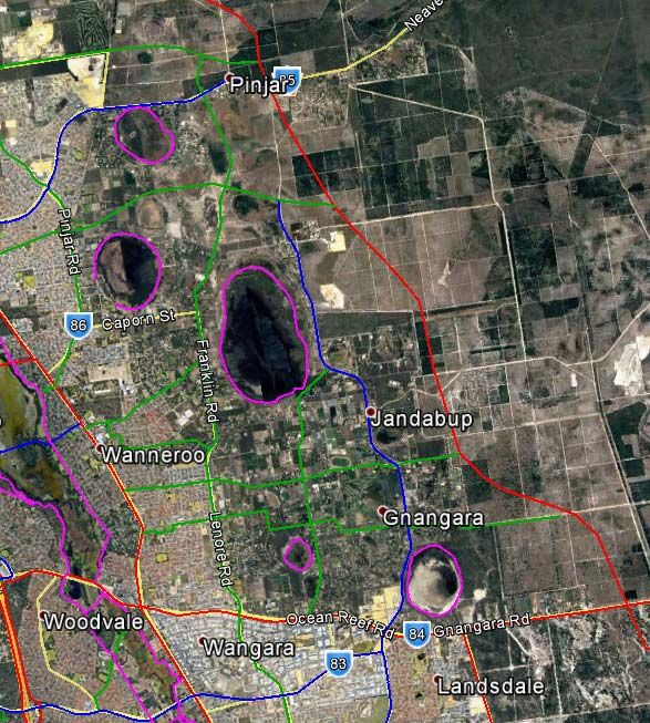
Road Planning Study Report

Executive Summary
The Department of Planning, Lands and Heritage have engaged Cardno to undertake a collaborative multi-
disciplinary planning study to review and provide updated road concept plans for the network in East
Wanneroo, in support of the proposed East Wanneroo District Structure Plan. The outputs from this study
comprise the design information required to commence land protection of the Other Regional Road reserves
in the Metropolitan Regional Scheme (MRS) to support planning within the study area and the basis upon
which to commence future design development of the road network concept.
The concept design has been developed through consideration of known and investigated constraints (refer
Section 3), proposed land uses, future public transport and servicing planning and forecast traffic volumes at
2051. Planning design and typical cross-sections are presented for the proposed Other Regional Road network
within the East Wanneroo District Structure Plan Area in Appendix B. This work is the basis upon which the
MRS land protection plans will be developed.
Recommended actions to progress the development of the road network concept include:
> Public Comprehensive Community Consultation on supporting land development, amenity, environmental
  and heritage considerations;
> Progression of engineering design development with detailed base data;
   - Detailed site survey (including topography, rail corridor & engineering service locations); and
   - Groundwater monitoring.
> Development of a District Water Management Strategy and Local Water Management Strategies to
  determine stormwater drainage whilst protecting natural watercourses within, and adjacent to, the study
  area;
> Commissioning of additional site-specific environmental assessments, mapping and reporting to confirm
  the values of priority areas identified in the Environmental Assessment Study;
> Confirmation of PTA rapid transit routes for buses;
> Confirmation of the proposed transit line alignment and stations, including development timing and
  coordination with the proposed road network;
> Key intersection preliminary design development and associated comprehensive traffic modelling;
> Confirmation of existing and future service planning requirements;
   - Site-specific protection requirements for existing water, gas, communications and power infrastructure;
   - Coordination of utilities network expansion (water, sewer, gas, communications and power) with
     project execution timing; and
   - Coordination and staging of service relocations, as required.
> Coordination of road upgrade timing with adjacent land use developments for optimisation of access and
  earthworks across the study area.

CW1016300 | 11 September 2019 | Commercial in Confidence                                                       iii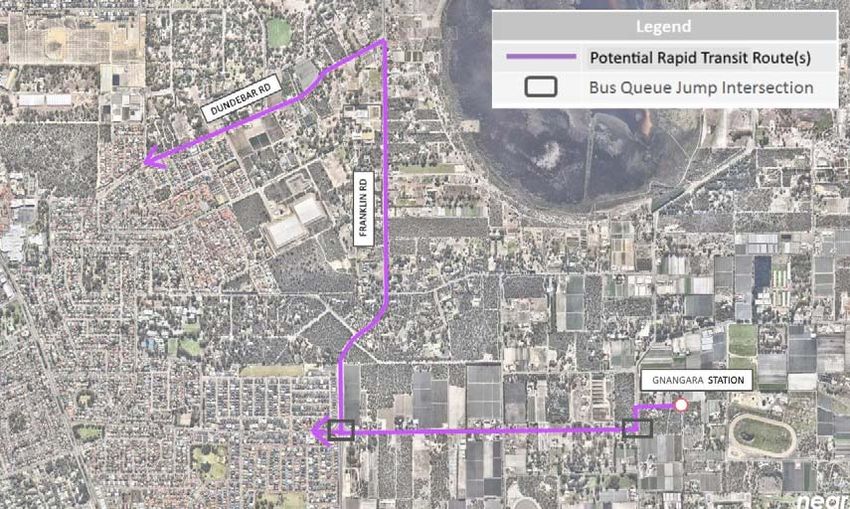
Road Planning Study Report

Table of Contents
       1         Introduction and Background                                                    1
                 1.1        Introduction                                                        1
                 1.2        Background and Scope                                                1
                 1.3        Methodology                                                         1
                 1.4        Current and Proposed Other Regional Roads                           1
                 1.5        Other Considered Roads                                              2
                 1.6        Scope Exclusions & Tie-ins                                          2
       2         Literature Review                                                              3
                 2.1        Sub-regional Planning Frameworks                                    3
                 2.2        Planning Studies and Schemes                                        4
                 2.3        Concept Designs by Others                                           5
                 2.4        Constraint Mapping                                                  6
                 2.5        Various Guidelines for Road Design                                  6
       3         Constraints Assessment                                                         7
                 3.1        Social Constraints                                                  7
                 3.2        Engineering Constraints                                            10
                 3.3        Environmental Constraints                                          12
       4         Transport Modelling                                                           14
                 4.1        Basis of the STEM Model                                            14
                 4.2        2051 Traffic Volumes                                               17
                 4.3        Key Intersection Summary                                           18
                 4.4        Proposed Intersection Treatments                                   19
                 4.5        Lane Configurations                                                20
                 4.6        Public transport Rapid Transit Routes                              21
                 4.7        Traffic Analysis Outcomes                                          22
       5         Concept Design Methodologies and Assumptions                                  24
                 5.1        Base Data                                                          24
                 5.2        Proposed Posted and Design Speeds                                  24
                 5.3        Concept Design Cross-section Parameters                            25
                 5.4        Road and Rail Interactions                                         29
                 5.5        Concept Design                                                     29
       6         Concept Design                                                                32
       7         Conclusions & Recommendations                                                 33
       References                                                                              34

CW1016300 | 11 September 2019 | Commercial in Confidence                                        iv
Road Planning Study Report

Appendices

Appendix A Draft East Wanneroo District Structure Plan
Appendix B Typical Road Cross Sections
Appendix C PTA Reference Drawings

Tables
Table 3-1     Aboriginal Heritage Sites within the EWDSP Area (AHIS 2019)                                           8
Table 3-2     European Heritage Sites within the EWDSP Area (inHerit 2019)                                          9
Table 4-1     Population living within the DSP by STEM Zone in 2051                                                15
Table 4-2     Employment within the DSP by STEM Zone in 2051                                                       16
Table 4-3     Key Intersections within the DSP                                                                     19
Table 4-4     Summary of Existing and Proposed Intersections                                                       22
Table 5-1     Posted and Design Speeds for ORR Links                                                               25
Table 5-2     Concept Design Cross-section Parameters                                                              26
Table 5-3     Stopping Sight Distance Design Criteria                                                              29
Table 5-4     Horizontal Alignment Design Criteria                                                                 29
Table 5-5     Vertical Alignment Design Criteria                                                                   30

Figures
Figure 2-1    North-west Sub-regional Planning Frameworks – Regional Roads (DPLH, 2018)                             3
Figure 3-1    Aboriginal Heritage Sites within the EWDSP Area (AHIS 2019)                                           8
Figure 3-2    Draft Bicycle Network Plan in East Wanneroo by 2050 (DoT 2018)                                        9
Figure 4-1    STEM model zones within the DSP                                                                      14
Figure 4-2    2051 East Wanneroo STEM Link Volume Plots                                                            17
Figure 4-3    Intersection Locations                                                                               18
Figure 4-4    Austroads Traffic Control at Intersections Options (extract)                                         19
Figure 4-5    Austroads traffic control based on functional road classification (extract)                          20
Figure 4-6    East Wanneroo DSP – Proposed Lane Configuration for ORR                                              21
Figure 4-7    Future Rapid Transit Routes                                                                          22
Figure 4-8    Graphical representation of proposed road link & intersections                                       23
Figure 5-1    Existing Posted Speeds (MRWA 2019)                                                                   24
Figure 5-2    RAV Category 7 Vehicle Combination Diagram (Main Roads Heavy Vehicle Services, 2018) 31

CW1016300 | 11 September 2019 | Commercial in Confidence                                                            v
Road Planning Study Report

Abbreviations
CW        Cossil & Webley                                  ORR     Other Regional Road
DBCA      Department of Biodiversity, Conservation         PRAMS Perth Regional Aquifer Modelling
          and Attractions                                        Systems
DoT       Department of Transport                          PRR     Primary Regional Road
DPLH      Department of Planning, Lands and                PSG     Project Steering Group
          Heritage
                                                           PTA     Public Transport Authority
DWER      Department of Water and Environmental
                                                           RAV     Restricted Access Vehicle
          Regulation
                                                           RPS     RPS Group
EAS       Environmental Assessment Study
                                                           STEM    Strategic Transport Evaluation Model
Emerge Emerge Landscape Associates
                                                           TEC     Threatened Ecological Communities
EWDSP East Wanneroo District Structure Plan
                                                           the City City of Wanneroo
GIS       Geographic Information System
                                                           WAPC    Western Australian Planning Commission
IWMF      Integrated Water Management
          Framework                                        WC      Water Corporation
MRS       Metropolitan Region Scheme                       WP      Western Power
MRWA      Main Roads Western Australia                     WYH     Whiteman Yanchep Highway

CW1016300 | 11 September 2019 | Commercial in Confidence                                                       vi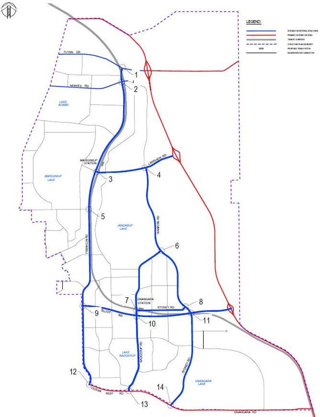
Road Planning Study Report

1         Introduction and Background

1.1       Introduction
Cardno have been engaged by the Department of Planning, Lands and Heritage (DPLH) to deliver this road
planning study report, which reviews the existing Planning Study for Primary Roads in East Wanneroo report
prepared by AECOM in 2010 and provides updated road concept plans for the regional movement network
in East Wanneroo in coordination with the proposed East Wanneroo District Structure Plan (EWDSP).

1.2       Background and Scope
In January 2011, the Western Australian Planning Commission (WAPC) published the draft East Wanneroo
Structure Plan (EWSP); a sub-regional level plan that provided a framework for the preparation of more
detailed structure plans for the locality. This is to form the basis for future Metropolitan Region Scheme
(MRS) amendments in the area.
The purpose of the EWSP was to ensure that the planning for the physical and community infrastructure of
the area is coordinated at a district level and that infrastructure and servicing are provided in an efficient,
equitable, accessible and timely manner to the future East Wanneroo community.
In addition to a regional movement network for the area, servicing infrastructure (including water, drainage,
sewerage, electricity, gas, and telecommunications) will be required as part of the development of the East
Wanneroo area. The capacity of the infrastructure will need to cater for the future population of the area and
support local industry, businesses and activity centres; be flexible in order to accommodate future changes,
and be staged in order to respond to budget constraints.
DPLH is currently reviewing the EWDSP which will provide guidance to the future land-use intensification,
employment and density targets, protection of environmental assets, coordination and provision of major
infrastructure based on Transport @3.5 Million and WAPC’s draft Perth and Peel @ 3.5 Million 2051)
planning frameworks. A draft of the EWDSP is provided in Appendix A.
This study report considers known and investigated constraints, proposed land uses, future public transport
plans and forecast traffic volumes to produce concept design drawings and indicative land protection plans
for the proposed Other Regional Roads (ORR) within the study area.

1.3       Methodology
This study aims to inform the EWDSP such that the ORR reserves are protected in the MRS to guide future
planning within the study area. To this end, the ORR network concept design has been developed in
consideration of the following activities:
> Identification, review and collation of relevant existing information and literature for the study area (refer
  Section 2);
> Key stakeholder liaison via DPLH;
> Coordination with DPLH for land use and road network integration during the evolution of the EWDSP
  concept;
> Analysis and interpretation of the Strategic Transport Evaluation Model (STEM) for a Perth population of
  3.5 Million in 2050 for transport scenarios (refer Section 4);
> ORR concept design including plan, profile, typical mid-block cross sections and key intersections (refer
  Section 6); and
> Identification of risks, constraints and considerations for future design development of the regional road
  network within the study area (refer Section 7).

1.4       Current and Proposed Other Regional Roads
The following roads within the EWDSP have been identified as having existing or future ORR status and are
considered in the development of the planning concept design (Appendix A):
> Lenore Road – From Ocean Reef Road to Franklin Road (approx. 500m north of Elliot Road);
> Franklin Road – From Lenore Road the Flynn Drive extension;

CW1016300 | 11 September 2019 | Commercial in Confidence                                                           1
Road Planning Study Report

> Elliot Road – From Lenore Road extending eastwards to the proposed Whiteman Yanchep Highway
  (WYH);
> Badgerup Road – From Ocean Reef Road to Hawkins Road;
> Sydney Road – From Ocean Reef Road extending northwards to Hawkins Road (ORR status ends north
  of Ross St, reverting to neighbourhood connector);
> Hawkins Road – From Badgerup Road to the Lakeview Road extension; and
> Lakeview Road – From Franklin Road to the proposed WYH.
The existing layout of the transport network will require that the following roads be extended to form the
EWDSP, enabling the required connectivity identified in planning frameworks:
> Franklin Road – Extended to replace Rousset Road and provide connectivity to the Flynn Drive
  extension;
> Elliot Road – Extended to replace Jambanis Road and Joyce Road and provide connectivity to the WYH;
> Sydney Road – Extending to provide connectivity to Hawkins Road; and
> Lakeview Road – Replacing Townsend Road and Amarante Road and providing connectivity to WYH.
Existing posted speeds within the study area for the above roads vary between 60 to 80km/h. Where the
existing roads revert to local access streets, the posted speeds drop to below 60km/h.
Each of the above roads have been designed to a concept level with consideration to horizontal and vertical
alignments.

1.5       Other Considered Roads
Although not identified as having a future ORR status, the following roads are deemed essential in the wider
connectivity of the proposed EWDSP road network and have also been considered in the planning design:
> Stoney Road – From Badgerup Road to Sydney Road; and
> Sydney Road Extension – From the Elliot Road extension to Hawkins Road (the existing layout of the
  transport network will require that Sydney Road be extended northwards to provide connectivity with
  Hawkins Road).
Each road has been designed to a concept level with consideration to horizontal alignments. Sydney Road
extension has also been designed to consider a concept vertical alignment.
Neighbourhood distributor roads (refer Appendix A) that require connection into the proposed ORR network
have been considered insofar that appropriate left-in, left-out turning pockets and median breaks for right-
turn access are accommodated within the intersecting ORR concept design.
The proposed Whiteman Yanchep Highway (WYH), concept design by Main Roads Western Australia
(MRWA), provides key tie-ins for east-west accessibility through the study area for the Flynn Drive extension
(concept design by others), and the Lakeview Road and Elliot Road extensions.

1.6       Scope Exclusions & Tie-ins
Although identified as ORRs within the EWDSP area, designs for Neaves Road and Flynn Drive have been
undertaken by others. The concept design is such that it ties in with these ORRs in horizontal and vertical
alignments for the purposes of intersection design, as far as practicable.
Intersection design to the Primary Regional Roads (PRR) bordering the study area have been excluded from
the scope. The planning concept design ties-in to the PRRs with the assumption that vertical and horizontal
alignments are fixed at these intersections. Allowance has been made for ensuring upstream road cross-
sections are accommodated and sufficient land is identified for upgrades to these intersections, as required,
in the future:
> Lenore Road and Ocean Reef Road;
> Badgerup Road and Ocean Reef Road; and
> Sydney Road and Ocean Reef Road.

CW1016300 | 11 September 2019 | Commercial in Confidence                                                        2
Road Planning Study Report

2            Literature Review

Cardno have conducted a review of the existing environmental, planning and engineering documents as part
of the literature review for the EWDSP, as detailed below.

2.1          Sub-regional Planning Frameworks
The Perth and Peel @ 3.5 Million Sub-regional Planning Frameworks for the North-West Sub-region
identifies roads within the study area proposed to become Integrator Arterial standard roads.

Figure 2-1     North-west Sub-regional Planning Frameworks – Regional Roads (DPLH, 2018)

The proposed alignments of the regional roads align with those previously identified in AECOM’s Planning
Study for Primary Roads in East Wanneroo (AECOM 2010), with changes to reflect MRWA’s WYH design.
The overall layout and specific locations and/or alignments of the regional roads identified in the sub-regional
planning frameworks differ slightly from those identified for consideration in this road planning study. The
following changes to the proposed network are noted:
> The Ranch Road Extension from Pinjar Road to WYH has been replaced with Lakeview Road from the
  Franklin Road Extension to WYH with no ORR status connectivity through to Pinjar Road;
CW1016300 | 11 September 2019 | Commercial in Confidence                                                           3
Road Planning Study Report

> Sydney Road between the proposed Stoney Road and Sydney-Hawkins Road intersection is not to
  receive ORR status; and
> Adjustments to road and intersection alignments throughout the study area to comply with road design
  standards.

2.2       Planning Studies and Schemes
2.2.1     Metropolitan Region Scheme
The Metropolitan Region Scheme (MRS) provides a legal basis for planning within the Perth metropolitan
region by dividing it into zones and reservations used to define future land uses.
In accordance with the MRS, the EWDSP area is spread across multiple map sheets:
> Map Sheet 7 – Neerabup;
> Map Sheet 8 – Ellenbrook Townsite;
> Map Sheet 11 – Kingsley; and
> Map Sheet 12 – Whiteman Park.
Within the MRS, the only roads with existing ORR status within or near the EWDSP area are Pinjar Road,
Joondalup Drive and Ocean Reef Road. Wanneroo Road to the west is an existing PRR. The subregional
frameworks identify that Ocean Reef Road is to be upgraded to PRR status.
The MRS mapping indicates that the majority of the EWDSP area is zoned Urban Deferred, Parks and
Recreation and Rural. A number of Bush Forever Sites have also been identified within the MRS.

2.2.2     East Wanneroo District Structure Plan
The East Wanneroo District Structure Plan is being prepared in parallel with this study to reflect the land use
intensification expectations outlined in the Perth and Peel@3.5million (DPLH 2018) and North-West Sub-
regional Planning Framework (DPLH 2018) reports. Cardno have worked closely with DPLH to ensure the
ORR road concept supports the proposed EWDSP and associated land use changes being considered to
year 2050.

2.2.3     East Wanneroo District Structure Plan Engineering Servicing Report
Cossil & Webley (CW) were engaged by DPLH to prepare an Engineering Service Report for the East
Wanneroo District Structure Plan Area, producing their East Wanneroo District Structure Plan Engineering
Servicing Report (Cossil & Webley 2019). The purpose of this report was to summarise the results of an
engineering assessment of servicing strategies and constraints in the EWDSP area. The preparation of the
report is based on preliminary advice received from various service authorities, the findings of which are
discussed further in Section 3.2

2.2.4     Environmental Assessment Study
Emerge Associates (Emerge) were engaged by DPLH to prepare an Environmental Assessment Study
(EAS), producing their Environmental Assessment Study – East Wanneroo District Structure Plan report
(Emerge Associates 2018). The aim of the EAS was to investigate, at a district level, the areas of
environmental significance that should be protected.
Key findings of the EAS identified known occurrences of Threatened Ecological Communities (TEC),
threatened and priority flora and fauna habitat, groundwater dependent ecosystems and conservation
category wetlands.
Data compiled by Emerge has been reviewed and used to inform the alignments of the concept design.
Where practicable, effort has been made to ensure the concept road design does not impact upon identified
conservation areas whilst maintaining minimum road design requirements for safety. Refer Section 3.3 for
discussion of the key environmental constraints identified by Emerge and the corresponding impact on the
proposed alignment of the ORRs.

2.2.5     Integrated Water Management Framework
RPS Group (RPS) were engaged by DPLH to inform water management and design objectives and guide
future preparation and finalisation of future documents for the EWDSP area, producing their Integrated
Water Management Framework – East Wanneroo District Structure Plan report (RPS Group 2019).

CW1016300 | 11 September 2019 | Commercial in Confidence                                                        4
Road Planning Study Report

The key finding relating to the proposed ORR alignments identified in the Integrated Water Management
Framework (IWMF) states that modelling recently undertaken by DWER to estimate future groundwater
levels suggest several areas of the EWDSP will be inundated with water by 2030. This is expected as a
function of increased recharge and lower evapotranspiration in the EWDSP area, due to removal of the pines
and extensive urbanisation, resulting in the Superficial aquifer groundwater levels increasing 3-4m.
In order to reduce development costs and unnecessary use of raw materials, critical design criteria will need
to be determined in a future District Water Management Strategy, to set a controlled groundwater level
across the EWDSP area. More detailed and targeted modelling is recommended to inform this, with the
model intended to better inform changes in water balance as a result of changing land uses and assess
options to control groundwater.
Drainage is suggested to be managed at-source as much as practical, with any remaining run-off that cannot
be managed at-source conveyed to treatment systems such as bioretention basins or equivalent.

2.3       Concept Designs by Others
To inform the broad alignments of the proposed ORRs and their interfacing to future roads and other modes
of transport within the EWDSP area, relevant planning studies and designs prepared previously were
reviewed. The following sections address the relevant studies and designs prepared within the study area,
and the anticipated role these play in the roads planning concept design. Consideration will be required for
the coordination and interfacing of earthworks between the concept ORR and future adjacent land
development.

2.3.1     AECOM’s Planning Study for Primary Roads in East Wanneroo
AECOM were engaged by DPLH to undertake a planning study for the primary regional roads in East
Wanneroo in 2010, producing their Planning Study for Primary Roads in East Wanneroo report (AECOM
2010). The aim of this study was to prepare initial planning concepts for the roads identified in the regional
road network, accommodating the movement requirements of the network while minimising impacts on
environmentally sensitive areas, properties, and existing and planned major services that would control the
road alignment and reservation requirements.
The proposed alignments were reviewed by Cardno against updated constraints and study inputs, to identify
areas of concern and allow for refinements to the previous alignments.

2.3.2     MRWA’s Whiteman Yanchep Highway
MRWA’s Whiteman Yanchep Highway (WYH) is a proposed north-south route in the north-west corridor of
Perth, intended to ease traffic on Wanneroo Road and the Mitchell Freeway as a function of forecast
population growth.
WYH is identified in the sub-regional planning frameworks as a PRR. The proposed WYH alignment and
interchange locations supersede some of the network movements assumed in AECOM’s Planning Study,
particularly with the interfacing of WYH with Neaves Road.
The latest design for WYH (dated October 2017) was obtained from MRWA to overlay with Cardno’s
planning concept design to allow for coordination of horizontal and vertical alignments to the proposed
interchanges. Minor amendments will be required to MRWA design to accommodate the adjusted approach
alignment at Lakeview Road. Elliot Road concept design ties in with MRWA ramp approach alignment.

2.3.3     Arup Rail Alignment
Arup were engaged by METRONET to undertake a design concept for a passenger rail alignment through
the EWDSP area, producing their East Wanneroo District Rail Alignment – Land Reservation Study (Arup
2018). The preparation of the rail alignment design aims to assist in identifying future transit corridors to
maximise land use benefits.
Cardno’s design concept for other regional roads within the study area assumes road over rail grade
separations at conflict points, noting DPLH’s preference to provide underground transit stations at
neighbourhood and town centres.
Given the changes to the EWDSP and ORR designation since the completion of the rail study – in particular
the shift of the road alignment to the western side of the rail alignment - and the further identification of
environmental conservation areas, the horizontal alignment of the transit corridor has been adjusted to
accommodate and be directly adjacent to the concept ORR design, as appropriate. Vertical coordination
between adjacent road and rail infrastructure (particularly along Elliot Road and Franklin Road) will need
particular attention in future design development.
CW1016300 | 11 September 2019 | Commercial in Confidence                                                         5
Road Planning Study Report

2.4       Constraint Mapping
Constraint mapping was conducted to determine the critical project constraints likely to affect or dictate the
concept design. Social and environmental constraints were informed from GIS data obtained from the City of
Wanneroo, as well as from publicly available datasets.
Environmental constraint mapping was produced from the data provided by Emerge, in line with their EAS,
with the objective to identify and avoid areas of environmental significance in setting the alignments of the
ORRs.
Information and data relating to engineering constraints was obtained through Dial Before You Dig enquiries
for existing services, review of available literature and planning investigations, and through direct liaison with
relevant service providers and stakeholders.
Refer Section 3 for constraint mapping.

2.5       Various Guidelines for Road Design
The most recent Austroads publications, with relevant MRWA supplements, have been reviewed to determine
the design requirements for the EWDSP concept road design. These include:
> Austroads Guide to Road Design Part 3 – Geometric Design (2017);
> MRWA Supplement to Austroads Guide to Road Design – Part 3 (2019);
> Austroads Guide to Road Design Part 6 – Roadside Design Safety and Barriers (2018);
> MRWA Supplement to Austroads Guide to Road Design – Part 6 (2019);
> Austroads Guide to Road Design Part 6A: Paths for Walking and Cycling (2017);
> MRWA Supplement to Austroads Guide to Road Design – Part 6A (2019); and
> Standard Restricted Access Vehicle (RAV) Route Assessment Guidelines (2018).

CW1016300 | 11 September 2019 | Commercial in Confidence                                                          6
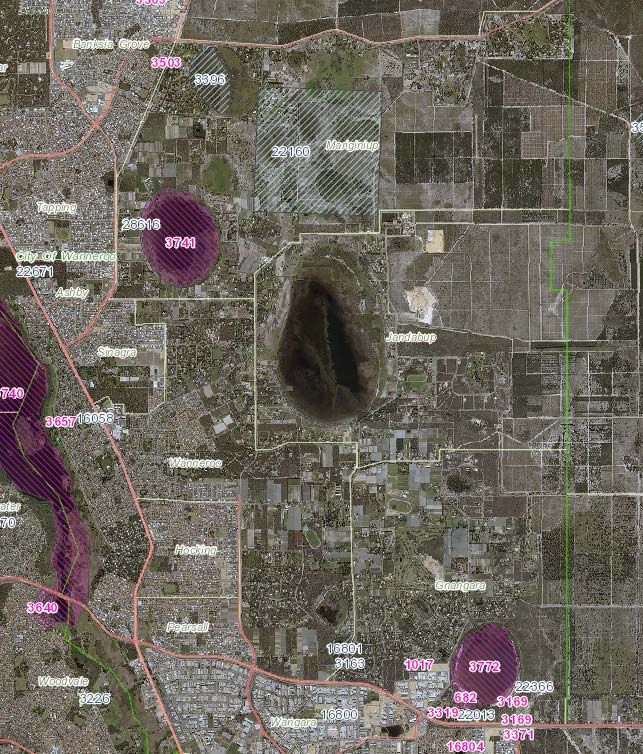
Road Planning Study Report

3          Constraints Assessment

A desktop constraint mapping exercise was undertaken to identify the social, environmental and engineering
constraints within the study area, to determine critical constraints that would dictate the alignment of the
concept design. Identified constraints are outlined and discussed in the following sections.

3.1        Social Constraints
Social constraints were identified through liaison with the City of Wanneroo and the use of their online
Intramaps, as well as from geographic information system (GIS) data obtained from DPLH.

3.1.1      Land Zoning
Within the MRS, the study area contains the following land zonings:
> Parks and Recreation;
> State Forests;
> Water catchments;
> Primary regional roads;
> Other regional roads;
> Public purposes;
> Rural;
> Rural – water protection;
> Urban; and
> Urban Deferred.
The EWDSP aims to provide a further framework for the planning, assessment, coordination and
implementation of major development initiatives within the study area, further building upon the MRS.
In comparison to the MRS, the EWDSP proposes to reduce the amount of rural zoned land and increase the
amount of urban land, proposing suburban and urban neighbourhoods, with special residential and character
areas adjacent to district centres and parklands. Furthermore, additional industrial areas not identified in the
MRS are proposed to the east and north boundaries of the EWDSP area abutting the Whiteman Yanchep
Highway.
The EWDSP also identifies the proposed ORR alignments and wider transport network, including
neighbourhood connector roads and rail corridor.

3.1.2      Existing Land Use
Much of the existing study area identified for urbanisation consists of rural and residential land uses.

3.1.3      Aboriginal Heritage Sites
A summary of the Aboriginal Heritage sites within the study area and close to proposed ORRs are presented
in Table 3-1 and Figure 3-1 below.

CW1016300 | 11 September 2019 | Commercial in Confidence                                                         7
Road Planning Study Report

Table 3-1      Aboriginal Heritage Sites within the EWDSP Area (AHIS 2019)

 Site ID                                  Site Name

 682                                      Gnangara Lake SW 1 (Registered Aboriginal Site)

 3163                                     Little Badgerup: Swamp (Other Heritage Place)

 3396                                     Lake Adams (Other Heritage Place)

 3772                                     Gnangara Lake (Registered Aboriginal Site)

 16801                                    Gnangara Site 3 (Other Heritage Place)

 22160                                    Marrynginup (Other Heritage Place)

Figure 3-1     Aboriginal Heritage Sites within the EWDSP Area (AHIS 2019)

3.1.4        European Heritage Sites
A summary of the European Heritage sites within the study area and close to proposed ORRs are presented
in Table 3-2 below.
In accordance with the inHerit listing, places listed are Heritage Listed by the City of Wanneroo in their
Municipal Inventory. Accordingly, the sites are protected under the Planning and Development Act (2015)
and the Local Planning Scheme.

CW1016300 | 11 September 2019 | Commercial in Confidence                                                          8
Road Planning Study Report

Table 3-2       European Heritage Sites within the EWDSP Area (inHerit 2019)

 Place Number           Site Name

 9493                    Delamare House (Hopkins House)

 9505                   William Townsend House

 9514                   Berriman House

 17940                  Tom Neaves House

 17529                   East Wanneroo School Site

3.1.5        Cycling Facilities
In line with the Perth and Peel@3.5million Sub-regional Frameworks, the Department of Transport (DoT) and
Public Transport Authority (PTA) have prepared a Draft Bicycle Network Plan across the Perth and Peel
Region. An extract of this network plan was provided by DoT is shown in Figure 3-2 below.

Figure 3-2      Draft Bicycle Network Plan in East Wanneroo by 2050 (DoT 2018)

The functions of the various paths within the network plan are summarised in the Draft Bicycle Network Plan.
DoT has advised that the exact form of the proposed cycle facilities have not yet been determined,
requesting that road reserves are made sufficient to allow provision of protected and/or separated facilities.
The ORR concept design within the study area has both Principal Shared Paths and Shared Paths provided
within the proposed road reserve, as shown in the typical road cross sections (refer Appendix B).

CW1016300 | 11 September 2019 | Commercial in Confidence                                                         9
Road Planning Study Report

3.2       Engineering Constraints
Given the existing rural land zoning of the EWDSP area, and the intense urbanisation proposed in the
EWDSP, it is expected that many of the existing services will require upgrades to accommodate for future
demand, as well as consideration for future trunk mains and services to meet the demands of the study area.
Engineering servicing constraints within the EWDSP area were also investigated and summarised in CW’s
East Wanneroo District Structure Plan Engineering Servicing Report (Cossil & Webley 2019).
The following sections summarise the findings of investigations, and should be read in conjunction with CW’s
report.

3.2.1     Proposed Water/Wastewater Headworks
Existing water infrastructure within the EWDSP is limited to the western and southern extents of the study
area, with conceptual headworks planning for water and wastewater infrastructure having been updated c.a.
2010 based on the extent of the EWDSP area at the time.
It was noted that the concept plans only provide indications as to the likely service infrastructure
requirements and service corridors, with some of the infrastructure shown on the conceptual plans having
already been constructed. Since the initial conceptual headworks plans were produced, the study area has
expanded and experienced a change in land use and structure planning. Comments received by Water
Corporation indicate that the previous conceptual planning would need to be reviewed and revised once the
ultimate dwelling/population yields and land uses are determined from DPLH structure planning.
To address water servicing requirements, CW’s investigations propose future water trunk mains aligning to
the Lenore Road and Franklin Road alignments, as well as bore mains to convey water from the Wanneroo
Ground Water Treatment Plant to elevated water tanks. Significant trunk mains are proposed adjacent to
and/or around district centres.
For wastewater, CW’s investigations propose a number of gravity and pressure mains traversing the study
area, and various wastewater pump stations at the low points of the respective sewer catchments. Routes
for the proposed mains have been aligned to the proposed ORRs where practicable, although it is noted a
number of the routes will revert to what will likely become lower order local roads.
Water Corporation will ultimately determine the most suitable location, alignment and/or route for
infrastructure when the need arises, based on the lands available.
The ORR concept design provides verge and median space within the road reserve for local sewer and
water infrastructure, noting that regional distribution infrastructure will require more detailed investigation
upon confirmation of Water Corporation’s strategic planning.

3.2.2     Gas
There is currently limited reticulated gas infrastructure within the EWDSP area, confined to the outskirts and
within existing residential and commercial/industrial areas.
ATCO do not currently have plans for new infrastructure within the area. They have noted that as land
development occurs, developers will need to apply for mains extensions and reticulation for new estates, via
high, medium and low-pressure reticulation mains.
Of the limited infrastructure within the EWDSP area, a high-pressure gas main and pressure reduction
station is present along Neaves Road. Any new roads or constructions works in the vicinity of this high-
pressure gas main will trigger additional design and construction requirements, in order to protect the
pipeline.
The ORR concept design provides verge and median space within the road reserve for local gas
infrastructure, noting that more detailed investigation will be required upon confirmation of land development
staging and the corresponding servicing demands, especially in ensuring alignments avoid and/or provide
sufficient separation to sources of Earth Potential Rise.

3.2.3     Power
CW’s investigations indicate that a 132kV transmission line will be required, providing connectivity between
the Neerabup Terminal Station and Wangara Power Substation in servicing the EWDSP area. The proposed
route for this transmission line traverses the following road reserves from north to south through the EWDSP
area:
> Flynn Drive between the Neerabup Terminal Station and Franklin Road extension;

CW1016300 | 11 September 2019 | Commercial in Confidence                                                          10
Road Planning Study Report

> Franklin Road extension to Neaves Road;
> Portion of Neaves Road proposed to become a local access street east of Franklin Road;
> Extension of Hawkins Road north of Lakeview Road (neighbourhood connector standard road);
> Hawkins Road;
> Badgerup Road;
> Elliot Road between Badgerup Road and Lenore Road; and
> Lenore Road.
Western Power have identified that a future zone substation may also be required, although this is uncertain
and subject to medium to long-term needs. Any such substation would require extension of high voltage
transmission lines, and ideally be located along the proposed transmission line extensions.
Transmission lines would be located within existing road reserves where possible.
It would be expected that road infrastructure upgrades, as a function of urban development, would see the
undergrounding of existing low and high voltage overhead power assets.
The ORR concept design provides verge and median space within the road reserve for local power
infrastructure, noting that more detailed investigation will be required upon confirmation of power demand
locally and across the EWDSP area. Where transmission lines are required, the proposed road reserves are
unlikely to have sufficient verge and/or median widths to accommodate the associated 20m restriction zones,
resulting in restrictions being applied to adjacent lands.

3.2.4     Communications
Future communications and upgrades to the EWDSP area will be performed by NBN, as part of frontal
greenfield developments from the west and/or south.
Based on CWs’ investigations, NBN have existing networks adjacent to the study area. These will be used to
facilitate servicing demands, with NBN advising that two 100mm diameter conduits will be required in PRR
and ORR designated roads.
Such requirements are expected to be easily accommodated within the standard verge widths proposed.

3.2.5     Existing Drainage
Most existing local roads within the EWDSP area are constructed to a rural standard. Stormwater runoff is
managed via sheet-flow to the shoulders and verges, where it is assumed to infiltrate at source.
Roads recently upgraded to an urban standard have incorporated kerbed cross-sections, and appear to
drain through pit and pipe networks with outfalls to infiltration basins. The recently upgraded roads include:
> Major intersections of Ocean Reef Road, with:
   - Lenore Road;
   - Badgerup Road; and
   - Sydney Road.
> The recently upgraded section of Lenore Road up to and immediately beyond Elliot Road.
Given the proposed urban cross-sections to be adopted for the ORRs across the EWDSP area, it is
anticipated that pit and pipe networks will be adopted. Outfalls for these networks are expected to convey
stormwater runoff to infiltration basins, roadside swales, and/or the main water bodies in the surrounding
areas (subject to treatment requirements and groundwater).

3.2.6     Groundwater Levels
The ‘Integrated Water Management Framework – East Wanneroo District Structure Plan’ (July 2019)
prepared on behalf of DPLH by RPSGroup identifies water management outcomes for groundwater
management. The DSP is located on the Gnangara Groundwater System, predominantly in the Wanneroo
Groundwater Management area.
Perth Regional Aquifer Modelling Systems (PRAMS) modelling suggests that future groundwater levels in
the superficial aquifer are expected to increase by 3 to 4m over most of the DSP resulting in a significant
proportion of the area being inundated – predominantly in the existing geomorphic wetlands. The Water

CW1016300 | 11 September 2019 | Commercial in Confidence                                                         11
Road Planning Study Report

Management Framework identifies that groundwater controls will need to be put in place and additional
groundwater modelling will be required to update the PRAMS model.
RPSGroup PRAMS Groundwater Levels mapping, sourced via Landgate in August 2018 was used to identify
high groundwater levels in the study area. The concept design aims to avoid areas of high groundwater
(levels above natural ground level) where practicable. Where passing through areas of high groundwater
levels has proven unavoidable, the concept design has assumed a nominal additional 1.0m lift in earthworks
for the concept design. As future groundwater controls and drainage management practises are yet to be
confirmed, this is deemed an acceptable measure as confirmed by DPLH and based on Cardno’s experience
at this stage of design.

3.2.7     Existing/Proposed Alignment
As a function of the transport network proposed within the EWDSP, wholesale realignments of proposed
ORRs, widening of existing road reserves and extensions will be required to meet standard geometric
requirements as specified by Austroads and MRWA’s Supplements.
Such realignments, widenings and extensions will necessitate the relocation and/or replacement of a
significant extent of existing services, as well as reconstruction of existing rural standard roads.

3.3       Environmental Constraints
The EAS prepared by Emerge has been used to inform the environmental constraints present within the
study area, and formed the basis for determining suitable ORR alignments such that significant
environmental values are conserved as much as practicable. Desktop and site investigations were drawn
upon to inform the findings of the EAS, with the relevant digital datasets referenced into the modelling to set
appropriate alignments.
The following sections outline specific constraints identified in the EAS, and their impacts on the proposed
ORR alignments, and should be read in conjunction with the EAS report. It is noted that the EAS has also
identified areas for further investigation.

3.3.1     Soils
Desktops studies have revealed that the site is likely to comprise sandy soils, and poorly drained peaty and
clayey soils in parts of the site aligned with wetland features. Areas with poorly draining soils will limit the
effectiveness of infiltration drainage systems, requiring alternate methods of stormwater runoff management.

3.3.2     Topography
The topography of the study area varies from hilly and undulating to gentle dunal formations. Low lying areas
typically coincide with wetland features.
Without further consideration of development and future earthworks levels, the vertical alignments of the
proposed ORRs will be based off the existing ground levels and previous design tie-ins.
Additional fill may be required in locations to raise the design centreline, where reduced clearance to
groundwater is a concern.

3.3.3     Threatened Ecological Communities
Emerge’s EAS investigations identified Banksia Woodlands as a listed Threatened Ecological Community
(TEC) located within the study area. The Tuart Woodlands were also noted within Emerge’s report and
potential occurrences considered, although at the time of the EAS being prepared the outcome regarding its
nomination to be listed as a TEC had not been reached.
The EAS notes that detailed surveys have not been conducted across the study area, and that there is a
high likelihood that additional occurrences of TECs could be found to exist.
Wherever possible, and in adhering to geometric design standards and guidelines, the horizontal and vertical
alignments have been developed to minimise impacts on TECs identified within the study area.

3.3.4     Bush Forever
The vast majority of bush forever sites identified within the study area are noted to coincide with other areas
of environmental value.
Bush Forever sites have been avoided as far as practicable in the development of the proposed ORR
alignments.

CW1016300 | 11 September 2019 | Commercial in Confidence                                                       12
Road Planning Study Report

3.3.5     Wetlands
As with the TECs, and in adhering to geometric design standards and guidelines, the horizontal and vertical
alignments have been developed to minimise impacts on conservation category wetlands, and avoid
resource enhancement and multiple use wetlands where possible.
The EAS does note that some of the current wetland classifications may be over or under-stated, requiring
detailed site investigations to confirm whether existing classifications are relevant.

CW1016300 | 11 September 2019 | Commercial in Confidence                                                    13
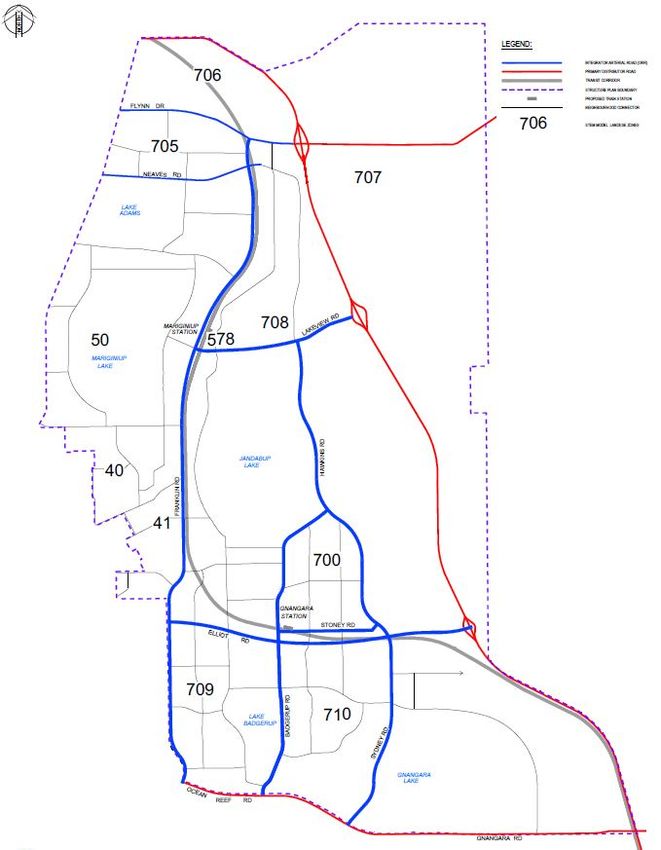
Road Planning Study Report

4            Transport Modelling

It is imperative that the proposed network and road concept design integrate with the abutting land use and
network plans. STEM modelling is ideal for this high-level assessment across the study area and the project
process consisted of the following:
> A review of the existing zone structure of the DSP area in the STEM model in relation to the proposed
  DSP layout
> A review of the future STEM model plots such as Link Volume plot to suggest proposed intersection
  treatment forms

4.1          Basis of the STEM Model
The STEM model is managed by the Department of Transport (DoT), Western Australia. STEM is a full multi-
modal model with representation of road / public transport network and uses a strategic level land use zoning
system to generate predicted traffic data. Within the STEM Model the study area has been aggregated into
Zones (refer Figure 4-1) in which assumptions pertaining to land use, public transport use and employment
have been provided to form a land use scenario resulting in traffic generation on regional roads.
Figure 4-1     STEM model zones within the DSP

DoT Transport Model (STEM) is developed for estimating regional traffic volumes on regional and major
roads and public transport patronage at rail and bus routes, and it is to be used only for strategic level of
decision-making process and interpreted by an experienced/qualified person who understands transport
modelling and the limitations of the data. The data is not intended for commercial or detailed transport
design use.

CW1016300 | 11 September 2019 | Commercial in Confidence                                                         14
Road Planning Study Report

Table 4-1 & Table 4-2 provide population and employment estimates, respectively for the 2051 scenario
within the STEM Model.
Table 4-1     Population living within the DSP by STEM Zone in 2051

                                                    Population
             Zone         No. Dwellings                               Children     Students
                                                     (Total)

               41              3 000                  8 334            1 833        1 333

               50              8 000                  22 056           4 853        3 529

              700             12 000                  32 885           7 234        5 262

              705              4 050                  11 251           2 475        1 800

              706                 -                      -               -             -

              707                 -                      -               -             -

              708              5 000                  13 702           3 014        2 192

              709              4 000                  10 979           2 415        1 757

              710              9 000                  24 688           5 431        3 950

            TOTAL             45 050                 123 895          27 255        19 823

CW1016300 | 11 September 2019 | Commercial in Confidence                                                  15
Road Planning Study Report
Table 4-2 Employment within the DSP by STEM Zone in 2051
Zone Agriculture Mining Manufactu Utilities Constructi Retail Wholesale Transport Communic Finances Public Education Health Welfare & Entertainm
ring on ations Administra Others ent
tion
41 8
1 ‐ 6 109 57 4 16 2 80 20 265 58 38 80
50 ‐ ‐ ‐ ‐ ‐ 500 ‐ ‐ ‐ ‐ ‐ 445 ‐ ‐ ‐
700 ‐ ‐ ‐ ‐ ‐ 1,200 ‐ ‐ ‐ 150 ‐ 445 ‐ 150 200
705 ‐ ‐ ‐ ‐ ‐ 500 ‐ ‐ ‐ ‐ ‐ 90 ‐ ‐ ‐
706 ‐ 150 2,290 254 1,345 1,204 1,030 710 113 658 38 ‐ 38 56 118
707 ‐ 19 286 32 168 150 129 89 14 82 5 ‐ 5 7 15
708 ‐ 97 1,483 165 871 780 667 460 73 426 24 ‐ 24 37 76
709 ‐ ‐ ‐ ‐ ‐ ‐ ‐ ‐ ‐ ‐ ‐ 265 ‐ ‐ ‐
710 7 14 128 11 203 175 35 36 5 128 41 400 96 64 159
TOTAL 15 281 4,187 468 2,696 4,566 1,865 1,311 207 1,524 128 1,910 221 352 648
CW1016300 | 11 September 2019 | Commercial in Confidence 16Road Planning Study Report
4.1.2 Transit Station Model inputs
The rail boarding numbers and public transport patronage is estimated in STEM based on a number of
factors. The key influencing factors for rail boarding include:
The land use type, yield and location relative to train stations.
The location and quantity of Park and Ride.
For 2051, STEM assumes a High Public Transport (HPT) scenario. This is based on an assumption that by
2051, Perth will achieve a higher mode share target of over 10% PT. Transit station modelling in 2051 for the
East Wanneroo Line within the STEM Model assumes:
Gnangara Station – 10,702 total daily boarding & 10,990 total daily alighting
East Wanneroo Station – 9,948 total daily boarding & 10,045 total daily alighting
In addition, bus routes within the DSP are included in the model – refer Section 4.6 for rapid transit routes
servicing transit stations.
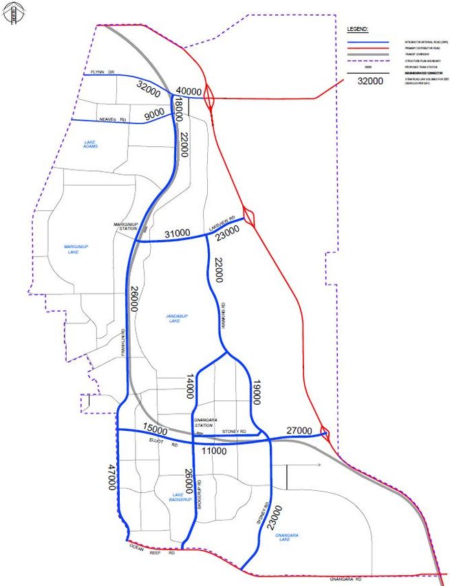
4.2 2051 Traffic Volumes
Figure 4-2 shows the 2051 East Wanneroo STEM Link Volume Plots (LVP) that provide indicative traffic
volumes on key roads within the DSP for the 3.5Million Perth population scenario. The volumes provided
show the highest predicted volume of vehicles per day for the ORR to ORR link.
Figure 4-2 2051 East Wanneroo STEM Link Volume Plots
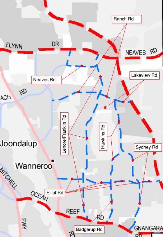
CW1016300 | 11 September 2019 | Commercial in Confidence 17Road Planning Study Report 4.3 Key Intersection Summary Figure 4-3 shows the key intersections in the study area. Detailed SIDRA analysis for the intersections was not included in this scope of work; therefore, the intersection design solutions (refer Section 4.4) presented are based on STEM traffic flows only. Department of Transport developed the 2051 link volume plots using the STEM model. The STEM model includes land use assumptions for the 3.5 million Perth population scenario and a zone boundary map with appropriate centroid connectors for the DSP area. Cardno reviewed the 2051 STEM model link volume plots for all the key intersections. Table 4-3 summarises the list of critical intersections in the DSP area. Figure 4-3 Intersection Locations CW1016300 | 11 September 2019 | Commercial in Confidence 18
Road Planning Study Report
Table 4-3 Key Intersections within the DSP
Intersection Intersecting roads STEM Node Plot Reference
1 Franklin Road & Flynn Drive 30600
2 Neaves Road & Franklin Road 20100
3 Lakeview Road & Franklin Road 20504
4 Lakeview Road & Hawkins Road 20506
5 Franklin Road & Caporn Street 16567
6 Badgerup Road & Sydney Road & Hawkins 20503
Road
7 Stoney Road & Badgerup Road Not available
8 Sydney Road & Stoney Road Not available
9 Lenore Road/ Franklin Road & Elliot Road 16547
10 Badgerup Road & Elliot Road 20502
11 Sydney Road & Elliot Road 17001
12 Lenore Road & Ocean Reef Road 16034
13 Badgerup Road & Ocean Reef Road 20012
14 Sydney Road & Ocean Reef Road 20153
4.4 Proposed Intersection Treatments
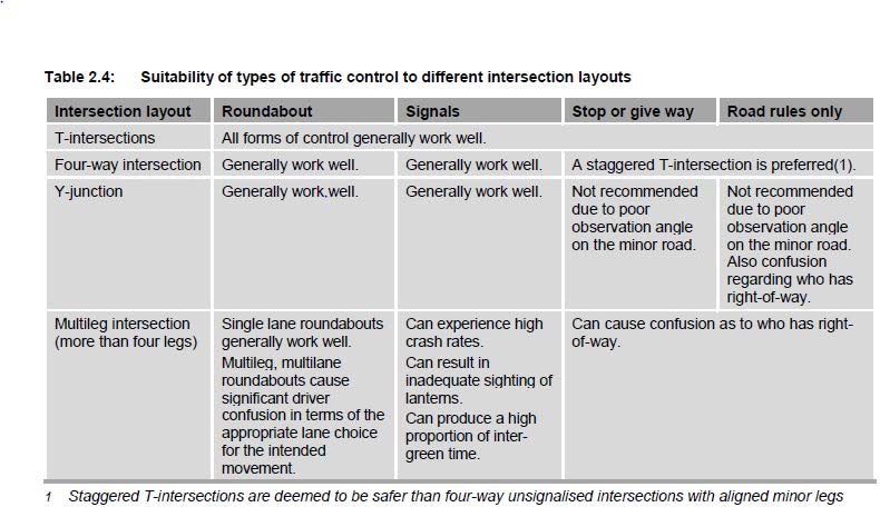
MRWA Traffic Guidelines and Austroads ‘Guide to Road Design, Part 4: Intersections and Crossings’ (2019)
provide guidance on selection of intersection treatments. Austroads provides guidance to the suitability of
types of traffic control to different intersection layouts based upon control options, traffic and safety factors,
as summarised in Figure 4-4 below – an extract from the abovementioned Austroads document.
Figure 4-4 Austroads Traffic Control at Intersections Options (extract)
Additionally, a broad guide to the suitability of traffic control with respect to the functional classification of the
road is provided by Austroads to provide a satisfactory level of safety and serviceability on arterial roads.
CW1016300 | 11 September 2019 | Commercial in Confidence 19Road Planning Study Report Figure 4-5, an extract from the Austroads ‘Guide to Road Design, Part 4: Intersections and Crossings’ (2019), provides suitability for each type of traffic control based upon the road type and has been taken into consideration when determining preferred intersection treatments within the study area. Figure 4-5 Austroads traffic control based on functional road classification (extract) STEM Link Volume Plots (summarised in Figure 4-2) have been used to infer turning volumes and expected intersection turning treatments. Where projected volumes and functional road classification treatment options (Figure 4-5) result in both signalised and roundabout viable treatment options, roundabout has been selected (unless otherwise directed) to ensure a complying and conservative approach to land protection requirements for planning purposes. Individual intersection modelling will be required in future project development to confirm the intersection treatments including numbers of turning lanes, length of turning pockets and length requirements for channelised intersections. 4.5 Lane Configurations Based on the STEM model traffic volumes (refer Figure 4-2), the number of traffic lanes required to support traffic flow along the ORR within the study area are presented in Figure 4-6. STEM Volumes have been compared with lane requirements using the Federal Highway Authority Technical Report - Simplified Highway Capacity Calculation Methods for Highway Performance Monitoring System, Oct 2017. Cardno’s modelling experience suggests any sections of road exceeding 20,000 vehicles per day requires four lanes, unless there is even flow throughout the day, in which case 2 lanes will suffice. For the purposes of this study, uneven flow is assumed with 10% AADT occurring within AM & PM peak periods. Figure 4-6 shows the East Wanneroo DSP proposed lane configuration for the Other Regional Roads (ORR). The typical cross-sections for each portion of road are presented in Error! Reference source not found., as further detailed in 5. CW1016300 | 11 September 2019 | Commercial in Confidence 20
Road Planning Study Report

Figure 4-6     East Wanneroo DSP – Proposed Lane Configuration for ORR

4.6          Public transport Rapid Transit Routes
Figure 4-7 shows the potential future rapid transit bus route options. As Elliot Road is both a designated
ORR and part of the Rapid Transit Route, a bus queue jump facility is proposed at the entry and exit to the
signalised intersections. It is assumed any bus stops within the DSP and along the RTR’s will be
accommodated within the road reserve and will have minimal impact on traffic flow.

CW1016300 | 11 September 2019 | Commercial in Confidence                                                      21
Road Planning Study Report

Figure 4-7     Future Rapid Transit Routes

4.7          Traffic Analysis Outcomes
Cardno has reviewed the 2051 STEM traffic volumes within the study area and the proposed key intersection
treatments are summarised in Table 4-4. A graphical representation of the intersection and road link design
outcomes is presented in Figure 4-8.

Table 4-4      Summary of Existing and Proposed Intersections

                                                                Existing Intersection     Proposed Intersection
 Intersection                Intersecting roads                      Treatment                 Treatment
        1         Franklin Road & Flynn Drive                       Not Applicable        Roundabout or Signalised
                                                                                               Intersection
        2         Neaves Road & Franklin Road                       Not Applicable           Give Way Priority
                                                                                                Intersection
        3         Lakeview Road & Franklin Road                  Priority Intersection     Signalised Intersection
        4         Lakeview Road & Hawkins Road                      Not Applicable         Signalised Intersection
        5         Franklin Road & Caporn Street                  Priority Intersection          Roundabout
        6         Badgerup Road & Sydney Road &                     Not Applicable              Roundabout
                  Hawkins Road
        7         Stoney Road & Badgerup Road                       Not Applicable         Roundabout or Signal
                                                                                               Intersection
        8         Sydney Road & Stoney Road                      Priority Intersection     Signalised Intersection
        9         Lenore Road/ Franklin Road & Elliot                Roundabout           Roundabout or Signalised
                  Road                                                                         Intersection
       10         Badgerup Road & Elliot Road                       Not Applicable         Signalised Intersection
       11         Sydney Road & Elliot Road                         Not Applicable        Roundabout or Signalised
                                                                                               Intersection
       12         Lenore Road & Ocean Reef Road                 Signalised Intersection    Signalised Intersection
       13         Badgerup Road & Ocean Reef Road                Priority Intersection    Roundabout or Signalised
                                                                                               Intersection
       14         Sydney Road & Ocean Reef Road                 Signalised Intersection    Signalised Intersection

CW1016300 | 11 September 2019 | Commercial in Confidence                                                             22
Road Planning Study Report
Figure 4-8 Graphical representation of proposed road link & intersections
For the purposes of a conservative approach to land protection requirements for the future network, where a
proposed intersection treatment can be roundabout or signalised, a roundabout design has been adopted in
the road design. Future traffic investigations will include the following considerations:
Detailed traffic modelling sufficient to support detailed intersection design and consideration of
property access strategies
Access Management Strategy for adjacent private and commercial properties to ORR
CW1016300 | 11 September 2019 | Commercial in Confidence 23Road Planning Study Report 5 Concept Design Methodologies and Assumptions 5.1 Base Data Designs for the Whiteman Yanchep Highway, Flynn Drive and Neaves Road were provided by others and incorporated in the planning concept design model (refer Section 2.3). As much as practicable, these alignments were assumed fixed and adopted for boundary and intersection tie-ins for horizontal and vertical alignment concept design. The alignment of the proposed transit corridor (refer Section 2.3.3) was also included in the model, to inform the horizontal alignment of adjacent roads, where appropriate, and road over rail interactions. Existing ground levels were obtained from LIDAR data (June 2019) provided by DPLH. The accuracy of the planning concept design and associated land protection requirements will be a function of the level of accuracy of the LIDAR data and do not accommodate any potential future land development earthworks requirements. 5.2 Proposed Posted and Design Speeds In accordance with Section 3.1 of Austroads Guide to Road Design Part 3: Geometric Design (2017), it is current best practice to adopt a design speed 10km/h higher than the posted speed limit in urban areas or any areas that are subjected to reconstruction works. Existing posted speed limits within the study area were obtained from MRWA’s Road Information mapping System, and are shown in Figure 5-1 below. Figure 5-1 Existing Posted Speeds (MRWA 2019) The proposed posted and design speeds adopted for the ORR and other roads within the study area, in consultation with DPLH, are provided in Table 5-1 below: CW1016300 | 11 September 2019 | Commercial in Confidence 24
You can also read