KESWICK SECONDARY PLAN - Commercial & Employment Land Analysis Town of Georgina, Ontario
←
→
Page content transcription
If your browser does not render page correctly, please read the page content below
KESWICK SECONDARY PLAN
Commercial & Employment Land Analysis
Town of Georgina, Ontario

Prepared for The Planning Partnership

December 20, 2019
This document is available in alternative formats upon request by contacting:

                          info@urbanMetrics.ca
                      416-351-8585 (1-800-505-8755)
December 20, 2019

Mr. Ron Palmer, MCIP, RPP
Principal, The Planning Partnership
1255 Bay Street
Toronto, Ontario

Dear Mr. Palmer,
RE: Keswick Secondary Plan – Commercial & Employment Land Analysis (Town of Georgina, Ontario)
urbanMetrics inc. is pleased to submit our commercial and employment land assessment, completed as a
component of the Keswick Secondary Plan Review. The purpose of this study is to determine how the
commercial land supply in the Keswick Secondary Plan Area should be best planned and managed to
accommodate the future needs of the community and its trade area.

The findings and recommendations of this report are intended to provide background technical information
used as input to the Keswick Secondary Plan. The primary objectives of this study are to determine:

    •    The amount and type of commercial space required to serve local residents to 2041;
    •    The most appropriate location(s) for new commercial space;
    •    The impacts of the Keswick Business Park on the need for commercial space in Keswick; and
    •    The policies or policy modifications that are required to ensure that commercial space best serves the
         needs of the Keswick community.

We appreciate the opportunity to conduct this assignment on your behalf and we look forward to discussing
our findings and recommendations with you.

Yours truly,

Rowan Faludi
Partner
rfaludi@urbanMetrics.ca

www.urbanMetrics.ca | 67 Yonge Street, Suite 804, Toronto, ON, M5E 1J8 | 416-351-8585 (1-800-505-8755) | info@urbanMetrics.ca
Contents
1.0     Introduction.......................................................................................................................... 1
  1.1      Background ................................................................................................................................. 2
  1.2      Approach .................................................................................................................................... 2
  1.3      Assumptions ............................................................................................................................... 4
2.0     Keswick Study Area ............................................................................................................... 6
  2.1      Location Characteristics ............................................................................................................. 7
  2.2      Surrounding Communities ....................................................................................................... 11
3.0     Land Use Policy Context ...................................................................................................... 14
  3.1      Commercial/Employment ........................................................................................................ 15
  3.2      Urban Centres .......................................................................................................................... 16
  3.3      Urban Corridors ........................................................................................................................ 19
  3.4      Neighbourhood Centres ........................................................................................................... 19
  3.5      Tourist Commercial .................................................................................................................. 19
4.0     Trade Area .......................................................................................................................... 21
  4.1      Trade Area Delineation ............................................................................................................ 22
5.0     Market Characteristics ........................................................................................................ 24
  5.1      Population & Residential Growth............................................................................................. 25
  5.2      Income ...................................................................................................................................... 28
6.0     Commercial Competition .................................................................................................... 30
  6.1      Existing Commercial Space ....................................................................................................... 32
  6.2      Proposed Commercial Developments ...................................................................................... 38
  6.3      Vacant Land Analysis ................................................................................................................ 40
  6.4      Commercial Competition Outside of Keswick .......................................................................... 43
7.0     Commercial Needs Analysis ................................................................................................. 45
  7.1      Per Capita Space Analysis ......................................................................................................... 46
8.0     Employment Land Analysis.................................................................................................. 50
9.0     Commercial Demand and Supply Reconciliation .................................................................. 58
  9.1      Commercial Demand Summary ............................................................................................... 60
  9.2      Vacant Commercial Land Supply .............................................................................................. 60
9.3     Reconciliation ........................................................................................................................... 60
10.0 Summary of Key Findings .................................................................................................... 62
   10.1       Keswick Study Area ............................................................................................................... 63
   10.2       Land Use Policy Context ....................................................................................................... 63
   10.3       Trade Area ............................................................................................................................ 64
   10.4       Market Characteristics .......................................................................................................... 64
   10.5       Commercial Competition ...................................................................................................... 65
   10.6       Commercial Needs Analysis .................................................................................................. 65
   10.7       Employment Land Analysis ................................................................................................... 66
   10.8       Commercial Demand and Supply Reconciliation .................................................................. 66
Appendix A           Population & Employment Projections .................................................................. 68
Appendix B           Projected Employment by Type ............................................................................. 70
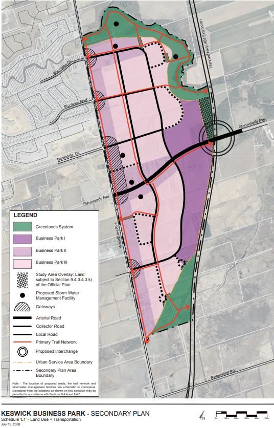
Figures
Figure 2-1: Keswick Land Use Plan (Schedule F-1), Keswick Secondary Plan ........................................... 8
Figure 2-2: Provincial Highway Extensions (Proposed)............................................................................. 9
Figure 2-3: York Region Transit Routes, Serving Keswick ....................................................................... 10
Figure 2-4: Town of Georgina Municipal Structure Map (Schedule A1), Official Plan ........................... 12
Figure 3-1: Urban Centres in Keswick Secondary Plan ........................................................................... 18
Figure 4-1: Trade Area ............................................................................................................................ 23
Figure 5-1: Population: Historic and Current (2006-2019) ..................................................................... 26
Figure 5-2: Population: Current and Forecasted (2019-2036)................................................................ 27
Figure 5-3: Estimated Seasonal Population, Trade Area ........................................................................ 27
Figure 5-4: Per Capita Income in 2015, Town of Georgina and Keswick ................................................ 28
Figure 6-1: Retail Inventory Summary, Study Area (July 2019) .............................................................. 33
Figure 6-2: Retail Inventory by Store Type, Study Area (July 2019) ....................................................... 35
Figure 6-3: Food Store Retail Facilities, Study Area ................................................................................ 36
Figure 6-4: Supermarkets in the Study Area ........................................................................................... 36
Figure 6-5: Non-Food Store Retail Facilities, Study Area ........................................................................ 37
Figure 6-6: Service Commercial Facilities, Study Area ............................................................................ 38
Figure 6-7: Commercial Development Applications, Study Area ........................................................... 39
Figure 6-8: Summary of Proposed Commercial Development Applications, Study Area....................... 40
Figure 6-9: Potential Commercial Space in the Study Area .................................................................... 41
Figure 6-10: Existing Vacant Land in the Study Area .............................................................................. 42
Figure 7-1: Study Area Per Capita Commercial Needs Analysis (2019) .................................................. 49
Figure 8-1: Land Use and Transportation Map (Schedule L1), Keswick Business Park........................... 54
Keswick Secondary Plan – Commercial & Employment Land Analysis (Town of Georgina, Ontario)   |   1

1.0 Introduction
2   |   Keswick Secondary Plan – Commercial & Employment Land Analysis (Town of Georgina, Ontario)

1.1 Background
The Planning Partnership, BA Group, Plan B Natural Heritage, and urbanMetrics inc. (“urbanMetrics”)
have been retained by the Town of Georgina to undertake a review of the Keswick Secondary Plan
(herein referred to as “KSP”). urbanMetrics role in this assignment involves a review of the
commercial components of the Secondary Plan. The key questions to be addressed by this study are:

    •   How much commercial space and land is required to support the projected population of the
        Secondary Plan to 2041?
    •   What retail formats and types of commercial space will be required to serve the future
        Secondary Plan population?
    •   Where should future commercial space be located?
    •   What are the impacts of the development of the Keswick Business Park (“KBP”) on the need
        for commercial space in Keswick?
    •   What policies or policy modifications are required to ensure that commercial space best
        serves the needs of the Keswick community?
The following report details our approach and methodology, along with the findings and
recommendations of our commercial market assessment for the Keswick Secondary Plan Review
(KSPR).

1.2 Approach
The following outlines the various work steps that we have carried out in the completion of this
Commercial and Employment Land Analysis.

    •   Site and Access Evaluation
        This included a general review of the locational and transportation characteristics of the
        Keswick Secondary Plan Area (“Study Area”), including an assessment of the compatibility with
        surrounding land uses and the accessibility of potential commercial sites.

    •   Review of Policy Framework
        We have reviewed the existing policy framework in the Town of Georgina, focusing on the
        Official Plan policies, including the KSP and the Keswick Business Park Secondary Plan
        (“KBPSP”). The review has been used to identify the range of commercial designations, and the
        recommended areas where commercial development is encouraged.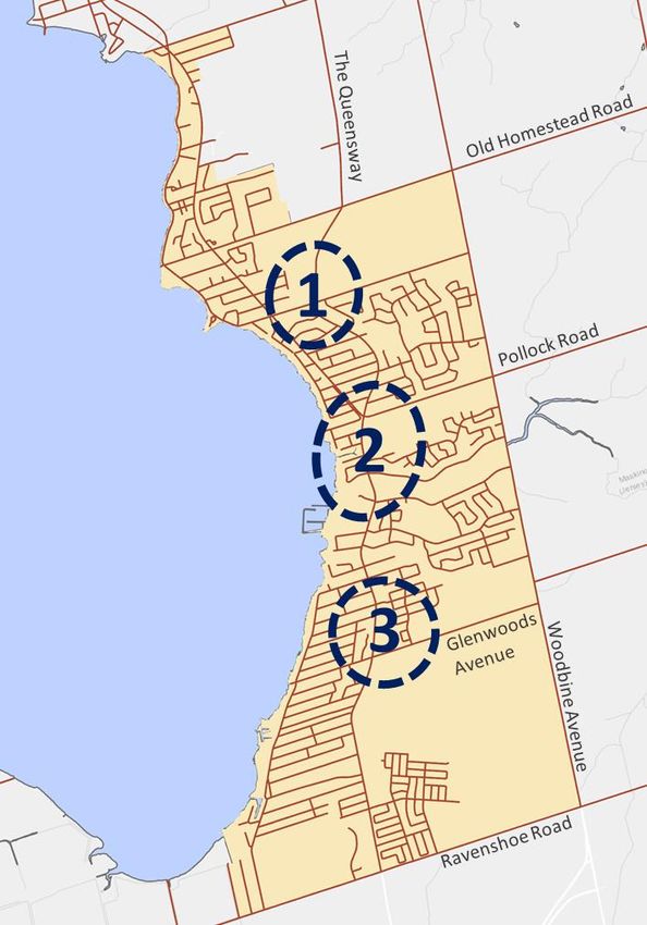
Keswick Secondary Plan – Commercial & Employment Land Analysis (Town of Georgina, Ontario)   |   3

•   Trade Area Delineation
    A Trade Area has been defined for the KSP based on a number of factors: accessibility, existing
    and future competition in the area, as well as the anticipated ability for retailers to attract
    customers outside of the immediate Study Area.
    A Trade Area represents the geographic area from which the majority (70% to 80%) of regular
    customer support would be derived. The remainder of customer support would come from
    employees working in the area, pass-by-traffic, and other non-residents. The Trade Area
    delineated by urbanMetrics has formed the basis of our commercial market analysis.
•   Market Dimensions of the Trade Area
    The population in the Trade Area has been determined for selected years of the study period
    to 2041. Historic population levels are based on Statistics Canada, from the 2006, 2011, and
    2016 Census. Future population levels are based on the most current official projections
    prepared for the Town of Georgina Development Charges Background Study, the Region of
    York Preferred Population Projections prepared in 2016, and have been confirmed by the
    Town of Georgina Planning staff. The future population in Keswick has been determined using
    the assumption that two-thirds of future growth in Georgina to 2041 will be attracted to
    Keswick. This is consistent with the assumptions used in the Keswick Development Charges
    Background Study.
•   Commercial Inventory
    In order to evaluate the existing competition in the KSP Area, an inventory of retail and service
    commercial space has been completed. The inventory included all food store retail (FSR), non-
    food store retail (NFSR), commercial services, and vacant space.
    In addition to our inventory of existing commercial space, we conducted a review of planned
    and proposed commercial developments in the KSP Area, which have been identified as future
    competition.
•   Commercial Market Opportunity Analysis
    A per capita analysis approach has been used to determine the amount of commercial space
    warranted as part of the Keswick Secondary Plan Review. Our analysis has examined the need
    for a range of retail and services space. Through this analysis, we have estimated the expected
    commercial space requirements of the local residents as the Trade Area builds out, as well as
    local capture rates, the extent to which existing space is supported by Trade Area residents,
    and inflow opportunities. The results of this analysis have been compared to the amount of
    existing, planned, and proposed commercial space in the Trade Area. Based on this analysis,
    we have determined if sufficient commercial designated lands have been allocated to the KSP
    Area to meet demands of local residents, or if the planned commercial space in the KSP Area
    will result in an oversupply or undersupply.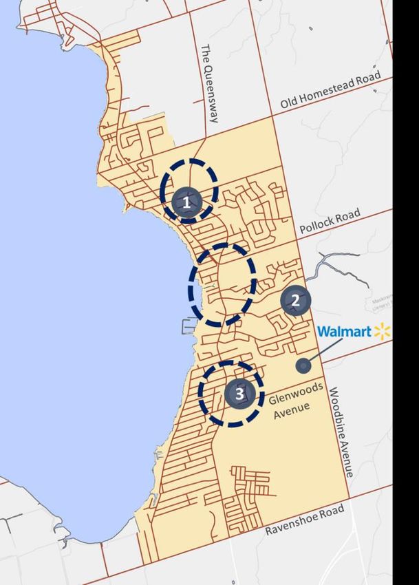
4   |   Keswick Secondary Plan – Commercial & Employment Land Analysis (Town of Georgina, Ontario)

    •   Employment Area Analysis
        The Keswick Business Park (KBP), although undeveloped, is now serviced and capable of being
        developed going forward. We have reviewed the KBPSP and employment projections for the
        Town of Georgina to understand how the development of this area will influence the need for
        future commercial uses in the rest of Keswick. We will consider both commercial uses – i.e.
        office uses and ancillary retail uses – that can be developed within the KBP, as well as, uses not
        permitted in the business park that may be supported by KBP businesses and their employees.

1.3 Assumptions
There are a number of underlying and basic assumptions upon which the validity of the findings
presented in this report depend. Based on our considerable and long-term experience in the retail
planning process, we recognize and appreciate the problems associated with making broad and
generalized assumptions about future conditions. Deviations from historical and current trends will
certainty take place in the future, however, basic assumptions are required regarding the possible
extent of such deviations.
These basic assumptions include:

    •   During the forecast period discussed in this report, a reasonable degree of economic stability
        will prevail in the Province of Ontario, the Town of Georgina, and specifically in Keswick;

    •   Estimates of future population growth in the Trade Area are assumed to be sufficiently
        accurate and are based on our review of Statistics Canada data, as well our review of relevant
        publications produced for the Town of Georgina and Keswick;

    •   The official statistical sources utilized in this report (based largely on Statistics Canada
        publications) are considered sufficiently accurate for the purposes of this analysis;

    •   The year 2019 has been assumed as the base year in our analysis;

    •   References to the Canadian dollar in this report, dealing with present and future periods,
        reflect its 2019 value. We recognize that fluctuation in the absolute value and purchasing
        power of the dollar will likely occur during the period covered by this report. We assume,
        however, that the relationship between per capita income and expenditure levels and the
        value of the dollar will remain more or less constant during the period analyzed. Since this
        report deals with future space additions, inflation has been eliminated since it has no
Keswick Secondary Plan – Commercial & Employment Land Analysis (Town of Georgina, Ontario) | 5
influence on the physical space used in retail facilities. However, real growth (excluding
inflation) in expenditures has been acknowledged in the analysis.
If, for any reason, major changes occur which could influence the basic assumptions stated above, the
recommendations contained in this report should be reviewed in light of such changed conditions and
revised, if necessary.6 | Keswick Secondary Plan – Commercial & Employment Land Analysis (Town of Georgina, Ontario) 2.0 Keswick Study Area
Keswick Secondary Plan – Commercial & Employment Land Analysis (Town of Georgina, Ontario)   |   7

 Key Findings
    o   The Study Area is the Keswick Secondary Plan Area (“Keswick”). Keswick is the largest urban
        community in the Town of Georgina and is anticipated to attract approximately two-thirds
        of the population growth for the Town as a whole over the next 20 years.
    o   Keswick has seen a significant boost to its regional accessibility with the expansion of
        Highway 404 to Ravenshoe Road. The planned Highway 404 extension to Highway 12 and
        the planned Bradford By-Pass would further enhance the accessibility of the community.
        With continued housing price escalation in the GTA, Keswick is well positioned to
        accommodate future housing and business growth.
    o   Owing to restrictive commercial land use permissions in the KBP, there would be minimal
        competitive overlap with the commercial uses that could be accommodated within the
        business park and those that would be required to serve the broader Keswick Community.
        This overlap would be limited to office uses that might otherwise locate in retail centres
        (e.g. real estate, financial, insurance and similar local serving offices) and ancillary retail and
        services that could be part of business park office buildings.

2.1 Location Characteristics
The Keswick Secondary Planning Area, herein referred to as the “Study Area”, is located on the
western edge of the Town of Georgina. The Study Area is approximately 16.25 square kilometres and
is bordered by Woodbine Avenue to the east, Ravenshoe Road to the south, Cook’s Bay shoreline to
the west, and a combination of Boyers Road and Old Homestead Road to the north. The land use
structure and boundary of the Study Area is detailed in Figure 2-1.
Keswick is the largest urban community in the Town of Georgina. The established area has a wide
range of residential, commercial, institutional, and recreational offerings; and has continued to evolve
into a well-balanced community for residents.
8 | Keswick Secondary Plan – Commercial & Employment Land Analysis (Town of Georgina, Ontario) Figure 2-1: Keswick Land Use Plan (Schedule F-1), Keswick Secondary Plan Source: Town of Georgina Access to Transportation and Mobility Network The community of Keswick is still heavily oriented to automobile travel. While York Region Transit does operate two bus routes through the community, for the most part distances between residential areas and other destinations are significant and densities are too low to support extensive active transportation. The 2016 Transportation for Tomorrow Survey indicated that on a daily basis, between 85% and 90% of trips by Keswick residents were as a driver or passenger in a private vehicle.
Keswick Secondary Plan – Commercial & Employment Land Analysis (Town of Georgina, Ontario)   |   9

In late 2014, the Highway 404 extension from Green Lane to Ravenshoe Road was completed. This
infrastructure investment created a direct highway connection between Keswick and major
municipalities to the south, including Newmarket, Markham, Richmond Hill, and Toronto. There are
long-term proposals that call for Highway 404 to be further extended to Highway 12, near the
community of Beaverton.
The 404 extension to Ravenshoe Road will help to accelerate both residential and non-residential
growth in Keswick, although it may also make competing commercial facilities in Newmarket more
accessible to local residents. The extension northeast towards Beaverton would enhance the
accessibility of Keswick commercial facilities to the communities to the east which have more limited
commercial opportunities.
Additionally, Keswick would benefit from the Bradford By-Pass, which has been recently ‘green-
lighted’ by the provincial government. This route would serve as a connector between Highway 400
and Highway 404 near the southern edge of Georgina. As with the Highway 404 extension, the
Bradford By-pass will enhance the accessibility and attractiveness of Keswick as a place to live and
locate a business. Figure 2-2 illustrates the location of both proposed highway extensions.

Figure 2-2: Provincial Highway Extensions (Proposed)

Source: York Region
10   |   Keswick Secondary Plan – Commercial & Employment Land Analysis (Town of Georgina, Ontario)

The local public transportation for the Keswick population is provided by York Region Transit. As
shown in Figure 2-3, there are two primary routes – Route 50 and Route 51 – that serve local
residents and employees. Route 50 serves The Queensway and Metro Road North corridor, while
Route 51 has a more complex route that connects Ravenshoe Road and Woodbine Avenue to most of
the commercial and residential nodes in Keswick. In 2015, average daily ridership for the routes along
The Queensway and Woodbine Avenue was estimated at 1000-5000 people per day. According to
the 2016 Transportation for Tomorrow survey, only between 2% to 3% of daily trips by Keswick
residents involve local transit.

Figure 2-3: York Region Transit Routes, Serving Keswick

Source: York Region Transit
Keswick Secondary Plan – Commercial & Employment Land Analysis (Town of Georgina, Ontario)   |   11

The Study Area is additionally served by a GO Transit bus route (Route 67) that has a terminus station
where Highway 404 meets with Woodbine Avenue just south of Ravenshoe Road. The route is
primarily a commuter route for Keswick residents, as it only departs from Keswick in the morning, and
returns in the evening. The route terminates at Finch Station Bus Terminal; however, it contains stops
along Highway 404 in Newmarket, Aurora, Markham, and the Sheppard Subway Station. In addition,
the closest GO Train station is approximately 20 kilometres to the south in East Gwillimbury.
According to the 2016 Transportation for Tomorrow Survey, GO Transit serves only a very small
portion of commuting trips by Keswick residents.

2.2 Surrounding Communities
As illustrated in Figure 2-4, the Study Area is situated on the western edge of the Town of Georgina.
Georgina is a traditionally rural community comprising a variety of small settlement areas, recreation
uses along the lakeside and protected environmental and agricultural areas. Keswick is the largest
and fastest growing settlement area in the Town, although Sutton/Jackson’s Point to the northeast is
also experiencing some development pressure.
12 | Keswick Secondary Plan – Commercial & Employment Land Analysis (Town of Georgina, Ontario)
Figure 2-4: Town of Georgina Municipal Structure Map (Schedule A1), Official Plan
Source: Town of Georgina
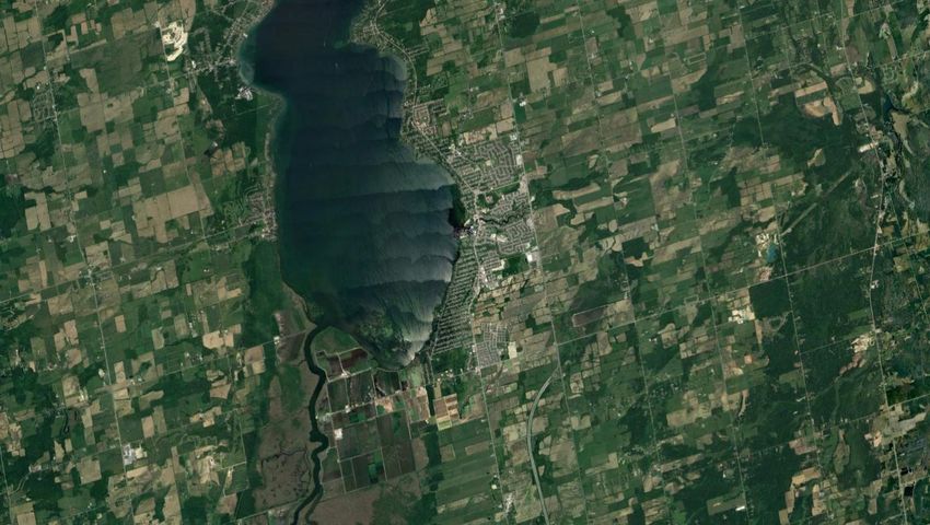
• To the West – situated immediately west of the Keswick is Cook’s Bay, the southernmost bay
of Lake Simcoe. Keswick is the largest community on the shores of Cook’s Bay, and has
multiple marinas and related facilities located along the shoreline. The largest marina in
Keswick is Krate’s Marina. The bay is popular in winter and summer for a variety of outdoor
recreation opportunities, including fishing, ice-fishing, swimming, and windsurfing.
Unfortunately, virtually all of the shoreline in Keswick is under private ownership – mostly by
permanent and seasonal residents, which limits the opportunity for additional lake-based
tourism commercial opportunities.
• To the North – the area situated directly north of the Study Area is designated as and occupied
by a variety of low intensity land uses; including Serviced Lakeshore Residential Area along
Lake Drive North, Orchard Beach Golf Course on Commercial Recreation land, and a
combination of Environmental and Agricultural Protection Areas (The Greenbelt). The
protected areas were defined as part of the Greenbelt Act in 2005. The Greenbelt wasKeswick Secondary Plan – Commercial & Employment Land Analysis (Town of Georgina, Ontario) | 13
established to protect green space, farmland, communities, forests, wetlands, and watersheds
in Ontario’s Greater Golden Horseshoe. Permanent and seasonal residents to the north of
Keswick would be dependent on Keswick for a large share of their commercial needs.
• To the East – the lands to the east of the Study Area (Woodbine Avenue) are primarily
protected by the Greenbelt as Environmental and Agricultural Protection Areas. Additionally,
the area features a variety of watercourses that lead to Cooks Bay. There are a few exceptions
along Woodbine Avenue whereby parcels of land are designated as Rural Industrial or Rural
Commercial Areas. Despite being currently undeveloped, the lands east of Woodbine Avenue
generally between the Maskinonge River and Ravenshoe Road are reserved for the KBP. The
KBP is estimated to be 113.87 hectares in total, with 89.40 hectares of industrial designated
lands. Further east, there are a variety of communities which accommodate permanent
residents, seasonal residents and tourism uses. Lands on the south shore of Lake Simcoe
contain a number of public beaches, as well as accommodations and recreation properties,
which attract visitors from across the Region. Keswick represents the largest commercial focal
point for the Georgina communities to the east.
• To the South – the lands to the south of the Study Area are located in the Municipality of East
Gwillimbury and are primarily protected by the Greenbelt, with a few site-specific exemptions.
Further south in south East Gwillimbury and northern Newmarket are a number of major
commercial uses that would attract spending from Keswick residents. These would include
large format retail uses in the vicinity of Green Lane and Yonge Street, Upper Canada Mall and
additional retail uses along Yonge Street and Davis Drive in Newmarket.14 | Keswick Secondary Plan – Commercial & Employment Land Analysis (Town of Georgina, Ontario) 3.0 Land Use Policy Context
Keswick Secondary Plan – Commercial & Employment Land Analysis (Town of Georgina, Ontario)   |   15

 Key Findings
    o   There are five land use designations that can accommodate future commercial development
        within the Study Area.
            •    Commercial/Employment Area on the west side of Woodbine Avenue – These lands
                 comprise some 316 acres (127 hectares), of which 207 acres (83 hectares) are vacant
                 and are intended for large scale retailing that relies on arterial road access and a
                 range of prestige industrial uses. This designation permits a very broad range of
                 commercial and prestige industrial uses.
            •    Urban Centres – Three Urban Centres are designated to encourage mixed-use
                 development at strategic locations. Commercial uses in these areas generally support
                 local shopping. Available site sizes would generally limit the size of uses that could be
                 accommodated within the Urban Centres.
            •    Urban Corridors – Two Urban Corridors are designated along the Queensway to
                 connect the Urban Centres. Commercial uses are permitted, however, there is limited
                 land availability to accommodate future commercial space in the corridors.
            •    Neighbourhood Centres – Neighbourhood Centres can be designated in residential
                 areas to provide for a 5 to 10 minute walk of convenience retail and services. These
                 are intended to be small sites. There are no vacant Neighbourhood Centre sites at
                 present.
            •    Tourist Commercial – This designation exists to recognize individual tourist
                 commercial properties outside of established commercial areas. There is only one
                 very small site of vacant land with this designation in Keswick

In order to help determine the most appropriate land uses designations, formats and functions for
commercial space in the KSP, we have reviewed and provided an overview of existing commercial
policies. In the following subsections we have summarized the KSP’s commercial policies relating to
Urban Centres and Urban Corridors, as well as other areas within the municipal structure that permit
commercial uses.

3.1 Commercial/Employment
To support the growing population and employment base within the Study Area, the Town of
Georgina has designated a large portion of the west side of Woodbine Avenue as a
“Commercial/Employment” area. The corridor is generally located between Old Homestead Road and
16 | Keswick Secondary Plan – Commercial & Employment Land Analysis (Town of Georgina, Ontario) Ravenshoe Road, and comprises the most accessible lands in the community, including: frontage on Woodbine Avenue, proximity to Highway 404, and well positioned to serve existing residential areas and the future KBP. There is a total of 315 acres (127 hectares) of designated Commercial/Employment land in Keswick, and the entirety of it is located along Woodbine Avenue. Of this, some 207 acres (83 hectares) are vacant. About 60% is south of Glenwoods Avenue and is distributed over 3 large properties. Within the Commercial/Employment designation, the following uses are permitted: retail and service commercial uses; business and professional offices; institutional and community uses; industrial mall complexes and prestige industrial uses including any manufacturing or industrial use which is contained within a wholly enclosed structure and which is not an obnoxious use, with accessory office and associated retail; public and private recreation/community complexes including movie theatres, bowling alleys, athletic clubs and athletic facilities; building supply outlets; hotels and motels; and, auto service stations and automobile dealerships, only in a campus setting. The Commercial/Employment designation encourages medium-density development, whereby maximum building heights shall be generally four storeys, and mixed-use office and commercial buildings can be up to six storeys. Further, to encourage residents and employees to commute and travel by sustainable modes of transportation, the Commercial/Employment designation requires all new development to provide convenient access and integration with active transportation infrastructure. The Commercial/Employment Area is the location of a number of major commercial uses, which serve a broad area, including: Walmart Supercentre, Canadian Tire, Zehrs Markets, and Staples, as well as, a variety of other retail uses. It also contains the largest vacant commercial land supply in the community and would be well positioned to attract the largest share of future commercial space required to serve new growth in Keswick. 3.2 Urban Centres To promote the appropriate development and distribution of commercial space across Keswick, the KSP designates three Urban Centres located along The Queensway. Urban Centres are considered key components of the community’s structure, and are intended to provide opportunities to create a distinct character for Keswick. Urban Centres are intended to be developed as mixed-use districts with a variety of uses, retail formats, and densities. The vision of growth for the three Centres include high density and taller buildings that are located close to arterial roads for pedestrian access, high quality urban design features, and retail/service commercial uses located on the ground floor of mixed-use projects. Single-use buildings and parking in front of buildings are not encouraged. In total, there are 282 acres
Keswick Secondary Plan – Commercial & Employment Land Analysis (Town of Georgina, Ontario)   |   17

(114 hectares) of land that permit commercial uses in the Urban Centres. Of this total, some 26 acres
(10 hectares) are vacant.
As shown in Figure 3-1, the three Urban Centres include Uptown Keswick, Maskinonge, and
Glenwoods. All are located on The Queensway, a primary arterial route through Keswick for residents.
As stated in the Town of Georgina’s Transportation Master Plan and the 2015 Annual Daily Traffic
Report, The Queensway is identified as a regional road that an estimated 10,000 to 25,000 persons
use per day.
For the most part, the Urban Centres function to provide commercial uses and services to their
surrounding neighbourhoods. This is in contrast to the Commercial/Employment designated lands
west side of Woodbine Avenue which contain a number of larger scale retail uses that serve a Town-
wide or more regional serving function. The Urban Centres are also well positioned to support
intensification within the centres themselves or along the nearby Urban Corridors.
18 | Keswick Secondary Plan – Commercial & Employment Land Analysis (Town of Georgina, Ontario)
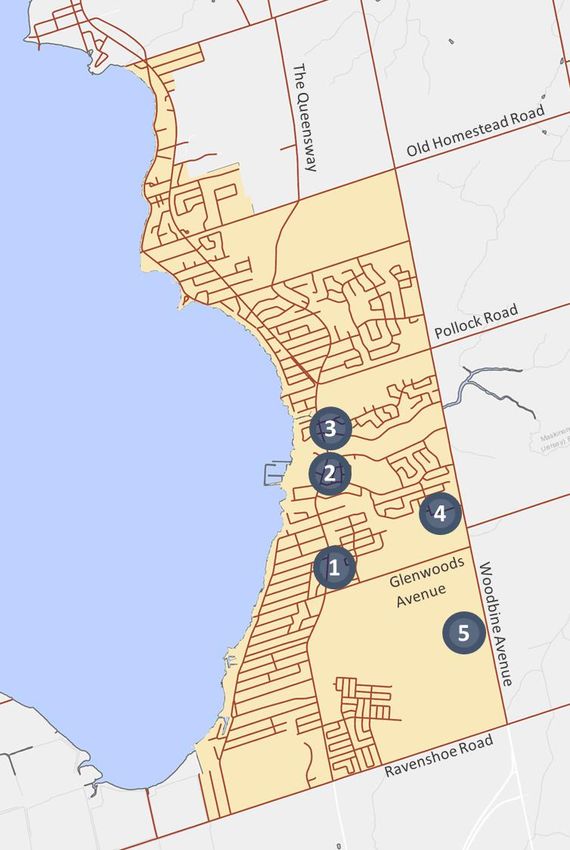
Figure 3-1: Urban Centres in Keswick Secondary Plan
1. Uptown Keswick Urban Centre
Commercial properties in this urban
centre are primarily strip retail or along
moderately walkable main streets. The
node has predominantly service-related
tenants. Total retail space amounts to
some 122,300 square feet, around 12% of
Keswick’s total retail supply.
2. Maskinonge Urban Centre
Commercial development in this node is
meant to integrate small-scale retail with
the Lake Simcoe shoreline, into a
tourism-commercial, recreation, and
mixed-use area. Currently the urban
centre has predominantly service-related
tenants and 10% of Keswick’s retail
space, amounting to some 105,000
square feet.
3. Glenwoods Urban Centre
This area accounts for 20% of total retail
space (211,100 square feet), and is
intended to function as a retail node that
supports residents in South Keswick.
Major retail centres include Glenwoods
Centre, and the Queensway Medical
Centre. This node has the most vacant
Source: urbanMetrics inc.
space out of all three urban centres.
There is some 26 acres (10 hectares) of vacant commercial land in these urban centres.
Approximately 20 acres (8 hectares) of which is contained in a single site at the south end of the
Glenwoods Urban Centre. This land or a portion of it could support local serving uses to support
future population growth in south Keswick. The majority of the remaining vacant land in the Urban
Centres is comprised of several smaller parcels within the Maskinonge Urban Centre. These parcels
are generally small and some have constraints that may make commercial development difficult. One
is currently used for marina boat storage. These parcels would likely be suitable for some commercial
space as part of future infill development.
There is only one very small vacant site in the Uptown Keswick Urban Centre, situated between two
residential dwellings, one of which is being used for a commercial office.Keswick Secondary Plan – Commercial & Employment Land Analysis (Town of Georgina, Ontario) | 19 3.3 Urban Corridors The KSP recommends that transit supportive and higher density forms of development will be concentrated along “Urban Corridors” – the interstitial areas that connect the three Urban Centres along The Queensway. Urban Corridor 1, which connect the three Urban Centres is largely built out by low density residential uses. Commercial uses are limited only to where current zoning permits them, which amounts to 30 acres (12 hectares) in total, of which 5 acres (2 hectares) are vacant. This is mainly concentrated in a single site across The Queensway from the Stephen Leacock Theatre. This site would be difficult to develop entirely as commercial, as it has only a small frontage on the Queensway and the lands in the back are surrounded by low density residential uses and a public school. The Urban Corridor 2 designation, which extends south along the Queensway between the Glenwoods Urban Centre and Ravenshoe Road, permits retail and service commercial uses, as well as business and professional offices and sits adjacent to large tracts of future development land. Urban Corridor 2 contains 42 acres (17 hectares) of commercial land, which is comprised of a range of sporadically spaced uses, including commercial plazas, individual commercial uses, a service centre and other automotive uses. There is one vacant site of approximately 1 acre (0.4 hectare). 3.4 Neighbourhood Centres Neighbourhoods are predominantly low-density residential areas built around common focal points called “Neighbourhood Centres”. Neighbourhoods Centres are intended to be positioned within a 5 to 10 minute walking distance for the residents which it serves. Convenience stores and personal services are permitted to provide a day-to-day service that encourages residents to walk or cycle for basic goods. Neighbourhood Centres would function at the lowest end of the retail hierarchy providing for very localized convenience-oriented shopping. There are currently no available sites for additional Neighbourhood Centres, although these could be designated as part of a residential subdivision plans. 3.5 Tourist Commercial The Town of Georgina has designated a collection of parcels along the shoreline of Cook’s Bay as Tourist Commercial. Under this designation, the following commercial uses are permitted: hotels, motels, marinas, souvenir stores, boat sales and rentals, bait and tackle stores, marine equipment sales, and other similar tourist oriented commercial uses. The designation also allows for medium density residential development if it is part of a comprehensive tourist commercial development.
20   |   Keswick Secondary Plan – Commercial & Employment Land Analysis (Town of Georgina, Ontario)

The total 8.76 acres of designated Tourist Commercial land is used to recognize individual existing
tourist related properties, such as marinas, a motel, and a waterfront pub/restaurant, outside of
other commercially designated lands. This land use designation is not a land use category containing
vacant land capable of supporting new development. Currently, there is only one small (0.17 acre or
0.06 hectare) tourist commercial site that is vacant.
In addition to commercial and employment uses, the west side of Woodbine Avenue is the home of
the Georgina Ice Palace/Georgina Library towards the northern part of Keswick and will be home to
the new Multi-Use Recreation Centre towards the south end between Glenwoods Avenue and
Ravenshoe Road. These two important recreational complexes will also draw persons to the area and
assist in anchoring the retail cluster along Woodbine Avenue.
Keswick Secondary Plan – Commercial & Employment Land Analysis (Town of Georgina, Ontario)   |   21

4.0 Trade Area
22   |   Keswick Secondary Plan – Commercial & Employment Land Analysis (Town of Georgina, Ontario)

 Key Findings
     o    The Trade Area served by the commercial facilities within the Keswick Secondary Plan Area
          (Study Area) has been defined as the Town of Georgina.
     o    To the north and west, driving distances to Keswick are impeded by Lake Simcoe. To the
          south, the significant commercial competition in Newmarket and the Green Lane Area of
          East Gwillimbury would limit shopping by persons from south of the Town. To the east,
          beyond the Town boundary, the Town of Uxbridge would be a more convenient shopping
          destination.
     o    In addition to persons living in the Town of Georgina, additional expenditure potential
          would be available from inflow, including: tourists, seasonal residents, non-residents
          working in Georgina; and transient traffic.

4.1 Trade Area Delineation
The total market influence attributed to a commercial concentration typically extends over a wide
area beyond any precise boundary that can be drawn. In many cases, the shopping environment,
competition, anchor tenants, and the range of goods and services offered in a commercial
development will affect the extent of this market influence. However, for the purpose of making
reliable estimates of available market support, a specific Trade Area has been defined. The Trade Area
represents the geographic area from which proposed commercial facilities in the Study Area are likely
to generate the majority of their customer support.
The delineation of the Trade Area was based on a number of factors, including:

     •   The existing market influence of competitive retail/service commercial facilities located near
         Keswick and elsewhere in the Town of Georgina;
     •   Distance and travel times to the area from various locations in the municipality;
     •   Local and regional access characteristics of the area; and,
     •   The location of natural and man-made barriers which could restrict the movement of
         customers to and from the area.
Commercial facilities in Keswick face their most direct competition from the retail uses on Green
Lane, Yonge Street and Davis Drive in Newmarket and East Gwillimbury. The extent of retail facilities
in this area is far beyond what would be required to serve the local population and indicate that these
facilities also serve a regional base. As a result, the southern boundary of the Keswick Trade Area
would be severely constrained by this commercial concentration. Travel towards the west is difficult
owing to the lack of connecting points over Cooks Bay and the Holland Marsh. To the north and east,
Keswick Secondary Plan – Commercial & Employment Land Analysis (Town of Georgina, Ontario) | 23 there is limited commercial competition until Highway 12 whereby the commercial draw of Uxbridge, Orillia and southern Durham Region becomes more influential. Based on the factors considered above, it is our professional opinion that the municipal boundaries of the Georgina form the appropriate Trade Area for retail/service commercial facilities in the Study Area. As illustrated in Figure 4-1, the Trade Area encompasses the built-up area of Keswick, and extends to include the communities of Sutton, Jackson’s Point, Pefferlaw, Udora, as well as the surrounding rural areas and villages along Lake Simcoe. Although commercial facilities located in Keswick are expected to derive a significant portion of its sales volume from the expenditures made by the Trade Area residents, it is important to note that additional market support will ultimately result from expenditures made by non-Trade Area residents as well (e.g., local employees, seasonal residents, tourists, and other visitors). These expenditures represent “inflow” sales, which will be appropriately recognized in our detailed retail market analysis that follows as part of our comprehensive market demand study. Figure 4-1: Trade Area Source: urbanMetrics inc.
24   |   Keswick Secondary Plan – Commercial & Employment Land Analysis (Town of Georgina, Ontario)

5.0 Market Characteristics
Keswick Secondary Plan – Commercial & Employment Land Analysis (Town of Georgina, Ontario)   |   25

 Key Findings
    o   The base year (2019) population of the Town of Georgina and Keswick has been estimated
        at 48,415 and 28,604 respectively. Between 2019 to 2041, Keswick will account for 66% of
        total growth within the Town; amounting to over 15,000 new residents within this period.
    o   The Town’s seasonal population is estimated at 4,649 persons in 2019, approximately 10%
        of the total population. We have assumed that this modest seasonal population will not
        have a significant impact on inflow for retail and non-retail facilities.
    o   The average per capita income in the Town of Georgina is nearly 25% below the Provincial
        average. The average Keswick income is slightly above that for the Town as a whole, but still
        over 20% below the Provincial average.
    o   The Construction and Retail Trade industries employ the largest number of Georgina
        residents, with Manufacturing and Health Care/Social Assistance following closely behind.

This section provides a detailed overview of the population, per capita income and other
demographic characteristics of the Keswick Secondary Plan Area and the Town of Georgina as a
whole, which will serve as important inputs to our commercial market demand analysis to be
completed in subsequent phases of this study.
It is important to note that Schedule 3 of the Growth Plan outlines a distribution of population and
employment forecasts to 2041, and York Region is currently undertaking a Municipal Comprehensive
Review (MCR) that includes population and employment forecasts for the Town of Georgina. We note
that these forecasts may potentially conflict with the Town of Georgina’s 2016 Development Charge
Bylaw Study, prepared by Hemson Consulting, which has been used in support of the growth forecasts
included in this study.

5.1 Population & Residential Growth
Historic and Current Population
Figure 5-1 details the historic and current population for the Town of Georgina (Trade Area) and the
Keswick Secondary Plan Area. (Study Area). Historical populations have been based on Statistics
Canada Census data, adjusted for net undercoverage. The Trade Area saw modest population growth
of some 4,211 persons between 2006 to 2019. The majority of this growth was located in Keswick –
approximately 96% - amounting to 4,050 residents. Due to this growth, the Study Area saw an annual
26 | Keswick Secondary Plan – Commercial & Employment Land Analysis (Town of Georgina, Ontario)
growth rate of 1.3% within this period, compared to 0.7% for the entire Trade Area. According to
population forecasts commissioned by the Region of York, the base year population for the Trade
Area was estimated at 48,415 on July 30, 2019, of which an estimated 28,604 persons reside in the
Keswick Study Area. The detailed historic and projected population and employment growth for
Keswick and the Town of Georgina has been included in Appendix A and B.
Figure 5-1: Population: Historic and Current (2006-2019)
Historical Base Year Period Growth
2006 2011 2016 2019 2006 - 2019
1 1 1 2
Town of Georgina 44,204 44,906 47,373 48,415 4,211
Annual Growth 140 493 347 324
Annual Growth Rate 0.3% 1.1% 0.7% 0.7%
1 1 1 3
Keswick 24,554 26,832 27,909 28,604 4,050
Annual Growth 456 215 232 312
Annual Growth Rate 1.9% 0.8% 0.8% 1.3%
Source: urbanMetrics inc., based on the following data sources:
1
Census of Canada – Adjusted for Census Undercount.
2
York Region Population Estimate June 30, 2019 based on housing completions – Adjusted for Undercount.
3
Based on Keswick share of Georgina population growth of 66% as per Town of Georgina 2016 DCBS Study.
Projected Population Growth
Future projections for the Town of Georgina and Keswick have been based on the existing population
and the projected growth forecasts in the Town of Georgina Development Charges Background Study
(DSBS), completed by Hemson Consulting in April 2016. Once adjusted for undercoverage, forecasts
indicate that the Trade Area population will grow at an average annual rate of 2.1%, adding 22,885
new residents between 2019 to 2041. Within the same period, Keswick is estimated to grow by
15,257 residents. The future Keswick population is based on share of growth percentages included in
the Hemson study, which indicate that 66% of new growth will be located in Keswick.Keswick Secondary Plan – Commercial & Employment Land Analysis (Town of Georgina, Ontario) | 27
Figure 5-2: Population: Current and Forecasted (2019-2036)
Base Year Forecast Period Growth
2019 2021 2026 2031 2036 2041 2019 - 2041
1 2 2 2 2 3
Town of Georgina 48,415 50,882 54,352 58,923 66,082 71,300 22,885
Annual Growth 1,234 694 914 1,432 1,044 1,039
Annual Growth Rate 2.5% 1.4% 1.7% 2.4% 1.6% 2.1%
4 4 4 4 4 4
Keswick 28,604 30,248 32,562 35,609 40,382 43,860 15,257
Annual Growth 822 463 609 955 696 693
Annual Growth Rate 2.9% 1.5% 1.9% 2.7% 1.7% 2.4%
Source: urbanMetrics inc., based on the following data sources:
1
York Region Population Estimate June 30, 2019 based on housing completions – Adjusted for Undercount.
2
Town of Georgina 2016 DCBS – Adjusted for Undercount.
3
York Region Preferred Growth Scenario, November 2015 – Adjusted for Undercount.
4
Based on Keswick share of Georgina population growth of 66% as per Town of Georgina 2016 DCBS.
Seasonal Population
It is important to note that the population growth forecasts for the Trade Area do not include
population in unoccupied dwellings such as second/seasonal residences. In many municipalities in the
Greater Golden Horseshoe (GGH), which are subject to the Growth Plan, only a small portion of
dwellings are occupied as second/seasonal homes. However, the seasonal population in Georgina is
modestly more significant as the Town is bordered by Cook’s Bay and Lake Simcoe; both of which are
attractive to cottagers, boaters, cyclists, and outdoor recreation enthusiasts.
According to information retrieved from the Town of Georgina’s Tax and Water Utilities division,
there are 1,722 seasonal dwelling units located in the Town of Georgina (Trade Area) as of December
2019. As shown in Figure 5-3, the estimated seasonal population is 4,649 persons – approximately
10% of the Trade Area’s 2019 population.
Figure 5-3: Estimated Seasonal Population, Trade Area
TRADE AREA
1
Seasonal Dwellings 1,722
2
Persons Per Unit (PPU) 2.70
Estimated Seasonal Population 4,649
Source: urbanMetrics inc.
1
Town of Georgina Tax and Water Utilities Division, December 2019.
2
Town of Georgina Development Charges Background Study (2016)28 | Keswick Secondary Plan – Commercial & Employment Land Analysis (Town of Georgina, Ontario)
5.2 Income
Per capita income levels provide a reasonable guide for determining the expenditure habits of the
local population living within a defined area. Although certain intervening variables, including age
and geographic location, can influence consumer expenditure habits and shopping preferences,
population groupings with similar income characteristics tend to exhibit similar expenditure habits for
broad merchandise groupings.
As shown in Figure 5-4, we have calculated the 2015 per capita income levels for Trade Area
residents. These calculations are based on 2016 Statistics Canada Census data.
Figure 5-4: Per Capita Income in 2015, Town of Georgina and Keswick
Town of
Georgina Study Area
2016 Population1 45,418 26,757
Males 15 years and over with income 17,620 10,575
Male average income $42,960 $43,550
Females 15 years and over with income 18,110 11,090
Female average income $28,748 $29,472
Total Income $1,277,581,480 $787,385,730
Average Per Capita Income $28,129 $29,427
Source: urbanMetrics, inc. based on 2016 Statistics Canada Census data
1
Excluding undercount.
The Town of Georgina had a per capita income level of $28,129 in 2015, while Keswick had a
moderately higher per capita income of $29,427. Both are more than 20% lower than the Provincial
average. The Construction and Retail Trade industries employ the largest number of Georgina
residents, with Manufacturing and Health Care/Social Assistance following closely behind.
Despite the Georgina’s weakness in attracting high-paying, highly-skilled jobs, the Town of Georgina
Economic Development Strategy and Action Plan note that 70% of Georgina’s employed labour force
work outside the community. This indicates that residents could be potentially commuting to higher
paying jobs in municipalities with significantly more office development and established companies –
including Markham, Richmond Hill, and Toronto. With the development of the KBP, both Keswick andKeswick Secondary Plan – Commercial & Employment Land Analysis (Town of Georgina, Ontario) | 29 the Town as a whole, have the potential to capture some of these commuters and create high-paying job opportunities; which could lead to an increased average per capita income in the future
30   |   Keswick Secondary Plan – Commercial & Employment Land Analysis (Town of Georgina, Ontario)

6.0 Commercial Competition
Keswick Secondary Plan – Commercial & Employment Land Analysis (Town of Georgina, Ontario)   |   31

 Key Findings
     o   The Study Area has a total of 1,046,700 square feet (97,241 square metres) of retail/service
         commercial space. Nearly 50% (496,200 square feet or 46,098 square metres) of the space is
         located along the Woodbine Avenue corridor. The majority of remaining space is generally
         located in the three Urban Centres.
     o   The retail/service commercial vacancy of the Study Area rate is 2%. This is below a healthy
         rate, and suggests that there may exist some unfulfilled demand at the present time.
     o   Over 40% of retail/service commercial space in the Study Area is Non-Food Store Retail, and
         nearly 70% of that space is located on the Woodbine Avenue Corridor. Services and Food
         Store Retail account for 40% and 16% of total space, respectively.
     o   The most significant competition for the Keswick retail sector is the commercial
         concentration existing at Green Lane and Yonge Street, and along Yonge Street and Davis
         Drive in Newmarket and East Gwillimbury. This cluster contains most of the major retail
         tenants operating in the GTA and would serve to attract spending from Keswick residents, as
         well as, limiting the retail draw of Keswick to the south.
     o   There are five commercial development applications proposed in the Study Area that
         collectively amount to 6,500 square metres (70,000 square feet) of GFA. Over 60% of the
         proposed space is located on the Woodbine Avenue Corridor. This is a relatively small
         amount given the existing inventory and the future growth potential of Keswick and the
         Town of Georgina.
     o   There is currently some 240 acres (97 hectares) of vacant commercially designated land, of
         which about 207 acres (83 hectares) is situated along the west side of Woodbine Avenue. A
         supply of 240 acres would accommodate some 2.6 million square feet (241,500 square
         metres) of retail space at traditional commercial densities. This is far in excess of what the
         future population of Keswick will require given the projected population to 2041.

An analysis of competitive commercial facilities is essential to understanding the roles and functions
that existing stores in the Study Area currently fulfill for residents and visitors, as well as the potential
competitive influences which could affect the market available for the proposed development.
An inventory of commercial space was conducted in the Study Area by urbanMetrics inc. in July 2019.
Our inventory included all food store retail (FSR), non-food store retail (NFSR), and service commercial
facilities. Based on the North American Industrial Classification System (NAICS), FSR and NFSR store
types include the following:
You can also read