ROCKY MOUNTAIN AREA FIRE WEATHER ANNUAL OPERATING PLAN - 2018 COLORADO - WYOMING - SOUTH DAKOTA - NEBRASKA - KANSAS
←
→
Page content transcription
If your browser does not render page correctly, please read the page content below
ROCKY MOUNTAIN AREA
    FIRE WEATHER
ANNUAL OPERATING PLAN
                         2018

       COLORADO - WYOMING -
 SOUTH DAKOTA - NEBRASKA - KANSAS

 Rocky Mountain Area Fire Weather Annual Operating Plan - 2018
                              1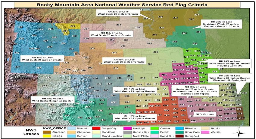
ROCKY MOUNTAIN AREA FIRE WEATHER ANNUAL OPERATING PLAN
                                  2018

SECTION                                                                             PAGE
I. INTRODUCTION                                                                        4
II. SIGNIFICANT CHANGES SINCE PREVIOUS PLAN                                            4

III. SERVICE AREAS AND ORGANIZATIONAL DIRECTORY                                        4

IV. NATIONAL WEATHER SERVICE SERVICES AND RESPONSIBILITIES                             9
      A. Basic Services                                                                9
             1. Routine Fire Weather Planning Forecast (FWF)                           9
             2. Spot Forecast                                                         12
             3. Red Flag Program                                                      14
             4. Experimental Grassland Fire Danger Index (GFDI)                       16
             5. NFDRS Forecast                                                        17
             6. Participation in Interagency Groups                                   17
      B. Special Services                                                             17
      C. Forecaster Training                                                          17
      D. Individual Forecast Office Information                                       17
             1. Northeast Colorado – Boulder, CO                                      17
             2. Southeast Colorado – Pueblo, CO                                       20
             3. Western Colorado – Grand Junction, CO                                 22
             4. Northern/Central/Southwest Wyoming – Riverton, WY                     24
             5. Big Horn NF, Recreation Area, and Sheridan County – Billings, MT      26
             6. Southeast Wyoming/Nebraska Panhandle – Cheyenne, WY                   28
             7. Northeast Wyoming/Western South Dakota – Rapid City, SD               29
             8. North Central/Northeast South Dakota – Aberdeen, SD                   31
             9. South Central/Southeast South Dakota – Sioux Falls, SD                33
             10. West Central/South Central Nebraska – North Platte, NE               34
             11. East Central Colorado/Northwest Kansas – Goodland, KS                36
             12. South Central Nebraska/North Central Kansas- Hastings, NE            37
             13. Southwest Kansas- Dodge City, Kansas                                 39
             14. Eastern Nebraska/Southwest Iowa- Omaha, Nebraska                     40
             15. Northeast Kansas- Topeka, Kansas                                     42
             16. Central/Southeast Kansas- Wichita, Kansas                            43
             17. Extreme Northeast Kansas- Pleasant Hill, Missouri                    45

                    Rocky Mountain Area Fire Weather Annual Operating Plan - 2018
                                                 2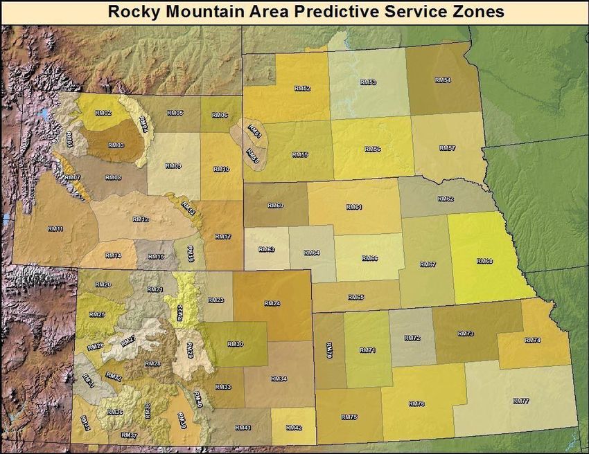
V. WILDLAND FIRE AGENCY SERVICES AND RESPONSIBILITIES 47
A. Predictive Services and Products 47
B. Program Management 48
C. Monitoring, Feedback and Improvement 48
D. Technology Transfer 49
E Agency Computer Systems 49
F. Fire Weather Observations 49
G. Technical Specialists 49
H. Reimbursement of NWS for on-site support and training assistance 49
I. Fuel Information Support 49
VI. JOINT RESPONSIBILITIES 50
A. Training 50
B. Incident Response 50
C. Briefings 51
D. Conference Calls 51
E. WIMS IDs for NFDRS Stations 51
F. NWSChat Coordination 51
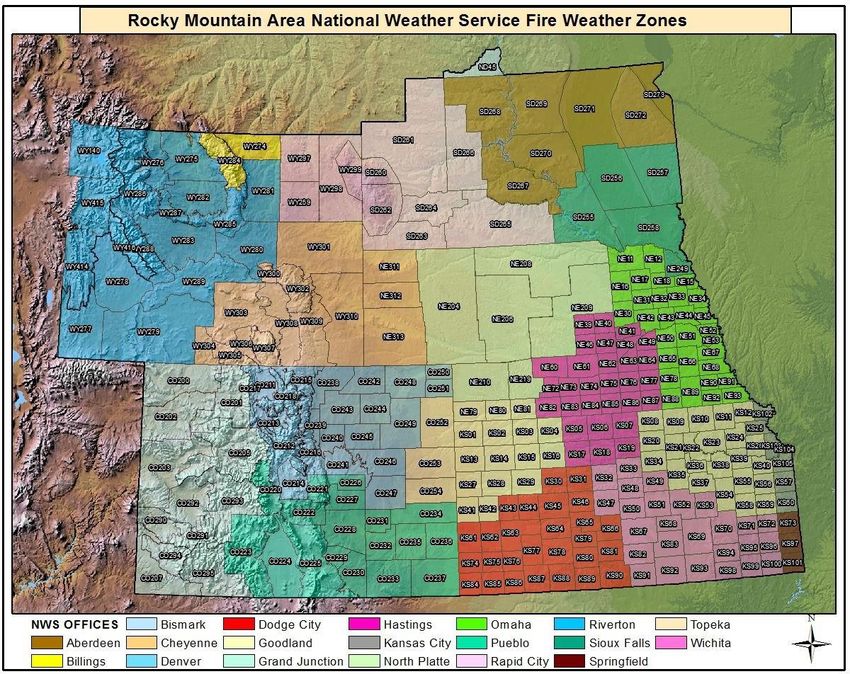
VII. RMA Predictive Service Area and NWS Fire Weather Zones 51
A. RMA Predictive Service Area Map 51
B. NWS Fire Weather Zone Map 52
VIII. Interagency Change of Service Procedures 52
IX. EFFECTIVE DATES OF AOP 53
X. AGENCY SIGNATURES 53
Rocky Mountain Area Fire Weather Annual Operating Plan - 2018
3
Rocky Mountain Area Interagency Fire Weather Operating Plan – 2018

 I.             INTRODUCTION

      This document serves as the Interagency Fire Weather Annual Operating Plan (AOP) for the Rocky
      Mountain Geographic Area. The general relationship between NWS and the interagency fire manageme nt
      community is set forth in the National Interagency Agreement for Meteorological Services. The AOP
      provides specific procedural and policy information about the responsibilities of both NWS offices and land
      management offices regarding meteorological services provided to the fire management community in the
      Rocky Mountain Area, as contained within the umbrella of the National Agreement.
      References will include:
        ● National Weather Service Directives NWSI 10-4: Fire Weather Services
        ● Interagency Agreement for Meteorological Services (National MOA or National
                    Agreement)
        ● Rocky Mountain Area and National Mobilization Guides

II.         SIGNIFICANT CHANGES SINCE LAST YEAR

       A. No significant changes have occurred since last year.

III.       SERVICE AREA AND ORGANIZATIONAL DIRECTORY

       A. Fire weather services in the Rocky Mountain Area are provided by the NWS
       forecast offices, RMA Predictive Services, and States listed below:
          Boulder, CO                     Riverton, WY                     North Platte, NE
          Pueblo, CO                      Rapid City, SD                   Goodland, KS
          Grand Junction, CO              Billings, MT                     Aberdeen, SD
          Cheyenne, WY                    Sioux Falls, SD                  Hastings, NE
          Omaha, NE                       Wichita, KS                      Topeka, KS
          Dodge City, KS                  Pleasant Hill, MO                Springfield, MO
          State of South Dakota           RMACC, Lakewood, CO

 ROCKY MOUNTAIN AREA PREDICTIVE SERVICES,
 2850 Youngfield St, Lakewood, CO 80215
 FAX Number: (888)850-2925
 Web Site Address: https://gacc.nifc.gov/rmcc
 Name                 Position                              Phone              E-M ail
 Tim Mathewson        Meteorologist / Program Manager       (303)   445-4309   t2mathew@blm.gov
 Russ Mann            Meteorologist / Asst. Met.            (303)   445-4308   rmann@blm.gov
 Marco Perea          Fire Intelligence Coordinator         (303)   445-4303   mperea@blm.gov
 Main Coordination    Center Number                         (303)   445-4300   CORMC@FIRENET.GOV

                           Rocky Mountain Area Fire Weather Annual Operating Plan - 2018
                                                        4
STATE OF SOUTH DAKOTA FIRE METEOROLOGIST,
South Dakota School of Mines & Technology, Department of Atmospheric Sciences,
501 East Saint Joseph Street, Rapid City, South Dakota 57701-3995
FAX (605) 394-6061
Web Site Address: http://www.ias.sdsmt.edu/clabo/index.htm

Name              Position                           Phone                    E-Mail
Darren Clabo      Fire Meteorologist                  (605) 394-1996          darren.clabo@sdsmt.edu
                                                      (605) 381-9253

BOULDER WEATHER SERVICE FORECAST OFFICE,
325 Broadway WS1, Boulder, Colorado 80305-3328
FAX Number: (303) 494-4409
Web Site Address: http://www.weather.gov/bou/fire
Backup Office: WFO Pueblo

Name              Position                               Phone               E-Mail
Lisa Kriederman   IMET/Fire Weather Program Leader       (303) 494-3877      lisa.kriederman@noaa.gov
Bernard Meier     Asst Fire Weather PL                   (303) 494-3877      bernard.meier@noaa.gov
Nezette Rydell    Meteorologist-ln-Charge                (303) 494-3877      nezette.rydell@noaa.gov

PUEBLO WEATHER SERVICE FORECAST OFFICE,
3 Eaton Way, Pueblo, Colorado 81001-4856
FAX Number: (719) 948-9729
Web Site Address: http://weather.gov/pub/fire
Backup Office: WFO Boulder

Name              Position                                Phone              E-Mail
Makoto Moore      IMET/Fire Weather Program Leader        (719) 948-3838     makoto.moore@noaa.gov
Eric Petersen     Asst. Fire Weather PL                   (719) 948-3838     eric.petersen@noaa.gov
Jennifer Stark    Meteorologist-In-Charge                 (719) 948-3838     jennifer.stark@noaa.gov

GRAND JUNCTION WEATHER SERVICE FORECAST OFFICE,
2844 Aviators Way, Grand Junction, Colorado 81506-8648
FAX Number: (970) 257-0452
Web Site Address: http://weather.gov/gjt/fire
Backup Office: WFO Salt Lake City

Name              Position                                 Phone              E-mail
Chris Cuoco       Fire Weather Program Leader              (970) 256-9463     christopher.cuoco@noaa.gov
Jeff Colton       IMET                                      (970) 256-9463    jeff.colton@noaa.gov
Ben Moyer         Meteorologist-In-Charge                   (970) 243-7007    benjamin.moyer@noaa.gov

CHEYENNE WEATHER SERVICE FORECAST OFFICE,
1301 Airport Parkway, Cheyenne, Wyoming 82001
FAX Number: (307) 772-2099
Web Site Address: http://www.weather.gov/cys/fire
Backup Office: WFO Riverton

                      Rocky Mountain Area Fire Weather Annual Operating Plan - 2018
                                                     5
Name Position Phone E-mail
Gerry Claycomb IMET/Fire Weather Program Leader (307)772-2227 gerald.claycomb@noaa.gov
Jeff Garmon Meteorologist-In-Charge (307) 772-2468 jeff.garmon@noaa.gov
RIVERTON WEATHER SERVICE FORECAST OFFICE,
12744 West U.S. Highway, Riverton, Wyoming 82501
FAX Number: (307) 857-3861
Web Site Address: http://www.weather.gov/riw/fire
Backup Office: WFO Cheyenne
Name Position Phone E-mail
Chris Jones Meteorologist-In-Charge (307) 857-3898 chris.jones@noaa.gov
Micah Hulme IMET/Fire Weather Program Leader (307) 857-3898 micah.hulme@noaa.gov
Dave Lipson Fire Weather Team Member (307) 857-3898 david.lipson@noaa.gov
BILLINGS WEATHER SERVICE FORECAST OFFICE,
2170 Overland Avenue, Billings, Montana
59102-6455
FAX Number: (406) 652-3214
Web Site Address: https://www.wrh.noaa.gov/fire2/?wfo=byz
Backup Office: WFO Glasgow
Name Position Phone E-mail
Dan Borsum IMET/Fire Weather Program Leader (406) 652-0851 dan.Borsum@noaa.gov
Nickolai Reimer Assistant Focal Point (406) 652-0851 nickolai.reimer@noaa.gov
Shawn Assistant Focal Point (406) 652-0851 shawn.palmquist@noaa.gov
Palmquist
Keith Meier Meteorologist-In-Charge (406) 652-0851 keith.Meier@noaa.gov
RAPID CITY WEATHER SERVICE FORECAST OFFICE,
300 East Signal Drive, Rapid City, South Dakota 57701-3800
FAX Number: (605) 341-9867
Web Site Address: http://weather.gov/unr/fire
Backup Office: WFO North Platte
Name Position Phone E-mail
Jeffrey Johnson Fire Weather Program Leader (605) 341-7435 jeffrey.johnson@noaa.gov
Dave Hintz Meteorologist-In-Charge (605) 341-7435 david.hintz@noaa.gov
ABERDEEN WEATHER SERVICE FORECAST OFFICE,
824 Brown County 14 South, Aberdeen, South Dakota 57401-0198
FAX Number: (605) 225-7417
Web Site Address: http://weather.gov/abr/fire
Backup Office: WFO Sioux Falls
Name Position Phone E-mail
Travis Tarver Fire Weather Program Leader (605) 225-0519 travis.tarver@noaa.gov
Kari Fleegel IMET/Fire Weather Program Leader (605) 225-0519 kari.fleegel@noaa.gov
Jim Scarlett Meteorologist-In-Charge (605) 225-0519 james.scarlett@noaa.gov
Rocky Mountain Area Fire Weather Annual Operating Plan - 2018
6SIOUX FALLS WEATHER SERVICE FORECAST OFFICE,
26 Weather Lane, Sioux Falls, South Dakota 57104-0198
FAX Number: (605) 330-4248
Web Site Address: http://weather.gov/fsd/fire
Service Backup Office: WFO Aberdeen
Name Position Phone E-mail
Mike Fuhs Fire Weather Program Leader (605) 330-4244 michael.fuhs@noaa.gov
Jeff Chapman Asst. Fire Weather Program Leader (605) 330-4244 jeffrey.chapman@noaa.gov
Todd Heitkamp Meteorologist-In-Charge (605) 330-4244 todd.heitkamp@noaa.gov
NORTH PLATTE WEATHER SERVICE FORECAST OFFICE
5250 E. Lee Bird Dr, North Platte, Nebraska 69101-2473
FAX Number: (308) 532-9557
Web Site Address: http://weather.gov/lbf/fire
Primary Backup Office: WFO Rapid City (UNR)
Secondary Backup Office: WFO Hastings (GID)
Name Position Phone E-mail
Shawn Jacobs IMET/Fire Weather Program Leader (308)532-0921 shawn.jacobs@noaa.gov
Kelly Allen WCM/Asst. Fire Weather Program Leader (308)532-4936 kelly.allen@noaa.gov
Teresa Keck Meteorologist-In-Charge (308)532-4936 teresa.keck@noaa.gov
HASTINGS WEATHER SERVICE FORECAST OFFICE
6365 Osborne Drive West, Hastings, NE 68901-9163
FAX Number: (402) 462-2746
Web Site Address: http://weather.gov/gid/fire
Primary Backup Office: WFO Omaha (OAX)
Secondary Backup Office: WFO North Platte (LBF)
Name Position Phone E-Mail
Shawn Rossi Fire Weather Focal Point (402) 462-2127 shawn.rossi@noaa.gov
Steve Eddy Meteorologist-In-Charge (402) 462-2127 steven.eddy@noaa.gov
OMAHA WEATHER SERVICE FORECAST OFFICE
6707 N. 288th St., Valley, Nebraska 68064-9443
FAX Number: (402) 359-5368
Web Site Address: http://weather.gov/oax/fire
Backup Office: WFO Hastings
Name Position Phone E-Mail
David Eastlack Fire Weather Program Leader (402) 359-2394 david.eastlack@noaa.gov
Scott Dergan Asst. Fire Weather Program Leader (402) 359-2394 scott.dergan@noaa.gov
Suzanne Fortin Meteorologist-In-Charge (402) 359-2394 suzanne.fortin@noaa.gov
Rocky Mountain Area Fire Weather Annual Operating Plan - 2018
7GOODLAND WEATHER SERVICE FORECAST OFFICE
FAX Number: (785) 899-3501
Web Site Address: http://weather.gov/gld/fire
Service Backup Office: WFO Dodge City
Name Position Phone E-mail
Ryan Husted WCM/Fire Weather Focal Point (785) 899-2360 ryan.husted@noaa.gov
David Floyd Meteorologist-In-Charge (785) 899-2360 david.l.floyd@noaa.gov
DODGE CITY WEATHER SERVICE FORECAST OFFICE
104 Airport Rd, Dodge City, KS 67801
FAX Number: (620) 227-2288
Web Site Address: http://weather.gov/ddc/fire
Backup Office: WFO Goodland
Name Position Phone E-Mail
Jeff Johnson Fire Weather Program Leader (620) 227-3700 jeff.r.johnson@noaa.gov
Matt Gerard Asst. Fire Weather Program Leader (620) 227-3700 matt.gerard@noaa.gov
Larry Ruthi Meteorologist-In-Charge (620) 225-6514 larry.ruthi@noaa.gov
TOPEKA WEATHER SERVICE FORECAST OFFICE
1116 NE Strait Avenue, Topeka, KS 66616-1698
FAX Number: (785) 232-3632
Web Site Address: http://weather.gov/top/fire
Primary Backup Office: WFO Wichita
Secondary Backup Office: WFO Pleasant Hill
Name Position Phone E-mail
Kris Craven Fire Weather Program Leader (785) 232-1495 kris.craven@noaa.gov
Jenifer Prieto Asst. Fire Weather Program Leader (785) 232-1495 jenifer.prieto@noaa.gov
Chad Omitt Acting Meteorologist-In-Charge (785) 232-1495 jeff.johnson@noaa.gov
WICHITA WEATHER SERVICE FORECAST OFFICE
2142 S Tyler, Wichita, Kansas 67209
FAX Number: (316) 945-9553
Web Site Address: http://weather.gov/ict/fire
Backup Office: WFO Topeka
Name Position Phone E-Mail
Mick McGuire Fire Weather Program Leader (316) 945-3687 mickey.mcguire@noaa.gov
Andy Kleinsasser Asst. Fire Weather Program Leader (316) 945-3687 andy.kleinsasser@noaa.gov
Kenneth Cook Meteorologist-ln-Charge (316) 945-3687 kenneth.cook@noaa.gov
Rocky Mountain Area Fire Weather Annual Operating Plan - 2018
8PLEASANT HILL WEATHER SERVICE FORECAST OFFICE
1803 N 7 Hwy, Pleasant Hill, MO 64080-9421
FAX Number: (816) 540-5922
Web Site Address: http://weather.gov/eax/fire
Primary Backup Office: WFO Springfield
Secondary Backup Office: WFO Topeka
Name Position Phone E-Mail
Christopher Gitro Fire Weather Program Leader (816) 540-5147 ryan.cutter@noaa.gov
Ryan Cutter Asst Fire Weather Program Leader (816) 540-5147 christopher.gitro@noaa.gov
Julie Adolphson Meteorologist-In-Charge (816) 540-5147 julie.adolphson@noaa.gov
SPRINGFIELD WEATHER SERVICE FORECAST OFFICE
5805 West Highway EE, Springfield, MO 65802
FAX Number: (417)863-6209
Web Site Address: http://weather.gov/sgf/fire
Backup Office: WFO St. Louis
Name Position Phone E-mail
Drew Albert Fire Weather Program Leader (417) 863-8028 drew.albert@noaa.gov
Steve Runnels Acting Meteorologist-In-Charge (417) 863-8028 benjamin.moyer@noaa.gov
IV. NATIONAL WEATHER SERVICE SERVICES AND RESPONSIBILITIES
A. Basic Services – The following constitutes the current operational Fire Weather Planning Forecast
products provided by NWS offices in the RMA. Significant changes to these forecast services or
deployment of new operational forecast products and services will be coordinated through Rocky
Mountain Area Predictive Services (Reference NWSI 10-403) and local users within the County
Warning Forecast Area (CWFA) of the NWS office that would like to make the change. Any
non-operational forecast products will be clearly labeled as “Experimental” or “Prototype”. Basic
meteorological services include:
1. Fire Weather Planning Forecasts (FWF)
All NWS offices serving the Rocky Mountain Area issue routine Fire Weather Planning Forecasts.
The FWF is a zone- type product used by land management personnel primarily for input in
decision- making related to pre-suppression and other planning (NWSI 10-401) Unless otherwise
noted, the format of the FWF will conform to NWSI 10-401. Note: User should review 2018
NWS Zone Map located at the end of the AOP to determine NWS office zone responsibility.
Standard Issuance Times and Dates –
Colorado:
Start/Stop Dates: Boulder NWS office will issue the narrative Fire Weather
Planning Forecasts twice daily, year-round by 0600 and 1600.
Grand Junction- Once daily starting around April 1 or first Monday of April through April 30
by 3:00 p.m. Twice daily by 7:00 a.m. and 3:00 p.m. local time from around May 1 through
around October 31. Beginning and ending dates are general guidelines to incorporate the
Rocky Mountain Area Fire Weather Annual Operating Plan - 2018
9majority of prescribed burn and wildfire season, and are flexible.
Pueblo NWS will issue the narrative Fire Weather Planning Forecasts year- round by 0500
and 1600 each day.
Wyoming:
Start/Stop Dates: Twice daily by 7:00 a.m. and 3:00 p.m. local time from
around May 1 through around October 31. Beginning and ending dates are general
guidelines to incorporate the majority of prescribed burn and wildfire season, and are
flexible. Exception: Cheyenne will also issue once per day by 7:00 a.m. from around
November 1 through around April 30.
Exception: Billings please see times listed in section D 5.
South Dakota:
Rapid City South Dakota Start/Stop Dates : Twice daily March 15 through October 31 by 700 a.m. and
230 p.m. MDT/MST. Beginning and ending dates are general guidelines to incorporate the majority of
the prescribed burn and wildfire season and are flexible.
Sioux Falls South Dakota Start/Stop Dates:
Twice daily from April 1 through May 31, and from August 15 through
November 15 by 7:00 am and 4:00 pm. Once daily from June 1 through August
14 by 7:00 am. Beginning and ending dates are general guidelines to incorporate the
majority of prescribed burn and wildfire season, and are flexible.
Aberdeen South Dakota Start/Stop Dates: Twice daily around April 1 through October 31 by
6:00 a.m. and 4:00 p.m. Beginning and ending dates are general guidelines to incorporate the
majority of prescribed burn and wildfire season, and are flexible.
Nebraska:
North Platte Nebraska Start/Stop Dates: Twice daily by 0500 and 1500 year round.
Hastings Nebraska Start/Stop Dates: The Fire Weather Planning Forecast
(FWF) will be issued by 0600 year-round.
Omaha Nebraska Start/Stop Dates: March 1 through October 31 by 5:00 a.m. Beginning and
ending dates are general guidelines to incorporate the majority of prescribed burn and wildfire
season, and are flexible.
Kansas:
Dodge City, Goodland, Topeka, Wichita Kansas Start/Stop Dates: The
Fire Weather Planning Forecast (FWF) will be issued by 0600 year-round.
Pleasant Hill Missouri Start/Stop Dates: The Fire Weather Planning
Forecast (FWF) will be issued twice daily by 0600 and 1630 year-round.
Note: Some offices in the Rocky Mountain Area provide Fire Weather Planning
Forecasts outside these dates, based on local needs. Please see individual office
information for FWF services outside these core dates.
Rocky Mountain Area Fire Weather Annual Operating Plan - 2018
10Issuance Outside Regular Times and Dates-
NWS offices will issue FWF’s for their CWFA outside regular times and dates
when:
A Fire Weather Watch or Red Flag Warning has been issued from the servicing
NWS office. Note: Offices may issue the FWF for only those zones in the watch or
warning area.
Large fire activity is occurring (100 acres in timber, 300 acres in grass/sage)
within the servicing office CWFA and is expected to last more than 24 hours
(less than 100% contained), Note: In this case, Land Agency Meteorologists or local fire
managers can request an earlier start date, or an extension to the stop date. Also, offices may
issue an FWF for a specific zone or zones in lieu of the entire forecast area if weather forecast
trends indicate that significant weather changes will reduce fire potential within 24 hours, or
current conditions (fuels, weather, high elevation snowpack) do not support elevated fire
potential.
Forecast Updates- The FWF will be updated when: 1) A Fire Weather Watch or a Red Flag
Warning is issued or updated, 2) The current forecast does not depict the NWS forecaster’s
vision of current or predicted weather conditions, or 3) A significant typographical/format error
is detected. Note: The NWS office will notify the local dispatch offices when the FWF is
updated.
Access – Forecasts are transmitted automatically through the NWS AWIPS computer system
and made available within minutes via WIMS, the Rocky Mountain Area Predictive Services
web site, and the web sites of the various NWS offices that serve the Rocky Mountain Area.
These web site addresses can be found under section III, Service Area and
Organizational Directory.
Content and Format – The FWF will conform to the “narrative” or “tabular” format, per NWSI
10-401. Morning forecasts will focus on the following 36 hours and afternoon forecasts on the
following 48 hours, with general extended outlooks in both cases out to at least 5 days and no
more than 10 days.
Each FWF will begin with pertinent headlines and a non-technical weather discussion. Six-hour
increments or greater will be used for forecast weather elements for the periods out to 48 hours.
The extended forecast periods beyond 48 hours will contain the most significant weather within
each 12 hour (in the case of a night period) or 24 hour period. Headlines are required for Red
Flag Warnings and Fire Weather Watches, but may be included for other significant situations
including air stagnation, record heat, severe weather potential, significant weather pattern
changes, etc.
Forecasts for the first 36 or 48 hours will contain the following elements for each zone or zone
grouping, listed in the order they will appear. Some of the elements are optional and will be
included in the FWF based on user needs.
1. Headline(s) as appropriate
2. Sky/weather
Rocky Mountain Area Fire Weather Annual Operating Plan - 2018
113. Temperature (24 hour trends optional)
4. Humidity (24 hour trends optional)
5. Wind - 20 foot RAWS standard (slope/valley)
6. Wind – Ridgetop (as appropriate)
7. Chance of Wetting Rain (Optional)
8. Lightning Activity Level (LAL)
9. Haines Index
10. Mixing Level (Optional)
11. Transport Winds (Optional)
12. Ventilation (kt-ft) and Ventilation/Dispersion Category
(Optional)
13. Extended outlook to at least day 5 (or at end of product)
Format examples and descriptions of forecast parameters can be found in the
appendices.
2. Site-specific (Spot) Forecasts
Criteria - Spot forecasts are site-specific forecast products issued for wildfires, prescribed burns,
aerial spraying, HAZMAT incidents, search and rescue etc., and are available upon request at any
time of day, week or season. WFO’s will provide site-specific (spot) forecast services upon request
of any qualified user agency to support land management activities associated with wildland fire
(including prescribed burning). Providing non-federal, non-wildfire spots will be restricted to
purposes directly related to personnel, equipment, fuels reduction projects (prescribed burns or
spraying) for public safety, or interagency protection agreements providing such involvement). Fire
weather spot requests are to be requested via the National Weather Service Spot Forecast Request
webpage.
A spot forecast will be assigned high priority by the receiving NWS office. Normally, a request
should be provided to the requestor in less than 60 minutes of the receipt of the request. During
heavy spot loads 60 minutes may be exceeded. Note: It is recommended that requestor call after
submitting the spot forecast.
Site-specific forecasts are considered one-time requests, and are not routinely updated. However,
spot forecasts should be updated when representative observations are available to the forecaster
and he/she deems the current forecast does not adequately represent current or expected weather
conditions. Land management personnel may contact the appropriate WFO for a spot update if
forecast conditions appear unrepresentative of the actual weather conditions.
Spot forecasts will not be updated for changes within the third period of the forecast, because at
this point spot forecasts will be 24 hours old, or nearly so, and a new spot forecast request should
be submitted.
Priority for the update of spot forecasts is as follows:
● Wildfires
● Prescribed burns or Wildland Fire Use (WFU)
● Spot forecasts for non-critical operations, aerial spraying, etc
Rocky Mountain Area Fire Weather Annual Operating Plan - 2018
12Site-specific forecasts for Wildfires managed for resource benefit (those fires with little or no
suppression efforts). Initially, spot forecasts will be issued under the same guidelines as spot
forecasts for a declared wildfire. The requesting agency should provide the local NWS office with an
idea of how long the fire is expected to burn, and what weather conditions are critical to the
prescription. With the initial spot forecast request, the requesting agency should set up a schedule for
providing fire line weather observations to the NWS and requesting follow-on spot forecasts for the
duration of the fire. The requesting agency is encouraged to also request more detailed long-range
weather forecasts to aid in the planning and control efforts. Be sure to discuss these needs with the
fire weather forecaster.
The spot forecast will be corrected when a significant typographical/format error is detected.
Corrections should be delivered to users in the same manner as the original spot forecast when
possible.
Spot forecast requests and updates will be responded to according to the instructions of the
requesting agency. Web based spot forecast requests (from NWS web sites) are preferred, and will
generally result in more efficient and timely feedback. The WFO will contact the local user by
phone whenever the spot forecast is updated.
Content and Format – Spot forecasts typically contain the following elements, unless
otherwise specified upon request:
1. Headline (required when Red Flag Warning / Fire
Weather Watch)
2. Discussion
3. Sky/weather (including chance of rain)
4. Temperature
5. Relative humidity
6. 20 foot winds
Optional elements (including transport winds, mixing depth, smoke dispersal, LAL, Haines index,
etc.) may be included upon request. The valid time will be determined at the time of the request.
Most spots contain three periods, usually “TODAY”, “TONIGHT”, and “NEXT DAY”, e.g.,
“TODAY”, “TONIGHT”, and “THURSDAY”.
Procedures – Internet-based NWS Spot is the standards for requesting and retrieving spot forecasts
and should be used when available. Links to the web based spot program can be found under
Section IV-D, individual forecast office information. In times when internet access is hindered or
not possible, spot forecasts may be requested and disseminated via phone or fax using the backup
spot forecast request form found in the appendices.
The requesting agency will provide information about the location, topography, fuel type(s),
elevation(s), size, ignition time, contact name(s), and telephone number(s) of the responsible
land management personnel.
Weather Observations- Quality representative weather observation(s) at, or within close
proximity of the project should be made available to the responsible WFO along with the request
for a spot forecast(s). At the beginning of a project, a nearby RAWS site may be used for the
Rocky Mountain Area Fire Weather Annual Operating Plan - 2018
13initial spot request if it is at a similar elevation, aspect, and sheltering, and has been shown to be
very representative of the actual project. The requesting agency should provide the fire weather
meteorologist with as many observations from the project as possible to help provide detail in the
spot forecasts which will aid in fire behavior predictions. The best observations to send are those
that show the maximum temperature, minimum humidity, and character of the winds from the
previous afternoon. Additionally, a morning observation depicting the humidity recovery and
downslope/downvalley wind is recommended. Failing to provide on-site complete
observations, may result in a less accurate forecast.
However, there are special circumstances where fire personnel are unable to provide on-site
weather observation. Land Agencies should communicate to the responsible WFO when
on-site weather observations are not possible.
Certain prescribed burns will be considered high risk in Colorado for significant smoke
impacts, as determined by the Standard Permit Condition Worksheets for Prescribe d Fire
Projects, which is part of the Colorado permit process. These burns could either be
Category III or Category IV burns, and REQUIRE detailed observations at least 3 days
prior to burn as well as feedback. Consult with the Fire Weather Program Manager at the
appropriate WFO well in advance of the scheduled burn date for further information.
Spot Forecast Feedback – Timely feedback on forecast performance (both positive and negative)
is requested, and should be given whenever possible by the requesting agency.
3. Red Flag Program
The Red Flag program is a means by which the weather forecaster informs the land manageme nt
agencies of the combination of dry fuels and critical weather conditions that support extreme fire
behavior. Identification of Red Flag events is a primary responsibility of the forecaster producing
the Fire Weather Planning Forecasts.
A Red Flag Warning informs agencies of the imminent or actual occurrence of Red Flag
conditions. A Red Flag Warning will be issued when there is high confidence that Red Flag
criteria will be met within the next 24 hours, or when those criteria are already being met or
exceeded. A warning may be issued for all, or portions of a fire weather zone or region. Zones
impacted by the event will be listed within the RFW.
A Fire Weather Watch alerts agencies to the high potential for development of a
Red Flag event in the 18-96 hours. The watch may be issued for all, or portions of
a fire weather zone or region. Zones impacted by the event will be listed within the
RFW.
Criteria – The criteria for issuing of Fire Weather Watches and Red Flag Warnings in the
Rocky Mountain Area are a combination of weather and fuels conditions (as determined by fire
management) for any 3 hours or more in a 12 hour period. These criteria are defined as the
following:
Fuel Criteria: -Fuel characteristics are favorable for large fire growth as determined by field level
fire management using the Red Flag Fuels Support Page (Link Below).
Rocky Mountain Area Fire Weather Annual Operating Plan - 2018
14http://www.blm.gov/colorado/rmafwx/fuel_status/public/index.php
It is the responsibility of field level fire management personnel to update the Red Flag Support Page
every Monday by noon during typical NWS operations outlined in the AOP. Fuel status will be
updated more often if fuel condition warrants. The fuel condition on the red flag support page will
default to “Yes” if the assigned field level FMO or Fuel Specialist for the specific fire weather zone
fails to update the fuel condition within a 7-day period. Additionally, the local NWS office has the
option to contact the field level FMO, Fuel Specialist or agency representative responsible for fuel
input when their respective fire weather zones have not been updated, or use the “Yes” default as
described above. Other tools or processes can also be utilized to determine fuel conditions (See
below).
If the Red Flag Fuel Support Page has not been updated or is determined to be ineffective for NWS
field offices, the NWS can utilize other tools to determine fuel conditions during the red flag
decision process. These other tools include: 1) Fire Danger Indices as determined by NFDRS
observations (Very High to Extreme); 2) Standardized fire season dates; 3) Direct phone
conversation to local fire managers or dispatch; 4) Grassland Fire Danger Index (GFDI); 5) or
other tools derived by local NWS offices and fire managers.
RMA Predictive Services will provide IT support including, logins and passwords, and internet
support for the online fuel status program. RMCG representatives will contact RMA Predictive
Services when positions are vacated. RMCG representatives will provide updated contact
information for replacement personnel.
RMA Predictive Services will provide the local NWS office with a list of contacts assigned to their
fire weather zones and responsible for updating the fuel status program.
Rocky Mountain Area Fire Weather Annual Operating Plan - 2018
15Wind and Relative Humidity Criteria:
Dry Thunderstorms Criteria: A fire weather watch or red flag warning will be issued for dry
thunderstorm coverage of 15% or more, constituting an LAL of 6.
Issuing Fire Weather Watches and Red Flag Warnings-A fire weather watch or red flag
warning will be issued when fuel characteristics are “Yes” as determined and relayed by land
agencies using the fuel status web page, and one of the
weather criteria (as stated under 2 and 3 above) is met.
Additional Red Flag Factors:- In addition to the basic criteria above, a combination of other
elements may result in Red Flag conditions. Haines Index of
5 or 6, wind shifts associated with cold frontal passages, significant wind shifts, microburst
winds, first significant lightning (wet or dry, 15% coverage of thunderstorms or more) event
after an extended hot and dry period, and poor RH recovery.
Note: The decision to issue a Fire Weather Watch or Red Flag Warning can be difficult and
complicated at times. Coordination with neighboring NWS offices and Land Agencies will play a
vital role in the final decision.
Product Format and Contents – An RFW product will be issued whenever a Fire
Weather Watch or Red Flag Warning is issued, updated, extended, or canceled. The RFW
message will include:
1. A standard UGC header coding, as mandated within the NWSI 10-401, including the fire
weather zone number and expiration time
2. A headline, as mandated within NWSI 10-401
3. A short, but detailed discussion on the causes and nature of event, including
weather element values.
Procedures and Access - When Fire Weather Watches and Red Flag Warnings are issued, they will
be headlined in spot forecasts, the general Fire Weather Planning Forecast (FWF) and appropriate
zone sections within the FWF. The headline will be in the same descriptive format as on the RFW
product itself. The FWF will be updated if a Fire Weather Watch or Red Flag Warning is issued,
canceled, or expires. Red Flag Warnings and Fire Weather Watches will remain in effect through
the expiration time noted in the forecast, or until canceled or extended.Red Flag Warnings and Fire
Weather Watches are available within minutes of issuance via WIMS, the Rocky Mountain Area
Predictive Services page and the web sites of the various NWS offices that serve the Rocky
Mountain Area. These links can be found in the office directory (Section III) of this document.
Notification – When a Fire Weather Watch or Red Flag Warning is issued or updated
(non-routine), NWS offices will verbally notify affected zone dispatch centers that fall under the
watch or warning area at the time of issuance. Also, the NWS will verbally notify the affected
local dispatch center. The NWS may reach answering services outside of normal business hours,
but should still relay Fire Weather Watch or Red Flag information.
4. Experimental Grassland Fire Danger Index (GFDI)
The Grassland Fire Danger Index (GFDI) is based on a mathematical formula that
uses temperature, relative humidity, wind speed, and curing data. Curing is related to the
“greenness” of the plant material. Grass is a light-weight fuel that reacts quickly to changing
weather conditions, which have a large and immediate effect on fire potential. The GFDI also better
Rocky Mountain Area Fire Weather Annual Operating Plan - 2018
16represents the role of wind speed. Recent studies have shown that wind often has the greatest effect
on the overall fire danger for grasslands.
5. NFDRS Forecasts -
The National Weather Service provides 24-hour weather forecasts for NFDRS that allow the NFDRS
software to predict the next day’s fire danger indices.
Observational Requirements –NFDRS observations must be complete and available in WIMS by
1350 LST (1450 LDT) local time to be received by NWS in time to produce a forecast. NFDRS
stations that do not have valid observations in WIMS on time will not have next day fire danger
indices available.
Content and Format – Complies with NWSI 10-401 and is outlined in Appendix A for reference.
The actual NWS NFDRS forecast product is used only by WIMS and is not viewed directly by fire
management.
Procedures – For every NFDRS observation received from WIMS at the 1350 local time
collective, forecast weather parameters for 1300 local time the next day will be produced.
6. Participation in Interagency Groups -
NWS offices and land management providing service within the Rocky Mountain Area should
provide representation at the regional AOP meeting held annually. Proxy representation is
acceptable. NWS offices should host at least one meeting each year with local fire management
units, or visit local fire management units once per year.
B. Special Services – Special meteorological services include mobile unit and other on-site
meteorological services, participation in user agency training activities, weather observer training, and
weather observation station visits requested by user agencies, as time and office staffing permits. The
services are usually provided away from the office or on overtime. As stated in the Interagency
Agreement for Meteorological Services among the Interagency Wildland Fire Agencies and the
National Weather Service, the user agencies will pay overtime, travel, and per diem costs for these
special services. The NWS and Land Agencies will provide and maintain a cadre of trained IMETs to
provide on-site incident meteorological support.
C. Forecaster Training - The NWS recognizes the need for specialized training in fire weather
meteorology for forecasters. All NWS meteorologist producing fire weather products will have met
the requirements set forth in NWSI 10-405.
D. Individual Forecast Office Information
1. North Central and Northeast Colorado – Boulder, CO
Unless otherwise mentioned, it is to be assumed that services provided by NWS Boulder for units
in northeast Colorado will follow the regional policies and procedures set forth in the Rocky
Mountain Area Fire Weather AOP.
General Information
The National Weather Service in Boulder, CO is responsible for providing Fire Weather support
for north central and northeast Colorado. The area of responsibility covers Fire Weather Planning
Forecast zones 211 through 218, and 238 through 251. The Boulder office is staffed with 13
Rocky Mountain Area Fire Weather Annual Operating Plan - 2018
17meteorologists trained in fire weather forecasting, one of which is designated as an Incident
Meteorologist.
All fire weather forecasters are trained to produce all the routine fire weather products and spot
forecasts. A Fire Weather Forecaster will be on duty 24 hours a day…seven days a week year
round.
2018 changes
None
Fire Weather Planning Forecasts (FWF)
The fire weather planning forecast (FWF) will be issued twice daily, year-round, by 0600 and
1600. In addition to the required elements noted on page 10, the following elements are included:
24 hour temperature and humidity trends, 15,000 foot MSL winds, chance of wetting rain, mixing
height, transport wind, and ventilation/dispersion category.
Spot Forecasts
The Boulder office will prepare spot weather forecasts for prescribed burns and wildfires upon
request for locations within the office’s county warning area (CWA). The primary means of
requesting and disseminating spot forecasts is the NWS Spot Internet-based spot request and reply
program. During your follow-up telephone call to ensure receipt, tell the forecaster that your reply
is for a wildfire. If you have not received your spot after 60 minutes, call the WFO to check on the
status of your spot or to determine if there has been a communications system failure. The NWS
strongly encourages land agencies to use the “REMARKS” section within NWS Spot to provide
feedback with all follow-up spot requests. NWS Spot for Boulder can be accessed at:
http://www.weather.gov/spot/
When internet or computer capabilities are not available, fax, phone or telefax will be used to
request a spot forecast.
When requesting a non-wildfire spot forecast, it is STRONGLY SUGGESTED that
requests during the fire season NOT be made betwee n 1100 and 1500. Requests made
during this time will occur during the key preparation period for the afternoon Fire Weather
Planning Forecasts and will result in a much longer delay between the request and receipt of a
spot forecast.
Certain prescribed burns will be considered high risk for significant smoke impacts, as determined
by the Standard Permit Condition Worksheets for Prescribed Fire Projects which is part of the
Colorado permit process. These burns could either be Category III or Category IV burns, and
require detailed observations at least 3 days prior to burn as well as feedback. Consult with the Fire
Weather Program Manager well in advance of the scheduled burn date for further information.
Red Flag Warnings / Fire Weather Watches
Red Flag Warnings and Fire Weather Watches will be issued as required for
Colorado narrative zones 211 through 218, and 238 through 251 after coordination and collaboration
with customers and adjacent NWS offices.
Smoke Management Forecasts (SMF)
In lieu of a Smoke Management Forecast, the forecast elements of transport winds, mixing heights
and ventilation as well as a brief discussion of airmass stability and any meteorological parameters
that may affect smoke dispersal have been included in the routine fire weather planning forecast
Rocky Mountain Area Fire Weather Annual Operating Plan - 2018
18(FWF).
NFDRS Forecasts
This product is issued by 1515 year round and is a separate product from the afternoon FWF. The
forecasts are used as input to the National Fire Danger Rating System (NFDRS) through WIMS to
compute fire danger indices.
DETAILED HOURLY FIRE WEATHER TABLE
WFO Boulder maintains a detailed hourly tabular table for user-selected locations. The table
forecast includes not only the normal forecast parameters, but the following parameters tailored
specifically to the fire weather community:
Hourly relative humidity, Maximum and Minimum relative humidity, Haines index, lightning
activity levels (LAL), 15,000 foot wind speed and direction, chance of wetting rain, mixing
height, transport wind, ventilation rate and adjective rating.
The table can be found at the following url: www.weather.gov/bou/fire
To retrieve the table, select Hourly FireWX Table for the forecast type. Then enter a latitude and
longitude in decimal format. The forecast can also be generated by simply clicking on a desired
location on the map.
Note: The tabular forecast should be used for planning purposes only, and is NOT meant to
replace a spot weather forecast.
IMET Services
The Boulder office has one IMET available for dispatch to major forest fires and projects.
Training
The fire weather program leader/IMET or assistant fire weather program leader are available to
handle fire weather training requests from north central/northeast Colorado customers. Training
requests outside the area will be handled on case-by-case bases. All requests should be forwarded
in writing to the office as early as possible to help ensure the request can be satisfied. Every
attempt will be made to meet training requests. However, staffing limitations will need to be
considered, and consequently, each request will be reviewed on a case by case basis.
Additional Information
The Boulder office maintains a Fire Weather Page on its web site home page. This page contains
links to the FWF, RFW, Spot Forecasts, Public Fire Danger Statements, RAWS observations,
experimental smoke dispersion graphics, the annual operating plan, and other fire weather related
sites. A clickable map is provided to obtain a narrative FWF. Simply click on the map within the
region of interest or use the radio buttons below to select more than one zone.
To go directly to the Boulder fire weather web site, use the following url:
http://www.weather.gov/bou/fire
Back-Up
The primary service backup for NWS Boulder is NWS Pueblo and the secondary backup is NWS
Grand Junction (Please See Service Area and Organizational Directory). The servicing NWS
Rocky Mountain Area Fire Weather Annual Operating Plan - 2018
19office will notify their local dispatch centers and RMACC when the office is in or plans to be in
backup mode. To receive a spot from a backup office, customers will access the same web based
spot program.
2. South Central and Southeast Colorado - Pueblo, CO
Unless otherwise mentioned, it is to be assumed that services provided by NWS Pueblo will
follow the regional policies and procedures set forth in the Rocky Mountain Area Fire Weather
AOP.
General Information
The National Weather Service office in Pueblo provides fire weather support for most of south
central and southeast Colorado. This area covers fire weather zones
220 through 237. The Pueblo office has a staff of 13 meteorologists, one of which is an Incident
Meteorologist (IMET). All fire weather forecasters are trained to produce all the routine fire
weather products and spot forecasts. A Fire Weather Forecaster will be on duty 24 hours a
day…seven days a week year round.
2018 changes:
None
Digital Web-Based Products
WFO Pueblo continues to add services to the fire weather community through their web site
weather.gov/pub. Information is derived from the Digital Forecast Database to develop graphical
and digital products that are tailored to fire weather customers.
Graphical fire weather and smoke management parameters are available by clicking on Fire
Weather, in the left hand margin under Forecasts. This link will take you to the Fire Weather page
where you will find links to our new graphical and digital products. These products are currently
listed as experimental but they are part of our mainstream forecast process, and will be updated
along with our Fire Weather Zones forecasts and other forecast products.
Information available in graphical format includes all of the normal forecast parameters, and in
addition includes the following parameters that are tailored to the fire weather community:
Max and Min Relative Humidity
Mixing Height
Haines Index
10,000 ft Winds Transport Winds
Ventilation Rate Lightning Activity Level
8-14 Day Temperature and Precipitation Outlook
Critical Fire Weather Potential Graphic
Digital text information is available for all RAWS sites by clicking on the link to the Experimental
Fire Weather Point Forecast Matrix (PFM). This link will take you to a list of RAWS sites that
you can click on to get a digital forecast with all fire weather forecast parameters.
The NWS would appreciate your comments and opinions about these new, experimental, products.
Each page has a link to a survey that will be sent to the National Weather Service Office in Pueblo.
Rocky Mountain Area Fire Weather Annual Operating Plan - 2018
20These surveys are anonymous and are designed to help us improve our services to the fire weather
community.
Fire Weather Planning Forecasts (FWF)
Narrative Fire Weather Planning Forecasts will be issued by 0500 and 1600 each day, year-round.
Spot Forecasts
The Pueblo office will prepare spot weather forecasts for prescribed burns and wildfires as requested
for locations within the office’s fire weather service area. The primary means of requesting and
disseminating spot forecasts will be through the NWS Spot Internet based forecast/reply program.
NWS Spot for Pueblo can be accessed at: http://www.weather.gov/spot/
When internet or computer capabilities are not available, fax, phone or telefax will be used to
request a spot forecast.
When requesting a non-wildfire spot forecast, it is STRONGLY SUGGESTED that requests
during the fire season NOT be made between 1100 and 1500. Requests made during this time
will occur during the key preparation period for the afternoon Fire Weather Planning Forecasts
and will result in a much longer delay between the request and receipt of a spot forecast.
To ensure receipt by the fire weather forecaster, the requester should call the NWS after submitting
each spot request. During this follow-up telephone call, please be sure to tell the forecaster if the
request is for a wildfire so it can receive the proper priority.
Certain prescribed burns will be considered high risk for significant smoke impacts, as determined
by the Smoke Risk Rating Worksheet for Prescribed Fire Projects which is part of the Colorado
Memorandum of Understanding (MOU). These burns could either be Category III or Category IV
burns, and requires detailed observations at least 3 days prior to burn as well as feedback. Consult
with the fire weather program leader well in advance of the scheduled burn date for further
information.
Red Flag Warnings / Fire Weather Watches
Red Flag Warnings and Fire Weather Watches will be issued as required for Colorado narrative
zones 220 through 237 after coordination and collaboration with customers and adjacent NWS
offices.
Smoke Management Forecasts (SMF)
The Smoke Management Forecast includes a brief discussion of airmass stability and any
meteorological parameter that may affect smoke dispersal. The forecast also includes a forecast of
transport winds, mixing heights and a ventilation forecast. The smoke management parameters
and discussion are included within the Fire Weather Planning Forecast (FWF).
NFDRS Forecasts
This product is issued at 1515 during the fire season and is a separate product from the afternoon
forecast. The forecasts are used as input to the National Fire Danger Rating System (NFDRS)
through WIMS to compute fire danger indices.
IMET Services
Rocky Mountain Area Fire Weather Annual Operating Plan - 2018
21The Pueblo office has one IMET available for dispatch to major forest fires and projects.
Training Services
The fire weather program leader/IMET or assistant fire weather program leader, may be available
to handle fire weather training requests from south central/southeast Colorado customers.
Training requests outside the area will be handled on case-by-case bases. Refer all training
requests or technical support questions to the Program Leader or his Assistant.
Additional Information
The Pueblo office maintains a Fire Weather Page on its web site home page. This page contains
links to forecasts (FWF), RFW, Spot Forecasts, RAWS observations, the annual operating plan,
and other fire weather related sites. A clickable map is provided to obtain a narrative FWFs.
Simply click on the map within the region of interest. To go directly to the Pueblo fire weather
web site, use the following url: http://weather.gov/pub/fire
Back-Up
The primary service backup for NWS Pueblo is NWS Boulder and the secondary backup is NWS
Goodland (Please See Service Area and Organizational Directory). The servicing NWS office will
notify there local dispatch centers and RMACC when the office is in or plans to be in backup mode.
To receive a spot from a backup office, customers should access the web based spot program of the
office that is providing the backup service.
3. Western Colorado – Grand Junction, CO
Unless otherwise mentioned, it is to be assumed that services provided by NWS Grand Junction will
follow the regional policies and procedures set forth in the Rocky Mountain Area Fire Weather AOP.
2018 Changes
No new programs or projects are planned for 2018.
General Information
The Grand Junction Weather Forecast Office (WFO) provides fire weather support for western
Colorado and eastern Utah. Its area of responsibility covers Colorado fire weather zones 200, 201,
202, 203, 205, 290, 291, 292, 293, 294, 295, and 207. WFO Grand Junction also provides fire
weather services to eastern Utah. The Grand Junction office is staffed with 10 meteorologists trained
in fire weather forecasting, one of which is a certified Incident Meteorologist (IMET). All
forecasters have been trained to produce all the routine fire weather products, warnings, watches, and
spot forecasts.
Fire Weather Planning Forecasts
The fire weather planning forecast (FWF) will be issued by 0700 and 1500 during the designated fire
season.
Spot Forecasts
The Grand Junction office prepares spot weather forecasts for prescribed burns and wildfires as
requested for locations within the office’s County Warning Area (CWA), as well as that part of the
Gunnison National Forest within northwest Saguache County, as per an agreement with the
Gunnison National forest and the Grand Junction and Pueblo WFOs.
Rocky Mountain Area Fire Weather Annual Operating Plan - 2018
22The primary means of requesting and disseminating spot forecasts is the NWSSpot Internet-based
spot request and reply program. To ensure receipt by the fire weather forecaster, the requester
should call the NWS after submitting each spot request. This call to the WFO will also allow the
fire weather forecaster to ask any questions he/she might have, and inform you if multiple spot
requests may delay completing your forecast. WFO Grand Junction will show the same courtesy by
calling the requesting agency after each completed spot forecast is transmitted.
The NWS strongly encourages land agencies to use phone calls and the “REMARKS” section within
NWSSpot to provide feedback with all follow-on spot requests. NWSSpot for Grand Junction can be
accessed at: http://www.weather.gov/spot/
When internet or computer capabilities are not available, fax or phone can be used to request a spot
forecast. When requesting a non-wildfire spot forecast any time of year, it is strongly suggested that
requests NOT be made between 1100 and 1500. Requests made during this time will occur during
the key preparation period for the afternoon routine weather forecasts and will result in a delay in
completing the spot forecast.
Red Flag Warnings / Fire Weather Watches
WFO Grand Junction issues Red Flag Warnings and Fire Weather Watches as required for its CWA,
after coordination and collaboration with customers and adjacent NWS offices as outlined in the
Basic Services section of this AOP.
NFDRS Forecasts
The station forecast for each NFDRS site is issued at 1515 during the fire season. These forecasts
are used as input to the National Fire Danger Rating System (NFDRS) through WIMS to compute
fire danger indices.
IMET Services
The Grand Junction office has one certified IMET available for dispatch to major forest fires and
incidents. Dispatch for significant prescribed burn projects will only be possible when coordination
with the fire weather program leader and WFO Meteorologist- in-Charge (MIC) has been
accomplished well in advance (months in advance) of the project and only when NWS manpower
and resources permit.
Training Services
The fire weather program leader, IMETs, MIC and other WFO forecasters may be available for fire
weather training requests from western Colorado and eastern Utah customers. Training requests
outside the area will be handled on case-by-case basis. Refer all training requests or technical
support questions to the program leader or the MIC.
Additional Information
The Grand Junction office maintains a fire weather page on its Internet web site. This page contains
links to fire weather briefings, forecasts, warnings and watches, spot forecasts, RAWS observations,
the annual operating plan, and other fire weather related sites. A clickable map is provided to obtain
a narrative forecast. Simply click on the map at the point of interest or input the exact latitude and
longitude to get a forecast. To go directly to the Grand Junction fire weather web site, use the
following url: http://weather.gov/gjt/fire
Service Back-up
Rocky Mountain Area Fire Weather Annual Operating Plan - 2018
23The primary service backup for NWS Grand Junction is NWS Salt Lake City and the secondary
backup is NWS Boulder (Please See Service Area and Organizational Directory). The servicing
NWS office will notify local dispatch centers and RMACC when the office is in or plans to be in
backup mode. To receive a spot from a backup office, customers should access the web based spot
program of the office that is providing the backup service.
4. Western-Central-Northern, Wyoming- Riverton, Wyoming
Unless otherwise mentioned, it is to be assumed that services provided by NWS Riverton will follow
the regional policies and procedures set forth in the Rocky Mountain Area Fire Weather AOP.
General Information
The National Weather Service in Riverton is responsible for providing fire weather support for
western-central-northern Wyoming. Its area of responsibility covers Wyoming fire weather zones
140, 275 through 283, 285 through 289, 300 and 414 through 416. The Riverton office is staffed
with 13 meteorologists trained in fire weather forecasting; one is designated as Incident
Meteorologist (IMET) available for dispatch to wildfires. All fire weather forecasters are trained to
produce all the routine fire weather products and spot forecasts.
2018 Changes
The fire weather focal point duties have been assigned to a Fire Weather Team. The Meteorologist in
Charge will be the primary contact for partners. A new RAWS station has been added to the NFDRS
forecasts, it is called “Pistol Draw” and is located in Fire Weather Zone 282
Fire Weather Planning Forecasts
The Riverton office will issue routine Fire Weather Planning Forecasts (FWF) for its zones by
0700 and 1500 during the prescribed burn and wildfire seasons outlined in this AOP. The
Riverton office will provide updates to the FWF as conditions warrant.
Spot Forecasts
The Riverton office issues spot forecasts in support of wildfire and prescribed fire operations
within its area of responsibility. Normally, spot forecasts will be provided within 30 minutes of the
receipt of the request for wildfire and for prescribed burns when prior notification has been
provided. Forecasts can be requested and retrieved at the web site below:
http://www.weather.gov/spot/
The NWS strongly encourages land agencies to use the “REMARKS” section within
NWSSpot to provide feedback and/or notify the forecaster of specific thresholds and watch-out
situations.
When internet or computer capabilities are not available, fax or phone will be used to request a
spot forecast.
Red Flag Warnings / Fire Weather Watches
Red Flag Warnings and Fire Weather Watches will be issued as appropriate for all Wyoming fire
weather zones located within the area of responsibility defined above.
Smoke Management Forecasts (SMF)
The Riverton office does not issue a separate SMF. Smoke management forecast elements
Rocky Mountain Area Fire Weather Annual Operating Plan - 2018
24You can also read