NORTHEAST NAMPA GATEWAY DISTRICT - Specific Area Plan - CITY OF NAMPA, IDAHO - Nampa Police Department
←
→
Page content transcription
If your browser does not render page correctly, please read the page content below
NORTHEAST NAMPA GATEWAY DISTRICT
                      Specific Area Plan

                    CITY OF NAMPA, IDAHO
                         Adopted April 17, 2017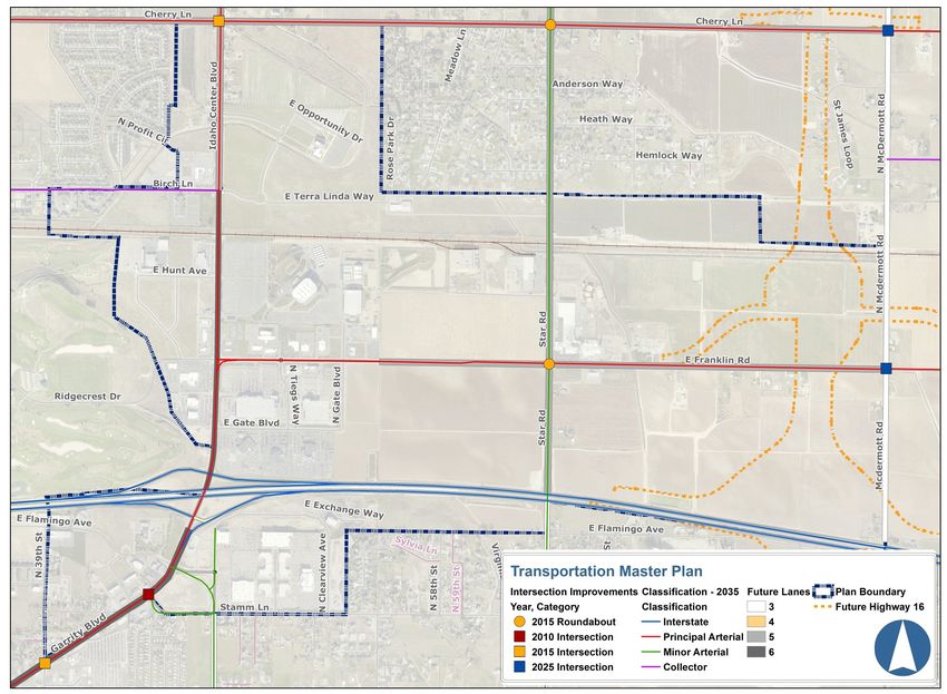
Northeast Nampa Gateway District Specific Area Plan
Public Review Draft
December 2016

Acknowledgments
                                           Northeast Nampa Gateway District
Mayor
                                            Technical Advisory Committee
Robert L. Henry
                                   Bob Bond, Eastgate Business Park
City Council
                                   Clair Bowman, City of Nampa Public Works
Paul Raymond
                                   Norm Brown, Idaho Center Commission
Darl Bruner
                                   Robin Collins, City of Nampa Economic Development
Kelly Gibbons
                                   Thayne Fisher, Auto Mall
Sandi Levi
                                   Jeff Flynn, CWI
Randy Haverfield
                                   Patricia Gordon, Rocky Mountain Management
Bruce Skaug
                                   Doug Holly, Idaho Center Commission
                                   Beth Ineck, City of Nampa Economic Development
                                   Lyndon Johns, Resident
                                   Debbie Kling, Nampa Chamber of Commerce
Planning and Zoning                Paul Maisy, Resident
Commission                         Sue Marostica, Idaho Cutting Horse Association
Lance McGrath                      Brian McClure, City of Meridian
Chad Gunstream                     Carl Miller, COMPASS
Steve Kehoe                        Mitch Minnette, CWI Foundation
Ron Van Auker, Jr                  Sonja NaPier, DDR-Gateway Development
Harold Kropp                       Patricia Nilsson, Canyon County
Bret Miller                        Scott Nunes, TMCO
Adam Hutchings                     Richard Orton, ODE LLC
Victor Rodriguez                   Richard Parcells, Resident
Peggy Sellman                      Janet Parker, Resident
                                   Grant Peterson, Auto Mall
                                   Tim Savona, Idaho Center
                                   Olga Tijerina-Menchaca, Washington Trust Bank
                                   Mark Wasdahl, Idaho Transportation Department
Planning & Zoning Staff            Wendy York, Sorrento Lactalis
Norman Holm, Director
Robert Hobbs, Assistant Director
Karla Nelson, Community Planner
Sylvia Mackrill, Administrative Operations Manager
Christopher Daly, Planner I
Shellie Lopez, Administrative Assistant

                                          Prepared By
                                          Karla Nelson, Community Planner
                                          City of Nampa, Planning Department
                                          411 Third Street South
                                          Nampa, Idaho 83651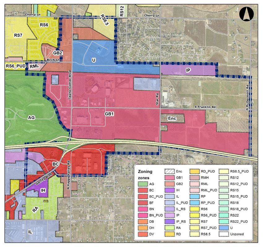
TABLE OF CONTENTS
Chapter 1 Introduction
   Executive Summary………………………………………………. 1
   Purpose and Intent……………………………………………….. 2
   Public Involvement Process…………………………………….. 4

Chapter 2 Northeast Nampa Gateway District Today
   Location and Context…………………………………………… 7
         Land Use Characteristics …………………………………7
         Current Zoning……………………………………………… 7
         Demographic Profile……………………………………… 8
         Transportation………………………………………………. 8
         Employment………………………………………………… 9
         Anchor Institutions ………………………………………… 10
   Strengths, Weaknesses, Opportunities and Threats………… 11
   Key Issues ………………………………………………………….. 15

Northeast Nampa Gateway District in the Future
Plan Area Vision

Chapter 3 Future Land Use
   Future Land Use Map Changes……………………………….. 17
   Future Land Use Designations………………………………….. 22
   Compatible Land Use Strategies………………………………. 24

Chapter 4 Movement-Connecting the District
   Future Trips…………………………………………………………. 25
   Transportation Master Plan……………………………………... 26
   Bicycle and Pedestrian Master Plan…………………………... 29
   District Connectivity……………………………………………….32
   Bus and Transit…………………………………………………….. 33
   Transportation and Connectivity Strategies…………………. 35

Chapter 5 Public Space, Design & District Identity
   Gateway to Nampa……………………………………………... 37
        Landscaping………………………………………………… 37
        Public Art…………………………………………………….. 38
        Attractive Outdoor Public Spaces……………………… 39
        Transitions……………………………………………………. 39
        Design Standards…………………………………………... 41
   Gateway Business Entertainment District…………………….. 43
   Public Space and District Identity Strategies…………………44

Action Plan

Appendix
Technical Advisory Committee Summaries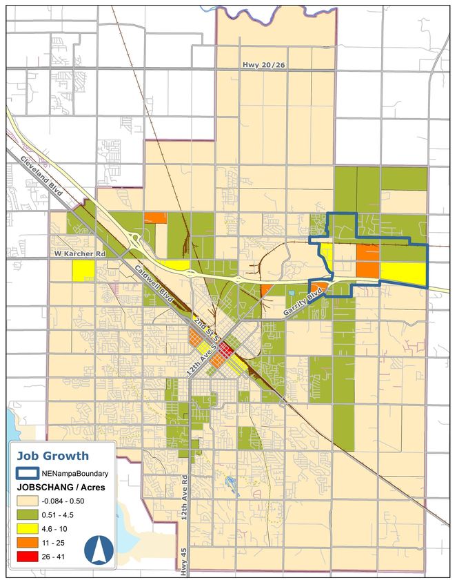
Northeast Nampa Gateway District
         Introduction
Executive Summary

Summary
The Northeast Nampa Gateway District is changing. Today, the district is in-part defined
by large tracts of undeveloped or agricultural land. By the year 2040, the district is
expected to be fully developed with employment, education, health care, shopping and
entertainment style development. Major anchor institutions serving the area are
expanding and many large land owners have aspirations to sell or develop. The Northeast
Nampa Gateway District Plan provides a vision for the district that focuses on future land
use while touching on transportation and design.

The plan proposes changes to the future land use map that capitalize on existing
incentives for companies, largely office style developments, to locate in the Northeast
Nampa Gateway District. Changes also accommodate restaurants, bars and other
entertainment-oriented businesses desired by area students, workers and patrons. These
changes shift future land uses from primarily Highway Commercial to Business Park Mixed
Use.

The Northeast Nampa Gateway District plan was informed by area stakeholders who
envision the District as:

An attractive, well planned and unique area of Nampa that draws
people throughout the valley for entertainment, education, shopping
and employment opportunities.

PAGE 1
DRAFT-Northeast Nampa Gateway District-Introduction

Purpose and Intent

Nampa has grown dramatically. In the year 2000, Nampa’s population was only 51,867,
by 2010 it was 81,557 and in 2016 the city grew to over 90,000 residents. The Community
Planning Association of Southwest Idaho (COMPASS) estimates that an additional 65,000
people will reside in Nampa’s Area of Impact by the year 2040. Some of the greatest
population growth is forecasted north of the interstate near the Northeast Nampa
Gateway District planning area. Along with an increasing population, job growth is
anticipated. COMPASS estimates that more than 30,000 new jobs will locate in Nampa’s
area of Impact by the year 2040. Some of the greatest job growth is expected in the
Northeast Nampa Planning Area.

The primary purpose of the Northeast Nampa Gateway Plan is to ensure that when growth
occurs, the form and function of that growth is generally supported by the community.
Future planning allows the community to establish expectations for how transportation,
design and land uses will be managed.

The Northeast Nampa Gateway District has an elevated importance due to its position as
the eastern entryway into Nampa. The prominent location is even more distinctive due to
the many anchor institutions that call the district home. The prominence of the location
and existing institutions warrant detailed planning aimed at enhancing the economic and
quality of life importance of this gateway into Nampa.

Reasons to Plan
   •   Identify compatible and appropriate future land uses.
   •   Align the City’s Comprehensive Plan, Future Land Use Map, and Zoning Ordinance
       with existing master plans including the College of Western Idaho Master Plan.
   •   Provide meaningful dialogue between the City and stakeholders in the Idaho
       Center area.
   •   Provide clear guidance and predictability for development.
   •   Provide a vision for the district, policy priorities and strategies to guide growth,
       investment and development.
   •   Capitalize on the Ford Idaho Center as a community asset.

Figure 1: Forecasted Population Change 2010—2040

                                                        Significant population
                                                        growth is forecasted
                                                        north of the planning
                                                        area.

                         Source: COMPASS, CIM 2040

                                                                                  PAGE 2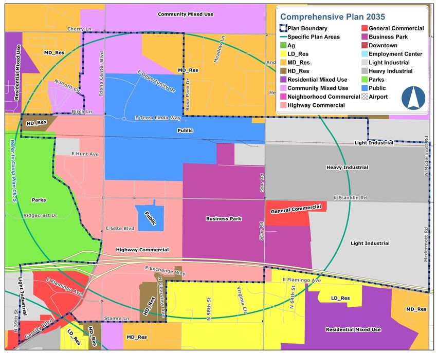
DRAFT-Northeast Nampa Gateway District-Introduction

Figure 2: Forecasted Job Change 2010—2040

Little change is expected in beige areas, green areas are expected to see moderate job
growth. More robust job growth is expected in yellow and orange areas with the greatest
growth anticipated in red areas where an additional 41 jobs per acre could occur by 2040.
Source: COMPASS, CIM 2040
PAGE 3
DRAFT-Northeast Nampa Gateway District-Introduction

Public Involvement Process

The planning process started in fall 2014 with a survey that went out to property owners
and businesses in the planning area. In total, 107 surveys were completed. A technical
advisory committee of area stakeholders was formed in the winter of 2015. The committee
met five times over the course of 2 years to shape the Northeast Nampa Gateway District
Specific Area Plan. There have also been two community open houses. Community
members have expressed a desire to see more visitor oriented services especially sit-down
restaurants and transportation system improvements.

Public Engagement Opportunities
   Initial Survey—fall 2014
   • Sent to 2,000 property owners in and around the planning area.
   • 107 completed surveys
   • Key themes—desire for more restaurants, hotels, high end bars, retail and family
        entertainment. Transportation system improvements were the most commonly cited
        issues for the area.

   Technical Advisory Committee #1—February 2015
   • Confirmed planning boundary
   • Identified strengths, weaknesses, opportunities and threats
   • Identified key issue
   • Individually described a future vision for the area

   Technical Advisory Committee #2—April 2015
   • Learned about Master Plans for CWI and the Southwest Idaho Treatment Center
   • Confirmed Vision
   • Determined a name for the planning area—Northeast Nampa
   • Used Community Viz to identify Future Land Use Designations

   Community Open House #1—September 2015
   • 54 attendees
   • Display Boards: District vision, goals and key issues, Existing future land use map,
     existing zoning, design guidelines, planned transportation improvements
   • Comments expressed a strong desire for Ridgecrest and Centennial Golf Courses to
     remain operational.

   Technical Advisory Committee #3—March 2016
   • Economic Development Strategy
   • Future Land Use Map Suggested Changes
   • Design Standards

   Technical Advisory Committee #4—April 2016
   • Transportation

                                                                                PAGE 4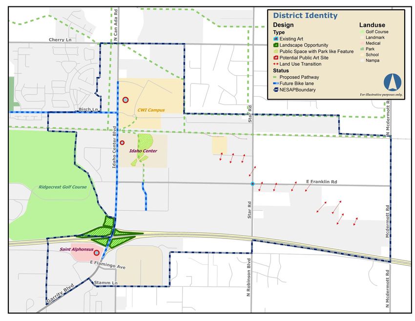
DRAFT-Northeast Nampa Gateway District-Introduction

Technical Advisory Committee #5—February 9, 2017
• Draft Plan Review
• Strategy Prioritization
• Recommendation to Planning and Zoning Commission and City Council

Community Open House #2—February 15, 2017
• 23 attendees
• Displays boards included: Current conditions, future vision, future land uses, move-
  ment-connecting the district, design and action plan strategies
• Three comment forms were submitted all dealt with transportation issues

Public Hearings
• Planning and Zoning Commission-February 28, 2017
• City Council– April 3, 2017, adopted April 17, 2017

Attendees of the September 2015 open house were
primarily concerned with the future of Centennial and
Ridgecrest Golf Courses

PAGE 5
Northeast Nampa Gateway District
Today
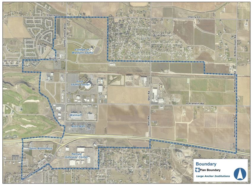
The Northeast Nampa Gateway District is the eastern gateway to Nampa along Interstate
84. The area is centrally located in the Treasure Valley. It takes 15 minutes to travel from
Downtown Boise along the interstate to the planning area and 10 minutes from Caldwell.
The district is home to the College of Western Idaho (CWI), the Ford Idaho Center, Sorrento
Lactalis, the Idaho Center Auto Mall, the Nampa Gateway Center, Saint Alphonsus
Medical Center Nampa, and Walmart, among other businesses.
Today the area includes 787 acres of undeveloped or agricultural land that is likely to face
development pressure. There are also future expansion plans for land operated by CWI
and Saint Alphonsus.
PAGE 6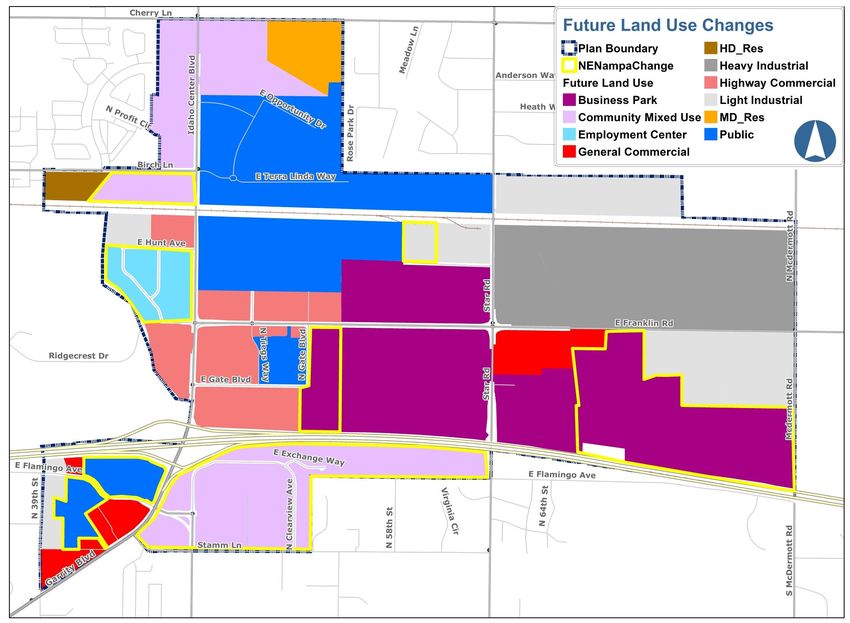
DRAFT-Northeast Nampa Gateway District-Today

Location and Context
Land Use Characteristics
The Northeast Nampa Gateway District contains 1,720 acres, or 8.4 % of Nampa’s total
acres.
   •     Agricultural land uses = 628 acres
   •     Commercial land uses = 207 acres
   •     Industrial land uses = 144 acres
   •     Public or quasi public through CWI, the Idaho Center and Saint Alphonsus = 281
         acres
   •     Office land uses = 14 acres
   •     Vacant land including undeveloped lots in existing commercial subdivisions = 159
         acres
   •     Residential including large lot residential which is likely to subdivide = 84 acres

Current Zoning
The majority of Northeast Nampa has the Gateway Business zoning designations of GB1.
The Gateway Business zoning district is intended to enhance gateways into the city of
Nampa with attractive architecture, landscaping and site planning. The GB1 district is
intended for mixed-use that is primarily commercial. The GB2 district allows for medium to
high density residential projects along with compatible commercial, office and service
land uses.

Figure 3: Current Zoning

PAGE 7
DRAFT-Northeast Nampa Gateway District-Today
Demographic Profile
The planning area is estimated to be home to 6161 people who primarily live in apartment
complexes near the College of Western Idaho. While demographics are not reported for
this exact boundary, the census block group which most closely aligns with the district has
a higher income and is younger than Nampa as a whole.
• 15.06% of the population is Hispanic or Latino (2011-2015 American Community
Survey, Census Block Group data includes some of the surrounding area)
• Median age is 27 (2011-2015 American Community Survey, Census Block Group
data includes some of the surrounding area)
• Median Household Income is $57,736 (2011-2015 American Community Survey,
Census Block Group data includes some of the surrounding area). The median
household income for Nampa as a whole is $43,461.
Transportation
Northeast Nampa is defined by I-84, Idaho Center Boulevard and McDermott Road.
Rail– Freight
The Boise Cut-off rail line runs from Boise to Nampa through the planning area. Major
commodities that are shipped include potatoes, lumber, fertilizer and fuels.
Automobile
Most who visit the Northeast Nampa Gateway area enter and exit on Garrity and
Idaho Center Boulevards. Garrity and Idaho Center Boulevards house most district
destinations and provide access to the interstate, as a result, traffic can become
congested.
• 2014 Average Daily Traffic Count for Idaho Center Boulevard south of Franklin Road
was 20,847
Bicycle and Pedestrian
Limited connectivity, congestion and the I-84 barrier make bicycle and pedestrian
travel difficult in the planning area. Recently bike lanes and sharrows were added
along Birch Lane and 11th Avenue North Extension providing a bike route to the
district. Undeveloped areas of the district largely lack sidewalks and pedestrian travel
along Idaho Center Boulevard under the Interstate is especially difficult.
Bus
The Northeast Nampa Gateway District is one of Nampa’s best served areas for bus
transit. The College of Western Idaho is a major transfer location for Valley Regional
Transit and a park and ride location. Local Nampa bus routes serve the area
approximately every two hours Monday through Friday from 7:30 a.m. to 7:30 p.m. The
CWI shuttle provides hourly service from approximately 6 a.m. to 4 p.m. while CWI is in
session. Inter-county service connects Nampa to Boise with service every 30 minutes
during peak hours.
1 2010 Census block data combined with apartment growth and average household size.
PAGE 8DRAFT-Northeast Nampa Gateway District-Today
Figure 4: Existing bike facilities and transit service
Employment:
Major employers include Saint Alphonsus, the College of Western Idaho, the Auto Mall,
Sorrento Lactalis and Walmart.
• 3,004 jobs in the planning area in 2010 (COMPASS—CIM 2040 TAZ data)
• 4,345 jobs in the planning area in 2015 (COMPASS—CIM 2040 TAZ data)
• 9.8% of jobs in Nampa’s Area of Impact are located in the Northeast Nampa
Gateway District. Saint Alphonsus, CWI, WalMart, the Auto Mall, Sorrento are the
major employers.
• It is estimated that (12,460) 18.5% of jobs in Nampa’s Area of Impact will be located
in the NE Nampa Gateway District by the year 2040 (COMPASS—CIM 2040 TAZ
data)
PAGE 9DRAFT-Northeast Nampa Gateway District-Today
Anchor Institutions
Ford Idaho Center
More than 320,000 people attend events at the Idaho
Center and horse park each year. Bringing 14.3 to 17.7
million dollars of benefit to Nampa businesses annually.
College of Western Idaho
The College of Western Idaho is one of the fastest
growing colleges in the nation. Phase 1 of CWI’s
campus expansion plan in the Northeast Nampa
Gateway District includes a health and science
building, central quad and plaza, student success
center and improvements to the circulation system.
CWI’s Canyon County Campuses currently serve 9,527
students.
Saint Alphonsus
Saint Alphonsus Medical Center Nampa is expanding
it’s facility in the Northeast Nampa Gateway District.
The new $80 million building will be five stories tall with
100 inpatient beds a six-room surgical operating suite
and a 24-room emergency department. The new
facility is expected to open in 2017.
Sorrento Lactalis
Sorrento Lactalis is part of the North American division
of the world’s largest dairy corporation. The plant in
Northeast Nampa Gateway District employees 680
people. The plant receives 5 million pounds of milk
each day and produces 200 million pounds of cheese
each year.
PAGE 10Northeast Nampa Gateway District
Strengths, Weaknesses, Opportunities & Threats
Analysis of Northeast Nampa Gateway District’s strengths, weaknesses, opportunities and
threats helped to guide future visioning. The following items were identified by the
stakeholder advisory committee and through a community survey. Opportunities form the
basis of recommendations for achieving the future vision.
Strengths
Location, Geography
• High visibility and access from the Interstate
• Central location in the Treasure valley—only 15 minutes on the interstate to Boise
• Rail line runs through the district
• The area has an agricultural/ rural feel with open spaces
Businesses, Organizations, Industry
• Diverse businesses including the Gateway Center
• Major industry and job providers in the area
• There are already working partnerships between businesses, institutions and
organizations in the boundary
• The Auto Center Mall, CWI, WalMart, Saint Alphonsus and Sorrento Lactalis are
major employers
• Saint Alphonsus is investing in the district
• The College of Western Idaho has continued student growth and investment in the
district
• The College of Western Idaho provides customized training
Idaho Center
• Idaho Center event spectators are estimated to spend 2-4 million in the local
economy annually, it was estimated that in 2006 event participants spent 6.4 million
in the local economy
• Idaho Center Horse Park attracts significant out of town visitors
• Property values have increased eight-fold in the area since the Idaho Center was
built
• Idaho Center offers space for community events and meetings
In 2016 the Snake River
Stampede drew 50,000
attendees over the 5
day event.
PAGE 11DRAFT-Strengths, Weaknesses, Opportunities, Threats
Weaknesses
• Limited labor force
• Sewer and water infrastructure availability limits growth and development
Transportation, Connectivity, Congestion
• Insufficient transportation infrastructure—limited access
• Signal timing
• Insufficient public transportation
• Lack of sidewalks or trails that connect district destinations for pedestrians
Amenities
• Lack of amenities for visitors (hotels, sit-down restaurants, visitor services, upscale
bar)
• Lack of a district identity
• Lack of park space
• Lack of corridor landscaping
Idaho Center
• Financial deficit of the Idaho Center itself
• Needed renovations at the Ford Idaho Center (merchandising space, main arena
height, parking lots, larger storage, permanent lighting, bathroom facilities,
convention/ exhibit facilities, backstage area, administration space, horse park
renovations needed to maintain a competitive edge
Transportation improvements and
congestion were by far the most
commonly identified issues in the
November 2014 district survey.
Opportunities
Development Potential
• Large tracts of developable land
• Over 200 acres of land suitable for commercial development close to the Idaho
Center
• Identified need for more full service hotels and quality restaurants
• Rail line is identified for a future high capacity transit corridor which would spur high
density development at stops. CWI/ Idaho Center has been discussed as a future
stop
PAGE 12DRAFT-Strengths, Weaknesses, Opportunities, Threats
Opportunities—continued
Economic Development Incentives
• Economic development marketing campaign for area as a destination for
entertainment, dining and shopping
• Competitive advantage for office development related to average county wage
tax incentive
• Nampa businesses capture 27% of Idaho Center visitor spending (hotels, dining,
retail, visitor services) - with increased options Nampa could capture a greater
percentage
• The new Gateway Business Entertainment district could be a catalyst for more
entertainment oriented development including restaurants
Idaho Center
• Move Canyon County fair to the Idaho Center
• Higher utilization of existing assets—more or different events at the Idaho Center
could attract more patrons who would support surrounding service businesses
Growing Institutions
• Growth at Saint Alphonsus, CWI and the Gateway Center will bring more workers
and activity to the district
• Implementation of CWI’s master plan
Design
• Higher development standards would help to create an environment that draws
people to the district
• Creation of a district theme or identify could encourage higher quality
development
• As large tracts of land develop internal connectivity for pedestrians and attractive
landscaping can be required through city code
Transitions
• Attracting a brewery could provide a good transition from industrial land to
commercial land uses
Collaboration
• Work with area stakeholders to come up with creative solution for issues that face
the district
PAGE 13DRAFT-Strengths, Weaknesses, Opportunities, Threats
Threats
• Traffic congestion
• Overdevelopment
• Incompatible land uses— Operations including noise and use of hazardous material
prevents residential development near Sorrento Lactalis
• Disrepair and appearance of private property
• Taxes that are too high
• Unaffordable housing—especially for students and young families
• More housing needed in district to create a lively district with activities day and
night—yet industrial land uses limit housing
• Development competition in other jurisdictions—local and regional
PAGE 14Northeast Nampa Gateway District’s
Key Issues
The Northeast Nampa Gateway District Advisory Committee identified three key issue
areas out of the Strengths, Weaknesses, Opportunities and Threats.
Compatible Land Use
Housing and residential land use is not compatible with existing industrial land
use
Housing, particularly dense housing is necessary to support active mixed use
development.
There is a need for well thought-out transitions from Industrial on the eastern
edge of the planning area to mixed use with some residential on the
northwest and southwest boundary.
Prioritize land uses that support existing anchors institutions and utilize Canyon
County’s competitive advantage of above average county wage tax
incentives
Traffic/ Transportation
Signal timing improvements
Congestion is getting worse and will not improve as the area develops
Need for increased access/ connectivity throughout the district
Sidewalks and bike facilities should connect district amenities
Public transportation improvements with greater frequency would help to
ease congestion
District Identity/ Amenities
Need to create a sense of place with a unique identity
The district should attract visitors and serve Nampa residents
The district should be an attractive gateway to the city with special concern
for landscaping
District theme could encourage public art
Need for more sit-down restaurants, upscale bars and venues for district
workers, Idaho Center patrons and area residents to meet socially
PAGE 15Northeast Nampa Gateway District
In the Future
Vision for the future
The first Technical Advisory Committee concluded with members writing down their
individual vision for the area in the next 20 years. Common themes include multi-use,
attractive developments that are unique and draw people to the area. Multi-modal
transportation options and transportation improvements were frequently described. The
committee agreed on the following vision statement for the Northeast Nampa Gateway
District:
Vision
An attractive, well planned and unique area of Nampa that
draws people throughout the valley for entertainment,
education, shopping and employment opportunities.
The Idaho Center , College of Western Idaho, industry, offices, and shopping already draw
people throughout the valley to the Northeast Nampa Gateway District. The vision of this
plan is to build on that success.
PAGE 16Northeast Nampa Gateway District
Future Land Use
During the latest comprehensive planning process—Nampa 2035 Comprehensive Plan—
several areas were identified for specific area plans. Specific planning around the Idaho
Center was included to determine the most desirable future land uses for this developing
entrance into Nampa. The 2035 comprehensive plan placed a significant emphasis on
Highway Commercial for the Idaho Center area as shown in pink in the map below.
Highway Commercial caters to major commercial development that accommodates
large volumes of traffic like big box stores, major shopping centers and drive-in restaurants.
Industrial land, Business Park and Public designations made up the majority of remaining
future land use designations for the area.
Figure 4: Nampa 2035 Comprehensive Plan—Future Land Use Designations
The Nampa 2035 Comprehensive Plan places an emphasis on Highway Commercial in
the Idaho Center area.
PAGE 17DRAFT-Future Land Use
Figure 5: Northeast Nampa Gateway District—Future Land Use Map Changes
1
4
2
3 5
6
7
The Northeast Nampa Gateway District shifts some Highway Commercial designations to
Business Park, Community Mixed-Use and Employment Center. The shift is primarily meant
to take advantage of tax incentives for companies that bring more than 50 jobs at above
county average wage. Canyon County average wage is significantly lower than
neighboring Ada County. The Idaho Center is especially attractive for office development
due to its location right along the interstate and the relatively short distance to downtown
Boise.
PAGE 18DRAFT-Future Land Use
Table 1: Northeast Nampa Gateway District—Future Land Use Changes by Acres
Future land Use 2035 Comprehensive Northeast Nampa
Plan Gateway District
Business Park 223.8 Acres 377.2 Acres
Public 257.5 Acres 292. 5 Acres
Community Mixed Use 85.1 Acres 234.0 Acres
Heavy Industrial 213.3 Acres 213.2 Acres
Light Industrial 306.5 Acres 169.7 Acres
Highway Commercial 296.6 Acres 115.5 Acres
General Commercial 80.3 Acres 54.4 Acres
Employment Center 0 34.2 Acres
Medium Density Residential 30.6 Acres 30.6 Acres
High Density Residential 38.9 Acres 11.2 Acres
Table 1 highlights significant land use shifts in blue. The Northeast Nampa Gateway District has
significantly more acreage devoted to business park and community mixed use than the 2035
Comprehensive Plan. Light Industrial and Highway Commercial have acreage decreases.
Future Land Use Map Changes
Change # 1: Community Mixed Use
Change #1 involves 3 parcels comprising almost 20 acres along Birch Lane. A church
occupies 9 acres, the remaining land is vacant. The previous designation of Highway
Commercial did not align with the existing church or future desires for the land.
Community mixed use designations are meant to include a variety of land uses including
commercial, service, office and high density residential. Nampa 2035 Comprehensive Plan
envisions community mixed use areas that provide interconnected circulation systems that
are convenient for automobiles, pedestrians, cyclists and transit. The designation is also
meant to include high quality architecture and landscaping.
Change #2: Employment Center Mixed Use
Change #2 involves 34 parcels comprising almost 34 acres along Idaho Center between
Franklin Road and Hunt Avenue at the Empire business park. Previously the area was
slated for Highway Commercial future land use. Parcels that have already developed are
small office and align more closely to the Employment Center Mixed Use designation,
Employment Centers are destination areas of the City where consolidation of employment
opportunities is available from various types of businesses. These areas may also include
some retail and service establishments primarily serving employees and users of the district.
PAGE 19DRAFT-Future Land Use
1
4
2
3 5
6 7
Employment Center Mixed Use Principles
• Street connectivity
• Sidewalk and pathways to promote
walking, bicycling, transit use
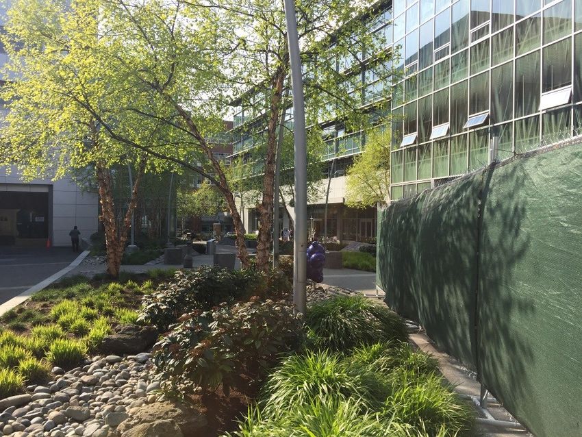
Photo by Meghan Stromberg (CC BY-NC 4.0).
Copyright 2015 American Planning Association. Photo • Mixed-use buildings can have residential
details a mixed-use building in Seattle with retail on the above ground floor retail
ground floor and office and residential on higher floors. • High design standards
Change #3: Business Park Mixed Use
Change #3 involves 3 parcels comprising 25.5 acres adjacent to the Interstate at Gate
Boulevard. Previously the land had a Highway Commercial future land use designation.
The change is meant to utilize a tax reimbursement incentive that came about in 2014 that
reimburses up to 30% of payroll, sales and income taxes for a period up to 15 years.
Companies must bring new value-added jobs with at least 50 jobs with wage levels above
the county average. The land use change is directly adjacent to a 111 acre parcel also
designated as Business Park.
Business Park Mixed Use Principles
• Compact development patterns
• Visually appealing and functional open
space
• Defined design standards
• Internal and external connectivity for
pedestrians and bicyclists
Photo by Meghan Stromberg (CC BY-NC 4.0).
Copyright 2015 American Planning Association. Photo
details a business park campus in Seattle
PAGE 20DRAFT-Future Land Use
Change #4: Light Industrial
Change #4 involves 1 parcel comprising 9
1 acres at the end of Treasure Valley Way
4 next to the horse park. Previously the area
2 had a business park future land use
designation. The current use is light
3 5 industrial as is the zoning. The light
6 7 industrial land use designation is meant to
buffer nearby heavy industrial land use
while supporting the existing land use on
the site.
Light industrial land use designations provide for processing, warehousing, manufacturing
of goods, research, development and flex space. These land uses help the City diversify its
economy. Light industrial lands buffer heavy industrial land use in the northeast corner of
the planning area.
Change #5: Business Park Mixed Use
Change #5 involves 3 parcels comprising 133 acres adjacent to the Interstate and
Mcdermott Road. Previously the land had a light industrial future land use designation.
When the land owner decided to annex the land into Nampa, Gateway Business 1 (GB1)
zoning was approved. However, a subsequent comprehensive plan map update was not
required as Nampa policy allows comprehensive plan designations to be stretched over
one parcel. Therefore, the land owner stretched the adjacent Business Park designation.
This change is formalizing that intended change to the future land use map. Business park
is also advantageous for the location in order to capitalize on tax incentives which make
Canyon County desirable for office development.
Change #6: Public
Change #6 involves 9 parcel comprising 34.8 acres belonging to Saint Alphonsus at Garrity
and the Interstate. Saint Alphonsus rezoned their campus to the new Health Care HC zone.
The Public /Quasi—Public future land use designation aligns with the healthcare campus
as it exists and with future plans. Public / Quasi-Public designations describe areas with
unique uses and functions that host community services often located within a well-
landscaped setting. The College of Western Idaho and the Idaho Center also have Public/
Quasi Public future land use designations.
PAGE 21DRAFT-Future Land Use
Change # 7: Community Mixed Use
Change #7 covers the gateway shopping center with 27 parcels comprising around 130
acres. Previously the shopping center was primarily Highway Commercial with a small
area dedicated to High Density Residential on the eastern edge. Community Mixed use is
deemed a more desirable future land use as it allows all of the existing land uses and
future desired land uses including multi-family residential but promotes higher quality
design than Highway Commercial and offers a mix of uses that could gradually transition
from commercial along Garrity to residential uses east of the shopping center.
Nampa 2035 Comprehensive Plan envisions community mixed use areas that provide
interconnected circulation systems that are convenient for automobiles, pedestrians,
cyclists and transit. The designation is also meant to include high quality architecture and
landscaping.
Bowen’s Crossing in Boise
is an example of a
Community Mixed Use
area.
Northeast Nampa Gateway District Future Land Use Map Designations
Most of the future land use designations for the district remain unchanged. Future land use
designations found in the district that were not described above, include:
Highway Commercial
Highway commercial land uses provide access
to major commercial development that
accommodate large volumes of traffic. Land
uses are more intense then other commercial.
Portions could be redeveloped over time as
Transit–Oriented Developments. Design and
development standards are encouraged.
Gas stations are an example of Highway
Commercial land use
In the Northeast Nampa Gateway District, highway
commercial land uses are primarily located near the
Garrity interchange along Idaho Center Boulevard.
PAGE 22DRAFT-Future Land Use
General Commercial
General Commercial land use designations provide the
City with a wide range of goods and services and are
generally not expected to include residential. General
Commercial areas should have an attractive interface
and convenient pedestrian connections with adjacent
areas.
In the planning area, General Commercial designations
Treasure Valley Market Place is an
exist along Garrity south of the Interstate and Franklin example of commercial land use
near Star Road.
Heavy Industrial
Heavy industrial land uses should be located away from residential development and
designed to have minimum impact to surrounding lands. Heavy industrial lands have a
potential to affect public health and safety. In the planning area heavy industrial lands are
confined to the northeast corner of the Franklin/ Star intersection.
High Density Residential
High density residential land use designations support greater than 9 residential units per
acre. Duplexes, apartments, condos, and other types of multi family are allowed. The City
expects creative designs and diverse types of housing units in all its new housing stock. The
planning area has a small high density residential designation along Birch lane. High
density residential provides an important housing option for College of Western Idaho
students along with workers employed in the district.
High Density Residential
housing in the Northeast
Nampa Gateway District.
Medium Density Residential
A small portion of the Northeast Nampa Gateway District along Cherry Lane is designated
Medium Density Residential. Housing unit density is between 4—9 units per acre. Duplexes
and low density apartments are allowed.
PAGE 23DRAFT-Future Land Use
Compatible Land Use—Strategies
GOAL: Ensure compatible land uses that supports a vibrant destination district with
entertainment, employment, education and shopping attractions.
STRATEGY 1: Adopt Northeast Nampa Gateway District Future Land Use Map
changes to the City of Nampa Comprehensive Plan Future Land Use
Map.
STRATEGY 2: Support the Economic Development office in their active recruitment of
office development for the district with Idaho’s Tax Reimbursement
Incentive.
STRATEGY 3: Maintain land use buffers around existing industrial lands. Industrial land
uses like Sorrento Lactalis provide good jobs to Nampa residents and
are threatened by encroaching residential land uses.
STRATEGY 4: Encourage changes to the Nampa Zoning Map to match Northeast
Nampa Gateway District Future Land Uses.
STRATEGY 5: Support attractive high density housing near the Nampa Gateway
Center and the College of Western Idaho to provide housing options for
students and hospital workers. Encouraging housing density in the district
will promote activity in the district throughout the day and evening and
will help support a future high-capacity transit line along the rail corridor.
STRATEGY 6: Where possible encourage housing and employment density along the
rail corridor. Density will be necessary to make a future high capacity rail
line feasible.
PAGE 24Northeast Nampa Gateway District
Movement-Connecting the District
Future Trips
As the Northeast Nampa Gateway District continues to develop, more transportation trips
through and within the district will occur and increased congestion in the area is inevitable.
Yet with careful planning, transportation concerns do not have to define the District.
Funding needed projects identified in the Transportation Master Plan and Bicycle and
Pedestrian Master Plan along with improving public transportation will all help people
reach district destinations.
By the year 2040 there are expected to be 377 acres of business park in the planning area.
The Institute of Transportation Engineers (ITE) Trip Generation Manual estimates that 149.79
trips are generated for every business park acre on a weekday. When built out, there
would be 56,470 business park trips every weekday in the planning area. The projected
business park is undeveloped today, all 56,470 trips would be new.
Table 2: Institute of Transportation Engineers (ITE) Trip Generation Estimate by Land Use Type
Land Use Weekday Weekday AM Weekday PM Saturday
Peak Peak
Light Industrial 51.8 per acre 7.96 per acre 8.77 per acre 8.73 per acre
Heavy Industrial 6.75 per acre 6.41 per acre 4.22 per acre N/A
Single-family 9.52 per unit 0.77 per unit 1.02 per unit 9.91 per unit
Housing
Apartment 6.65 per unit 0.55 per unit 0.67 per unit 6.39 per unit
Business Park * 149.79 per acre 18.86 per acre 16.84 per acre 32.61 per acre
Shopping Center 42.7 per 1,000 N/A N/A 49.97 per
sq. ft. gross leas- 1,000 sq. ft.
able area gross leasable
area
Supermarket 102.24 per 1,000 7.07 per 1,000 8.37 per 1,000 177.59 per
sq. ft. gross leas- sq. ft. gross sq. ft. gross 1,000 sq. ft.
able area leasable area leasable area gross leasable
area
Fast-food Restau- 496.12 per 1,000 53.61 per 1,000 47.30 per 1,000 722.03 per
rant with Drive- sq. ft. gross leas- sq. ft. gross sq. ft. gross 1,000 sq. ft.
thru window able area leasable area* leasable area gross leasable
area
* Business Park is the only future land use type that is completely undeveloped at the time of this plan.
Other land uses in this table are partially developed. There are 787 acres of vacant or agricultural land
in the planning area—377 acres are expected to develop as business park the remaining 410 acres
include 196 acres of commercial/ community mixed use that could fall under a variety of ITE land use
types.
PAGE 25DRAFT-Movement –Connecting the District
Transportation Master Plan
The 2035 transportation master plan recognizes that traffic congestion is a reality that
cannot be fixed with anticipated funding. Planned projects are intended to keep traffic
congestion at a level of service “D” by the year 2035. Level of Service quantifies the
operation of a roadway or intersection using six letter grades “A” being the least
congested and “F” the most congested.
The City of Nampa relies on federal, state and local funding for transportation projects.
Federal funding comes through transportation authorization bills passed by Congress.
Nampa competes with other jurisdictions across the state for federal transportation dollars
and local match is required. State funding comes from the highway distribution account
with revenues generated from fuel taxes and vehicle registration fees. There are several
sources of local transportation funding available to the city including property taxes,
impact fees, and exactions.
The Transportation Master Plan identifies more than $56 million in roadway capacity and
intersection projects for the Northeast Nampa Gateway District by the year 2035. The
Transportation Master Plan will be updated in 2017 and undoubtedly the cost estimate for
needed transportation projects in the District will grow.
Table 3: 2035 Transportation Master Plan Intersection Needs in NE Nampa
E-W Street N-S Street Project Rank Cost Timeframe
Description Estimate
(2010 $)
Garrity (2010 -
Blvd Stamm Ln Add Turn Lanes 21 $1,214,000 2019)
Add signal and (2010 -
Cherry Ln Can-Ada Rd turn Lanes 30 $2,037,000 2019)
Idaho Center Add signal and (2010 -
Birch Ln* Blvd turn Lanes 42 $1,122,000 2019)
Franklin Dual Lane (2010 -
Rd* Star Rd Roundabout 42 $1,610,000 2019)
Garrity Add signal and (2010 -
Blvd 39th Avenue N turn lanes 47 $1,903,000 2019)
Add signal and (2020 -
Franklin Rd McDermott Rd turn Lanes 26 $1,992,000 2035)
* Gray indicates completed projects
PAGE 26DRAFT-Movement –Connecting the District
Table 4: 2035 Transportation Master Plan Roadway Capacity Needs in Planning Area
Cost
Roadway Beginning Estimate
Project Location End Location Description Rank (2010) Timeframe
Widen to 5 (2010-
Franklin Rd East Gate Blvd Star Rd lanes 1 $2,881,000 2019)
McDermott Widen to 5 (2010-
Franklin Rd Star Rd Rd lanes 5 $5,762,000 2019)
Widen to 5 (2010-
Cherry Ln Can Ada Rd Star Rd lanes 19 $5,537,000 2019)
McDermott Widen to 5 (2010-
Cherry Ln Star Rd Rd lanes 23 $5,874,000 2019)
Can-Ada Widen to 5 (2020-
Rd Birch Ln Cherry Ln lanes 6 $2,769,000 2035)
Idaho Widen to 6 (2020-
Center Blvd I-84 Birch Ln lanes 9 $9,039,000 2035)
Widen to 5 (2020-
Star Rd I-84 Franklin Rd lanes 43 $2,305,000 2035)
Widen to 5 (2020-
Star Rd Franklin Rd Cherry Ln lanes 43 $5,537,000 2035)
McDermott Widen to 3 (2020-
Rd Franklin Rd Cherry Ln lanes 70 $4,290,000 2035)
McDermott Widen to 3 (2020-
Rd I-84 Franklin Rd lanes 92 $2,145,000 2035)
PAGE 27DRAFT-Movement –Connecting the District
Figure 6: Nampa 2035 Transportation Master Plan—Functional Classification
and Future Number of Lanes
Franklin Road, Cherry Lane, Idaho Center Boulevard and Garrity Boulevard are all
classified as principal arterials today and will remain principal arterials by the year 2035.
Star Road and a portion of Stamm Lane are designated as a minor arterials while Birch
lane serves as a collector street. By the year 2035 most of Franklin Road is expected to be
5 lanes, Idaho Center Boulevard will primarily have six lanes and Star Road will have 5
lanes. However, there is no current funding outside of improvements made by new
development to realize these plans.
Highway 16 is planned to eventually connect to I84 through the Northeast Nampa
Gateway District near McDermott Road. The connection is expected to cost $500 Million
and currently there is no funding source. When complete, Highway 16 will be a 21.5 mile
corridor from Emmett to Interstate 84. The “Central Valley Expressway” will have four
lanes, grade separated inter-changes and full access control to bring a high speed north-
south route to alleviate congestion on existing highways including Eagle Road.
PAGE 28DRAFT-Movement –Connecting the District
Bicycle and Pedestrian Master Plan
The City of Nampa Bicycle and Pedestrian Master Plan was adopted in 2011. The plan
was developed to advance the following goals:
• Become a truly bicycle and pedestrian friendly community
• Engage local businesses and the community
• Improve bicycle and pedestrian facilities
• Promote bicycle and pedestrian education
• Promote economic development
• Regional coordination
Projects identified for the Northeast Nampa Gateway District in the Bicycle and Pedestrian
Master Plan are listed in the following tables. Identified bicycle lane projects in the
Northeast Nampa Gateway District were estimated to cost $918,000 in 2010. Needed
sidewalk installations along existing roads were expected to cost $2.8 million.
Table 5: Bicycle and Pedestrian Master Plan—Bicycle Lanes in Planning Area
Cost
Project Street or Alignment Priority (2010)
Birch Lane between 11th Avenue North and Idaho
Bike Lanes Center Boulevard—COMPLETE High $207,503
Idaho Center Boulevard/ Can Ada Road between
Bike Lanes Franklin Road and East University Way * High $150,730
Idaho Center Boulevard/ Can Ada Road between
Bike Lanes Franklin Road and I-84 * High $118,512
Bike Lanes Garrity Boulevard from 16th Avenue North to I-84 Med $235,342
Bike Lanes N Tiegs Way from Franklin Road to E Gate Blvd Low $206,799
* Bicycle lanes along Idaho Center Boulevard are challenging as they proceed under the
interstate onto Garrity Boulevard. Width constraints at the underpass will likely force the
bike lanes to go onto the sidewalk and car movements create safety concerns for cyclists
and pedestrians. While there are challenges with bicycle facilities along Idaho Center
Boulevard and Garrity it is the only connection across the interstate in the planning area.
Farther west, bike lanes and sharrows on 11th Avenue extension do provide bicycle
facilities across the interstate.
PAGE 29DRAFT-Movement –Connecting the District
Figure 7: Example Street Cross Sections
100’ right
of way
with bike
lanes
100’ right
of way
without
bike lanes
In the future, Idaho Center Boulevard could include bike lanes providing an important connection
to land uses south of the interstate. It would also connect new high density residential near Stamm
Lane to land uses north of the interstate including CWI and the Idaho Center.
Figure 8: Bicycle and Pedestrian Master Plan
4 5
3
2
1
PAGE 30DRAFT-Movement –Connecting the District
Bicycle and pedestrian connectivity will be
greatly enhanced by proposed pathways in the 5
4
planning area.
3
Proposed District Pathways 2 1
1. Regional Rail with Trail— The most prominent
pathway planned for the district will follow
the railway corridor all the way from Boise,
through Meridian and to downtown Nampa.
Once complete, this regional pathway will
provide a safe facility for area students,
workers, and patrons to visit the area via bicycle. It will also serve as a walking path for
nearby neighborhoods, district workers and students.
2. CWI Connector Pathway— CWI campus will one day be connected to the Micron
Center for Professional Technical Education at 5725 E Franklin Road. The connecting
pathway will cross the rail corridor at Idaho Center Boulevard, the Idaho Center
Parking lot and Franklin Road.
3. Purdam Drain Pathway— The Purdam pathway will one day connect west to the
Mason Creek Pathway at Ustick and Northside and to Ten Mile Road on the east. The
pathway forms much of the northern boundary of the Northeast Nampa Gateway
District.
4. Idaho Center Boulevard Urban Connector—8ft paved sidewalk along Idaho Center
Boulevard is meant to connect north to McMillan Road.
5. Star Road Urban Connector—will be a pathway or extra wide sidewalk along Star
Road from the Purdam Pathway to the Ten Mile Creek pathway.
Table 6: Bicycle and Pedestrian Master Plan—Sidewalk Priorities in Planning Area
Location From To Priority Cost (2010)
Birch 11th Idaho Center Med High $70,645
Cherry 11th Idaho Center Med High $638,060
Franklin Idaho Center Star Med High $457,511
Idaho Center Blvd. Cherry Franklin Med High $259,983
Cherry Idaho Center Star Med Low $758,496
Garrity I84 Flamingo Med Low $100,462
Garrity Ridgecrest I84 Med Low $127,780
Star Cherry Franklin Low $378,496
PAGE 31DRAFT-Movement –Connecting the District
District Connectivity
In addition to planned pathways, future development offers opportunities to improve
connectivity and reduce congestion in the Northeast Nampa Gateway District. When
large tracts of land are developed, ensuring that streets on the quarter-section lines are
constructed could increase overall connectivity to local and regional destinations. When
development occurs, requiring developers to connect to and construct, the off-street and
on-street pathway network will help close facility gaps and increase access to those
facilities.
Gateway Business (GB) zoning covers the majority of the planning area. Gateway Business
zoning requires pedestrian pathways within the district to provide connectivity to adjacent
residential uses, schools, parks, shopping areas, public lands, transportation or other
community facilities. The planning department should continue to require internal
pedestrian and bicycle connections. Developments of one acre or more are required to
provide a pedestrian and bicycle circulation plan for the site. Strong pedestrian and
bicycle connections encourage district students and workers to walk within the district
rather than taking short car trips that congest roadways. Bicycle and pedestrian
connectivity also promotes health.
PAGE 32DRAFT-Movement –Connecting the District Bus and Transit Figure 9: Public Transportation Routes and Stops 2016 Today, the Northeast Nampa Gateway district is served by buses along Idaho Center and Garrity Boulevards with stops at 39th Street, Stamm Lane, Walmart, the Ford Idaho Center and CWI. The CWI stop offers a park and ride location with inter-county transfers to Boise and Caldwell. Connections can also be made to Downtown Nampa, South Nampa along 12th Avenue and Nampa Caldwell Boulevard. By the year 2040, public transportation coverage is expected to be similar but route frequency will increase to every 15 to 30 minutes during peak hours for primary routes. Secondary routes will have service every 30 to 60 minutes. Coverage will last 14.5 hours on weekdays and 10 hours on weekend days. An additional park and ride location could potentially be added at the Gateway shopping Center. There are plans to develop a high capacity transit corridor with service from Boise to Caldwell with a stop in the Northeast Nampa Gateway District. Most plans envision this corridor running along the existing Boise cutoff rail line. Most likely the high capacity transit stop would be near Idaho Center Boulevard between CWI and the Ford Idaho Center. Easy, quick and reliable transit along a high capacity corridor would transform the PAGE 33
DRAFT-Movement –Connecting the District

Northeast Nampa Gateway District. Students throughout the valley could easily reach the
CWI Nampa campus, district workers and businesses would benefit as would patrons of
the Idaho Center. Transit oriented development like high density housing and dense
employment would help to support a future transit corridor.

Figure 9: Public Transportation Routes 2040

                                              Future High Capacity
                                              Transit Corridor

2040 Route Frequency
• Premium Service: 10 to 30 minutes all day, dedicated right of way, limited stops
• Employer Express Service: 30 minutes peak
• Primary Service: 15 to 30 minutes peak, 30 to 60 minutes midday, frequent stops
• Secondary Service: 30 to 60 minutes all day, frequent stops

Service Span
Weekday Routes
   • (Premium, Primary, Secondary, and Express): 7 hours peak, 7.5 hours off peak
   • (Employer Express): 7 hours peak, 0 hours off peak
Weekend Routes
   • (Premium, Primary and Express Only) 7 hours peak, 3 hours off peak

                                                                               PAGE 34
DRAFT-Movement –Connecting the District
Transportation and Connectivity—Strategies
GOAL: Develop and maintain a coordinated and balanced transportation system in
the Northeast Nampa Gateway District that promotes economic development and
provides a variety of choices among transportation modes, including automobile,
public transit, bicycle and foot.
STRATEGY 1: Look to fund projects identified in the Transportation Master Plan and
Bicycle and Pedestrian Master Plan in the planning area.
STRATEGY 2: Encourage connectivity through new developments including
connecting roads at the quarter section lines and pathways or
sidewalks which allow pedestrians to easily walk to and throughout the
new development.
STRATEGY 3: Use traffic control systems, Intelligent Transportation System
technologies (such as real-time traffic information) to improve traffic
flow in the Idaho Center area.
STRATEGY 4: To ease congestion and improve traffic flow consider an access
management plan, additional collector roads and innovative
intersection design.
STRATEGY 5: Increase affordable and accessible public transportation to important
district destinations include CWI, the Idaho Center, Walmart, and major
employers.
STRATEGY 6: Minimize conflicts between different modes of transportation to
improve safety.
STRATEGY 7: Enhance and promote the use of bicycles and walking as viable forms
of transportation by providing safe public facilities, including multi-use
pathways, bicycle routes, bicycle lanes and sidewalks.
STRATEGY 8: Require transportation infrastructure improvements including
pedestrian connectivity with all new development.
STRATEGY 9: To ease congestion, promote alternative transportation options
through education campaigns on riding transit, bicycling or car-sharing
programs. Support organizations and area businesses to develop
programs that help employees use alternative modes of
transportation.
STRATEGY 10: Continue parking/ park-and-ride management plans as a means to
help improve the viability and effectiveness of public transit services in
the city. Revisit parking requirements for more effective/efficient use
and plan for special events by providing park and ride options.
PAGE 35You can also read