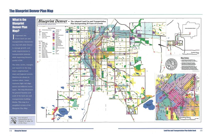
PLAN GUIDE - City and County of Denver
←
→
Page content transcription
If your browser does not render page correctly, please read the page content below
PLAN GUIDE
Chapter 1: An Integrated Land Use and Transportation Plan

C    reating a vibrant, beautiful,
     community-oriented city —
where people feel comfortable
                                     world-class city. And like any
                                     growing world-class city, Denver
                                     must remain true to its essence
                                                                             Blueprint Denver encourages
                                                                             and promotes more efficient
                                                                             use of transportation systems,
walking to neighborhood shops,       and character yet be enriched           a variety of transportation
new buildings are constructed        by new thoughts, actions and            choices, appropriate and mixed
thoughtfully, old buildings are      energy as it moves toward its           land uses, and the ongoing
renovated lovingly, and streets      place in history as a community         reinvestment in our neighbor-
provide multi-modal access           of unparalleled vision.                 hoods and business districts —
to major neighborhood and                                                    all of which ultimately will
business hubs — does not occur                                               improve our quality of life.
by accident. It requires the                 Denver citizens
                                                                             Only then will our city truly
collective vision and wisdom of             are the architects               resonate with the richness
the people who live here and               of Denver’s future.               and depth brought to bear
who want the best for future
                                                                             by a community of innovative
generations.
                                                                             thinkers and doers.
Those of us who live in Denver       That vision and action for
appreciate the richness of all       Denver are known collectively
our city has to offer: the quiet     as “Blueprint Denver.” Developed
neighborhoods threaded together      over 20 months, it is a plan
by a strong sense of community       that aims to improve our city by
spirit, combined with the pride      shaping the places where we will
and the economic stamina of a        live, travel, work, shop and play.

                                                               Land Use and Transportation Plan Guide Book    1
Shaping our City for a Better Tomorrow

                       T   he quality of life in any city,
                           including Denver, depends
                       in large part on travel — how
                                                             ment and commercial buildings
                                                             along its route.

                                                             Blueprint Denver looks at the
                       easy it is to get from home to
                                                             important relationship between
                       work and back, the amount
                                                             land use and transportation
                       of time spent commuting, and
                                                             and advocates that land use and
                       the types and degree of choices
                                                             transportation decisions be made
                       available for getting around.
                                                             in conjunction with each other.
                       Closely related to that are the
                                                             These decisions can and should
                       choices we make about how land
                                                             be carried forward through
                       should be used. The types and
                                                             governmental regulations,
                       appearances of buildings, how
                                                             new public infrastructure,
                       they function in a neighborhood
                                                             and innovative partnerships
                       or business district, and where
                                                             with individuals, businesses,
                       they are located all have an
                                                             local governments, and other
                       effect on transportation use. For
                                                             organizations.
                       example, a small neighborhood
                       that combines a shopping
                       area with nearby residences               “Cities are an invention
                       (known as a “main street”                  to maximize exchange
                       area) encourages people to walk,
                                                                     (goods, cultures,
                       whereas a strip mall tends to
                                                                      friendship and
                       require auto travel. By the same
                       token, decisions made about
                                                                    knowledge) and to
                       transportation also affect what               minimize travel.”
                       we build and where we build it.              —David Engwicht,
                       Freeway interchanges encourage             Reclaiming our Towns
                       people to drive to stores and                    and Villages
                       services, while light rail often
                       encourages main street develop-

                         Land Use and Transportation Planning
                         In the 1920’s (top), many pedestrians and bicyclists used Denver’s
                         16th Street, and automobiles shared the street with streetcars.
                         In the 1950’s, the street was modified for use primarily as a one-
                         way route to maximize auto movement; transit use and foot-traffic
                         decreased as the street became a hostile place to walk. Today
                         (bottom), 16th Street actually moves more people than it did in
                         1950, but because of the people-friendly design, it is also one of
                         the premier urban destinations in the region. Sixteenth Street
                         illustrates many of the key concepts of Blueprint Denver - that
                         a right-of-way can move more people and be a more pleasant place
                         to be when its design jointly considers land use and transportation.

2   Blueprint Denver
Blueprint Denver and the Denver Comprehensive Plan

                                                                                 Plan 2000
                                                                                 Plan 2000 is a document
                                                                                 drafted through an extensive,
                                                                                 two-year process involving
                                                                                 citizens, elected officials
                                                                                 and stakeholder groups. It
                                                                                 sketches a vision for Denver
                                                                                 through the development
                                                                                 of goals, visions of success,
                                                                                 objectives and strategies.

M      ost metropolitan cities         The Denver Comprehensive Plan 2000
                                       calls for balanced and coordinated
       have a variety of land-use                                                The Land Use chapter of
                                       land use and transportation to
plans that are related to one          facilitate the city’s vision for the      Plan 2000 lists its first two
another, with each serving a           future. The city has not prepared         objectives as:
specific purpose. Denver is            a new citywide land use plan
                                       since 1956.                               1. Denver should undertake
no exception and has built
                                                                                 a land-use and transportation
Blueprint Denver upon a strong
                                       comprehensive approach to                 plan to “balance and
foundation of complementary
                                       address all the components                coordinate Denver’s mix
plans that guide how and where
                                       needed to achieve a livable,              of land uses to sustain
the city grows.
                                       successful city.                          a healthy economy, support
The Denver Comprehensive Plan                                                    the use of alternative
2000 (Plan 2000) creates a vision      Blueprint Denver is a supplement          transportation, and to
of what Denver residents want          to the Comprehensive Plan. It             enhance the quality of life
for their community through a          is also consistent with the Core          in the city”; and,
series of goals, visions of success,   Elements of Metro Vision 2020,
                                       the Denver Regional Plan, by              2. The city should “clarify
objectives and strategies. Blue-
                                       nurturing a “Balanced,                    and update Denver’s zoning
print Denver serves as the first
                                       Multi-modal Transportation                ordinance and related
step in implementing the vision
                                       System,” developing “Urban                ordinances, regulations and
outlined in Plan 2000.
                                       Centers”                                  procedures to be consistent
Blueprint Denver outlines the          and maintaining “Environmental            with the goals and objectives
specific steps that must be taken      Quality” by promoting walking             of Denver’s Citywide Land
to achieve this vision. The vision     and transit use. Denver                   Use and Transportation
calls for substantial changes in       adopted Metro Vision 2020                 Plan.”
how the city plans for the future.     as a supplement to Denver’s
These changes ensure continued         Comprehensive Plan 2000.
progress toward a sustainable
future and enhanced quality
of life in Denver. Many good
examples of successful planning
are evident in Denver, but they
often are isolated victories within
a particular neighborhood or
district. This plan develops a

                                                                Land Use and Transportation Plan Guide Book      3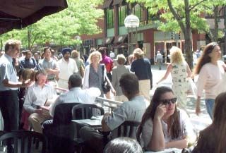
Chapter 2: Denver Today and Tomorrow

                                     T   he City and County of
                                         Denver is growing at its
                                     fastest rate since the 1940’s.
                                                                          together. Streets that fail to be
                                                                          pleasant and safe places to walk
                                                                          discourage people from walking
                                     Between 1990 and 2000, the           to transit stops and thus dis-
                                     city’s population increased by       courage transit use.
                                     more than 87,000 residents,
                                                                          Growth and expansion is ex-
                                     an increase of nearly 19 percent.
                                                                          pected in the next 20 years. By
                                     For many people, Denver is
                                                                          changing policies about how we
                                     a desirable place to live with
                                                                          develop land and build our
                                     an increasing array of urban
                                                                          streets, we can use growth to
                                     amenities. Current trends,
                                                                          make positive changes in the
                                     however, suggest that congested
                                                                          city, instead of letting unwanted
                                     roads and air pollution may
                                                                          present growth patterns compro-
                                     threaten the area’s future
                                                                          mise our future.
                                     prosperity and livability.

                                                                            Our Future Based
                                     Residents in the Denver region
                                     drove an average of 22 miles a
                                     day in 1999 — up from 18 miles         on our Past
                                     in 1990. That translates to a 20
                                     percent increase in fewer than         Denver Today and Tomorrow

                                     10 years. The result is that 37        describes the past, present

                                     percent of daily travel time is        and the future based on

                                     spent in congestion — up from          our present zoning, most

                                     22 percent in 1990.                    of which dates back to the
                                                                            1950s. Our present zoning
Growth in the Denver Region, shown
                                     Traffic congestion, travel dis-        allows growth to occur to a
in 1960 (top), 1990 (middle) and     tance and travel miles are             certain intensity. Looking at
forecast for 2020 (bottom).          increasing and likely to continue      where zoning allows growth
                                     in that direction. Only about          and where it is likely to
                                     10 percent of the daily trips in       happen based on market
                                     the City and County of Denver          conditions tells us what the
      Without a change in
                                     occurred on public transit in          alternative is to Blueprint
      existing policies, the
                                     2001. Without a change in              Denver.
    disconnect between land          public policy and an extensive
     use and transportation          expansion of the transit system,
          will continue.             public transit use is expected to
                                     increase by just one percent for
                                     work-related trips in the next
                                     twenty years.

                                     Without a change in existing
                                     policies, the disconnect between
                                     land use and transportation will
                                     continue. Due to incompatible
                                     design, adjacent commercial and
                                     residential developments don’t fit

4     Blueprint Denver
What is the Current Alternative to the Blueprint?
Key Concepts
• Denver’s population in
Lakewood 2000 was 554,636 people -
a growth of 87,000 people
from 1990 to 2000
• By 2020, Denver’s popula-
tion is forecasted to
increase by 132,000 people
or 60,700 households
• Employment is expected to
Denver
increase by 109,200 jobs
by 2020
• Traffic congestion will
increase, with a projected
162 miles of roads operat-
Above: 132,000 people, the forecast population increase for Denver in the next 20 ing near or over capacity
years, equals roughly the population of Lakewood in 2000 (144,000)
• The capacity and permitted
Z oning is the city’s official
land use policy. The zoning
scenario reveals a haphazard
downtown. It also predicts a
large amount of new housing
scattered among existing neigh-
locations for growth based
on current zoning will
not make it possible to
and unfocused potential land use borhoods, more costly maximize the benefits
pattern that does not correlate infill housing, higher traffic from growth or to avoid its
with major transportation flows in neighborhoods and negative impacts
corridors, transit station areas only a nominal increase in
• A blueprint for how Denver
or the neighborhoods near transit ridership.
should grow is vital to
Denver’s future
Denver Population Change For detailed
information go to
chapter 2, page 8 of
100000 the Plan.
80000
60000
40000
20000
0
-20000
-40000
1880 1890 1900 1910 1920 1930 1940 1950 1960 1970 1980 1990 2000
Land Use and Transportation Plan Guide Book 5Chapter 3: Blueprint Denver Concept
Left top: Providing a variety of
interconnected transit options is key to
a successful transit system.
Right top: Areas of Stability often
include well established residential
T
neighborhoods. hrough an intensive public is most important, and Areas
Below: A well designed pedestrian input process, the city’s of Change, where investment in
and bicycle friendly district, such as Land Use and Transportation new buildings and alternative
this one in Chicago, can become a
Advisory Committee, planning transportation can be integrated.
regional draw.
staff and consultants developed The idea is that some growth
Blueprint Denver, which will that would otherwise occur in
guide the city’s growth during Areas of Stability is redirected to
the next 20 years. Areas of Change. New develop-
ment is thereby directed to areas
Blueprint Denver calls for
where increased density and
dividing the city into two broad
mixed-use development is
planning categories: Areas of
appropriate, generally along
Stability, where maintaining and
major corridors, near planned
enhancing the existing character
transit stations, and the down-
town area. The planning process
showed that the public felt
Blueprint Denver
strongly about wanting to
organizes the city into maintain stable neighborhoods -
Areas of Stability and a goal compatible with promoting
Areas of Change. sustainable growth and develop-
ment during the next 20 years.
6 Blueprint DenverHow Blueprint Denver was Developed
Left: Denver’s parks and open space
are a unique part of its urban
environment that should be preserved
and enhanced.
Key Concepts
• Plan 2000 directed the
City to undertake a land
use and transportation
plan - Blueprint Denver is
a supplement to Plan 2000
• Reinvestment and charac-
ter preservation will
The Blueprint Denver Backdrop promote stable neighbor-
hoods
T he Blueprint Denver and the
zoning scenarios used the
same housing and employment
pedestrian-friendly and bike-
friendly environment, increased
transit service on the major
• Growth will be directed to
Areas of Change
growth. The growth was corridors, shared parking in • Mixed-use development
redistributed to reduce develop- many of the business districts, will bring employment,
ment in Denver’s existing and more housing in mixed-use shops, services, and
residential neighborhoods (Areas areas. entertainment close to
of Stability), and increase it residential areas and
along major corridors, in close-in encourage access by
neighborhoods, and around walking, biking and transit
existing and planned light-rail
• Multi-modal streets will
stations (Areas of Change). In
increase the capacity of
addition, the Blueprint scenario
the transportation system
promotes many urban design
to move people and will
goals, resulting in a more
result in more active
corridors that are attrac-
Two important
tive to a variety of land
components of the
Blueprint Denver uses, not just auto-
scenario: increased oriented uses
transit service in
major corridors • Interconnected and
(Right Top) and infill diverse transportation
development in
options will improve the
Areas of Change
(Right Bottom). convenience and accessi-
bility of rapid transit
• Mountain views, parks,
parkways and other
legacies will be preserved
Land Use and Transportation Plan Guide Book 7Concept: Mixed-Use
Above: Mixed-use development blends
residential with commercial uses such
as offices; Below: Walking has been
T he term “mixed-use” refers
to a street, building or
district that combines several
Mixed-use is not a new concept;
downtowns and older neighbor-
hoods are excellent examples of
shown to be more prevalent in mixed-
use developments such as this area in compatible land use types. A functional mixed-use districts.
LoDo; the chart below shows how commercial development with Only in recent decades did
higher densities promote walking. several small shops on the development begin to segregate
ground floor, for example, its uses, as the car became the
may include some apartments, primary mode of transportation.
lofts, or offices above. Another
Today, communities are looking
example is a block of new
for ways to reduce reliance on
buildings that contain town
the car and increase opportuni-
houses and a small grocery store
ties for walking. An apartment
or pharmacy.
or office building with retail
The benefit of mixed-use devel- shops on the ground floor is a
opment is that it enables people traditional mixed-use building
to shop, live and work in the that is popping up again in new
same area. People who live in communities.
mixed-use areas tend to travel
shorter distances and frequently
choose alternatives to driving for
their daily trips.
8 Blueprint DenverConcept: Multi-Modal Streets
A multi-modal (or multi-
purpose) street is one that
balances the needs of all types
or modes of travel, so that
people have choices in how they
get from one place to another.
Most of our city is already built
up – widening roads therefore
would be extremely expensive
and disruptive. In addition to
the higher speeds and traffic
volumes, wider roads detract History
from pedestrian safety and
Throughout most of history,
convenience - diminishing the
streets were used for a
quality of life in adjacent
variety of travel means, such
as walking, carriages, and
Mixed-use development trolleys. When the car
became the predominant
and multi-modal streets
mode of travel after World
are two fundamental
War II, street design increas-
concepts in Blueprint ingly emphasized the move-
Denver. ment of traffic at relatively
high speeds, requiring larger
neighborhoods. However, streets and intersections,
Denver will need to make often making the street a
targeted capacity improvements hostile place for pedestrians,
to roadways and other public bicyclists, and people waiting
infrastructure. for transit. The concept
of multipurpose streets
Blueprint Denver sees streets
Above: The capacity of a street to
in today’s city represents
as a place to move people, not
move people can be very different returning street design to
depending on the form of travel. just cars. Streets would serve
its historical function.
Pedestrians, bicyclists and buses as a mechanism to move people
occupy much less room than through a variety of means,
automobiles. Right: Multi-purpose
including by bus, bike, car, For detailed
streets return street design to its
and foot. Simultaneously, these information go to
historical function, depicted here.
chapter 3, page 25
streets increase the curb appeal of the Plan.
of a place that offers convenient
access to transit, businesses
and housing.
Land Use and Transportation Plan Guide Book 9Chapter 4: Land Use Building Blocks
Key Concepts Building Blocks Land-Use Types
• The Blueprint Denver Plan District Downtown, Employment, Industrial, Campus,
Map sets the basic param- Parks and Open Space
eters for future land-use Residential Areas Mixed-Use Neighborhood, Single-Family
decisions Residential, Single-Family/Duplex Residen-
• Land use and transporta- tial, Urban Residential
tion types are multi- Corridor Pedestrian Shopping, Commercial
dimensional and intercon-
nected Centers Neighborhood, Town, Regional, Transit-
Oriented Development
• Descriptions of the build-
ing blocks, land-use and
street types indicate the
future composition and
Districts
urban design of different Parks and
areas in Denver
Open
• The design of multi-modal Space
streets helps balance auto
Parks and
needs with the needs of
Open Spaces
other forms of travel
play a key role in the city’s
• Design and development quality of life. These places
standards will assure that provide breathing space in urban
tions to parks. Parks and open
new development is areas. Parks and open spaces
space also include natural areas
compatible with its sur- include manicured parks, sports
where wildlife habitat preserva-
roundings and enable the fields, trails, greenways, park-
tion is promoted.
pleasant and safe integra- ways and “green street” connec-
tion of streets within a
community setting
Residential Areas
Single- Urban
Family Residential
Residential Urban residen-
Single-family tial neighbor-
homes are hoods are high
the predominant residential density and primarily residential,
type, and represent the majority with some small scale commer-
of Denver’s residential areas. cial uses. A variety of housing
Many post-war single-family types are present — townhouses,
residential areas were designed small apartment buildings, and
exclusively for auto transporta- sometimes high-rise residential
tion and lack sidewalks. structures. New housing tends to
be in mid to high-rise structures.
10 Blueprint DenverCenters
Neighborhood Center Regional and Town Transit Oriented
These centers Centers Development (TOD)
are small These are TOD’s are
areas which similar to unique
serve every- neighborhood communities
day shopping, centers but near transit
service or meet a larger stations that
entertainment needs of one or variety of combine
several neighborhoods. A neigh- shopping, entertainment, service several land uses such as single-
borhood center may also contain and employment needs and are family homes, townhomes, multi-
offices that employ nearby large enough to serve several family buildings, live-work units,
residents. Occasionally, boutique neighborhoods. Specialty shops, commercial buildings and retail
shopping or popular restaurants entertainment and other types of uses. These centers create a
act as a regional draw. Good unique services attract people to transit-supportive environment
pedestrian and bus transporta- town and regional centers from by encouraging a mix of land uses
tion links are central characteris- across the city. that allow people to live, work and
tics of neighborhood centers. play in a community without
necessarily relying on a car.
Corridors
Pedestrian Shopping Corridor:
A pedestrian shopping corridor
exhibits the same land uses as a
town or neighborhood center, but
it orients those uses in a linear
pattern. These corridors are
designed to be compatible with
surrounding residential neighborhoods. Pedestrian
amenities, such as a continuous street frontage of
building and wide sidewalks; good transit services;
and on-street parking and shared parking are all
common characteristics of pedestrian shopping
corridors.
Land Use and Transportation Plan Guide Book 11Transportation Building Blocks
T raditionally, the types of streets found within
every city have been categorized primarily by
how many cars use them at any given time. But
the area where vehicles move, the area where
pedestrians move, and the areas where buildings
interface with the rest of the street. Street types
Blueprint Denver changes that and instead defines ensure that the design of the entire right of way –
streets by how they function for cars, how they travel lanes, parking, bike lanes, medians, side-
function for other types of transportation such as walks, and street trees – are appropriate to and
walking, mass transit and bicycling, and how the complement the adjacent buildings. Street types
adjacent buildings are designed and used. and land use types become the primary components
of integrated land-use and transportation decisions.
Streets are not considered by themselves, but are
Multi-modal streets are classified as Residential,
defined in part by the buildings and land uses that
Main Streets, Mixed-use, Industrial, and Commer-
are located next to them. Streets are comprised of
cial Corridor. Three of these are illustrated here:
Multi-Modal Street Types
Residential streets Main streets Commercial streets
Residential Main streets Commercial
streets are serve the streets
mainly highest balance a
designed to intensity retail variety of
emphasize and mixed travel choices
walking land uses in such as
and bicycling, although larger areas such as the downtown pedestrian, bicycle and transit
residential streets provide and in regional and neighbor- use together with auto traffic.
additional transportation hood centers. Like commercial Since they are frequently located
choices. These streets tend to streets, main streets are de- on arterials that serve as the
be more pedestrian-oriented signed to promote walking, backbone of Denver’s commerce,
than commercial streets, giving bicycling, and transit within an having vehicles is a priority.
a higher priority to landscaped attractive landscaped corridor. However, the street design needs
medians, street trees, sidewalks, To further create a pedestrian- of each mode of travel - such as
on-street parking, and bicycle friendly atmosphere, main streets sidewalk width, on-street park-
lanes. have wide sidewalks, street ing, or number of lanes - should
furniture, outdoor cafes, plazas, be balanced based on the
and other public spaces. On street availability of transit, character
parking usually is provided to and intensity of adjacent land
serve adjacent land uses. uses, and the functional role of
each commercial street.
12 Blueprint DenverP edestrian, bicycle and transit systems are all
important to provide an attractive alternative to
auto travel for all lengths of trips. All trips start
and end with walking. If the pedestrian system of
our streets and neighborhoods provides safe and
pleasant walking routes, residents may make more
trips on foot. Bicycling serves a similar role but
can accommodate longer trips. If the transit
system is well integrated with walking and bicy-
cling, long trips such as commutes to work can be
accomplished entirely without private automobile use.
Transportation Systems
Rapid transit system Pedestrian system Bicycle system
The rapid transit system is Since every trip begins and ends Bicycles are a viable alternative
important because it provides with walking, the pedestrian to driving, and an effective
infrastructure that can shape system is the primary transpor- bicycle system should be well-
a land use pattern of transit- tation element that connects maintained, continuous and
focused development. This all travel modes. The pedestrian secure. Adequate connectivity
leads to a reduction in automo- system is needed to move involves a continuous and
bile trips and the resulting people and provide them interconnected system of bicycle
pollution and congestion. access to adjacent land uses. lanes, bicycle routes and off-
The rail transit element of the A safe, comfortable and attrac- street paths. Intersection design
planned regional rapid transit tive environment includes a should accommodate bicycles.
system consists of both light continuous system of trails and Secure bike parking should be
rail and commuter rail service. sidewalks, wider sidewalks at near building entrances and
congested locations, visible transit stops.
crosswalks, pedestrian signals,
landscape buffers between
sidewalks and streets and a
variety of public open spaces.
Land Use and Transportation Plan Guide Book 13Chapter 5: Land Use Concepts
L and-use policies address a
range of factors related to
building design, type, location,
The present Denver
Walkable districts, both commercial
and residential, are a product of
objective regulatory standards and
zoning code has a should be encouraged in redevelop-
and distribution throughout the ment as well as new development
city. For much of the 20th
number of outdated areas.
century, urban land use policies, restrictions on land uses.
Good design is critical as new
particularly zoning, focused
buildings are constructed.
on separating uses that were
Quality urban design can retain
incompatible. Keeping noisy, the teaching of “the card game
and improve a neighborhood’s
belching factories separate from known as bridge,” implying that
character and quality of life.
single-family houses is the most one can’t teach canasta in that
Commercial buildings that are
dramatic example. Denver’s zone.
built close to the sidewalk, have
current zoning code, adopted
Implementing Blueprint Denver interesting facades with store-
in 1956, has this emphasis on
will require revising the current front windows, and attractive
carefully defining and regulating
zoning code to streamline the way landscaping can mean the
uses.
regulations are administered, to difference between a friendly,
Currently, Denver places a great cull outdated regulations, and to pedestrian-oriented neighbor-
deal of emphasis on regulating better address key issues such as hood and an auto-oriented
the activities that occur within design. Restrictions on develop- strip mall. For residential
buildings. While it is important ment such as size, bulk, number areas, design standards related
to regulate use, the current of units, and adequate to building proportions and
Denver zoning code has a landscaping buffers - along with orientation can improve the fit
number of antiquated and often basic design standards - are more of buildings in older neighbor-
outlandish, restrictions on land effective components of an hoods.
uses. One example is a land- updated zoning code.
use definition that permits
16 Blueprint DenverAbove top: The Denver Zoning Code,
Key Concepts adopted in 1956, is outdated, overly
complex and difficult to administer.
• Land-use regulations are the primary tool to designate areas for
Top right: Infill development should
the appropriate type of development
be compatible with adjacent build-
ings. These townhomes were built to
• Appropriate land-use regulations ensure that buildings work
match historic homes in the area.
together with public infrastructure to create desired develop-
Bottom right: Development standards
ment patterns
such as Floor Area Ratio (FAR) and
• The Blueprint Denver vision cannot be implemented effectively maximum height limitations would
help to control incompatible scale and
with the City's current unwieldy zoning code building form. Design standards that
control roof form and building
• New zoning should concentrate as much on the design of a
placement would also help prevent
building as it does on regulating the activities that occur within this type of incompatible architecture.
buildings
Land Use and Transportation Plan Guide Book 17Chapter 6: Transportation Concepts
Left: Providing seamless connections
within one or between several modes
of travel is an essential part of a
successful transit system.
Below: Designing a transportation
system with adequate pedestrian
amenities and connectivity is essen-
tial since all trips begin and end in
walking.
B lueprint Denver provides
strategies and policies
to expand the choice of viable
Denver’s transportation
Denver’s transportation system
consists of multiple components
that must work together to make
system is composed of
transportation modes available Blueprint Denver a reality. These
multiple components that
to people including walking, components include the transit
biking, and taking transit. must work together to system, pedestrian facilities,
The car will be one of several make Blueprint Denver a bicycle facilities, parking, the
viable modes of transportation. reality. system-wide tools of travel
demand management and
For that to occur, walking,
transportation systems manage-
bicycling and transit must be
ment, and roadway network and
as attractive and convenient
drainage infrastructure.
as driving a car - meaning the
existing transportation infra-
structure must be enhanced for
all types of travel. Connecting
modes of travel is more than
simply ensuring there is a
continuous sidewalk or bike
lane; it requires forethought
to integrate transportation
facilities so that they work
together cohesively. It also
requires attention to specific
elements that make walking,
biking and waiting for transit
on streets a safe, pleasant,
and convenient experience.
18 Blueprint DenverAbove: Transit-Oriented Develop-
ments (TOD) are designed around a
central transit stop that can be
reached on foot from the surrounding
district. Left: Transit stations that are
both functional and attractive can
become a focal point for neighbor-
hoods.
Transportation policies primarily
address the public infrastructure Key Concepts
of streets, alleys, bikeways, • The entire right-of-way -- including travel lanes, on-street
sidewalks and transit services. In parking and sidewalks - should be appropriate to and comple-
addition, the transportation ment adjacent land uses, including buildings and public open
policies recommend tools and space
strategies that affect how private
• Since every trip begins and ends with walking, the pedestrian
development contributes to the
environment is the primary transportation element that con-
transportation system. Private
nects all travel modes
development contributes physical
improvements (e.g., providing car • The rapid transit system shapes land use patterns by promoting
access across city rights-of-way more sustainable development focused around transit stations
or building new streets as part
• Connectivity means a seamless connection for each mode of
of a new development).
travel (walking, biking, driving and transit use), as well as
Indirectly, city policies can affect
between modes of travel
development by using tools that
reduce travel demand and • Many tools are needed to address Denver's transportation issues
encourage alternatives to the including: better transit, better bike and pedestrian connections
car. Most of the tools other than and neighborhood traffic management measures to reduce
transit require implementation speeds on residential streets
from the city since the design,
operation, maintenance and
approval of transportation
facilities are public agency
responsibilities.
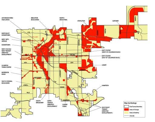
Land Use and Transportation Plan Guide Book 19Chapter 7: Areas of Change and Areas of Stability
P reservation and revitalization
of neighborhoods was a
prevailing concern throughout
the planning process. The need
to direct and manage the
location, type and intensity of
future development to bring
about wanted change was
balanced by an equal desire to
maintain those areas of the city
with an established character.
These divergent perspectives led
to the plan concept of Areas of
Stability and Areas of Change.
Areas of Stability and Areas of
Change have a symbiotic rela-
tionship and are not mutually
exclusive. Each area in the city
occupies a place on a continuum
from change to stability, and its
location on the continuum may
change over time.
Areas of Stability include the
vast majority of Denver and are
primarily the fairly stable
residential neighborhoods where
minimal change is expected
during the next 20 years. The
goal is to maintain the character
of these areas yet accommodate
some new development and
E. Colfax on the continuum of change: Top: E. Colfax in 2000 is an Area of
redevelopment to prevent Change. If public infrastructure investments to improve the street design,
stagnation. Some Areas of regulatory changes to stimulate private, mixed-use development and partnerships
Stability mainly need public to fund and maintain the desired changes are successfully undertaken, E. Colfax
becomes an Area of Stability, bottom.
infrastructure, additional
services or investment in housing These places are Areas of A combination of regulatory,
to maintain and improve quality Change. In these areas Blue- partnership and public infra-
of life. Others need development print Denver promotes reuse, structure will be employed in
and design standards to redevelopment and greater Areas of Stability and Change
maintain their character. Mean- sustainability by bringing to achieve desired outcomes.
while, the vast majority of new development close to existing
development will be funneled to and planned transit and
areas that will benefit from and For detailed
improving Denver’s trans-
information go to
thrive on an infusion of popula- portation system. chapter 7, page 120
tion, activity and investment.
20 Blueprint DenverKey Concepts
• Each area of Denver is concerns for stable resi- • Public and private partner-
either an Area of Stability dential neighborhoods ships lead to desirable
or Change, or on a con- (Areas of Stability) development
tinuum from change to
• When growth occurs in • Public infrastructure
stability.
stable residential areas it investments will improve
• Growth should be directed should be focused in the physical environment
to places that will benefit centers, in activity nodes of the City and stimulate
from an infusion of popula- and near transit routes private investment
tion, activity and invest-
• Regulations should en- • Smart growth in Areas of
ment (Areas of Change)
courage development, yet Change connects residents
• Character preservation, maintain standards for to transit, jobs and centers
reinvestment and limited appropriately located of activity, and increases
growth are the primary density and urban design housing and employment
opportunities
Land Use and Transportation Plan Guide Book 21Chapter 8: Small Area Planning
Left: Residents participate in a
small area workshop, designed
to address neighborhood specific
issues and their relationship to
city-wide policies.
Right: Small area plans,
such as the Downtown
Area Plan, are a way
to address neighbor-
hood specific issues.
D enver is fortunate to have
strong neighborhood
organizations that historically
Small area plans can
Key Concepts
address a specific area’s • Small area plans for
have used neighborhood plans neighborhoods, corridors
unique issues with
to address their areas’ issues. and districts should utilize
Building on this experience, tailored solutions.
a standardized process,
neighborhood or “small area” format and planning tools
plans are one of the most
effective ways to implement the Blueprint Denver encourages • Small area plans must
details of Blueprint Denver. small area plans to use a ultimately agree with both
There are three types of small standardized process, format Plan 2000 and Blueprint
area plans: district, corridor and tools. This will enable the Denver
and neighborhood. small area plans to be more
• Civic responsibilities that
smoothly crafted, readily
These plans can address issues improve the overall quality
adopted, and more effectively
specific to an area with model of Denver will be addressed
administered.
solutions. Small area plans in small area plans
should incorporate broader The basic strategy of Blueprint
citywide goals and regional Denver is to balance the ability
to address localized concerns For detailed
projects as part of their recom-
information go to
mendations. Conflicts between with strategies that further chapter 8, page 144
small area plans and either citywide goals. of the Plan.
Blueprint Denver or Plan 2000,
however, should be addressed
and resolved. Small area plans
also should address the
enhancement of the city’s
transportation system and
provide a variety of housing for
all ages and income levels.
22 Blueprint DenverChapter 9: Implementation
B lueprint Denver outlines
basic strategies that will
dramatically improve the quality
environment. These changes
typically occur within the public
right-of-way, or come in the form
entity or private person, or a
nonprofit organization. Partner-
ships can accomplish a wide
of our built and natural environ- of land purchases for parks or array of goals, including the
ment. Contrary to traditional transportation facilities. Public traditional development of land,
approaches, Blueprint Denver investments can improve an area the provision of transit service,
goes beyond merely the regula- single-handedly and can also affordable housing, or the
tory aspects of planning. change the climate to attract cleanup of contaminated soils.
The plan instead uses a three- private investments.
The combination of regulatory,
pronged approach to implemen-
Partnerships involve a sharing public infrastructure and part-
tation: regulation, public
of efforts, money, or expertise nership tools used in a
infrastructure, and partnerships
between the City and County coordinated, strategic manner
between private organizations
of Denver and either another can be a powerful agent for
and public agencies.
governmental agency, a business desirable change.
Regulations are tools to shape
the form of private investment,
Key Concepts
such as the location on land of Blueprint Denver
buildings and parking, the form • Inter-agency coordination
outlines basic strategies
and size of buildings, and basic will maximize resources
that can dramatically available for planning and
design features such as the
size and location of a garage improve the quality of development
door. Regulations can affect our built and natural
• Key regulatory implemen-
the likelihood that development environment. tation priorities include
will happen where it is wanted,
revising the zoning code
and can discourage incompatible
and developing pedestrian
development. Public infra-
and transit overlay zones
structure investments are direct
expenditures that change the • Key public infrastructure
form of the built or natural implementation priorities
include building out the
rapid transit system,
managing traffic in neigh-
borhoods and enhancing
bicycle and pedestrian
facilities
• Throughout implementa-
tion, collaboration through
public and private partner-
ships will bring together
interests and resources to
create desirable projects
Our physical environment is shaped by private investment that is regulated by the
public, public infrastructure and by partnerships.
Land Use and Transportation Plan Guide Book 23Regulatory Tools
Left: Regulatory tools, such as
development and design standards,
help to ensure that new development
is not incompatible and out of scale
with surrounding buildings.
R egulation can be a powerful
tool to help bring about
the vision and changes within
Reorganization of the Priority Actions
zoning code is essential • Reorganize Zoning Code
Blueprint Denver. For example,
to achieving regulatory
zoning regulations can be • Consolidate site plan
changed to allow innovative,
change. review processes and revise
effective approaches to creating site plan rules and regula-
development that both uses land tions
effectively is to reorganize the
efficiently and is economically
zoning code. That will require • Prepare overlay district
feasible. Design standards can
reducing and standardizing language
ensure that the quality of design
definitions of land use and
is an asset to the surrounding • Propose map amendments
adding appropriate development
neighborhood. For large vacant to deal with significant
and design standards. Once the
Areas of Change, subdivision land use-zoning discrepan-
code itself is reorganized, it
regulations can be used to cies
will be necessary to reevaluate
ensure new development is
the content of the various zone • Evaluate zone districts for
composed of an interconnected
districts. Some may be used so consistency with Plan
street grid with blocks similar
infrequently that it makes sense
in scale to traditional Denver • Use Blueprint Denver Plan
to eliminate them. Others may
neighborhoods. Map to evaluate zoning
contain standards and require-
map amendments
One change that needs to occur ments that no longer are com-
before regulations can be used patible with Denver’s vision. • Amend Subdivision ordi-
nance and rules and
For detailed infor- regulations
mation go to
chapter 9, page 162 • Establish transportation
of the Plan. standards that incorporate
designs for multi-modal
streets
24 Blueprint DenverPublic Infrastructure
Public investment
can take many
forms; far left: A
new crosswalk
creates a more
friendly walking
environment;
left: Park invest-
ments, such as
this bike corridor,
can help increase
Denver’s quality of
living.
P ublic infrastructure is an
essential tool for implement-
ing the goals of Blueprint
include supporting development
of transit services, including
regional rapid transit, enhanced
Priority Actions
Denver. Public improvements bus corridors and transit- • Use public infrastructure
should be designed to promote supportive land use. In addition as an investment
private investment in the city. to public transportation improve- coordinated with land use,
Something as simple as building ments, pedestrian and bicycle economic development, and
sidewalks in an existing neigh- connections need to be assessed, partnership strategies
borhood can increase pedestrian with any gaps in access rectified. through small area
access and safety and also planning
The fiscal responsibility for
can enhance the area’s visual • Coordinate funding from
public infrastructure improve-
appeal. By improving an multiple public sources to
ments does not always fall into
area’s overall quality of life, meet multiple goals
local government’s hands. Local
these infrastructure investments
or on-site infrastructure (such • Support buildout of RTD’s
also may encourage private
as new sidewalks or streets) is rapid transit system and
redevelopment.
the responsibility of the property other opportunities for rail
Blueprint Denver focuses owner or developer. Regional transit
primarily on transportation- infrastructure (such as a new
related improvements and the park or light rail stop) is the
built environment, while the public sector’s responsibility.
For detailed
Parks and Recreation Game Regional, state and federal information go to
Plan, also to be adopted as a funding will be required for chapter 9, page 166
of the Plan.
supplement to Plan 2000, will completion of multi-jurisdic-
address parks and open space tional corridors and state and
improvements. U.S. highways.
Transportation priorities focus
on improving alternative trans-
portation choices balanced
throughout the city. Strategies
Land Use and Transportation Plan Guide Book 25Partnerships
P artnerships between the Above: The “Point” is an example of
public and private sector are
partnership between two non-profits
and public agencies. The public sector
Shared Prosperity
an innovative way to implement participated with low-income housing
Concentrating new growth in
Blueprint Denver’s goals. There tax credits, tax increment financing
and help on loans. It was, in part, select Areas of Change raises
are several different types of
spurred by light rail and bond concerns about what effect
partnership tools, including: City
financed neighborhood improvements. that growth will have on
or federal funding assistance for The “Point” combines 35 units of
existing residents. Encour-
developers or businesses, tax affordable housing with 33 market-
rate units. aging revitalization in certain
increment financing, government
areas could raise property
assembled land, programs with
values, leading to higher
private associations to promote
the city is considering making taxes and higher rents,
transit use, and technical plan-
mixed-income housing develop- thereby displacing less
ning assistance to the private
ments along transit corridors a affluent residents. However,
sector.
priority as part of its housing as small area plans and
Public-private partnerships hinge resource strategy. detailed implementation
upon two or more partners with strategies are drafted for
These projects typically involve
both the capacity and willingness each Area of Change, one of
a low-interest loan from the
to achieve a common goal. the goals will be to promote
City, developer’s equity including
Partnerships work only when a wide range of housing
equity from the sale of low-
each party has sufficient funding types. Regulatory strategies,
income housing tax credits, and
and the ability to carry out its plans for public infrastruc-
financing from city-issued bonds.
responsibilities. ture and public-private
Reducing parking requirements
partnerships will be com-
Public-private partnerships are near transit stations also re-
bined to encourage housing
most effective when they meet duces development costs and
more than one goal. For example, enhances the project’s feasibility.
For detailed
Partnerships are just one aspect of a coordinated effort information go to
chapter 9, page 170
along with regulations and public infrastructure. of the Plan.
26 Blueprint DenverChapter 10: Blueprint - the Result of Many Voices
Denver residents
were given a
variety of opportu-
nities to participate
in the creation of
Blueprint Denver.
B lueprint Denver is built on
a foundation of broad public
input received from
Areas of Change and Areas of
Stability to the public in the
Key Concepts
spring of 2001. Later, design • The Blueprint Denver
neighborhood groups, from an workshops were held for specific planning process engaged
advisory committee, and from Areas of Change and Areas of thousands of residents
public comments generated from Stability neighborhoods.
newsletters and websites. • Because growth will affect
residents in myriad ways,
The Land Use Transportation
Blueprint Denver is built on-going public input and
Advisory Committee (LUTAC), an education is fundamental
on a foundation of broad
advisory committee of interested to Blueprint Denver
citizens and business leaders,
public input
implementation
tested each idea and suggested
new or complementary concepts. • Blueprint Denver requires
After LUTAC considered the plan,
In addition, it played a the support of citizens for
a series of open houses again
significant role in developing the successful implementation
was held to gather ideas for
important concepts of Areas of improving the plan before it was
Change and Areas of Stability presented to the Denver
and helped conduct a number of Planning Board and City Council For detailed
public involvement workshops. information go to
for adoption. chapter 10, page
174 of the Plan.
LUTAC, the Community Planning
and Development Agency (CPDA)
and Public Works hosted a series
of 13 open houses to introduce
the initial land-use and
transportation plan concepts for
Land Use and Transportation Plan Guide Book 27What Tomorrow Holds for Denver
H ow will Denver look, feel
function in the decades to
come,” is the question Blueprint
Now is the time for
The accompanying compact disc
is a great way to learn more
about Blueprint Denver.
Denver to craft a smart,
Denver attempts to answer.
thoughtful, innovative It contains several important
Much of the Denver we know
and love today will remain the
way for its residents to documents and maps as well as
go about their daily lives a PowerPoint presentation
same, such as the many quiet,
highlighting key Blueprint
stable neighborhoods. Other
Denver concepts. Copies of the
areas will see change and
Blueprint Denver Plan Guide
improvement.
get to and from work, what (this document) and the adopted
With planning, Denver can grow transportation choices are at plan, Blueprint Denver: An
in a way that complements the their disposal, and where they Integrated Land Use and Trans-
community’s character and choose to shop and enjoy portation Plan, are included, as
values, such as using land cultural opportunities. well as the Blueprint Denver
wisely, providing choices for Plan Map, Land Use Today Map
Blueprint Denver, like all good
various modes of travel, and and Areas of Change and Areas
plans, is a living document that
preserving the natural environ- of Stability Map.
will be updated to respond to
ment.
changing conditions and to more Read the compact disc to learn
Now is the time for Denver, detailed recommendations. This more about Blueprint Denver
working with the metropolitan guidebook is merely a summary and about what the future holds
region, to craft a smart, thought- of the concepts and tools Blue- for you, your neighbors and your
ful, innovative way for its print Denver provides in an effort business colleagues. Keep tabs
residents to go about their daily to positively shape Denver’s on implementation by going to
lives – where they live, how they future. www.denvergov.org/blueprintdenver.
28 Blueprint DenverYou can also read