Macedon Ranges Protection Advisory Committee - Issues Paper Planning and Environment Act 1987
←
→
Page content transcription
If your browser does not render page correctly, please read the page content below

Planning and Environment Act 1987

Issues Paper

Macedon Ranges Protection Advisory Committee

11 March 2016
Planning and Environment Act 1987
Issues Paper
Macedon Ranges Protection Advisory Committee

11 March 2016 (revision 2)

Brett Davis, Chair, Sarah Carlisle, Mandy Elliott & Lisa Kendal

Macedon Ranges Protection Advisory Committee | Issues Paper | 11 March 2016

Contents
                                                                                                                                      Page
The Advisory Committee ....................................................................................................1
The Issues Paper ................................................................................................................1
Roundtable discussions......................................................................................................1
Submissions to the Advisory Committee ............................................................................2
Executive Summary ...........................................................................................................3
1       Background...............................................................................................................6
        1.1     Macedon Ranges Protection Advisory Committee ................................................. 6
        1.2     Macedon Ranges ..................................................................................................... 6
        1.3     Settlement patterns ................................................................................................ 7
2       What protection is currently provided? .....................................................................8
        2.1     Evolution of Macedon Ranges policy and planning framework ............................. 8
        2.2     Policies specifically related to the Macedon Ranges area ...................................... 8
        2.3     The Macedon Ranges Localised Planning Statement............................................ 10
        2.4     State Planning Policy Framework .......................................................................... 11
        2.5     Local Planning Policy Framework (LPPF) ............................................................... 11
        2.6     Zone and overlays ................................................................................................. 11
        2.7     Agriculture ............................................................................................................. 11
        2.8     Water ..................................................................................................................... 13
        2.9     Heritage ................................................................................................................. 14
        2.10    Recreation and tourism ......................................................................................... 14
        2.11    Settlement/subdivision ......................................................................................... 14
        2.12    Landscapes ............................................................................................................ 15
        2.13    Current planning scheme amendments for Macedon Ranges ............................. 15
        2.14    Possible ways forward ........................................................................................... 16
3       Why is protection needed? ..................................................................................... 17
        3.1     General recognition of the area’s values and attributes ...................................... 17
        3.2     Environmental assets and natural resources ........................................................ 17
        3.3     Geology and Landscapes ....................................................................................... 18
        3.4     Cultural Heritage and Traditional Land Ownership............................................... 18
        3.5     Built form heritage ................................................................................................ 19
        3.6     Recreation and Tourism ........................................................................................ 19
        3.7     Key threats............................................................................................................. 19
        3.8     Threats identified in the consultation workshops ................................................ 20
        3.9     Possible ways forward ........................................................................................... 20
4       What geographic area should the policy and legislative controls apply to? .............. 21
        4.1     Current policy area boundaries ............................................................................. 21
        4.2     Approaches to policy boundary definition ............................................................ 23
        4.3     Possible ways forward ........................................................................................... 24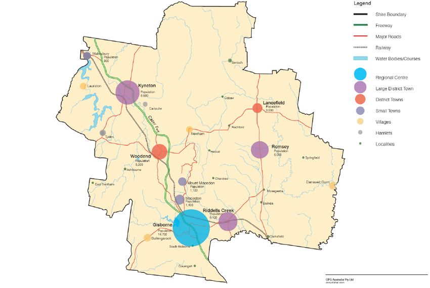
Macedon Ranges Protection Advisory Committee | Issues Paper | 11 March 2016

5    Options for protection of the Macedon Ranges ....................................................... 25
     5.1    Providing legislative protection for the Macedon Ranges .................................... 25
     5.2    Possible ways forward ........................................................................................... 26
     5.3    Strengthening the existing planning policy framework ........................................ 26
     5.4    Possible ways forward ........................................................................................... 27
     5.5    Strengthening the existing statutory planning framework ................................... 27
     5.6    Possible ways forward ........................................................................................... 27
     5.7    A separate authority.............................................................................................. 28
     5.8    Possible ways forward ........................................................................................... 28
     5.9    Additional consultation for planning decisions in the Macedon Ranges.............. 28
     5.10   Possible ways forward ........................................................................................... 29

Appendix A          Overview of the Victorian planning system
Appendix B          Localised Planning Statement September (2014)
Appendix C          Relevant Planning Policies

List of Tables
                                                                                                                          Page
Table 1     Summary of zone controls outside of townships.................................................. 15
Table 2     Current Planning Scheme Amendments ............................................................... 16

List of Figures
                                                                                                                          Page
Figure 1    Macedon Ranges Geographic profile, Source: Macedon Ranges
            Shire Council website .............................................................................................. 6
Figure 2    Settlement Plan (Source: Figure 1 of Macedon Ranges Shire
            Council Settlement Strategy, July 2011) ................................................................. 7
Figure 3    Evolution of Macedon Ranges Policy and Planning Framework ............................. 9
Figure 4    Statement of Planning Policy 8 Boundary (Source: Statement of
            Planning Policy No. 8, 1975) and Localised Planning Statement
            Boundary (Source:       Macedon Ranges Localised Planning
            Statement, September 2014) ................................................................................ 22
Macedon Ranges Protection Advisory Committee | Issues Paper | 11 March 2016
Glossary and abbreviations
Act Planning and Environment Act 1987
CVLAS Central Victoria Landscape Assessment Study
DELWP Department of Environment, Land, Water and Planning
EMP Environmental Management Plan
LPPF Local Planning Policy Framework
MSS Municipal Strategic Statement, a key part of the Local Planning
Policy Framework, and found in clause 21 of the Macedon Ranges
Planning Scheme
Peri-Urban Areas on the urban fringe, outside the urban growth boundary
RSP The Upper Yarra Valley and Dandenong Ranges Regional Strategy
Plan, referred to in Part 3A of the Act
SPP8 Statement of Planning Policy No. 8, Macedon Ranges and
Surrounds, 1975
SPPF State Planning Policy FrameworkMacedon Ranges Protection Advisory Committee | Issues Paper | 11 March 2016
The Advisory Committee
The Advisory Committee has been appointed by the Minister for Planning in accordance with
Terms of Reference. The purpose of the Committee as set out in the Terms of Reference is
to:
Provide advice on an appropriate policy to support changes to the legislative
framework to achieve protection for the Macedon Ranges and its unique
natural attributes, high environmental values and distinctive rural character
and townships. The Advisory Committee will also consider and report on
legislative options and statutory arrangements to achieve protection.
The Advisory Committee consists of:
• Brett Davis, Chair
• Sarah Carlisle
• Mandy Elliott
• Lisa Kendal
The Committee may also seek specialist advice as appropriate.
The Committee has been assisted by Elissa Bell.
The Issues Paper
The purpose of this Issues Paper is to inform submissions to the Advisory Committee. The
Issues Paper is not a statement of the views of the Committee or any other parties, but is
simply designed to ask questions and prompt discussions on relevant issues. The Committee
will hold hearings the week beginning 2 May 2016 with the view to finalising its advice to the
Minister by 15 July 2016.
Roundtable discussions
In order to inform this Issues Paper, the Committee conducted a number of roundtable
discussions with various stakeholders. The purpose of these discussions was to assist the
Committee in identifying issues only. The discussions were not a forum for submissions.
The first discussions were held in Gisborne on 9 and 10 February 2016, which provided the
Committee with some invaluable insights into the issues. Participants in these discussions
were:
• planning officers from the Macedon Ranges Shire Council
• Councillors of the Macedon Ranges Shire Council
• the Macedon Ranges Residents Association
• the Macedon Ranges Heritage Council
• representatives of the Macedon Ranges Accommodation Association
• representatives of the Ranges Equine Industry Network
• representatives of the Macedon Ranges Agribusiness Forum
• representatives of the Macedon Ranges Vignerons.
Page 1 of 40Macedon Ranges Protection Advisory Committee | Issues Paper | 11 March 2016
Members of the Committee also conducted discussions in Bendigo on 25 February 2016,
including with:
• planning officers from the regional Department of Environment, Land, Water and
Planning (DELWP)
• representatives of the Catchment Management Authority
• representatives of the Water Authorities
• representatives of the Registered Aboriginal Parties (RAPs).
Submissions to the Advisory Committee
Anyone with an interest in the protection of the Macedon Ranges is invited to consider the
issues raised and make submission. It would assist the Committee if submitters presented
their thoughts under the questions raised in this paper.
The Committee also welcomes submissions on issues that are not canvassed in this paper,
but that are relevant to the Committee’s Terms of Reference available at:
www.delwp.vic.gov.au/macedon-ranges-protection
Understanding the planning and policy framework that applies to the Macedon Ranges is key
to understanding the current protections for the Macedon Ranges, and to the options for
additional protections. To assist potential submitters who are less familiar with the Victorian
planning system and the planning and policy framework that applies, a brief explanation is
provided in Appendix A.
Submissions can be made online at:
www.delwp.vic.gov.au/macedon-ranges-protection
Please forward your written submissions by close of business on 15 April 2016.
It is anticipated that public hearings will commence the week beginning 2 May 2016.
For any questions please contact Elissa Bell in Planning Panels Victoria on (03) 9223 5317 or
planning.panels@delwp.vic.gov.au.
Page 2 of 40Macedon Ranges Protection Advisory Committee | Issues Paper | 11 March 2016
Executive Summary
This Issues Paper contains a discussion of the issues identified to date that the Committee
considers should be addressed in responding to the Macedon Ranges Protection Advisory
Committee Terms of Reference. It is based on background reading and research undertaken
by the Committee, and on roundtable discussions held by the Committee on 9 and 10
February 2016 in Gisborne and 25 February 2016 in Bendigo.
The primary purpose of this Issues Paper is to help guide submissions to the Committee. Set
out below are a number of propositions, in question form, on which the Committee invites
submissions. These propositions relate to the matters on which the Committee is required to
advise the Minister, as outlined in the Terms of Reference.
There may be issues that are relevant to the Terms of Reference that have not yet come to
the Committee’s attention, and are not dealt with in this Issues Paper. The Committee
welcomes submissions on these issues.
Background
Chapter 1 of this Issues Paper provides the background and context to the decision to
appoint an Advisory Committee to review protection for the Macedon Ranges. It provides an
overview of the key geographic and environmental factors that contribute to the quality of
life in the Macedon Ranges Shire.
Protections currently provided
Chapter 2 of this Issues Paper describes the current planning and policy framework for the
Macedon Ranges Shire as reflected in the Macedon Ranges Planning Scheme, and the role it
plays in protecting the key values and attributes of the Macedon Ranges. It discusses:
• the role and content of the various parts of the policy framework
• the role played by zones and overlays.
Key values and threats – why is protection needed?
Chapter 3 of this Issues Paper identifies the key values and attributes of the Macedon
Ranges region and discusses why protection of the Macedon Ranges is needed. It also
discusses the key threats to the Macedon Ranges that were identified through roundtable
discussions.
Geographic Area
Chapter 4 of this Issues Paper addresses the geographic area that the policy and legislative
controls should apply to. It discusses:
• some of the key geological features of the area
• current and past approaches to defining the policy area boundary
• options for defining the policy area boundary, including by reference to municipal
boundaries, geological or natural features, or other approaches.
Page 3 of 40Macedon Ranges Protection Advisory Committee | Issues Paper | 11 March 2016
A key issue discussed in chapter 4 is whether particular areas within the Shire should be
singled out for additional protection (as proposed in the draft Local Planning Statement,
which proposes additional protections in the area covered by ‘The Rock and the Ranges’
Policy Area).
Options for further protection of the Macedon Ranges
Chapter 5 of this Issues Paper discusses the issues, challenges and opportunities for the
protection of the key values and attributes of the Macedon Ranges, and outlines some
options for strengthening the protections (should this be needed). The options include:
• providing legislative protection, through amendments to the Act
• strengthening the existing planning policy framework for the Macedon Ranges
• strengthening the existing zones and overlays for the Macedon Ranges
• establishing a body with specific responsibility for the Macedon Ranges
• requiring additional oversight in relation to planning decisions that affect the Macedon
Ranges
• requiring additional consultation in relation to planning decisions that affect the
Macedon Ranges.
Other studies and strategies
Contained with the Appendices of this report are:
• Appendix A – An overview of the Victorian Planning System
• Appendix B – Localised Planning Statement September 2014
• Appendix C – Summary of Relevant Planning Policies.
Propositions intended to guide submissions
It would assist the Committee if submissions could address the following questions. They are
grouped under the broad headings above, and the table references those parts of the report
in which the issues related to the question are discussed. If you are not interested in all
issues, just respond to the questions that are of interest.
1. Is the current policy and planning framework adequate to address protection of the
Macedon Ranges?
2. Are there any aspects of policy relating to agricultural activities and protection of
productive land that do not adequately protect the values of the region?
3. Is the protection of water supply, tourism and recreation, and nature conservation,
as required by SPP8 adequately covered by current policy, zones and overlays?
4. What are the key values and attributes of the Macedon Ranges? Have they been
adequately identified in the current policy framework?
5. Are there any gaps in the threats to those values and attributes identified in the
current policy framework? If so, what is missing?
6. Is the protection of cultural heritage adequately covered by the current policy
framework?
Page 4 of 40Macedon Ranges Protection Advisory Committee | Issues Paper | 11 March 2016
7. Is the geographic extent of the policy area in the draft Localised Planning Statement
(2014) appropriate?
8. Do you support the inclusion of The Rock and The Ranges Policy Area as a ‘special
area’ warranting additional protection to the rest of the Shire?
9. What, if any, particular areas within the policy area are suitable for potential
growth or development, and why? How should these areas be defined?
10. What, if any, particular areas within the policy area are not suitable for any further
growth or development, and why? How should these areas be defined?
11. Is legislative protection required for the Macedon Ranges? Why?
12. What are the key principles that should underpin any legislative protection?
13. Is Statement of Planning Policy Number 8 still relevant, or does an updated policy
need to be developed?
14. Are there any values identified in Statement of Planning Policy Number 8 that were
not adequately reflected in Clause 22.01 or the draft Localised Planning Statement
(2014)?
15. What are the benefits of using a Localised Planning Statement to protect the key
values and attributes of the Macedon Ranges?
16. Should other zone or overlay controls be considered to achieve appropriate
protection? Please specify where and why.
17. Should a body be established with specific responsibility for protecting the values
and attributes of the Macedon Ranges from potential threats?
18. Should the body be a statutory authority or a non-statutory body?
19. What functions should the body have?
20. Are there other more appropriate ways of providing for additional oversight of
planning decisions affecting the Macedon Ranges (for instance, by the Minister for
Planning, or Parliament)?
Page 5 of 40Macedon Ranges Protection Advisory Committee | Issues Paper | 11 March 2016
1 Background
1.1 Macedon Ranges Protection Advisory Committee
The Terms of Reference require the Committee to:
…provide advice on an appropriate policy to achieve protection of the
significant values, attributes and character of the Macedon Ranges and
support changes to the legislative framework. The Advisory Committee will
also report on potential legislative options and statutory arrangements
available to implement the final policy.
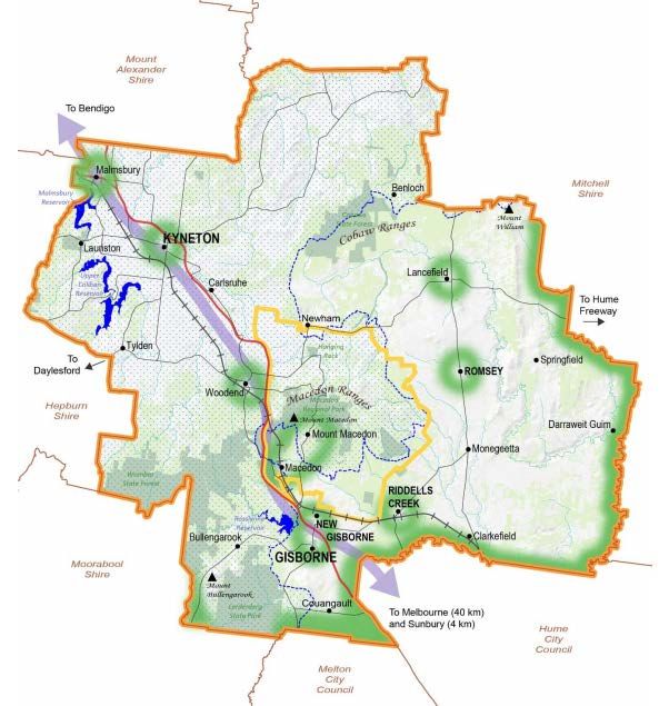
1.2 Macedon Ranges
The Shire of Macedon Ranges is located in central Victoria approximately 60 kilometres
north-west of Melbourne and spans approximately 1,747 square kilometres. It is part of an
extensive peri-urban region that surrounds the more established areas of Melbourne.
The Shire is renowned for its scenic landscapes, native forests and unique natural features
including Hanging Rock and Mount Macedon. The major towns and key geographical
features of the Macedon Ranges are shown in Figure 1.
Figure 1 Macedon Ranges Geographic profile, Source: Macedon Ranges Shire Council website
Page 6 of 40Macedon Ranges Protection Advisory Committee | Issues Paper | 11 March 2016
1.3 Settlement patterns
Macedon Ranges Shire is a semi-rural area, with a number of distinct townships and
settlements scattered across the Shire. The larger townships include Gisborne, Kyneton,
Lancefield, Macedon, Malmsbury, Mount Macedon, Riddells Creek, Romsey and Woodend.
Approximately 35 per cent of people in Macedon Ranges live outside a town boundary in a
rural or rural living setting.
The current estimated population for the Shire is approximately 46,349 people 1. The
population is forecast to grow to a total of 55,920 to 64,654 (20.64 per cent to 39.49 per
cent increase respectively) by 2036. Council’s recommended population projections
identified in its Settlement Strategy 2011 are to achieve the lower end of population growth
of 55,920 by 2036. Macedon Ranges Shire has little diversity in housing stock. Approximately
95 per cent of dwellings are detached houses, and approximately 54 per cent of households
are just one or two persons 2.
Figure 2 Settlement Plan (Source: Figure 1 of Macedon Ranges Shire Council Settlement
Strategy, July 2011)
1
http://forecast.id.com.au/macedon-ranges
2
ABS Census 2011
Page 7 of 40Macedon Ranges Protection Advisory Committee | Issues Paper | 11 March 2016
2 What protection is currently provided?
This Chapter describes the existing policy framework, Chapter 5 discusses options for
protection.
Terms of Reference 4(d) requires the Committee to advise on the extent to which the current
policy and framework addresses the identified threats issues and challenges to protecting the
area and identification of gaps in policy.
2.1 Evolution of Macedon Ranges policy and planning framework
The first comprehensive planning instruments for the Macedon Ranges were put in place in
the 1960s, with Interim Development Orders for the former Shires of Gisborne, Newham
and Woodend, Romsey and Kyneton.
The key developments in the policy and planning framework for the Macedon Ranges is
shown in Figure 3.
2.2 Policies specifically related to the Macedon Ranges area
(i) The significance of SPP8 in the policy and planning framework
Statement of Planning Policy No. 8 (SPP8) could be described as a corner stone of the policy
and planning framework for the Macedon Ranges. Although it no longer has any legislative
force in its own right, it remains a strong influence. Clause 21.01 of the Macedon Ranges
Planning Scheme states:
The Statement of Planning Policy No. 8 was adopted as State planning policy
in 1975 and has provided the basis of strategic planning in the Macedon
Ranges area since. Its provisions are as essential and relevant to the planning
of the Macedon Ranges area today as they were when the policy was
introduced.
(ii) The protections in SPP8
SPP8 prioritises the ‘protection and utilisation of the resources of the Policy Area for water
supply, tourism and recreation, and nature conservation’ (refer to clause 2.1 of SPP8).
Secondary attention, where appropriate, is paid to the value of the area for forestry and
agriculture (refer to clause 2.2 of SPP8).
SPP8 bans any ‘further subdivision for outward urban extension of Mount Macedon
settlement or for extension generally northerly of Macedon township’ (refer to clause 2.5 of
SPP8).
To assist in reconciling the interests of the State and local communities, SPP8 requires
special attention to be paid to ‘the institution of adequate programs to foster public
participation in the planning of the area’ (refer to clause 4.14 of SPP8).
Page 8 of 40Macedon Ranges Protection Advisory Committee | Issues Paper | 11 March 2016
2014 2015
Council adopted the Council adopted the Macedon
Macedon Ranges Ranges Localised Planning
Heritage Strategy Statement
1975 2003
The State government adopted The new format Macedon Ranges
Statement of Planning Policy Planning Scheme was introduced 2015
2003
No. 8 Macedon Ranges The former Shires of Gisborne, Council adopted the
1975 (SPP8) In the Rural Living
Kyneton, Newham and Woodend 2012 - 2014
Zone Strategy
and Romsey were amalgamated 2005 - 2006 2011 Council adopted Environmental
Council completed the Planning Council adopted the Macedon Management Plans for 8 public land
for a Sustainable Future Project Ranges Settlement Strategy reserves managed by Council
1975 2003 2009 2016
The late 1970's 2006 2006 2012 2013
2003 2010
The first planning schemes were 2015
Amendment Amendment Amendment Amendment Amendment Amendment
introduced for former Shires of C21 C8 Amendment
C19 C76 C66 C67 Part (2)
Gisborne, Newham and Woodend C84
and Romsey. 2006
Amendment
C48
2004 2011 2012 2015
Amendment Amendment Amendment Amendment
C38 C78 C67 (Part 1) C92
Amendments
C19 –Introduced heritage controls to various sites
C38 –Updated residential development policy
C21 –Implemented Macedon Ranges Rural Land Review 2002
C48 – Introduced Farming and Rural Conservation Zones
C8 –Implemented recommendations of the Residential and Industrial Land Review
C76 –Interim heritage protection Lancefield Town Centre Precinct
C78 –Interim heritage protection to Romsey Town Centre Precinct
C66 -Implemented Romsey Outline Development Plan and Residential Character Study & Design Guidelines
C67 (P1) & (P2)– Implemented Gisborne/New Gisborne Outline Development Plan
C92 –Introduced Macedon Ranges Shire Restructure Area Plans, 1999 (revised 2014)
C84 –Incorporated recommendations from Small Towns Study 2006, Report of Expert Review of Planning Policy 2008
and Macedon Ranges Settlement Strategy 2012
Figure 3 Evolution of Macedon Ranges Policy and Planning Framework
Page 9 of 40Macedon Ranges Protection Advisory Committee | Issues Paper | 11 March 2016
(iii) SPP8’s transition from State level policy to local policy
Every responsible authority who was preparing or amending a planning scheme was
required to ‘have due regard to’ any approved statement of planning policy, under section
8E of the Town and Country Planning Act 1961.
When the Town and Country Planning Act 1961 was repealed with the introduction of the
Planning and Environment Act 1987, statements of planning policy lost their legislative force,
as no transitional or savings provisions were included in the Planning and Environment Act
1987.
SPP8 remains part of the policy framework and is restated in clause 22.01 of the Macedon
Ranges Planning Scheme. Overall, clause 22.01 (like SPP8) seeks to achieve balance between
new developments and the existing natural features of the area, for the benefit of the State
and the local community.
The Committee notes that statements of planning policy (including SPP8) were developed
before the new format planning schemes were introduced in 2000. Many of the themes in
statements of planning policy have now been adopted as State policy requirements through
the State Planning Policy Framework (SPFF).
2.3 The Macedon Ranges Localised Planning Statement
(i) The role of Localised Planning Statements
Localised Planning Statements are a key tool for protecting distinctive areas in Victoria. They
are dealt with in clause 11.14 of the SPPF, the objective of which is to protect and enhance
the valued attributes of four specific areas, namely the Macedon Ranges, Bellarine
Peninsula, Mornington Peninsula and the Yarra Valley.
Clause 11.14 envisages Localised Planning Statements being prepared for each of the four
areas, which is also a key commitment of Plan Melbourne.
Clause 11.14 sets out a number of key strategies for all four areas:
• Recognise the significant geographic and physical features of these
areas
• Protect the identified key values and activities of these areas
• Support use and development where it enhances the valued
characteristics of these areas
• Recognise the important role these areas play in the state as tourist
destinations
• Avoid use and development that could undermine the long-term natural
or non-urban use of land in these areas
• Protect areas that are important for food production.
Once adopted, Localised Planning Statements become a reference document in all Victorian
Planning Schemes. They carry significant weight in the planning policy framework.
Planning ‘must consider’ the Localised Planning Statements (refer to clause 11.14 of the
Macedon Ranges Planning Scheme). Ministerial Direction No. 17 requires a planning
Page 10 of 40Macedon Ranges Protection Advisory Committee | Issues Paper | 11 March 2016
authority preparing an amendment affecting land identified in an adopted Localised
Planning Statement to:
• have regard to the relevant adopted Localised Planning Statement
• include in the explanatory report a discussion of how the amendment implements the
adopted Localised Planning Statement.
(ii) The draft Macedon Ranges Localised Planning Statement
The Macedon Ranges Localised Planning Statement, September 2014 (Appendix C) was
prepared and endorsed by Macedon Ranges Shire Council on 24 September 2014. It has not
yet proceeded past this point to be formally adopted by the Victorian Government and
included in the Macedon Ranges Planning Scheme.
2.4 State Planning Policy Framework
Several provisions of the SPPF specifically mention the Macedon Ranges. However, there are
many other provisions in the SPPF which, whilst not specifically naming the Macedon
Ranges, nevertheless provide policy protection for the Macedon Ranges. These are listed at
Appendix C.
2.5 Local Planning Policy Framework (LPPF)
The LPPF in the Macedon Ranges Planning Scheme is another key planning tool for the
protection of the values and attributes of the Macedon Ranges.
The LPPF in the Macedon Ranges Planning Scheme consists of:
• the Municipal Strategic Statement (MSS) in clause 21, and
• local planning policies in clause 22.
These are listed at Appendix C.
2.6 Zone and overlays
Zones and overlays are an important planning tool in the protection of the key values and
attributes of the Macedon Ranges. The zones and overlays that apply in the Macedon
Ranges are many and varied. The discussion below highlights zones and overlays that protect
some of the more significant attributes and values, and address some of the key threats of
the Macedon Ranges.
2.7 Agriculture
Within the Macedon Ranges Shire, agricultural land is subject to a number of zone and
overlay controls.
(i) Zones
A range of rural zones are applied, including:
• Farming Zone, which accounts for 48.6 per cent of Shire land
• Rural Conservation Zone, which accounts for 27.3 per cent of Shire land
Page 11 of 40Macedon Ranges Protection Advisory Committee | Issues Paper | 11 March 2016
• Rural Living Zone, which accounts for 9.2 per cent of Shire land 3.
The intent of these rural zones is detailed below 4.
The Farming Zone (FZ)
The Farming Zone (FZ) is the most commonly applied rural zone and is applied to
agricultural areas. The purpose of the FZ is to ensure that non-agricultural uses, particularly
dwellings, do not adversely affect the use of land for agriculture. The FZ is the most flexible
zone in terms of agricultural uses, and many agricultural uses do not require a permit. Uses
which do not require approval include agriculture, cattle feedlot (must be 1,000 head or
less), timber production, intensive animal husbandry requires approval. A permit is required
in the FZ for a single dwelling on lots less than 40 hectares (unless varied by a local
schedule). As many lots are smaller than 40 hectares, a permit is often required for a
dwelling in the FZ.
The Rural Conservation Zone (RCZ)
The Rural Conservation Zone (RCZ) is the main zone for rural areas of environmental
significance. Agriculture is allowed in the RCZ provided it is consistent with the
environmental and landscape values of the area. A planning permit is required for a dwelling
and the condition contained within the RCZ is that it must be the only dwelling on the lot.
This does not apply to the replacement of an existing dwelling, if the existing dwelling is
removed or altered (so it can no longer be used as a dwelling) within one month of the
occupation of the replacement dwelling.
The Rural Living Zone (RLZ)
The Rural Living Zone (RLZ) provides for residential use in rural areas and is typically applied
on the outskirts of settlements or township areas. The RLZ provides for agricultural activities
however emphasis is given to the protection of residential amenity.
The Rural Activity Zone (RAZ)
There are no areas of Rural Activity Zone (RAZ) in Macedon Ranges Shire. The Victorian
Planning Provisions outlined that the purpose of the RAZ is:
To provide for the use of land for agriculture. To provide for other uses and
development, in appropriate locations, which are compatible with agriculture
and the environmental and landscape characteristics of the area. To ensure
that use and development does not adversely affect surrounding land uses. To
provide for the use and development of land for the specific purposes
identified in a schedule to this zone.
To protect and enhance natural resources and the biodiversity of the area. To
encourage use and development of land based on comprehensive and
sustainable land management practices and infrastructure provision.
3
Albert Llausàs, Michael Buxton & Ruth Beilin (2015): Spatial planning and changing landscapes: a failure of
policy in peri-urban Victoria, Australia, Journal of Environmental Planning and Management
4
http://agriculture.vic.gov.au/agriculture/farm-management/business-management/planning-applications-in-
rural-areas/rural-zones-explained
Page 12 of 40Macedon Ranges Protection Advisory Committee | Issues Paper | 11 March 2016
Tourism, commercial and retail uses may be considered in the zone if they are compatible
with the agricultural, environmental and landscape qualities of the area. Agricultural uses in
the RAZ that require approval include: broiler farm; cattle feedlot lots (if more than 1,000
head); and intensive animal husbandry. A permit is required for a single dwelling in the RAZ 5.
Overlays
Rural and agricultural land may be subject to a range of overlay controls that impact on land
use and development in the Shire. These overlay controls are discussed in other sections of
this report, and include:
• environmental and landscape overlays relating to protection of areas of environmental
significance, vegetation and landscape significance
• heritage and built form overlays
• land management overlays relating to management of erosion management, land
subject to inundation and bushfire.
2.8 Water
Water supply catchment areas are included in the Rural Conservation Zone, Schedule 1 or 3
(RCZ1 and RCZ3) to protect water supply catchments. Amongst others, these schedules
identify the following values:
• To ensure that land use within water supply catchments, most
particularly proclaimed catchments, will not compromise water quality.
• To protect water quality in the proclaimed water supply catchments in
the south of the Shire including Merrmiu and Rosslynne.
The minimum subdivision area for land zoned RCZ1 or RCZ3 is 40 hectares.
Water supply catchment areas may also be subject to the Environmental Significance
Overlay, Schedules 4 or 5:
• The objective of Environmental Significance Overlay 4 – Eppalock Proclaimed Catchment
is (Clause 42.01):
− To ensure the protection and maintenance of water quality and water
yield within the Eppalock Water Supply Catchment Area as listed under
Section 5 of the Catchment and Land Protection Act 1994.
• The objectives of Environmental Significance Overlay 5 – Other Water Supply
Catchments are (Clause 42.01):
− To protect and utilise the resources of the area as a water catchment for
urban and local supply.
− To ensure the protection and maintenance of water quality and water
yield within the catchment areas.
− To ensure that land use activities and land management practices are
consistent with the conservation of natural resources.
− To control land use and development adjacent to water courses and
water storages.
5
http://agriculture.vic.gov.au/agriculture/farm-management/business-management/planning-applications-in-
rural-areas/rural-zones-explained
Page 13 of 40Macedon Ranges Protection Advisory Committee | Issues Paper | 11 March 2016
− To maintain and enhance the quantity and quality of water produced
within the catchment.
− To minimise the threat of pest plants and pest animals to agricultural
land and to water catchment areas.
2.9 Heritage
Places of heritage significance may be located on land zoned for a variety of purposes,
ranging from residential to rural.
The Heritage Overlay applies to specific sites or areas of local heritage significance, as well as
places included in the Victorian Heritage Register. The Heritage Overlay requires a planning
permit to subdivide land, alter, construct or demolish buildings or otherwise impact on the
significance of the heritage place.
There are currently 279 places of heritage significance listed in the schedule to the Heritage
Overlay of the Macedon Ranges Planning Scheme, including heritage precincts where
multiple individual properties are grouped together. The schedule to the Heritage Overlay
specifies the controls which may apply for each place.
Additional places may be included in the schedule once their heritage significance is
established.
2.10 Recreation and tourism
Specific sites designated for recreation and tourism activities may be subject to a range of
zone and overlay controls. The Public Conservation and Resource Zone is applied to the State
owned and managed land in the Mount Macedon Ranges.
Recreation and tourism activities may also be undertaken on land zoned for other purposes.
For example, bed and breakfast accommodation is allowable in the Farming Zone (subject to
conditions).
2.11 Settlement/subdivision
Council’s Municipal Strategic Statement (MSS) outlines:
…urban growth over the past decade has been the greatest in the south of the
Shire (in Gisborne, Romsey and Riddells Creek), with more modest growth
occurring in Woodend, Kyneton, Malmsbury, Lancefield, Macedon and Mount
Macedon. Gisborne and Kyneton continue to be the major population and
employment centres within the municipality. The Shire’s rural areas provide
important buffers between urban areas and the Melbourne metropolitan area.
In implementing the Macedon Ranges Settlement Strategy 2011, through Amendment C84
the following planning controls are applied in urban areas:
• the Township Zone in smaller settlements, and General Residential Zone in the larger
settlements
• a range of overlays to achieve specified protection outcomes, for example the Significant
Landscape Overlay in areas requiring landscape protection, and the Design and
Development Overlay in areas where patterns of settlement require management and
design controls
Page 14 of 40Macedon Ranges Protection Advisory Committee | Issues Paper | 11 March 2016
• the Development Plan Overlay is applied to new greenfield development areas to ensure
coordinated development and high quality design responses
• the Restructure Overlay is used over settlements where consideration of environmental
constraints and infrastructure is to be considered when determining lot layout and sizes
• the Development Contributions Plan Overlay is applied when planning is required to
secure and deliver infrastructure.
Schedules to a number of zones that apply in the Macedon Ranges limit the minimum lot
size for any further subdivision. Within the township settlement boundaries this includes the
General Residential Zone and Low Density Residential Zone. Outside the township
boundaries, this includes zones such as the Rural Living Zone, the Rural Conservation Zone
and the Farming Zone.
In many cases, the minimum lot size outside the township settlement boundaries is 40
hectares.
Table 1 Summary of zone controls outside of townships
Zone control Default minimum lot size Lot sizes permitted under
(unless alternative is specified schedule (ha)
in schedule) (ha)
Rural Living Zone 2 0.4, 0.5, 1, 2, 8, 40
Rural Conservation 40 40, 50
Zone
Farming Zone 40 40, 100
Rural Activity Zone Nominated by the planning n/a
authority in schedule to the
zone
2.12 Landscapes
Many areas with the Shire that include significant landscape features are included in the
Rural Conservation Zone discussed above.
In addition, the following overlay controls are of particular relevance:
• Environmental Significance Overlay (clause 42.01)
• Vegetation Protection Overlays (clause 42.02)
• Significant Landscape Overlays (clause 42.03)
2.13 Current planning scheme amendments for Macedon Ranges
Macedon Ranges Shire Council has prepared several planning scheme amendments which
are currently on exhibition, or have been referred to a panel. They are set out in Table 2.
Some amendments propose to amend or add to the LPPF in the Macedon Ranges Planning
Scheme, others propose to rezone land within the Shire or to apply additional overlay
controls, and others propose the addition of further schedules to provide more detailed
planning controls for land in some zones.
Page 15 of 40Macedon Ranges Protection Advisory Committee | Issues Paper | 11 March 2016
Table 2 Current Planning Scheme Amendments
Amendment About Status
C098 Implements recommendations of Submissions closed 23 October
Woodend town structure plan and Panel dates – DH 1 Feb, PH 29 Feb
neighbourhood character study, 2014
C099 Kyneton Structure Plan Directions Hearing 13 Jan
C103 Rezone land from PPRZ to GRZ1 Directions Hearing 13 Jan
C105 Establishes Kyneton Horse Training and Directions Hearing 13 Jan
Equine services precinct
C100 Implements recommendations of Panel appointed, no dates set
Riddles Creek structure plan and
neighbourhood character study, 2014
C102 Rezoning Lot from Farm Zone to Low Exhibition 14 Jan 2016
Density Residential Planning
C107 Woodend Commercial Rezoning Report submitted February 2016
C110 Implement the In the Rural Living Zone Exhibition 19 November 2015
Strategy by amending schedules to the
Rural Living Zone in selected locations
to provide additional lots and apply the
Development Plan Overlay
2.14 Possible ways forward
The Committee invites submissions addressing the following questions:
1. Is the current policy and planning framework adequate to address protection of the
Macedon Ranges?
2. Are there any aspects of policy relating to agricultural activities and protection of
productive land that do not adequately protect the values of the region?
3. Is the protection of water supply, tourism and recreation, and nature conservation,
as required by SPP8 adequately covered by current policy, zones and overlays?
Page 16 of 40Macedon Ranges Protection Advisory Committee | Issues Paper | 11 March 2016
3 Why is protection needed?
This section of the Issues Paper discusses the key values and attributes of the Macedon
Ranges, and the key threats and areas under threat that have been identified so far.
Terms of Reference 4(b) requires ‘an assessment of why protection is needed, including
identification of key values and attributes that contribute to the significance of the Macedon
Ranges and the key threats and areas that are under threat’.
3.1 General recognition of the area’s values and attributes
Planning policy has long recognised the special and unique values and attributes of the
Macedon Ranges. Currently, Plan Melbourne states:
…the area contains valued environmental and cultural features. It has tourism
assets such as the iconic Hanging Rock, historic townships, and equine and
wine industries that attracted tourism and economic activity.
The recognition of the Macedon Ranges in Plan Melbourne reflects earlier statements in
State level planning policy. The explanatory report to SPP8 states:
This range and its surrounds represent one of the most outstanding natural
areas to the north west of Melbourne. The area’s importance derives
principally from its proximity to Melbourne and its abundance of natural
attributes.
3.2 Environmental assets and natural resources
Broadly, Macedon Ranges’ environmental assets natural resources are a key attribute. These
environmental assets natural resources include significant water catchments (including
extensive areas of declared special water supply catchments), high quality soils, significant
biodiversity and distinctive landforms and geological features. As well as giving the area a
unique sense of ‘place’, these natural resources provide the local and broader communities
with water supply, recreational and tourist spaces, and opportunities for forestry and
agriculture.
The variations in geology, landform, soil, sand and climate are reflected in the marked
changes of vegetation throughout the policy area. Over very short distances, dry forests and
woodland merge into wet open forest, providing for a diversity of fauna. The area retains
rich native biodiversity with extensive areas of remnant native vegetation, including
significant forested areas, which are an integral part of the area’s unique landscape. Key
features include Mount Macedon and the Macedon Regional Park, the Wombat State Forest
around Woodend and the Cobaw Ranges, Bald and Black Hill Reserves, and Mount William.
The area also features significant exotic vegetation, including boulevards of tree plantings in
many towns, Avenues of Honour in Macedon and Woodend, and significant ornamental
gardens on Mount Macedon that are fundamental to local landscape quality 6.
6
www.mrsc.vic.gov.au
Page 17 of 40Macedon Ranges Protection Advisory Committee | Issues Paper | 11 March 2016
3.3 Geology and Landscapes
The Shire’s high quality natural landscapes contribute significantly to the character of the
area.
The Macedon Ranges form part of the Great Dividing Range and are the remainder of more
extensive Upper Devonian volcanic granite formations, which overlook the surrounding
region. Its maximum elevation is approximately 1000 metres at Mount Macedon and Camels
Hump, with lower parts of the formation being at 600-770 metres in the Black Forest at the
western foot of Mount Macedon, and 490-550 metres in areas north of Macedon Ranges.
The Cobaw Range and Mount William in the north and north-east reach elevations of over
750 metres, while the lowest point is at Deep Creek in the south east at an elevation of 160
metres.
The Department of Environment, Land, Water and Planning (DELWP) is currently preparing
the Central Victoria Landscape Assessment Study (CVLAS). The study covers the Macedon
Ranges Shire, and a draft report was issued for community comment in 2015.
According to the CVLAS – Community Newsletter 2, March 2015, two Landscape Character
Types can be found in Macedon Ranges Shire:
• Victorian Volcanic Plains (VP) – defined by a flat to undulating basaltic plain scatter with
volcanic features. The distinctive volcanic cones and rises that punctuate the horizon are
key features; and
• Rolling Foothills (RF) – characterised by rolling pastures and volcanic hills, dissected by
ridgelines and sharp crests.
The Macedon Ranges Shire includes three sites of regional significance and one of state
significance:
• Mount Aitken, Mount Gisborne and Cobaw Ranges (regional significance)
• Mount Macedon, including Hanging Rock and Jim Jim (state significance).
3.4 Cultural Heritage and Traditional Land Ownership
The area has a rich aboriginal history. Many place names throughout the Shire relate to
traditional ownership of the land; Barringo, Darraweit Guim, Jim Jim, Konagaderra Creek,
Monegeetta, Willimigongon Creek and Wurundjeri Creek.
The Aboriginal Heritage Act 2006 recognises Aboriginal people through Registered
Aboriginal Parties as the primary guardians of Aboriginal cultural heritage. There are three
Registered Aboriginal Parties in the Macedon Ranges Shire who have lived in the area for
more than 25,000 years. These are the Dja Dja Wurrung, the Taungurung and Wurundjeri.
The Advisory Committee has been able to meet in a preliminary discussion with
representatives of Dja Dja Wurrung and Taungurung groups but has not yet been able to
meet with the Wurundjeri.
Native title in Victoria is dealt with under the Traditional Owner Settlement Act 2010. This
Act provides for out-of-court settlement of native title and allows the State Government to
recognise traditional owner groups and their rights over Crown Land.
Page 18 of 40Macedon Ranges Protection Advisory Committee | Issues Paper | 11 March 2016
The Dja Dja Wurrung Clans Aboriginal Corporation represents the interests of the Dja Dja
Wurrung traditional owner group, recognised by the 2013 settlement agreement. The
Corporation has developed a ‘Country Plan’ which outlines the strategic goals of the Dja Dja
Wurrung in the management of land and waters comprising their ‘Country’ as well as
consultation principles for State or third parties.
Part of the 2013 settlement with the Dja Dja Wurrung includes an ongoing State
commitment to engage with the Corporation in natural resource management (the
‘participation strategies‘).
The Advisory Committee understands a key tenant of the agreement is for the State and
Traditional Owners to work in partnership. The Committee understands the Taungurung
and Wurundjeri are in various stages of the process of achieving their own such settlements.
The Committee invites the Registered Aboriginal Parties to make submission on the issues
raised within this report.
3.5 Built form heritage
The Macedon Ranges has a significant collection of heritage towns, with largely intact
streetscapes from the gold rush era of the early to mid-1800s. Many of the region’s towns
were established along historic transport corridors and played an important role in the
Victorian gold rush, linking Melbourne to central and northern Victoria.
Typical of many towns are bluestone buildings, historic churches and fountains, old
homesteads and stables, wool and flour mills, and hay and grain stores. Some towns are also
known for their historic streetscapes, such as Piper Street in Kyneton and High Street in
Woodend.
Considered to be the most significant war memorial in Victoria, second only to the Shrine of
Remembrance, the Mount Macedon Memorial Cross pays tribute to all those who served in
wars and conflicts 7. Tree-lined Avenues of Honour can be found in several towns including
Woodend, Macedon and Kyneton in remembrance of those who volunteered, fought or died
in wars and conflicts including both World Wars, Korea and Vietnam 8. Botanic Gardens of
heritage significance can be found in Malmsbury, Kyneton and Gisborne 9.
3.6 Recreation and Tourism
Tourism is one of the main industries in the Shire, generating approximately $275 million
annually 10. The Shire is located within close proximity to Melbourne and Tullamarine
airport, and offers opportunities for day trips and overnight stays. In addition to natural and
landscape features, the Shire also offers a range of cultural events that attract visitors.
3.7 Key threats
Population growth in the Macedon Ranges area brings with it the threat of increased
development which can directly and indirectly impact natural assets.
7
http://parkweb.vic.gov.au/explore/parks/macedon-r.p./things-to-do/mermorial-cross-reserve
8
http://www.avenuesofhonour.org/
9
www.mrsc.vic.gov.au
10
www.mrsc.vic.gov.au
Page 19 of 40Macedon Ranges Protection Advisory Committee | Issues Paper | 11 March 2016
The popularity of the area for tourism and recreation, coupled with improved transport links
from Melbourne and Bendigo, has the potential to increase threats to the area’s natural and
tourism assets. Visitor numbers are increasing, and there is an increasing pressure to provide
additional access routes and visitor facilities within the Ranges.
Environmental risks (both human induced and natural) also pose a threat to the significant
attributes and values of the Macedon Ranges.
Key environmental threats to the area include bushfire and flooding, the risks of which are
anticipated to increase with the impacts of climate change, and with increasing population
densities in the area. These present natural disaster/emergency management risks which
must be carefully managed.
3.8 Threats identified in the consultation workshops
During the consultation workshops, participants identified various threats to the area, which
the Committee has grouped into broad themes:
• population growth and increased development
• threats to water catchments
• environmental/natural disaster threats
• gaps/changes in the policy environment and its implementation
• threats to the local economy
• ‘hidden’ cultural heritage not captured by controls
• complex planning controls.
3.9 Possible ways forward
The Committee invites submissions to address the following questions:
4. What are the key values and attributes of the Macedon Ranges? Have they been
adequately identified in the current policy framework?
5. Are there any gaps in the threats to those values and attributes identified in the
current policy framework? If so, what is missing?
6. Is the protection of cultural heritage adequately covered by the current policy
framework?
Page 20 of 40Macedon Ranges Protection Advisory Committee | Issues Paper | 11 March 2016
4 What geographic area should the policy and
legislative controls apply to?
Terms of Reference 4(a) requires the Committee to advise on ‘the extent of the geographic
area the final policy and legislative controls should apply to’.
4.1 Current policy area boundaries
When reviewing the current policy area boundaries, the Committee notes that the policy
area of the draft Localised Planning Statement (2014) is significantly larger than the policy
area of SPP8, and that the ‘Rock and Ranges Policy Area’ is not an exact match with any
existing zone or overlay applied to the area, including the Significant Landscape Overlay 1 –
Mountain Ranges and Features.
Figure 4 highlights the different extent of boundaries between the SPP8 and Localised
Planning Statement (2014).
Statement of Planning Policy No. 8 (SPP8) used a combined approach, with consideration of
land features and municipal boundaries. The explanatory report to SPP8 stated:
The Policy Area is bounded approximately by the Cobaw Range and Mount
William Range in the north and northeast respectively, Mount Bullengarook in
the south-west and Bulla Shire in the southeast. This area encompasses
portions of the Shires of Kyneton, Bacchus Marsh, Gisborne, Romsey and
Newham-Woodend, but by far the largest area of land falls within the latter
three shires.
Page 21 of 40Macedon Ranges Protection Advisory Committee | Issues Paper | 11 March 2016
PP8 Boundary LPS Boundary
Figure 4 Statement of Planning Policy 8 Boundary (Source: Statement of Planning Policy No. 8, 1975) and Localised Planning Statement Boundary
(Source: Macedon Ranges Localised Planning Statement, September 2014)
Page 22 of 40Macedon Ranges Protection Advisory Committee | Issues Paper | 11 March 2016
Under the draft Localised Planning Statement 2014, it is proposed to include the entire Shire
within the policy area, with the Rock and Ranges Policy Area singled out for additional
protection. A copy of the draft Localised Planning Statement (2014) is provided in Appendix
B of this report.
Council’s report to adopt the Localised Planning Statement in September 2014 stated:
The new policy statement includes all the natural assets in the Shire, rather
than having areas such as the Wombat Forest split by a policy area line (as in
the original SPP8 area). As some 40 years have passed, the natural assets
within the now Shire boundaries are considered of equal importance. The only
exceptions are the unique qualities of the Macedon Ranges and Hanging Rock
and their immediately surrounding environs.
The Range and The Rock area has been included within the Statement map
that has boundaries derived from a clear methodology which defines the
Macedon Ranges and surrounding areas as being of particular significance.
This new policy area is formulated on the following methodology:
• The iconic geological and landscape significance of the Macedon Ranges
and Hanging Rock; combined with
• The Rural Conservation Zone boundary surrounding these assets;
combined with
• The high quality vegetation and biodiversity assets of the area;
combined with
• The water supply assets of the Ranges and the need for careful
management of water runoff and quality; combined with the high fire
risk and need to manage this.
4.2 Approaches to policy boundary definition
There are several ways in which policy area boundaries can be identified. For instance, it
could be defined by reference to:
• municipal boundaries
• particular geographic or land feature boundaries
• planning control boundaries, for example existing protection overlays such as the
Environmental Significance Overlay (as these identify key areas of significance requiring
protection)
• natural assets mapping, for example landscape, visual or bioregional assessments
• built asset or management boundaries, for example roads
• community use and values.
Alternatively, a landscape, visual or bioregional assessment could be undertaken and form
the basis of any boundary for area to which the final policy and legislative controls apply.
Page 23 of 40You can also read