Official Community Plan Bylaw No. 4985, 2018, Amendment Bylaw No. 5120, 2021 - District of West Vancouver
←
→
Page content transcription
If your browser does not render page correctly, please read the page content below
4.

              District of West Vancouver

Official Community Plan Bylaw No. 4985, 2018,
       Amendment Bylaw No. 5120, 2021

                   Effective Date:

                                           4240962v1

                          5
District of West Vancouver

   Official Community Plan Bylaw No. 4985, 2018,
          Amendment Bylaw No. 5120, 2021

                                      Table of Contents

Part 1   Citation..................................................................................................... 1
Part 2   Severability .............................................................................................. 1
Part 3   Amends Policy Section 2 [Community-Wide Directions] .......................... 1
Part 4   Amends Schedule ii [Area-Specific Policies & Guidelines] ...................... 2
Part 5   Offence and Penalty ................................................................................ 3
 Schedule A – Map 2. Marine Drive Transit Corridor ............................................. 5
 Schedule B – Map 3. Local Area Planning Boundaries......................................... 6
 Schedule C – Map 6. Horseshoe Bay Local Area Planning Boundary Map ........... 7
 Schedule D – Residential Area Designations Key Map ........................................ 8
 Schedule E – Commercial Development Permit Area Designations...................... 9
 Schedule F – Horseshoe Bay Local Area Plan and Design Guidelines ............... 10

                                                                                                            4240962v1

                                                        6
Official Community Plan Bylaw No. 4985, 2018, Amendment Bylaw No. 5120, 2021        1

                            District of West Vancouver

   Official Community Plan Bylaw No. 4985, 2018,
          Amendment Bylaw No. 5120, 2021

  A bylaw to adopt the Horseshoe Bay Local Area Plan and Design Guidelines.

Previous amendments: Amendment bylaws 5008, 5045, 5054, 5057, 5064, 5074
and 5076.

WHEREAS the Council of The Corporation of the District of West Vancouver
deems it expedient to provide for the designation of a development permit area
for the purposes of revitalization of an area and establishment of objectives for
the form and character of development;

NOW THEREFORE, the Council of The Corporation of the District of West
Vancouver enacts as follows:

Part 1 Citation
1.1   This bylaw may be cited as Official Community Plan Bylaw No. 4985,
      2018, Amendment Bylaw No. 5120, 2021.

Part 2 Severability
2.1   If a portion of this bylaw is held invalid by a Court of competent
      jurisdiction, then the invalid portion must be severed and the remainder of
      this bylaw is deemed to have been adopted without the severed section,
      subsection, paragraph, subparagraph, clause or phrase.

Part 3 Amendment to Section 2 [Community-Wide
Directions]
Schedule A of Official Community Plan Bylaw No. 4985, 2018, is amended by:

                                                                            4240962v1

                                        7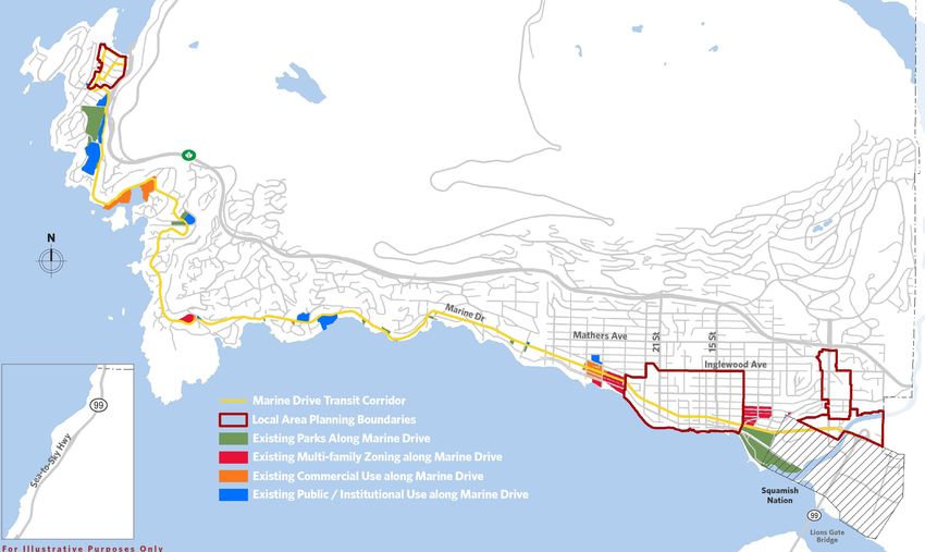
Official Community Plan Bylaw No. 4985, 2018, Amendment Bylaw No. 5120, 2021       2

3.1   Replacing “Map 2. Marine Drive Transit Corridor” and replacing it with the
      map as shown on Schedule A attached to this bylaw;

3.2   Replacing provision 2.1.12 with:
      Implement local area plans for the following areas:
         a. Marine Drive Local Area Plan (estimated 500-750 housing units,
            see Map 4); and
         b. Horseshoe Bay Local Area Plan (estimated 200-300 net new units,
            see Map 6).

3.3   Replacing provision 2.1.13 with:
      Create capacity for an estimated 1,500–1,800 net new housing units
      through local area plans (see Map 3) for the following areas, subject to
      provision 2.1.14 of this plan:
          a. Ambleside Municipal Town Centre (1,000–1,200 estimated net new
             units); and
          b. Taylor Way Corridor (500–600 estimated net new units).

3.4   Replacing “Map 3. Local Area Planning Boundaries” and replacing it with
      the map as shown on Schedule B attached to this bylaw;

3.5   Replacing “Map 6. Horseshoe Bay Local Area Planning Boundary” and
      replacing it with the map as shown on Schedule C attached to this bylaw;

Part 4 Amendment to Schedule ii [Area-Specific
Policies & Guidelines]
Schedule A of Official Community Plan Bylaw No. 4985, 2018, is amended by:

4.1   Replacing “Residential Area Designations” key map with the map as
      shown on Schedule D attached to this bylaw.

4.2   Deleting “Duplex Area Development Permit Area Designation Map BF-B
      11 (3 of 4)” and renumbering the remaining BF-B 11 maps and
      renumbering reference to the maps.

4.3   Deleting “Guidelines BF-C 6” for “Horseshoe Bay Neighbourhood Centre”
      in their entirety.

4.4   Replacing “Commercial Development Permit Area Designations” key map
      with the map as shown in Schedule E attached to this bylaw.

4.5   Adding “Horseshoe Bay Local Area Plan and Design Guidelines”, attached
      as Schedule F to this bylaw, following section “Marine Drive Local Area

                                                                         4240962v1

                                         8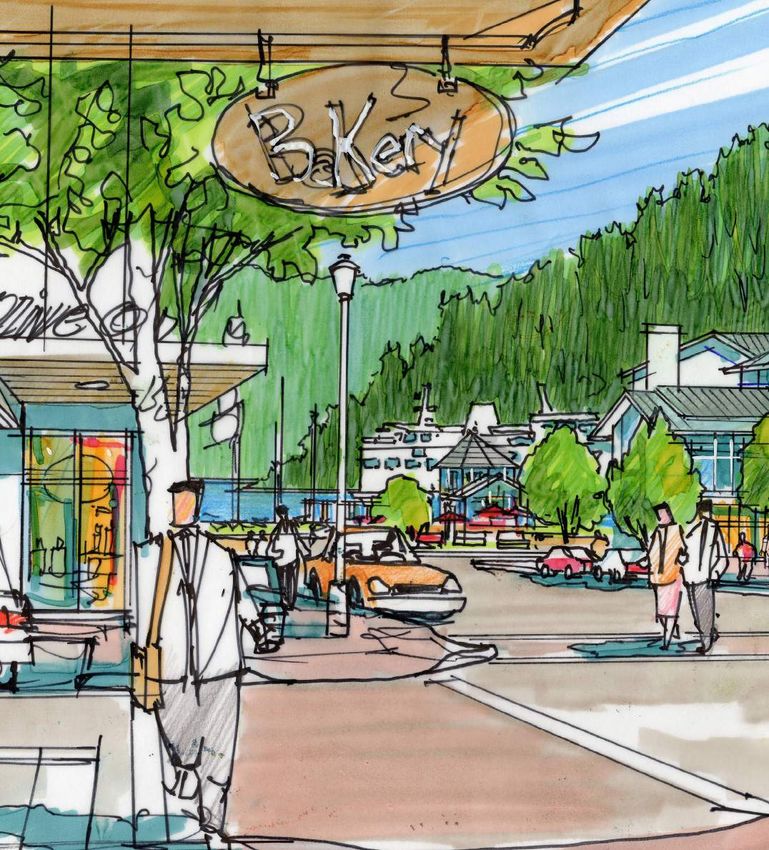
Official Community Plan Bylaw No. 4985, 2018, Amendment Bylaw No. 5120, 2021       3

      Plan and Design Guidelines”.

4.6   Reconciling the “Area-Specific Policies & Guidelines” table of contents
      accordingly.

Part 5 Offence and Penalty
5.1   Every person who violates a provision of this bylaw, or who consents,
      allows or permits an act or thing to be done in violation of a provision of
      this bylaw, or who neglects to or refrains from doing anything required to
      be done by a provision of this bylaw, is guilty of an offence and is liable to
      the penalties imposed under this bylaw, and is guilty of a separate offence
      each day that a violation continues to exist.

5.2   Every person who commits an offence is liable on summary conviction to
      a fine or to imprisonment, or to both a fine and imprisonment, not
      exceeding the maximum allowed by the Offence Act.

Schedules
Schedule A – Map 2. Marine Drive Transit Corridor
Schedule B – Map 3. Local Area Planning Boundaries
Schedule C – Map 6. Horseshoe Bay Local Area Planning Boundary
Schedule D – Residential Area Designations Key Map
Schedule E – Commercial Development Permit Area Designations
Schedule F – Horseshoe Bay Local Area Plan and Design Guidelines

                                                                            4240962v1

                                        9
Official Community Plan Bylaw No. 4985, 2018, Amendment Bylaw No. 5120, 2021    4

READ A FIRST TIME (MAJORITY VOTE IN THE AFFIRMATIVE) on
May 10, 2021

PUBLICATION OF NOTICE OF PUBLIC HEARING on

PUBLIC HEARING HELD on

READ A SECOND TIME (MAJORITY VOTE IN THE AFFIRMATIVE) on

READ A THIRD TIME (MAJORITY VOTE IN THE AFFIRMATIVE) on

ADOPTED by the Council (MAJORITY VOTE IN THE AFFIRMATIVE) on .

                                                                         Mayor

                                                              Corporate Officer

                                                                         4240962v1

                                      10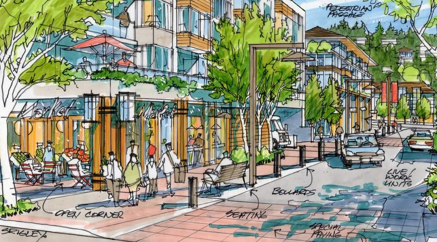
Official Community Plan Bylaw No. 4985, 2018, Amendment Bylaw No. 5120, 2021   5
Schedule A – Map 2. Marine Drive Transit Corridor

                                                11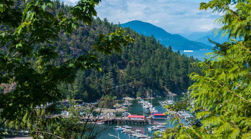
Official Community Plan Bylaw No. 4985, 2018, Amendment Bylaw No. 5120, 2021   6
Schedule B – Map 3. Local Area Planning Boundaries

                                                12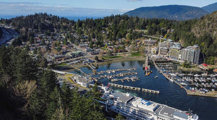
Official Community Plan Bylaw No. 4985, 2018, Amendment Bylaw No. 5120, 2021   7
Schedule C – Map 6. Horseshoe Bay Local Area Planning Boundary

                                                13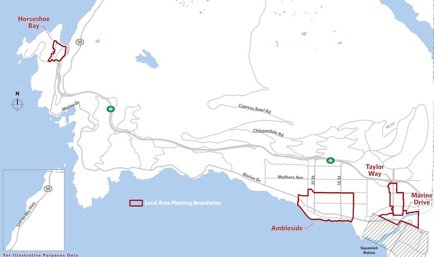
y
wa
Ca
p
gh
ila
Hi
no
ky
wood Ave
S
St
o-
La
21st St
Ln
22nd St
a-t
20th St
ke
Se
Sherwood
Gordon Ave
99
Rec.
Centre
Esquimalt Ave
Eagle Lake
Bel Ma
lev rine
19th St
FUTURE ue Dr
Ar Ave
NEIGHBOURHOODS gy
le
Drive
Inset
BLOCK BOUNDED BY
ESQUIMALT, 20th,
Bowl Road FULTON & 21st
e
ress
Cyp
1
Marin
99
Schedule D – Residential Area Designations Key Map
WHITBY ESTATES
14
2170 CHAIRLIFT ROAD
1
N 99
Upper
Levels
W E DEER RIDGE WEST
Drive
Marine ESKER LANE
S 1
99
Mathers Highway
Ave.
15th Street
Lighthouse TUDOR GARDENS
1A
22nd Street
22nd ST. and GORDON AVE. 99
Park ALTAMONT
LOWER CAULFEILD
KLAHANIE PARK 1
COSERVATION AREA NEIGHBOURHOOD
Official Community Plan Bylaw No. 4985, 2018, Amendment Bylaw No. 5120, 2021
KIWANIS SITE
Sunset
Marina
Taylor Way
Future Neighbourhoods
Duplex Development Permit Area AMBLESIDE APARTMENT AREA
Area with Guidelines for Development
99 Heritage Conservation Area
e
SUNSET Ambleside Apartment Area
dg
HIGHLANDS
Residential Area Designations
Bri
Multiple Family Development Permit Area
ate
( Key map only, for specific boundaries
G
n's
(see inset) see Guidelines section )
Lio
8y.
Hw
Sewell’s Landing Ca
Horseshoe Bay Marina pi
la n
o
ky
La
o-S
ke
a-t
Se
99
1
Eagle Lake
e
e Driv
Thunderbird Marina
5776 Marine Drive
Marin
5854 Marine Drive
5775 Marine Drive
1
5908 Marine Drive 99
Cypress
Bowl
Roa
15
d
CAULFEILD NEIGHBOURHOOD CENTRE
CHIPPENDALE
3690 Westmount Road
PANORAMA
Schedule E – Commercial Development Permit Area Designations
N 1
Eagle Harbour Marina 4360/70 Upper 99
5750 Eagle Harbour Road Marine Drive Levels
W E Highway
S Ma DUNDARAVE VILLAGE
rin
e NEIGHBOURHOOD CENTRE 1
99
Driv Mathers Ave.
e
15th Street
Lighthouse 1A
22nd Street
3390/96 Marine Drive 99
1
Park
2168/96 Clyde Avenue
Official Community Plan Bylaw No. 4985, 2018, Amendment Bylaw No. 5120, 2021
4917 Marine Drive Marine Drive
Taylor Way
2203 Marine Drive
2220/32 Marine Drive
Sunset Marina Commercial Development Permit Area
34 Sunset Beach AMBLESIDE TOWN CENTRE
Commercial Land Use Contract Area ( Not D.P.A.)
Marine Commercial Development Permit Area
99
ge
Local Commercial Development
Commercial Development Permit Area
rid
B
te
Permit Area
Ga
Designations
n's
Area North of Marine Drive Local Area Plan and Design Guidelines
Lio
Horseshoe Bay ( Key map only, for specific boundaries see Guidelines section )
9Official Community Plan Bylaw No. 4985, 2018, Amendment Bylaw No. 5120, 2021
Schedule F – Horseshoe Bay Local Area Plan and Design Guidelines
Horseshoe Bay
Local Area Plan and Design Guidelines
April 2021
16Contents
Introduction
1.1 Purpose.........................................................................................................................1
1.2 Background.................................................................................................................2
1.3 Application & Scope.................................................................................................3
1.4 Organization...............................................................................................................4
Vision & Principles
2.1 Vision...........................................................................................................................5
2.2 Principles.....................................................................................................................7
Land Use Designations & Policies
3.1 Building to Principles.............................................................................................. 13
3.2 Neighbourhood & Village...................................................................................... 15
3.3 Use, Density & Height............................................................................................ 15
3.4 Neighbourhood Designation................................................................................. 17
3.5 Village Designation................................................................................................. 19
3.6 Land Use Policies.................................................................................................... 22
General Guidelines
4.1 Application ............................................................................................................. 29
4.2 Site Planning............................................................................................................ 30
4.3 Site Design................................................................................................................32
4.4 Building Form.......................................................................................................... 34
Sub-Area Guidelines
5.1 Application................................................................................................................37
5.2 Neighbourhood....................................................................................................... 38
5.3 Village....................................................................................................................... 39
5.4 Waterfront............................................................................................................... 42
5.5 “Little Bay”............................................................................................................... 43
5.6 Royal, Keith & Nelson............................................................................................44
Public Realm Guidelines
6.1 Application.............................................................................................................. 47
6.2 Public Realm............................................................................................................ 48
6.3 Connectivity............................................................................................................ 50
Implementing the Plan’s Vision
7.1 Community Benefits................................................................................................53
7.2 Administration........................................................................................................ 54
17List of Figures
Figure 1.1 Horseshoe Bay LAP and DPA....................................................................2
Figure 3.1 Land Use Designations............................................................................14
Figure 3.2 Land Use Designations - Neighbourhood............................................ 16
Figure 3.3 Land Use Designations - Village............................................................ 18
Figure 3.4 Transect of land use designations looking west................................ 20
Figure 3.5 Designations support housing and design diversity......................... 24
Figure 3.6 Horseshoe Bay Park Revitalization Concept Plan.............................. 27
Figure 4.1 General Guideline Applicability............................................................ 29
Figure 4.2 Artist’s illustration of Infill designated area........................................ 31
Figure 4.3 Artist’s illustration of Multiplex designated area...............................33
Figure 4.4 Artist’s illustration of Village Heart designated area........................35
Figure 5.1a Neighbourhood sub-area ...................................................................... 38
Figure 5.1b Village sub-area ...................................................................................... 39
Figure 5.1c Waterfront sub-area ............................................................................... 42
Figure 5.1d “Little Bay” sub-area .............................................................................. 43
Figure 5.1e Royal Avenue sub-area ..........................................................................44
Figure 5.1f Keith Road sub-area ...............................................................................44
Figure 5.1g Nelson Avenue sub-area .......................................................................44
Figure 5.2 Artist’s illustration of Rowhouse designated area............................ 38
Figure 5.3 Artist’s illustration of Bay Street........................................................... 39
Figure 6.1 Artist’s illustration of “Little Bay”......................................................... 47
Figure 6.2 Streetscape................................................................................................ 48
Figure 6.3 Connectivity............................................................................................... 49
Figure 6.4 Illustrative Neighbourhood Section....................................................... 51
Figure 6.5 Illustrative Village Section....................................................................... 51
18This page left intentionally blank
19Introduction
1.1 Purpose
The following Horseshoe Bay Local Area Plan and Design Guidelines (LAP) forms part of the District’s Official
Community Plan (OCP). Its intent is to establish a framework to guide gradual and positive change that strengthens
the identity (sense of place), livability, and success of this unique village and neighbourhood. The LAP outlines the
long-range vision for Horseshoe Bay as a whole, and it provides more detailed regulations and guidelines to shape
the form and character of new development. It further confirms a local and contextually-specific response to District-
wide OCP planning objectives around housing diversity, economic vibrancy, connectivity and mobility, environmental
sustainability, and public spaces that support our social well-being.
INTRODUCTION 1
201.2 Background
Horseshoe Bay is located on the traditional territory of the Coast Salish peoples, including the Squamish, Tsleil-
Waututh and Musqueam First Nations, who have inhabited this area since before recorded history. Although small
logging operations were active in the nineteenth century, the 1914 introduction of the first passenger train crossing
the North Shore from Deep Cove notably changed the settlement and surrounding area. Operated by the Pacific Great
Eastern Railway (later BC Rail), this connection led to a burgeoning village in the 1920s and 1930s with cottages,
accommodations, commerce and recreation oriented towards summer visitors.
By the 1950s, Horseshoe Bay was a popular fishing and maritime destination, the site of new vehicle ferry services to
Gibsons, Nanaimo and Bowen Island, and a stop along the new Upper Levels Highway. This transition was supported
with the introduction of zoning and land use provisions, including much of the commercial, single-detached and duplex
land uses that are still in place today. The ongoing development of the surrounding area gradually expanded the
village context, including new public facilities—school, community centre and golf course—in adjoining Gleneagles.
Today, Horseshoe Bay continues as a visitor and tourist destination, with residents in the village and surrounding
neighbourhoods served by waterfront recreation, casual shopping and dining, and transit, highway and ferry access.
While the village has continued to change over recent decades, it has done so without an overarching plan. This LAP
provides a refreshed and holistic guide to future changes that collectively support the village’s continued evolution
by building upon its current success and established identity. Horseshoe Bay is a unique seaside neighbourhood, an
employment, transportation, retail and service hub for the surrounding area, and a critical connection for the region. Its
historic and contemporary status is established as the westernmost village in the District of West Vancouver—both a
gateway to West Vancouver and “mile zero” of the Sea-to-Sky corridor—and a distinct local neighbourhood in its own
right sloping down to our only north-facing waterfront.
Figure 1.1 Horseshoe Bay LAP and DPA
2 INTRODUCTION
211.3 Application & Scope
This plan applies to the design, review and approval of public and private developments within the LAP. It supports
new Zoning Bylaw regulations and establishes a Development Permit Area (DPA) with associated form and character
guidelines to ensure that new construction is of quality design that is consistent with the goals, objectives and policies
of this plan. This ensures that new construction represents the local context of Horseshoe Bay as a unique community
that has a valued “place-based” identity stemming from both its distinct history and geographic setting.
The quantitative and qualitative directions within this plan are specific to development in Horseshoe Bay. They support
a range of new mixed-use and residential buildings along pedestrian-friendly streets in a village defined by nature,
including its namesake waterfront. This guiding document is neither prescriptive nor exhaustive, but illustrates the key
directions for the village. It serves a critical and continuing role to guide decisions towards a shared vision; it does not
present the final decisions themselves.
The provisions of this plan are applicable to the planning area generally bounded by Horseshoe Bay Park to the north,
Trans-Canada Highway and BC Ferries infrastructure to the east, Marine Drive and Tantalus Park to the south, and the
rear lot line between Wellington and Nelson Avenues for lots accessed from Nelson Avenue to the west. This boundary,
shown in Figure 1.1, defines the LAP and related DPA within the OCP. All lands within the LAP are designated as the
Horseshoe Bay DPA and design guidelines apply. The provisions of the District’s OCP apply to the much wider areas
outside of the LAP boundaries.
This plan and guidelines provide a framework for Council, staff, developers and the public to design and review future
public and private developments in Horseshoe Bay. Applicants should be prepared to demonstrate how proposals
adhere to the LAP and DPA.
The Development Permit Area designation is recognized under the OCP as follows:
Category Local Government Act s. 488(1)(d), (e) and (f)
Horseshoe Bay Local Area Plan
Conditions The development permit area designation is warranted to ensure that buildings and sites are well designed
Development Permit Area
and articulated, crafted and constructed with high-quality materials, and respond to the contextual
circumstances of Horseshoe Bay.
Objective These guidelines are the primary means to deliver the community-identified principles described in section
2.2 of this plan so that development maintains and enhances the unique characteristics of Horseshoe Bay.
Guidelines Planning Area Design Guidelines shall apply.
Exemption Development may be exempt from the requirement for a Development Permit if the proposal:
i. does not involve the construction of any new buildings or structures; or
ii. is for a renovation or a small addition that is considered to have no material change to the external
appearance of the premises, meets all requirements of the Zoning Bylaw and conforms to the Planning
Area Design Guidelines.
INTRODUCTION 3
22All figures, drawings and sketches in this plan are conceptual in nature and are intended to illustrate possible outcomes
of the associated provisions. The boundaries and locations of any symbols or areas shown on a figure are approximate
only and shall be interpreted as such. They are not intended to define exact locations except where they coincide with
clearly recognizable physical features or fixed boundaries, such as property lines. Unless otherwise specified, quantities
and numerical standards within language, figures, drawings or diagrams are to be interpreted as general. Anticipated
densities and heights are accordingly provided as ranges. Precise regulations and prescriptions will be determined in
the detailed design stage and through other regulatory documents such as the Zoning Bylaw.
1.4 Organization
This plan is divided into the following sections to support the continued strengthening of the identity, livability and
vitality of Horseshoe Bay:
Vision & Principles
Provides the over-arching, long-term objective and guidance to meet it.
Land Use Designations & Policies
Defines use, density, height, and policies for future development.
Form & Character Guidelines
General
Overall character, building form and identity including architectural responses, scale and materials
that promote livability and vibrancy.
Specific
Directions applied to uses, frontages or sub-areas that reinforce diversity and the specificity of place.
Public Realm
Connections through place-making, public art, streetscapes and public spaces.
Implementing the Plan’s Vision
Securing community benefits and administering the plan.
Horseshoe Bay has a unique character that is valued by those who live, work and play there, and is one of the most
recognizable and known places in West Vancouver. Future buildings should not replace this identity, but rather
contribute to and strengthen the character of Horseshoe Bay through purposeful urban design and enhanced public
realm investment.
4 INTRODUCTION
23Vision & Principles
2.1 Vision
The community has coalesced what a successful LAP should deliver in a succinct vision:
“ In 2041, Horseshoe Bay will thrive as a charming and livable seaside
community and a vibrant and welcoming destination village
“
VISION & PRINCIPLES 5
2425
2.2 Principles
While the vision provides the target, the means to achieve it is gathered into planning and design principles. Each
of these conceptually-illustrated principles is a maxim that together serve as the guide to action to realize this plan.

   1. Respect our roots and heritage                              2. Maintain our neigbourliness
       ● Horseshoe Bay has a highly valued                            ● A strong sense of community exists
         “place-based identity” that comes                              in Horseshoe Bay, within and between
         from its distinct history and unique                           residents and businesses, and across
         geography.                                                     different demographics.
       ● The LAP should express these                                 ● The LAP should support neighbourliness
         elements.                                                      through sensitive transitions between land
                                                                        uses, building types and “friendly” design.

                                                                                         VISION & PRINCIPLES          7
                                                        26
3. Recognize we are many things 4. Enhance our commercial village
● Horseshoe Bay is both a close-knit ● The ferry terminal supports a “visitor
community and is a visitor destination, economy” that also benefits residents,
a place of discovery and of departure, but additional commercial offerings
an active waterfront and a residential would enhance the village as a more
neighbourhood. complete local hub.
● The LAP should reflect this plurality ● The LAP should enable the creation of
through multipurpose spaces. day-to-day shops and services.
8 VISION & PRINCIPLES
275. Identify opportunities for more . 6. Prioritize low-rise forms
diverse housing ● Horseshoe Bay’s built form “fabric” is
● Existing housing options are generally limited comprised of low-rise buildings, with larger
to single-detached, duplex, and mid-rise buildings in restricted and appropriate
apartments. locations.
● The LAP should “fill in the gaps” with diverse ● The LAP should limit height to 3- or 4-
housing for different life stages by prioritizing storeys and consider additional height
missing options in appropriate locations. only in limited circumstances and for
demonstrable community benefits.
VISION & PRINCIPLES 9
287. Keep it “kooky”, don’t make it 8. Celebrate and work with nature
“cookie cutter” ● Horseshoe Bay enjoys a rare setting,
● Horseshoe Bay is neither generic nor settled in a basin, sloping down to a
uniform, there is a particular charm: it is north-facing waterfront, framed by
and it feels “different” here. forested mountains.
● The LAP should promote land use ● The LAP should respond to these natural
patterns and built form guidelines that and physical attributes.
reflect this character.
10 VISION & PRINCIPLES
299. Connect and gather 10. Getting here and being here
● Horseshoe Bay serves as a social hub for ● Horseshoe Bay balances the needs of
western neighbourhoods and as a place those who visit and pass through the
for local interaction. village, and those who live and spend
● The LAP should support formal and time there.
informal gathering spaces that contribute ● The LAP should address access to and
to community well-being. through the village.
VISION & PRINCIPLES 11
3012. Situate village within broader context
11. Make a good first impression
● Horseshoe Bay is a distinct location defined
● Horseshoe Bay is our western gateway,
by natural and physical boundaries that is
but the arrival points into the village are
also part of a wider social context.
often weak or confusing.
● The LAP should guide land use changes,
● The LAP should improve the “welcome
while situating Horseshoe Bay in a wider
experience”.
context connected to nearby social assets
and transitioning sensitively to adjacent
land uses outside the LAP.
12 VISION & PRINCIPLES
31Land Use Designations & Policies
3.1 Building to Principles
Section 2.2 defines principles to deliver the community’s vision of a thriving future for Horseshoe Bay. A central theme
of these principles is the scale and feel of a village highlighting neighbourliness, plurality, diversity, kookiness and
responsiveness to the site and context.
The LAP supports a range of ground-oriented housing forms to enable the delivery of the vision. These forms share the
approach that each dwelling has a front door to the street, lane or courtyard, without the shared use of enclosed stairwells
or corridors. Often referred to as the “missing middle”—larger than single-family houses but smaller than apartment-
style buildings—these types comprise only a small share of housing today, contributing to the limited housing choice
available in the community. Without this diversity of multifamily housing forms, including infill, multiplex, rowhouse,
courtyard rowhouse, townhouse and stacked townhouse, there are fewer options for residents seeking housing options
to fit their current and future needs.
Adding to this housing diversity, some forms support suites and coach houses, or rental lock-off and live-work units
in appropriate areas. Finally, the LAP envisions additional mixed-use buildings in the Village itself with apartment
units above more vibrant and diverse street level retail uses. Considered together, a range of housing types, shops and
services will complete the continued quality of life for those calling Horseshoe Bay home.
LAND USE DESIGNATIONS & POLICIES 13
32Figure 3.1 Land Use Designations
14 LAND USE DESIGNATIONS & POLICIES
333.2 Neighbourhood & Village
The vision recognizes Horseshoe Bay in both its role as a charming and livable seaside community, and as a vibrant
and welcoming destination village. These two roles—and their physical locations—together define Horseshoe Bay
historically, today and in the future under this LAP. Recognizing their differences, much of this LAP is specific to future
building and public realm improvements in either the Neighbourhood or Village shown in Figure 3.2 and Figure 3.3.
The residential Neighbourhood of Horseshoe Bay comprises most of the LAP. The LAP defines a series of incremental
housing designations to support a transition from the surrounding single-family context to the Village. The heart of
Horseshoe Bay is centred along the waterfront itself. This is reflected today in both scale and use. Destination public
spaces such as Horseshoe Bay Park and a working industrial waterfront with one of the busiest ferry terminals in
Canada dovetail with the Village, comprised of a range of retail, dining and services, and larger multifamily and mixed-
use buildings.
New buildings will reinforce these two classifications that together define Horseshoe Bay. A mix of retail, office, live-work
and multifamily residential uses will increase the year-round vibrancy of the Village. The surrounding Neighbourhood
will include an increased choice of housing in a range of building forms, but all guided by this LAP to support the friendly
residential character of these blocks.
3.3 Use, Density & Height
Lands within the LAP are assigned the designations as shown in Figure 3.1. The LAP also defines maximum heights
for new buildings under each designation. Horseshoe Bay is defined by its topography set against the backdrop of the
surrounding forests. The waterfront has attracted people to this area since before recorded history, and it remains
the heart of the community. Tyee Point forms the basin that shelters the bay itself from Howe Sound and cradles
the Village between steep terrain to the west past Nelson Avenue and east towards the Trans-Canada Highway. The
Neighbourhood extends along the comparatively gradual slope to the south.
The LAP prioritizes those building forms that strengthen rather than contrast with the natural terrain. It seeks to
maintain the human-scale and preserve the low-rise character of the Neighbourhood. The natural topography directs
building heights with modestly higher buildings framing the heart of the Village from the periphery. Building heights
incrementally lower in the residential blocks south of the Village to provide a gradual entrance into Horseshoe Bay and
to support gentle transitions between land use designations within the LAP and its surrounding context.
LAND USE DESIGNATIONS & POLICIES 15
34Figure 3.2 Land Use Designations - Neighbourhood
16 LAND USE DESIGNATIONS & POLICIES
353.4 Neighbourhood Designation
Future buildings will introduce a diverse range of ground-oriented, multifamily
dwelling units to Horseshoe Bay. Neighbourhood designations are listed by
intended use and specify floor area ratio (FAR) and height:
3.4.1 Characterized by steep terrain and trees, this designation encourages
smaller “infill” homes working with the site conditions and reminiscent of
the seasonal cottage history of Horseshoe Bay. New buildings within lands
designated:
Infill
should be detached residential use with more than one principal unit per
lot, a density of 0.6 FAR and a height of 2 storeys.
3.4.2 Inclusive of a diverse range of ground-oriented housing such as coach
house, duplex, triplex or fourplex, this designation allows flexibility to
respond to deep lots with limited lane access. New buildings within lands
designated:
Multiplex
should be multifamily residential use with a density of 0.8 FAR and a height
of 2 storeys.
3.4.3 Defined by attached homes—sometimes arranged around a courtyard—
fronting the street or “wrapping” around corner lots, this designation
responds to moderate grades and a consistent lot pattern. New buildings
within lands designated:
Rowhouse
should be multifamily residential use with a density of 1.0 FAR and a height
of 2-3 storeys.
LAND USE DESIGNATIONS & POLICIES 17
36Figure 3.3 Land Use Designations - Village
18 LAND USE DESIGNATIONS & POLICIES
373.5 Village Designation
Horseshoe Bay’s vibrancy is best served by a mix of uses and range of building
forms. New buildings will augment those existing in the Village by contributing to
greater diversity. Village designations are listed by intended use and specify floor
area ratio (FAR) and height:
3.5.1 Serving as the transition between the Neighbourhood and the retail and
service centre of Horseshoe Bay, this designation supports the active use
of the ground floor to shape the streetscape. New buildings within lands
designated:
Village Townhouse
should be multifamily residential use with a:
density of 1.2 FAR and a height of 2-3 storeys; or,
density of 1.4 FAR and a height of 3-4 storeys with the inclusion of live-work
and/or lock-off suites at street level.
3.5.2 Extending out from the intersection of Bay Street and Royal Avenue, this
designation is the mixed-use building form that defines the Village. Active
retail at the ground floor supports the vibrancy and livability of Horseshoe
Bay. New buildings within lands designated:
Village Heart
should be commercial and multifamily residential use with a:
density of 1.75-2.0 FAR and a height of 3-4 storeys with commercial use at
street level and residential above.
3.5.3 Connecting the shops and services of Sewell’s Marina with the Village
Heart, this designation provides for housing with particular attention given
to the relationship of buildings to Bay Street and the active waterfront. New
buildings within lands designated:
Bay Street Residential
should be multifamily residential use with a:
density of 1.2 FAR and a height of 2-3 storeys.
LAND USE DESIGNATIONS & POLICIES 19
383.5.4 Characterized by steep terrain and trees, this designation allows for
multifamily buildings and incentivizes rental housing at a scale compatible
with existing buildings. New buildings within lands designated:
Nelson Avenue Apartment
should be multifamily residential use with a:
density of 0.6-0.7 FAR and a height of 2-3 storeys; or, density of 1.2-1.4 FAR
and a height of 5-6 storeys where limited exclusively to rental housing.
3.5.5 The eastern edge of the basin is defined by the BC Ferries terminal with
the highway elevated above. This designation serves as a transition to this
large-scale infrastructure, with a focus on incentivizing the specific retail
use of a boutique grocer and/or rental tenure housing. New buildings within
lands designated:
Keith Road Mixed-Use
should be commercial and residential use with a:
density of 1.75-2.0 FAR and a height of 3-4 storeys, with commercial use at
street level and residential above; or,
density of 2.25-2.5 FAR and a height of 4-5 storeys, with the inclusion
of a grocery store at street level and/or where residential use is limited
exclusively to rental housing.
NEIGHBOURHOOD VILLAGE
Figure 3.4 Transect of land use designations looking west
20 LAND USE DESIGNATIONS & POLICIES
3940
3.6 Land Use Policies
                                          The land use designations provide an overarching direction about the appropriate
                                          types of development that support the vision and principles. The land use policies
                                          of this section refine the implementation of these uses to better contribute to the
                                          sense of place and local vibrancy of Horseshoe Bay.

                                          Support History and Sense of Place
3.6.1   Celebrate and embody key          Horseshoe Bay is shaped by the layers of history that together define this place
        locations
                                          today. Anchored in First Nations’ history of the waterfront and surrounding forest,
                                          it is further articulated by more than a century of development: early industry;
                                          seasonal recreation; regional connector; and, an important centre of West
                                          Vancouver’s surrounding neighbourhoods. Development of public and private
                                          lands should reinforce the significant history of Horseshoe Bay and continue to
                                          contribute to its sense of place.

                                          3.6.1   Reflect traditionally significant site and cultural elements by:
                                                  a) working with First Nations on new buildings and site alteration in
3.6.2   Support a mix of old and new                 accordance with applicable legislation; and,
                                                  b) celebrating and embodying the key locations, stories and place names
                                                     of First Nations.

                                          3.6.2   Support a dynamic mix of the “old and new” with the preservation of built
                                                  and natural assets of heritage merit as well as other character buildings
                                                  by:
                                                  a) enabling the adaptive re-use of existing buildings;
                                                  b) encouraging the use of Heritage Revitalization Agreements and
                                                      supporting protection of heritage elements through land use, parking
3.6.2   Enable the adaptive re-use of                 and design consideration; and,
        existing buildings                        c) allowing a flexible response to guidelines.

                                          Manage the Rate and Amount of Change
                                          The land use designations allow for the long-term redevelopment of lands within
                                          the LAP to meet the vision for 2041 as guided by this LAP. It is recognized that
                                          change should be gradual, incremental, responsive and monitored over the
                                          anticipated two decade horizon of this plan.

                                          3.6.3   Where land use designation heights and densities are provided as a range,
                                                  the maximum allowed for a development proposal will be determined by
3.6.3   Shape height and density within
        range                                     site characteristics, adjacent conditions, and other project specifics—
                                                  including its contribution to LAP objectives— noting that the:

22 LAND USE DESIGNATIONS & POLICIES
                                                             41
a) lower number of storeys and FAR are not considered a minimum
requirement; and,
b) higher number of storeys and FAR are not considered an outright
approval.
3.6.4 Monitor the rate of change and report to Council at five-year increments
on the net new addition of residential units and other relevant plan
implementation metrics.
3.6.4 Monitor the rate of change
3.6.5 Require rezonings with associated public input and Council adoption
procedures to guide implementation of:
a) Village designations (i.e. Village Townhouse, Village Heart, Bay Street
Residential, Nelson Avenue Apartment and Keith Road Mixed-Use);
b) policies regarding optimizing the parks system; and,
c) policies regarding integrating a redeveloped BC Ferries terminal.
Expand Housing Diversity
Through its focus on underrepresented, ground-oriented housing forms and
mixed-use buildings, the land use designations address an existing gap in housing 3.6.6 Provide a range of
supply in both Horseshoe Bay and West Vancouver. These policies further complementary building forms
contribute to the rich diversity of these housing forms, supporting both family-
friendly housing as well as buildings that support residents aging in place over
time.
3.6.6 Balance compatibility and diversity by:
a) allowing flexibility to improve the contextual response to the specific
site;
b) providing for a range of complementary building forms within the
density and height specified by the land use designations; 3.6.6 Permit forms with lower
c) assigning the density applied to land consolidations of lots with assigned density
different designations as the weighted average of the constituent lot
areas;
d) permitting forms within Neighbourhood designated areas with lower
assigned density in areas with higher assigned density (e.g. Multiplex
in Rowhouse designated area); and,
e) permitting forms within Village designated areas with lower assigned
density in areas with higher assigned density (e.g. Townhouse in Village
Heart designated area with the provision of appropriate commercial
use).
3.6.6 Balance compatibility and
diversity
LAND USE DESIGNATIONS & POLICIES 23
42Figure 3.5 Designations support
housing and design diversity
3.6.7 Encourage a mix of housing types by prioritizing:
a) 2-, 3- and 4-bedroom dwelling units in Neighbourhood designations;
and,
b) studio, 1- and 2-bedroom dwelling units in Village designations.
3.6.8 Encourage a mix of housing tenure by:
a) supporting rental apartment units;
b) prohibiting rental restrictions in new strata apartment units;
3.6.11
3.6.7 Encourage local
a mixbusinesses
of housing c) excluding from floor area calculation accessory rental basement suites
types within Infill, Multiplex and Rowhouse designations; and,
d) enabling both rental and strata coach houses.
3.6.9 Limit lot consolidation to a maximum combined width of:
a) 40 m (131.2 ft) in Neighbourhood and Village Bay Street Residential
areas;
b) 50 m (164.0 ft) in Village Townhouse areas; and,
c) 65 m (213.3 ft) in other Village areas.
3.6.8 Support a mix of rental housing
options
24 LAND USE DESIGNATIONS & POLICIES
433.6.10 Enable fee-simple multifamily forms to support housing diversity by:
a) removing minimum lot sizes;
b) allowing zero lot line setbacks along the new lot line internal to the
development; and,
c) supporting easements, where appropriate subject to engineering
and servicing review and with no greater density than a consolidated
development under the same designation.
3.6.11 Prepare a Zoning Bylaw amendment that defines zones for smaller-scale 3.6.11 Define zones to facilitate
and diverse forms of housing in Neighbourhood designations (i.e. Infill, smaller developments
Multiplex, and Rowhouse) in order to:
a) improve the ability for individual homeowners to make decisions
about future development;
b) provide more detailed direction and increase predictability for
neighbours; and,
c) support incremental delivery and/or financial contribution to the
public realm.
Encourage a Vibrant and more Complete Village 3.6.12 Encourage local businesses
The unique, waterfront Village set within the forests and mountains is the
heart of Horseshoe Bay for residents, businesses and visitors alike. The Village
provides a mix of shops, offices and services expected to continue to expand and
diversify under this LAP. New buildings within the Village will contribute to lively,
welcoming streetscapes and a more complete and vibrant Village centre.
3.6.12 Encourage small- and medium-sized local businesses by providing a
range of commercial unit sizes generally between 50 m2 (538 ft2) and
350 m2 (3,767 ft2) in Village Heart and Keith Road Mixed-Use designated
areas, with the potential inclusion of a unit generally between 500 m2 3.6.13 Prioritize active, street level
(5,382 ft2) to 1,000 m2 (10,764 ft2) to support a modest-scale grocery use uses
in Keith Road Mixed-Use.
3.6.13 Prioritize active, street level uses such as retail, restaurants and services
by:
a) reinforcing the scale of walking, shopping streets—with particular
attention to Bay Street and Royal Avenue—by means of unit frontages
that are generally 5 m (16.4 ft) to 12 m (39.4 ft); and,
b) limiting a continuous frontage in the instance of a modest-scale
grocery use in Keith Road Mixed-Use with smaller retail units fronting
3.6.13 Reduce the continuous frontage
the street and/or other architectural responses. of a modest-scale grocery
LAND USE DESIGNATIONS & POLICIES 25
443.6.14 Support a wide range of commercial uses, while generally directing less
active uses such as medical services, professional offices and child care
to the second storey.
3.6.15 Encourage provision of visitor accommodation where a building or
substantial portion of a building is used for lodging purposes by:
a) allowing this use in lieu of others; and,
b) considering an appropriate ground floor design that remains
3.6.14 Direct office use to second compatible with the street character.
storey
3.6.16 Contribute to a vibrant streetscape, provide opportunities for flexible
workspaces and soften the transition between the Village Heart and Keith
Road Mixed-Use retail frontages and the Neighbourhood by locating
live-work use on the ground floor aligned with the applicable form and
character provisions of this LAP.
Optimize the Parks System
Horseshoe Bay’s combination of destination and local park spaces provide
3.6.15 Encourage visitor important gathering and recreational opportunities that contribute to West
accommodation Vancouver’s overall system.
3.6.17 Continue to improve Horseshoe Bay Park in accordance with the approved
Horseshoe Bay Park Revitalization concept plan (Figure 3.6).
3.6.18 Manage and maintain Douglas Park as a neighbourhood park and
gathering space, including the adjoining boulevard.
3.6.19 Pursue the District’s adopted policy to secure the dedication or acquisition
3.6.16 Activate streetscape with live- of Madrona Ridge by:
work use a) prioritizing public access or acquisition of Tyee Point trail and
viewpoints;
b) working with landowner(s) to consider appropriate land use change(s)
or development option(s) that support access or acquisition policy
objectives; and,
c) considering other funding opportunities.
3.6.17 Continue revitalization of
Horseshoe Bay Park
26 LAND USE DESIGNATIONS & POLICIES
45Figure 3.6 Horseshoe Bay Park Revitalization Concept Plan
3.6.20 Review opportunities to repurpose portion(s) of Tantalus Park by:
a) considering the potential of some residential development on
appropriate portion(s) of the existing park;
b) maintaining portion(s) of existing park area(s) for local use, such as
playground, dog-walking, and trails; and
c) evaluating the benefit of potentially repurposing portion(s) of
Tantalus Park in terms of both appropriate housing options and the
generation of funds to support public access or acquisition of a Tyee
Point trail and viewpoint(s), considering the overall quality and net
amount of space in the parks system.
3.6.18 Manage Douglas Park as a
Integrate a redeveloped BC Ferries Terminal neighbourhood park
The ferry terminal is a principal component of Horseshoe Bay’s identity as
a working waterfront, connecting residents to other regions and attracting
visitors who support the vibrancy of the Village.
3.6.21 Work with BC Ferries on the proposed redevelopment of the ferry
terminal to:
a) achieve a better-functioning and coordinated layout and design of
terminal functions;
3.6.19 Prioritize Tyee Point trail and
viewpoints
LAND USE DESIGNATIONS & POLICIES 27
46b) integrate any on-site ancillary land uses (e.g. commercial retail or
services) to complement the wider Village centre;
c) advance the revitalization and integration of the eastern portion of
Horseshoe Bay Park; and,
d) consider opportunities for the provision of any appropriate and
compatible community amenities.
3.6.22 Align the proposed redevelopment of the ferry terminal with
3.6.20 Support the use of Tantalus Park transportation improvements by:
a) creating a more attractive, integrated and efficient multi-modal
network;
b) enhancing the provision and/or management of off-street parking;
and,
c) improving right-of-ways and connections to the Village and to
Highway 1.
Transition sensitively to Horseshoe Bay’s wider context
Figures 3.2 and 3.3 demarcate the Village and Neighbourhood boundaries
3.6.21 Integrate BC ferry terminal to that together form the extent of this LAP and indicate the various land use
complement Village centre designations to guide new development within these two sub-areas. It is also
recognized that this overall planning area is part of a broader context that
extends beyond the LAP’s boundaries.
3.6.23 Manage transitions between sites within the LAP boundaries and
adjoining sites outside the LAP boundaries to ensure a sympathetic
integration with the surrounding area by:
a) applying relevant District-wide OCP policies to areas outside of the
LAP boundaries;
3.6.22 Improve the multi-modal b) reviewing proposed developments that are outside but adjacent to
transportation network the LAP on the western boundary with particular attention to built
forms that are compatible with the LAP’s Infill designation that
generally forms this boundary; and,
c) ensuring that any potential changes to optimize the parks system,
as provided for in policies 3.6.19 and 3.6.20, respond to peripheral
topographic and land use conditions.
3.6.23 Respond to peripheral
topographic conditions
28 LAND USE DESIGNATIONS & POLICIES
47General Guidelines
These guidelines provide direction so that new buildings collectively support
4.1 Application the LAP principles and deliver the community’s vision for Horseshoe Bay. They
provide detailed design intent, criteria and a rationale to guide, evaluate and
support decision-making on the overall form and character of new buildings.
This framework supports responses that vary across the different land use
designations defined by this LAP. The guidelines are flexible to allow for a
diverse range of responses that reflect the individuality of a particular site and
to encourage distinct architectural expression.
Design topics are illustrated to support the intent and provide examples of
how the design guidelines can be implemented. Applicants are expected to
demonstrate compliance with the applicable guidelines, and to provide a
rationale where a project varies from guidelines due to site conditions or other
reasons specific to the proposed development.
The following guidelines apply to new buildings located anywhere in the LAP as
shown in Figure 4.1. Guidelines applicable to only the Neighbourhood, Village
Figure 4.1 General Guideline
Applicability or to other sub-areas of the LAP are considered in Section 5. Direction for the
public realm is considered in Section 6.
GENERAL GUIDELINES 29
484.2 Site Planning
4.2.1 Communicate incremental development and encourage eclectic, creative
and diverse design responses by:
a) presenting larger buildings as collections of diverse building forms;
b) limiting building width and depth to reduce the perceived scale in
context; and,
c) offsetting buildings on the same lot across the width of the site.
4.2.1 Limit building width and depth
4.2.2 Soften transitions between land use designations, particularly across a
common lot line, by:
a) expressing increased massing towards the higher adjacent designation
and away from the lower adjacent designation;
b) giving particular attention to developments that comprise lots with
varied designations; and,
c) limiting building height in the Townhouse designated area to three
storeys within 12 m (39.4 ft) of the rear lot line.
4.2.2 Soften transition between land 4.2.3 Address all frontages, with particular attention to corner lots, by:
use designations a) having no blank end walls visible from the public realm;
b) creating individual unit entries along each frontage, where appropriate;
and,
c) providing clear unit identification, private and semi-private outdoor
spaces, and purposefully designed and unimpeded pathways that
meet emergency response standards.
4.2.4 Design buildings and landscaping to prioritize frontages from highest to
lowest:
4.2.3 Address both streets on corner primary street (Bay Street, Royal Avenue, Nelson Avenue, Keith Road);
lots
fronting street; flanking street; and lane; with particular attention to lots
adjoining public spaces such as parks and trails.
4.2.5 Minimize disruption of the public realm due to vehicle access by:
a) providing a single driveway entrance from the lowest classified
frontage per Guideline 4.2.4 except where grades are prohibitive or
where garages are directly accessed from a lane;
b) sharing access through driveway easements, parking right-of-ways
and/or dedication of new lanes, where appropriate;
4.2.6 Step buildings along slope c) locating parking to minimize driveway length and designing parkade
ramps to limit site impact;
30 GENERAL GUIDELINES
49Figure 4.2 Artist’s illustration of Infill designated area
d) maximizing the distance between a driveway and intersection on corner lots;
e) providing the minimum acceptable driveway widths and garage entrances; and,
f) considering alternative parking solutions for residential parking in developments subject to rezoning.
4.2.6 Respond to steep grades, mature vegetation and other natural features by:
a) minimizing changes in the natural grade;
b) stepping buildings along the slope, with the lowest floor partially below grade, to minimize exposed
foundations and to mitigate the appearance of significantly greater building massing from downslope;
c) integrating prominent, existing trees and landscape features with removal only where there is conflict with
utilities and services, no reasonable accommodation within the building envelope, and/or confirmation by a
certified arborist of disease or hazard; and,
d) providing the appearance of a natural, urban forest over time where disruption is not reasonably avoided.
4.2.7 Reduce front and rear yard setbacks to:
support a range of ground-oriented housing forms; allow differentiation across frontages; and/or contribute to
the pedestrian experience of the public realm.
GENERAL GUIDELINES 31
504.3 Site Design
4.3.1 Highlight the natural forested qualities of Horseshoe Bay by:
a) minimizing impervious surfaces;
b) providing extensive onsite landscaping with plantings that are
native and regionally adaptive with distinct and place-making
characteristics; a diverse range of coniferous and deciduous; edible
fruit and food producing; low maintenance, perennial, drought
4.3.1 Integrate prominent trees and tolerant and durable; and/or, modest height with the exception
landscaping
of high-branched trees and plantings that provide privacy along
interior lot lines;
c) reducing stormwater runoff with active and/or passive green roofs,
on-site infiltration and/or rainwater barrels that conserve water for
landscaping; and,
d) considering wildlife impacts including urban habitat improvement
and alignment with bird-friendly design strategies.
4.3.2 Delineate public from semi-public and private space with landscaping
4.3.2 Delineate spaces with and finishes, and, with the exception of commercial uses, maximize
landscaping and finishes landscaping along the street right-of-way by:
a) limiting adjacent paving and structures such as stairs;
b) setting back ground level decks and porches beyond a planted
buffer;
c) reducing the length of the frontage defined by structures; and,
d) protecting public infrastructure through installation of a rigid root
barrier, where appropriate.
4.3.3 Minimize and soften the appearance of exposed concrete retaining
4.3.4 Limit fence heights to support walls and foundations with:
neighbourliness
integrated planters in guardrails or other structures on the top of
walls allowing plants to overhang; active green walls; and/or stepped
planters with shrubbery or climbing vines growing from the base; each
with the installation of an appropriate irrigation system.
4.4.1 Articulate each building face
32 GENERAL GUIDELINES
51You can also read