Queensferry
Conservation Area
Character Appraisal
←
→
Page content transcription
If your browser does not render page correctly, please read the page content below
Queensferry Conservation Area Character Appraisal
Queensferry
Contents
                                                    Conservation Area
                                                    Character Appraisal
Maps

       Historical Map                          3

       Stucture Map                            4

       Elements Map                            5

Summary information                           6

Conservation Area Character Appraisals        7

Historical origins and development            8

Special Characteristics

        Structure                             11

        Key elements                          17

Management

        Legislation, policies and guidance    23

        Pressures and sensitivities           26

        Opportunities for development         28

        Opportunities for planning action     28

        Opportunities for enhancement         30

Sources31

                                                                          2
Queensferry
                                    Conservation Area
                                    Character Appraisal

Historical map

Conservation Area Boundary

1854 map                     show

1896 map                     show

1915 map                     show

1940 aerial                  show

                                                          3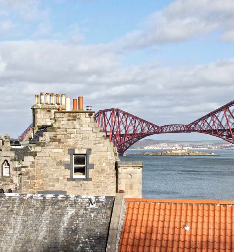
Queensferry
                                    Conservation Area
                                    Character Appraisal

Structure map

Conservation Area Boundary

Aerial image                 show

Built form                   show

Green belt                   show

Countryside policy area      show
(ENV5/ENV6)

Footpaths                    show

Open Space                   show

A.G.L.V.                     show

                                                          4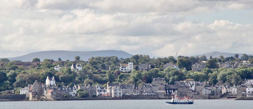
Queensferry
                                    Conservation Area
                                    Character Appraisal

Key Elements map

Conservation Area Boundary

Heritage Trees               show

Tree Preservation Order      show

Vistas                       show

Listed Buildings             show

Landmarks                    show

                                                          5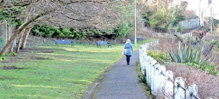
Summary information                                                                                                                        Queensferry
                                                                                                                                           Conservation Area
                                                                                                                                           Character Appraisal
Location and boundaries                                                                          Acknowledgements

Queensferry lies on the south shore of the Firth of Forth, around 13km west of the centre        This document has been produced
of Edinburgh. The nucleus of the conservation area is formed by the historic old town,           with the assistance of Queensferry and
and also includes Ravel Bank, the heavily wooded area of the Hawes, and an area of               District Community Council; Queensferry
land east of the Forth Bridge known as Gallondean which all contribute to the landscape          Ambition; Queensferry History Group and
setting of the town.                                                                             Queensferry Trust.

The conservation area is bounded on the north by the City of Edinburgh Council boundary
at the mean low water spring; on the west by the Forth Road Bridge; along the south by
the southern line of the disused railway, Hopetoun Road and Station Road (excluding 19-
33 Station Road and St. Margaret’s Primary School). The boundary then includes Dalmeny
Station and Rosshill Terrace before turning north and eastwards to a point on the shore
known as Long Rib east of the Forth Bridge.

The area falls within Almond ward and is covered by the Queensferry and District
Community Council. The population of Queensferry Conservation Area in 2011 was 937.

Dates of designation/amendments

The original Queensferry Conservation Area was designated on 13 October 1977. A
conservation area character appraisal was completed in 2001. The boundary was amended
in 2003 to include the villa area at Station Road and again in 2015 to include the group of
dwellings around Rosshill Terrace and Forth Terrace, associated with the construction of
the Forth Bridge.

Statement of significance

The architectural form and character of Queensferry is rich and varied with many fine
historic buildings dating from its origins as a medieval burgh and followingthrough several
periods including Georgian and Victorian, to the present day. The materials are traditional:
stone and harl, slate and pantiles, timber windows and doors. The roofscape is important
with its variations in form and features, such as crow-step gables, a variety of dormer styles
and chimneys with cans. The shoreline setting embraces the waterfront buildings and the
historic settlement is framed within the Victorian rail bridge and the 1960s road bridge.

                                                                                                                                                                 6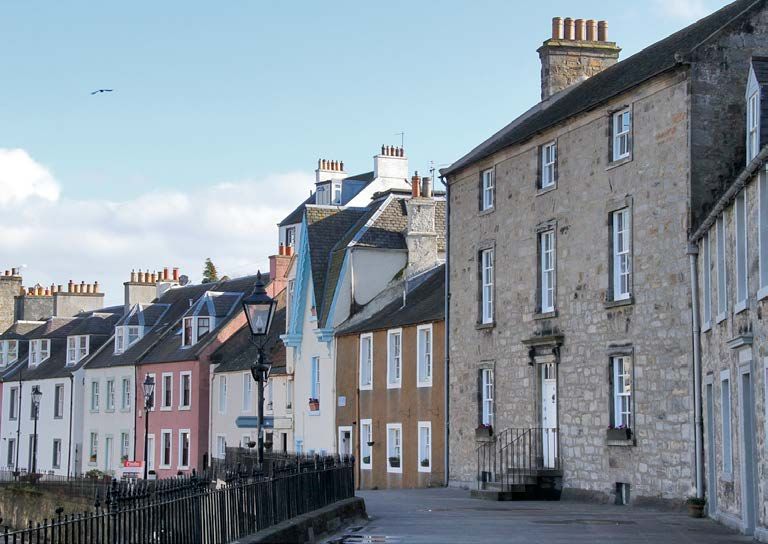
Conservation Area Character Appraisals                                                                                                             Queensferry
                                                                                                                                                   Conservation Area
                                                                                                                                                   Character Appraisal
Purpose of character appraisals - why do we need them?                                            How to use this document

Conservation area character appraisals are intended to help manage change. They provide           The analysis of Queensferry’s character and
an agreed basis of understanding of what makes an area special. This understanding                appearance focuses on the features which
informs and provides the context in which decisions can be made on proposals which may            make the area special and distinctive. This is
affect that character. An enhanced level of understanding, combined with appropriate              divided into two sections: Structure, which
management tools, ensures that change and development sustains and respects the                   describes and draws conclusions regarding
qualities and special characteristics of the area.                                                the overall organisation and macro-scale
                                                                                                  features of the area; and Key elements,
“When effectively managed, conservation areas can anchor thriving communities, sustain            which examines the smaller-scale features
 cultural heritage, generate wealth and prosperity and add to quality of life. To realise         and details which fit within the structure.
 this potential many of them need to continue to adapt and develop in response to the
 modern-day needs and aspirations of living and working communities. This means                   This document is not intended to give
 accommodating physical, social and economic change for the better.                               prescriptive instructions on what designs
                                                                                                  or styles will be acceptable in the area.
 Physical change in conservation areas does not necessarily need to replicate its                 Instead, it can be used to ensure that the
 surroundings. The challenge is to ensure that all new development respects, enhances             design of an alteration or addition is based
 and has a positive impact on the area. Physical and land use change in conservation              on an informed interpretation of context.
 areas should always be founded on a detailed understanding of the historic and urban             This context should be considered in
 design context.”                                                                                 conjunction with the relevant Local
From PAN 71, Conservation Area Management. www.scotland.gov.uk/Publications/2004/12/20450/49052   Development Plan policies and planning
                                                                                                  guidance. Management outlines the
                                                                                                  policy and legislation relevant to decision-
                                                                                                  making in the area. Issues specific to
                                                                                                  Queensferry are discussed in more detail
                                                                                                  and recommendations or opportunities
                                                                                                  identified.

                                                                                                                                                                         7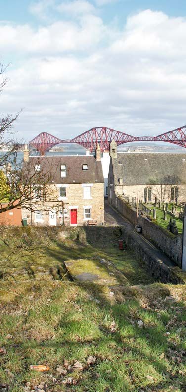
Historical origins and development                                                                                                            Queensferry
                                                                                                                                              Conservation Area
                                                                                                                                              Character Appraisal
A review of the historical development of Queensferry is important in order to understand
how the area has evolved in its present form and adopted its essential character.

Origins

The settlement of Queensferry probably has prehistoric origins and
owes its name and existence to the ferry passage across the Forth. Its
Gaelic name, cas chilis or cas chaolas means a fast-running strait. The
linear rock formations of the foreshore created natural landing points
and were later enhanced with piers and harbours. Queen Margaret,
wife of Malcolm III (Canmore), King of Scotland 1057-1093, endowed
the ferry crossing with boats, hostels and a right of free passage for
pilgrims travelling to St Andrews and Dunfermline Abbey. As a result
the crossing became associated with her royal title. This association
was strengthened by her own canonisation in 1250 and interment in
Dunfermline.

A Carmelite Friary was established close to the ferry landing, possibly
as early as 1330, and a church and monastery were built c.1450. At
the Reformation the Carmelite church building became the parish
church. This was abandoned when worship moved to the Vennel in
1635, and was then restored in 1889 to form the current Episcopal Church, known as the                                                                               Queensferry c.1832

Priory Church. It is the only medieval Carmelite church still in use in the British Isles.

Growth and trade

By the early 14th century, Queensferry had emerged as one of four Burghs owing allegiance    In the late 17th and 18th centuries the merchant fleet dwindled and the Burgh’s revenues
to Dunfermline Abbey and in 1576-7 was made into a ‘Burgh of Regality’, with certain         fell. Fishing and herring salting brought intermittent prosperity. 18th century turnpike
privileges of trading and customs. By the 1630s, Queensferry had become a flourishing        roads and fast stagecoach services from 1765 brought more trade to the ferries and this
seafaring town and in 1636 it became a Royal Burgh. Its leading burgesses were captains      resulted in demands for greater efficiency and better landings. During the latter half of
and shipmasters whose vessels were chartered, often by Edinburgh merchants, to carry         the 18th century, innovations in agricultural methods began to change the face of the
cargoes such as timber, salt, fish and wine to and from other parts of Britain, Europe and   rural landscape. The former open field system gave away to an enclosed field system
Scandinavia. Their prosperity is reflected in the number of 17th century buildings in the    and many woodlands, tree belts and estate landscapes around the area such as the
town and tombstones surviving in the Vennel kirkyard marked with ships, anchors and          Dalmeny and Dundas Estates date from this period.
navigational instruments.
                                                                                                                                                                                     8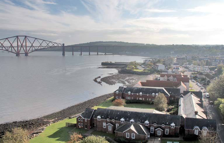
Queensferry
                                                                                              Conservation Area
                                                                                              Character Appraisal
The hamlet of New Halls to the east of the original settlement developed a pier and
inns catering for the crossing traffic. Its name evolved into Hawes and it was eventually
amalgamated into the Royal Burgh. It later became the base for construction yards and
workers’ accommodation for the Forth Bridge.

Crossing the Forth

An Act of Parliament in 1810 introduced a Board of Trustees to take control of the ferry
service. The Trustees were empowered to build new piers, buy new boats and generally
to improve the quality of service. It is recorded that during the year 1810-11, four large
sailing boats and four smaller yawls carried 1,515 carriages, 4252 carts, 18,057 cattle and
25,151 sheep, plus an average of 228 passengers per day. Sailing ships were gradually
replaced with steam vessels, however, rail ferry links via Granton and Leith had captured
much of Queensferry’s passenger trade by the mid 19th century. From 1878, a rail steamer
service linked Edinburgh and Dunfermline via the Trustees pier at Port Edgar. This seems
to have been used by local traffic and in 1890 the opening of the Forth Bridge made it
redundant.

Bridges

Another brief but significant boom came in the 1880s and 90s, with the construction of a
rail bridge by the Forth Bridge Railway Company. The workforce of 4,600 men and tourists
who came to see the work in progress brought trade and prosperity to the town. Workers
and engineers employed on the Forth Bridge were accomodated in purpose built housing
adjacent to the construction yard, at Rosshill Terrace, Forth Terrace and Forthview.

A report on possible routes for a road bridge was commissioned in 1929, but plans were
not approved until 1947, with the bridge opening in 1964. The arrival of the Road Bridge
brought an end to the car ferry passage at Queensferry. In 2011 construction began on a
third bridge, to the west of the Road Bridge and intended to relieve pressure on it, to be
named the Queensferry Crossing.

                                                                                                                    9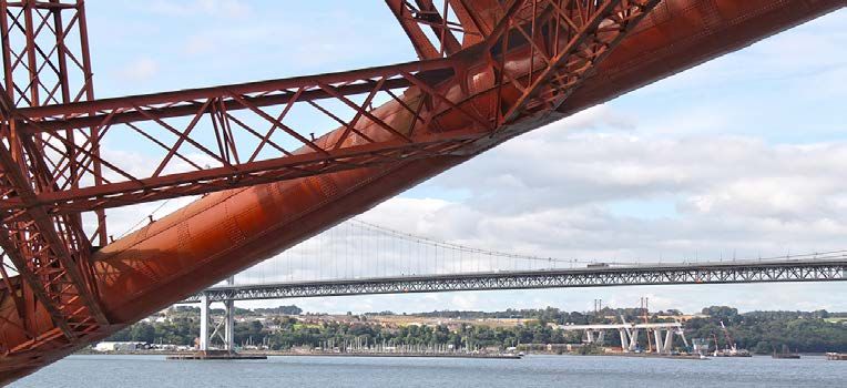
Queensferry
                                                                                                 Conservation Area
                                                                                                 Character Appraisal
Twentieth and twenty-first centuries

The naval base at Port Edgar, commissioned
in 1917, a distillery and the shale oil works
at Dalmeny benefited the town during the
20th century. Beyond the Burgh boundaries,
the surrounding landed estates provided a
steady source of trade and employment.
The 1975 Local Government (Scotland)
Act reorganised local authority boundaries
and Queensferry’s status as a Royal Burgh
was removed. Electronics, tourism and
the Hound Point tank farm and oil-loading
facility have been more recent sources of
employment for the area.

Summary

The medieval core of the Queensferry Conservation Area, with its rigg development
pattern, remains fairly intact. Alternating periods of modest prosperity and gentle decay
have left a richly varied townscape spanning five centuries. As a result, significant evidence
of each phase of the town’s history can still be read in the street pattern and buildings
surviving today.

                                                                                                                       10
Special Characteristics - Structure Queensferry
Conservation Area
Character Appraisal
Topography and Setting Views Development Pattern
Unique setting framed by the Forth, steep Open views down from the bridges onto Bridges form gateways at east and west
rising landscape, the Forth Bridge and the picturesque roofscape. ends of town.
Forth Road Bridge.
Grain and Density Streets Spaces
Sculptural, multi-level townscape form. Dense medieval core in a linear pattern Woodland and open space surround the
with riggs running north and south. core of the town to south and east.
11Special Characteristics - Structure Queensferry
Conservation Area
Character Appraisal
Topography
Queensferry is located at one of the narrowest points of the Forth estuary before it
broadens out eastwards to the sea, explaining its long history as the preferred crossing
point. The early part of the town is located on the shoreline, at the foot of a steeply
sloping bank and within a bay formed by two promontories, the Binks to the west and the
Craigs to the east. The historic core is therefore set back from the Forth within a natural
harbour and shelter. From Victorian times the town expanded at the top of the slope,
first along the main access roads and more recently along the north bank in a semicircle
around the old town.
Setting
The historic core of Queensferry is bounded by areas of woodland extending from the
Gallondean/Hawes Brae in the east, through Jock’s Hole and Back Braes to the former
railway lands between Hopetoun Road and Shore Road. These areas have a high amenity
and biodiversity value to the town and are included within the conservation area boundary.
The conservation area as a whole is bounded
by twentieth century residential areas to
the south and west and by the Forth Road
Bridge and Port Edgar to the west. To the
east and in its wider setting the protected
gardens and designed landscapes of the
Dalmeny, Dundas and Hopetoun estates
add to the area’s historic character. The
historic estate village of Dalmeny to the
south-east is designated as a separate
conservation area. To the north, most of
the coastline and islands of the Forth are
protected by national and international
designations covering important habitats,
species and geology.
12Special Characteristics - Structure Queensferry
Conservation Area
Character Appraisal
Views
Views of the Firth of Forth and Forth Bridge originating in Edinburgh city centre are defined
by the Council’s Skyline Study. Prominent development within and around Queensferry
would potentially impact in the fore- and middle ground of several key views. A similar
system of viewpoints and associated policies is being developed to support the protection
of the setting of the Forth Bridge.
In more local views, the sheltering topography of Queensferry means that its historic core
is only visible in longer views from its piers and on the water. Views down from the rail and
road bridges and from pathways at the upper levels of Back Braes and Ravel Bank provide
panoramas of the town’s picturesque roofscape against the backdrop of the Firth.
Within the conservation area, mid- and short-range views are important along the gently
curving High Street and out towards the Forth, the Fife coast and the bridges through
gaps in the northern building line and from the Hawes Promenade. Glimpse views along
pends and narrow lanes, of the harbours and Forth to the north and gardens to the south,
add to the picturesque qualities of the townscape.
13Special Characteristics - Structure Queensferry
Conservation Area
Character Appraisal
Development pattern
Topography dictated the earliest development of the town within a restricted strip
between the harbour and the southern escarpment. Development along the High Street
follows a linear pattern and reflects the curve of the bay. The gentle curve in the street is
emphasised especially on its south side by raised pavements. The building line forms an
unbroken terrace wall, but widens and narrows in places such as the Black Castle. To the
south, the narrow rigg ownership pattern radiates back from the High Street up the banks
towards the former railway line.
On the north or seaward side, development largely fronts the High Street, turning its
back to the harbour. There are a few survivals of L-shaped buildings with gables facing
the coastline, typical of Scottish fishing villages. The building line is interrupted by wider
breaks giving an awareness of the lower plane of the beach. These different levels following
the coastline give the High Street a strong sculptural character. This multi-layered effect
is continued with the spectacular separation in height between the rail or road deck levels
of the bridges and the streets below. This gives a sense of calm isolation to the town,
protected from the high-speed traffic flying past above.
The three road approaches on the landward side of the conservation area follow the
historic routes connecting the town with Linlithgow, Kirkliston and Edinburgh. The road
bridge at the west and the rail bridge in the east act as gateways and provide a sense of
arrival. Seals Craig creates a kink in the line of the road and forms an inner gateway and
shelter to the High Street. The parish church and manse, and St. Margaret’s Church on
either side of the top of the Loan (Kirkliston Road) also function as a gateway.
The Hawes and the developments along Station Road are notable for their physical
separation and contrasting character from the High Street. Their separation from the
historic core allows the woodland to almost reach the water’s edge, provides amenity and
acts as a visual break between these areas of different character.
The former Forth Bridge Railway Company housing towards the east end of Station Road
has a distinct character, closely defined by the two adjacent rail routes and Dalmeny Station.
Victorian villa development at the west end of Station Road created a generous suburban
layout with wide streets and large plots. Station Road forms an interesting approach and
edge to the conservation area, with contrasts between modern development, historic
houses and railway infrastructure, large expanses of open space and mature treescapes.
14Special Characteristics - Structure Queensferry
Conservation Area
Character Appraisal
Grain and density
Density of development within the historic core is high, consistent
with its constricted site and the relatively crowded character of
medieval urban development. The solid building line conceals the
open spaces of rear plots from the High Street except in glimpse
views. Some of these riggs are divided into small garden courts, while
others still retain early development, creating intimate groupings
of small-scale spaces, buildings and narrow access ways. This is
particularly evident on those plots that back on to Hawthornbank.
The Hawes is of a much lower density, with large Edwardian villas
facing the spectacular view. Many of these have been converted
to hotels, cafés and gift shops catering for visitors. Kirkliston Road,
Station Road and Stewart Terrace have a strongly coherent pattern
of well-spaced, detached villas set in generous, rectangular plots.
These villa plots stand out from both the narrower but often longer
plots of the historic core and from the smaller and denser pattern of
later 20th century suburban development. The Forth Bridge Railway
Company housing around Rosshill Terrace consists of three terraces
of modest cottages with long strip gardens, plus a pair of larger villas.
Streets
The sinuous curve of the High Street is reflected by its street
surfacing and the alignment of pavements, terraces, railings and
building frontages. Vertical circulation, formed by steps, closes and
wynds, connects the various levels of beach, High Street, terraces,
gardens and upper brae beyond. Station Road and the pedestrian
links leading from it are important in connecting Dalmeny Station
both with the High Street and the wider suburbs to the south.
20th century traffic engineering altered the townscape at the west
end of the High Street, isolating Hopetoun Road from the main town
centre and creating an artificial gateway at the Bell Stane.
15Special Characteristics - Structure Queensferry
Conservation Area
Character Appraisal
Spaces
Queensferry has an abundance of open space with a variety of roles and characteristics.
Private open space of gardens and courtyards play a significant role, softening the density
and hard frontages of the historic core and providing visual relief and glimpse views.
Urban, public open space is less prominent but there are examples of small squares and
formal gardens such as the garden around the Provost’s drinking fountain next to Rosebery
Hall, and the square opening onto the beach access steps between Mid and West Terrace.
The Hawes esplanade is the most significant example of this type of space. Its value as
amenity space is eroded by the visual dominance of parking alongside it. A small public
park and bowling green are located within the conservation area, just off Station Road, as
well as a playspace to the south of Forth Terrace. The beaches, harbours and piers provide
distinctive spaces within the town and spectacular, panoramic viewpoints.
Woodland and landscape amenity space are critical to the character of Queensferry,
enclosing the historic core and providing visual breaks between contrasting areas.
16Special Characteristics - Key elements Queensferry
Conservation Area
Character Appraisal
Scale Building Types and Styles Landmarks
Overall unity created by regular scale and Buildings dating from 17th to mid-20th The bridges are the dominant landmarks
proportions. century reflecting gradual evolution. in long range views; local landmarks are
more evident from within the High Street.
Materials and Details Trees and Gardens Streetscape and Activity
Restricted palette of materials given Gardens preserve historic rigg features. Good quality historic and more recent
variety through differing treatments and streetscape and boundary features.
architectural styles.
17Special Characteristics - Key elements Queensferry
Conservation Area
Character Appraisal
Scale
Buildings are mainly 2 to 3½ storeys in height. Narrow frontages set up a rhythm along the
street, and vertical planes are emphasised by the subtle variation of heights which expose
parts of gables. The continuity of frontages and narrow proportions of the street create a
strong sense of enclosure. The buildings are also relatively shallow in depth. This results
in regular contrasts of enclosure to openness, revealed in views down narrow wynds and
low close entrances.
18Special Characteristics - Key elements Queensferry
Conservation Area
Character Appraisal
Building types and styles
The earliest surviving secular buildings are L-plan at the corner of the High Street and
the merchants’ houses of the 17th century, The Loan. This is an interesting example
such as Plewlands House and the Black of architecture of its date, and relates to
Castle. These are characterised by an the contemporary regeneration of historic
L-plan form of main range and projecting fishing communities in Fife such as Dysart
jamb, steeply-pitched roofs with straight and Burntisland. However its siting and mass
or crowstepped skews, small windows and, disrupt the strong historic pattern around it.
occasionally, surviving forestairs. Elements
The Hawes and Station Road villa areas share
of buildings of this period are likely to survive
some characteristics, being large dwellings
elsewhere, disguised by later alterations and
set back from the road frontage in generous
additions.
grounds. Apart from the Hawes Inn these
Georgian and early Victorian buildings buildings date from the Victorian and
predominate within the historic core and Edwardian expansions of the town. Station
provide its underlying coherence through Road villas are relatively uniform in layout,
the largely continuous building line, the scale and character, generally having formal,
uniformity of building type, similar heights, symmetrical front elevations, piended roofs,
narrow frontages, solid to void relationships large plate-glass sash and case windows and
and window sizes. It is difficult to distinguish tall stacks. Tudor-inspired multi-gable forms
which buildings are flatted, except possibly also feature. The Hawes villas are more varied
over shops, and those which are town with no predominant style, although all have
houses. been heavily altered and extended reflecting
their change from original domestic use to
Later insertions into the High Street largely
hotels, public houses and restaurants.
conform to the earlier pattern of scale,
building line and materials but add variety The Forth Bridge development around
of style and decoration. These include the Rosshill Terrace consists of three rows of
Baronial Clydesdale Bank at 35 High Street, cottages and a pair of villas. Forth Terrace
and the Rosebery Memorial Hall built in the is unusual in that it has no conventional front
Scots Renaissance style in 1894. The Council elevation. This may indicate that amenities
offices and museum at 53 High Street form like kitchens and bathrooms were added
an eye-catching, white-harled block with after the initial purpose was over with
some Arts and Crafts features. The municipal completion of the bridge, as the workforce
housing at Hill Court, built in 1964, forms an had a communal dining hall.
19Special Characteristics - Key elements Queensferry
Conservation Area
Character Appraisal
Landmarks
The Forth Bridge and Forth Road Bridge are the
outstanding landmarks, dominating the town and
the wider area with their sheer scale and presence.
However, the bridges are often hidden from view
within the enclosure of the High Street, allowing
local landmarks to become more evident. These
include the Tolbooth steeple, the Seals Craig
Hotel and the spire of the parish church, viewed
on the skyline from the north.
Materials and details
A significant level of uniformity is achieved from The historic buildings in the
the use of local building materials, despite the Rosshill Terrace area contrast
considerable range of building styles. The with most of the conservation
predominant materials form a restricted palette area, constructed in a palette
of rubble and dressed sandstone, render and of brick with shallow slate roofs,
slate roofing. The variety of treatment provides tripartite windows with narrow
interest with decorative tooling and carved margin lights, arched detailing
stonework, often reflecting maritime connections, to ground floor openings and
pediments, doorframes and marriage lintels, paired, recessed porches. Forth
dressed or rendered margin bands, chamfered Terrace has undergone more
corners, gable windows and crowsteps, cast iron significant change but retains its
signs and railings. unusual mansard roof form with
raised party walls. Although
The later villas are built in a more sombre and
some detail and materials have
formal dressed stone and with more intricate
been eroded, such as by painting
and decorative detailing of entrances, bay
or replacement of roof materials,
windows, dormers and front gablets projecting
the overall impression remains of
out on exposed decorative trusses. There are also
an intact grouping from a single
examples in the Arts and Crafts style with white
historic phase of development,
render, painted timberwork and complex roof
with regular massing and rhythm.
forms.
20Special Characteristics - Key elements Queensferry
Conservation Area
Character Appraisal
Trees and gardens
Gardens and landscapes are a dominant
feature of the conservation area, both
private gardens and publicly-accessible
green spaces. The garden ground relating
to the High Street preserves the historic
rigg pattern of the medieval burgh. The
managed, domestic scale and character of
these spaces, along with the profusion of
ornamental species, provide a rich green
environment.
The large plots of the villa areas have a
more open character with formal garden
landscaping with prominent individual
mature trees and hedges. The former
gardens of large houses in Station Road,
such as Rosshill and Ashburnham House,
have been developed for housing but
preserve some of their trees and boundary
features.
These areas contrast with the informal,
semi-wild planting and sinuous pathways
of the Ferry Glen and Back Braes. The
profusion of trees at various stages of
maturity, along with the rich biodiversity
they support, are important for their extent
and cumulative effect rather than any single
specimen or specific area.
21Special Characteristics - Key elements Queensferry
Conservation Area
Character Appraisal
Streetscape Activity
The raised terraces of the High Street, Queensferry is the largest settlement in Visitors are a major factor in the town’s activity,
providing pedestrian access across the rural west Edinburgh with four primary drawn by views of the bridges and access to
roofs of ground-floor shops to terraced schools, a high school, library, churches, the water. The Hawes Pier is used by boat
entrances above, are one of the outstanding community centres, a leisure centre, trippers to the islands in the Forth and the
streetscape features of Queensferry. museum, police station, health and welfare harbour is used for private boat moorings.
Natural stone treads, paving, setts and services. The High Street retains a variety The Firth of Forth is one of Scotland’s
cast iron railings survive along their length, of shops, bars and restaurants although busiest commercial shipping channels and
although in poor condition in places. most residents’ convenience shopping is performs a key role in Scotland’s economy
Examples of modern ironwork along the done in the larger supermarkets outwith given its link as major export location for
High Street have also added to the quality the historic core of the town. Scotland’s oil and gas. It is also a destination
of detail in this area. for Cruise liners which berth in the Firth and
This sense of activity along the High Street
ferry passengers to Hawes Pier. In addition,
The majority of the traditional, natural stone contrasts with the peace and quiet of the
a range of watersport activities take place
finishes of the High Street are the result of villa area on the ridge above. The high
within it. Dalmeny Tank Farm is situated in
streetscape enhancement works of the ground behind the High Street to the
the Firth of Forth and linked by a pipeline
1990s. However, the general design and south is used for informal recreation such
to the tanker terminal at Hound Point. The
material palette reflect the historic character as dog walking, walking and running. The
works depot and yards adjacent to Dalmeny
of the street and respond to its distinctive Gallondean to the west has a coastal path
Station remain the main hub of activity for
features. Footway and carriageway surfaces linking with Cramond.
maintenance of the Forth Bridge.
elsewhere are generally in modern finishes.
In the Hawes and villa areas, property
boundaries are generally formed by rubble
walls – dwarf walls with hedges and gate
piers in the villa area, and more substantial,
high walls at the Hawes and Edinburgh
Road. Stubs of traditional railings removed
for the war effort occasionally remain.
Relatively low, timber picket-style fences
predominate in the Rosshill Terrace area.
The Hawes waterfront is bounded by 1930s
esplanade railings, adding to its distinctive,
seaside air.
22Management - Legislation, policies and guidance Queensferry
Conservation Area
Character Appraisal
Conservation areas a material consideration when considering • Designed Landscapes E14
applications for development within
The Planning (Listed Buildings and • Trees and Woodland E15, E16
conservation areas.
Conservation Areas) (Scotland) Act 1997
• Nature conservation and biodiversity
states that conservation areas “are areas
Listed buildings E17-E22
of special architectural or historic interest,
the character or appearance of which it is A significant proportion of buildings • Archaeology E29-E31
desirable to preserve or enhance”. Local within Queensferry are listed for their
authorities have a statutory duty to identify • Historic buildings E32-E34
special architectural or historic interest
and designate such areas. and are protected under the Planning • Conservation areas E35-E40
(Listed Buildings and Conservation Areas)
Special attention must be paid to
(Scotland) Act 1997. Listed building • Design of new development E41-E44
the character and appearance of the
consent is required for the demolition of a
conservation area when planning controls • Open space E51-E52
listed building, or its alteration or extension
are being exercised. Conservation area
in any manner which would affect its special • Economic development and tourism
status brings a number of special controls:
character. ED2, ED11
• The demolition of unlisted buildings
requires conservation area consent. • Transport TRA5-TRA7
National policy
• Permitted development rights, which • Retailing R1-R3, R5
The Scottish Historic Environment Policy
allow improvements or alterations to the (SHEP) is the strategic statement of national The proposed City of Edinburgh Local
external appearance of dwellinghouses policy relating to the historic environment. Development Plan (LDP) contains
and flatted dwellings, are removed. broadly similar policies and is a material
• Works to trees are controlled (see Trees The development plan consideration in current planning decisions.
for more detail).
The Rural West Edinburgh Local Plan
Planning guidance
The demolition of unlisted buildings (RWELP) sets out policies and proposals
considered to make a positive contribution for the development and use of land in and More detailed, subject-specific guidance is
to the area is only permitted in exceptional around Queensferry. The policies in the set out in Planning Guidance documents.
circumstances, and where the proposals Plan are used to determine applications Those particularly relevant to Queensferry
meet certain criteria relating to condition, for development. In broad summary, the Conservation Area are:
conservation deficit, adequacy of efforts key policy areas affecting Queensferry
Conservation Area are: • Guidance for Householders
to retain the building and the relative
public benefit of replacement proposals. • Guidance for Businesses
• The Coastline E12, E13
Conservation area character appraisals are
23Management - Legislation, policies and guidance Queensferry
Conservation Area
Character Appraisal
• Listed Buildings and Conservation Areas of relatively minor developments in at a point 1.5m above ground level. The
conservation areas which can cumulatively planning authority must be given six weeks
• Developer contributions and affordable
lead to the erosion of character and notice of the intention to uproot, fell or lop
housing
appearance. Queensferry Conservation trees. Failure to give notice will render the
• Edinburgh Design guidance Area has Article 4 Directions covering the person liable to the same penalties as for
following classes of development: contravention of a Tree Preservation Order
• Communications Infrastructure (TPO).
7 The erection, construction,
• Street Design Guidance – in draft, maintenance, improvement or Tree Preservation Orders are made under
published May 2014 alteration of a gate, fence, wall or other planning legislation to protect individual
means of enclosure and groups of trees considered important
In addition, a number of statutory tools
for amenity or because of their cultural or
are available to assist development 18 The carrying out on agricultural land
historic interest. When assessing amenity,
management within the conservation area: in an agricultural unit of works for the
the importance of trees as wildlife habitats
erection, extension or alteration of a
will be taken into consideration. There is
GPDO and Article 4 Directions building; the formation, alteration or
a strong presumption against any form
maintenance of private ways; or any
The Town and Country Planning (General of development or change of use of land
excavation or engineering operations,
Permitted Development) (Scotland) which is likely to damage or prejudice
for the purposes of agriculture.
Order 1992, amended 2012, (abbreviated the future long term existence of trees
to GPDO), restricts the types of 38 Development by statutory undertakers covered by a TPO. The removal of trees for
development which can be carried out in for the purpose of water undertakings arboricultural reasons will not imply that the
a conservation area without the need for space created by their removal can be used
39 Development by a public gas supplier for development. One Tree Preservation
planning permission. These include most
alterations to the external appearance of Order applies within the conservation area,
40 Development by an electricity statutory
dwellinghouses and flats. Development off Station Road between Ashburnham
undertaker
is not precluded, but such alterations will Gardens and St Mary’s RC Primary School.
require planning permission and special
Trees (elements key) Vegetation management to protect and
attention will be paid to the potential effect restore important viewpoints of the Forth
of proposals. Trees within conservation areas are Bridge is listed as an action in the Forth
covered by the Town and Country Planning Bridge Management Plan. Trees in the city
Under Article 4 of the GPDO the planning
(Scotland) Act 1997 as amended by the contains a set of policies with an action
authority can seek the approval of the
Planning (etc) Act 2006. This Act applies plan used to guide the management of the
Scottish Ministers for Directions that restrict
to the uprooting, felling or lopping of a Council’s trees and woodlands.
development rights further. The Directions
tree having a diameter exceeding 75mm
effectively control the proliferation
24Management - Legislation, policies and guidance Queensferry
Conservation Area
Character Appraisal
Landscape and Biodiversity (structure Landscapes surround Queensferry associated with the construction of the rail
map) Conservation Area: Dalmeny, Dundas and road bridges. Marine archaeology is
Castle and Hopetoun House. The wider also present along the foreshore.
The Council has an obligation to take
coastal landscape including the Cramond
account of the impact of development Remains of these structures may survive
coast, Lauriston policies, Dalmeny policies
on species protected by legislation and below existing development, although
and Queensferry waterfront, forms the
international commitments. The Nature the extent of their survival is currently
Southern Forth Coast Special Landscape
Conservation (Scotland) Act 2004 places unknown due to the lack of modern
Area (SLA).
a duty on all public bodies to further the archaeological investigations in the area.
conservation of biodiversity as far as is Depending on the scale and impact
Archaeology
consistent with their functions. The rich of any development proposal, the City
wooded landscapes, open spaces and Queensferry has been continuously of Edinburgh Council Archaeology
foreshore of the conservation area give it inhabited for in excess of 1000 years. Its Service (CECAS) may recommend a pre-
a high amenity and biodiversity value. The current townscape contains surviving determination evaluation in order to
conservation area boundary overlaps with elements from at least 700 years and there assess the presence and significance of
the local biodiversity sites of Hopetoun may be evidence of earlier occupation any surviving archaeological deposits and
Road, Dalmeny Estate and the Newbridge surviving below existing structures or to determine the scope of any required
to South Queensferry Walkway. The landscapes. Canmore notes various mitigation including preservation. Similarly
Gallondean forms part of the Leuchold discoveries of bones, funeral urns, for works affecting standing structures
Wood ancient woodland. etc in Queensferry and its immediate of historic significance, a programme of
neighbourhood. Several cists, with archaeological building assessment and
The Firth of Forth is protected by a range of
skeletons and other remains of interment recording may be recommended.
local, national and international landscape
were reported found during railway
and environmental designations including There are no scheduled monuments
construction from the 1850s and onwards.
a Site of Special Scientific Interest (SSSI), located within Queensferry Conservation
the Firth of Forth Special Protection Area The area may contain the remains of a wide Area.
(SPA) and Ramsar site. In accordance with range of historic sites and uses including
the Habitat Regulation any development the Carmelite friary complex, medieval (and
affecting the Firth of Forth SPA may be later) ferry landings and facilities for pilgrims
subject to a Habitats Regulations Appraisal and travellers, maritime industries, activities
(HRA) to determine that there will be no associated with the rigg system, post-
adverse effect on the integrity of the site. medieval land-based industries such as
brewing and distilling, shale oil extraction,
Three historic landscapes included in the
quarry sites, railway infrastructure and sites
national Inventory of Gardens and Designed
25Management - Pressures and sensitivities Queensferry
Conservation Area
Character Appraisal
In contrast with many conservation Recommendation: Historic surfacing
areas, the main pressures in Queensferry materials, ironwork and detailing should
Conservation Area are not principally a always be retained and repaired where
result of private development but relate they survive. Lost features should be
to infrastructure and the public realm. reinstated where there is evidence.
Their central role in the character and Training and education in specification
appearance of the conservation area makes and maintenance of appropriate materials
all of the following issues key opportunities would assist in protecting these features in
for enhancement. the longer term.
Many of these issues are longstanding
Development of riggs and gardens
in origin, and solutions must involve
community engagement and creative The secluded green spaces of the historic
collaboration between multiple agencies. riggs are a key amenity for the conservation
Community-led efforts to resolve some area. Development of gardens and
of these are already underway. The backland spaces has the potential to impact
recommendations made below assume the significantly on the area’s special character,
historic environment is used as the starting landscape quality and biodiversity.
point for creative decisions. Archaeological remains may also be
impacted by development.
Historic streetscapes
Recommendation: The character, density
Queensferry has a rich legacy of historic and pattern of the context must be
ironwork, complemented by high quality respected in any development proposal.
modern examples. The raised terraces Standing remains should be recorded
unique to Queensferry are deteriorating and understood before proposals are
in places, risking the loss of quality and developed. Where development is
special character of the High Street. acceptable in principle it should be
The vennels leading north and south deferential in scale, appropriate in its use
from the High Street are also at risk from and enhance the distinctive character of
privatisation of access, blocking of glimpse the space.
views and pedestrian routes, and erosion of
traditional surfacing materials.
26Management - Pressures and sensitivities Queensferry
Conservation Area
Character Appraisal
Pedestrian connectivity Traffic management and parking waterfront facades is also of key importance
in protecting the character and appearance
As a result of topography, maintenance Existing pressures from visitors, residents
of the conservation area.
and some 20th century traffic management and workers, along with projected increases
decisions, disparate areas of the town in visitors as a result of enhanced interest Recommendation: Proposals to develop
centre have become isolated from each in the Bridges, create serious pressures on and regenerate waterfront features
other. Access difficulties particularly affect existing traffic routes and parking areas. should protect and repair historic fabric,
vulnerable age groups, those with mobility and reinstate lost features where there is
Recommendation: The historic character
problems, and visitors with no prior evidence for them. The historic character
of the town is a key amenity for all users
knowledge and in need of orientation. This of these areas should be emphasised in
of the town. Potential solutions for roads
reduces the attractiveness, vibrancy and proposals for change of use or development.
and parking must therefore respect the
active economic use of the historic town The outstanding landscape and natural
character of the conservation area. A
centre, which in the long term threatens its environment significance of these spaces
variety of solutions are likely to be
economic health and the protection of its will also be a critical consideration.
necessary, including investigating new,
character.
peripheral parking areas, incorporating
Recommendation: Historic routes and environmental enhancements into new
connections should provide the basis for or redesigned central parking areas and
enhancements to connectivity. Historic removing pressure from vehicular traffic
features can help to re-join fractured areas by investigating alternative, sustainable
of the town and provide an appropriate transport methods where possible.
context for new development. Sensitive
traffic engineering and wayfinding should Shoreline, piers and harbours
redress the balance between vehicular
and pedestrian users, in conjunction with The approach to Queensferry from the
other infrastructure improvements such as Forth was historically of central importance
parking. but this aspect of its character has been
diminished since the loss of the ferries and
fishing trade. Greater appreciation of the
town from the water, piers and shoreline
could create additional viewpoints as
draws for visitors and generate interest in
fuller, more productive, income-generating
use of these facilities. The treatment of
27Management - Management - Queensferry
Opportunities for development Opportunities for planning action Conservation Area
Character Appraisal
Small-scale development opportunities for The Forth Bridge as a potential World meeting of the UNESCO World Heritage
infill or replacement may arise within the Heritage Site Committee in the summer of 2015.
historic core, and will be considered under
World Heritage Sites are places of Statutory designations surrounding the
the policies and guidance listed at 5.1.
outstanding universal value for their cultural, bridge, particularly those covering the
Development on a significant scale is natural or combined qualities inscribed by bridgehead communities of North and
unlikely to take place within the conservation the United Nations Educational, Scientific South Queensferry, will be the principal
area although a number of sites on its and Cultural Organisation (UNESCO) under means of protecting the outstanding
peripheries may be affected, such as Port the World Heritage Convention. There are universal value of the Bridge and its setting.
Edgar, the Corus site adjacent to the Forth currently five World Heritage Sites located
This document aims to demonstrate the
Bridges Contact and Information Centre in Scotland.
safeguards given by the planning authority
and at the wider edges of the settlement,
The UK Tentative List of potential world to the setting of the bridge. It also offers a
particularly when the Queensferry
heritage sites was reviewed in 2010/11. means for communicating local community
Crossing comes into use. In most
The Forth Bridge was included in the support and interest in its historic
instances development is unlikely to have
shortlist of eleven candidate sites, and environment.
a significant visual impact on the setting
was subsequently chosen as the first site
of the conservation area or the Bridges
from that list to be submitted to UNESCO
owing to the topography, domestic scale
for consideration. An intensive period
and intervening development. However,
of research and consultation resulted in
proposals will be monitored to ensure the
a nomination dossier being submitted in
sensitivities of these features are taken into
January 2014.
account. View protection (discussed below)
also has a role to play in this issue. The nomination document makes the
justification for the site’s inscription,
A development brief has been produced
based on the criteria set out by UNESCO,
for Port Edgar.
includes a description of the site, details on
the existing protection and management
of the site, its state of conservation,
and information on known threats and
potential opportunities. This will undergo
a demanding 18-month process of scrutiny
and evaluation by UNESCO and its advisory
body ICOMOS (International Council
on Monuments and Sites). The earliest
possible date for a decision will be at the
28Management - Queensferry
Opportunities for planning action Conservation Area
Character Appraisal
Conservation area boundaries However, its character contrasts with that It is recommended that the merits of
of the main town of Queensferry and expanding the boundary to include the
The boundaries have been re-examined
it is not considered appropriate as an Rosshill Terrace area are investigated
through the appraisal process. Suggestions
extension of Queensferry Conservation further, including consultation with owners,
were considered for various changes,
Area. The majority of its significant the wider community and other interested
both to include wider areas (such as Port
structures are already protected by listing groups.
Edgar, the wider suburbs of the town or
and the planning brief above sets out the
the historic Bridge construction yard and
key considerations for its potential future
workers cottages at Forth Terrace) and to
development. The merits of designating
reduce its size (for example by removing
this area as a separate conservation area
modern development along Station Road).
will be considered further as plans for its
The current extent of the boundary, development evolve.
adopted in 2003, was carefully considered
The area of the historic Forth Bridge
in order to encompass the most distinctive
construction yard and workers’ cottages
architectural and historic features of the
at Forth Terrace and Rosshill Terrace, east
settlement, and to include a suitable belt
of Dalmeny station, is also considered to
of the wooded landscape surrounding
potentially meet the criteria for designation.
the core of the town. This is considered
The three terraces of cottages to the south
to provide a zone of suitable breadth and
of Station Road and the area including
quality to protect both the historic town View protection framework
Forthview West and East to the north are
core and the immediate setting of the
surviving evidence of the construction Historic Scotland has carried out a study
Bridges. Reductions in its extent are not
and development of the Forth Bridge of key viewpoints and viewsheds around
considered appropriate.
and its impact on the development of the the Forth Bridge. This will help assess the
Most of the suggested areas of expansion town. They form an interesting grouping impact of development proposals and
are not considered to meet the criteria of of buildings and gardens, related to the inform its nomination as a World Heritage
being of special architectural or historic existing railway line, the station and the Site. The key viewpoints identified in
merit. Port Edgar however is considered to disused line to the west now used as a the nomination document are a material
be of interest in its own right. Its national footpath and cycleway. They are not planning consideration. If the nomination is
significance as a naval base, and the protected by listing and may be at risk successful, the merits of adopting a formal
evidence for that history remaining in situ from uncontrolled demolition or erosion view protection system, complementing
in the form of historic buildings, spaces, of character. However some degree that already in place for the neighbouring
street layout, piers etc. potentially meet of unsympathetic alteration and infill Old and New Towns of Edinburgh World
the criteria for selection and would merit development has already occurred. Heritage Site, will be considered.
further research.
29Management - Queensferry
Opportunities for enhancement Conservation Area
Character Appraisal
The pressures and sensitivities listed
on page 26 are considered the key
opportunities for enhancement of
the conservation area. Solutions, or
improvements, to these issues would make
a significant difference to the quality and
vitality of the historic environment in the
town. Quality of life would be enhanced
for residents and other users, and the
visitor experience would be improved.
30Sources Queensferry
Conservation Area
Character Appraisal
Print
Dennison, E. Patricia and Coleman, Russell, Historic North Queensferry and Peninsula – the Scottish Burgh
Survey, Tuckwell Press, 2000
Forth Bridges Forum, The Forth Bridge Management Plan 2014-2019
Harris, Stuart, The Place Names of Edinburgh, Steve Savage, 2002
Historic Scotland, The Forth Bridge - Nomination for Inclusion in the World Heritage List: Nomination Document.
Edinburgh, Historic Scotland for the Forth Bridges Forum, 2014
McWilliam, Colin and Wilson, Christopher The Buildings of Scotland: Lothian except Edinburgh, Penguin, 1978
Mullay, S., The Illustrated History of Edinburgh’s Suburbs, Breedon, 2002
Web
Canmore (RCAHMS online database)
Edinburgh Skyline Study
Fife Council, North Queensferry
Conservation Area Appraisal and
Conservation Area Management Plan
Forth Bridges
James, Heather F., GUARD Coastal
Assessment Survey, The Firth of Forth
from Dunbar to the Coast of Fife, Historic
Scotland 1996
Museum of the Scottish Shale Oil Industry
PAN 71, Conservation Area Management
Queensferry History Group
Queensferry and District Community Council
31Queensferry
Conservation Area
Character Appraisal
Queensferry
Conservation Area
Character Appraisal
For further information please contact:
built.heritage@edinburgh.gov.uk
0131 529 4238
32You can also read