Îles de la Paix National Wildlife Area Management Plan
←
→
Page content transcription
If your browser does not render page correctly, please read the page content below
Îles de la Paix
National Wildlife Area
Management Plan

               Îles de la Paix National Wildlife Are Management Plan   i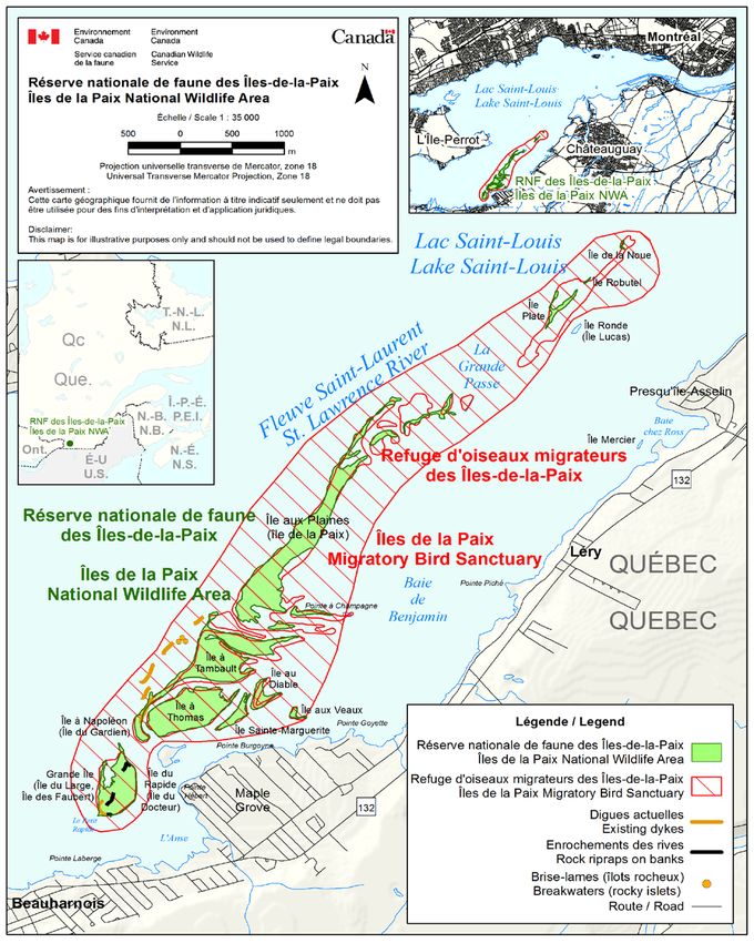
Acknowledgements:
This management plan was developed by Isabelle Ringuet and Benoît Roberge of the Canadian Wildlife
Service of Environment Canada. Thanks are extended to Canadian Wildlife Service employees who were
involved in the development or review of the document, including Luc Bélanger, Marielou Verge, Josée
Deguise, Olaf Jensen, David Boivin, Alain Baril, Véronique Lalande, Ken Brock, Renée Langevin,
Matthieu Allard, Martine Benoît, Benoît Jobin, Christine Lepage, Cédric Paitre, Diane Dauphin, Gilles
Falardeau, Sylvain Giguère, Stéphanie Gagnon, Chantal Lepire, Francine Rousseau and Josée Tardif, as
well as François Daigle of the Wildlife Enforcement Directorate. Acknowledgement is also due to
Christiane Foley for her contribution to this work. The Canadian Wildlife Service also wishes to thank Eva
Johnson and Dennis Diabo from the Aboriginal Mohawk community of Kahnawake who agreed to
comment this document.

Copies of this plan are available at the following addresses:

Environment Canada
Inquiry Centre
10 Wellington Street, 23rd Floor
Gatineau QC K1A 0H3
Toll free number: 1-800-668-6767 (in Canada only)
Email: enviroinfo@ec.gc.ca

Environment Canada – Canadian Wildlife Service
Quebec Region
801-1550 D’Estimauville Avenue
Québec QC G1J 0C3

Environment Canada Protected Areas website at: www.ec.gc.ca/ap-pa

ISBN: 978-1-100-21931-8
Cat. No.: CW66-328/2014E-PDF

How to cite this document:
Environment Canada. 2014. Îles de la Paix National Wildlife Area Management Plan.
Environment Canada, Canadian Wildlife Service, Quebec, 38 p.

Unless otherwise specified, you may not reproduce materials in this publication, in whole or in part, for the
purposes of commercial redistribution without prior written permission from Environment Canada’s
copyright administrator. To obtain permission to reproduce Government of Canada materials for
commercial purposes, apply for Crown Copyright Clearance by contacting:

Environment Canada
Inquiry Centre
10 Wellington Street, 23rd Floor
Gatineau QC K1A 0H3
Telephone: 819-997-2800
Toll free number: 1-800-668-6767 (in Canada only)
Fax: 819-994-1412
TTY: 819-994-0736
Email: enviroinfo@ec.gc.ca

© Her Majesty the Queen in Right of Canada, represented by the Minister of the Environment, 2014

Aussi disponible en français
About Environment Canada Protected Areas and
Management Plans

What are Environment Canada Protected Areas?
       Environment Canada establishes marine and terrestrial National Wildlife Areas for the
purposes of conservation, research and interpretation. National Wildlife Areas are established to
protect migratory birds, species at risk, and other wildlife and their habitats. National Wildlife
Areas are established under the authority of the Canada Wildlife Act and are, first and foremost,
places for wildlife. Migratory Bird Sanctuaries are established under the authority of the
Migratory Birds Convention Act, 1994 and provide a refuge for migratory birds in marine and
terrestrial environments.

What is the Size of the Environment Canada Protected Areas Network?
       The current Protected Areas Network consists of 54 National Wildlife Areas and
92 Migratory Bird Sanctuaries comprising more than 12 million hectares across Canada.

What is a Management Plan?
       A management plan provides the framework in which management decisions are made.
They are intended to be used by Environment Canada staff to guide decision making, notably
with respect to permitting. Management is undertaken in order to maintain the ecological
integrity of the protected area and to maintain the attributes for which the protected area was
established. Environment Canada prepares a management plan for each protected area in
consultation with First Nations, the public and other stakeholders.
       A management plan specifies activities that are allowed and identifies other activities that
may be undertaken under the authority of a permit. It may also describe the necessary
improvements needed in the habitat, and specify where and when these improvements should
be made. A management plan identifies Aboriginal rights and allowable practices specified
under land claims agreements. Further, measures carried out for the conservation of wildlife
must not be inconsistent with any law respecting wildlife in the province in which the protected
area is situated.

                                                        Îles de la Paix National Wildlife Area Management Plan   i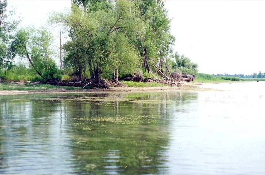
What is Protected Area Management?
                Management includes monitoring wildlife, maintaining and improving wildlife habitat,
       periodic inspections, enforcement of regulations, as well as the maintenance of facilities and
       infrastructure. Research is also an important activity in protected areas; hence, Environment
       Canada staff carries out or coordinates research in some sites.

       The Series
                All of the National Wildlife Areas are to have a management plan. All of these
       management plans will be initially reviewed five years after the approval of the first plan, and
       every ten years thereafter.

       To Learn More
                To learn more about Environment Canada’s protected areas, please visit our website at
       www.ec.gc.ca/ap-pa or contact the Canadian Wildlife Service.

ii   Îles de la Paix National Wildlife Area Management Plan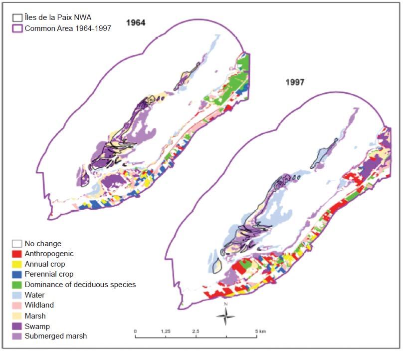
Îles de la Paix National Wildlife Area
       The Îles de la Paix National Wildlife Area is an archipelago that extends about five
kilometres in the Lake Saint-Louis, a natural widening of the St. Lawrence River southwest of
Montréal, in a highly urbanized and industrialized region. These islands are located next to the
St. Lawrence Seaway, one of the most important navigable waterways in North America.
Created in 1977 by Environment Canada, this National Wildlife Area (NWA) aims to protect
important waterfowl breeding habitats and a popular staging area for migratory birds.
       This 120-hectare protected area is an archipelago consisting of low islands surrounded
by beaches and wetlands and covered by open environments and sparse stands of Silver
Maple. Despite its small area, the NWA supports a diversity of habitats that are used by close to
130 species of birds. They provide nesting sites for dozens of breeding pairs of ducks, as well as
food and refuge for close to 5000 ducks during the spring migration and close to 30 000 ducks
during the fall migration. The NWA is home to over 150 animal species and over 50 plant
species, some of which are species at risk.
       A number of birds use the Îles de la Paix during the breeding period. The Black Duck, the
Mallard, the Blue-winged Teal, the Green-winged Teal and the Northern Pintail nest along the
edge of the islands and sometimes, when water levels are high, in the forks of trees. Dead trees
on the islands support a large roost of Tree Swallows. The Black Tern forms large colonies in
the islands’ marshes. A few mammals also use the area, among them the Muskrat, which
frequent the islands’ shores and cattail marshes, the Beaver, the American Mink and sometimes,
in winter, the Coyote and the Red Fox.
       The NWA faces major threats and management challenges associated, among other
things, with its proximity to a large urban area and current and past human activities. The main
threats are shoreline erosion, the impact of human activities on the NWA and the invasion by
plant species. Other threats and challenges to the management of the reserve include hunting
and poaching, scientific knowledge gaps, Lake Saint-Louis contaminated sediments, and
accidental spills.
       Given the sensitive nature of the wildlife species and habitats on the islands, access and
practice of activities in the Îles de la Paix NWA are prohibited, except under the authority of a
permit issued by the Minister. A permit can be issued for scientific activities aligned with the
priorities set out in the management plan, such as surveys, and habitat enhancement works or
restoration.

                                                       Îles de la Paix National Wildlife Area Management Plan   iii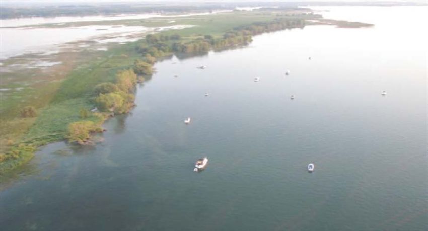
The goals of the management plan are to: 1) reduce the impacts of human activities on
       the NWA; 2) conserve and enhance significant habitats for species at risk, priority bird species,
       and other wildlife species; 3) reduce the effects of shoreline erosion; 4) ensure monitoring of the
       ecological integrity of the NWA and improve knowledge on wildlife species and their habitats.
               The plan is developed over a 10-year horizon and will be implemented as human and
       financial resources allow.

               For greater certainty, nothing in this management plan shall be construed so as to
       abrogate or derogate from the protection provided for existing Aboriginal or treaty rights of the
       Aboriginal peoples of Canada by the recognition and affirmation of those rights in section 35 of
       the Constitution Act, 1982.

iv   Îles de la Paix National Wildlife Area Management Plan
Table of Contents

1    DESCRIPTION OF THE PROTECTED AREA .................................................................... 1
    1.1 Regional Context .......................................................................................................... 4
    1.2 Historical Background ................................................................................................... 6
    1.3     Land Ownership ........................................................................................................... 7
    1.4     Installations and Infrastruture ........................................................................................ 8
2    ECOLOGICAL RESOURCES ............................................................................................. 9
    2.1 Terrestrial and Aquatic Habitats .................................................................................... 9
    2.2 Wildlife Species .......................................................................................................... 11
       2.2.1 Invertebrates ..................................................................................................... 11
       2.2.2 Fish ................................................................................................................... 11
       2.2.3 Amphibians and Reptiles ................................................................................... 12
       2.2.4 Birds .................................................................................................................. 12
       2.2.5 Mammals ........................................................................................................... 13
    2.3 Species at Risk ........................................................................................................... 14
3    MANAGEMENT CHALLENGES AND THREATS ............................................................. 16
    3.1 Shoreline Erosion ....................................................................................................... 16
    3.2 Impact of Human on the NWA .................................................................................... 17
    3.3 Invasion by Plant and Animal Species ........................................................................ 17
    3.4 Hunting and Poaching ................................................................................................ 17
    3.5 Scientific Knowledge Gaps ......................................................................................... 18
    3.6 Contaminated Sediments............................................................................................ 18
    3.7 Accidental Spills ......................................................................................................... 18
4    GOALS AND OBJECTIVES ............................................................................................. 19
    4.1 Vision.......................................................................................................................... 19
    4.2 Goals and Objectives .................................................................................................. 19
    4.3 Evaluation ................................................................................................................... 20
5    MANAGEMENT APPROACHES ...................................................................................... 21
6    AUTHORIZATIONS AND PROHIBITIONS ....................................................................... 24
    6.1 Prohibition of Entry ..................................................................................................... 24
    6.2 Authorized Activities ................................................................................................... 24
    6.3 Authorizations ............................................................................................................. 25
    6.4 Exceptions .................................................................................................................. 25
    6.5     Other Federal and Provincial Authorizations ............................................................... 26
7 HEALTH AND SAFETY .................................................................................................... 27
8 ENFORCEMENT ............................................................................................................... 28
9 PLAN IMPLEMENTATION................................................................................................ 29
10 COLLABORATORS .......................................................................................................... 30
11 LITERATURE CITED ........................................................................................................ 33
APPENDIX I : NOTICE FROM ENVIRONNEMENT CANADA PUBLISHED IN 2011 ............. 38

                                                                            Îles de la Paix National Wildlife Area Management Plan            v
1 DESCRIPTION OF THE PROTECTED AREA
The Îles de la Paix National Wildlife Area (NWA) was created in 1977 by Environment
Canada to protect important waterfowl habitats and a popular staging area for migratory birds.
The NWA is comprised of low islands fringed by beaches and wetlands, and offers a unique
ecosystem for various species of plants and animals in a heavily urbanized and industrialized
region. The archipelago is about five kilometres long and is located in Lake Saint-Louis, a
widening of the St. Lawrence River approximately 20 kilometres of Montréal in southwestern
Quebec (Figure 1).
Table 1: Information on Îles de la Paix National Wildlife Area
Protected Area (PA) Designation National Wildlife Area
Province or Territory Quebec – municipalities of Beauharnois and Léry
RCM of Beauharnois-Salaberry and RCM of Roussillon
Latitude and Longitude 45°20' N 73°54' W
Size 120 ha
Protected Areas Selection Historic:
Criteria Created to protect wetlands providing important waterfowl breeding
1 areas and a popular staging area for migratory birds.
(Protected Areas Manual)
Current:
Criterion 2a – The area supports an appreciable assemblage of
rare, vulnerable, threatened or endangered species or subspecies
of plants or animals, or an appreciable number of individuals of any
one or more of these species or subspecies. For this NWA: The
area supports an appreciable number of individuals of the Green
Dragon, a plant species designated threatened by the Government
of Quebec.
Criterion 2b – The area has special value for maintaining the
genetic and ecological diversity of a region because of the quality
and uniqueness of its flora and fauna. For this NWA: The area
supports a diversified and unique fauna and flora.
PA Classification System Category A – Species or critical habitat conservation
(Protected Areas Manual)
International Union for Category Ia – Strict nature reserve
Conservation of Nature
2
Classification (UICN )
Order-in-Council Numbers C.P. 1977-2958, C.P. 1978-1439, C.P. 1995-1445
Directory of Federal Real 67462
Property (DFRP) Number
Gazetted 1977, 1978, 1995
Îles de la Paix National Wildlife Area Management Plan 1Table 1: Information on Îles de la Paix National Wildlife Area (continued)
Other Designations Îles de la Paix Migratory Bird Sanctuary, which includes the islands
of the NWA and the surrounding waters within a radius of 500 m,
for the most part; Important Bird Area (IBA “Lac Saint-Louis et Îles-
de-la-Paix”).
Faunistic and Floristic Wetlands and islands forming important breeding areas for birds
Importance and a popular staging area for migratory birds. Presence of
species at risk.
Invasive Species Presence of two invasive plant species: the Reed Canary Grass
and the Purple Loosestrife. In the grass beds surrounding the
NWA, presence of the Zebra Mussel and the Quagga Mussel.
Species at Risk The NWA supports 3 species at risk under the federal Species at
Risk Act, including the Green Dragon and the Snapping Turtle, and
10 species designated threatened or vulnerable or likely to be so
designated in Quebec under the provincial Act respecting
threatened or vulnerable species, including the Hoary Bat.
Management Agency Environment Canada – Canadian Wildlife Service
Public Access and Use Access prohibited. Permits can be issued for activities related to
the conservation of species and habitats.
1
Environment Canada, 2005
2
UICN
2 Îles de la Paix National Wildlife Area Management PlanFigure 1: Îles de la Paix National Wildlife Area
Note: The boundaries of the islands changed over time due to shoreline erosion and land flooding. The current
configuration of the islands does not correspond to the original official boundaries of the NWA because portions of
the territory have been submerged.
Îles de la Paix National Wildlife Area Management Plan 31.1 REGIONAL CONTEXT
The Îles de la Paix consist of low-lying, low-relief alluvial stretches, most of which are part
of the Îles de la Paix Natural Wildlife Area. The NWA is located within the municipalities of
Beauharnois and Léry in the Lake Saint-Louis, a natural widening of the St. Lawrence River,
roughly 20 kilometres southwest of Montreal (Figure 2). The islands are located next to one of
the most important navigable waterways in North America: the St. Lawrence Seaway.
Figure 2: Aerial view of a sector of the Îles de la Paix National Wildlife Area
Photo: © Society for the Protection of Parc des Îles-de-la-Paix
The municipality of Beauharnois has a population of 11 918 people, among which 2808
live in the district of Maple Grove, and the municipality of Léry has 2385 people. The economic
activity of the regional county municipality of Beauharnois-Salaberry is strongly influenced by the
proximity of a large urban centre, metallurgical industries and a hydroelectric dam. The shoreline
is heavily urbanized, but agriculture is still covering most of the area. Lake Saint-Louis is heavily
used by recreational boaters and water sports enthusiasts and is home to the second largest
marina in Quebec.
The Îles de la Paix archipelago is exposed to severe environmental stresses. The islands
are particularly sensitive to high water levels (that may be due to the artificial regulation of Lake
Saint-Louis for navigation and hydroelectric power production). They are also affected by wind
and water erosion. It appears that shoreline erosion has slowed since 2001 but can nonetheless
4 Îles de la Paix National Wildlife Area Management Planexceed one meter a year in some of the more highly exposed sectors of the islands, such as La
Grande Île, Île Ronde and Île aux Plaines (Figure 1). In 1964, more than 90% of the NWA
habitats were swamps and marshes (Figure 3). In 1997, swamps and marshes occupied no
more than 30% of the area (Figure 4); these major changes are likely associated with high water
levels that occurred between the 1970s and the mid-1980s (Canadian Wildlife Service, 2003).
The area of marshes and submerged marshes increased from 5% to 45% of the area during that
period (Labrecque and Jobin, 2013).
The islands of the NWA act as a natural breakwater and protect the south shore of Lake
Saint-Louis from severe erosion. They also provide a high-quality staging area for waterfowl
during the migration, thus creating opportunities for fall hunting activities in the waters
surrounding the NWA, and generating economic benefits for local communities.
Although access to the islands is prohibited, the beauty of the surrounding landscape and
the sheltered waters around the islands attract recreational boaters, kayakers and canoeists,
bird watchers, and recreational fishers.
Figure 3: Comparison of the distribution of habitats in 1964 and 1997 following the rise in water
levels in the Îles de la Paix National Wildlife Area
(Taken from Labrecque and Jobin, 2013)
Îles de la Paix National Wildlife Area Management Plan 5Figure 4: Île à Tambault in 1999; shoreline erosion can be seen
Photo: Denis Lehoux © Environment Canada, Canadian Wildlife Service
1.2 HISTORICAL BACKGROUND
A string of islands in the middle of game-filled waters, the Îles de la Paix was an
Aboriginal camp and fishing base for close to 3000 years, as evidenced by artifacts recovered
from the islands. At the time of settlement in the 17th century, the islands were part of the
seigneury of Île Perrot. In the following century, the seigneurial rights to the islands were
gradually transferred, by either inheritance or sale, to various owners. One of the owners was
Marguerite Dufrost de la Jemmeraye, the widow of François Madeleine Youville, better known as
Marguerite d’Youville, the director of the General Hospital of Montréal and the founder of the
Grey Nuns of Montréal religious order (Ringuet and de Repentigny, 1986). Two centuries later,
on November 24, 1967, the order sold most of the archipelago (11 islands) to the Government of
Canada.
The archives of the Grey Nuns of Montréal provides a better understanding of the use of
the area prior to its purchase by the federal government. They contain agreements between the
religious order and individuals for activities on the islands, such as wood collecting and timber
harvesting; in return, these individuals committed to maintain the areas and to ensure some
6 Îles de la Paix National Wildlife Area Management Plandegree of surveillance. It seems that the Îles de la Paix was once used as pasture, and that in
the 19th and early 20th centuries, beach hay (foin de mer) was harvested there.
More recently, Ringuet et de Repentigny (1986) mention that sporadic fishing has taken
place in Lake Saint-Louis for several centuries. In the spring, the Yellow Perch (Perca
flavescens) is particularly abundant. In summer, the Brown Trout (Salmo trutta), the Northern
Pike (Esox lucius), the Muskellunge (Esox maskinongy), the Smallmouth Bass (Micropterus
dolomieu), the Largemouth Bass (Micropterus salmoides) and the Walleye (Stizostedion
vitreum) are highly sought after. The authors also mention that waterfowl hunting is associated
with the abundance of waterfowl habitats on Lake Saint-Louis. Every year, hunters fill their bags
with 15 000 aquatic birds. This surprising abundance confirmed in the 1980s the need to protect
waterfowl and its habitat in Lake Saint-Louis.
Given their location in the heart of a highly urbanized and industrialized region, the Îles
de la Paix are, in a sense, one of the only areas left that are still suitable for aquatic birds and
diversified wildlife in the greater Montréal area. By 1967, the Government of Canada already
owned a large part of the Îles de la Paix, and consolidated the territory by expropriating three
other islands in 1968. On March 7, 1973, the Canadian Wildlife Service of Environment Canada,
which was responsible for managing the site, established the Îles de la Paix Migratory Bird
Sanctuary. That status applied only to dry land and was designed to protect birds that
frequented the islands in large numbers (Ringuet and de Repentigny, 1986). In 1977, with the
promulgation of the Canada Wildlife Act, the same islands became the Îles de la Paix National
Wildlife Area. This dual status for the islands remained until 1980, when the sanctuary status
was eliminated, only to be restored in 1986, with the addition of a 500-metre perimeter around
most of the islands (Figure 1).
Today, many human communities are established close to the reserve, notably in Léry
and Beauharnois. Vibrant Mohawk communities still exist in the area and utilize the lands for
traditional pursuits.
1.3 LAND OWNERSHIP
All of the islands that form the NWA are owned by the Government of Canada since they
were acquired through purchase and/or expropriation in the 1960s. They are managed by
Environment Canada. However, other islands in the archipelago are privately owned, namely Île
Ronde (or Île Lucas), Île du Rapide (or Île du Docteur) and two unnamed islands. The islands
once covered a much larger area (121 ha), but have been exposed to the rising water levels and
to significant wave-induced erosion. A large part of the land area that was initially protected was
Îles de la Paix National Wildlife Area Management Plan 7lost to erosion and transformed into shoals (Figure 3). As a result, there is some ambiguity with
respect to title to land that has been eroded and submerged.
1.4 INSTALLATIONS AND INFRASTRUTURE
There are no facilities or infrastructure in the Îles de la Paix NWA. However, signs
installed at various locations within the area describe the regulations and indicate the
boundaries of the NWA.
8 Îles de la Paix National Wildlife Area Management Plan2 ECOLOGICAL RESOURCES
2.1 TERRESTRIAL AND AQUATIC HABITATS
The Îles de la Paix are so low-lying that, from the south shore of Lake Saint-Louis, they
appear as a distant mirage. The central part of most of the islands is lower than the shoreline,
forming a depression colonized by a succession of plant species ranging from wetland plain
vegetation to swamp vegetation (Figure 5). The gently sloped shore is clayey or sandy to the
north, on the channel side, and is exposed to waves and spring flooding. Due to their exposure
to high water levels and erosion, the Îles de la Paix have undergone significant recession rates
(Dauphin and Lehoux, 2003; Labrecque and Jobin, 2013). Changes have thus occurred in the
composition of the habitats. Today, tall grass prairies and forests are the main habitats available
in the islands (Lehoux et al., 2003, in Rivard and Giguère, 2014). The islands are bordered by a
marsh, primarily on the south side of the archipelago. The shallow water zone (less than 1 m
deep) covers over 1000 hectares around the islands.
Over 51 plant species occur in the NWA. The shoreline vegetation of the islands varies
from west to east. The westernmost islands (Île à Thomas, Île du Rapide, La Grande Île) are
characterized by forests (dead woodlands) dominated by the Red Maple (Acer rubrum) or Silver
Maple (Acer saccharinum) invaded by emergent hydrophytes. On higher areas of the islands,
there are forests that have been exposed to exceptionally high water levels in the 1970s and
1980s (stressed woodlands). These forests shelter the Reed Canary Grass (Phalaris
arundinacea), Rice Cutgrass (Leersia oryzoides) and Purple Loosestrife (Lythrum salicaria). The
highest points on the island, in the generally most sheltered southeast areas, are characterized
by Silver Maple stands with the Canada Nettle (Laportea canadensis) or Reed Canary Grass.
The maple stands contain a high diversity of other species, including the Gray Birch (Betula
populifolia), American Ash (Fraxinus americana) and Basswood (Tilia americana). The shrub
layer is composed of the Common Buttonbush (Cephalanthus occidentalis), Common
Winterberry (Ilex verticillata) and Staghorn Sumac (Rhus typhyna).
The easternmost islands are colonized primarily by stressed woodlands or forests that
shelter the Reed Canary Grass, Rice Cutgrass and Purple Loosestrife (Figure 6). There is an
area of generally very dense herbaceous meadows, primarily graminoids. At a lower elevation,
the herbaceous meadows comprise emergent hydrophytes, such as the Giant Bur-Reed
(Sparganium eurycarpum), the Common Cattail (Typha latifolia) and the Broadleaf Arrowhead
(Sagittaria latifolia), species typical of aquatic habitats (Gratton and Mousseau, 1985).
Îles de la Paix National Wildlife Area Management Plan 9In the southern part of the archipelago, the islands are sheltered from the winds and
currents, which is favourable to the growth of floating aquatic plants. The dominant species is
the Tuberous Water Lily (Nymphaea tuberosa), and companion species include the Canada
Waterweed (Elodea canadensis), the Tape Grass (Vallisneria americana), the Water Star-Grass
(Heteranthera dubia), the Nitella (Nitella sp.) and the Ivy-leaved Duckweed (Lemna trisulca)
(Grondin et al., 1983).
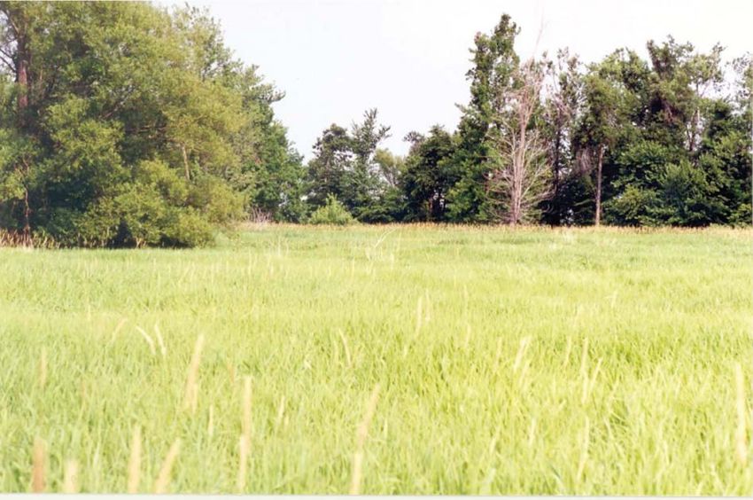
Figure 5: La Grande Île in 1999 – terrestrial habitats and marsh
Photo: Denis Lehoux © Environment Canada, Canadian Wildlife Service
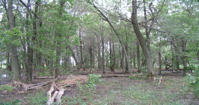
Figure 6: L’île aux Plaines in 2011 – forest subject to water level variations
Photo: Benoît Roberge © Environment Canada, Canadian Wildlife Service
10 Îles de la Paix National Wildlife Area Management Plan2.2 WILDLIFE SPECIES
Despite the loss of habitats due to severe shoreline erosion, the NWA supports a wide
variety of animal species in a relatively limited space given the diversity of habitats offered by its
extensive grass beds and wetlands. Animal inventories conducted in 2004 by the Canadian
Wildlife Service (Rivard and Giguère, 2014) have shown that the archipelago supports over
11 mammal species, some 130 bird species, 3 reptile species and 5 amphibian species. In the
surrounding waters, 41 fish species, 9 mollusc species (freshwater mussels) and invertebrates
of over 70 taxa were recorded.
2.2.1 Invertebrates
The waters around the Îles de la Paix make the NWA a unique environment that supports
a rich diversity and abundance of benthic wildlife dominated by gastropods, oligochaetes,
amphipods and pelecypods (Ferraris, 1984a, b). These invertebrates are an important food
source for many wildlife species, particularly fish and waterfowl. Surveys of benthic fauna
conducted in Lake Saint-Louis and along the Îles de la Paix (Levasseur, 1977; Ferraris,
1984a, b; Jacquaz, 1995) revealed over 70 taxa. Although probably incomplete, this portrait
indicates that the benthic fauna in the sector is relatively diversified on account of the large
variety of aquatic habitats. There are no data on the insects present in the Îles de la Paix. As
regards molluscs, a survey of freshwater mussel shells collected on the shores was conducted
in 2004 (Rivard and Giguère, 2014). Nine species were recorded in the survey, with Zebra
Mussel (Dreissena polymorpha) clearly being the dominant species in the shellfish areas
surveyed.
2.2.2 Fish
Spawning by two species, namely the Largemouth Bass and the Yellow Perch, has been
confirmed around the Îles de la Paix. Potential spawning areas have been found for the following
9 other species: the Bowfin (Amia calva), the Rock Bass (Ambloplites rupestris), the Common
Carp (Cyprinus carpio), the Northern Pike, the Catfish (Ameiurus nebulosus), the Channel
Catfish (Ictalurus punctatus), the Pumpkinseed (Lepomis gibbosus), the Burbot (Lota lota) and
the Black Cappie (Pomoxis nigromaculatus) (Gravel and Pageau, 1976; Mongeau and Massé,
1976; Pageau and Tanguay, 1977). A total of 41 species were recorded in the waters
surrounding the Îles de la Paix. Most recent surveys have found about 20 species of fish (La
Violette et al., 2003).
Îles de la Paix National Wildlife Area Management Plan 112.2.3 Amphibians and Reptiles
According to the database of the Atlas of Amphibians and Reptiles of Quebec (Source:
David Rodrigue, Société d’histoire naturelle de la vallée du Saint-Laurent, 2002), three species
occur in the islands: the Common Mudpuppy (Necturus maculosus), which is present in the
waters surrounding the islands, the Snapping Turtle (Chelydra serpentina) and the Painted
Turtle (Chrysemys picta). In the surveys and field visits by the Canadian Wildlife Service in 2004,
the following species were also recorded in the NWA: the Wood Frog (Rana sylvatica), the
Northern Leopard Frog (Rana pipiens), the Spring Peeper (Pseudacris crucifer), the Common
Garter Snake (Thamnophis sirtalis), the Painted Turtle and the American Bullfrog (Lithobates
catesbeianus). The Eastern American Toad (Bufo americanus americanus) was also reported on
the archipelago (Ringuet and de Repentigny, 1986). The Green Frog (Rana clamitans) was
observed on the mainland in the Maple Grove sector at Beauharnois and could possibly be
present on the Îles de la Paix.
2.2.4 Birds
Despite the small size of the area, close to 130 bird species have been surveyed in the
NWA and immediate vicinity, most of which are in transit (ÉPOQ, 2011). Over 60 bird species
were counted specifically on the islands, and of that number, more than 20 nesting species
(Ringuet and de Repentigny, 1986; Rivard and Giguère, 2014). In the late 1960s and early
1970s, some 70 duck nests were inventoried each year. Due to spring flooding, the Mallard
(Anas platyrhynchos) and the American Black Duck (Anas rubripes), the two main nesting
species, had adapted to nesting in trees in order to protect their nests from flooding (Laperle,
1970). In addition to these two species, high densities of the Blue-winged Teal (Anas discors)
and the Northern Pintail (Anas acuta) were also recorded. Today, the majority of woodlands are
stressed or dead due to the high water levels (Figure 6), and the sparsely populated forests no
longer provide the necessary shelter against predators (Ringuet and de Repentigny, 1986).
However, the vast marshes of the Îles de la Paix continue to offer a high-value habitat for brood
rearing. In a 2001 survey, a colony of 60 to 70 Great Blue Herons (Ardea herodias) was
recorded on Île à Thomas, and several nests were observed in 2004 (Rivard and Giguère,
2014). In 1998, a colony of 90 Double-crested Cormorants (Phalacrocorax auritus) was seen on
Île à Tambault. However, it disappeared in 1999 (Canadian Wildlife Service, 2003), possibly as a
result of several factors as habitat degradation or human disturbance.
The dead forests provide breeding habitat for the Tree Swallow (Tachycineta bicolor),
and the marshes serve as nesting and brood-rearing habitat for the Black Tern (Chlidonias
12 Îles de la Paix National Wildlife Area Management Planniger) (Ringuet and de Repentigny, 1982, in de Repentigny, 1988). Other breeding bird species
present in the NWA include the Pied-billed Grebe (Podilymbus podiceps), the Green Heron
(Butorides virescens), the Common Gallinule (Gallinula galeata), the Spotted Sandpiper (Actitis
macularius), the Mourning Dove (Zenaida macroura), the Eastern Screech Owl (Megascops
asio), the Marsh Wren (Cistothorus palustris) and the Red-winged Blackbird (Agelaius
phoeniceus). The Blackcrowned Night-Heron (Nycticorax nycticorax) and the Great Blue Heron
are also present during the nesting period.
The Îles de la Paix also serve as a staging area for migrating waterfowl (Canadian
Wildlife Service, 2003) and are used by the Mallard, the Black Duck, the American Widgeon
(Anas americana) and the Northern Pintail. Diving ducks, such as the Common Goldeneye
(Bucephala clangula), the Bufflehead (Bucephala albeola) and the Ring-necked Duck (Aythya
collaris), also occur at the site. In addition, large numbers of Canada Geese (Branta canadensis)
(over 500 individuals) gather in the waters north of the archipelago in the spring (Denis Labonté,
CWS, pers. comm., 2010). Over 5000 ducks are also present around the Îles de la Paix during
this period, and as many as 30 000 birds can be found in the NWA during the fall migration (de
Repentigny, 1988). The diversity of habitats attracts many other groups of birds, such as
passerines, terns and gulls.
2.2.5 Mammals
The natural (unaltered) shorelines of the Îles de la Paix combined with the presence of
emergent marshes and swamps provide high-quality habitats for the Muskrat (Ondatra
zibethicus), which is abundant on the islands (Marsan et ass., 1986; Armellin et al., 1994). The
Beaver (Castor canadensis) and the American Mink (Neovison vison) are also present
(Canadian Wildlife Service, 2003). The Red Fox (Vulpes vulpes) and the Coyote (Canis latrans)
can been observed on the Îles de la Paix in winter. Surveys carried out in 2004 (Rivard and
Giguère, 2014) allowed to identify only one micromammal species in the NWA, the Meadow
Vole (Microtus pennsylvanicus). They also revealed the presence (using recordings) of one to
three species of bats in the NWA or in its immediate vicinity. The Hoary Bat (Lasiurus cinereus)
was clearly identified. One of the recordings is undoubtedly that the presence of the Big Brown
Bat (Eptesicus fuscus) or the Silver-haired Bat (Lasionycteris noctivagans), but the sonogram
does not allow to confirm the identification.
Îles de la Paix National Wildlife Area Management Plan 132.3 SPECIES AT RISK
The Îles de la Paix NWA supports a diversity of plant and animal species, among which
three have been designated “at risk” under the Species at Risk Act, and ten have been or are
likely to be designated threatened or vulnerable in Quebec under the province’s Act respecting
threatened or vulnerable species (ARTVS) (Table 2). Surveys were conducted in 2004 (Rivard
and Giguère, 2014) to obtain a more up-to-date picture of the presence of these species in the
NWA.
The Caspian Tern (Hydroprogne caspia) is the only species of migratory bird at risk that
was reported in the vicinity of the NWA during the surveys of 2004 (Savard and Giguère, in
prep.). The presence of the Hoary Bat, a species likely to be designated threatened or
vulnerable in Quebec, has been confirmed during the 2004 surveys (Rivard and Giguère, 2014).
Another species likely to be so designated, the Silver-haired Bat, could be present in the NWA,
but this remains to be confirmed (see Mammals above).
Egg-laying signs of the Snapping Turtle and the Northern Map Turtle (Graptemys
geographica) were observed on the Îles de la Paix, as well as suitable habitats for these
species. The Brown Snake (Storeria dekayi) and the Northern Watersnake (Nerodia sipedon
sipedon), two species likely to be designated threatened or vulnerable in Quebec, as well as the
Western Chorus Frog (Pseudacris triseriata), a species designated threatened under the SARA
and vulnerable under the ARTVS, are present near the Îles de la Paix, but observation of these
species has not yet been reported in the NWA (Rivard and Giguère, 2014; CDPNQ, 2014). It is
unlikely that these species will frequent the NWA.
A large colony of the Green Dragon (Arisaema dracontium) occurs in the NWA, as well
as the Swamp White Oak (Quercus bicolor) and four other species of vascular plants. Records
of five other plant species likely to be designated threatened or vulnerable under the ARTVS are
listed in the database of the Centre de données sur le patrimoine naturel du Québec: Arabia
laevigata, Cardamine concatenata, Neobeckia aquatica, Potamogeton pusillus subsp.
gemniparus and Zizania aquatica var. aquatica. The majority of these last observations were
made in 1965 and have not been validated.
14 Îles de la Paix National Wildlife Area Management PlanTable 2: Species at Risk in the Îles de la Paix National Wildlife Area
Statut
Common and Scientific Names
Canada Quebec
of the Species 1 2 3
SARA COSEWIC ARTVS
Birds
Caspian Tern
No status Not at risk Threatened
Hydroprogne caspia
Mammals
Silver-haired Bat 4
No status No status SLDTV
Lasionycteris noctivagans
Hoary Bat 4
No status No status SLDTV
Lasiurus cinereus
Reptiles
Common Map Turtle
Special concern Special concern Vulnerable
Graptemys geographica
Snapping Turtle
Special concern Special concern No status
Chelydra serpentine
Vascular Plants
Green Dragon
Special concern Special concern Threatened
Arisaema dracontium
Narrow-leaved Blue-eyed Grass 4
No status No status SLDTV
Sisyrinchium angustifolium
Swamp White Oak 4
No status No status SLDTV
Quercus bicolor
Rusty Flatsedge 4
No status No status SLDTV
Cyperus odoratus
LeConte’s Violet 4
No status No status SLDTV
Viola affinis
Northern Watermeal 4
No status No status SLDTV
Wolffia borealis
1 Canada Species at Risk Act (Species at Risk Public Registry, 2014)
2 Committee on the Status of Endangered Wildlife in Canada (COSEWIC, 2014)
3 Quebec Act Respecting Threatened or Vulnerable Species (MDDELCC, 2014 and MFFP, 2014)
4 Species likely to be designated threatened or vulnerable in Quebec (MDDELCC, 2014 and MFFP, 2014)
Îles de la Paix National Wildlife Area Management Plan 153 MANAGEMENT CHALLENGES AND THREATS
The Îles de la Paix NWA is facing many management threats and challenges, which are
largely related to the proximity of a large urban area and to present and past human activities. A
study conducted by Environment Canada in 2003 indicates that the ecological integrity of the
NWA was not sufficient to meet its conservation objectives (Canadian Wildlife Service, 2003).
Nowadays, the state of ecological integrity of the NWA is probably similar to that observed in
2003, or may even have deteriorated, notably because of the islands’ loss of area due to
erosion. The main threats associated with the ecological integrity of the Îles de la Paix NWA are
shoreline erosion, impact of human activities on the NWA and invasion by plant species. They
are described below in descending order of importance according to the current state of
knowledge.
3.1 SHORELINE EROSION
Erosion of the shorelines is one of the most serious threats on the Îles de la Paix NWA
since it causes riparian habitat destruction, species loss and ecosystem modifications. Winds,
ice and waves as well as high water levels in part related to the regulation of the St. Lawrence
water levels (or flow) and observed mainly in the 1970s and 1980s (Canadian Wildlife Service,
2003) have resulted in the loss of forested areas on the islands (except on the higher parts) and
in shoreline erosion of more than one meter a year in some areas, such as La Grande Île, Île
Ronde and Île aux Plaines.
Over the years, the NWA has shrunk considerably in size, with shoreline recessions of
approximately 64 metres over a 33-year period on some islands (Labrecque and Jobin, 2013). In
an effort to limit the risk of shoreline erosion, dikes were constructed by the Society for the
Protection of Parc des Îles-de-la-Paix. In 2001, a 200-metre dike was built between Île Napoléon
(or Île du Gardien) and Île à Tambault. In addition, a 200-metre dike was constructed in 2009
beside La Grande Île and a 100-metre long riprap was installed on the east side of the dike.
These efforts appear to have contributed to reducing erosion. In 2012, the authorities
responsible for constructing highway 30 (NA30) built, as a fish habitat compensation measure,
three 50-metre dikes and three breakwater islets north of Île à Tambault. Lastly, in 2013, a 50-
metre dike was installed west of Île aux Plaines.
16 Îles de la Paix National Wildlife Area Management Plan3.2 IMPACT OF HUMAN ON THE NWA
Given the proximity of Montréal and the large population in the region, the Îles de la Paix
NWA attracts many visitors despite the regulations and signage prohibiting entry and the
presence of wildlife officers. A large number of recreational boaters and fishers, swimmers,
dead-wood collectors, picnickers and partiers, sometimes accompanied by dogs, illegally access
the islands of the NWA, disturbing birds during the breeding periods and trampling and
degrading habitat (plants). The impacts of these activities are particularly important during the
nesting and brood-rearing period, when species are very vulnerable to disturbance.
Unauthorized human presence also threatens the species at risk present on the islands.
3.3 INVASION BY PLANT AND ANIMAL SPECIES
Forests on the easternmost islands exposed to water-level fluctuations are colonized by
the Reed Canary Grass and the Purple Loosestrife, which are considered invasive species.
These species cover large areas and can cause losses of biodiversity and natural habitats. They
pose a serious threat to the ecological integrity of the NWA.
In the waters surrounding the NWA, two species of exotic mussels are present: the Zebra
Mussel and the Quagga Mussel (Dreissena bugensis). These species occur primarily in the
grass beds surrounding the islands. Mussels filter larger quantities of phytoplankton, and
compete with zooplankton species, a food source for young fish (OFAH, 2011). The Round
Goby (Neogobius melanostomus) and the Rusty Crayfish (Orconectes limosus) consume large
quantities of food and could compete for food resources with native fish species (OFAH, 2011).
Although not considered an invasive species, the so-called resident Canada Goose is
expanding its range in urban environments (parks, golf courses, etc.) and could nest in the
archipelago.
3.4 HUNTING AND POACHING
Although hunting is prohibited in the NWA, nearly 250 permits are issued annually for
hunting in the aquatic part of the Migratory Bird Sanctuary that surrounds the NWA (500 m
around the islands). The hunting of migratory birds in the sanctuary poses a major management
challenge in terms of surveillance and enforcement. The appropriateness of continuing to allow
migratory bird hunting in the sanctuary will have to be evaluated. Cases of migratory bird
poaching in the NWA have also been reported.
Îles de la Paix National Wildlife Area Management Plan 173.5 SCIENTIFIC KNOWLEDGE GAPS
The current state of knowledge of ecosystems is sometimes inadequate or obsolete,
particularly with respect to vegetation, habitats, certain bird and mammal species, and threats.
These knowledge gaps sometimes hinder proper assessment of the current state of ecological
integrity of the NWA and effective decision making on the management of the habitats and
species present.
3.6 CONTAMINATED SEDIMENTS
Many years of industrial releases in the Beauharnois region have contributed to the
contamination (pesticides, heavy metals) of lake sediments, particularly in the southern part of
the NWA (Environment Canada, 2011). The toxic products present in water or trapped in
sediments could accumulate in the food web of aquatic and terrestrial ecosystems.
3.7 ACCIDENTAL SPILLS
Many commercial vessels and recreational boats transit through the St. Lawrence
Seaway every year. They cross Lake Saint-Louis and therefore sail near the Îles de la Paix
NWA. An accidental spill of hydrocarbons or other chemicals from these ships into the waters
surrounding the islands could have serious repercussions on aquatic species, their habitats and
the ecosystem of the NWA.
18 Îles de la Paix National Wildlife Area Management Plan4 GOALS AND OBJECTIVES
4.1 VISION
The Îles de la Paix National Wildlife Area protects significant habitats for species at risk,
priority bird species and other wildlife species. Priority bird species are the species identified in
the Bird Conservation Strategy for Bird Conservation Region 13 in the Quebec Region: Lower
Great Lakes/St. Lawrence Plain (Environment Canada, 2013).
4.2 GOALS AND OBJECTIVES
The goals and objectives listed below are used to clarify the management plan vision,
taking into account the threats and management challenges. These goals and objectives will be
achieved by carrying out the actions identified in Table 3 (Management approaches for the Îles
de la Paix National Wildlife Area), which will be implemented in accordance with available
resources.
Goal 1: Reduce the impact of human activities on the NWA.
Objectives:
1.1 Determine the current boundaries of the NWA (islands, flooded lands and adjacent
grass beds) and post them in the field by means of signage in order to protect plants
and animals from the impacts of human activity (navigation, fishing, hunting and
disturbance).
1.2 Evaluate the appropriateness of continuing to allow migratory bird hunting in the
waters of the Migratory Bird Sanctuary (500 m around the islands).
1.3 Raise regional awareness of the purpose of the NWA and applicable regulations,
and obtain regional support.
1.4 Reduce the number of incidents of regulatory non-compliance.
1.5 Reduce the impacts of accidental spills.
Îles de la Paix National Wildlife Area Management Plan 19Goal 2: Protect and enhance significant habitats for species at risk, priority bird species and
other wildlife species.
Objectives:
2.1 Prevent and reduce the spread of invasive species.
2.2 Conserve wildlife species and their habitats.
2.3 Develop waterfowl nesting and brood-rearing habitats.
2.4 Assess the ecological potential of the archipelago islands that are not part of the
NWA and determine the significance of threats to which they are exposed.
Goal 3: Reduce the effects of shoreline erosion.
Objectives:
3.1 Assess the priorities and the appropriateness for restoring shorelines and habitats
and conduct the appropriate works if required.
3.2 Assess the feasibility of reforestation of high parts of the islands.
Goal 4: Ensure monitoring of the ecological integrity of the NWA and improve knowledge on
wildlife species and their habitats.
Objectives:
4.1 Fill priority knowledge gaps.
4.2 Establish an ecological monitoring program.
4.3 EVALUATION
An annual monitoring of the actions implemented and the results obtained will be
performed based on financial and human resources availability. This monitoring will be used to
establish priorities for action and resources. The management plan will be reviewed five years
after its initial approbation and every ten years following that.
20 Îles de la Paix National Wildlife Area Management Plan5 MANAGEMENT APPROACHES
Table 3, below, contains a description of all the possible actions that could be used in the
management of the Îles de la Paix NWA. However, specific management actions will be
determined during the annual work planning process and will be implemented as human and
financial resources allow.
Table 3: Management approaches for the Îles de la Paix National Wildlife Area
1
Goals Objectives Actions (Priority Level )
Goal 1: Reduce the Objective 1.1: Determine • Clarify legal title to the land and flooded grass
impact of human the current boundaries of beds. (1)
activities on the the NWA (islands, flooded • As required, review the legal boundaries of the
NWA. lands and adjacent grass NWA as per cadastral data. (1)
beds) and post them in the
• Review the legal description of the NWA. (1)
Threats and field by means of signage
in order to protect plants • Display the boundaries of the NWA around its
challenges: entire perimeter. (1)
and animals from the
• Impact of human impacts of human activity
activities on the (navigation, fishing, hunting
NWA and disturbance).
• Hunting and
poaching Objective 1.2: Evaluate • Assess the need to maintain the status and
the appropriateness of current boundaries of the Migratory Bird
• Scientific knowledge continuing to allow Sanctuary. (1)
gaps migratory bird hunting in • Examine the need to restrict the issuance of
• Accidental spills the water sector of the waterfowl hunting permits in the aquatic part of
Migratory Bird Sanctuary the Migratory Bird Sanctuary adjacent to the
(500 m around the islands). NWA. (1)
• Identify priority compliance promotion and
enforcement actions. (1)
Objective 1.3: Raise • Install signage in the NWA at all potential points
regional awareness of the of entry and at certain strategic points outside of
purpose of the NWA and the NWA. (1)
applicable regulations, and • Publish regularly public notices in newspapers
obtain regional support. concerning the regulations respecting the NWA
(1)
• Disseminate information on the importance of
the NWA and document the situation on an
ongoing basis with local partner organizations.
(1)
• Specify the role of stakeholders, Aboriginal
people and collaborators in public awareness
efforts. (1)
Îles de la Paix National Wildlife Area Management Plan 21Table 3: Management approaches for the Îles de la Paix National Wildlife Area (continued)
1
Goals Objectives Actions (Priority Level )
Objective 1.4: Reduce the • Identify surveillance and enforcement priorities
number of incidents of with Environment Canada Wildlife Enforcement
regulatory non-compliance. Directorate. (1)
• Promote an increase surveillance of the NWA by
law enforcement agents. (1)
Objective 1.5: Reduce the • Identify and keep up-to-date information on the
impacts of accidental spills. presence of species and location of their
habitats in order to ensure an effective response
in the event of accidental spills. (1)
Goal 2: Protect and Objective 2.1: Prevent and • Assess the extent of invasion by the Reed
enhance significant reduce the spread of Canary Grass and the Purple Loosestrife. (1)
habitats for species invasive species. • Develop and apply measures to stabilize (1) and
at risk, priority bird reduce (2) the size of Reed Canary Grass and
species and other Purple Loosestrife colonies.
wildlife species. Objective 2.2: Conserve • Implement the recommendations of all species
wildlife species and their at risk recovery planning documents within the
Threats and habitats. prescribed timeframes. (1)
challenges:
Objective 2.3: Develop • Examine measures and conservation status for
• Shoreline erosion waterfowl nesting and grass beds adjacent to the islands (flooded
• Invasion by plant brood-rearing habitats. lands) that form part of the NWA. (2)
species • Assess the ecological appropriateness and
• Scientific knowledge feasibility of actions such as habitat restoration,
gaps reforestation and nest boxes. (3)
• Develop priority waterfowl habitat enhancement.
(3)
Objective 2.4: Assess the • Assess the ecological potential of the four
ecological potential of the privately owned islands of the Îles de la Paix
archipelago islands that are archipelago. (2)
not part of the NWA and • Assess the significance of the threats and
determine the significance identify the conservation or protection measures
of threats to which they are of these islands. (2)
exposed.
Goal 3: Reduce the Objective 3.1: Assess the • Assess the current state of erosion of the NWA
effects of shoreline priorities and the islands and establish a monitoring system for
erosion. appropriateness for the erosion of the islands. (1)
restoring shorelines and • Identify priority shoreline and habitat restoration
Threats and habitats and conduct the work and assess their ecological
challenges: appropriate works if appropriateness and feasibility. (2)
required.
• Shoreline erosion • Document the potential impact of contaminated
sediments on habitat restoration. (2)
• Contaminated
sediments • In collaboration with local organizations, carry
out priority restoration works. (2)
22 Îles de la Paix National Wildlife Area Management PlanTable 3: Management approaches for the Îles de la Paix National Wildlife Area (continued)
1
Goals Objectives Actions (niveau de priorité )
Objective 3.2: Assess the • Assess the ecological relevance and feasibility
feasibility of reforesting of reforesting 3 ha of a targeted area in the
upper parts of the islands. upper parts of the islands. (2)
• Carry out priority reforestation works. (2)
Goal 4: Ensure Objective 4.1: Fill priority • Identify priority scientific and traditional
monitoring of the knowledge gaps. ecological knowledge gaps. (1)
ecological integrity • Include traditional ecological knowledge for the
of the NWA and ecosystems management of the reserve. (2)
improve knowledge
• Conduct surveys and monitoring of species at
on wildlife species
risk, stresses, sensitive habitats and the impacts
and their habitats.
of certain human activities in collaboration with
Aboriginals and other partners. (2)
Threats and
• Conduct studies and surveys of aquatic and
challenges: marsh birds in collaboration with Aboriginals and
• Impact of human other partners. (2)
activities on the • Establish research collaborations with
NWA universities and research centers. (2)
• Hunting and
poaching
Objective 4.2: Establish an • Determine the indicators and methodology of
ecological monitoring the monitoring program. (1)
• Scientific knowledge program.
gaps • Implement the ecological monitoring program.
(1)
• Use the expertise of Mohawks, local
conservation organizations and governments in
the implementation and analysis of the
ecological integrity monitoring. (2)
1
Level of Priority: 1 (from 0 to 3 years); 2 (from 4 to 6 years); 3 (from 7 to 10 years)
Note: The levels of priority assigned to the actions relate to the implementation schedule and not the significance
for resource conservation. They can change depending on the context and the available resources.
Îles de la Paix National Wildlife Area Management Plan 23You can also read