Flood ready Flood mapping implementation kit - Queensland
←
→
Page content transcription
If your browser does not render page correctly, please read the page content below

Department of Natural Resources and Mines

                   Flood
                      ready
                       Queensland
             Queensland Flood Mapping Program

Flood mapping implementation kit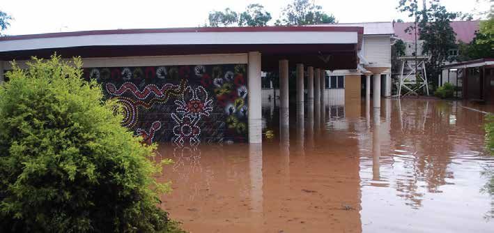
CS3662 10/14

Enquiries
All enquiries regarding this document should be directed to:
QFMP, Land and Spatial Information
Department of Natural Resources and Mines
Phone: 07 3896 3225 | Email: QFMP@dnrm.qld.gov.au

Version 1, October 2014

This publication has been compiled by the Queensland Flood Mapping Project (QFMP), Department of Natural Resources and Mines.
© State of Queensland, Department of Natural Resources and Mines 2014.
The Queensland Government supports and encourages the dissemination and exchange of its information. The copyright in this publication is
licensed under a Creative Commons Attribution 3.0 Australia (CC BY) licence.

Under this licence you are free, without having to seek our permission, to use this publication in accordance with the licence terms.
You must keep intact the copyright notice and attribute the State of Queensland as the source of the publication.
Note: Some content in this publication may have different licence terms as indicated.
For more information on this licence, visit http://creativecommons.org/licenses/by/3.0/au/deed.en.
The information contained herein is subject to change without notice. The Queensland Government shall not be liable for technical or other
errors or omissions contained herein. The reader/user accepts all risks and responsibility for losses, damages, costs and other consequences
resulting directly or indirectly from using this information.
Information security
This document has been classified using the Queensland Government Information Security Classification Framework (QGISCF) as public and will
be managed according the requirements of the QGISCF.

2 | Queensland Flood Mapping Program | October 2014 |
Contents
  About this document                                                                                    4
  Audience for the implementation kit                                                                    4

Introduction                                                                                             5

Background                                                                                              6
        Queensland Flood Mapping Program                                                                6
        Economic and community resilience framework                                                     7

Themes                                                                                                  8
  Theme 1: Land use planning                                                                            9
  Theme 2: Coastal management                                                                          11
  Theme 3: Building controls                                                                           12
  Theme 4: Structural works                                                                            14
  Theme 5: Infrastructure                                                                              16
  Theme 6: Landscape and environment                                                                   17
  Theme 7: Education and information                                                                   19
  Theme 8: Emergency management                                                                        20
         Element 1: Flood warnings                                                                     22
         Element 2: Public information                                                                 24
         Element 3: Evacuation and supplies                                                            25
         Element 4: Property protection                                                                25
  Theme 9: Insurance                                                                                   26

Action plans                                                                                           28
          Land use planning                                                                            28
          Building controls                                                                            28
          Coastal management                                                                           28
          Structural works                                                                             29
          Infrastructure                                                                               29
          Landscape and environment                                                                    29
          Education and information                                                                    30
          Emergency management                                                                         30
          Insurance                                                                                    31

                                                      | Queensland Flood Mapping Program | October 2014 | 3
About this document
Flood Ready Queensland – Flood Mapping Implementation Kit has been developed to assist a broad range of stakeholders
more effectively implement the outcomes of flood studies. In particular, it aims to increase the use of flood mapping
outputs, improving the community’s understanding of their exposure to flood risk and therefore strengthing economic
and community resilience.
The kit is intended to be a living document, that will be enhanced over time through feedback and comments. It aims to
encourage effective use of available flood information to:
•   improve community safety;
•   increase business resilience through preparedness and business continuity planning;
•   improve community resilience through increased awareness and preparedness to the hazard;
•   position local disaster management groups to be better prepared to respond to flood events;
•   reduce recovery costs borne by community, insurance industry and all levels of government.

Audience for the implementation kit
The primary audiences for this implementation kit are local governments and local disaster management groups (LDMGs).
The kit supports the effective use of flood mapping products provided by the Queensland Government through the Department
of Natural Resources and Mines (DNRM). The products are designed to assist the LDMG and council to continue to improve their
disaster management and land-use-planning outcomes.
The kit contains background information to enable readers irrespective of their responsibilities, to understand how flood
mapping products can strengthen a community’s resilience to flooding events.

4 | Queensland Flood Mapping Program | October 2014 |
Introduction
Since 2010, Queenslanders have experienced significant disaster events, including floods, cyclones, droughts and bushfires.
This has created financial burden on local communities, businesses and government agencies and the need to build a more
resilient state.
In June 2014, the Queensland Government released the Queensland Strategy for Disaster Resilience. It is based on the
understanding that building resilience to all hazards is vital to the future of the state. It identifies areas of focus and activities
to be undertaken to enhance the foundations of Queensland’s disaster resilience to all hazards. Importantly it recognises that,
a resilient community understands the risk of future disasters, including floods.
The vision of the Strategy is to make Queensland the most disaster resilient state in Australia. People who choose to live in hazard
prone areas of the state must be aware of the disaster risks and accept the responsibility to prepare for and manage, to the best
of their ability, their own response and recovery. This attitude of personal responsibility for resilience, as individuals and as a
community, is the way forward for Queensland.
The Strategy defines a resilient community as:

                   A resilient community is one that possesses the capacities, skills and knowledge that
                   enable it to prepare for, respond to, and recover effectively from a disaster and adapt
                   positively to a changing environment. It is a community that works together to understand
                   and manage the risks and vulnerabilities that it confronts, and enhances its capacity to
                   address its vulnerabilities to all hazards.

Historically, most of Queensland’s towns and communities have been established on or near floodplains and as a result the
likelihood of flooding that impacts the community remains. Given this exposure, comprehensive understanding of flood hazard
and risk can empower a community to become as resilient as practicable to flood events.
The Queensland Flood Mapping Program (QFMP) provides flood mapping information to assist in preventing, preparing,
responding and recovering from flood disaster. Implemented by DNRM, the QFMP delivers fit-for-purpose flood mapping to a large
number of flood prone towns across the state. The program aims to be consistent with national best practices1.

                         Queensland Strategy for Disaster Resilience is available at
                         http://dlgcrr.qld.gov.au/information-for-the-public/community-recovery-and-resilience.html

1   Managing the Floodplain – a guide to flood risk management in Australia – Handbook No. 7

                                                                                    | Queensland Flood Mapping Program | October 2014 | 5
Background
Queensland Flood Mapping Program
QFMP provides flood mapping information that assists in mitigating, preparing, responding and recovering from flood disaster.
The program aims to be consistent with national best practice.
Download a copy of Managing the floodplain: a guide to best practice in flood risk management in Australia (Handbook 7)
by AEMI from https://ema.infoservices.com.au/items/HB7-2ND
Established after the 2011 floods and now part of DNRM, the QFMP delivers fit-for-purpose flood mapping working closely with
a large range of stakeholders including council staff, hydrologists, technology, land use planning and emergency management
experts.
Fit-for-purpose maps are advocated as a result of recognising not all communities require the same level of mapping to ascertain
their flood risk. Figure 1 shows the three levels of fit-for-purpose flood mapping advocated. They are:
• Level 1. State-wide mapping known as the Queensland Floodplain Assessment Overlay. The overlay was developed through
the application of a consistent state-wide methodology;
• Level 2. Town-based mapping that focuses on lower growth towns; and
• Level 3. Comprehensive mapping required for densely populated, higher growth centres and more complicated investigation
areas such as coastal communities.
Figure 1: Different types of flood mapping methods
Responsibilities
State-wide National
Level 1 Town-based State
Level 2 Comprehensive Regional
Level 3 Local
Floodplain Extents Indicative Studies Detailed Studies
Across the State Low Growth Towns Major Centres
Queensland Floodplain Flood Studies
Assessment Overlay at Sub-Basin Levels
Fit for Purpose
Mitigation Options and Planning Controls Mapping
To date, the delivery of level 2 studies has been the QFMP’s key focus. These town-based flood investigations are prioritised on
the basis of the Bureau of Meteorology assessment of flood risk for each town and the availability of flood information required
to develop effective flood models.
A level 2 study provides a flood study report, flood mapping across at least three different flood events (ie. AEP 2%, 1%, 0.5%)
and details regarding depth, velocity and hazard. To date, over 100 towns have been completed through the QFMP.
An improvement for phase 3 of the program is the provision of flood maps for additional gauge heights to assist with
disaster management.
6 | Queensland Flood Mapping Program | October 2014 |Economic and community resilience framework
Figure 2 has been developed to allow local government authorities (LGA) and local disaster management groups (LDMG)
understand the key areas that benefit from consideration of information derived from the flood studies and their outputs.
Each key area is called a theme (e.g. land-use-planning or emergency management) and each theme is examined in more
detail in the following section of the kit. It is the coordinated delivery of all these themes that will deliver economic and
community resilience.
Figure 2: Economic and community resilience framework
Zoning
& urban Land use transition
design strategies
Planning Resumption Storm
operation Infrastructure programs Erosion surge
design areas Coincedence
Dams flooding
Business Roads
Land use planning
continuity Railways
Minimum
t
en
Flood flood levels
em
warning
ag
infr
Structural
an
em resilience
ast
Evacuation
erg
al m
& recovery en
ruc
plans cy ls
ast
Resilient
ma tro
tur
na n materials
Co
co
e
Impact ge
me g
din
understanding
nt l Premium
i
Hazard Bu calculations
awareness
education/i Insurance
nformation ReSpOnSe coverage
insurance
Learning from
experiences tO RiSk Customer
Riparian offerings
& wetland Stru
management ent ctura
environm l wo
rks
Engineering
e/ design
Erosion scap
control Land Fit for Purpose Levees
Strategic Risk Assessment (existing, new)
retention
management Simple Flood
gates
Complex
Fit for Purpose
Hazard Identification
Flood FLOOD Community
Information Mapping Engagement
| Queensland Flood Mapping Program | October 2014 | 7Themes
Each of these themes have been further explored in the table below:
Themes Area of interest
• Zoning & urban design
Land use planning • Land use strategies
• Resumption programs
• Storm surge
Coastal management • Erosion areas
• Coincidence flooding
• Minimum floor levels
Building controls • Resilient materials
• Structural resilience
• Engineering design
Structural works • Levees (existing, new)
• Flood gates
• Planning operations
Infrastructure • Dams, roads, railways
• Infrastructure design
• Riparian and wetland management
Landscape and environment • Erosion and sediment control
• Strategic vegetation management
• Hazard awareness
Education and information • Impact understanding
• Learning from experiences
• Flood warning
Emergency management • Business continuity
• Evacuation & recovery plans
• Premium calculations
Insurance • Insurance coverage
• Customer offerings
8 | Queensland Flood Mapping Program | October 2014 |Theme 1: Land use planning
Audience: local government; local disaster management groups; planning agencies
Introduction | Why is this important?
Land use planning is the process by which the use and development of land is managed for the benefit of the
whole community. Land use planning approaches that anticipate likely risk and vulnerability of the population
can reduce the potential impact of future disaster events. Responsible land use planning can therefore prevent
or reduce the likelihood of hazards impacting on communities and for this reason; land-use-planning is
considered an effective preventative measure to mitigate the impact of floods.
Land use planning that accounts for natural hazard risks has been identified as the single most
important mitigation measure in preventing future disaster losses in areas of new development.
The strategic planning system is particularly important in contributing to the creation of safer and sustainable
communities. Land use planning policies can be used to reduce the number of people and assets in areas
where risk profiles have increased over time or settled when these risks were not fully understood.
Planning schemes must coordinate and integrate the matters they deal with and also the state and regional
dimensions of those matters expressed through regional plans and the State Planning Policy (SPP).
Planning schemes guide and manage growth across a local government area. They are required
to appropriately integrate state interests that include natural hazards (including floods).
In Queensland, the SPP includes a state interest around all natural hazards. It states that the risks associated
with natural hazards are to be avoided or mitigated to protect people and property and enhance the
community’s resilience to natural hazards.
Download a copy of the Queensland State Planning Policy at http://www.dsdip.qld.gov.au/resources/
policy/state-planning/state-planning-policy-jul-2014.pdf
While land use planning is an essential part of any overarching mitigation strategy, there are limitations on the
capacity of the planning system alone to minimise the adverse consequences of a hazard.
State agency—Department of State Development, Infrastructure and Planning (DSDIP) responsibilities: reviewing
all new or amended planning scheme documents to ensure that they are consistent with regional plans and the SPP.
Local government responsibilities: p
reparation and operation of planning schemes and to ensure consistency
with regional plans and SPP.
| Queensland Flood Mapping Program | October 2014 | 9Benefits | Why are flood studies important to land-use-planning?
Flood studies can significantly improve the role of land use planning in managing flood risk. This means
utilising flood studies, including mapping outputs, to appropriately and effectively support decision making
around land use response and incorporating relevant strategies to manage the risk.
Useful information
A supporting guideline to the SPP on natural hazards is currently in draft and under review. The role of
the guideline is to help land use planners understand how to appropriately reflect the state interest in
planning schemes and development assessment.
This guideline is supported by a number of specific guidance documents including the Planning for
Stronger, More Resilient Floodplains Guideline by the Queensland Reconstruction Authority (QldRA).
Download a copy from http://www.dsdip.qld.gov.au/resources/guideline/qra/planning-stronger-
floodplains-part-02.pdf
Case study: Strengthening Grantham Project (Lockyer Valley)
Lockyer Valley Regional Council’s Strengthening Grantham Project is a strong example of public, private and community
organisations working effectively together to deliver a significant infrastructure project. Grantham, population approximately
360, was devastated by Queensland’s floods in January 2011, when floodwater swept through the valley.
In total, 119 homes were significantly damaged, 19 homes were damaged beyond repair and 10 were completely destroyed. Ten
Grantham residents lost their lives, while two remain missing, presumed dead. In the days immediately following the disaster,
the Lockyer Valley Regional Council met with senior staff, planning experts and residents to address the immediate disaster
response and develop a reconstruction plan.
The Master Plan was developed by council in consultation with Cardno, Deike-Richards and QldRA to ensure planning, design
and environmental issues were managed appropriately. Cardno was tasked to manage the delivery of the project, managing
the process through the planning, engineering and construction phases.
Funding support from the Queensland and Australian Governments, totalling $18 million, met the costs required to fully fund
the voluntary land swap initiative and future development. This allowed council to direct its own financial resources towards
other vital services and infrastructure required for the region. The planning process was fast-tracked by QldRA and completed
in four months. It continues to be one of the most concentrated reconstruction projects associated with the January 2011 floods.
For flood-affected residents, the benefits of the reconstruction process are numerous – a safe land lot upon which to rebuild,
the provision of essential services and peace of mind that the community is now better protected for the future.
Read more: http://www.dsdip.qld.gov.au/resources/guideline/qra/rebuilding-grantham-dev-scheme.pdf
10 | Queensland Flood Mapping Program | October 2014 |Theme 2: Coastal management
Audience: local government; local disaster management groups; planning agencies
Introduction | Why is this important?
Coastal regions in Queensland have the challenge of building resilience in areas where severe weather event(s)
can create simultaneously occurring natural hazards (e.g. storm surge and riverine flooding). The state interest
in natural hazards for coastal areas is covered by the SPP, however in recognition of the unique nature and
importance of Queensland’s coast, the Queensland Government has released the Coastal Management Plan.
The Coastal Management Plan complements but does not duplicate the SPP. A supporting guideline to the SPP
on guidance on coastal hazards has been issued - in draft form and subject to change. It is the role of the
guideline to help land-use-planners understand how to appropriately reflect the state interest in planning
schemes and development assessment in their coastal areas.
Download a copy of the Coastal Management Plan (2013) from http://www.ehp.qld.gov.au
and Draft: State Planning Policy Guideline State interest—natural hazards: Guidance on coastal hazards
(December 2013) from http://www.dsdip.qld.gov.au/resources/guideline/spp/spp-guideline-natural-
hazards-coastal-hazards.pdf
Benefits | Why are flood maps important to coastal management?
Flood studies play an important role in ascertaining the flood hazard and consequences of water flows from the
inland catchment systems that integrate with coastal systems. Fit-for-purpose studies can provide modeling
required to build a total system view that considers both riverine and storm surge effects.
The Queensland Government has been proactive in developing adaptation-planning guidelines to enable swift
integration of the key principles of the plan into local planning instruments.
Download a copy of the Guideline for Preparing a Coastal Hazard Adaptation Strategy (April 2013) from
http://www.ehp.qld.gov.au/coastalplan/pdf/adaptation-strategy-guideline.pdf
The state interest policy for natural hazards in the SPP states:
The risk of, and the adverse impacts from natural hazards are avoided, minimised or
mitigated to protect people and property and enhance the community’s resilience to
natural hazards.
While a coastal hazard adaptation strategy (CHAS) is not a mandatory requirement, it is considered a practical
means for local government to achieve the state interest. An adaptation strategy provides a basis for locating
new development away from hazard areas and mitigating risks to existing communities and removes the need
to undertake risk assessments for individual development.
Case study: Pilot Coastal Hazard Adaption Strategy (Townsville)
To assist local government in preparing a CHAS, the Local Government Association of Queensland, Townsville City Council and
the Queensland Government finalised a pilot coastal hazard adaptation strategy for Townsville (GHD 2012).
The outcomes and lessons learned from the Townsville project have been incorporated into a guideline and local governments
are encouraged to consider the recommendations contained in this guideline and the learning’s report when undertaking their
own CHAS.
Download the pilot coastal hazard adaptation strategy for Townsville on the council’s website:
www.townsville.qld.gov.au.
| Queensland Flood Mapping Program | October 2014 | 11Theme 3: Building controls
Audience: local government; local disaster management groups; planning agencies
Introduction | Why is this important?
Building controls are an extremely important preventative measure that works hand-in-hand with effective
land-use-planning.
On 26 October 2012, the Queensland Development Code MP 3.5 (QDC MP 3.5) came into effect. The purpose of
QDC MP 3.5 is to ensure:
(a) particular buildings located in flood hazard areas:
1. resist flotation, collapse or significant permanent movement caused by flood water;
2. safeguard occupants and other people against illness or injury caused by flood water affecting
buildings;
3. are protected from backflow;
4. have utilities that are protected from the effects of flood water; and
(b) that a customer dedicated substation is designed or located so its ability to function effectively is not
affected by flood water.
Local governments may make designations and declarations for the QDC MP 3.5 under planning schemes,
temporary local planning instruments or by resolution for the following:
• flood hazard areas;
• defined flood levels;
• maximum flow velocity of water;
• inactive flow or backwater areas; and
• freeboard.
Download a copy of the Mandatory requirements for construction of buildings in flood hazard areas
from http://www.hpw.qld.gov.au/SiteCollectionDocuments/Mandatory3.5ConstructionOfBuildings
InFloodHazardAreas.pdf
Benefits | Why are flood maps important?
Flood studies play an important role in defining the flood hazard and potential consequences in a specific area. The studies
enable land-user-planners to zone where building controls need to be implemented and also enable evidence based decisions
regarding their designations and the subsequent declarations for Queensland Development Code MP 3.5 under planning schemes
or temporary local planning instruments.
Case study: Approval of flood mapping and associated data for use with the QDC
The town of Roma was subject to major flooding in 2010, 2011 and 2012. The events resulted in significant impact to people,
property and the natural landscape and highlighted the need to consider and implement land use strategies to improve the
resilience of these areas.
As a result, the following resolution was passed by the Maranoa Regional Council to ensure they could effectively assess
building work against MP 3.5.
Resolution
“ That, until the adoption of the new Maranoa Planning Scheme, the attached map titled: “Adopted Flood
Hazard Map for Assessment Against the Queensland Development Code” and associated flood height and
velocity data be adopted as the Defined Flood Event map (DFE), as defined by the Queensland Development
Code, for the town of Roma to be used when assessing building work against MP 3.5 of the Queensland
Development Code”
12 | Queensland Flood Mapping Program | October 2014 |Important | Regulatory information
The Building Act 1975 regulates building development approvals, building work, building classification,
building certifiers and pool safety inspectors, and provides particular matters about sustainable buildings.
It requires that buildings be constructed in accordance with the Building Code of Australia and, where
Queensland-specific provisions are necessary, the Queensland Development Code (QDC). Under section 258 of
the Building Act 1975 the chief executive may publish guidelines that help achieve compliance with the Act.
In October 2012, the Department of Housing and Public Works (DHPW) published the guideline for construction
of buildings in flood hazard areas. The guide assists compliance with the new part of the Queensland
Development Code (QDC) for construction of buildings in flood hazard areas. The new Mandatory Part (MP3.5)
commenced on 26 October 2012 and states:
The new part of the QDC addresses the immediate needs associated with constructing
new buildings and additions to existing buildings in flood affected areas, and to generally
improve the flood resilience of communities across Queensland.
Download a copy of the guidelines for the construction of buildings in flood hazard areas from
http://www.hpw.qld.gov.au
Useful information
QldRA has developed a number of resilience and rebuilding guidelines to support councils and the
community.
• Rebuilding in storm tide prone areas - Tully Heads and Hull Heads - provides advice on housing
construction and rebuilding in storm tide prone areas.
• Wind resistant housing - provides advice on how to improve your home’s ability to withstand the
impact of cyclonic winds.
• Planning for stronger, more resilient electrical infrastructure guideline - electricity distribution, land
use planning, emergency planning and management, building and design.
• Rebuilding a stronger, more resilient Queensland - the capacity to prepare for, withstand, respond to
and recover from disasters.
You can download these guidelines from http://qldreconstruction.org.au/publications-guides/
| Queensland Flood Mapping Program | October 2014 | 13Theme 4: Structural works
Audience: local government; local disaster management groups; planning agencies
Introduction | Why is this important?
Structural works provide a range of potential preventative measures including but not limited to levees, flood
gates and on a larger scale, flood mitigating dams. Deciding what role, if any, structural works should play in
mitigating flood risk requires quantifying the flood risk and consequences to the population at risk.
Benefits | Why are flood maps important?
Fit-for-purpose flood studies provide extent, depth and velocity information required in the design of proposed
structural works. In addition, further modelling provides information required to determine the effectiveness
of the proposed structural work (see case study below) at various gauge heights and the impact caused by
altering the path of floodwaters, their depth and velocity.
Where structural works already exist, new flood studies can provide additional modelling of the structures
effectiveness. Updating flood studies (post event) using new flood intelligence can be extremely valuable,
providing a more accurate picture of ongoing flood risk and associated consequences.
It is critical to note, whilst structural works may mitigate the impact of a flood on a community they do not
eliminate the flood risk. Not only does the flood event still take place- with its consequences simply altered
by the structural works-but equally important, all structural works are built to withstand a defined flood level.
Therefore, if this level is breached or the structural works deteriorate over time, then their capacity to mitigate
is either compromised or eliminated and inundation will still occur.
Important | Considerations
1. Recognise the importance of maintaining existing structural works integrity through ongoing maintenance.
2. Recognise and communicate the structural works inherent performance limitations,
3. Maintain community awareness of flood risk and the importance of being prepared to act if and when
required.
A useful guideline for determining structural work requirements is found in Chapter 9 (Treating flood risk
to existing development) of Managing the floodplain: a guide to best practice in flood risk management in
Australia (Handbook 7) by AEMI from https://ema.infoservices.com.au/items/HB7-2ND
Case study: Why build a levee in Bundaberg East and not Bundaberg North? (Bundaberg)
A range of potential levees in Bundaberg North and East were considered as part of an engineering assessment, which found
that a levee in Bundaberg East was most viable.
Given the exceptionally high volume and speed of floodwater passing through Bundaberg North, there is little that can be
done to block, divert or otherwise displace these flows without causing severe impacts elsewhere. This is in contrast to
Bundaberg East, where flooding is caused by backwaters entering the area via Bundaberg Creek.
Modelling shows that a levee and floodgate here will not displace fast-flowing flood waters and hence will not have significant
adverse impacts elsewhere.
Read more: http://bundaberg.qld.gov.au/files/Community_Information_Session_-_East_bank_levee_and_
floodgate_Fact_Sheet_March_2014_FINAL.pdf
14 | Queensland Flood Mapping Program | October 2014 |Case study: Integrated project “Room for the River” (Netherlands)
The Dutch have been managing flood waters in the Netherlands for centuries. They have much experience with building levees
to protect communities from the North Sea storm surges and river flooding. They need to have this focus as about half of the
country is below sea level or prone to flooding. In 1993 and again in 1995 their flood protection systems were tested by major
river floods and approximately 250 000 people were evacuated. After significant planning and community consultation, the
Dutch government formally approved the “Room for the River” program. This is an integrated package of work that seeks to
achieve two interrelated objectives:
1. To bring flood protection for the riverine area to the required level;
2. To contribute to improving the spatial quality (land use planning and amenity) of the riverine area.
Guaranteeing safety is the main objective; improving spatial quality (land use planning and amenity) is the secondary
objective.
The €2.3 billion program commenced in 2006 and comprises more than 30 projects, most of which will be complete by 2015.
The most ambitious project is taking place in the city of Nijmegen, where the River Waal bottlenecks and makes a sharp turn—
and thus renders the city of 150 000 especially prone to flooding. In 1995, heavy rain and snow swelled the Waal, forcing tens
of thousands of residents to evacuate. So that future waters can flow more freely, a significant project will move back dikes
and dig a new 2.5 mile (4 kilometer) side channel that will create an urban island.
While Queensland communities have different geographical and hydrological situations, the principles of delivering an
integrated program of works and activities can be learned from the approach in the Netherlands.
Read more: http://www.ruimtevoorderivier.nl/english/room-for-the-river-programme
Case study: Regular budget for disaster preparedness and mitigation works (Cairns)
Cairns City Council has an annual operating budget to cover its Disaster Management Unit, Coordination Centre, volunteer
emergency services and community awareness programs. Its annual capital budget has, in recent years, covered allocations
for building construction, emergency response vehicles and equipment, new risk assessment software, upgrading flood
warning network and drainage and flood mitigation investments – a clear demonstration of the city’s commitment to disaster
risk reduction.
This is complemented by investment and partnerships at national level, for instance, through a review of building codes
following Cyclone Yasi in 2011, which also involved built environment professionals, private sector and academic institutions.
Read more: http://www.cairns.qld.gov.au/cyclone-emergency-information/disaster-management-unit
| Queensland Flood Mapping Program | October 2014 | 15Theme 5: Infrastructure
Audience: local government; local disaster management groups; transport agencies
Introduction | Why is this important?
Infrastructure is required for a community to function effectively and it can be vulnerable to flooding. As
a consequence, a community’s resilience or ability to respond to a flood will be influenced by the working
availability of essential infrastructure inclusive of roads, railways, dams, bridges, electrical, communication
towers, water supply and sewerage systems and the buildings that house essential services (such as
communications and health).
In addition, infrastructure may alter the flood path, its depth or velocity and add debris to the floodwaters.
Therefore, infrastructure on the path of the flood hazard may have consequences that are either intended or
unintended. The location and build quality of any infrastructure assets needs to consider the risk associated
with potential flood events within that community.
Benefits | Why are flood maps important?
Flood studies play a valuable role in identifying/quantifying flood hazard and aid decisions regarding
infrastructure location and build specifications. In addition, flood studies will assist the improved resilience for
the economy and Queensland community by ensuring where it is practical, key infrastructure being restored is
fit-for-purpose considering potential floods.
Case study: Investing in measures to reduce risk (India)
Pune, India, has been affected by severe periodic flooding for decades. Anticipating that the impact of climate change may
increase the frequency, the city has put programs in place to build capacity, assess hazards and vulnerability, and implement
a city-wide action plan that contains structural and planning measures for restoring natural drainage, widening streams,
extending bridges and applying natural soil infiltration methodologies.
Watershed conservation techniques, such as afforestation and building small earthen check dams, were undertaken in the
hill zone. Property tax incentives were provided to encourage households to recycle wastewater or to store run-off rainwater
for domestic use. These efforts were complemented by improvements in flood monitoring and warning systems and social
protection for affected families.
The initiative was driven jointly by the elected municipal government, the municipal commissioner and Alert (active citizen
groups), and involves many different city departments.
Read more: Briefing Note 02: Adaptation to climate change by reducing disaster risks: Country practices and lessons
(UNISDR 2010) http://www.preventionweb.net/files/11775_UNISDRBriefingAdaptationtoClimateCh.pdf
16 | Queensland Flood Mapping Program | October 2014 |Theme 6: Landscape and environment
Audience: local government; local disaster management groups; environmental and natural resource management agencies.
Introduction | Why is this important?
Ecosystems serve as protective buffers against natural hazards such as flooding and the vegetation cover in
a catchment influences run off and flood behaviour. However, traditional methods of flood mitigation have
generally focused on structural works, such as levees, floodgates and building controls that ensure buildings
have greater resilience. As effective as these measures may or may not be, it is increasingly recognised
that non-structural measures including land-use planning and the management of landscapes can play an
important role in mitigating the impact of flooding.
Recognising the importance of developing an evidence-based understanding of the use of natural assets in the
mitigation of flooding, in August 2012 the Department of Environment and Heritage Protection (DEHP)
published a synthesis: Natural assets for flood and cyclone resilience - synthesis of scientific evidence on the
role of natural assets to reduce the human impacts of floods and cyclones.
Download a copy of the Natural assets for flood and cyclone resilience - synthesis of scientific evidence on
the role of natural assets to reduce the human impacts of floods and cyclones from
http://www.ehp.qld.gov.au/water/pdf/synthesis-scientific-evidence.pdf
In summary, good scientific evidence exists to support the use of natural assets to mitigate the consequences
of floods. Notwithstanding this, it also notes landscape processes are complex and a whole catchment view is
best undertaken where possible to develop the best total solution.
Useful information: Synthesis highlights
• Restoring catchment vegetation reduces the amount of rainfall that forms runoff that in turn will have
a flood reduction effect particularly on smaller events;
• Careful design of natural assets interventions can complement other practices (including land-use
planning or structural defences). In addition, the reduction provided by a natural assets approach
may be more cost-effective than only using a structural approach;
• Catchment, riparian and in-stream vegetation slows down floodwater, reducing the hazard and
reducing ecological damage to stream banks from erosion. Slowing and spreading the flood flow can
however mean increased localised flooding. As a result, land-use planning around riparian areas
would need to be considered and managed accordingly;
• Agricultural practices such as groundcover improvement, slope stabilisation and soil conservation
measures can reduce the impact of heavy rainfall events;
• Floodplains can provide natural flood storage and when allowed to flood, provide greater certainty
around where flooding will occur and can reduce the impact of flooding on other areas; and
• Land management practices are important to compliment effective land-use planning and target
restoration of catchment and riparian vegetation, and the management of wetlands and floodplains.
Download a copy of the Wetland Management Handbook: Farm Management Systems (FMS) guidelines
from http://wetlandinfo.ehp.qld.gov.au/resources/static/pdf/resources/reports/fms/fms_025_
handbook_web.pdf
| Queensland Flood Mapping Program | October 2014 | 17Benefits | Why are flood maps important?
Flood studies provide information that enables land-use-planning, through effective zoning to play a vital role
in creating a landscape and environment more resilient to floods. Zoning is the first step. Equally important is
employing landscape and environment management measures to maximise the potential.
These measures include but are not limited to wetland and riparian zone management, vegetation
management, soil conservation activity on farms adjacent to flood prone waterways and river improvement and
floodplain drainage programs.
Landscape and land degradation studies can also show connections between landscape and areas susceptible
to riverine flood. This information can be incorporated into land-use planning measures.
Case study: Ecosystem-based disaster risk management (China)
In Hubei Province, China, a wetland restoration programme reconnected lakes to the Yangtze River and rehabilitated 448 km2
of wetlands with a capacity to store up to 285 million m3 of floodwater. The local government subsequently reconnected eight
more lakes covering 350 km2. Sluice gates at the lakes are re-opened seasonally and illegal aquaculture facilities have been
removed or modified.
The local administration has designated lake and marshland areas as natural reserves. In addition to contributing to flood
prevention, restored lakes and floodplains have enhanced biodiversity, increased income from fisheries by 20–30 per cent
and improved water quality to potable levels.
Read more: UNISDR Global Assessment Report (Chapter 6.4)
http://www.preventionweb.net/english/hyogo/gar/2011/en/bgdocs/GAR-2011/GAR2011_Report_Chapter6.pdf
18 | Queensland Flood Mapping Program | October 2014 |Theme 7: Education and information
Audience: local government; local disaster management groups; emergency services
Introduction | Why is this important?
A fundamental principle of emergency management is that communities that have thought about a problem
and planned for it beforehand will be able to cope better than those that have ignored it and hoped it will
never occur.
Historically, most of Queensland’s towns and communities have been established on or near floodplains
and as a result the likelihood of flooding that impacts the community remains. Given this exposure, effective
understanding of flood hazard and risk can empower a community to become as resilient as practicable to
flood events.
Unfortunately, as noted in the 2002 report to the Council of Australian Governments (COAG) on natural
disasters in Australia, public awareness of natural hazard issues is one of the least practiced and most
poorly funded mitigation measures across Australia.
A community awareness and education program’s prime purpose is to:
• remind people in flood risk areas that the threat is real (and to quantify that risk and potential
consequences); and
• to identify and communicate things they can do to limit the impact of a flood event.
Benefits | Why are flood maps important?
Flood maps provide a practical tool for:
1. identifying members of the community most at risk to flooding (and therefore most in need of understanding
their flood risk and what actions they should take to prepare for and respond to a flood event);
2. providing a visual representation of possible flood consequences (i.e. extent, depth and velocity of flood
waters at different gauge heights).
This information is critical in developing and implementing any effective awareness and education program.
In addition, maps can be a useful visual tool to communicate information to the community. They can show
flood extent and depth at different gauge heights and allow people to see when key infrastructure becomes
inundated or what their evacuation routes are. Notwithstanding this, some community members find reading
maps difficult and therefore this critical type of information needs to be delivered in alternative forms to ensure
the widest possible audience understands and therefore takes the best preventative and responsive measures.
Case study: Warwick Flood Emergency Action Guide (Southern Downs)
The Southern Downs Regional Council has developed the Warwick Flood Emergency Action Guide to be distributed to
residents who live in the flood-prone parts of Warwick. It was designed after the 2013 floods with the understanding that
flood risk remains.
The guide is comprehensive with historical information, tips on how to prepare for flood events, descriptions of flood
warnings, flood severity classifications and what to do before, during and after a flood. The guide contains a series of flood
maps which indicate the possible extent of flooding for moderate and major flood events. Local residents can use these maps
to identify if they live in an area that may require evacuation in a flood event.
The guide is available on council’s website and printed copies were distributed to
residents in flood-risk areas through a letter-box drop and mailed to property owners
to ensure retail property owners received a copy .
Read more: Warwick Flood Emergency Action Guide
http://www.southerndowns.qld.gov.au/content/Document/Disasters &
Emergencies/Warwick Flood EAG Web Version.pdf
| Queensland Flood Mapping Program | October 2014 | 19Theme 8: Emergency management
Audience: local government; local disaster management groups; emergency services
Introduction | Why is this important?
Emergency management is a vital component of an overarching disaster management comprehensive approach
(i.e. PPRR) and its focus is effective flood response.
The Disaster Management Act 2003 (the Act), provides the legislative basis for the Queensland Disaster
Management Arrangements (QDMA) including the establishment of disaster management groups for the state,
disaster districts and local government areas.
The Act and guidelines detail planning requirements at each level, maintaining the role and operations of the
State Emergency Service, establishment of Emergency Service Units and the conferring of powers on selected
individuals and groups.
Broadly speaking, flood response operations undertaken by the relevant disaster management group involve
the following sequential stages:
• risk assessment to inform planning
• the timely interpretation of flood information including flood warnings, flood watches, severe weather
warnings, severe thunderstorm warnings or observations of heavy rainfall or stream rises;
• identification and understanding of potential flood consequences with reference to flood intelligence;
• decision-making and the development of operational action plans about what response strategies are
necessary to manage flooding with reference to flood emergency plans and standing operating procedures;
• coordinating the execution of flood response strategies such as warning, reconnaissance, evacuation,
resupply, rescue and property protection; and
• the transition to stand down, recovery, and review.
Benefits | Why are flood maps important?
One of the biggest areas of benefit from up-to-date flood mapping is emergency management. The following
diagram outlines how each area of the emergency response operation process is better supported through
flood mapping products. A number of these elements are then further described in the remaining section.
20 | Queensland Flood Mapping Program | October 2014 |Sequence of emergency management response Role of flood study outputs in assisting
Flood information Prior to an event, flood studies used in the community
awareness and education program to increase individual/
Flood warnings, severe thunderstorm warnings, and household preparedness and businesses continuity planning
observations of heavy rainfall or river rises. and situational awareness for disaster response personnel.
Identification of possible consequences
Flood maps show possible flood consequences in terms
Identification of possible flood consequences through of extent, depth and velocity across area at various gauge
interpretation of flood information—ideally through flood heights.
intelligence.
Deciding objectives and strategies Maps provide a visual representation of the potential
consequences of an event. Coupled with flood animations
With reference to flood emergency plans and standard (where available) they show the sequence of inundation. They
operating procedures etc. allow extent of event to be understood by a wider audience.
Coordination of flood response Knowing the likely extent, depth and velocity outputs is
helpful in issuing the best possible warnings and allocating
Coordination of resources to undertake warnings, resources to areas most needed. The use of animation
reconnaissance, evacuation, rescue, property protection and useful in prioritising and sequencing of operational tasks
resupply. (considering sequence of inundation).
Simulation/animation useful in prioritising/sequencing
operational tasks of transition to recovery (e.g. re-opening
Transition to recovery roads, re-supply, re-commencement of essential services).
Knowing the likely extent helpful in determining allocation of
resources to areas most needed.
Any review should include updating flood maps and any other
Review the outputs previously produced. What changes should be
made to the local disaster management plan moving forward.
Source: Flood response, Manual 2, Australian Emergency Manual Series
| Queensland Flood Mapping Program | October 2014 | 21Element 1: Flood warnings
Introduction | Why is this important?
Effective warnings are crucial to a community’s ability to respond to a flood event. Effective flood warnings
require effective messages disseminated via an effective system.
In Queensland, the effectiveness of the flood warning system depends on the cooperative
involvement of the Bureau of Meteorology (BoM), state government agencies and local
government working with flood-threatened communities.
The Queensland Flood Warning Consultative Committee (FWCC) is a joint Commonwealth, state and local
government committee that coordinates the development and operation of flood warning services in
Queensland.
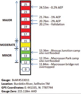
When BoM flood warnings are issued for a flood warning river height station, the severity of flooding is
described as minor, moderate or major—according to the effects caused in the local area or in nearby
downstream areas. The BoM may also make quantitative forecasts (for example, the specific height at a gauge)
and flood mapping relative to a particular gauge height can be particularly beneficial.
Flood classifications
Minor flooding: Causes inconvenience. Low-lying areas next
to watercourses are inundated. Minor roads may be closed
and low-level bridges submerged. In urban areas inundation
may affect some backyards and buildings below the floor
level as well as bicycle and pedestrian paths. In rural areas
removal of stock and equipment may be required.
Moderate flooding: In addition to the above, the area of
inundation is more substantial. Main traffic routes may be
affected. Some buildings may be affected above the floor
level. Evacuation of flood-affected areas may be required.
In rural areas removal of stock is required.
Major flooding: In addition to the above, extensive rural
areas and/or urban areas are inundated. Many buildings
may be affected above the floor level. Properties and towns
are likely to be isolated and major rail and traffic routes
closed. Evacuation of flood-affected areas may be required.
Utility services may be impacted.
Discussion with floodplain residents also shows they are confused and frustrated by the
use of terms such as minor, moderate and major flooding. By themselves, these terms and
their formal definitions are not well understood in the community, and they are vague and
often unhelpful. They therefore are not persuasive on their own as descriptors of flood
severity. (Flood Warning, Manual 21, Australian Emergency Manuals Series, Page 43)
The challenge for local government and local disaster management groups is to ensure the flood warnings
they issue contain the information needed by their community at large and those potentially impacted—both
directly and indirectly.
22 | Queensland Flood Mapping Program | October 2014 |Benefits | Why are flood maps important?
Flood maps provide a practical tool for determining the likely consequences of an alerted flood event,
especially when the flood map is related to a gauge height.
Whilst every flood event is different, community members want information they can use to determine what
actions they need to take to limit the impact of a flood event. It is practical information about the consequences
that allow this to happen (e.g. bridge not accessible or flooding on certain streets etcetera).
Where available, flood simulations/animations also provide a visual representation of the sequence of
inundation which can be useful in prioritising what needs to done and when it needs to be done by.
Useful information
1. Best practice involves investing time in consulting with the community regarding warning content
(the message) and when and how it should be delivered (the mechanisms and time to ensure
adequate time to respond).
The options available to issue warnings are quite extensive and include SMS, via phone, email,
door-knocks and social media. What constitutes the right mix for a community is determined by that
community’s needs relating to timing, available resources and even physical constraints.
2. Importantly, best practice involves reviewing the warning system from time to time to ensure
distribution methods being employed remain the best options–considering the risk flooding presents
and the typical time between rain events and eventual flooding, which can vary from hours to days or
even weeks.
3. The QDMA includes specific guidelines in relation to emergency alerts and the standard emergency
warning signal. LDMGs should consult these guides when developing their public information and
warnings sub-plan.
The Queensland Emergency Alert Guidelines and Guidelines for the Standard Emergency Warning
Signal (SEWS) and its use in Queensland are available at www.disaster.qld.gov.au/Disaster-Resources/
Documents/Queensland%20Emergency%20Alert%20Guidelines.pdf.
Case study: MoretonAlert – a council disaster communication system (Moreton Bay)
MoretonAlert provides warnings about severe weather, possible major dam releases and flash flooding events within the
region. The system complements existing warning mechanisms. The BoM issues weather warnings via the radio. These weather
warnings are a good source of information and can provide valuable advice about weather conditions. The state government
also operates an emergency alert system which may also issue messages to residents during emergency situations.
MoretonAlert is a unique council initiative that enables residents to also share their flood information. Council encourages the
community to share their local flood data, including photos and evidence of major flood events in the region, allowing council
to verify and improve flood predictions and improve the safety of their floodplains.
Read more: MoretonAlert https://www.moretonbay.qld.gov.au/moretonalert.aspx
| Queensland Flood Mapping Program | October 2014 | 23Element 2: Public information
Introduction | Why is this important?
Public information during flood response operations is provided for the advice of those affected and for the
public generally. It will include information previously disseminated via community awareness and education
programs, however it is important to recognise that during a flood people may not be able to locate previously
provided information.
In addition to the issuing of flood warnings, the range of specific issues on which the community at risk
should be advised includes, as appropriate to the flood conditions:
• instructions on evacuation, including an emergency kit;
• road closures;
• public health;
• maintenance of essential services and utilities;
• security of evacuated areas;
• damage minimisation;
• how to obtain assistance;
• immediate welfare and recovery arrangements; and
• means of cleaning up as the flood recedes.
Flood mapping outputs will assist in determining specific areas of interest such as road closures, water depth
and velocity of water over property and evacuation plans.
Case study: Consistent information for councils through DisasterHub (LGAQ)
Developed and maintained by the Local Government Association of Queensland (with Resolute IT), the DisasterHub is
available through councils websites and provides a consistent set of tools and information to assist in preparation before
and response during disaster events. It enables emergency communication through a central location, ensuring that council’s
website is the first point of contact for disaster-related issues.
DisasterHub also provides access to specialist information, including factsheets and guidelines, developed by various
state government agencies and other organisations. It has been developed to ensure a sustainable approach for the
delivery of information in disaster situations, and provides an innovative interaction point between the community and
councils. It aims to reduce the vulnerability of local communities by externally hosting the tools and information away
from possible centres of disaster.
The information covers all relevant natural hazards that may occur within the state, and focus on residential and business
related information. It provides common content to all councils and allows for council-specific content to be tailored to the
local catchment area.
Read more: DisasterHub http://www.disasterhub.com.au/
24 | Queensland Flood Mapping Program | October 2014 |Element 3: Evacuation and supplies
Introduction | Why is this important?
The evacuation of people at risk may be required for reasons of safety and potential isolation. In addition
communities and/or properties can become isolated in the event of a flood. If flood predictions provide
sufficient time for stocking up on items prior to the isolation, this measure can provide a better level of
resilience to the flood than would otherwise be attained. If not, the safe re-supply or evacuation are important
parts of any flood response and crucial for recover.
Benefits | Why are flood maps important?
Flood mapping outputs can assist in determining those at risk to either of these categories, the timing of
required evacuation and the best location of the evacuation centres.
Flood mapping studies may help in determining when resupply can occur due to transport routes—rail,
road or air—being safely reopened to specified transport.
Useful information
A checklist to assist Disaster Operation Controllers co-ordinate resupply activities provided in Annex A of
Flood Response Manual 22 of the Australian Emergency Manual Series.
Download a copy from http://www.em.gov.au/Documents/Manual%2022-Flood%20Response(2).PDF
Element 4: Property protection
Introduction | Why is this important?
The protection of private property is an important focus during floods, but it will normally be given a
lower management priority than the protection of life and the protection of critical infrastructure. In some
circumstances the role of agencies in property protection may be limited to the provision of advice to the
owners and occupiers of property. The general aim of property protection is to prevent or minimise property
damage and there are two general methods of prevention. The first is simply the lifting of items above the
predicted peak or the temporary removal and the second is the building of temporary barriers.
Benefits | Why are flood maps important?
Flood study output can help identify what property is at risk and the potential timing of the inundation. This
may help in the development of the appropriate strategies to minimise property damage.
Case study: An urban risk assessment framework (World Bank)
The World Bank, with UN-Habitat, UNEP and Cities Alliance, has developed an urban risk assessment (URA) framework based
on experiences in many cities. The URA offers a flexible approach that project and city managers can use to identify feasible
measures to assess a city’s risk. The methodology focuses on three reinforcing pillars that collectively help to understand
urban risk: a hazard impact assessment, an institutional assessment, and a socioeconomic assessment.
The assessment is based on four principal building blocks to improve the understanding of urban risk: historical incidence
of hazards, geospatial data, institutional mapping and community participation. The URA is flexible in how it is applied,
depending on available resources and institutional capacity in a given city.
Read more: http://go.worldbank.org/VW5ZBJBHA0
| Queensland Flood Mapping Program | October 2014 | 25You can also read