Implementation Procedures for the Agricultural System in Ontario's Greater Golden Horseshoe - Supplementary Direction to A Place to Grow: Growth ...
←
→
Page content transcription
If your browser does not render page correctly, please read the page content below
Implementation
Procedures for the Agricultural
System in Ontario’s Greater
Golden Horseshoe
Supplementary Direction to A Place to Grow:
Growth Plan for the Greater Golden Horseshoe
Publication 856
IMPLEMENTATION
PROCEDURES
for the Agricultural System in
Ontario’s Greater Golden Horseshoe
March 2020
These implementation procedures and the accompanying mapping for the
Agricultural System are Supplementary Direction to A Place to Grow: Growth Plan for the
Greater Golden Horseshoe, 2019. They were issued by the Province in March 2020 and
take effect immediately.
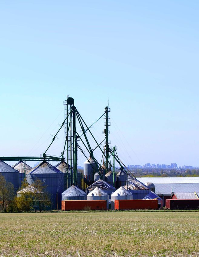
Ontario Ministry of Agriculture, Food and Rural AffairsDesign Editor Arlene Robertson, Ontario Ministry of Agriculture, Food and Rural Affairs (OMAFRA) Content Editor Karen Carruthers, OMAFRA Authors Helma Geerts, MSc, MCIP, RPP, OMAFRA Arthur Churchyard, MSc, MCIP, RPP, OMAFRA Contributor: Carolyn Puterbough, B.Sc. (Agr), OMAFRA Need technical or business information? Contact the Agricultural Information Contact Centre at 1-877-424-1300 or ag.info.omafra@ontario.ca A complete listing of all OMAFRA products and services are available at www.ontario.ca/omafra To obtain digital and/or print copies of OMAFRA publications, please order: • Online at www.serviceontario.ca/publications • By phone through the ServiceOntario Contact Centre Monday to Friday, 8:30 AM to 5:00 PM • 416-326-5300 • 416-325-3408 (TTY) • 1-800-668-9938 Toll-free across Canada • 1-800-268-7095 TTY Toll-free across Ontario Disclaimer This document is for informational purposes only. It is intended to serve as a guide and not as expert advice. Published by the Ministry of Agriculture, Food and Rural Affairs © Queen’s Printer for Ontario, 2020 Toronto, Canada ISBN 978-1-4868-4260-5 (Print) ISBN 978-1-4868-4261-2 (PDF) Disponible en français Cover Photo credits Grain elevators and railway line – Ontario Ministry of Municipal Affairs and Housing, 2016
Table of Contents
Summary                                                                                                      v
Part A: Context                                                           1
1       An Agricultural System in Ontario’s Greater Golden Horseshoe Area 3
       1.1 Introduction                                                             3
       1.2 The Significance of the Agri-Food Sector                                 3
       1.3 Evolution of the Agricultural System Concept                             6
       1.4 Purpose and Outcomes                                                     7
       1.5 Effect of the Implementation Procedures and Provincial Planning Context 8
           1.5.1       A Place to Grow and Greenbelt Plan                           9
           1.5.2       Oak Ridges Moraine Conservation Plan                        13
           1.5.3       Niagara Escarpment Plan                                     13
       1.6 Innovations in the Agricultural System Approach                         14
2      Provincial Identification of the Agricultural System                                                 17
       2.1 Agricultural Land Base Methodology                                                               17
           2.1.1      Prime Agricultural Areas                                                              18
           2.1.2      Candidate Areas for the Agricultural Land Base                                        19
           2.1.3      Interactions Between the Natural Heritage System,
                      the Water Resource System and the Agricultural Land Base                              19
       2.2 Agri-Food Network                                                                                21
           2.2.1      Network Elements                                                                      21
           2.2.2      Data Sources                                                                          23
           2.2.3      Uses of Agri-Food Network Information                                                 25

Part B: Implementation Procedures                                                                           27
3       Implementation of Agricultural System Policies                                                      29
       3.1 Official Plan Review                                                                             29
       3.2 Status of Agricultural Land Base Mapping                                                         30
       3.3 Agricultural Land Base Refinements                                                               31
           3.3.1       Timing and Approval of Refinements                                                   31
           3.3.2       Municipal Refinement Process                                                         33
           3.3.3       Official Plan Designations                                                           44
           3.3.4       Official Plan Policies                                                               45
           3.3.5       Updates to the Provincial Agricultural Land Base Map                                 46
       3.4 Toolbox for Implementing the Agricultural System                                                 46
           3.4.1       Considering Agri-Food Impacts when
                       Municipal Decisions are Made                                                         47
           3.4.2       Agriculture Economic Development                                                     47
       3.5 Performance Monitoring                                                                           53
       3.6 Beyond the Greater Golden Horseshoe                                                              54

              Implementation Procedures for the Agricultural System in Ontario’s Greater Golden Horseshoe        iii
4 Appendices 55
Appendix 1. Summary of Key References and Policies in the Four Plans 55
Appendix 2. OMAFRA’s Land Evaluation and Area Review (LEAR)
for the Greater Golden Horseshoe 59
5 References 63
Figures
Figure 1. The Greater Golden Horseshoe 4
Figure 2. Conventional vs. Agricultural System Approach
(outside of the Greenbelt) 14
Figure 3. Example of an Agri-Food Value Chain 24
Figure 4. Example Map with Selected Mapping Layers from the
Agricultural System Portal 25
Figure 5. Agricultural Land Base Map Refinement 35
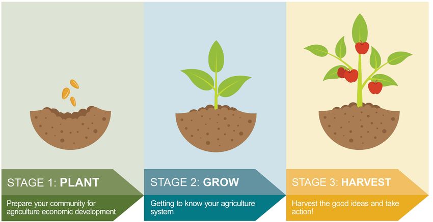
Figure 6. Three Stages of Agriculture Economic Development 48
Figure 7. Matching Activities with Community Capacity 51
iv Implementation Procedures for the Agricultural System in Ontario’s Greater Golden HorseshoeSummary
This document replaces the original Implementation Procedures for the Agricultural
System in the Greater Golden Horseshoe (February 2018). It has been updated to align
with A Place to Grow: Growth Plan for the Greater Golden Horseshoe, 2019.
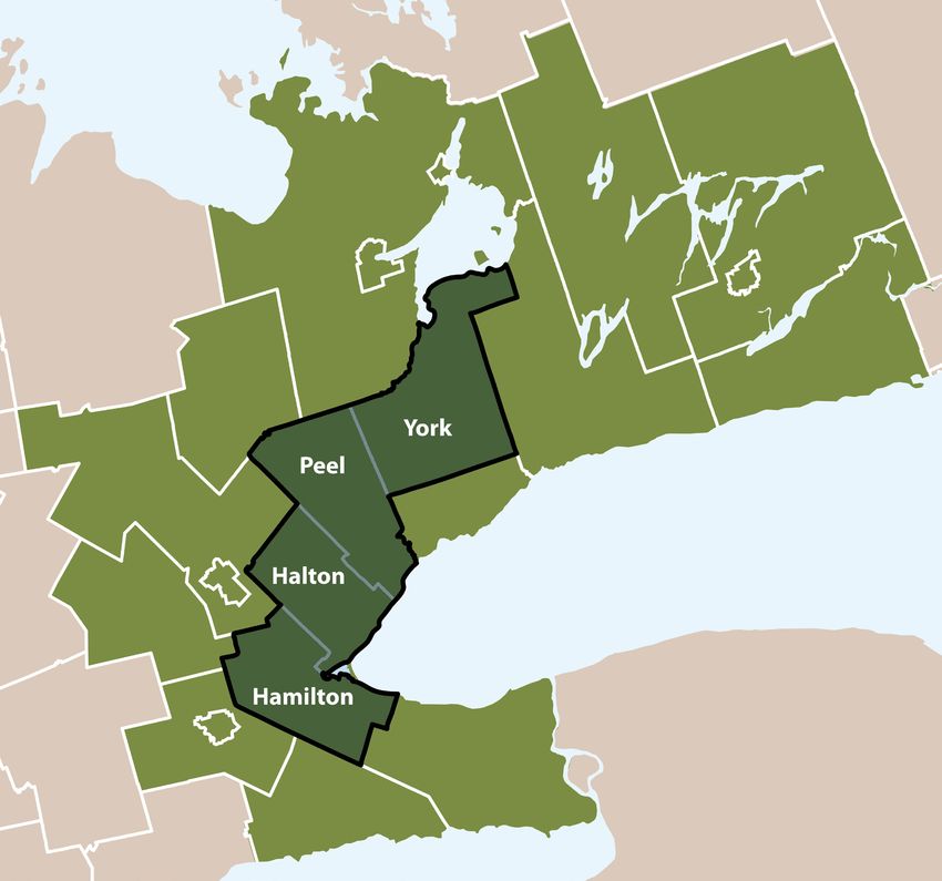
Ontario’s Greater Golden Horseshoe (GGH)1 is one of the most dynamic and fastest growing
regions in North America and is the economic engine of Ontario. It contains a large agri‑food
cluster and Canada’s most diverse and productive agricultural area. The agri-food cluster is a
key economic driver, providing one in eight jobs. The GGH comprises only 3.5% of Ontario’s
land base but contains 70% of its population and 42% of the province’s best (Class 1)
agricultural land, based on the Canada Land Inventory (CLI)2.
The Province is committed to making rural Ontario and Ontario’s agri-food sector open for
business, investment and jobs. The agri-food sector is a significant economic contributor,
poised for growth.
Ontario is taking an innovative approach to planning for agriculture across the GGH,
referred to throughout this document as the “Agricultural System approach.” This
approach recognizes that farmland and clusters of agri-food infrastructure, services
and assets need to coexist and be compatible with rapidly growing communities. To be
successful, deliberate and strategic planning should address the needs of the agri-food
sector so it can grow and prosper.
This document is focused on the geographic areas covered by A Place to Grow: Growth
Plan for the Greater Golden Horseshoe and the Greenbelt Plan.
Implementation of the Agricultural System approach requires cooperation between land
use planners, economic developers, different levels of government, communities and
the agri-food sector. Given the significance of the agri-food sector, it should be a priority
for economic development and a major consideration when infrastructure, services and
programs are planned.
The Agricultural System approach will improve farmland protection while creating the
conditions under which the agri-food sector can prosper. The agricultural land base is
comprised of prime agricultural areas, including specialty crop areas and rural lands
where farming and related uses are ongoing. While the Province and municipalities have
traditionally focused on protection of prime agricultural areas, the Agricultural System
approach also recognizes that rural lands used for agriculture help create a continuous
land base for agriculture, link prime agricultural areas and may support elements of the
agri-food network.
1
Words in italics are defined in the Provincial Policy Statement, A Place to Grow: Growth Plan for the Greater Golden Horseshoe,
Greenbelt Plan, Oak Ridges Moraine Conservation Plan and/or the Niagara Escarpment Plan.
2
CLI is an interpretative system for assessing the effects of climate and soil characteristics on the limitations of land for growing
common field crops.
Implementation Procedures for the Agricultural System in Ontario’s Greater Golden Horseshoe vSummary
The Province has issued the agricultural land base map for the GGH. This map may be
refined by municipalities in conjunction with the Ontario Ministry of Agriculture, Food
and Rural Affairs (OMAFRA) and the Ministry of Municipal Affairs and Housing (MMAH) in
advance of or as part of a municipal comprehensive review. Municipalities have important
roles to play to support and plan for the agri-food sector.
In addition, OMAFRA’s web-based tool, the Agricultural System Portal, includes a series
of maps detailing the agri-food network that may be used by municipalities and others
to advance economic opportunities for the agri-food sector. The portal maps can also
inform and enable assessment of potential adverse impacts of new development on
the Agricultural System. Impacts must be avoided, or where avoidance is not possible,
minimized and mitigated.
This document explains the Agricultural System approach and describes the agricultural
land base and the agri-food network. It provides implementation procedures for the
Agricultural System to guide municipal refinement of the agricultural land base map and
the integration of land use planning and economic development to achieve Agricultural
System objectives.
The Agricultural System approach builds on traditional approaches to agricultural land
use planning and economic development, and links the two to more holistically consider
agricultural viability.
Steps to Implement an Agricultural System in the Greater Golden Horseshoe
vi Implementation Procedures for the Agricultural System in Ontario’s Greater Golden HorseshoePart A: Context
1              An Agricultural System in Ontario’s
               Greater Golden Horseshoe Area
1.1            Introduction
This document will help municipalities, farmers and others interpret and implement the
Agricultural System references and policies in the four land use plans for the Greater
Golden Horseshoe (GGH) — A Place to Grow: Growth Plan for the Greater Golden
Horseshoe (A Place to Grow), Greenbelt Plan, Oak Ridges Moraine Conservation Plan and
Niagara Escarpment Plan.
This document focuses on the entire GGH (Figure 1). While the Niagara Escarpment Plan
Area extends beyond the GGH, only that portion in the GGH is addressed. This document
recognizes that linkages to the Agricultural System extend outside of the GGH.
This document explains:
    •   the Agricultural System concept, including its purpose and desired outcomes
    •   OMAFRA’s approach to identifying the agricultural land base for the GGH and the
        process for municipal refinements
    •   the role of the agri-food network in the Agricultural System and
    •   how municipalities and others can support a thriving agri-food sector through
        integrated land use planning and economic development.
Agriculture and food are central to Ontarians’ quality of life, economic prosperity, health,
environment, cultural expression and heritage. Effective farmland protection and a
thriving agri-food sector are integral to these values and priorities.

1.2            The Significance of the Agri-Food Sector
Ontario’s GGH is one of the fastest growing regions in North America, containing a
significant agri-food cluster and Canada’s most diverse and productive agricultural area.
With a climate moderated by proximity to the Great Lakes, fertile soils, and access to value
chains and major markets, the GGH supports a diverse and dynamic agri-food sector, one
of the GGH’s most significant economic drivers.
The agri-food sector accounts for approximately one in eight jobs in Ontario. There is global
and local demand for safe, sustainable, nutritious food, other agricultural products and
demand is rapidly growing. Awareness of the sector’s significance to the economy and quality
of life may help decision-makers and citizens embrace the Agricultural System concept.

                 Implementation Procedures for the Agricultural System in Ontario’s Greater Golden Horseshoe   3
An Agricultural System in Ontario’s Greater Golden Horseshoe Area
Figure 1. The Greater Golden Horseshoe (Source: Government of Ontario, 2019)
4 Implementation Procedures for the Agricultural System in Ontario’s Greater Golden HorseshoeAn Agricultural System in Ontario’s Greater Golden Horseshoe Area
Ontario’s thriving agri-food sector:
• creates jobs in rural and urban areas
• contributes to a diverse and stable municipal tax base
• stimulates the cultural vitality of rural communities
• supports essential rural and environmental services
• builds rural character and conserves cultural heritage resources
• produces more than 200 agricultural commodities (the most diverse
agricultural area in Canada) with associated market and business
opportunities and
• makes locally grown food available.
The GGH comprises only 3.5% of Ontario’s land area, but contains 42% of the province’s
best (Canada Land Inventory Class 1) farmland (OMAFRA, 2015). High quality farmland
is the foundation of the sector. Current and future generations depend on it to supply
food, fibre, fur and other bio-feedstock, support a thriving agri-food sector and rural
communities, provide habitat and many other valued amenities and adapt to a changing
climate. Good quality soil and water are under significant pressure and must be protected
to enable local food production, agri-food exports and the growing bioeconomy, and
significantly contribute to jobs and economic prosperity in Ontario.
While there are some market advantages that come with the concentration of the agri-
food sector in a densely populated area, pressure to fragment and convert the prime
agricultural area to non-agricultural uses is strong and ongoing. Managing growth while
protecting valuable resources, including agriculture, is at the heart of A Place to Grow and
the Greenbelt Plan.
The Census of Agriculture indicated that between 2001 and 2016, the area reported to be
in agriculture fell by more than ten per cent in the GGH, an area of approximately 170,00
hectares or 420,000 acres (Statistics Canada, 2001 and 2016). Over the past 15 years, an
area more than two and a half times the size of the City of Toronto is no longer reported
to be in agriculture.
Even so, over 40% of the GGH remains available for agriculture today3 (OMAFRA, 2018).
Implementation of the Agricultural System will help to ensure this remaining farmland is
better protected and is viable over the long term. A Place to Grow directs growth to built-up
areas and to be compact in greenfield areas.
3
Estimated by OMAFRA using data from the Municipal Property Assessment Corporation and Southern Ontario Land Resource
Information System.
Implementation Procedures for the Agricultural System in Ontario’s Greater Golden Horseshoe 5An Agricultural System in Ontario’s Greater Golden Horseshoe Area
1.3 Evolution of the Agricultural
System Concept
Over the past 40 years, efforts were made to integrate land use planning and economic
development to support the agri-food sector. In 1976, A Strategy for Ontario Farmland
declared the Province’s commitment to maintaining a permanent, secure and
economically viable agricultural industry, not only as a producer of food, but as an
important component of the economic base, a source of employment, and the basis of
the rural community and the rural way of life (Government of Ontario, 1976). The strategy
included measures to ensure that better agricultural land was protected and programs
were in place to support the economic feasibility of agriculture. The Food Land Guidelines
(1978) and the PPS (1997, 2005 and 2014) followed, with a focus on ensuring the land
base was protected for agriculture. To also address agricultural viability, a more integrated
approach extending beyond land use planning is required.
In 2005, the Greenbelt Plan first used the agricultural system terminology. It referred to
the agricultural system as a continuous and permanent land base necessary to support
long-term agricultural production and economic activity. Around the same time as the
Greenbelt was established, the Greater Toronto Area (GTA) Agricultural Action Committee
was formed, bringing the local Federations of Agriculture together with municipal land use
planners and economic developers to develop an action plan for a thriving and integrated
food and farming cluster in the GTA. In 2012, this evolved to a more encompassing Golden
Horseshoe Food and Farming Action Plan 2021, led by an expanded Golden Horseshoe
Food and Farming Alliance (GHFFA). The GHFFA, with the help of member municipalities
and OMAFRA, produced agri-food asset mapping for the agri-food value chain, including
infrastructure, services and other assets the sector depends on.
In 2015, the Friends of the Greenbelt Foundation commissioned a study, The Agricultural
System: Components, Linkages, and Rationale, to explore the agricultural system concept
(Caldwell, 2015). Later that year, the Ontario Federation of Agriculture (OFA) and
Environmental Defence, again with the help of the Friends of the Greenbelt Foundation,
produced the report, Farmland at Risk: Why Land-use Planning Needs Improvements
for a Healthy Agricultural Future in the Greater Golden Horseshoe (Ontario Federation
of Agriculture and Environmental Defense, 2015). It discussed the need for Ontario to
do a better job of protecting farmland and helping farmers thrive in the GGH. Further, it
recommended that the Province identify and map an agricultural system for the GGH,
including a productive land base and the full range of inputs and outputs from agriculture.
6 Implementation Procedures for the Agricultural System in Ontario’s Greater Golden HorseshoeAn Agricultural System in Ontario’s Greater Golden Horseshoe Area
The Golden Horseshoe Food and Farming Alliance, with the support of 21
municipalities and OMAFRA, created robust agri-food asset mapping for the
GGH, under the banner ConnectON. By combining many data sources and using
Geographic Information Systems, they produced a database and mapping to
help identify the strengths and weaknesses of existing agri-food assets, gaps and
new opportunities. This is one of the data sources used in OMAFRA’s Agricultural
System Portal. See Section 2.2.2 for more detail.
The ten-year review of the Growth Plan and Greenbelt Plan resulted in new Agricultural
System policies and definitions incorporated into the provincial plans in 2017. Then in 2019,
an update to the Growth Plan resulted in more flexible Agricultural System policies in A Place
to Grow. As a result, these implementation procedures were developed as a Supplementary
Direction to A Place to Grow.
In addition to these provincial initiatives within the GGH and Greenbelt, municipalities
have completed agricultural economic impact studies and have developed agricultural
action plans that address both land use and economic development. Examples include
Niagara Region (PlanScape, 2010), Northumberland (County of Northumberland, 2008)
and Wellington County (Millier, Dickinson and Blais, 2012).
Over the years, agricultural stakeholders also suggested that a systems approach be
applied to agriculture, like that used for natural heritage. They suggested treating
agriculture, natural heritage and water equitably and emphasized the need to recognize
the synergies and overlapping geographies of these systems.
Together, the Agricultural System references and policies in the provincial plans, these
implementation procedures, OMAFRA’s agricultural land base map, and the agri-food
mapping portal provide a framework to protect farmland, while supporting the viability of
the agri-food sector.
1.4 Purpose and Outcomes
As noted, the 2005 Greenbelt Plan put forward the notion of an agricultural system
focused on the land base for agriculture. The updated plans takes a more holistic approach,
expanding the focus beyond farmland protection to include measures that help create the
conditions under which the agri-food sector can prosper. Applying an Agricultural System
approach recognizes the importance of the agri-food sector to regional and provincial
economies. It recognizes infrastructure, services and agri-food assets along the value chain
that the agri-food sector needs to thrive. Municipalities, economic developers, land use
planners, farmers, agri-food businesses, and the Province can reinforce and advance the
GGH’s position as one of North America’s most significant agri-food clusters.
Implementation Procedures for the Agricultural System in Ontario’s Greater Golden Horseshoe 7An Agricultural System in Ontario’s Greater Golden Horseshoe Area
The desired outcomes of the Agricultural System approach are:
1. Active planning for agriculture and rural economic development based on reliable
mapping, data and tools.
2. Improved viability of agriculture and growth of the agri-food sector.
3. Better protection of the agricultural land base.
4. Increased land use planning consistency and certainty across municipalities.
5. Reinforcement of the synergies between agricultural, natural heritage and water
systems, as outlined in provincial policy.
6. Collaboration between the Province, municipalities, farmers and businesses with a
common interest in a strong agri-food sector.
1.5 Effect of the Implementation Procedures and
Provincial Planning Context
The implementation procedures presented in Part B of this document are meant to
complement and explain the intent of Agricultural System references and policies in A Place to
Grow, Greenbelt Plan, Niagara Escarpment Plan and Oak Ridges Moraine Conservation Plan.
The GGH land use plans build upon the policy foundation provided by the PPS. As such, they
should be read in conjunction with the PPS. The policies of the GGH plans take precedence
over the policies of the PPS to the extent of any conflict, except where the relevant law
provides otherwise. Provincial guidelines help planning authorities interpret provincial policy
and reduce variability in protection. These Agricultural System implementation procedures
are intended to serve the purpose of provincial guidelines for designating prime agricultural
areas in the GGH and may provide insights for areas beyond the GGH.
A Place to Grow states that the Province will identify, establish or update the Agricultural
System for the GGH as Supplementary Direction (policy 5.2.2.2). These implementation
procedures and accompanying mapping are the Supplementary Direction referred to in
A Place to Grow. In the area under A Place to Grow, municipalities may refine provincial
mapping in a manner that conforms with the A Place to Grow policies and these
implementation procedures (A Place to Grow policy 4.2.6.9). Provincial mapping only applies
after it has been incorporated into an approved upper- or single-tier official plan. In contrast,
in the Greenbelt area, the provincial agricultural land base mapping applies immediately.
However, municipalities are required to refine and augment their official plan mapping to
bring it into conformity with provincial mapping and these implementation procedures.
Under both A Place to Grow and the Greenbelt Plan, prime agricultural areas must
be identified as directed in these implementation procedures to consistently protect
and achieve geographic continuity of the agricultural land base. These implementation
procedures also identify elements of the agri-food network and recommend how to
maintain and enhance functional connections within the network, as required by A Place
to Grow policy 4.2.6.4 and Greenbelt Plan policy 3.1.2.6.
8 Implementation Procedures for the Agricultural System in Ontario’s Greater Golden HorseshoeAn Agricultural System in Ontario’s Greater Golden Horseshoe Area
The Agricultural System approach also links to provincial initiatives related to
environmental protection, climate change adaptation and mitigation, soil health and water
quality to meet societal, economic and environmental needs.
The GGH is covered by a number of treaties that provide for treaty rights. Indigenous
communities may have Aboriginal rights in this area. OMAFRA recognizes the role that
Indigenous peoples have in the growth and development of this region. Provincial policy
will be implemented in a manner that is consistent with the recognition and affirmation of
existing Aboriginal and treaty rights under Section 35 of the Constitution Act, 1982.
The subsections below briefly summarize provincial plan policies that pertain to the
Agricultural System. Appendix 1 lists provincial plan policy references under main topics
related to the Agricultural System. Refer to the actual provincial land use plans for the full
set of policies and definitions. The plans should be read in their entirety and in conjunction
with all other applicable land use planning policy and law.
Agricultural System – The system mapped and issued by the Province in accordance
with this Plan, comprised of a group of inter-connected elements that collectively
create a viable, thriving agricultural sector. It has two components:
1. An agricultural land base comprised of prime agricultural areas, including
specialty crop areas, and rural lands that together create a continuous
productive land base for agriculture;
2. An agri-food network which includes infrastructure, services and assets
important to the viability of the agri-food sector.
Agri-Food Network – Within the Agricultural System, a network that includes elements
important to the viability of the agri-food sector such as regional infrastructure; on-
farm buildings and infrastructure; agricultural services, farm markets, distributors, and
primary processing; and vibrant, agriculture-supportive communities.
A Place to Grow
1.5.1 A Place to Grow and Greenbelt Plan
A Place to Grow addresses growth management, and both A Place to Grow and the
Greenbelt Plan contain policies on protecting the Agricultural System and natural heritage
systems. The two plans have similar policies that relate to agriculture and the Agricultural
System by:
• specifying that the provincially-identified agricultural land base includes a continuous
land base comprised of prime agricultural areas, including specialty crop areas and
rural lands, as well as a complementary agri-food network that supports long-term
agricultural production and the economic viability of the agri‑food sector.
Implementation Procedures for the Agricultural System in Ontario’s Greater Golden Horseshoe 9An Agricultural System in Ontario’s Greater Golden Horseshoe Area
• allowing for mapping refinements. However, the plans differ on when provincial
mapping applies, as discussed in these implementation procedures.
• requiring municipalities to designate prime agricultural areas, including specialty
crop areas, in accordance with mapping and implementation procedures issued by
the Province, and protect these areas for long-term use for agriculture.
• requiring municipalities to maintain and enhance the functional and economic
connections to the agri-food network. Unlike prime agricultural areas, the
agri‑food network is not a land use designation within an official plan.
• indicating in A Place to Grow that upper- and single-tier municipalities, in advance of
or as part of their municipal comprehensive review, may consider a settlement area
boundary expansion if certain conditions are met. Prime agricultural areas are to be
avoided where possible through the evaluation of alternatives across the upper- and
single-tier municipality based on avoiding, minimizing and mitigating impacts on the
Agricultural System (A Place to Grow policy 2.2.8.3 f). Adverse impacts on the agri-
food network, including agricultural operations, from expanding settlement areas are
to be avoided, or if avoidance is not possible, minimized and mitigated as determined
though an Agricultural Impact Assessment (AIA)4 (A Place to Grow policy 2.2.8.3 h).
• requiring AIAs or equivalent analysis as part of an environmental assessment for
infrastructure projects (e.g., planned corridors) that cross prime agricultural areas
to avoid or, if avoidance is not possible, minimize and mitigate impacts to the
extent feasible.
• requiring applications for new mineral aggregate operations within prime
agricultural areas to be supported by an AIA and, where possible, to maintain or
improve connectivity of the Agricultural System.
• requiring that land use compatibility be achieved, in particular in areas where
agricultural uses and non-agricultural uses interface. Mitigation measures should
be incorporated within the area being developed. Where appropriate, this should
be based on an AIA.
• permitting a variety of uses in prime agricultural areas (agricultural,
agriculture‑related and on-farm diversified uses), aligned with the PPS and the
Guidelines on Permitted Uses in Prime Agricultural Areas (OMAFRA, 2016).
• requiring municipalities to implement strategies to support and enhance
the Agricultural System when undertaking integrated planning for growth
management, including goods movement and transportation planning.
• encouraging municipalities to support the long-term economic prosperity and
viability of the agri-food sector, for example, through:
◦ local food initiatives (e.g., food hubs)
◦ integration of agricultural economic development, infrastructure, goods
movement and freight considerations with land use planning
4
OMAFRA’s AIA guidance document provides additional detail. Other studies may also be required for proposed settlement area
boundary expansions, proposed infrastructure, applications for mineral aggregate operations and other proposed non-agricultural uses.
10 Implementation Procedures for the Agricultural System in Ontario’s Greater Golden HorseshoeAn Agricultural System in Ontario’s Greater Golden Horseshoe Area
◦ preparing regional agri-food and economic development strategies
◦ engaging with local farmers and agri-food experts (e.g., through agricultural
advisory committees and liaison officers) and
◦ providing outreach and education opportunities.
The Greenbelt Plan aims to protect the agricultural land base, as well as ecological and
hydrological features, areas and functions within the Greenbelt area. It states that the
Agricultural System, along with a Natural Heritage System, water resource system and
settlement areas, are part of the Protected Countryside. The Greenbelt Plan states that the
Natural Heritage System is an overlay5 on top of the prime agricultural area and rural lands
designations, not a separate, distinct designation. Likewise, A Place to Grow states that the
Natural Heritage System for the Growth Plan is an overlay outside of settlement areas.
A Place to Grow and Greenbelt Plan policies allow the full range of agricultural,
agriculture-related, on-farm diversified uses and normal farm practices in the Natural
Heritage System for the Growth Plan / Greenbelt Plan Natural Heritage System,
respectively, subject to key natural heritage feature and key hydrologic feature policy
tests outlined in Greenbelt Plan policy 3.2.5 and A Place to Grow policies 4.2.3 and 4.2.4.
The Greenbelt Plan requires that decisions on permitted uses be based on the provincial
Guidelines on Permitted Uses in Prime Agricultural Areas (OMAFRA, 2016).
More specifically, new agricultural uses that would involve development or site alteration
would not be permitted in key natural heritage features within the Natural Heritage
System for the Growth Plan or Greenbelt Natural Heritage System and key hydrologic
features (A Place to Grow policy 4.2.3.1 and Greenbelt Plan policy 3.2.5.1). However,
expansions or alterations to existing agricultural buildings may be permitted, subject to
the criteria outlined in A Place to Grow policy 4.2.3.1 and Greenbelt Plan policy 4.5.5
(e.g., the expansion is directed away from the feature to the maximum extent possible).
Activities not involving approval under the Planning Act may also be permitted (e.g.,
agro‑forestry and maple syrup production) subject to other approvals, if required.
For development or site alteration within 120 metres of a key natural heritage features
within the Natural Heritage System for the Growth Plan or Greenbelt Natural Heritage
System and key hydrologic features, new agricultural buildings will be required to
undertake a natural heritage or hydrologic evaluation, unless a minimum 30 metre6
vegetation protection zone (i.e., buffer) is provided from the feature (A Place to Grow
policy 4.2.4.4 and Greenbelt Plan policy 3.2.5.7).
5
An overlay is applied overtop of a certain geographic area already designated within an official plan. The intent of an overlay is to
apply additional regulations on development in the overlay area. The conditions imposed by an overlay are in addition to, and not in
lieu of, the permissions or restrictions associated with any underlying designation.
6
In the Niagara Peninsula Tender Fruit and Grape Area, new buildings or structures for agricultural, agriculture-related and on-farm
diversified uses are permitted within 30 metres of a permanent or intermittent stream if the stream also functions as an agricultural
swale, roadside ditch or municipal drain, as determined through provincially-approved mapping and a minimum 15 metre vegetation
protection zone is established. (See Greenbelt Policy 3.2.5.8)
Implementation Procedures for the Agricultural System in Ontario’s Greater Golden Horseshoe 11An Agricultural System in Ontario’s Greater Golden Horseshoe Area
Where natural heritage features and areas are located outside of the Natural Heritage
System for the Growth Plan or the Greenbelt Natural Heritage System, development or
site alteration is generally not permitted unless no negative impacts on the feature or
its functions can be demonstrated (PPS policy 2.1.5). However, agricultural uses may
continue, in accordance with the PPS.
The Province’s Infosheet on agriculture and natural heritage in the provincial plans
describes the connections between natural heritage and the Agricultural System in
the GGH, and provides an overview of the policies governing land uses in these areas.
Both the Greenbelt Plan and A Place to Grow recognize that farms within the Agricultural
System contain important natural heritage and hydrologic features and functions, as
well as water resource systems. With good stewardship, these farms can bring both
environmental benefits and agricultural protection.
The plans also identify the need to protect cultural heritage resources, including built
heritage resources, cultural heritage landscapes and archaeological resources. These
cultural heritage resources may be located on farms and/or agri-food operations.
“The GGH contains a broad array of important hydrologic and natural heritage
features and areas, a vibrant and diverse agricultural land base, irreplaceable
cultural heritage resources, and valuable renewable and non-renewable resources.
These lands, features and resources are essential for the long-term quality of life,
economic prosperity, environmental health and ecological integrity of the region.
They collectively provide essential ecosystem services, including water storage and
filtration, cleaner air and habitats, and support pollinators, carbon storage, adaptation
and resilience to climate change.
These valuable assets must be wisely protected and managed as part of planning
for future growth. This is of particular importance in the fast-growing GGH, which
supports some of the most diverse vegetation and wildlife in Canada, including
the Niagara Escarpment (a UNESCO World Biosphere Reserve) and the Oak Ridges
Moraine — two of Ontario’s most significant landforms...”
Section 4.1, A Place to Grow
12 Implementation Procedures for the Agricultural System in Ontario’s Greater Golden HorseshoeAn Agricultural System in Ontario’s Greater Golden Horseshoe Area
1.5.2 Oak Ridges Moraine Conservation Plan
This is an ecologically and hydrologically based plan that includes Agricultural System
references to better protect prime agricultural areas and recognize the infrastructure, services
and assets that support the viability of the agri-food sector. Prime agricultural areas are
frequently found within the Countryside Area designation but may also be located in Natural
Core Areas and Natural Linkage Areas. To implement the Oak Ridges Moraine Conservation
Plan, prime agricultural areas and rural lands within the agricultural land base should be
identified in accordance with the broader Agricultural System approach, recognizing both the
agricultural land base and agri-food network components. Linkages to the Agricultural System
outside of the Oak Ridges Moraine area should also be considered. The Oak Ridges Moraine
Conservation Plan also recognizes the moraine’s important cultural heritage resources, and
supports the identification, conservation, use and wise management of cultural heritage
resources to support the social, economic and cultural well-being of all communities.
Recognizing the cultural heritage value of agricultural areas supports the agricultural sector
and provides sustainable benefits to all communities.
1.5.3 Niagara Escarpment Plan
This is an ecologically based plan implemented by the Niagara Escarpment Commission
through a development control permit system in the plan area. This contrasts with the
other three GGH plans which are implemented through municipal official plans and zoning
by-laws. The approach to implementing the Agricultural System in the Niagara Escarpment
Plan Area is like that outlined for the Oak Ridges Moraine Conservation Plan. Within the
Niagara Escarpment Plan Area, prime agricultural areas are frequently found within the
Escarpment Rural Area designation, but portions of the Escarpment Natural Area and
Escarpment Protection Area designations may also have prime agricultural areas.
In both Escarpment Rural Areas and Escarpment Protection Areas, the protection and
maintenance of cultural heritage resources and their histories is identified as an objective
along with protection of agricultural lands. Like the other provincial plans, the recognition
of the cultural heritage value of agricultural areas can support the agricultural sector and
provide sustainable benefits to all communities.
In the context of implementing the Niagara Escarpment Plan, prime agricultural areas in
the Niagara Escarpment Plan Area should be identified in accordance with the broader
Agricultural System, recognizing both the agricultural land base and the agri-food network
components. Linkages to the Agricultural System outside of the Niagara Escarpment Plan
Area should also be considered (Niagara Escarpment Plan, Landscape Approach).
Implementation Procedures for the Agricultural System in Ontario’s Greater Golden Horseshoe 13An Agricultural System in Ontario’s Greater Golden Horseshoe Area
1.6 Innovations in the Agricultural
System Approach
The Agricultural System approach differs from conventional land use planning approaches
for agriculture in Ontario in a few key ways:
1. It aims for continuity of protection of prime agricultural areas across the GGH using
common nomenclature for land use designations.
2. It recognizes the important role of rural lands in agriculture and supporting
elements of the agri-food network.
3. It reinforces the need to integrate agricultural viability considerations with
farmland protection.
4. It recognizes overlaps and synergies between agriculture and natural heritage.
At this time, protection of agricultural land varies across the GGH. Similar land may be
designated prime agricultural area in one municipality and designated rural lands across
the municipal boundary, even when soils and other land use characteristics are comparable
(Figure 2). While all planning decisions must be consistent with the PPS and conform with
applicable provincial land use plans, there may be differences in policy interpretation
and application due to differing study methodologies and growth pressures from one
municipality to another.
Figure 2. Conventional vs. Agricultural System Approach (outside of the Greenbelt)
14 Implementation Procedures for the Agricultural System in Ontario’s Greater Golden HorseshoeAn Agricultural System in Ontario’s Greater Golden Horseshoe Area
Consistent mapping of the agricultural land base and use of common nomenclature are
needed to:
• ensure provincial agricultural resources are consistently protected for long- term
agricultural use across municipal boundaries.
• provide a strong basis for prime agricultural area and rural lands designations,
policies and planning decisions which impact agriculture.
• direct non-agricultural uses away from prime agricultural areas wherever possible.
• set a consistent approach to farmland protection across municipalities and land
use plans, avoid conflicting uses, and implement other measures to enhance
agricultural viability.
During consultations for the Coordinated Plan Review, many stakeholders expressed
the desire for additional assurance that farmland be protected over the long term.
Agricultural stakeholders, in particular, said they needed greater certainty that farmland
would remain in agriculture to make long-term business decisions.
Prime agricultural area: an area where prime agricultural lands predominate. This
includes areas of prime agricultural lands and associated Canada Land Inventory
Class 4 through 7 lands and additional areas where there is a local concentration of
farms which exhibit characteristics of ongoing agriculture. Prime agricultural areas
are to be identified by OMAFRA using guidelines developed by the Province as
amended from time to time.
Prime agricultural land: specialty crop areas and/or Canada Land Inventory Class 1,
2, and 3 lands, as amended from time to time, in this order of priority for protection.
A Place to Grow and Greenbelt Plan
Along with the goal of continuity of protection across the GGH, it is important to recognize
how prime agricultural areas are defined. Prime agricultural areas include specialty crop
areas, CLI Classes 1 to 3 lands and associated Classes 4 through 7 lands, and additional
areas with a local concentration of farms exhibiting characteristics of ongoing agriculture.
This is broader than prime agricultural lands (CLI Classes 1 to 3 lands) and may go beyond
the areas municipalities have already identified.
Implementation Procedures for the Agricultural System in Ontario’s Greater Golden Horseshoe 15An Agricultural System in Ontario’s Greater Golden Horseshoe Area
While protection of prime agricultural areas has been provincial policy since the 1970s,
the Agricultural System approach broadens the land protection concept by recognizing the
important role of rural lands in agricultural production and the agri-food network. Even if
rural lands do not include prime agricultural land (i.e., CLI Classes 1 to 3 land), these lands
are often used to grow crops or raise livestock and may link prime agricultural areas into
a continuous land base and/or support assets that are part of the agri-food network. In
essence, they are integral to a functional agricultural land base.
To consistently identify the agricultural land base across the GGH, the Province has mapped
the agricultural land base. The methodology OMAFRA used to do this is described in Section
2.1 and in the accompanying Agricultural System Mapping Method report (OMAFRA, 2018).
OMAFRA’s agricultural land base map may be refined by upper- and single-tier
municipalities before or during municipal comprehensive review based on additional
information and important local context (Section 3.2). The Province will support these
refinement efforts by sharing data and providing guidance. Refinements will be submitted
to the Province for review and approval.
A key focus of the Agricultural System approach is agricultural viability. To help support the
integration of agricultural viability with the agricultural land base, OMAFRA has mapped
elements of the agri-food network and identified a range of information and tools that
may be used to support the agri-food sector (Section 3.4). Municipalities and others can
use the mapping and tools to identify existing agri-food clusters and assess the potential
to develop new opportunities.
Additionally, the Greenbelt Plan and A Place to Grow recognize the linkage between
agriculture and natural heritage. By requiring the Natural Heritage System to be an overlay
and supporting connectivity of the systems across the landscape, the plans recognize their
complementary nature.
While commercial food production is a significant focus of the Agricultural System, the
Natural Heritage System supports traditional Indigenous food sources such as wild rice,
wild berries, wild leeks and game.
16 Implementation Procedures for the Agricultural System in Ontario’s Greater Golden Horseshoe2 Provincial Identification of the
Agricultural System
Provincial identification of the agricultural land base and the agri-food network is
summarized in this section.
Throughout the process, OMAFRA consulted with municipalities, experts and leaders
including economic developers, land use planners, farmers, agri-food businesses,
Indigenous communities and environmental groups.
Details on OMAFRA’s mapping method can be found in Appendix 2, with a more
in-depth explanation of the mapping methodology provided in the document,
Agricultural System Mapping Method (OMAFRA, 2018). This document is available
by request.
2.1 Agricultural Land Base Methodology
By its definition, the agricultural land base comprises prime agricultural areas, including
specialty crop areas, and rural lands that together create a continuous productive land
base for agriculture7. OMAFRA’s agricultural land base map identifies prime agricultural
areas and candidate areas for the agricultural land base. When municipalities undertake
refinements, these candidate areas may be added to prime agricultural areas or
designated rural lands. This is explained in the sections to follow.
In preparing the agricultural land base map for the GGH, the Province was guided by the
following principles:
• use of consistent, rigorous and transparent methods across the entire study area
• use of the best available information appropriate for regional-scale analysis as a
basis for land use designations and planning decisions and
• recognition of the overlap and synergies between the Natural Heritage System,
water resource systems and the Agricultural System and the need to protect and
maintain the health of all three systems.
7
In the Agricultural System definition, the word “agriculture” is intended to capture the full range of uses under the agricultural uses
definition (e.g., the growing of crops and raising of livestock).
Implementation Procedures for the Agricultural System in Ontario’s Greater Golden Horseshoe 17Provincial Identification of the Agricultural System
2.1.1 Prime Agricultural Areas
Prime agricultural areas are intended by provincial policy to incorporate areas where
prime agricultural lands (CLI Classes 1 to 3) predominate plus other associated Classes
4 to 7 lands and additional areas where there is a local concentration of farms with
characteristics of ongoing agriculture. OMAFRA identified the following as prime
agricultural areas for the purposes of its agricultural land base mapping:
1. Areas already designated as prime agricultural areas in approved official plans as
per the most up-to-date mapping available to OMAFRA.
2. Areas identified by OMAFFRA as meeting the definition of prime agricultural areas.
Certain lands were excluded from these areas, such as First Nation reserves, airports
regulated by the federal government, and large key natural heritage features described
below. The remaining land area comprised the prime agricultural areas layer in OMAFRA’s
agricultural land base map. Prime agricultural areas are a high priority for protection for
long-term use for agriculture.
While OMAFRA’s mapping is based on best available data and reasoned assumptions,
like all models, it may not capture exceptions or unique local circumstances. This prime
agricultural area mapping is intended to be reviewed and refined by municipalities based
on the methodology outlined in Section 3.3.
2.1.1.1 Existing Designated Prime Agricultural Areas
As noted, core elements of the agricultural land base include Provincially identified specialty
crop areas and prime agricultural areas designated in approved official plans.
Specialty Crop Areas
The PPS and other provincial plans require that specialty crop areas be given the highest
priority for protection of all prime agricultural areas. Specialty crop areas are areas where
crops are grown like tender fruit (e.g., peaches, cherries and plums), grapes, other fruit
crops, vegetable crops, greenhouse crops, and crops from agriculturally developed organic
soil. Usually a combination of suitable soil, climate, specialized production skills and capital
investments enable successful specialty crop production.
Specialty crop areas are unique and their significance is assessed based on factors such
as production diversity and concentration, agricultural investments, specific soil types,
microclimate, infrastructure, and economic significance (e.g., employment, tourism, agri-food
businesses, tax revenue).
The Greenbelt Plan recognizes and defines two specialty crop areas: the Niagara Peninsula
Tender Fruit and Grape Area and the Holland Marsh. The boundaries of the specialty crop
areas in the Greenbelt Plan cannot be refined by municipalities.
18 Implementation Procedures for the Agricultural System in Ontario’s Greater Golden HorseshoeProvincial Identification of the Agricultural System
Municipally Designated Prime Agricultural Areas
OMAFRA’s agricultural land base map includes prime agricultural areas that were designated
or recognized by upper- and single-tier official plans and in effect at the time the provincial
agricultural land base map was created. Approximately 83 per cent of the prime agricultural
areas shown in OMAFRA’s agricultural land base map are already designated as such by
municipalities.
2.1.1.2 Additional Prime Agricultural Areas Identified by OMAFRA
In addition to existing designated prime agricultural areas, the prime agricultural areas
shown in the provincial agricultural land base map include lands identified by OMAFRA
through its Land Evaluation and Area Review (LEAR) and other analysis. The LEAR method
completed for the GGH calculates a quantitative score for each unit of land that reflects
the land’s relative potential for agriculture. Large areas that predominantly received high
LEAR scores were identified as prime agricultural areas in the agricultural land base map.
Details on the LEAR process, principles and methods are in Appendix 2 and in OMAFRA’s
Agricultural System Mapping Method document.
2.1.2 Candidate Areas for the Agricultural Land Base
OMAFRA identified candidate areas for the agricultural land base as areas that are equal
to or larger than 250 hectares which received medium LEAR scores and are in agricultural
production (based on Agriculture and Agri-Food Canada’s Annual Crop Inventory).
Municipalities must assess whether to include candidate areas as prime agricultural areas
or rural lands in the agricultural land base. The options are outlined in Sections 3.3.2.2.
and 3.3.2.3.
2.1.3 Interactions Between the Natural Heritage System,
the Water Resource System and the Agricultural
Land Base
The natural heritage and agricultural policies in A Place to Grow and the Greenbelt Plan
recognize the linkages between agriculture and natural heritage by stating that the
Natural Heritage System is to be an overlay, allowing the full range of existing and new
agricultural, agriculture-related and on-farm diversified uses and normal farm practices
in the Natural Heritage System. Key natural heritage features such as wetlands may occur
within or beyond the Natural Heritage System. While agricultural uses may continue in key
natural heritage features, protection of these features is required by provincial policy.
Implementation Procedures for the Agricultural System in Ontario’s Greater Golden Horseshoe 19Provincial Identification of the Agricultural System
Farms often contribute societal benefits such as clean air, clean water, groundwater
recharge and wildlife habitat and Natural Heritage Systems and water resource systems
provide benefits to farms (e.g., wetlands help to store and replenish water supplies to
streams and aquifers which are relied on by agriculture and provide habitat for pollinators
that may enhance agricultural production).
When OMAFRA undertook the GGH LEAR, lands in key natural heritage features within
and outside of the Natural Heritage System and key hydrologic features and areas were
included in the evaluation. This recognized that some lands within the Natural Heritage
System and water resource systems are and could continue to be used for agricultural
uses. For example, agricultural uses sometimes occur in water recharge areas, valleylands,
woodlands and other features. Including these lands in the GGH LEAR analysis enabled
the appropriate inclusion of large, continuous prime agricultural areas that may include
wetlands or other natural features. Areas predominantly in natural cover received a lower
LEAR score than areas with more land in agriculture, all other factors being equal. (See
OMAFRA’s Agricultural System Mapping Method document).
For the purpose of the GGH LEAR, prime agricultural areas include large, continuous
areas, generally 250 hectares or larger. They may have some areas of lower capability
land and scattered non-agricultural uses. Prime agricultural areas should not
divide individual property parcels or exclude small, non-agricultural uses that are
surrounded by agricultural uses.
Prime agricultural areas frequently include wetlands and other natural features.
Likewise, natural features may contain lands in existing agricultural uses. Given their
overlapping nature, it is important to recognize this relationship appropriately in
official plan policy and mapping (see Sections 3.3.2 and 3.3.4).
When developing the agricultural land base map, OMAFRA identified large, continuous
areas (larger than 250 ha) of provincially significant wetlands and provincially significant
Life Science ANSIs, and all areas designated in the Niagara Escarpment Plan as
“Escarpment Natural Area.” These areas were removed from the prime agricultural area
because even though agriculture may continue in these areas, they do not qualify as
prime agricultural areas. Provincial mapping of these areas throughout the GGH was
also available.
As with other smaller non-agricultural uses that occur within prime agricultural areas,
smaller natural heritage features were not removed from prime agricultural areas.
20 Implementation Procedures for the Agricultural System in Ontario’s Greater Golden HorseshoeProvincial Identification of the Agricultural System
2.2 Agri-Food Network
The second component of the Agricultural System is the agri-food network. It complements
and supports the agricultural land base. The agri-food network includes the infrastructure,
services and other agri-food assets that are needed to sustain and enhance agriculture and
the prosperity and viability of the broader agri-food sector. OMAFRA’s Agricultural System
Portal contains information on the agri-food network, covering parts of the value chain from
production through to primary processing.
The Greenbelt Plan and A Place to Grow encourage municipalities to plan for the success of
the agri-food sector, in part by recognizing and supporting the agri-food network. This may
be done in a variety of ways, discussed in detail in Section 3.4.
The study area for the agri-food network was the entire GGH plus a one kilometre buffer
beyond the GGH. The intent of the buffer is to reflect the functional Agricultural System
which extends into adjoining municipalities. Where mapping was available provincially, it
was included in the mapping portal beyond the one kilometre buffer.
2.2.1 Network Elements
Agriculture depends on a complete value chain to thrive in the modern economy.
The agri-food network includes but is not limited to the following elements:
• Infrastructure used by the agri-food sector such as:
◦ transportation infrastructure (e.g., roads, rails, ports, airfreight airports)
◦ drainage and irrigation systems
◦ highspeed, broadband internet8
◦ natural gas and electrical utilities9
• Regional agri-food assets and services including:
◦ food and beverage primary processors (e.g., dairies, cheese plants, wineries,
cideries, canners, biomass processors)10
◦ grain elevators
◦ refrigerated warehousing and storage
◦ livestock assets (e.g., auctions, meat plants, abattoirs)
◦ agricultural research facilities
◦ fresh produce terminals, food hubs, distributors, wholesalers, markets
8
The agri-food sector uses broadband services to monitor buildings and equipment, place orders, track performance, enhance
efficiencies, market products, access information on weather, sales and market opportunities, etc.
9
Energy may be needed for heating, ventilation, feed systems, processing, lighting and motors.
10
While the agri-food sector captures the entire value chain of agricultural commodities, for the purposes of this Agricultural System
work, the agri-food network stops at primary processing (e.g., granary, dairy, abattoir, winery) and does not extend to secondary
processing further down the value chain (e.g., bakeries, frozen meal plants, beer and liquor stores, restaurants). Secondary
processing and retailing are still important to the agri-food value chain and the entire Agricultural System, however.
Implementation Procedures for the Agricultural System in Ontario’s Greater Golden Horseshoe 21You can also read