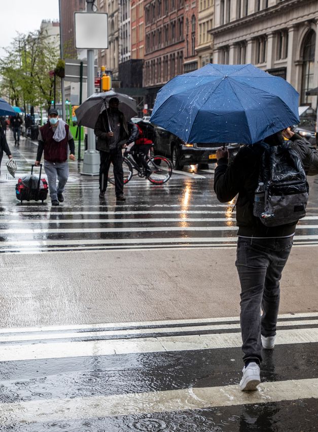
NEW YORK CITY STORMWATER RESILIENCY PLAN - MAY 2021 Helping New Yorkers understand and manage vulnerabilities from extreme rain
←
→
Page content transcription
If your browser does not render page correctly, please read the page content below
NEW YORK CITY
    STORMWATER
    RESILIENCY
    PLAN

    Helping New Yorkers understand
    and manage vulnerabilities from
    extreme rain

    MAY 2021

      1 | NYC STORMWATER RESILIENCY PLAN                                                  NYC.GOV/RESILIENCY

Cover photo by Jean Schwarzwalder, New York City Department of Environmental Protection
TABLE OF CONTENTS

INTRODUCTION................................................................................................................................4

DRAINAGE CONTEXT.....................................................................................................................5

MANAGING FLASH FLOODING......................................................................................................8

DESCRIPTION OF RESEARCH EFFORT AND MODELING METHODOLOGY...................................9

NEW YORK CITY STORMWATER FLOOD MAPS..........................................................................10

NEW YORK CITY STORMWATER RESILIENCY PLAN..................................................................12

APPENDIX A: ONGOING STORMWATER INVESTMENTS.............................................................17

APPENDIX B: MODELING APPROACH.........................................................................................20

2 | NYC STORMWATER RESILIENCY PLAN                                                                             NYC.GOV/RESILIENCY
KEY TERMS AND ACRONYMS
Agencies and Offices
BWSO: NYC Department of Environmental Protection Bureau of Water & Sewer Operations
CAU: NYC Mayor’s Community Affairs Unit
EM: NYC Emergency Management
DEP: NYC Department of Environmental Protection
DCP: NYC Department of City Planning
DOE: NYC Department of Education
DOT: NYC Department of Transportation
DSNY: NYC Department of Sanitation
FDNY: NYC Fire Department
MOR: NYC Mayor’s Office of Resiliency
MOS: NYC Mayor’s Office of Sustainability
MTA: Metropolitan Transportation Authority
NPCC: New York City Panel on Climate Change
NYCHA: New York City Housing Authority
NYPD: NYC Police Department
NYSDEC: New York State Department of Environmental Conservation
Parks: NYC Department of Parks & Recreation
SCA: NYC School Construction Authority

Other Acronyms and Terms:
CSO: Combined Sewer Overflow
DEM: Digital Elevation Model
FY: Fiscal Year
GIS: Geographic Information Systems
H&H: Hydrologic & Hydraulic (used to describe stormwater models)
IDF: Intensity-Duration-Frequency Curve (used to describe rainfall in stormwater models)
LiDar: Light Detection and Ranging (used to describe digital elevation models)
LTCP: Long Term Control Plan
MS4: Municipal Separate Storm Sewer System
NPCC: New York City Panel on Climate Change
PLUTO: Property Land Use Tax Lot Output map
ROW: Right of Way
Sewershed: an area of land where all sewers flow to a single WRRF.
SOP: Standard Operating Procedure
SLR: Sea Level Rise
SWMP: Stormwater Management Program
WRRF: Wastewater Resource Recovery Facility
INTRODUCTION
CLIMATE CHANGE CONTEXT
New York City is facing a wide variety of climate hazards that are      This Study included a novel modeling effort that produced, for the
not only felt today but will impact every aspect of life in the City    first time, public maps depicting vulnerability to rainfall-driven
over the coming decades. New Yorkers are well aware of the hazards      flooding. Prior to this effort, there had been no citywide analysis
associated with stronger coastal storms after Superstorm Sandy          performed focusing on rainfall-induced inland flooding that
claimed 44 lives and caused over $60 billion in regional damage in      utilized the City’s drainage models. The City has published maps
October 2012. Heat waves cause over 450 emergency department            of two storm scenarios, both of which incorporate future sea level
visits, 150 hospital admissions, and 13 heat stroke deaths              rise projections. Maps can be found at nyc.gov/resiliency.
annually.1 As a result of these hazards, New York City has initiated
ambitious coastal protection projects as well as a comprehensive        The subsequent pages describe the research and mapping effort
Cool Neighborhoods strategy. This plan initiates New York City’s        performed during the Study that resulted in NYC’s first Stormwater
planning process for another climate risk, extreme rainfall events,     Resiliency Plan.
which combined with sea level rise and other climate hazards will
contribute to the city’s overall climate risk going forward.            STORMWATER RESILIENCY PLAN
                                                                        In 2018, New York City Council passed Local Law 172,4 which
Extreme rainfall events are becoming more frequent and disruptive       required the City to produce maps showing areas of the city most
in New York City and beyond. According to The National Climate          vulnerable to increased flooding due to the anticipated effects of
Assessment, which summarizes current and future impacts of              climate change and publish a long-term plan to prevent or mitigate
climate change on the United States, the heaviest 1 percent of daily    such increased flooding. Consistent with the Local Law, the plan
rainfalls increased by 70 percent in the Northeast United States        and maps will be updated at least every four years, and periodically
between 1958 and 2012.2 Climate projections suggest that this           as new modeling is available and as climate change projections are
trend will continue and that New York City will likely experience       updated.
increased precipitation in the future. The New York City Panel on
Climate Change (NPCC) anticipates that by the end of the century,       The Stormwater Resiliency Plan (the “Plan”) outlines the City’s
the city could experience as much as 25 percent more annual rainfall    approach to managing the risk of extreme rain events. Truly
than today, and 1.5 times as many days with more than one inch          holistic planning for rain-driven flooding involves consideration
of rain.3 Without continued investment in strategies to prepare for     of both large storm events and the chronic worsening of average
the impacts of extreme rain events, NYC residents will experience       conditions. For this reason, the Plan addresses emergency response
increasing damage to private property, disruptions of surface and       procedures as well as accounting for increasing rainfall in standard
below ground transportation, and impacts to waterbodies. Building       design and long term planning of stormwater infrastructure.
on the NPCC climate projections, the City has undertaken detailed
                                                                        The Plan commits to four goals that optimize emergency response
research to better quantify how extreme precipitation will impact
                                                                        to extreme rainfall events and ensure that future City investments
neighborhoods citywide. This analysis focuses specifically on
                                                                        manage this climate risk. Each goal includes supporting sub-
rainfall (rather than other forms of precipitation such as snow or
                                                                        initiatives.
sleet) because it is overwhelmingly the driver of precipitation-based
flooding in NYC. The research will enable new, tailored solutions to    1.   Inform the public about flood vulnerability from extreme
manage this climate risk.                                                    rain;
                                                                        2.   Update NYC’s flash flood response procedures to prioritize
STUDY AND MAPPING                                                            response in vulnerable areas;
Vulnerability to extreme rainfall is an emerging area of study          3.   Advance policies that reduce urban flooding and research that
for municipalities in the United States. In 2017, New York City              informs future risk;
embarked on the Stormwater Resiliency Study to gain a fuller            4.   Leverage stormwater investments to help manage future
understanding of how more frequent and extreme rain events                   flood risk from extreme rain and sea level rise. Future
will affect the city. The Study was spearheaded by a multifaceted            investments can alleviate flooding throughout the city.
team of New York City agency staff, consulting teams, and               This document provides an overview of NYC’s existing drainage
academic partners. Led by NYC Mayor’s Office of Resiliency (MOR),       network, which is critical to understanding the base capacity to
NYC Department of Environmental Protection (DEP), and NYC               manage rain-driven flooding in the future. Flash flood emergency
Emergency Management (EM), the team was supported by staff from         procedures are also examined for optimization under increasingly
over 20 city agencies, external consultants, as well as an academic     extreme conditions. The document interprets findings from the
team from Brooklyn College, the Stevens Institute of Technology,        modeling effort, presents the public stormwater maps, and finally
the New School and Colorado State University.                           outlines the actions the City is taking to manage this climate risk.

4 | NYC STORMWATER RESILIENCY PLAN                                                                            NYC.GOV/RESILIENCY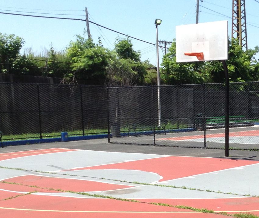
DRAINAGE CONTEXT
STORMWATER INVESTMENTS DESIGN OF SEWERS
Understanding NYC’s drainage network is essential to stormwater The City’s storm and combined storm sewers are designed to convey
resiliency planning. DEP manages the City’s water and wastewater surface stormwater runoff from rainfall events of varying intensities
services and has been committed to investments in, and policy and durations. The methodology used to design sewers for runoff
changes around, drainage improvement, green infrastructure and conveyance is based on precipitation intensity-duration-frequency
on-site stormwater management. These have the added benefit (IDF) curves. These diagrams are constructed from observed
of reducing the amount and slowing the rate of stormwater rainfall data of varying durations, from 5 minutes to 24 hours. The
entering the City’s sewer system. At the time of this report, the data are analyzed and arrayed graphically as precipitation intensity
NYC Green Infrastructure Program has led to over 10,000 green (inches/hour) as a function of rainfall duration (minutes or hours).
infrastructure projects constructed or currently in construction. Statistical procedures are used to develop a series of curves for
Green infrastructure describes an array of practices that use or various return periods (probabilities of occurrence).
mimic natural systems to manage stormwater runoff, taking
into account site-specific context. Over the last 30 years DEP The standard design criterion in New York City is to use the
has constructed Bluebelts (nature-based drainage systems) for intensity-duration values based on a storm with a 5-year return
approximately one third of Staten Island’s land area to provide period (e.g., 1.75 inches per hour for a one hour storm; 20 percent
location-specific drainage and preserve ecological function. DEP’s chance of occurrence in any given year) to calculate how large the
combined improvements to the drainage network, along with the sewer pipes need to be sized to appropriately manage stormwater.
Bluebelt network and green infrastructure improvements, have Certain older areas of the City are designed to a 3-year storm
increased NYC’s capacity to absorb extreme rainfall. DEP’s 2021 event. The sewer design flow is then determined by application
10 year capital plan includes $4.6B for sewer improvements and the of an equation using a runoff coefficient, a rainfall intensity
agency has committed $3.8B in sewer upgrades across the city over determined from an equation derived from the IDF analysis, and
the past 10 years. These investments include: the contributory drainage area. The design of combined sewers
• Constructing new high-level storm sewers to keep stormwater includes allowance for the sanitary flows. The IDF curve currently
out of the sewer system and reducing flooding; used by New York City is based on historical data from 1903-1951.
• Expanding new Bluebelts to Queens and Bronx, after success With climate change, the intensity and duration of a storm with a
in Staten Island; 5-year return period is likely to increase, and therefore the current
• Unprecedented focus on southeast Queens with approximately curve may not be adequate for designing infrastructure that is to
$2B of investment for comprehensive drainage system last decades.
improvements and $200M in the roadway network in Recent academic studies show that sub-daily rainfall intensity
partnership with DOT; may increase over the coming decades.5 Since rainfall information
• Over 10,000 distributed green infrastructure assets in started being collected, the number of days with extreme rainfall
construction or constructed; (defined as days of rainfall over 1.75 inches in Central Park) has
• New stormwater retention and detention rules for new or increased.6 Projections created by the Northeast Regional Climate
redeveloped properties – restricting how much and the rate at Center at Cornell University show the peak intensities of storms
which stormwater can be added to our sewer system; rising in the future. For example, the observed 5-year, 1 hour storm
• Private property incentives for green infrastructure including from 1970-1999 in Central Park produced an intensity of 1.83
grant funding for green roofs and a large-scale retrofit program inches per hour. The observed data used by DEP shows an intensity
kicking off in 2021. of 1.63 inches per hour. This is projected to increase to 2.15 inches
per hour from 2040-2069.7 The historical design context of NYC’s
Additional highlighted accomplishments and investments located in sewers is essential to consider when predicting performance under
Appendix A. future conditions and conducting long-term drainage planning.
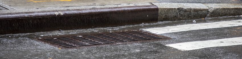
Figure 1: Typical catch basin (photo by Jean Schwarzwalder)
5 | NYC STORMWATER RESILIENCY PLAN NYC.GOV/RESILIENCY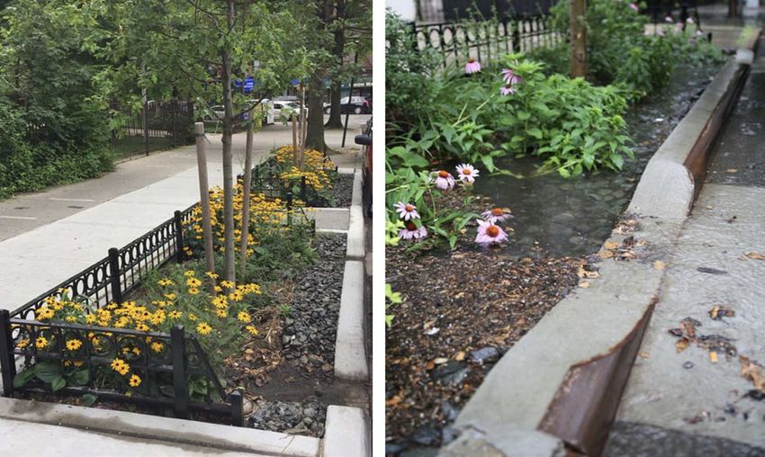
CURRENT DRAINAGE NETWORK                                               Combined Sewer System
New York City’s current infrastructure is comprised of an extensive
network of over 7,400 miles of sewer pipes that collect sanitary
sewage and stormwater, and the 14 Wastewater Resource Recovery
Facilities (WRRFs) that receive the flow. This network is one of
the City’s most significant assets, and has improved the health of
generations of New Yorkers. NYC’s sewer system is approximately
60 percent combined, which means it is used to convey both
sanitary and storm flows. When the sewer system is at full capacity,
a diluted mixture of rain water and sewage may be released into the
local waterways. This is called a combined sewer overflow (CSO).
This type of system is not unique. Combined sewer systems are
remnants of the country’s early infrastructure and are typically
found in older communities such as NYC. The remaining
approximately 40 percent of the system are separately sewered
areas, where sanitary sewers direct sewage directly to WRRFs while
separate storm sewers direct runoff to waterbodies (Figure 2).

Through a mix of active treatment and improvements to sewer
infrastructure, along with green infrastructure deployment,
NYC has reduced CSO volume by 80 percent since the 1960s.
This was achieved after $45B in investment. NYC has committed
an additional $10.6B to further reduce CSO releases under its
Watershed/Waterbody Facility Plan and Long Term Control Plan
(LTCP) programs for each sewershed.8 Models of the sewershed
were developed under the LTCP and provide the base information
for analysis in this plan, discussed in later chapters.

Finally, in 2015 the City was issued its first Municipal Separate
Storm Sewer System (MS4) Permit, which significantly expanded
the City’s previous obligations to reduce pollutants discharging       Municipal Separate Storm Sewer System
to the MS4 and required the City to develop a Stormwater
Management Program (SWMP).9 This includes numerous
programs designed to reduce pollution in stormwater.

                                                                       Figure 2: Combined and separate sewer systems.

6 | NYC STORMWATER RESILIENCY PLAN                                                                      NYC.GOV/RESILIENCY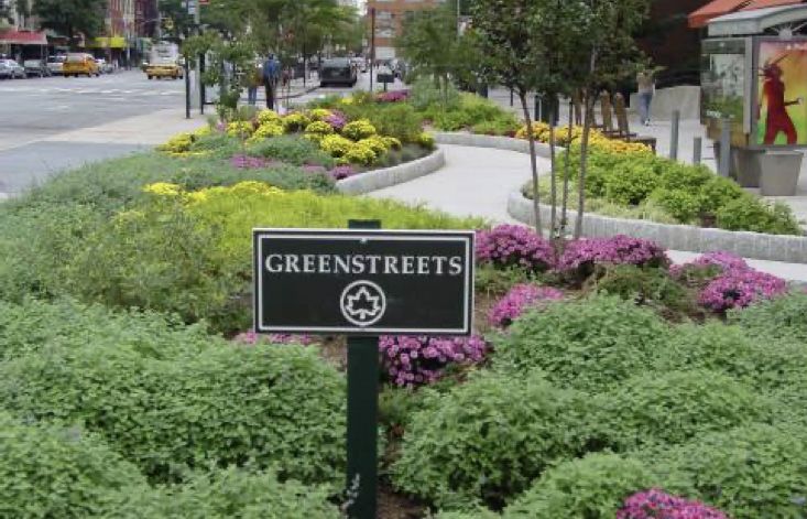
FUTURE DRAINAGE CONSIDERATIONS                                         Drainage with High Tide Today
While these measures have improved overall water quality, they
are often costly in terms of capital construction. Further, capital
investments provide diminishing returns, as it becomes more
and more challenging to treat the large volumes of stormwater
released in extreme events. Physical infrastructure alone cannot
fully manage the volume of water that must be managed during
extreme rain events to reduce flooding.

Flooding caused by heavy rain events is distinct from coastal
flooding. Stormwater infrastructure does not protect communities
from high-tide or “sunny day” flooding, nor storm surge that results
from coastal storms such as hurricanes and nor’easters. NYC’s
sewer systems depend on gravity to move water through pipes.
High tides made higher by sea level rise temporarily obstruct the
ability of stormwater infrastructure to drain streets as designed
and prolong flooding events (Figure 3). Impacts on stormwater
infrastructure in coastal areas may include:

•   Coastal flooding at outfalls without tidegates may drive
    backflow into the system, causing upland flooding through
    street drains. The prolonged presence of saltwater can
    damage stormwater infrastructure.
•   Shoreline erosion may expose stormwater infrastructure to
    potential damage.
•   Tidal inundation introduces sediment and debris that can
    clog storm drains, pipes, and outfalls.
•   More frequent, higher, and longer-lasting high-water events
    may drive up already high groundwater levels in some
    coastal communities. This change may reduce the soil’s
                                                                       Drainage with High Tide and Sea Level Rise
    ability to absorb stormwater, thus increasing runoff.

The impact of current and future coastal flooding on stormwater
management is a neighborhood-scale issue that demands a
coordinated, integrated response. Engineered options, such as
tide gates, can prevent backflows from surge events but they
impede flow through the outfall and do not prevent overland
inundation. More complex and expensive options that include
extensive modifications of existing stormwater practices such as
ponds and pumps must be considered together with a broader
watershed-scale approach that aligns community growth and
development with stormwater management goals. As coastal
protection measures are implemented, the City will continue to
develop integrated responses to address these coastal impacts on
stormwater infrastructure.

                                                                       Figure 3: Separate sewer system under current and future
                                                                       high tide conditions..

7 | NYC STORMWATER RESILIENCY PLAN                                                                       NYC.GOV/RESILIENCY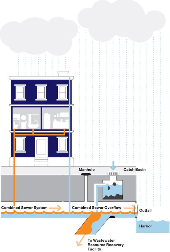
MANAGING FLASH FLOODING
According to EM’s Hazard History and Consequence Tool,12 there have been 19 instances of significant inland flooding caused by extreme
rain (an event with 3 inches or greater of rainfall total) between August 2007 and April 2021. The City has made significant progress on
efforts to reduce urban flooding impacts. Water quality targets have advanced practices that help manage urban flood risk. However, most
information on how and where urban flooding manifests remains highly anecdotal and focused on the most severe instances of flooding
in any particular event. More detailed understanding of areas vulnerable to extreme rain events is essential to prepare for and respond to
future emergencies, and was a main driver of the Stormwater Resiliency Plan research.

FLASH FLOOD RESPONSE
Response to flash flooding is a multi-stakeholder endeavor that        Department of Transportation (DOT):
requires both reactive emergency response procedures and               DOT is responsible for ensuring that the tops of catch basins are
proactive preventative measures. Within the city, extreme rain         clear on major arterial roads during flash flood emergencies, and
events can cause backups into basements, streets, and subway           maintaining city’s roadway network in a state of good repair.
tunnels, disrupting daily life.10 Despite the actions taken to
implement source controls for stormwater and improve water             Department of Sanitation (DSNY):
quality (see Appendix A), urban flooding persists in New York City.    DSNY is responsible for ensuring that the tops of catch basins are
Causes of this flooding vary with location. Flooding related 311       clear on minor roadways and can deploy equipment to help clear
complaints from 2004-2020 show a higher density of complaints          blockages, downed trees, and other hazards using their street
in areas influenced by tidal flooding, such as the Rockaways           sweeping units.
and Coney Island. Inland flooding complaints are prevalent in          Fire Department (FDNY):
Southeast Queens and Southern Brooklyn.11 More information             FDNY is notified of flash flood emergency plan activation and is
on flood cause and frequency is essential to better prepare for and    on call to provide dewatering equipment or personnel to assist in
respond to future emergencies.                                         the event of a flash flood emergency.

                                                                       Police Department (NYPD):
ROLES AND RESPONSIBILITIES                                             NYPD is notified of flash flood emergency plan activation and is
A significant rain event in August 2007 and the subsequent inter-
                                                                       on call to provide equipment or personnel to assist in the event
agency coordination spurred the creation of the Flood Mitigation
                                                                       of a flash flood emergency. NYPD’s responsibilities include traffic
Task Force, and the creation of an Flash Flood Emergency Plan,
                                                                       management for flooded roadways and assistance with security
managed by EM. Flash flood response is the responsibility of
                                                                       as needed.
several agencies:
                                                                       Metropolitan Transportation Authority (MTA):
Department of Environmental Protection (DEP):
                                                                       MTA is responsible for responding to flash flood emergency issues
DEP is the City agency with equipment available to proactively
                                                                       impacting their subways, buses, commuter rail assets, bridges,
clean the insides of catch basins, either before or during an event.
                                                                       and tunnels.
DEP’s Catch Basin Inspection Program identifies catch basins
that have a high likelihood of clogging during extreme rain            Community Affairs Unit (CAU):
events, and proactively cleans these basins before rain events.        The Community Affairs Unit (CAU) within the Mayor’s Office
Additionally, DEP’s Bureau of Water and Sewer Operations               monitors flash flood emergencies to determine whether there will
(BWSO) is responsible for maintaining NYC’s sewer networks in          be populations requiring assistance during or after a flash flood
good working order and addressing problems as they arise. BWSO         emergency due to property damage or other issues.
addresses hundreds of sewer-related 311 complaints each year and
activated its flash flood emergency plan 35 times in 2020 alone.

Emergency Management (EM):
EM is responsible for monitoring weather and activating the flash
flood emergency plan. The department provides interagency
coordination when issues arise during a flash flood event and can
monitor 311 flooding complaints. EM also manages Community
Emergency Response Teams (CERT), which are groups of
volunteers across the City that may be deployed to help keep catch
basin covers clean and alert agencies to flash flooding problems in
neighborhoods.

                                                                       Figure 4: Carroll Street and Fourth Avenue, Brooklyn
                                                                       Flash flood July 22, 2019

8 | NYC STORMWATER RESILIENCY PLAN                                                                            NYC.GOV/RESILIENCY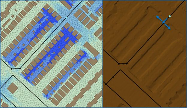
DESCRIPTION OF RESEARCH EFFORT AND MODELING METHODOLOGY
This modeling effort is the first of its kind in NYC for citywide         resolution. DEP developed an innovative composite rain-on-mesh
analysis of rainfall-induced inland flooding. Given limited past          approach to model extreme rainfall events, further described in
knowledge on areas in NYC prone to flooding from extreme rain             Appendix B. Note that certain areas of the sewer system could not
events, DEP, MOR and EM embarked upon an ambitious effort to              be modeled (for example, large private properties, large parkland
model these effects across the City in 2017. Modeling this type of        areas, areas with incomplete information). These areas were
flooding requires consideration of multiple urban flood drivers           masked on the maps developed for this effort and may be considered
including development of representative rainfall hyetographs (a           under subsequent modeling phases.
graphical representation of the distribution of rainfall intensity over
time), consideration of tidal conditions and climate change, and an       HOT SPOT ANALYSIS
understanding of localized sewer network capacity and overland            The modeling approach for Phase 2 increased resolution of the
drainage pathways. These components are complex individually,             LTCP models to facilitate street-level flooding analysis. “Hot
and when combined and considered on a city-wide scale, require            spots,” or areas particularly vulnerable to flooding, were identified
detailed hydrologic and hydraulic (H&H) models to evaluate and            by processing the Phase 1 model results to determine the most
predict flood risk. Although various individual analyses have             significant flood-prone areas.
been undertaken historically across the city, these have been on a
localized scale and often driven by coastal inundation as opposed         SEA LEVEL RISE AND INUNDATION
to inland rainfall. Given the complexity and scale required to            For sea level rise, the models predict the rain-derived flooding from
understand inland urban flood risk across the entire city, the City       the combined impact of rainfall and the coincident tidal condition
took a two-phased approach to modeling this vulnerability.                applied against the sewer outfalls. The maps also include coastal
                                                                          tidal inundation layers sourced from the NYC Flood Hazard Mapper.
PHASE 1
Through the City’s Town and Gown partnership program, DEP                 MAPPING APPROACH
engaged an academic team led by Brooklyn College to carry out             To create the flooding layers shown in the maps, two ranges of
the New York City Stormwater Resiliency Study and to develop              ponding depth were depicted: areas with depth greater than 4
hyetographs for scenarios used in the analysis as well as a preliminary   inches, and areas with depth greater than 1 foot. These two layers
H&H model. DEP used the hyetographs developed under Phase 1 as            were created for each of the 13 models, then merged into city-wide
well as the results of the Phase 1 models to identify hot-spots for       layers.
more detailed H&H modeling.
                                                                          MODEL VALIDATION AND UNCERTAINTY
The Phase 1 models did not include a detailed representation of the       The Phase 2 models were validated using the sewer flow
sewer system network (which was a focus in Phase 2 modeling). The         monitoring data collected under the LTCP program, as well as
academic team delivered the Phase 1 H&H model results to the City         associated rainfall and tidal conditions. Additional sewer flow or
in mid-2019 for use in Phase 2.                                           surface flooding data was not collected as a part of this effort.

The City also made significant efforts to identify a range of current     FUTURE MODELING EFFORTS
and future storm scenarios that would allow for adequate scenario         Future efforts can continue to provide more insight and refined
planning. In particular, the City prioritized understanding the           maps, including:
relationship between flooding driven by extreme rain and sea level        •   Additional model buildout to contain a higher percentage
rise, particularly for instances where sea level rise may impede the          of the sewers in each sewershed including refinement of the
normal functioning of the City’s drainage infrastructure.                     sewer network and additional survey;
                                                                          •   Calibration data collected for larger storm events at more
PHASE 2                                                                       locations across the city;
The Phase 2 modeling developed an H&H model for each                      •   Quantitative surface-level calibration data to provide insight
hydraulically independent area of the city, resulting in 13 different         to flooding extent and depth, as well as in-sewer response.
models, largely defined by the sewer networks draining to each                Existing calibration data is focused on the flows in the sewers
of the WRRFs. The models input complex rainfall hyetographs                   at select locations and not flooding in the streets.
compounded with tidal conditions and sea level rise for applicable
scenarios to output simulated stormwater flooding across the
city. The base models for the analysis were the City’s calibrated
LTCP models. Through this work, DEP leveraged the LTCP models
while improving their applicability for flooding analyses by adding a
2-dimensional overland component and significant sewer network

                                                                          For additional details about the modeling methodology, see Appendix B

9 | NYC STORMWATER RESILIENCY PLAN                                                                                   NYC.GOV/RESILIENCY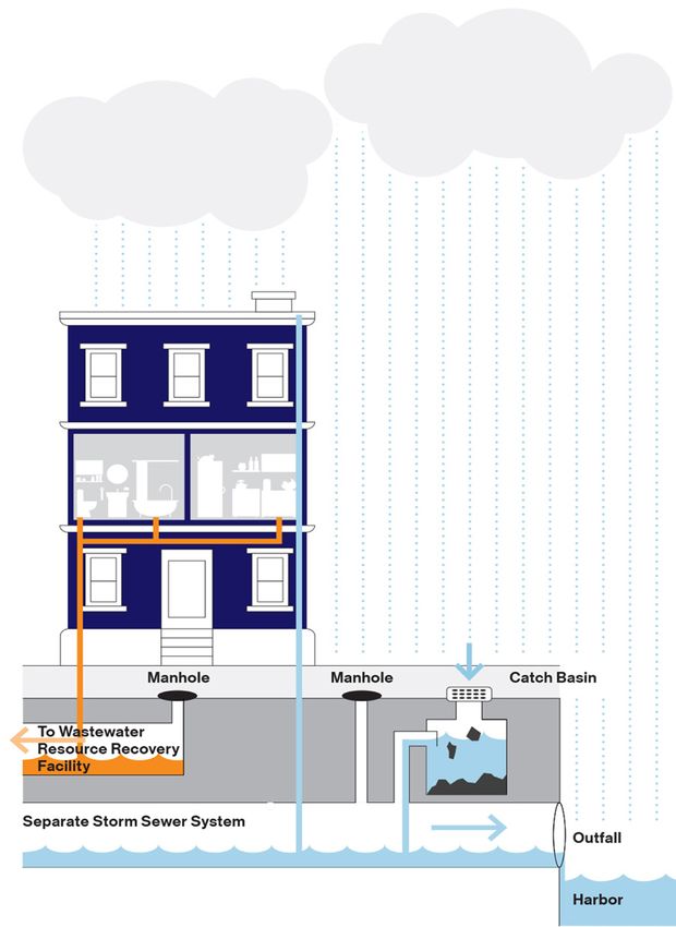
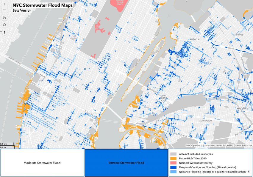
NEW YORK CITY STORMWATER FLOOD MAPS
The New York City Stormwater Flood Maps depict areas of predicted rain-driven flooding to help New Yorkers understand and prepare
for this risk. The City has created city-wide maps of two scenarios: moderate stormwater flooding under future conditions and extreme
stormwater flooding under future conditions (Figure 5). These maps are the first step to better understand increasing rainfall in NYC, and
additional maps will be released as information is available.

Figure 5: NYC stormwater flood map. Depicted here is the “extreme stormwater flood” scenario. Public maps can be accessed at nyc.gov/resiliency

STORMWATER FLOOD MAPS
These maps will help the City to prepare for future long-term             The maps show flooding impacts mainly concentrated in low
investment and target that investment in the most flood-prone             lying areas or areas with lower density of green/vegetated spaces
areas. They also are intended to help individual New Yorkers              that can increase stormwater infiltration. During coastal storm
understand risks related to extreme rainfall events. The maps             events there may be additional flooding caused by storm surge in
show areas of potential flooding from two scenarios of extreme            neighborhoods close to the shoreline (Table 1). Public maps can be
rainstorms, both of which include future sea level rise conditions.       found at MOR’s website at nyc.gov/resiliency and linked on DEP
Incorporating sea level rise allows the City to better understand         and EM’s websites.
the magnitude of the risk in the coming decades as well as preview
the performance of the existing drainage system.

10 | NYC STORMWATER RESILIENCY PLAN                                                                               NYC.GOV/RESILIENCY
RAIN-DRIVEN VERSES COASTAL FLOODING
There are key differences between rain-driven flooding and                 hours). Rain-driven flooding can occur suddenly and intensely, but
coastal flooding that must be considered in short-term emergency           flood conditions may subside more quickly (seconds to minutes).
planning and long-term design. Coastal flooding refers to both             Finally, as depicted on the maps, rain-driven flooding can be
flooding caused the tidal cycle as well as coastal storm events.           highly localized - intensely impacting smaller areas in dispersed
When planning for emergency response, the relative predictability          locations. Coastal flooding may impact a larger, consistent length
of the tides can allow for greater preparation or evacuations, and         and extent of the coastline. When rain events, coastal storms, and
the duration of the flooding conditions may be longer (minutes to          the tidal cycle compound, additional flooding may occur.

 Selected Impacts                                 Rain Driven Flooding                           Coastal Flooding (includes tidal
                                                                                                 flooding + coastal storms)
 Warning                                          Often comes with little warning                Tide cycle predictions allow for coastal flood
                                                                                                 warning
 Duration                                         Most major ponding lasts seconds to a few      Tidally influenced storm surge lasts 20
                                                  minutes                                        minutes to an hour
 Damage                                           Impacts interior drywall. Impact vehicles on   Salt water permanently damages electrical
                                                  the street or subgrade parking structures.     equipment
                                                  Potential electric/structural damage
 Geographic extent                                Impacts targeted areas based on location of    Impacts broad geographic area based on
                                                  heaviest rain. Dispersed impacts.              location/timing of tides, surge
Table 1: Distinctions between rain-driven and coastal flooding

MODELED SCENARIOS
The models are based on conservative assumptions to ensure                 MODERATE STORMWATER FLOOD SCENARIO
the maps were as accurate as possible without underestimating              This scenario illustrates the city streets which could experience
rainfall flood risk. The maps were built by analyzing a range              flooding during a moderate rainstorm combined with future sea
of rainfall scenarios to determine how flood patterns may change.          level rise. The map can be useful in identifying specific areas
They are based on the simplified assumption that rainfall occurs           where new public and private infrastructure will likely be required
uniformly across the city in order to conservatively assess possible       to supplement the sewer system. Flooding from this rainstorm
impacts in all neighborhoods. Additionally, the model assumes the          would temporarily disrupt transportation and enter buildings and
drainage system is fully functioning and that catch basins are free        basements, causing minor damage to contents and surfaces.
of debris or sediment. Both the moderate and extreme scenarios
show a severe rainstorm event that exceeds the design capacity of          This scenario reflects approximately two inches of rain falling in
the existing drainage system. Added sea level rise illustrates areas       one hour (also referred to as the 10-year storm, with approximately
that temporarily cannot drain due to tidal conditions blocking             10 percent chance of occurrence in any given year) combined with
storm drains and outfalls. The maps do not incorporate impacts             2.5 feet of SLR (NPCC 90th percentile estimate for the 2050s) (Table
from anticipated coastal protection projects in Manhattan, Staten          2).13 Flooding in this scenario is the result of the compounded
Island, and Queens.                                                        effects of both rainfall and the impacts of potential blocked storm
                                                                           drains and outfalls from sea level rise.
The maps show flood depth represented in two categories:
“nuisance” and “deep and contiguous.” Nuisance flooding is                 EXTREME STORMWATER FLOOD SCENARIO
classified as flooding at least 4 inches but less than 1 foot deep, and    This scenario shows significant flooding impacts of an extreme
was chosen to represent a low level of inundation that poses a less        rainstorm combined with future sea level rise. The map highlights
significant threat to public safety or major property damage. Deep         the considerable land areas that are predicted to flood and is useful
and contiguous flooding is categorized as flooding 1 foot deep or          for evaluating neighborhood-wide strategies to manage flood risk.
greater, and was chosen to represent a high level of inundation that
poses a significant threat to public safety and property damage.           This scenario reflects approximately 3.5 inches of rain falling in one
                                                                           hour (also referred to as the 100-year storm, with approximately 1
                                                                           percent chance of occurrence in any given year) combined with 4.8
 Map                 Rainfall            Sea Level Rise                    feet of SLR (NPCC 90th percentile estimate for the 2080s) (Table
                                                                           2).14 Flooding in this scenario is the result of the compounded
 Moderate            10-yr               MHHW + 2.5 feet
                                                                           effects of both rainfall and the impacts of potential blocked storm
 Extreme             100-yr              MHHW + 4.8 feet                   drains and outfalls from sea level rise.
Table 2: Stormwater flood map conditions.
MHHW = mean high high water

11 | NYC STORMWATER RESILIENCY PLAN                                                                                NYC.GOV/RESILIENCY
NEW YORK CITY STORMWATER RESILIENCY PLAN
The Stormwater Resiliency Plan ensures that future investments AGENCY OWNER: MOR | COMPLETION DATE: 2024
made by City agencies consider impacts on rain-driven flood In the longer term, MOR will work with city agencies to ensure
vulnerability, and that the City is tailoring operational resources that New Yorkers can look up their coastal and rain driven flood
to respond to more frequent and severe rain events. This is an vulnerability in one place. Currently, coastal flood maps are
unprecedented effort involving a wide variety of stakeholders and available on New York City’s Flood Hazard Mapper.18 NYC will
highly complex infrastructure. Within this context, the City has move towards an integrated flood mapping platform in the coming
identified strategic changes over a 10 year period that will better years.
manage flood risk from extreme rain for New Yorkers. The Plan
will provide the City with the necessary information for decision- GOAL #2 UPDATE NYC’S FLASH FLOOD
makers to reasonably assess emergent risks of rainfall-driven RESPONSE PROCEDURES TO PRIORITIZE
flooding and to take appropriate measures for managing those
risks. While the Stormwater Resiliency Plan will allow the City RESPONSE IN VULNERABLE AREAS
to better anticipate future flooding, there will still be limits as to
Initiative 1: Update Stormwater Mitigation Study Areas
what can be managed. Private property owners should continue to
AGENCY OWNER: EM | COMPLETION DATE: 2021
take efforts to minimize flood risk, and utilize resources included
After the August 7, 2007 extreme rain event, a Task Force convened
in DEP’s Flood Prevention page15 and EM’s Flood Preparedness
by Mayor Bloomberg identified NYC Stormwater Mitigation Study
page.16 The City has identified four key goals that guide the
Areas (SMSAs), where it was believed that urban flood issues were
implementation of the Stormwater Resiliency Plan. Initiatives will
most acute. EM worked with partner agencies to integrate these
support the achievement of these goals over the 10 year timeframe.
areas into the City’s Flash Flood Emergency Plan, prioritizing them
for flash flood response. Since 2007, the City has implemented
GOAL #1: INFORM THE PUBLIC ABOUT FLOOD projects that have reduced urban flood risk and shifted the nature
VULNERABILITY FROM EXTREME RAIN of urban flood risk across the City. MOR will work with EM to
coordinate across agencies to update, change, or remove the SMSA
Initiative 1: Release initial flood vulnerability maps to designations in the Flash Flood Emergency Plan.
the public Initiative 2: Ensure DEP’s Flood Activation and
AGENCY OWNER: MOR/DEP | COMPLETION DATE: 2021
The maps supporting this plan are publicly available and linked
Notification procedure and NYC’s Flash Flood Emergency
on DEP and MOR’s website with explanation of context and Plan are optimally aligned
intended use, as well as added to EM’s online Hazard Mitigation AGENCY OWNER: EM/DEP | COMPLETION DATE: 2022
Plan.17 Maps depicting additional storm scenarios will be available As part of the City’s Flash Flood Emergency Plan update, EM will
in subsequent Plan updates as new modeling is available and as coordinate across agencies to integrate any changes and align
climate change projections are updated. with DEP’s Flash Flood Plan Activation and Notification Standard
Operating Procedure (SOP). This will help to optimize operational
Initiative 2: Initiate stakeholder engagement agencies’ resource allocations.
AGENCY OWNER: MOR | COMPLETION DATE: 2021
Upon the release of the stormwater maps, the City will conduct
Initiative 3: Evaluate key locations to ensure coastal
outreach to ensure that impacted stakeholders understand the storm shelters maintain operational continuity during
maps, how flood risk from extreme rainfall affects them, and what extreme rain events.
steps they might take to avoid the worst impacts of flash flooding. AGENCY OWNER: EM | COMPLETION DATE: 2023
The stakeholder engagement will be led by MOR and supported by EM will evaluate pre-identified locations (such as coastal storm
partner City agencies. MOR will develop a presentation available on emergency shelters and commodity distribution points) critical to
its website explaining the maps (including model assumptions and response during a coastal storm. Evaluation may include securing
uncertainties) and will partner with DEP to ensure distribution funding for additional facility-specific analysis, identification of
of DEP’s toolkit of resources. MOR will reach out to community alternate locations in extreme rain events, and updating response
boards and elected officials to distribute the mapping and involve plans to reflect considerations for changing locations.
communities in understanding their specific vulnerabilities along
with making plans for reducing risk exposure. Initiative 4: Develop notifications for basement
Initiative 3: Build maps into interactive online platform dwellings to keep residents out of harm’s way
AGENCY OWNER: EM | COMPLETION DATE: 2023
showing citywide flood vulnerability from rain, coastal EM will pre-draft messaging regarding potential dangers for
storms, and sea level rise residents living in basement dwellings to be used for outreach and
notification in advance of forecasted extreme rain events.
12 | NYC STORMWATER RESILIENCY PLAN NYC.GOV/RESILIENCYInitiative 5: Model additional storm scenarios to further Additionally, under Chapter 19.1 amendments, sites that disturb
tailor NYC’s response management for various events 20,000 square foot or more of soil or increase impervious surfaces
by 5,000 square feet or more will also be required to manage the
AGENCY OWNER: MOR/DEP/EM | COMPLETION DATE: 2024
Water Quality Volume (WQv), currently defined as 1.5 inches,
EM will partner with MOR and DEP to support additional storm
using stormwater management practices (SMPs) dictated by DEP
scenario modeling to further refine the City’s response to extreme
SMP hierarchies. DEP has developed hierarchies for both combined
rainfall events.
and separate sewer areas. The SMP hierarchies prioritize vegetated
retention SMPs for both drainage areas with stormwater volume
GOAL #3: ADVANCE POLICIES THAT REDUCE control and stormwater treatment communicated as the underlying
URBAN FLOODING AND RESEARCH THAT goals for combined and separate sewer areas, respectively.
INFORMS FUTURE RISKS In September 2020, New York City Council passed Local Law 91
enabling DEP to move forward with the Chapter 19.1 amendments
Initiative 1: Call on NPCC to develop rainfall intensity
necessary to package the Unified Stormwater Rule amendments.19
projections for future years and collect ongoing rainfall Draft rules are anticipated to be published in Spring 2021 and in
intensity observations effect in 2022. A new New York City Stormwater Management
AGENCY OWNER: MOR | COMPLETION DATE: 2021 Guidance Manual will accompany the Unified Stormwater Rule to
When planning for future extreme rain, it is most important to provide clear guidance on requirements and design options. The
understand the intensity of future rainfall, as rainfall intensity draft manual will be published with the draft rules in Spring 2021.
drives flood impacts during storms. The NPCC estimates that
rainfall events will get more severe as climate change accelerates Initiative 4: Incorporate stormwater flood mitigation into
in the region. However, there are not precise estimates of how NYC’s Climate Resiliency Design Guidelines
rainfall intensities will change over time. Developing more precise AGENCY OWNER: MOR | COMPLETION DATE: 2023
rainfall intensity projections would help New Yorkers design The Climate Resiliency Design Guidelines establish City-wide
smarter and more cost effective facilities and allow for more guidance for incorporating forward-looking climate data into City
informed planning. capital projects.20 Over the next three years, MOR will partner
with agencies to review capital programs and identify projects in
Initiative 2: Facilitate green roof deployment in priority
areas that face high levels of risk from extreme rainfall. For these
areas projects, MOR will work with project teams to identify design
AGENCY OWNER: MOR/MOS | COMPLETION DATE: 2023 solutions to protect the asset as well as capture the maximum
In 2019, the New York State legislature renewed the Green Roof amount of rainwater on-site with consideration to future climate
Property Tax Abatement available for property owners installing projections. For example, in street and sidewalk resurfacing in
green roofs. It reauthorized the reimbursement of $5.23 per square flood-vulnerable areas, and pedestrian plaza construction in
foot of installed green roofs, and allowed the City to designate these areas, designers should consider design solutions focused
community districts that would receive an enhanced abatement on retention/detention of floodwaters and pervious materials
of $15 per square foot. With new information about urban flood wherever possible. MOR will subsequently incorporate lessons
vulnerability, there is an opportunity to include urban flood learned from these projects into these Guidelines.
vulnerability in the list of variables that the City might consider
when designating priority community districts receiving the GOAL 4: LEVERAGE STORMWATER
enhanced abatement. INVESTMENTS TO HELP MANAGE FUTURE
Initiative 3: Update on-site stormwater management FLOOD RISK FROM EXTREME RAIN AND SEA
requirements to reduce the amount and rate of LEVEL RISE. FUTURE INVESTMENTS CAN
stormwater entering city sewer system ALLEVIATE FLOODING THROUGHOUT THE CITY.
AGENCY OWNER: DEP | COMPLETION DATE: 2021
Initiative 1: Conduct additional modeling to identify the
DEP is proposing amendments to Chapters 31 and 19.1 of Title 15
of the Rules of the City of New York (RCNY) as part of a Unified most effective interventions that best manage flood risk
Stormwater Rule. The Unified Stormwater Rule, to be administered AGENCY OWNER: DEP | COMPLETION DATE: 2023
citywide, will update and align Chapter 31 stormwater quantity Under this initiative, DEP will integrate climate change forecasts
and flow rate requirements with Chapter 19.1 Construction/Post- in the development of coordinated long-range resiliency goals in
Construction permitting program water quality requirements. its ongoing mission to provide world-class and sustainable water
Under Chapter 31 amendments, the Unified Stormwater Rule and wastewater services now and for future generations. Utilizing
increases the amount of stormwater required to be managed on-site engineering analysis and operational knowledge, DEP is creating
and further restricts the release rates for all new and redevelopment a toolbox of resiliency interventions from which engineers and
projects that require a DEP House or Site Connection Proposal. planners can identify those that maximize effectiveness based
on site-specific conditions. The citywide stormwater model
13 | NYC STORMWATER RESILIENCY PLAN NYC.GOV/RESILIENCYwill be a constantly evolving tool for evaluating the design of in high-risk areas based on the specific needs of a neighborhood
proposed capital projects and identifying investments which are that assesses and evaluates the role that different interventions
cost effective and scalable to manage future flood risks. DEP will have in mitigating flooding, while also greening urban areas and
continue leveraging its in-house resources, augmented by several providing co-benefits to communities.
ongoing contracts, to expand and refine its citywide stormwater
model and evaluate impacts of future climate projections Initiative 5: Incorporate lessons learned into long term
developed by the Cornell University Northeast Regional Climate planning and revise drainage planning as appropriate
Center and the New York City Panel on Climate Change. with flood risk management as a key decision variable
Initiative 2: Analyze water and wastewater rate AGENCY OWNER: DEP | COMPLETION DATE: 2031
As discussed previously, DEP’s current sewer design standard is
structure options that could provide a more sustainable
based on IDF curves derived from historical rainfall data. Design
revenue stream and greater flexibility for investing in efforts for sewer infrastructure must take into account projected
climate resiliency future sea level rise (SLR), increased precipitation, and frequency
AGENCY OWNER: DEP/MOR | COMPLETION DATE: 2023 of high intensity storm events whenever possible. To reduce future
Capital expenses are expected to rise in the coming decades due to vulnerability from these elements, new and existing infrastructure
new mandates and necessary upgrades to aging infrastructure, to shall undergo risk-based engineering analyses to protect against
maintain and enhance DEP’s level of service, including addressing the impacts of climate change. DEP is currently revising its
climate change. At the same time, per capita water consumption drainage planning procedures to use a projected 5-year storm
is expected to remain at current low levels, or further decline. event in the final year of the sewer’s useful life, and will continue
Thus, an increased total cost of service is spread across a smaller to evaluate the drainage network under future storm scenarios.
demand number, which will increase budgetary pressures and
The capacity of a proposed sewer should be able to provide a level
make it more difficult to balance competing needs. To address
of service in which the system can adequately convey the current
this, DEP is carrying out the Sustainable Rate Structure Analysis,
5-year storm event without surcharging while providing a level of
which is a holistic rate structure study that will analyze water and
service equal to the 5-year storm event at the end of the useful life
wastewater rate structure options and customer assistance and
of that piece of infrastructure. Sewer infrastructure has a design
credit programs. This study will provide recommendations and
life of approximately 50 years, and a useful life of approximately
implementation options for DEP to achieve a more predictable,
100 years. As such, in 2021, the rainfall scenario that should be
equitable, and sustainable revenue stream to allow for more
used for evaluating future sewer projects is the projected average
flexibility in balancing regulatory objectives with the growing
rainfall intensity values for the years 2070-2099.
need to invest in climate resiliency and sustainability, while
maintaining customer affordability. Additionally, DEP will expand upon the modeling completed
for this effort and continue developing a citywide hydrologic
Initiative 3: Establish criteria for tiering neighborhoods and hydraulic (H&H) model to better estimate runoff flow for
based on flood vulnerability various climate scenarios to be included in the drainage planning
AGENCY OWNER: DEP/DCP/MOR | COMPLETION DATE: 2023 process. This model is expected to be sufficiently complete to
As seen in the maps, heavier rain and sea level rise is expected allow evaluation of future rainfall scenarios to inform necessary
to increase the frequency, extent, and duration of chronic and and constructible design changes to sewer construction projects
acute flooding events. DEP, in coordination with DCP and other scheduled for award in FY 2024. By modeling forward-looking
City agencies, will establish criteria for tiering neighborhoods rainfall and SLR scenarios, DEP can evaluate the sewer system for
based on their vulnerability to flooding. While vulnerability to future rainfall scenarios as well as extreme rainfall scenarios that
flooding indicated by modeling results will be a primary indicator may occur with more frequency due to climate change. DEP can
of vulnerability, other factors such as additional climate risks, be better prepared to allocate and prioritize resources for capital
existing infrastructure capacity, current and future projects, improvement projects to prevent future damage from increased
and environmental justice will also be considered to ensure an rainfall and sea level rise predictions in the future as a result of
equitable approach towards implementing solutions for flooding climate change.
hotspots. Finally, DEP will continue to exchange best practices for addressing
issues related to managing intense rainfall and sea level rise with
Initiative 4: Assess and evaluate feasible flood risk
other cities facing similar challenges. DEP’s ongoing partnership
strategies for implementation based on tiers with the City of Copenhagen will focus on enhancing stormwater
AGENCY OWNER: DEP | COMPLETION DATE: 2027 management and resiliency through storage and surface flow
Strategies for addressing flooding should be tailored to the specific conveyance in addition to drainage network buildouts, that also
characteristics of a neighborhood and the feasibility and cost of creates inspiring urban areas with co-benefits for communities.
interventions. As a part of the process of tiering neighborhoods Successful partnerships such as this allow DEP to identify and
based on flood vulnerability, DEP, in coordination with other develop innovative solutions to prepare for more extreme rain
City agencies, will develop a framework for mitigating flooding events, or cloudbursts, brought about by climate change.
14 | NYC STORMWATER RESILIENCY PLAN NYC.GOV/RESILIENCYGOAL #1: INFORM THE PUBLIC ABOUT FLOOD VULNERABILITY FROM EXTREME RAIN
INITIATIVES NYC AGENCY OWNER COMPLETION
1: Release initial flood vulnerability maps to the public MOR 2021
2: Initiate stakeholder engagement MOR/DEP 2021
3: Build maps into interactive online platform showing citywide flood vulnerability from
MOR 2024
rain, coastal storms, and sea level rise
GOAL #2: UPDATE NYC’S FLASH FLOOD RESPONSE PROCEDURES TO PRIORITIZE RESPONSE IN VULNERABLE AREAS
INITIATIVES NYC AGENCY OWNER COMPLETION
1: Update Stormwater Mitigation Study Areas EM 2021
2: Ensure that DEP’s Flash Flood Activation and Notification SOP and NYC’s Flash Flood
EM/DEP 2022
Emergency Plan are optimally aligned
3: Evaluate locations of key shelters and commodity distribution points to ensure that
EM 2023
coastal storm shelters maintain operational continuity during extreme rain events
4: Develop notifications for basement dwellings to keep residents out of harm’s way EM 2023
5: Model additional storm scenarios to further tailor NYC’s response management for
MOR/DEP/EM 2024
various events
GOAL #3: ADVANCE POLICIES THAT REDUCE URBAN FLOODING AND RESEARCH THAT INFORMS FUTURE RISKS
INITIATIVES AGENCY OWNER COMPLETION
1: Call on NPCC to develop rainfall intensity projections for future years and collect
MOR 2021
ongoing rainfall intensity observations
2: Facilitate green roof deployment in priority areas MOR/MOS 2023
3: Update on-site stormwater management requirements to reduce the amount and rate of
DEP 2021
stormwater entering city sewer system
4: Incorporate stormwater flood mitigation into NYC’s Climate Resiliency Design Guidelines MOR 2023
GOAL #4: LEVERAGE STORMWATER INVESTMENTS TO HELP MANAGE FUTURE FLOOD RISK FROM EXTREME RAIN AND SEA
LEVEL RISE. FUTURE INVESTMENTS CAN ALLEVIATE FLOODING THROUGHOUT THE CITY.
INITIATIVES AGENCY OWNER COMPLETION
1: Conduct additional modeling to identify the most effective interventions that best
DEP 2023
manage flood risk
2: Analyze water and wastewater rate structure options that could provide a more sustainable
DEP/MOR 2023
revenue stream and greater flexibility for investing in climate resiliency.
3: Establish criteria for tiering neighborhoods based on flood vulnerability and risk DEP/DCP/MOR 2023
4: Assess and evaluate feasible flood risk strategies for implementation based on tiers DEP 2027
5: Incorporate lessons learned into long term planning and revise drainage planning as
DEP 2031
appropriate with flood risk management as a key decision variable
15 | NYC STORMWATER RESILIENCY PLAN NYC.GOV/RESILIENCYAPPENDIX 16 | NYC STORMWATER RESILIENCY PLAN NYC.GOV/RESILIENCY
APPENDIX A: ONGOING
STORMWATER INVESTMENTS
LONG TERM CONTROL PLANS
In 2012, DEP and DEC signed a groundbreaking agreement to reduce
CSOs using a hybrid green and grey infrastructure approach. As part
of this agreement, DEP has developed 10 waterbody specific and
one city-wide Long Term Control Plans (LTCPs). The goal of each
LTCP is to identify appropriate combined sewer overflow controls
necessary to achieve waterbody-specific water quality standards,
consistent with the Federal CSO Policy and the water quality goals
of the Clean Water Act. Over the last several decades, the City has
invested more than $45B in the construction and upgrade of critical     Figure A1: DEP Rain Gardens
wastewater and drainage infrastructure to improve the health of
our City’s vital ecosystems. In recent years, the City has committed
an additional $10.6B to continue the legacy of innovation and
investment to usher in a new era of environmental protection for
its waterbodies. DEP’s website summarizes the LTCP Program
commitments and benefits.21

NYC GREEN INFRASTRUCTURE PROGRAM
New York City’s 2010 Green Infrastructure Plan built upon
and extended the commitments made in PlaNYC and the 2008
Sustainable Stormwater Management Plan. This plan provided
a detailed framework and implementation plan to meet the twin
goals of better water quality in New York Harbor and a livable and      Figure A2: NYC Greenstreets Plaza
sustainable New York City. This plan was the framework through
which NYC updated its consent order with New York State in 2012,             Grant Program offers funding for the design and construction
and officially integrated green infrastructure and source control            of green roof retrofits on private property in New York City. In
strategies into its water quality compliance framework. The Plan led         2021 DEP will kick off a new large-scale green infrastructure
to the launch of the New York City Green Infrastructure Program.             retrofit incentive program with the goal of installing green
                                                                             infrastructure assets on private property that manage a
The New York City Green Infrastructure Program has led to                    stormwater volume equivalent to 200 “greened acres”. The
over 10,000 green infrastructure practices, managing over 1,200              program targets large parcels, 50,000 square feet or greater, in
“greened acres,” constructed or currently in construction at the time        the combined sewer areas of the City with large impervious
of this report.22 Through the Program, DEP has formed important              (paved) areas.
relationships with city agencies and expanded sustainable
stormwater management principles to streets and public spaces.          STREET TREES
The Program has three primary implementation areas:                     New York City’s almost 700,000 street trees intercept over 1 billion
                                                                        gallons of stormwater every year, while reducing CO2 emissions
•   Right-of-Way (ROW) Green Infrastructure: In 2012,                   by over 600,000 tons. The annual value of the stormwater, energy,
    DEP launched area-wide green infrastructure projects, in            and pollution benefits provided by street trees is $109M, according
    partnership with DOT and Parks, and has achieved the vast           to Parks.23 As part of the New York City Million Trees initiative,
    majority of stormwater management through the installation          220,000 street trees were planted, with the rest of the million trees
    of ROW practices such as rain gardens and infiltration basins.      planted either in parks or on private property.24
    DEP is currently expanding its ROW green infrastructure
    portfolio to include large capture median practices sized to        GREEN AND SOLAR ROOF MANDATES
    manage precipitation events larger than standard practices.         In 2019, there were just 736 green roofs in New York City,25 covering
•   Public Property Retrofits: DEP, with Parks, NYCHA, DOE              60 of the 40,000 acres of rooftop space.26 As part of the New York City
    and SCA, continued green infrastructure project design              Climate Mobilization Act passed in 2019, New York City Council
    development on almost 200 publicly owned properties as of           passed Local Laws 92 and 94, which require new and substantially
    the release of this report. Newly constructed projects include      renovated or enlarged rooftops to incorporate sustainable roofing
    green infrastructure schoolyards with the Trust for Public          on all available roof space. The City anticipates that these laws will
    Land and DOE and SCA.                                               help buildings manage up to 1M additional gallons of stormwater
•   Private Property Initiatives: DEP’s Green Infrastructure            per year, and help manage water quality and urban flooding.

17 | NYC STORMWATER RESILIENCY PLAN                                                                             NYC.GOV/RESILIENCY
You can also read