Review of impacts on wilderness - Vonarskarð 4x4 Hypothetical Access Route - The Wildland Research ...
←
→
Page content transcription
If your browser does not render page correctly, please read the page content below
Vonarskarð 4x4 Hypothetical Access Route
Review of impacts on wilderness

                 Vonarskarð 4x4 Hypothetical Access Route
       Review of impacts on wilderness

              A report by the Wildland Research Institute for Náttúruverndarsamtök Íslands,
                Samtök um náttúruvernd á Norðurlandi, Skrauti and Ungir umhverfissinnar
                                            September 2021

                                                   1
Vonarskarð 4x4 Hypothetical Access Route
 Review of impacts on wilderness

Contents

Executive summary                                                 3

1. Introduction                                                   6
2. Defining wilderness and approaches to mapping                  10
3. Developing a wilderness model                                  15
4. Attribute maps                                                 18
5. Results: impacts on the patterns of wilderness in Vonarskarð   35
6. Potential impact on wilderness                                 46
7. Conclusions and recommendations                                52

                                                      2
Vonarskarð 4x4 Hypothetical Access Route
    Review of impacts on wilderness

Executive summary
This report has been prepared on behalf of four NGOs in Iceland, namely Iceland Nature Conservation
Association, (Náttúruverndarsamtök Íslands), The Icelandic Youth Environmentalist Association (Ungir
umhverfissinnar), Skrauti - Nature Conservation Society, and SUNN - North Iceland Nature Conservation
Association (Samtök um náttúruvernd á Norðurlandi), by the Wildland Research Institute, UK. The report
assesses the potential impacts of the hypothetical changes to 4x4 1 access in the Vonarskarð area in terms of
likely changes to the patterns of wilderness quality in the local area resulting from impact to remoteness and
visibility of human artefacts. The Vonarskarð area is defined as the area of the central highlands about and
above 950m between the Tungafellsjökull and Vatnajökull icecaps in the northwest of the Vatnajökull National
Park. The area covers approximately 113 km2 of mainly mountains, hills and sand dissected by rivers, as well as
containing small, vegetated wetland areas and several areas of high geothermal activity2.
The work presented here builds on previous mapping projects carried out for both the European Union and the
Scottish Government together with similar analyses carried out for the proposed Hvalá hydro powerplant in the
Drangar Peninsula, Northwest Iceland. The Wilderness register and indicator for Europe (Kuiters et al., 2013)
provides both a compilation of existing designated wilderness areas across Europe, using databases such as the
EEA and WDPA, and a map of wilderness and wild areas in Europe based on appropriate definitional and habitat
criteria. This shows that the total area of the top 1% wildest land across the whole of EU/EEA is 56,810 km 2 of
which 24,063 km2 is found in Iceland which accounts, in other words, for a little over 42% of the top 1% wildest
land in Europe. The mapping methods used involve the integration of digital spatial datasets on land cover, land
use and remoteness from settlements and mechanised access. A similar and more detailed approach was used
to map wildness and wild land areas across Scotland and its national parks. This has allowed the Scottish
Government to identify 42 Wild Land Areas for use in supporting policy on landscape protection and decision
making about large scale developments such as renewable energy infrastructure.
Work at these regional and national levels allows the use of high-resolution spatial data and detailed analyses
to accurately model and predict the geographical extent of impacts from existing and proposed development
on changes to natural land cover, reductions in remoteness and increased visual impact, which together can be
used to map wilderness quality in a rigorous, robust and repeatable manner. Similar methods and approaches
to those used in Scotland are applied here. The methods and datasets applied mirror those used to successfully
map wilderness quality in the Drangar Peninsula and predict likely impacts from the proposed Hvalá hydro
powerplant. These are reapplied here to map wilderness quality in the Vonarskarð area of the central Highlands
of Iceland and predict the impacts on wildness from reverting the changes made in 2011 to the 4x4 access rules.
Reverting the changes to 4x4 access in Vonarskarð would involve re-opening the previous route, connecting
existing gravel roads or tracks to the north and south. This would allow 4x4 vehicles to drive between the
roadheads at Svarthöfði in the south and Gjóstuklif in the north. Analyses developed as part of this report show
that re-opening this route would have a significant adverse impact on the wilderness qualities of this area, with
the outcome that the area of core wilderness in the vicinity would be reduced by approximately 6515ha or 54%
of the total area of study (See Figure 1.1). This work refers only to impacts of summer/autumn 4x4 access and
does not consider winter (on snow) driving. The relatively short season of motorized access possibilities (except
on snow or ice) in the central highlands and Vonarskarð in particular being late summer and autumn (mid-late
July to -September-October) each year.
This analysis is based on a mapping of four commonly used attributes of wilderness quality across the Vonarskarð
and its surrounding area. These are: naturalness of land cover, remoteness from mechanised access, absence of
modern human artefacts, and ruggedness of the terrain. Naturalness of land cover takes satellite-based maps
of land cover into account and measures the degree of human modification through agriculture, grazing and
construction where these occur. Remoteness measures the time taken to walk from any point of mechanised
access including roads usable by 2WD (two-wheel drive) and 4WD (four-wheel drive) vehicles, taking terrain,

1
 Four-wheel drive or 4WD vehicles
2
 Baldursson, Trausti, and Magnússon, Borgþór. Umsögn um Vonarskarð. Náttúrufræðistofnun Íslands. (2019).
https://www.ni.is/sites/default/files/atoms/files/uttekt_um_vonarskard.pdf

                                                       3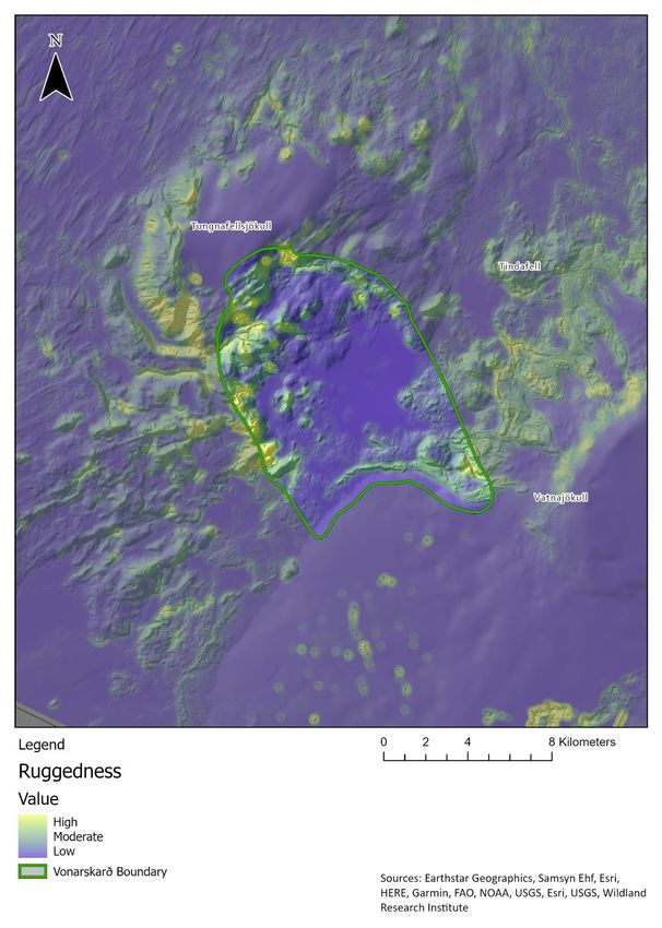
Vonarskarð 4x4 Hypothetical Access Route
    Review of impacts on wilderness

land cover, and barrier features such as lakes and large rivers into account. Absence of modern human artefacts
measures the visual impact from built features in the landscapes such as buildings, roads, dams and other
structures taking size, distance and intervening terrain into account. Ruggedness is measured directly from the
topography and is a key aspect of wilderness quality that provides a measure of both scenic quality/interest and
the challenging nature of the terrain. All four attributes are combined using multi-criteria evaluation (MCE)
methods to provide an overall measure of wilderness quality and its spatial pattern and variability across the
study region. By inserting the hypothetical 4x4 route and its associated effects and landscape modifications into
the model, this approach can provide rigorous and robust estimates of the level of impact on patterns of
wilderness quality in the locality of the route. The mapping work described in the report is confirmed and
supported by local knowledge gained through communication with local park managers and rangers, and
through site visits and ground truthing work carried out in August 2021.
Vonarskarð is an area which is at present largely free from visual impact and currently contains almost no
modern human infrastructure except for old informal 4x4 routes 3 and earth dams built between 1980-1981 by
the National Power Company, Landsvirkjun, in the attempt to divert river flows to the southwest towards the
catchment area of rivers Kaldakvísl (where Hágöngulón Reservoir is now), Tungnaá and Þjórsá, the largest
hydropower area of Iceland. The analyses presented here show that reversing the changes made in 2011 and
re-opening the 4x4 route (as lobbied for by 4x4 groups) would significantly impact this wilderness area by
increasing vehicle damage to fragile soils and vegetation, increasing foot erosion in sensitive geothermal areas
and considerably increasing the visual impact from vehicles, their tracks and associated reductions in
remoteness.
The 2013 Nature Conservation Act No. 60/2103 which entered in to force in November 2015, introduces the
management objectives for wilderness protected areas in Iceland as follows: "The protection should aim to
safeguard the characteristics of the areas e.g. to maintain diverse and unusual landscapes, panoramas and/or
conserve complete large ecosystems, and ensure that present and future generations can enjoy therein solitude
and nature without disturbance from man-made infrastructures or traffic from motor vehicles“. This follows
closely those objectives as stated in the IUCN standards and guidelines for Category 1b Wilderness Areas. Article
5 of the Nature Conservation Act 2013 provides some basic numeric criteria to help highlight potential
wilderness areas in Iceland. These are: “An area of uninhabited land that is in principle at least 25 km 2 in size or
so that one can enjoy solitude and nature without disturbance from man-made structures or the traffic of
motorized vehicles and in principle at least 5 km away from man-made structures and other evidence of
technology, such as power lines, power stations, reservoirs and elevated roads”. These numeric criteria are
relative, thus giving rise to the need for more robust mapping approaches than those carried out hitherto.
It is important to note that wilderness protection is also mentioned within the new National Planning Strategy
(Landsskipulagsstefna) that was adopted by a Parliament Resolution in March 2016. It states that: “The Planning
Agency and the Environment Agency are responsible for regularly updating maps of the extent and development
of wilderness in the central highlands. This includes setting criteria for assessing the extent of the wilderness
based on planning considerations and having regularly updated maps on the extent of the wilderness accessible
to the planning work of local and other parties“.
While the development of policy and legislation for the protection of wilderness qualities in the landscapes of
Iceland is in its infancy and much of the existing focus has been on the central highlands region, the government
has a duty of care to help preserve this important resource across the island. Work presented here will help
inform further development of government policy on wilderness and associated planning and protection
measures. The recent addition to the Nature Conservation Act (February 2021) makes wilderness mapping
mandatory for the whole of Iceland by June 2023.
The Wildland Research Institute (WRi) is an independent academic institute with specialist knowledge in
wilderness, policy advice, mapping and landscape assessment. WRi have detailed, in-depth knowledge of the
wilderness mapping processes and are the originators of the original wilderness methodology developed for the
two Scottish National Parks and have acted as technical advisors to the Scottish Government during their
national wild land mapping process. In addition, WRi are co-authors of the EU Wildness Register and mapping
programme (2013) and are currently helping the IUCN map wilderness quality across France. They have also

3
    Many tyre tracks are still visible ten years after the changes made to the 4x4 access in Vonarskarð.

                                                          4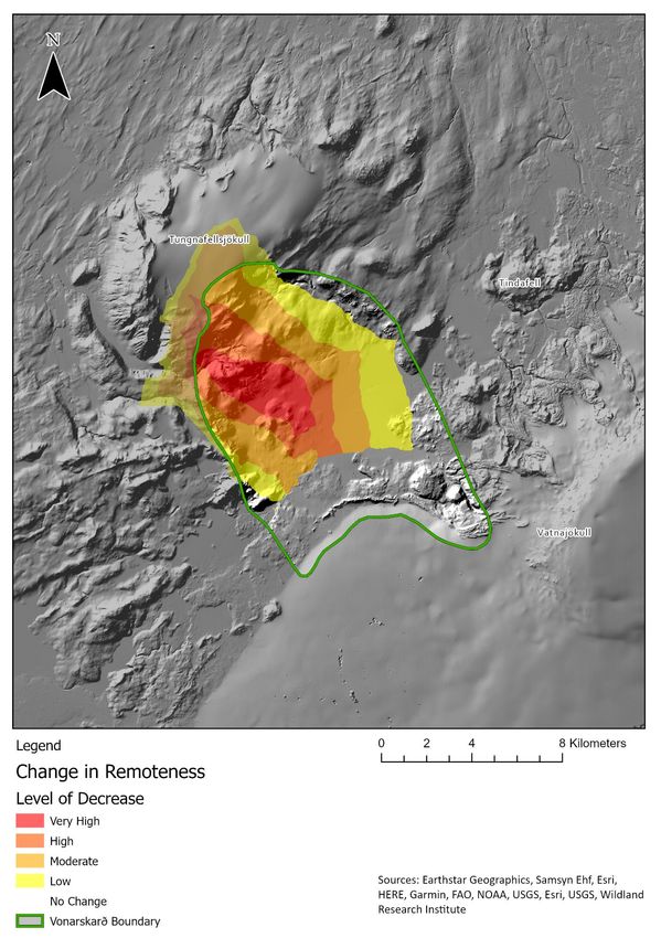
Vonarskarð 4x4 Hypothetical Access Route
 Review of impacts on wilderness

worked on mapping wilderness character for the US National Park Service and wilderness quality and intactness
in China. WRi have existing experience in applying these mapping approaches to modelling wilderness quality
and impacts associated with planned developments in Iceland and are fully conversant with both the landscape
and datasets available for Iceland. WRi are authors of the much-cited report on "The Status and Conservation of
Wilderness in Europe" commissioned by the Scottish Government.

                                                      5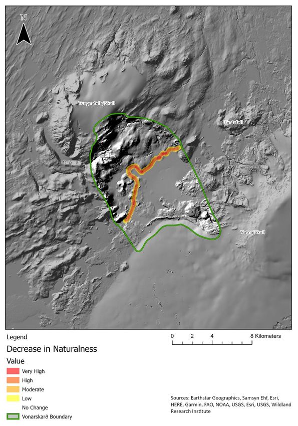
Vonarskarð 4x4 Hypothetical Access Route
    Review of impacts on wilderness

1. Introduction
1.1 This report has been prepared on behalf of four Icelandic NGOs, namely Iceland Nature Conservation
Association, (Náttúruverndarsamtök Íslands), The Icelandic Youth Environmentalist Association (Ungir
umhverfissinnar), Skrauti - Nature Conservation Society, and SUNN - North Iceland Nature Conservation
Association (Samtök um náttúruvernd á Norðurlandi). The report provides an overview of the national policy
and planning frameworks on wilderness in Iceland and the mapping methods used to define areas of wilderness.
The report further reviews the status of wilderness in the vicinity of a hypothetical re-opening of a 4x4 route.
The report assesses the potential impacts of this hypothetical 4x4 access in the Vonarskarð area in terms of
wilderness as defined by the 2013 Nature Conservation Act No. 60/20134 using internationally recognised
mapping techniques together with local knowledge based on information provided by local park managers and
field visits.
1.2 It is recognised here that 4x4 access, including the use of so-called “super jeeps”, to access remote off-road
areas of the central highlands is a controversial aspect of Iceland’s domestic and international tourism industry.
Construction of roads for energy development (hydro power and geothermal) have resulted in greater use of
4x4 vehicles to access remote wilderness areas for recreation and tourism. This has created conflict between
recreational users and conservationists due to the environmental impacts associated with 4x4 usage including
loss of opportunities for solitude and damage to fragile ecosystems from vehicle tracks 5.
1.3 The report examines the hypothetical re-opening for 4x4 access in the context of its potential and likely
impacts on wilderness within the Vonarskarð area. This is supported by mapping carried out by WRi using
rigorous, robust and repeatable techniques to show how the proposed route would reduce the total area of
wilderness in Vonarskarð and how the proposed route would significantly compromise the wilderness quality
and values across the area. The study area and its location is shown in Figure 1.1. Evidence from fieldwork carried
out in August 2021 shows that previous 4x4 tracks can still be seen in places and that new tracks from illegal 4x4
use are highly noticeable where they occur. This shows the soils and vegetation of the Vonarskarð area to be
highly sensitive to disturbance and erosion by off-road vehicles with the tracks made visible for many years.
1.4 The details on the hypothetical re-opening of 4x4 route are drawn from Open Street Map based on existing
routes as either GIS Shapefiles6 or from personal communication with local experts including Vatnajökull
National Park officers7. The 4x4 route, as occasionally driven from the 1950s until the first Management Plan for
Vatnajökull National Park entered into force in 2011, is shown in Figure 1.2.
1.5 This report has been prepared by the Wildland Research Institute (WRi), an independent academic institute
with specialist knowledge in wilderness, geographical information systems (GIS) and landscape assessment 8.
WRi have detailed, in-depth knowledge of the wilderness mapping processes. WRi are the originators of the
original wilderness mapping methodology developed for the two Scottish National Parks 9,10 and have acted as
technical advisors to Scottish Natural Heritage (SNH) and the Scottish Government during their original Phase I

4
  See: https://www.althingi.is/lagas/nuna/2013060.html
5
  Árnason, Þ., 2020. Exploring wilderness in Iceland: Charting meaningful encounters with uninhabited lands. In
Rethinking Wilderness and the Wild (pp. 189-204). Routledge.
6
  Shapefiles are machine-readable map data files for using GIS analyses and mapping.
7
  Local knowledge was gained via a conference call with Fanney Ásgeirsdóttir, Park Manager (þjóðgarðsvörður)
and Jóna Björk Jónsdóttir, Assistant Park Manager in early summer 2021. In addition, in-the-field information
was provided through contact with Fanney Ásgeirsdóttir and Auður Lilja Arnþórsdóttir, Park Ranger
(landvörður) during site visit and ground truthing in August 2021.
8
  http://www.wildlandresearch.org
9
  http://www.geog.leeds.ac.uk/groups/wildland/Cairngorm2008.pdf
10
   https://www.lochlomond-trossachs.org/wp-content/uploads/2016/07/Research_WildnessStudy2011.pdf

                                                        6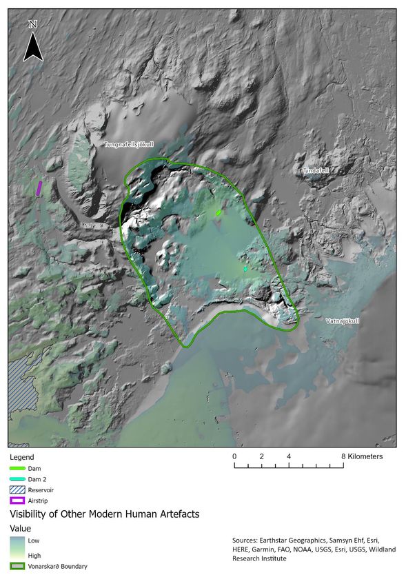
Vonarskarð 4x4 Hypothetical Access Route
 Review of impacts on wilderness

mapping process11. In addition, WRi have been contracted, together with partners Alterra and PAN Parks, by the
European Union Environment Agency (EEA) to extend the methodology to the whole of the Europe 12,13. This
approach has also been adopted in a modified form for use in mapping wilderness character by the US National
Park Service within national park wilderness areas in the United States14,15 and has also been applied in China16.
WRi have existing experience in applying these mapping approaches to modelling wilderness quality and impacts
associated with planned developments in Iceland and are conversant with both the landscape and datasets for
Iceland. WRi are also the authors of the much-cited report on "The Status and Conservation of Wilderness in
Europe" commissioned by the Scottish Government17. WRi are currently working for IUCN France to develop a
map of Haute Naturalité (High Naturalness)18, again based on modifications to the mapping approaches
developed in Scotland.

11
   Carver, S., Comber, A., McMorran, R., & Nutter, S. (2012). A GIS model for mapping spatial patterns and
distribution of wild land in Scotland. Landscape and Urban Planning, 104(3), 395-409.
12
   Europe's ecological backbone: recognising the true value of our mountains. EEA Report No 6/2010
13
   Wilderness register and indicator for Europe Final report 2013 (draft) Contract N o:
07.0307/2011/610387/SER/B.3
14
   Tricker, James; Landres, Peter; Dingman, Sandee; Callagan, Charlie; Stark, John; Bonstead, Leah; Fuhrman,
Kelly; and Steve Carver. 2012. Mapping wilderness character in Death Valley National Park. Natural Resource
Report NPS/DEVA/NRR-2012/503. National Park Service, Fort Collins, Colorado. 82p.
15
   Carver, Steve; Tricker, James; and Peter Landres. 2013. Keeping it wild: mapping wilderness character in the
United States. Journal of Environmental Management,131 (2013) 239-255. doi:10.1016/j.jenvman.2013.08.046
16
   Cao, Yue, Steve Carver, and Rui Yang. "Mapping wilderness in China: Comparing and integrating Boolean and
WLC approaches." Landscape and Urban Planning 192 (2019): 103636.
17
   Fisher, Mark; Carver, Steve; Kun, Zoltan; Arrell, Katherine and Mitchell, Gordon. A review of the status and
conservation of wild land in Europe. Report prepared for the Scottish Government, November 2010.
http://www.scotland.gov.uk/Topics/Environment/Countryside/Heritage/wildland
18
   Projet CARTNAT Cartographie de la Naturalité Rapport intermédiaire phase II.

                                                        7
Vonarskarð 4x4 Hypothetical Access Route
 Review of impacts on wilderness

Figure 1.1   Study area location

                                            8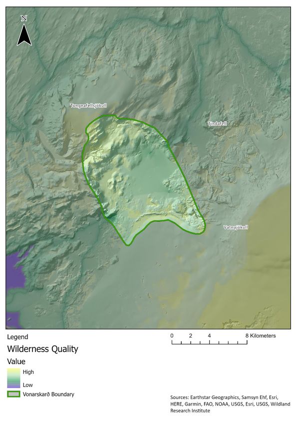
Vonarskarð 4x4 Hypothetical Access Route
Review of impacts on wilderness

Figure 1.2 Route of the previously open 4x4 access route

                                                    9
Vonarskarð 4x4 Hypothetical Access Route
 Review of impacts on wilderness

2. Defining wilderness and approaches to mapping
2.1 The Wilderness Register and Indicator for Europe report19 and associated mapping shows that the total area
of the top 1% wildest land across the whole of EU/EEA is 56,810km 2 of which 24,063km2 is found in Iceland.
Iceland accounts, in other words, for just over 42% of the top 1% wildest land in Europe. Although most of the
areas highlighted are Iceland’s numerous icecaps, this is a significant figure and includes significant areas of ice-
free land in the interior and remote coastal areas. Figure 2.1 shows the pattern of wilderness quality across
Iceland based on the indicator mapping in the 2013 EU Wilderness Register report.

Figure 2.1 Wilderness quality in Iceland (After Kuiters et al., 2013)

2.2 One of the stated objectives of the 2013 Nature Conservation Act No. 60/2103 20 which entered in to force
in November 2015, is to protect wilderness areas. The Act introduces the management objectives for wilderness
protected areas in Iceland as follows: "The protection should aim to safeguard the characteristics of the areas
e.g. to maintain diverse and unusual landscapes, panoramas and/or conserve complete large ecosystems, and
ensure that present and future generations can enjoy therein solitude and nature without disturbance from man-
made infrastructures or traffic from motor vehicles“21. This follows closely those objectives as stated in the IUCN
standards and guidelines for Category 1b Wilderness Areas which itself defines wilderness areas as: “Protected
areas that are usually large, unmodified or slightly modified areas, retaining their natural character and
influence, without permanent or significant human habitation, which are protected and managed so as to
preserve their natural condition” (Dudley, 2013, p. 14). Article 5 of the Nature Conservation Act 2013 provides
some basic numeric criteria to help highlight potential wilderness areas in Iceland. These are: “An area of
uninhabited land that is in principle at least 25 km 2 in size or so that one can enjoy solitude and nature without
disturbance from man-made structures or the traffic of motorized vehicles and in principle at least 5 km away
from man-made structures and other evidence of technology, such as power lines, power stations, reservoirs and

19
   Wilderness register and indicator for Europe Final report 2013 (draft) Contract N o:
07.0307/2011/610387/SER/B.3
https://ec.europa.eu/environment/nature/natura2000/wilderness/pdf/Wilderness_register_indicator.pdf
20
   https://www.althingi.is/lagas/nuna/2013060.html
21
   Jóhannsdóttir, Aðalheiður (2016) “Wilderness Protection in Iceland“ in Kees Bastmeijer (ed.) Wilderness
Protection in Europe. The Role of International, European and National Law pp 370.

                                                         10
Vonarskarð 4x4 Hypothetical Access Route
Review of impacts on wilderness
elevated roads”22. These criteria are guidelines intended to highlight potential wilderness areas and not regarded
as absolute thus giving rise to the need for more robust mapping approaches 23.
Wilderness protection is also mentioned within the new National Planning Strategy (Landsskipulagsstefna) that
was adopted by a Parliament Resolution in March 2016 24. This states that: “The Planning Agency and the
Environment Agency are responsible for regularly updating maps of the extent and development of wilderness in
the central highlands. This includes setting criteria for assessing the extent of the wilderness based on planning
considerations and having regularly updated maps on the extent of the wilderness accessible to the planning
work of local and other parties“. This currently applies to the central highlands region25, of which Vonarskarð is
part, but will now be expanded to other wilderness areas of Iceland in the future, as per a mandate given by the
Minister for the Environment and Natural Resources to the Planning Agency in 2018 and the proposal put
forward to the Parliament in 2021 for a revised National Planning Strategy 26,27 .
2.3 The connection between physical attributes such as terrain, size, distance and vegetation with how people
perceive wildness in the landscape is key to the successful mapping of wilderness. Most wilderness mapping
programmes use combinations of perceived and biophysical (ecological) attributes of wilderness to describe the
patterns and variations in wilderness quality across a target landscape. While there is no one single and
universally accepted method, these mapping programmes tend to focus on measures of naturalness (e.g. how
natural the landscape and its ecology is) and remoteness (e.g. how large an area is and how remote places are
from human settlement, roads and other infrastructure). Different countries may modify and adjust the
measures and attributes used to define wilderness in a manner that best suits their landscape and culture. The
work presented here follows closely that developed for Scotland. This has been used and successfully applied at
both a local (national park)28,29 and national scale to support protected area planning and to identify planning
boundaries for the protection of wild land areas30. While they are different countries, Iceland and Scotland share
certain biophysical and geographical similarities in terms of size, openness and low vegetation with limited
forest/woodland cover wherein both landscapes are rugged, mountainous, sparsely populated with a remote
interior, limited road access and a wild coastline.
2.4 It is recognised that there are differing opinions about wilderness within the Icelandic landscape and that
there is no direct translation of the English word “wilderness”. The large remote areas of the central highlands
have traditionally been referred to as uninhabited areas or óbyggðir, but more recently the idea of wilderness
22
Revised and updated translation from Jóhannsdóttir, Aðalheiður (2016) “Wilderness Protection in
Iceland“, in Kees Bastmeijer (ed.) Wilderness Protection in Europe. The Role of International, European and
National Law pp 367. The original legal text refers to roads as being elevated (uppbyggðir) rather than main
roads. The legal text also mentions power lines as an example. Furthermore, the wording of this provision of
the Nature Conservation was slightly amended in 2020.
23
See the four proposed criteria in draft revised National Planning Strategy, put forward to the Parliament
April 2021, at Subsection 6.1.6, 1184/151 stjórnartillaga: endurskoðuð landsskipulagsstefna 2015--2026 |
Þingtíðindi | Alþingi (althingi.is) )
24
https://www.skipulag.is/en and https://www.landsskipulag.is/english/ and Chapter 1.1
https://www.landsskipulag.is/media/pdf-skjol/Landsskipulagsstefna2015-2026_asamt_greinargerd.pdf
25
https://www.landsskipulag.is/gildandi-stefna/afmorkun-midhalendisins/
26
https://www.landsskipulag.is/ferlid/tillaga-i-vinnslu and
https://www.landsskipulag.is/media/landsskipulagsstefna-vidbaetur/Landsskipulagsstefna-
vidb_brefradherra.pdf
27
Endurskoðuð landsskipulagsstefna 2015–2026 | Þingmálalistar | Alþingi (althingi.is)
28
“Wildness study in the Cairngorms National Park” Report prepared for the Cairngorms National Park
Authority and SNH, September 2008. https://wildlandresearch.org/wp-
content/uploads/sites/39/2018/10/Cairngorm2008.pdf
29
“Wildness study in Loch Lomond and The Trossachs National Park” Report prepared for the Loch Lomond
and The Trossachs National Park Authority and SNH, January 2011. http://www.lochlomond-
trossachs.org/park-authority/publications/wildness-study/
30
National Planning Framework 3: The third National Planning Framework, setting out a long-term vision for
development and investment across Scotland over the next 20 to 30 years. Scottish Government 2014.
https://www.gov.scot/publications/national-planning-framework-3/
11Vonarskarð 4x4 Hypothetical Access Route
Review of impacts on wilderness
as applied to Icelandic landscapes and the word víðerni has come into more common use. Regardless, the
preparatory work to the existing Nature Conservation Act makes a clear reference to the English term
“wilderness” and IUCN management category Ib.
2.5 The physical attributes to be used in the identification of wilderness are expanded on in the table 2.1. This
table lists both the main (physical) criteria used to describe these attributes, but also gives further interpretation
of these regarding how they are likely to influence people's perceptions of wildness in the landscape setting.
These are derived and adapted from the SNH Wildness in Scotland’s Countryside policy statement (2002) which
form the basis for the successful mapping of wild land in Scotland. While the 2002 SNH policy statement provides
the basis for subsequent mapping work, it does not provide the exact methodology, rather an indication that
the approach adopted might be based on a "simple scoring system" such as has been used successfully in the
development of the Australian National Wilderness Inventory 31 and the Human Footprint/Last of the Wild32. As
such SNH supported two feasibility studies based around mapping wildness in the Scottish National Parks and,
in recognising the difficulties surrounding varied perceptions of wildness and the interpretation of physical
attributes, also supported two public perception surveys, one in 2007 (reporting in 2008)33 and one in 2011
(reporting in 2012)34.
2.6 The Scottish national wildness map has been developed by SNH based on an up-scaling of the National Parks’
methodology. This has inevitably involved some modifications. These are outlined briefly below and the
differences in respect to the original National Park mapping highlighted. The SNH approach has been to map
wildness in three phases:
● Phase 1: An equally weighted multi-criteria GIS mapping of those physical attributes of wildness as
defined in the 2002 SNH policy document based on practical interpretations of how these attributes
affect people's perceptions of wildness to map spatial variations and patterns in wildness on a relative
scale from least wild to most wild. This essentially mirrors the methodology and techniques developed
for mapping wildness in the two National Parks by WRi with some minor modifications to the data used
and resolution to allow up-scaling across the whole of the country. These mainly concern the use of
coarser resolution models and the omission of selected datasets which would have been difficult to
source and/or validate at the national scale.
● Phase 2: A statistical classification and grouping areas from the resulting Phase 1 map based on Jenks
Natural Breaks Optimisation to define areas with high levels of wildness according to all four attributes
and application of differing size thresholds north and south of the Highland Boundary Fault. This differs
from the National Parks’ mapping only in that a different statistical method is used to arrive at the
classification of the wildness areas. In the National Park mapping, classifications for the Phase 1
wildness quality map was performed using fuzzy classification techniques 35.
● Phase 3: A simplification of the GIS-derived mapping in Phase 1 and 2 using lines drawn at 1:50,000
scale to align the wilderness area boundaries with recognisable features on the ground such as rivers,
lochs, ridges, etc. and take into account local features and recent development consents. This phase is
similar to that used by the two Scottish National Park authorities whereby the defined boundaries of
wild areas are informed by the Phase 1 and 2 mapping and the additional expert knowledge of Park
staff.
31
National Wilderness Inventory's Handbook of Procedures, Content and Usage, Second Edition, May 1995
32
Sanderson, E. W., Jaiteh, M., Levy, M. A., Redford, K. H., Wannebo, A. V., & Woolmer, G. (2002). The Human
Footprint and the Last of the Wild. BioScience, 52(10), 891-904.
33
SNH Commissioned Report No.291 Public Perceptions of Wild Places and Landscapes in Scotland
(ROAME No. F06NC03) James Fenton Scottish Natural Heritage.
34
Public Perception Survey of Wildness in Scotland. Report for Loch Lomond & The Trossachs National Park
Authority, Cairngorms National Park Authority & Scottish Natural Heritage in Association With Research Now
July 2012.
35
Comber, A., Carver, S., Fritz, S., McMorran, R., Washtell, J., & Fisher, P. (2010). Evaluating alternative
mappings of wildness using fuzzy MCE and Dempster-Shafer in support of decision making. Computers,
Environment and Urban Systems, 34(2), 142–152.
12Vonarskarð 4x4 Hypothetical Access Route
Review of impacts on wilderness
2.7 The final map of wilderness areas was published in June 2014 along with the final SPP2 and NPF3 documents.
A total of 42 wilderness areas are identified covering just under 20% of the land area of Scotland. All the maps
and details of the mapping process and underpinning policy documents can be found on the SNH web pages 36.
2.8 Phase 1 and 2 of the Scottish national wildness mapping approach are adapted here to fit Icelandic data
sources and environmental conditions. This is best suited to mapping patterns and variations in wilderness
quality in Iceland based on similarities with northwest Scotland and previous experience with applying these
approaches elsewhere and in Iceland itself. Data collection, processing and model development is described in
detail in sections 3 and 4 of this report. Results from the mapping of wilderness quality in the Vonarskarð are
presented in section 5 and the implications discussed in section 6.
36
SNH Mapping Scotland's wildness and wild land http://www.snh.gov.uk/protecting-scotlands-
nature/looking-after-landscapes/landscape-policy-and-guidance/wild-land/mapping/
13Vonarskarð 4x4 Hypothetical Access Route
Review of impacts on wilderness
Table 2.1 Physical attributes in the identification of wild land (After SNH, 2002)
Attributes Main criteria Further detail
Perceived Vegetation cover primarily composed of Habitat may often not be in best condition or
naturalness functioning, natural habitats. at optimum ecological status. But there will
normally be potential for recovery, and the
vegetation cover should be composed of
Catchment systems largely unmodified, and other natural components. Some small plantations
geomorphological processes unaffected by land may be tolerated especially at the edge of an
management. area, if they are the only detracting feature and
of limited effect on wildness.
Lack of No contemporary or recent, built or engineering Older features (fences, bridges, stalking tracks,
constructions or works within the area. or small buildings may be present, if not
other artefacts intrusive overall.
Archaeological features (normally a light
Little impact from out with the area on wild
imprint on the land) will contribute to visitors’
qualities from built development, power lines, or
appreciation of the continuity of human use of
masts or other intensive land uses (say forestry),
these areas. Some intrusive features (say
or from noise or light pollution.
vehicular tracks which partly penetrate into an
area) may be tolerated, where their effects are
limited, and where excluding such land would
Limited effects on the wild qualities of the area reject an area of high intrinsic quality.
from older artefacts.
Little evidence of Extensive range-grazing and field sports (as The cumulative effects of the economic uses of
contemporary economic uses of the land) will often be present, the land should not be intrusive.
land uses as well as public recreation.
Evidence of muirburn or over-grazing, habitat
Land uses of an intensive nature should not be management, footpath deterioration and
present. erosion, or the effects of the use of off-road
vehicles may be visible. But the effects of any
one of these activities, or their cumulative
expression should not be of a scale or intensity
so as to significantly devalue visitors’
perceptual experience.
Rugged or Striking topographic features, or land having Different kinds of terrain can offer an inspiring
otherwise extensive rough terrain or extensive bog lands, or challenging experience for people but, in the
Challenging difficult to traverse. main, it is those landscapes which are of
terrain arresting character (by virtue of the scale and
Natural settings for recreational activities
form of the terrain) which are most valued for
requiring hard physical exercise or providing
their wildness.
challenge.
Remoteness and Distance from settlements or modern Distance is not an absolute guide on its own,
inaccessibility communications. but most of the wild land resource will lie in the
remaining remote areas, as defined by distance
Limited accessibility, either by scale of the area,
from private and public roads and other
difficulty in passage, or the lack of easy access, say
artefacts.
by vehicular tracks, bridges, or by boat.
Extent of area An area of land sufficient to engender a sense of Smaller areas of land of high intrinsic merit or
remoteness; to provide those who visit them with inaccessibility can hold the qualities which
physical challenge; and to allow for separation underpin a sense of wildness, say an
from more intensive human activities. inaccessible rocky gorge, and the same applies
to some small uninhabited islands, or stretches
of isolated coast.
14Vonarskarð 4x4 Hypothetical Access Route
Review of impacts on wilderness
3. Developing a wildness model
3.1 Maps of the four attributes of wildness – perceived naturalness of land cover, remoteness from mechanised
access, absence of modern human artefacts, and ruggedness - can be combined to produce a series of wildness
maps for the Vonarskarð area using the MCE and fuzzy methods developed and used in previous studies 37,38,39,40
including Drangar Peninsula41. MCE methods allow the combination of predefined and standardised attribute
layers (criteria) describing the relative merits of a solution or location using a set of user-defined weights to
describe the relative importance or priorities assigned to each input layer. This process is illustrated as a flow
chart in Figure 3.1.
3.2 The model illustrated in Figure 3.1 needs to be populated by attribute maps derived from raw data and a
set of weights reflecting the relative importance of the attributes in defining the overall wildness map. The
attribute maps are prepared from the interpretation of raw spatial data such that they represent the
components of wildness derived from SNH policy and applied here to the Vonarskarð area with adaptations to
suit Icelandic data and landscape conditions. These are described in detail in section 4. Attribute weights can be
defined either numerically (e.g. Carver et al., 2002) or using fuzzy methods (e.g. Fritz et al., 2000). The weights
allocated to each of the attribute maps can be defined in consultation with the partners and local stakeholders
using appropriate perception surveys. The exact detail of the hypothetical re-opening of the 4x4 route is unclear
but is likely to follow the approximate route of the previously existing track between the two roadhead car
parks42. Several different wildness maps are produced as part of this study using MCE and fuzzy methods to
reflect the likely conditions and scenarios associated with the hypothetical re-opening of the 4x4 route in order
to take different scenarios into account. A wildness map that combines each of the four attribute maps using
equal weights is produced and used as a benchmark reflecting current conditions. These wildness maps indicate
the perceived wildness using a continuous scale rather than discrete areas. The current pattern in the variation
of wilderness quality across the Vonarskarð area is shown in Figure 3.2.
3.3 Care needs to be taken during this process to ensure that the input attribute maps do not exhibit a high
degree of spatial correlation such that one particular theme does not dominate the results. For example, it is
conceivable that the remoteness and ruggedness might be closely correlated in the core mountain areas away
from the main valley routes. Checks are performed to make sure attribute maps are not correlated and to flag
up any possible problem areas where spatial correlations are found to exist (see section 4.5).
3.4 All map layers need to be standardised (normalised) onto a common relative scale to enable cross
comparison. For example, remoteness and perceived naturalness are measured using time (minutes) and
nominal naturalness class, and so cannot be directly compared. In addition, the “polarity” of individual map
37
Carver, SJ. "Integrating MCE with GIS-modelling urban system." International Journal of Information System
5 (1991): 321-339.
38
Fritz, Steffen, Steve Carver, and Linda See. "New GIS approaches to wild land mapping in Europe." In In:
McCool, Stephen F.; Cole, David N.; Borrie, William T.; O’Loughlin, Jennifer, comps. 2000. Wilderness science in
a time of change conference—Volume 2: Wilderness within the context of larger systems; 1999 May 23–27;
Missoula, MT. Proceedings RMRS-P-15-VOL-2. Ogden, UT: US Department of Agriculture, Forest Service, Rocky
Mountain Research Station. p. 120-127, vol. 15. 2000.
https://www.fs.fed.us/rm/pubs/rmrs_p015_2/rmrs_p015_2_120_127.pdf
39
Carver, Steve, A. J. Evans, and Steffen Fritz. "Wilderness attribute mapping in the United Kingdom."
International Journal of Wilderness 8, no. 1 (2002): 24-29. http://eprints.whiterose.ac.uk/934/1/evansaj7.pdf
40
Carver, Steve, Alexis Comber, Rob McMorran, and Steve Nutter. "A GIS model for mapping spatial patterns
and distribution of wild land in Scotland." Landscape and Urban Planning 104, no. 3-4 (2012): 395-409.
https://lra.le.ac.uk/bitstream/2381/27733/2/7_carver_et_al_LUP.pdf
41
Hvalá power plant proposal: review of impacts on wilderness: a report
https://rafhladan.is/handle/10802/28566
42
Baldursson, Trausti, and Magnússon, Borgþór. Umsögn um Vonarskarð. Náttúrufræðistofnun Íslands. (2019).
https://www.ni.is/sites/default/files/atoms/files/uttekt_um_vonarskard.pdf
15Vonarskarð 4x4 Hypothetical Access Route
Review of impacts on wilderness
layers needs to be maintained such that higher values in the standardised maps are deemed to be “better” (i.e.
indicative of greater wildness). Standardisation of the attribute maps is achieved here using a linear re-scaling
of the input values onto a 0-255 scale on an equal interval basis and lower values are “worse” (i.e. indicative of
lower wildness). The weights applied to the map layers are defined on an equal weighted basis for the purposes
of this report. These are then applied within a simple Weighted Linear Combination MCE model within the GIS.
Alternative wildness maps are created to demonstrate the influence of different weighting schemes on the
results. These alternative weighting schemes and resulting wildness maps are described in section 5.
3.5 Weighted Linear Combination is simply based on the sum of the weighted standardised map layers as
follows:
i=n
Sij = (WijXij )
ij
where S = suitability of the choice alternative (site or grid cell), W = criterion weights, X = standardised criterion
score, i = ith choice alternative, j = jth criteria.
3.6 The equal weightings option weighs all of the components of wildness equally so that there is no implied
difference in importance attached to any of the four wilderness attributes. There are several reasons for doing
this. Firstly, under the assumption of equal salience, where all four components are deemed to be equally as
important, it provides an objective unbiased approach. Secondly, the data from any future perception survey
would need to be interpreted in order to be used as these are likely to show cognition bias where unfamiliar
terms are less well supported than familiar ones by survey respondents. The equal weighting option for the
overall wildness map is therefore in this case a more reliable approach.
Figure 3.1 Flow chart showing how the data are parameterised by weights and combined to generate a wildness
map
16Vonarskarð 4x4 Hypothetical Access Route
Review of impacts on wilderness
Figure 3.2 Current patterns of wildness in the Vonarskarð area
17Vonarskarð 4x4 Hypothetical Access Route
Review of impacts on wilderness
4. Attribute maps
4.1 The four attributes of wildness as defined by SNH (2002)43 are modified for Icelandic wilderness and mapped
using a combination of readily available datasets and the latest GIS-based techniques. These attribute maps are
produced for the Vonarskarð area. The immediate area outside of the defined Vonarskarð area is mapped to
ensure that there are no edge effects arising from visible human features and points of access immediately
outside the Vonarskarð area. These are described in turn, together with the data used, the method of mapping
and associated caveats and assumptions. The following descriptions are based on and closely follow those
developed for the assessment of impacts on wildness from the proposed Hvalá hydro power plant and
associated infrastructure in the Drangar Peninsula44.
Perceived naturalness of land cover
4.2 Perceived naturalness of land cover is described here as the extent to which land management, or lack of it,
creates a pattern of vegetation and land cover which appears natural to the casual observer. Perceptions of
wilderness are in part related to evidence of land management activities such as fencing, improved pasture and
stocking rates, as well as presence of natural or near-natural vegetation patterns. Here the Nytjaland
/Landnýting 2016 datasets45 are brought together to best describe perceived naturalness in the Vonarskarð area.
Data sources
4.3 Aspects of land management are identifiable from national land cover datasets like Nytjaland. These
datasets are available from the Kortavefsjá Landbúnaðarháskóla Íslands 46. The distribution, presence and
absence of features related to wilderness can often be inferred from their classes and relative positions.
4.4 Previous work by Carver (2005)47 and Carver et al. (2008)48 has based naturalness of land cover on a
reclassification of the LCM201549, and the earlier products, into a smaller number of naturalness classes. The
land cover classes from the Nytjaland were reviewed with local experts for ground truthing and then were
applied to equivalent naturalness classes. The naturalness classes used here are shown in table 4.1.
Method
4.5 The Nytjaland land cover map, re-projected at a nominal resolution of 20m to match other data in the overall
model, is reclassified into 5 naturalness classes based on similar classifications used by SNH as shown in Table
4.1. To account for the influence that the pattern of land cover in the area immediately adjacent to the target
location has upon perceived naturalness of a certain grid cell, the mean naturalness class is calculated for each
location within a 250m radius neighbourhood. This value is then assigned to the target cell to represent the
overall naturalness score for that location. Edge effects are avoided by calculating perceived naturalness for the
whole Vonarskarð area. The resulting attribute map is shown in Figure 4.1.
43
SNH Policy Statement WILDNESS IN SCOTLAND'S COUNTRYSIDE Policy Statement No. 02/03
https://www.nature.scot/sites/default/files/2019-10/Wildness%20in%20Scotland%27s%20Countryside%20-
%20Policy%20Statement.pdf
44
Hvalá power plant proposal: review of impacts on wilderness: a report
https://rafhladan.is/handle/10802/28566
45
http://www.nytjaland.is/landbunadur/wgrala.nsf/key2/nytjaland.html
46
http://lbhi.maps.arcgis.com/apps/webappviewer/index.html?id=227b358de2ec4738b9d51c8e86457c0d
47
Carver, S. (2005) Opportunity Mapping for New Wildwoods: a report submitted to the North Pennines AONB
Partnership by the University of Leeds. University of Leeds.
48
Wildness study in the Cairngorms National Park. Report prepared for the Cairngorms National Park Authority
and SNH, September 2008. https://wildlandresearch.org/wp-
content/uploads/sites/39/2018/10/Cairngorm2008.pdf
49
Centre for Ecology and Hydrology Land Cover Map 2015 https://www.ceh.ac.uk/services/land-cover-map-
2015
18Vonarskarð 4x4 Hypothetical Access Route
Review of impacts on wilderness
Caveats and assumptions
4.6 The Nytjaland index data is known to suffer from some misclassification errors at a local scale on a cell-by-
cell basis. However, the dataset is considered here to be the best available basis for developing indicators of
naturalness for landscape scale studies in Iceland. The reclassification of the Nytjaland into 5 naturalness classes
from natural/semi-natural to improved and built on land is based on the subjective reading of the class
descriptions given in the dataset documentation. There is likely to be differing levels of naturalness within
Nytjaland land cover classes due to differing levels of impact (e.g. from hydro reservoirs) or topological
relationships with other land classes (e.g. bare rock and barely vegetated) that are not fully accounted for within
the data descriptions.
Absence of modern artefacts
4.7 Absence of modern human artefacts is considered here to refer to the lack of obvious artificial forms or
structures within the visible landscape, including roads, vehicle tracks, pylons, dams, buildings and other built
structures. The choice of which human features to include here is driven largely by what is understood to act as
a wilderness detractor based on SNH wild land policy (SNH, 2002), relevant sections of the perception survey
and what data is available. Previous work on the effects of human artefacts on perceptions of wilderness carried
out at national to global scales has tended to focus on simple distance measures 50,51,52. More recent work has
used measures of visibility of human artefacts in 3D landscapes described using digital terrain models53,54.This is
feasible at the landscape scale utilising viewshed algorithms and land cover datasets to calculate the area from
which a given artefact can be seen. Work by Carver (2007) 55 for the Nidderdale AONB has utilised cumulative
and distance weighted viewshed algorithms to give a more accurate impression of the spatial pattern of the
impacts of visible human artefacts on peoples’ perceptions of wilderness in guiding decisions about suitable
areas for regeneration of native woodland. A similar approach to that used for the SNH work is adopted here
using artefacts are deemed to have an impact on wilderness, together with more a digital surface model (DSM)
derived from ArcticDEM and a novel and rapid viewshed assessment method developed for the earlier
Cairngorm wildness mapping project (2008).
Data sources
4.8 Visibility analysis and viewshed calculations rely on the ability to calculate line-of-sight from one point on a
terrain surface to another. It has been shown that the accuracy of viewsheds produced in GIS is strongly
dependent on the accuracy of the terrain model used and the inclusion of intervening features (buildings,
woodland, etc.) or terrain clutter in the analysis (Fisher, 1993). The terrain data used here is the ArcticDEM 2m
resolution digital surface model (DSM) and derived digital terrain model (DTM). This data is derived from
DigitalGlobe Satellite Constellation imagery and is accurate to with -0.01 m ± 0.07 m56.
4.9 Modern human artefacts are extracted from the OSM buildings dataset57 or digitised manually. These are
divided into several discrete height classes using ground truth based on expert local knowledge.
50
Lesslie, R. (1993) The National Wilderness Inventory: wilderness identification, assessment and monitoring in
Australia. International wilderness allocation, management and research. Proceedings of the 5th World
Wilderness Congress. 31-36.
51
Carver, S. (1996) Mapping the wilderness continuum using raster GIS. in S.Morain and S.Lopez-Baros (eds)
Raster imagery in Geographic Information Systems. OnWord Press, New Mexico, 283-288.
52
Sanderson, E. W., Jaiteh, M., Levy, M. A., Redford, K. H., Wannebo, A. V. and Woolmer, G. (2002) The human
footprint and the last of the wild. Bioscience. 52(10): 891–904.
53
Fritz, S., Carver, S. and See, L. (2000) New approaches to wild land mapping in Europe. Proceedings of 15-
VOL-2 (2000) Missoula, Montana.
54
Carver, S. and Wrightham, M. (2003). Assessment of historic trends in the extent of wild land in Scotland: a
pilot study. Scottish Natural Heritage Commissioned Report No. 012 (ROAME No. FO2NC11A).
55
Carver, S. (2007) Regeneration of native woodland in the Nidderdale AONB. University of Leeds.
56
https://www.pgc.umn.edu/data/arcticdem/
57
https://www.openstreetmap.org/relation/299133
19Vonarskarð 4x4 Hypothetical Access Route
Review of impacts on wilderness
Method
4.10 The use of visibility analyses in GIS that incorporate both a DSM and feature data showing the location and
pattern of modern human artefacts allows the creation of cumulative viewsheds that can be weighted according
to artefact type and distance. These can be combined and used to describe the attribute layer showing the
relative effects associated with the presence and absence of human artefacts. These are applied in the
cumulative viewshed methodology. Bishop‘s (2002) 58 work on the determination of thresholds of visual impact,
and the SNH report on “Visual Assessment of Windfarms: Best Practice" (SNH, 2002) 59, were used to help define
the limits of viewsheds and the distance decay function used.
4.11 Viewshed analyses such as these are extremely costly in terms of computer processing time. Detailed
analyses can take weeks, months or even years to process depending on the number of human artefacts included
in the database. It is usual to reduce processing times by generalising the artefact database by aggregating the
number of human features in a cell of a given size. Work by Carver (2005 and 2007) used cell sizes of 500x500m
and 250x250m, respectively. Recent work by Washtell (2007) 60 has shown that it is possible to both dramatically
decrease the processing times required for GIS-based viewshed analyses and improve their overall accuracy,
through judicious use of a voxel-based landscape model and a highly optimised ray-casting algorithm.
4.12 While studies exist comparing the advantages of various optimised viewshed algorithms in their own right
(Kaučič and Zalik, 2002)61 as of yet few of these seem to have percolated through into proprietary GIS packages.
It is not clear whether the relative lack of sophistication of viewshed analyses sought within the Environmental
Sciences (usually restricted to calculating the visibility of a handful of point features), owes itself to limitations
in the pervading software, or whether the reverse is true. However, researchers in the domain have for some
time been pushing the capabilities of the available tools - for example, by refining workflows for producing
cumulative viewsheds (Wheatley, 1995)62.
4.13 The algorithm used herein, which is similar to those used in real-time rendering applications and in some
computer games, was designed to perform hundreds of traditional point viewshed operations per second. By
incorporating this into a custom-built software tool which has been designed to work directly with GIS data (see
Figure 4.2), it is possible to estimate the visibility between every pair of cells in a high-resolution landscape
model utilising only moderate computing resources. In this way, features of interest are no longer limited to a
finite collection of points, but any set of features which can be described by a GIS data layer. This approach
(called a ‘viewshed transform’) can be regarded as a maturation of traditional cumulative viewshed techniques.
It was chosen for this project owing to the complexity of the surface and feature layers involved and the
importance of applying methods that can realistically model the human perception of visual isolation in complex
terrain. Figure 4.2 shows the voxel viewshed transform software interface with both the DSM and feature layers
loaded (Figure 4.2a) and with an example inverse square distance weighted viewshed (Figure 4.2b).
4.14 The approach adopted here utilises the Arctic DEM and feature data extracted from the OSM data to:
● calculate a viewshed for every single human artefact;
● incorporate estimates of the proportional area of each artefact that is visible; and
● run separate viewshed calculations for each of the different categories of features listed above and
combine these to create the absence of human artefacts attribute map.
58
Bishop, I. (2002) Determination of thresholds of visual impact: the case of wind turbines. Environment and
Planning B. 29(5) 7070-718.
59
https://pdfs.semanticscholar.org/47b7/7e7fd1fb08fb00e05cdfb2bdd9379ce6e635.pdf
60
Washtell, J. (2007) Developing a voxel-based viewshed transform for rapid and real time assessment of
landscape visibility. Unpublished course Paper. MSc in Multi-disciplinary Informatics, University of Leeds.
61
Kaučič, B. and Zalik, B. (2002) Comparison of viewshed algorithms on regular spaced points. In Proceedings
of the 18th Spring Conference on Computer Graphics (Budmerice, Slovakia, April 24 - 27, 2002). SCCG '02.
ACM, New York, NY, 177-183. DOI=http://doi.acm.org/10.1145/584458.584487
62
Wheatley, D (1995), "Cumulative Viewshed Analysis: a GIS-based method for investigating intervisibility, and
its archaeological application", in G.Lock and Z.Stancic (eds.) Archaeology and GIS: A European Perspective. pp
171-185, London: Taylor & Francis.
20You can also read