Sandy Hook Alternative Access Concept Plan and Vehicle Replacement Study
←
→
Page content transcription
If your browser does not render page correctly, please read the page content below
National Park Service
U.S. Department of the Interior

Gateway National Recreation Area
Sandy Hook Unit
Fort Hancock, New Jersey

Sandy Hook
Alternative Access Concept Plan and Vehicle Replacement Study

PMIS No. 133841A
June 2009

John A. Volpe National Transportation Systems Center
Research and Innovative Technology Administration
U.S. Department of Transportation
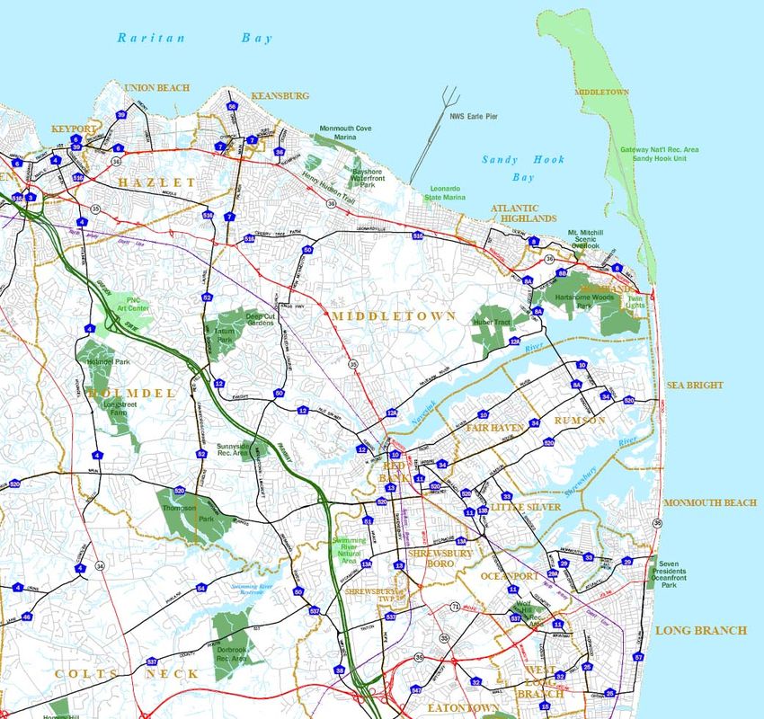
Table of Contents

Report Notes ........................................................................................................................ ii
Acknowledgments...............................................................................................................iii
Introduction..........................................................................................................................1
Site and Regional Context.................................................................................................... 2
Existing Conditions.............................................................................................................. 4
   Parking ........................................................................................................................................... 4
   Vehicular Traffic Inbound/Outbound from the Park ..................................................................... 6
   Route 36 Corridor Traffic Conditions ............................................................................................ 8
   Baseline Access Options to Sandy Hook.......................................................................................... 9
Fundamental Planning Parameters for Alternative Access Options to Sandy Hook ............11
Options for Alternative Access to Sandy Hook ................................................................... 12
   Option 1: New Ferry Service to Sandy Hook from Belford Ferry Terminal ................................. 12
       Belford Ferry Terminal...................................................................................................................... 12
   Option 1A: New Ferry Service to Sandy Hook from South Amboy Ferry Terminal ......................16
       South Amboy Ferry Terminal........................................................................................................... 16
   Option 2: NJ Transit Coordinated Train/Bus Shuttle Service to Sandy Hook ...............................19
       Red Bank Train Station..................................................................................................................... 19
   Option 3: Bus Shuttle from Conner’s Ferry Landing to Sandy Hook.............................................23
       Conner’s Ferry Landing .................................................................................................................... 23
   Option 4: Local Resident Bicycle Incentive Program and Connection of the Henry Hudson Trail
   to the Sandy Hook Multi-Use Pathway......................................................................................... 26
       Henry Hudson Trail ........................................................................................................................... 26
  Option 5: Redesign of the Henry Hudson Trail for Tram Operation ............................................ 29
Transportation Plan for Alternative Access to Sandy Hook ...............................................32
Cost Estimate of the Transportation Plan.......................................................................... 36
  Option 1: New Ferry Service from Belford Ferry Terminal ......................................................... 36
  Option 2: NJ Transit Coordinated Train/Bus Shuttle Service to Sandy Hook .............................. 36
  Option 4: Local Resident Bicycle Incentive Program and Connection of the Henry Hudson Trail
  to the Sandy Hook Multi-Use Pathway..........................................................................................37
Alternative Access Options Rejected...................................................................................38
The Intra-Park Shuttle – Ideas for Vehicle Replacement .................................................... 41
Next Steps ...........................................................................................................................45
References.......................................................................................................................... 47

Volpe Center Sandy Hook Alternative Access Concept Plan & Vehicle Replacement Study, June 2009                                                         i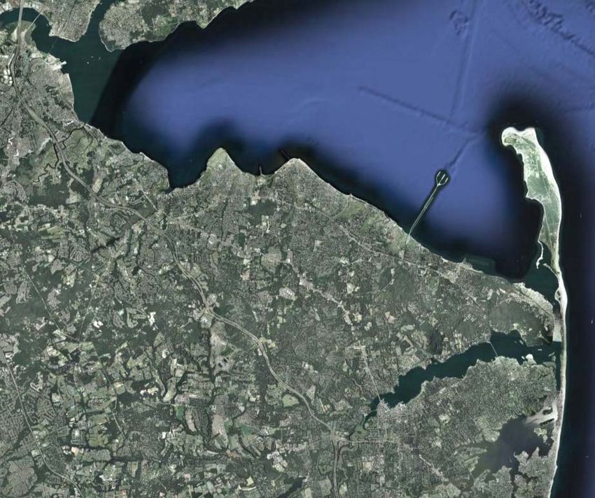
Report Notes
This report was prepared by the U.S. Department of Transportation John A. Volpe National
Transportation Systems Center, in Cambridge, Massachusetts. The project team was led by David Spiller
and Frances Fisher of the Systems Operations and Assessment Division.

This effort was undertaken in fulfillment of the statement of work included in the August 2008
interagency agreement between the National Park Service and the Volpe Center (NPS agreement
F4505087777).

Volpe Center Sandy Hook Alternative Access Concept Plan & Vehicle Replacement Study, June 2009          ii
Acknowledgments
The authors wish to thank the numerous organizations and individuals who graciously provided their
time, knowledge and guidance in the development of this report, including:

Sandy Hook Unit
David Avrin, Acting Superintendant
Hollis Provins, Acting Assistant Superintendent
Christine Slade, Fee Collection Supervisor
William Nelligan, Former Deputy Superintendent
Lou Venuto, Chief, Interpretation & Cultural Resources
Steven Grillo, Business Management & Permit Coordinator
Brian Forseth, Chief of Maintenance
Bruce Lane, Park Ranger

Gateway National Recreation Area
Mark Christiano, GIS Specialist

NY Waterways
Augie Pagnozzi

SeaStreak
Jim Barker, Owner
Kathy Mullin, Office Manager- Highlands Ferry Terminal

New Jersey Transportation Planning Authority (NJTPA)
Jeff Vernick, Senior Planner

Borough of Highlands
Anna Little, Mayor
Bruce Hilling, Town Administrator

Borough of Sea Bright
Maria Fernandes, Mayor

Fred Brody Associates
Fred Brody

Sandy Hook Foundation, Sandy Hook Friends Group
Betsy Barrett

Monmouth County Planning Department
Nora Shepard, Supervisory Planner
Joe Barris, Planner
Bonnie Goldschlag, Planner
Anthony Gamallo, Planner

Monmouth County Engineering Department
Joe Ettore, County Engineer

Monmouth County DOT
Henry Nicholson

Volpe Center Sandy Hook Alternative Access Concept Plan & Vehicle Replacement Study, June 2009       iii
Monmouth County Parks Department
Spence Wickham, Planning and Design
Faith Hahn, Planning and Acquisition

Monmouth County
Teri O’Connor, Deputy Administrator

New Jersey DOT
Pankesh Patel, Design Engineer

South Amboy Redevelopment Agency
Stan Marcinczyk

Academy Bus Lines
Joe Porcelli, Maintenance Manager

Jacobs Civil, Inc.
Robert Brakman, Manager Transportation Systems

US DOT/Volpe Center
Robert Hallett, GIS Specialist
Lindsey Morse, Community Planner

Volpe Center Sandy Hook Alternative Access Concept Plan & Vehicle Replacement Study, June 2009   iv
Introduction
This study addresses two critical issues of concern to the Sandy Hook Unit of Gateway National
Recreational Area: (1) options for alternative access to Sandy Hook during peak summer season,
particularly when the park is closed to private vehicles when parking facilities are full; and (2) options for
a replacement vehicle for the intra-park shuttle that carries passengers disembarking from the ferry to the
beaches.

Volpe Center Sandy Hook Alternative Access Concept Plan & Vehicle Replacement Study, June 2009               1
Site and Regional Context
The Gateway National Recreation Area (Gateway NRA), consisting of units at Staten Island, Sandy Hook,
and Jamaica Bay, offers some of the region’s most spectacular beaches; an internationally renowned
wildlife refuge; salt marshes; fishing areas; hiking trails; and a multiplicity of activities, cultural resources,
and educational services. The location of these resources amidst populous urban neighborhoods and
sprawling suburbs adds immeasurably to their value for area residents and visitors.

The Sandy Hook unit is located in Monmouth County, New Jersey, on a peninsula, approximately 1700
acres in size, extending north from coastal New Jersey at Sea Bright into the convergence of Raritan Bay,
Sandy Hook Bay, Lower New York Bay, and the Atlantic Ocean. The unit is the northern-most part of a
barrier beach that stretches south and includes the town of Sea Bright and is adjacent to a region known as
the Bayshore that consists of nine municipalities located along the coast of the Raritan Bay: Aberdeen,
Atlantic Highlands, Hazlet, Highlands, Keansburg, Keyport, Marlboro, Matawan, and Union Beach
(Middletown, Holmdel, and the Sandy Hook unit itself are also occasionally included in the region’s
definition).

The unit’s proximity to populous urban neighborhoods and inviting beaches results in severe roadway
and parking lot congestion during the summer season. On average, parking capacity is exceeded, resulting
in park closings, for 10-12 weekend days each summer. These closures typically last from 2-4 hours,
depending on the rate at which visitors exit the park and free up additional parking spaces. The lack of
parking and traffic congestion caused by park closings are serious problems during the summer season.
The primary method of assessing traffic congestion is to assign a letter grade (A through F) that describes
a roadway’s level of service (LOS). LOS measures the average vehicle delay at intersections, the speed of
traffic flow, and mobility between lanes. The conditions at Sandy Hook have been assessed at an LOS of F*
and have been identified as a serious congestion management issue for the region by Monmouth County’s
metropolitan planning organization. In addition, park staff have reported that these conditions greatly
contribute to visitor frustration and have resulted in road rage incidents both within the park and in
gateway communities along New Jersey State Route 36, the main corridor leading to the park.

Route 36 provides the major access route to Sandy Hook from the north, west, and from the south. The
highway meanders along a portion of New Jersey’s northeast shoreline between Long Branch to the south
and Keyport to the north. It provides several coastal communities with access to the Garden State
Parkway (GSP). At its northern and southern termini, Route 36 connects with GSP Exits 117 and 105,
respectively. The Route 36 Highlands Bridge, a bascule bridge currently being replaced with a fixed-span
bridge, provides a vital link across the Shrewsbury River for recreational, residential, and commercial
development located on the barrier island between Monmouth Beach and Sandy Hook. On the
Highlands, Route 36 is called Navesink Avenue and generally maintains an east-west alignment. On the
peninsula, the Route 36 alignment changes to a north-south orientation, and is called Ocean Avenue.
About two miles south of the Route 36 Highlands Bridge, Route 36 (Ocean Avenue) connects with
Monmouth County Road 520 and the Sea Bright-Rumson Bridge. The entire Route 36 corridor is part of
the planned evacuation route identified by the emergency management plan of the town of Sea Bright,
located on the barrier island.

*
    Sandy Hook – Route 36 Corridor Summer Traffic Management Plan, February 2001.
Volpe Center Sandy Hook Alternative Access Concept Plan & Vehicle Replacement Study, June 2009                   2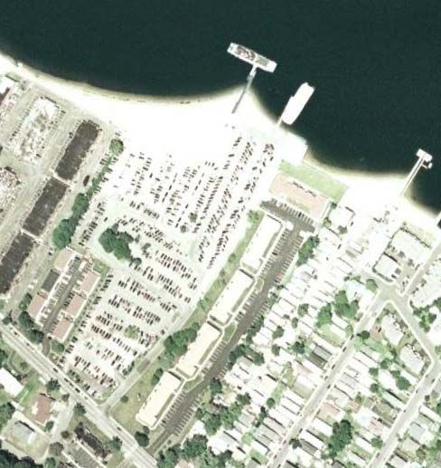
Figure 1
   Site and Regional Context
   Source:http://co.monmouth.nj.us/documents/24%5CMC%20WebMap.pdf

GSP
Exit
117

                                                                                                             Route 36 –
       Garden State                                                                                          Highlands
        Parkway                                                                                               Bridge
          (GSP)

                                                                                                               Route 36 –
                                                                                                              Ocean Drive

                                                               GSP Exit 105

            Volpe Center Sandy Hook Alternative Access Concept Plan & Vehicle Replacement Study, June 2009                3
Existing Conditions
Parking
Parking supply at Sandy Hook is the primary limiting factor in the number of vehicles able to be
accommodated in the Park. The Environmental Assessment for the Adaptive Use of Fort Hancock & the
Sandy Hook Proving Ground Historic District identifies a total supply of 4,926 parking spaces. The
resulting Finding of No Significant Impact (FONSI) document, a modified version of the environmental
assessment, limits the total number of spaces on Sandy Hook to 5,036. This number includes an additional
110 parking spaces distributed in six new lots within the Historic District. A recount of the parking spaces
in 2005 articulates a revised number at 4,819. These spaces are distributed as illustrated in Table 1 below.
Table 1
Number of Parking Spaces and General Location at Sandy Hook
General Location Number of Parking Spaces
Beaches and Bayside 4,085
Fort Hancock 519
NPS Operations 215
Total 4,819
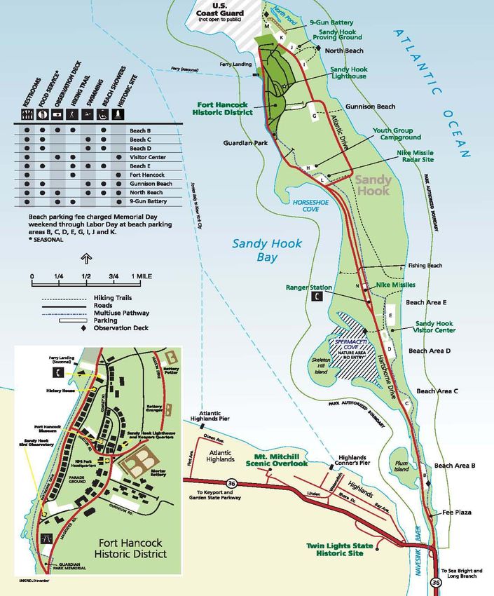
Table 2 illustrates the distribution of parking spaces along the beaches and bay; Figure 2 indicates where
these lots are located.
Table 2
Number of Parking Spaces by Parking Lot
Parking Lot Number of Parking Spaces
Parking Lot A (planned) N/A
Parking Lot B 330
Parking Lot C 293
Parking Lot D 785
Visitor Center 25
Parking Lot E 769
Ranger Station 12
Parking Lot N 24
Fishing Rd. (roadside) 25
Parking Lot L 33
Parking Lot H 17
Parking Lot G (Gunnison Beach) 781
Parking Lot I 341
Parking Lot J 250
Parking Lot K 400
Total 4,085
Volpe Center Sandy Hook Alternative Access Concept Plan & Vehicle Replacement Study, June 2009 4
Figure 2
Map of Parking
Source: “Planning Your Visit.” Gateway National Recreation Area website.
http://www.nps.gov/gate/planyourvisit/upload/Map%20of%20Sandy%20Hook%20peninsula.2008%20unigrid.pdf

          Volpe Center Sandy Hook Alternative Access Concept Plan & Vehicle Replacement Study, June 2009   5
There is a general sequence during which the individual lots are filled. Although approximate, these times
are: Lot G- 9:30, Lot C-10:00, Lot D – 10:30, Lot I – 11:30, Lot E -11:30, Lot B – 11:45, Lot J-11:45. When a
particular lot is full, signage on the road diverts traffic to the next upstream lot.
There is the potential for closing the park each weekend day and holiday of the summer season. In recent
years, the first closing happened the first weekend of June and the last closing occurred on Labor Day. On
average, a closing lasts approximately 2 hours any time between 11:00 AM and 2:30 PM. A decision to close
the park to vehicular traffic is based on the number of lots that are closed, the time-of-day, and the
inbound versus outbound (i.e., exiting) volume of traffic. Conversely, re-opening the park is based on the
number of parking spaces available and in which parking lots the available spots are located along with the
volume of exiting traffic. As a general rule, between 350-400 open spots is considered adequate before the
park can reopen. Lots are monitored once the park is reopened in case incoming traffic is heavy and the
park would need to be closed again.
Vehicular Traffic Inbound/Outbound from the Park
Average vehicular entry flows by day-of-week when there are no closure events are illustrated below in
Chart 1. Peak entry flow averages 650-675 vehicles per hour and peaks at ~ 10:00 AM on the weekends.
Chart 1
Average Entry Profile on Days with No Closures
Source: Data provided by Sandy Hook.
Average Entry Profile on Days with No Closures
800.0
700.0
600.0
500.0 Sunday
Number of Vehicles
Monday
Tuesday
400.0 Wednesday
Thursday
Friday
300.0 Saturday
200.0
100.0
0.0
1 2 3 4 5 6 7 8 9 10 11 12 13 14 15 16 17 18 19 2 21 22 23 24
Hour of Day
Volpe Center Sandy Hook Alternative Access Concept Plan & Vehicle Replacement Study, June 2009 6On Saturdays when the park experiences a closure event, peak entry flow averages 1100-1200 vehicles per
hour just prior to a decision to close the park. Closure duration then averages approximately 2-3 hours.
This is illustrated below in Chart 2.
Chart 2
Saturday Entries on Days with Closures
Source: Data provided by Sandy Hook.
Saturday Entries on Days with Closures
1400
1200
Number of Vehicles
1000
800
600
400
200
0
0 1 2 3 4 5 6 7 8 9 10 11 12 13 14 15 16 17 18 19 20 21 22 23
Hour of Day
7-Jun 12-Jul 19-Jul No Closure Avg
A similar graphic for Sunday closure events is illustrated in Chart 3.
Chart 3
Sunday Entries on Days with Closures
Source: Data provided by Sandy Hook.
Sunday Entries on Days with Closures
1400
1200
Number of Vehicles
1000
800
600
400
200
0
1 2 3 4 5 6 7 8 9 10 11 12 13 14 15 16 17 18 19 20 21 22 23 24
Hour of Day
8-Jun 13-Jul 3-Aug 17-Aug 31-Aug No Closure Avg
Volpe Center Sandy Hook Alternative Access Concept Plan & Vehicle Replacement Study, June 2009 7On summer weekends at Sandy Hook, vehicular flow exiting the park can jump to 800 vehicles per hour
between 3:00 PM and 5:00 PM (see Chart 4). In some cases, traffic exiting the park has caused significant
back-ups. Some of this may be relieved when the new bridge is completed as traffic will not be held by the
need to open the bridge for boat traffic.
Chart 4
Southbound Exits by Day of Week and Month
Source: Data provided by Sandy Hook.
SB Exits by Day of Week and Month
900
800
700
600 Jun-Wkdy
Jun-Sat
Number of Vehicles
Jun-Sun
500 Jul-Wkdy
Jul-Sat
400 Jul-Sun
Aug-Wkdy
Aug-Sat
300 Aug-Sun
200
100
0
1 2 3 4 5 6 7 8 9 10 11 12 13 14 15 16 17 18 19 2 21 22 23 24
Hour of Day
Route 36 Corridor Traffic Conditions
During the summer season, beach-destined traffic operates in the reverse direction to normal commuting
patterns, as can be seen in Figure 3. Relevant peak-period conditions in the reverse commuting direction
in the AM period (generally, from Garden State Parkway (GSP) junction with Route 36 eastbound to
Sandy Hook) during weekdays (M-F) indicate traffic volumes from 1,400 vehicles per hour (vph) to 550
vph at the bridge crossing, and level-of-service (LOS) equal to D – i.e., a moderate amount of vehicular
delay (greater than 35 and less than 55 seconds average delay per vehicle at the signalized intersections,
*
and stop-go traffic conditions along the road). In the PM weekday period, traffic volumes westbound in
the direction of GSP near the bridge crossing approximate 500 vph and rise to 1,600 vph near the junction
†
with GSP at Broad Street. In the evenings LOS equals C in the reverse commute direction along Route 36.
*
Je/Sverdrup & Parcel Consultants, Inc., Gateway Village Rehabilitation Project: Traffic Impact Study, 2003.
†
Ibid.
Volpe Center Sandy Hook Alternative Access Concept Plan & Vehicle Replacement Study, June 2009 8Figure 3
Route 36 Traffic Conditions: Peak Period Vehicles per Hour (vph)
To Sandy
Hook
1,600 vph
LOS C 500 vph
Highlands
Route 36 Bridge
1,400 vph LOS D 550 vph
Garden State
Parkway
(Exit 117)
AM Weekday Peak
PM Weekday Peak
Summer weekend through-trips along Route 36 to and from Sandy Hook National Recreation
Area and other shore points result in significant traffic congestion. In part, this congestion is due to traffic
demand exceeding available capacity at the key bottlenecks (the series of signalized intersections along
the route), to disruptions to the traffic flow from the periodic (twice per hour) opening of the Highlands
Bridge over the Shrewsbury River, and to park closure events when the park is forced to stop accepting
vehicular traffic when the parking capacity limit is reached. When parking lots are full, cars are turned
away and become backed up along significant lengths of Route 36. Homebound traffic on weekend
afternoons and evenings is also very heavy along Route 36 as travelers head toward the Garden State
Parkway.
Baseline Access Options to Sandy Hook
The primary mode of access to Sandy Hook is by private vehicle. Although precise numbers are not
available, staff at Sandy Hook indicate that approximately 85% of the visitors arrive via Route 36
eastbound, many who have come off of the Garden State Parkway at Exit 117. The other approximately
15% of visitors arrive via Monmouth County Road 520 and Route 36 northbound through Sea Bright and
Ocean Avenue (Route 36 north).
For the last 10 years, ferry service has been operated from New York City (East 35th Street and pier 11 in
Manhattan) to Sandy Hook, docking at the northern end of the peninsula in the Fort Hancock historical
district. At the docks, visitors either walk to the beaches or transfer to an intra-park shuttle that provides a
distributor service to/from the beaches and historic sites. Table 3 below summarizes the history of New
York City-Sandy Hook ferry service.
Volpe Center Sandy Hook Alternative Access Concept Plan & Vehicle Replacement Study, June 2009 9Table 3
History of Ferry Service – Sandy Hook
Source: Provided by Sandy Hook.
New Jersey Transit (NJ Transit) has two bus routes (834 and 835) that operate in proximity to Sandy Hook
but that do not enter the park. Route 834 connects the Red Bank Rail Station to Highlands via
Middletown (including the Rail Station), Belford, Atlantic Highlands and Route 835 connects the Red
Bank Rail Station to Sea Bright. These buses run approximately hourly on weekdays and Saturdays only.
Walking conditions along the main access points to the park are poor. For example, while it is possible to
walk along Route 36/Ocean Avenue from Sea Bright into Sandy Hook, the walking facility consists of a
narrow (2’ or less) shoulder. Similarly poor conditions exist between the Highlands central business
district, the Highlands Bridge, and Sandy Hook. The lack of safe and convenient pedestrian facilities, the
distances to destinations, and the desire of most people to bring many accessories to the beach makes
walking an unlikely access option for most visitors.
Experienced bicyclists accustomed to sharing a vehicular travel lane (or riding along the edge at the edge
line of the shoulder) can currently access the beaches at Sandy Hook, particularly when they connect to
the Sandy Hook Multi-use Pathway (MUP). The Highlands Bridge Design Review Committee has been
assiduous and successful in assuring adequate pedestrian and bicycle facilities across the newly
reconstructed Highlands Bridge – with a direct connection to the MUP. Monmouth County also is
fortunate to have its own multi-use paved path – the Henry Hudson Trail. Originally extending from
Aberdeen to Avenue D in Atlantic Highlands, the trail has been extended on the southern end to Freehold
and on the northern end from Avenue D to Poporama Point. There are plans to provide on-street bicycle
facilities from Poporama Point to the reconstructed Highlands Bridge, thus providing direct access to
Sandy Hook. As Option 4 in the Options for Alternative Access section below indicates, the existence of
the Henry Hudson Trail (with the future planned connection to Sandy Hook) provides a tremendous
opportunity to increase the significance of bicycle access to Sandy Hook.
Volpe Center Sandy Hook Alternative Access Concept Plan & Vehicle Replacement Study, June 2009 10Fundamental Planning Parameters for Alternative Access Options to
Sandy Hook
It is clear from the analysis of visitation patterns at Sandy Hook – informed also by extended discussions
with stakeholders and park staff at the on-site visit - that the prime operating season for new transit and
ferry services is from Memorial Day through Labor Day on Saturdays and Sundays (plus Memorial Day,
Fourth of July and Labor Day).
There are two fundamental markets. First, visitors (primarily from Manhattan) who come to Sandy Hook
without a car; secondly, visitors with a car who are susceptible to diversion to staging areas for transfer to
other modal options for relief from congestion or for satellite parking as they drive along the Route 36
corridor.
Success factors for the first market (non-drivers) are:
Ability to exploit the availability of NJ train service from NYC to the Route 36 corridor because it
penetrates the heart of NYC (with large access shed) and the interior of Monmouth County on an
exclusive right-of-way (ROW) absent of congestion
Schedules that are consistent with when visitors want to arrive at Sandy Hook and when they
want to depart from Sandy Hook
Coordinated transfers between train service and either ferry or bus services so that visitors have
zero wait and the connections are seamless
Pricing that matches the ability and willingness to pay for the service
Success factors for the second market (drivers) are:
Identification of a sizeable parking area for transfer to bus or ferry service
Short diversion off of Route 36 corridor to staging area, and local streets that can handle
additional volume of traffic
Way-finding signage system to staging areas for alternative access
Frequent bus or ferry service at staging area to Sandy Hook so wait and transfer times are
tolerable
Pricing consistent with entry fee at Sandy Hook and consistent with ability and willingness to pay
by this market
Volpe Center Sandy Hook Alternative Access Concept Plan & Vehicle Replacement Study, June 2009 11Options for Alternative Access to Sandy Hook
Option 1: New Ferry Service to Sandy Hook from Belford Ferry Terminal
Belford Ferry Terminal
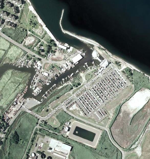
One of the major regional transportation assets is the Belford Ferry Terminal. The site consists of
approximately 10 acres of land situated in the vicinity of Compton’s Creek and Sandy Hook Bay in the
Township of Middletown. The County of Monmouth owns and operates the ferry facility, and has made
physical infrastructure improvements – including construction of a ferry terminal, waterfront bulkhead
and pedestrian walkways, parking facility (~ 1000 parking spaces), and pier and docks (see Figure 4
below). Future plans call for some additional parking (~ 200 spaces), but the amount is limited by both
wetland issues and local neighborhood opposition to any large-scale expansion.
Figure 4
Belford Ferry Terminal
Source: Google Earth
The County has entered into a contractual agreement with New York Waterways* to provide ferry service
between Belford Ferry Terminal and Manhattan, with landing sites at New York City’s terminal at Pier 11
in proximity to Wall Street in lower Manhattan; at NY Waterways’ terminal at Battery Park City in
proximity to the World Financial Center; and at NY Waterways’ terminal at West 38th Street and the
Hudson River in midtown Manhattan. Service is provided weekday, Monday-Friday, to service the
commuter market, with at least three (3) trips during the peak periods (5:30 AM-11:00 AM; and 4:00 PM to
8:00 PM). Over time, the service has become quite successful, with parking at saturation or capacity each
weekday.
*
Official name: Port Imperial Ferry Corp (PIFC) d/b/a NY Waterways
Volpe Center Sandy Hook Alternative Access Concept Plan & Vehicle Replacement Study, June 2009 12Of critical importance to the viability of this option, the agreement between the County and NY
Waterways provides that the County reserves the right, and the right to allow others the right, to use the
*
Belford Ferry Terminal for other purposes including the provision of ferry services to other destinations.
A concept for new ferry service from Belford Ferry Terminal is illustrated in Figure 5 and described
below.
Figure 5
Option 1: New Ferry Service to Sandy Hook from Belford Ferry Terminal
Source: Google Maps (modified by the Volpe Center)
Belford Ferry Terminal and ferry route
Garden State Parkway Exit 117 and vehicular access to ferry
Access
Market segment served: Sandy Hook visitors arriving from Northern New Jersey via private
vehicle
Private vehicular access via GSP Exit 117 to Route 36 Eastbound, exit off of Route 36 on Main
Street in Belford to Terminal Road
Shared use of already existing extensive surface parking (~ 1,000 parking spaces) during time
when unoccupied for modal transfer to the ferry service
*
Ferry Service and Landing Agreement By and Between: County of Monmouth and Port Imperial Ferry Corp., dated October 30,
2000, at Section 5. Granting of Landing Rights, p. 4
Volpe Center Sandy Hook Alternative Access Concept Plan & Vehicle Replacement Study, June 2009 13 Ferry terminal structure for shelter and ticket processing available
Short diversion path off of GSP (6.25 miles, ~11 minutes) and Route 36: (~ 1 mile)
Service Structure
Ferry distance and one-way transit time to Sandy Hook: approximately ~ 5.28 miles and 14
minutes*
Operating season: Saturday, Sunday and holidays from Memorial Day through Labor Day
Static and dynamic (VMS) message signs would be needed on the GSP and along Route 36 prior
to the diversion exit to Belford Ferry Terminal. A minimum of three signs (of each type) are
needed at varying distances before the decision point to divert to Belford Ferry Terminal.
Guidelines for site placement and message design should comply with such guidelines for
highway interchange signage.
Once a decision is made to close Sandy Hook, the park closure event should extend to well
beyond the peak exit rate from the park (~ 5:00 PM) in order to provide an inducement to visitors
to use alternative ferry access as the sole means of access to Sandy Hook, and to increase the
willingness-to-pay by visitors who arrive to the Route 36 corridor after the initial closure event.
This would also reduce cruising behavior on the part of motorists – a major contributor to
congestion within the corridor.
Benefits
Distance and time avoided by private vehicles on the lower part of the Route 36 corridor where
extensive traffic backups form: ~7 miles and ~ 42 minutes
Potential Opposition
Possible local opposition and concerns for intensive use of Belford Ferry Terminal on the
weekends
Possible conflict with fishing vessels in channel leading to Sandy Hook Bay
Local access on Main Street could be problematic on weekends due to limited capacity, and
residential character of abutting land use. Table 4 illustrates existing traffic conditions at the
intersection of Route 36 and Main St., the access road to Belford Ferry Terminal.
*
Assumes 20 knot vessel speed.
Volpe Center Sandy Hook Alternative Access Concept Plan & Vehicle Replacement Study, June 2009 14Table 4
Weekend Evening Traffic Levels – at Route 36 & Main Street, Middletown, NJ
Source: JE/Sverdrup and Parcel Consultants, Inc., Gateway Village Rehabilitation Project: Traffic Impact Study, 2003.
Traffic Volume to Delay Level of Service
Direction Lane Capacity Ratio (seconds) (LOS)
Left Turn 0.91 93 F
Northbound
Thru/Right Turn 0.62 42 D
Left Turn 0.52 58 E
Southbound
Thru/Right Turn 0.76 49 D
Eastbound Thru 0.72 29 C
Westbound
Thru/Right Turn 0.54 25 C
Management Issues
Three primary steps are needed to initiate new service to Sandy Hook from Belford: (1) MOU or
agreement drafted between and among Monmouth County (who owns the facility), NY
Waterways (the current primary operator), and possibly a secondary ferry operator who would
operate the new service; (2) A 30-day public comment period (and outreach to the local
community); (3) A resolution drafted and voted on by the Board of Freeholders (which meets
twice a month) to legally authorizes the initiation and operation of the new ferry service to Sandy
Hook from Belford Ferry Terminal.
NY Waterways is the existing and primary operator out of Belford; a secondary operator such as
SeaStreak would have to pay landing right fees at Belford to NY Waterways ($0.10 per passenger
per trip). Conversely, if NY Waterways chooses to operate the new ferry service, it would have to
pay landing right fees (estimated at ~ $294 per operating day*) to SeaStreak, which currently owns
and operates the barge at Sandy Hook. Transfer of responsibility for ownership and management
of docking infrastructure at Sandy Hook (post-2009) could change the cost of landing right fees.
For example, a policy of zero-cost to vessel operators providing public access to Sandy Hook
could be adopted.
Financials
Estimates for operating costs were received from both SeaStreak† and NY Waterways‡ but
differed in level of detail and differed in value due to differences in cost structure, service plans,
and the vessel deployed. The estimated operating cost per round-trip ranged from $1,000-1,500,
approximately seventy (70) percent of which could be attributed to fuel cost, and estimated per-
person round-trip fare (assuming full cost recovery from the fare) could range from $12.50-20§
(variation due to load factor, passenger capacity, and other characteristics of service mentioned
above).
*
Personal communications, Terri O’Connor/Deputy Administrator, Monmouth County
†
Personal communications, J. Barker, SeaStreak; vessel costs assume crew manning consistent with larger 400-passenger capacity
vessel typically operated by SeaStreak for commuter ferry service from the NJ Bayshore to Manhattan .
‡
Personal communications, Augie Pagnozzi, NY Waterways; vessel costs assume 149-passenger capacity.
§
Percent load factor assumption varied from 20 to 75 percent and vessel passenger capacity ranged from 149 to 400.
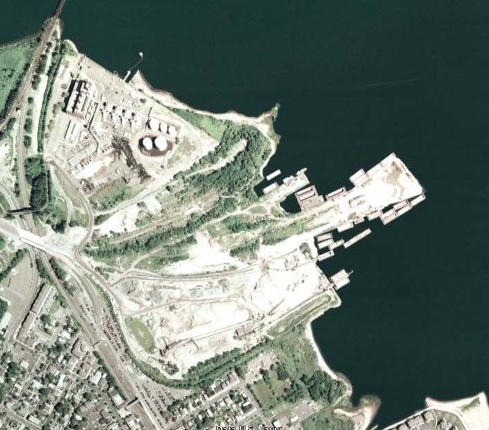
Volpe Center Sandy Hook Alternative Access Concept Plan & Vehicle Replacement Study, June 2009 15Option 1A: New Ferry Service to Sandy Hook from South Amboy Ferry
Terminal
South Amboy Ferry Terminal
Figure 6
South Amboy Ferry Terminal
Source: Google Earth
Through leveraging more than $100 million in federal, state and local funds (including substantial
investments by NJ Transit in elevated platforms and ADA accessibility), South Amboy has revitalized its
main street, transit station and ferry terminal. New bridge, road and parking infrastructure has been built
or will be completed by summer 2009, facilitating access and egress to the ferry terminal off of the Garden
State Parkway. The area proximate to the NJ Transit rail station and to the Ferry terminal has been
designated by NJ DOT as a Transit Village. Substantial mixed-use development has been built or is
planned for the area. The Transit Station is served by the NJ Transit Coast Line, with major origination
points at Newark Penn Station and Penn Station in Manhattan. Current surface parking approximates
600-650 spaces, and there are plans to expand parking by an additional 450 parking spaces. Although
South Amboy is primarily concerned with re-establishing commuter ferry service to Manhattan (~ 42
minute transit time via ferry), the docks can accommodate up to three (3) vessels concurrently, and could
support new service to Sandy Hook. Furthermore, new service to Sandy Hook on weekends and holidays
during summer season would not conflict with ferry service to Manhattan which would be Monday-
Friday only.
A concept for new ferry service from South Amboy Ferry Terminal is illustrated in Figure 7.
Volpe Center Sandy Hook Alternative Access Concept Plan & Vehicle Replacement Study, June 2009 16Figure 7
Option 1A: New Ferry Service to Sandy Hook from South Amboy Ferry Terminal
Source: Google Earth (modified by the Volpe Center)
South Amboy Ferry Terminal
South Amboy Train Station
Exit 125, Garden State Parkway
Access
Market segment served: Sandy Hook visitors arriving from Northern New Jersey via private
vehicle or transit
Private vehicular access via GSP Exit 125 to Chevalier Avenue to Main Street, South Amboy:
approximately < 1 miles or ~ 2 minutes
NJ Transit train and bus (local) connections to the South Amboy Ferry Terminal
Shared use of already existing extensive surface parking (~ 600-650 parking spaces) during
time when unoccupied for modal transfer to the ferry service; plans to expand parking (~ 450
spaces maximum) subject to Army Corps of Engineers and NJ DEP permit approvals and
conditions
Ferry terminal structure for shelter and ticket processing to be completed in summer 2009
Volpe Center Sandy Hook Alternative Access Concept Plan & Vehicle Replacement Study, June 2009 17Service Structure
Ferry distance and one-way transit time to Sandy Hook: approximately ~ 14.1 miles, and 38
minutes*
Operating season: Saturday, Sunday and Holidays from Memorial Day through Labor Day
Static and dynamic (VMS) message signs would be needed on the GSP and along State Route
9 prior to the diversion exits to South Amboy Ferry Terminal. Signs along the Route 36
corridor may be necessary as well. A minimum of three signs (of each type) are needed at
varying distances before the decision point to divert to South Amboy Ferry Terminal.
Guidelines for site placement and message design should comply with such guidelines for
highway interchange signage.
Once a decision is made to close Sandy Hook, the park closure event should extend to well
beyond the peak exit rate from the park (~ 5:00 PM) in order to provide an inducement to
visitors to use alternative ferry access as the sole means of access to Sandy Hook, and to
increase the willingness-to-pay by visitors who are driving along GSP prior to the exit to
South Amboy Ferry terminal after the initial closure event. This would also reduce cruising
behavior on the part of motorists – a major contributor to congestion within the Route 36
corridor – provided signs redirected visitors along the Route 36 corridor to South Amboy
Ferry terminal.
Benefits
Distance and time avoided by private vehicles on the Route 36 corridor where extensive
traffic backups form: ~14 miles and ~ 65 minutes
Financials
Estimated ferry operating cost per round-trip is ~ $2,700, seventy (70) percent of which is
attributed to fuel cost.† Per person round-trip fare (assuming full cost recovery from the fare)
is estimated at $34.‡
Management Issues
South Amboy Redevelopment Authority would negotiate and draw up agreement; South
Amboy Council would ratify agreement
If an operator other than SeaStreak were to provide the service, an agreement would need to
be implemented for the use of SeaStreak’s docking infrastructure at Sandy Hook for the 2009
season.
*
Assumes 20 knot vessel speed.
†
Based on data provided by SeaStreak out of Belford, scaled to reflect the greater distances from South Amboy – particularly with
respect to fuel costs which are distance-dependent. Assumes larger 400-passenger vessel. As a benchmark, new service between
South Amboy and Manhattan (~ 42 minute transit time) operating with 150-passenger vessels is expected to be priced at $26 per
person round-trip.
‡
Assumes the vessel utilization is low and averages only 20 percent load factor per round trip.
Volpe Center Sandy Hook Alternative Access Concept Plan & Vehicle Replacement Study, June 2009 18Option 2: NJ Transit Coordinated Train/Bus Shuttle Service to Sandy Hook
Red Bank Train Station
A major asset to the New Jersey Bayshore and Route 36 communities is that NJ Transit operates a very
high frequency commuter rail service via the NJ Transit Circle Line, serving stops at both Middletown
and Red Bank in reasonable proximity to Sandy Hook. The NJ Transit Circle Line connects both major
metropolitan areas of Newark, New Jersey (Newark Penn Station) and NYC (NYC Penn Station) to this
*
area. Train arrivals and departures at Red Bank Station are hourly on Saturdays, Sundays and Holidays .
The missing element – which this option proposes – is a connection to Sandy Hook and its beaches via a
weekend bus shuttle, coordinated with train arrivals and departures at Red Bank train station. A new
reservation system operated by NJ Transit would guarantee a seat on both the train and connecting bus
shuttle. Buses would ‘meet’ each train arrival and departure. The fares would reflect the combined
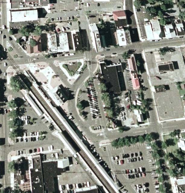
operation. Figure 8 below illustrates the location of Red Bank train station and its peripheral parking
facilities. All of the parking spaces in lots 1-5, and 8 are free on Saturdays and Sundays – a total of 455
parking spaces. There are an additional 339 parking spaces in lot 9 – but currently a parking charge is set
($10/hour). With proper VMS signage on the Garden State Parkway, and with the sizeable capacity for
parking at the Red Bank train station, this option could also serve the market consisting of visitors who
arrive via private vehicle and who still wish to access Sandy Hook when the park is closed to private
vehicles – with diversion off of the GSP at Exit 109 to Red Bank train station, then transfer to a bus shuttle
for access to the beaches at Sandy Hook.
Figure 8
Parking Lots around Red Bank Train Station
Source: NJ Transit website (http://www.njtransit.com)
Figure 9 illustrates the proposed loading zone and circulation pattern for buses serving Red Bank Station
and providing access and connectivity to Sandy Hook. The buses at Red Bank train station would collect
visitors who arrive at the train station (via train or private vehicle), then distribute them to the various
*
See schedules at http:// www.njtransit.com
Volpe Center Sandy Hook Alternative Access Concept Plan & Vehicle Replacement Study, June 2009 19beaches at Sandy Hook. On the return trip, the buses would pick up visitors at the beaches, and then bring
them back to the train station.
Figure 9
Proposed Loading Zone and Circulation Pattern at Red Bank Train Station
(with several parking lots from Figure 8 identified)
Source: Google Earth (modified by the Volpe Center)
Shuttle
Loading Zone
1
Red Bank
8
Train Station
2
3
A concept for new shuttle service from the Red Bank Train Station to Sandy Hook is illustrated in Figure
10 and described below.
Volpe Center Sandy Hook Alternative Access Concept Plan & Vehicle Replacement Study, June 2009 20Figure 10
Option 2: NJ Transit Coordinated Train/Bus Shuttle Service to Sandy Hook
Source: Google Earth (modified by the Volpe Center)
Red Bank Train Station and NJ Transit Long Branch Line
Proposed Bus Shuttle to Sandy Hook
Access
Market segments served: primary market NYC and Newark (visitors who do NOT bring a car to
the area); secondary market comprises visitors on the GSP willing to divert to Red Bank train
station for modal transfer to a bus shuttle directly to the beaches at Sandy Hook
Arrivals and departures hourly between 6:00 AM and 1:00 AM to/from Red Bank Station and
NYC Penn Station and Newark Penn Station
Transit time from NYC Penn Station and from Newark to Red Bank train station: 1:14 and 0:56 (h:
mm)
Diversion distance on GSP between Exit 117 (for Route 36) and Exit 109 (for County Route 520 to
Red Bank Station) is ~ 5 miles
Free parking on weekends and holidays (455 parking spaces)
Service Structure
Weekend service provided 9am-8pm, Memorial Day through Labor Day on Saturdays and
Sundays (plus Memorial Day, Fourth of July and Labor Day).
Round-trip per passenger fare from NYC Penn Station and from Newark: $20.00 and $14.50
respectively
Volpe Center Sandy Hook Alternative Access Concept Plan & Vehicle Replacement Study, June 2009 21 Transit time from NYC Penn Station and from Newark to North Beach at Sandy Hook: ~ 2:15 and
2:00 (h: mm)
Routing for bus shuttle from Red Bank Train Station: Monmouth Street • Broad Street • Harding
Road • Brand Avenue • Rumson Road • Shrewsbury River (Rumson) Bridge • Ocean Avenue
Local street congestion can be severe on summer weekends so bus shuttle transit time
approximates 1 hour to North Beach at Sandy Hook (~ 15 miles one-way). This breaks down as
follows*: Red Bank train station to the Rumson Bridge: ~ 15 minutes; transit time to cross bridge
based on ~ 1 mile queue backup is ~ 20-25 minutes; Rumson Bridge to North Beach at Sandy Hook
is approximately 20-25 minutes
Minimum requirement of two (2) buses to operate hourly service to/from Red Bank Train Station
in coordination with the hourly schedule for train arrivals and departures
*
Personal communications, Betsy Barrett/Friends of Sandy Hook
Volpe Center Sandy Hook Alternative Access Concept Plan & Vehicle Replacement Study, June 2009 22Option 3: Bus Shuttle from Conner’s Ferry Landing to Sandy Hook
Conner’s Ferry Landing
SeaStreak operates out of Conner’s Ferry Landing in Highlands, NJ. While SeaStreak still operates service
on weekends to Manhattan, including running several trips for baseball events on Saturdays and Sundays,
there is still substantial residual parking capacity to stage new bus shuttle service to Sandy Hook. One
advantage of this option is that visitors already committed to the Route 36 corridor bound for Sandy
Hook can be diverted to Conner’s Ferry Landing for transfer to a bus shuttle with properly sited VMS
signage sited along the Route 36 corridor. When the park is closed, this option would provide the sole
means of access to Sandy Hook and is likely to induce more visitors in private vehicles to divert rather
than cruise along Route 36 for access to other beaches in Sea Bright or to look for a turnaround in an
attempt to reenter Sandy Hook. Vehicular backups over the Shrewsbury River Highlands Bridge are a
concern for bus access to Sandy Hook, but the distance between Conner’s Ferry Landing and the access
ramp to the Highlands Bridge via Shore Drive is relatively short. At the other end of the Highlands Bridge,
law enforcement already in place would allow the bus shuttle access to the exit ramp to Sandy Hook
during park closure events (similarly to how law enforcement already provides access to park vehicles).
The greatest delay is the time to transit the Highlands Bridge.
Figure 11
Conner’s Ferry Landing
Source: Google Earth
A concept for a bus shuttle from Conner’s Ferry Landing to Sandy Hook is illustrated in Figure 12 and
described below.
Volpe Center Sandy Hook Alternative Access Concept Plan & Vehicle Replacement Study, June 2009 23Figure 12
Option 3: Bus Shuttle from Conner’s Ferry Landing to Sandy Hook
Source: Google Earth (modified by the Volpe Center)
Conner’s Ferry Landing and ferry route to Manhattan
Proposed Bus Shuttle to Sandy Hook
Garden State Parkway Exit 117 and vehicular route to Conner’s Ferry Landing
Access
Market segment: visitors arriving by private vehicle already committed to Sandy Hook within the
Route 36 corridor who can divert to a bus shuttle for access to Sandy Hook beaches, primarily
during park closure events
Access distance from the Route 35/36 junction is ~ 11 miles, but 60-75 minutes during congested
traffic conditions
Diversion distance < 1 mile
Residual parking capacity at Conner’s Ferry landing available for modal transfer to the bus shuttle
equal to ~500 parking spaces (free)
Service
Bus shuttle routing: Shore-Drive • Bay Avenue • access ramp to Shrewsbury Highlands Bridge •
exit ramp to Sandy Hook • Hartshorne Drive at Sandy Hook (serving all beach areas)
Bus shuttle provides both distributor and collector service at Sandy Hook beaches from/to
Conner’s Ferry Landing
Volpe Center Sandy Hook Alternative Access Concept Plan & Vehicle Replacement Study, June 2009 24 Operating service span would be 8 hours – between 11:00 AM (1st dispatch from Conner’s Ferry
landing) – 7:00 PM (last dispatch from North Beach at Sandy Hook) on weekends and holidays
only between Memorial Day and Labor Day
Bus shuttle roundtrip distance is ~ 14 miles, and approximately 1 hour (< 30 minutes to desired
beach for visitor)
Minimum of three (3) buses required to provide 20-minute frequency of service at Conner’s Ferry
Landing
Properly sited (at least three) VMS signs along Route 36 critical to success of this option
Financials
Per person round-trip fare (assuming full cost recovery from the fare) could approximate $8*
*
This assumes the NJ Transit cost per vehicle-hour equal to $129, and an operating service span of 8 hours and 2 hours dead-head. It
also assumes that there are three (3) buses in service, and that the average load is equal to 75 percent of seated capacity (i.e., 30
passengers) over 6 of the 8 hours in the operating service span.
Volpe Center Sandy Hook Alternative Access Concept Plan & Vehicle Replacement Study, June 2009 25Option 4: Local Resident Bicycle Incentive Program and Connection of the
Henry Hudson Trail to the Sandy Hook Multi-Use Pathway
Henry Hudson Trail
Another major regional asset is the Henry Hudson Trail. The Henry Hudson Trail is a paved multi-user
path – walkers, hikers, and bicyclists – that lies along the old NJ Central Railroad right-of-way (ROW).
The graphic below illustrates the northern portion. The ROW is a variable width of 40-80 feet, and the
paved path is 10-feet wide except along boardwalks over wetlands, where the width is 6-feet. There are at
least four trailhead parking areas, but parking is limited (~ 20 parking spaces per location). The northern
portion currently runs between Aberdeen/Keyport and Atlantic Highlands, with the segment between
Avenue D and Popamora Point having been completed in spring 2009. The northern portion generally
parallels the Route 36 corridor and has the potential to offer scenic, congestion-free bicycle access to
connect with the multi-user path (MUP) at Sandy Hook that runs the length of the Sandy Hook peninsula
(~ 6 miles one-way). The Bridge Design Committee for the reconstruction of the Highlands Bridge has
assiduously and successfully sought to modify the design to include wide bicycle lanes on the
reconstructed bridge, with a direct connection via a flyover to the Sandy Hook MUP, thereby facilitating
the proposed connection.
Figure 13
Map of Northern Portion of Henry Hudson Trail
Source: Monmouth County Park System website (http://www.monmouthcountyparks.com)
Option 4 below proposes to realize this potential by (1) accelerating plans to extend the terminus of the
northern segment from Popamora Point in Atlantic Highlands to the reconstructed Highlands Bridge; and
(2) develop an incentive program to use the Henry Hudson Trail for bicycle access to Sandy Hook for
local residents of Monmouth County via a reverse fee or rebate program.
A concept for connecting the Henry Hudson Trail to the park’s MUP is illustrated in Figure 14 and
described below.
Volpe Center Sandy Hook Alternative Access Concept Plan & Vehicle Replacement Study, June 2009 26Figure 14
Option 4: Local Resident Bicycle Incentive Program and Connection of the Henry Hudson Trail to the Sandy
Hook Multi-Use Pathway
Source: Monmouth County Planning Board, Bayshore Region Strategic Plan, 2006.
Henry Hudson Trail (Northern Portion)
Missing Connection
Sandy Hook Multi-Use Pathway
Proposal
Accelerate plans and develop design drawings for both the off-road and on-road segments of the
missing link between Popamora Point in Atlantic Highlands and the Shrewsbury River Highlands
Bridge. (At this point, no formalized planning process with public involvement is in place). Secure
funding and program the project in the Northern New Jersey Transportation Planning Authority
(NJTPA) Transportation Improvement Program (TIP).
Conduct a reutilization/revitalization land-use study of parcels adjacent to or in the proximity of
the northern segment of the Henry Hudson Trail to determine whether additional vehicular
parking facilities and a bicycle concession/repair facility could be sited and developed as an
amenity to the trail
Implement local resident (Monmouth County) registration and incentive program
o Local residents would join the program by registering their bicycles and attaching a bar
code sticker to the bicycle
o Sandy Hook Ranger would scan the sticker on arrival via bicycle at entrance station and
on exit from the park
Volpe Center Sandy Hook Alternative Access Concept Plan & Vehicle Replacement Study, June 2009 27o Provided the duration (calculated by the two time stamps) exceeds three (3) hours (to
prevent abuse of the program), a reverse payment (e.g., $5) would be handed to the
bicyclist upon exiting the park
o Program would be restricted to local residents only
Benefits
Every three (3) visitors who arrive via bicycle reduce the demand for vehicular parking by one (1)
car – leaving these parking spaces available for visitors originating from more distant locations
Most reasonably fit bicyclists can bicycle 10-12 miles per one-way trip - ~ 60 minutes; this places
much of the northern segment of the Henry Hudson Trail and penetration into Sandy Hook to
North Beach or beaches closer to the entrance station within reach
A bicycle speed ~ 10-12 mph is competitive with congested vehicular speeds within the Route 36
corridor – as well as being more enjoyable and healthy for the visitor
Although speculative, a monetary incentive to local residents to bicycle into the park via the
Henry Hudson Trail and Sandy Hook MUP could induce 100-300 persons to use this option for
access to Sandy Hook on a busy summer weekend
Volpe Center Sandy Hook Alternative Access Concept Plan & Vehicle Replacement Study, June 2009 28Option 5: Redesign of the Henry Hudson Trail for Tram Operation
The northern (eastern) segment of the Henry Hudson Trail could, as part of a long-range vision and plan,
conceivably also serve as an exclusive transit guide way within the congested Route 36 corridor, providing
alternative access to Sandy Hook and its beaches. Unlike the other options presented, it is premature to
consider all the implementation and feasibility considerations for this option, as it is intended to be a
long-term plan for further consideration in the future.
This option proposes a new paved 18’ tram path adjacent to the re-aligned existing trail and within the
existing right-of-way (ROW) limits (which vary between 40-80’). The tram path could support an electric,
rubber-tired tram consisting of a power unit with multiple trailing units. A schematic showing both plan
and elevation is illustrated below. There is good national precedent (over 60 trails in the nation) in
combining rail or transit line operations with a multi-use trail for walkers, runners, hikers and bicyclists
*
within the same ROW limits or corridor. Good planning and design is essential however to make this
concept work well. For this option, two other factors warrant that serious consideration is given to this
proposal: (1) the electric rubber-tired tram would have low impact (noise and emissions) and low speed (~
20 mph); (2) there would be vertical separation between the multi-use trail and the tram path, buffered by
landscape. Preservation of views to Sandy Hook Bay would be secured for both paths. This concept is
illustrated in Figure 15 and described below.
*
See, e.g., Rails-to-Trails Conservancy, Rails with Trails: Design, Management, and Operating Characteristics of 61 Trails Along Active
Rail Lines, November 2000. Also see US Department of Transportation, Rails-with-Trails: Lessons Learned. Literature review,
Current Practices, Conclusions, August 2002.
Volpe Center Sandy Hook Alternative Access Concept Plan & Vehicle Replacement Study, June 2009 29Figure 15
Schematic of Option 5: Redesign of the Henry Hudson Multi-Use Trail for Tram Operation
Source: U.S. DOT Volpe Center
Proposed Multi-use Trail
Existing Multi-use Trail with Tram Path
Landscape
buffering
Schematic
View from Trail
Elevation Cross
Section
Proposal
Staging area for modal transfer to the electric rubber-tired tram would be at Belford Ferry
Terminal (with large tract of vehicular parking)
Electric tram (see Figure 16 below) would connect via local streets to the Henry Hudson Trail
Majority of running would be on exclusive ROW (without congestion and parallel to Route 36
corridor)
At terminus of (new) off-road segment of the Henry Hudson Trail, electric tram would be routed
via local streets and Highlands Bridge to Sandy Hook Visitors Center (not too deep into the park)
Volpe Center Sandy Hook Alternative Access Concept Plan & Vehicle Replacement Study, June 2009 30where it would connect to expanded intra-park shuttle for distributor service to the various
parking lots and beaches
Transit time to the Visitor Center at Sandy Hook from Belford Ferry Terminal via the Henry
Hudson Trail tram ‘track’ would be ~ 40 minutes (including delays at the Highland Bridge). A
twenty (20) minute frequency of service would require four (4) tram units (each tram unit
consisting of a power unit and trailing unit). Passenger flow capacity in one direction is equal to
176 passengers per hour (44 passenger capacity per tram unit).
Potential Opposition
Complicated environmental and engineering issues would have to be resolved
Monmouth County Parks and Recreation Department and local residents would be adamantly
opposed unless the design solves the complicated environmental and engineering issues, is low-
impact and so visually appealing (including landscaping that separates the two paved paths, and
elevation differences that preserve the view shed from the original path) that users of the adjacent
bicycle/walking/jogging trail are NOT disturbed or their experience deteriorated
Benefits
During off-season (i.e., non-summer season), the two paved paths could resolve existing user
conflicts by shifting bicycles to the tram ‘track’ and using the original path for walkers and joggers
only.
Figure 16
Electric Tram
Source: ISE Corporation ThunderVolt brochure (http://www.isecorp.com).
Volpe Center Sandy Hook Alternative Access Concept Plan & Vehicle Replacement Study, June 2009 31You can also read