U tic oad - 2018 edition - Wisconsin Department of ...
←
→
Page content transcription
If your browser does not render page correctly, please read the page content below
Rustic Roads

                                                  2018 edition

wisconsindot.gov/rusticroads   CO N T E N T S   INDEX   M AP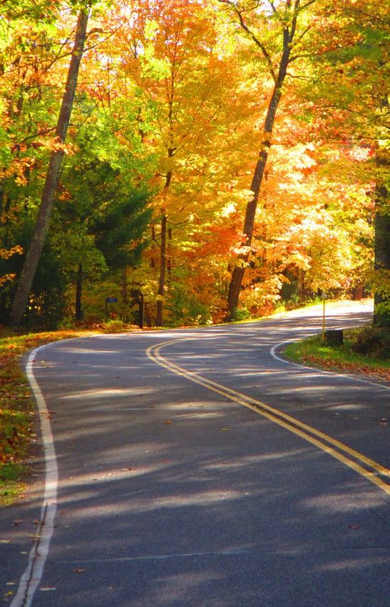
wisconsindot.gov/rusticroads
Governor’s Message
                      Most of Wisconsin’s roads are a means
                      to move people or goods safely and
                      efficiently. Rustic Roads, in contrast, are
                      the destination, offering you an excuse to
                      slow down and stop to enjoy the view.

                      Over 40 years old and still growing, the Rustic
                      Roads program helps preserve lightly traveled
country roads with outstanding natural features. Motorists, bicycle
riders, hikers and motorcyclists all share these scenic routes.

To help you find your way on these roads less traveled, WisDOT has
created both print and online guides to provide you with the most
up-to-date route information. The online digital formats link you
to additional resources and interactive maps to enhance your trip.

Many thanks to the Rustic Road photo contest winners and
participants for submitting photos, many of which are used
in this guide. They provide an inviting glimpse of the beauty
that awaits you on your future journey. As you create your
own photo memories, we invite you to share them using
#RusticRoads or @WisconsinDOT in your social media posts.
Have many safe and enjoyable trips!
Scott Walker, Governor

                         Rustic Road 34, Forest County, Edward J. DeBano

COV E R      CO N T E N T S     INDEX         M AP                         1
Rustic Roads
Contents
What is a Rustic Road?                                                          3
Rustic Road Index                                                               4
Rustic Road Locator Map                                                         5
Southwest                                                                       6
Southeast                                                                      17
Northwest                                                                     52
Northeast                                                                      74
Rustic Roads Board                                                            96
Program Contact                                                               96
The Wisconsin Rustic Roads Guide is published by the
Wisconsin Department of Transportation, in cooperation
with the Rustic Roads Board.
Front cover photo: Rustic Road 110, WisDOT photo
Inside front cover photo: Rustic Road 29, Walworth County, Sue J. Boyd
Inside back cover photo: Along Rustic Road 20, Dane County, Phyllis Kenseth
Back cover photo: Rustic Road 60, Vilas County, J. H. Arnold
Click on an item in the Table of Contents listing to go to its page.
On the Rustic Road index/map (pages 4–5), click on Rustic Road name to go to its page.
This guide is updated as new Rustic Roads are added to the program.
To print this PDF guide, do so on an 8.5 by 11 inch paper, selecting the "portrait" and
"actual size" settings for best results. Because this is a large document, consider
printing the single pages of interest to you.

wisconsindot.gov/rusticroads                                                        2
What is a Rustic Road?
                         The Rustic Roads system in Wisconsin
                         was created by the 1973 State Legislature
                         in an effort to preserve Wisconsin’s scenic,
                         lightly traveled country roads for the leisurely
                         enjoyment of bikers, hikers and motorists.

                         To qualify for the Rustic Roads program,
                         a roadway must have outstanding natural
features along its borders. These might include rugged terrain,
native vegetation and wildlife or open areas with agricultural
vistas that make the road unique. The road should be a lightly
traveled, public access road. It should not be scheduled for major
improvements which would change its rustic characteristics.
A Rustic Road may be a dirt, gravel or paved road. It should be at
least two miles long with a maximum speed limit of 45 mph.

Unique brown and yellow signs mark the routes of all
officially designated Rustic Roads. Each road is numbered.
To avoid confusion with the state highway number, a letter
“R” prefix is used with the number—such as R-50 or R-120.

                        Rustic Road 115, Waukesha County, Mary E. Yahle

COV E R      CO N T E N T S     INDEX          M AP                         3
Rustic Road Index Keep track of your visits. Check them off as you go! ROAD PAGE ROAD PAGE ROAD PAGE ROAD PAGE R-1 52 R-31 8 R-61 89 R-91 15 R-2 17 R-32 79 R-62 59 R-92 65 R-3 53 R-33 26 R-63 35 R-93 66 R-4 53 R-34 79 R-64 11 R-94 45 R-5 18 R-35 27 R-65 36 R-95 67 R-6 54 R-36 28 R-66 12 R-96 46 R-7 74 R-37 29 R-67 60 R-97 91 R-8 75 R-38 80 R-68 37 R-98 67 R-9 76 R-39 81 R-69 38 R-99 15 R-10 19 R-40 82 R-70 13 R-100 68 R-11 19 R-41 57 R-71 60 R-101 68 R-12 20 R-42 29 R-72 39 R-102 46 R-13 55 R-43 30 R-73 61 R-103 69 R-14 20 R-44 83 R-74 89 R-104 47 R-15 55 R-45 58 R-75 14 R-105 70 R-16 21 R-46 84 R-76 62 R-106 48 R-17 77 R-47 85 R-77 90 R-107 70 R-18 56 R-48 31 R-78 91 R-108 71 R-19 22 R-49 32 R-79 62 R-109 92 R-20 22 R-50 33 R-80 63 R-110 48 R-21 6 R-51 59 R-81 39 R-111 72 R-22 23 R-52 34 R-82 40 R-112 16 R-23 77 R-53 85 R-83 64 R-113 93 R-24 78 R-54 8 R-84 41 R-114 73 R-25 24 R-55 9 R-85 41 R-115 49 R-26 7 R-56 10 R-86 42 R-116 73 R-27 24 R-57 86 R-87 43 R-117 50 R-28 57 R-58 87 R-88 43 R-118 94 R-29 25 R-59 87 R-89 64 R-119 95 R-30 26 R-60 88 R-90 44 R-120 51 wisconsindot.gov/rusticroads 4
Rustic Road Locator Map
Northwest
BAYFIELD
DOUGLAS
Northeast
ASHLAND
IRON
100
95 VILAS
79
WASHBURN SAWYER
108 60
98 80 111 PRICE FOREST FLORENCE
15 71 105 58
BURNETT ONEIDA 74
93 BARRON 59 MARINETTE
83 114
POLK RUSK
28 18 62 34 32 119
118
LINCOLN
101 41
67
LANGLADE
103 TAYLOR 78 113 97
ST. CROIX DUNN CHIPPEWA 1 44 38
13 116 6 MARATHON MENOMINEE 39
3 4 CLARK
9
89 EAU CLAIRE 73 OCONTO 109 77
PIERCE
92 47
107 45 SHAWANO
51 PEPIN
DOOR
76 WOOD PORTAGE WAUPACA
46 KEWAUNEE
57
TREMPEALEAU
8 7
BUFFALO
17
OUTAGAMIE
23 61 40
JACKSON 24 53
54 BROWN MANITOWOC
91
JUNEAU ADAMS WAUSHARA WINNEBAGO CALUMET
16
MONROE
102 117 48
LA CROSSE 50 72
MARQUETTE GREEN
64 31 14 LAKE
SHEBOYGAN
26 22 82 63
56 104 FOND DU LAC
112
VERNON
55 COLUMBIA DODGE
RICHLAND
49 106 WASHINGTON
21 110 69 OZAUKEE
33 52 65
SAUK DANE
CRAWFORD JEFFERSON WAUKESHA
96 84 10 115
IOWA MILWAUKEE
70
GRANT
75 19 20 88 87 86 2 42
81 GREEN ROCK WALWORTH RACINE 25 5
99 68 11 12 85
LAFAYETTE
27
94 90 35 43 30 37
Southwest
66 29 36 KENOSHA
120
Southeast
This guide is also available on our website as a PDF and as an
online interactive document. These digital formats include
a link to an online Rustic Roads state map, as well as links
to individual Rustic Road features and online maps.
COV E R CO N T E N T S INDEX M AP 5
Southwest
R-21
Southwest Wisconsin: Sauk
County. Just off County PF, follows
portions of Schara Road, Ruff Road,
Orchard Drive and Slotty Road.
Map: R-21 online map
Length: 8.6 miles
Surface: Paved and gravel portions
Ruff Road, Orchard Drive and
Slotty Road are narrow, gravel
                                       Natural Bridge
roads. They wind through rolling,        State Park
rugged terrain near Natural Bridge
State Park. The park is the location
of the Raddatz Rock Shelter, the
oldest documented site of primitive
man in the upper Midwest. Schara
Drive extends along a ridge bordered by oak, maple, basswood and
hickory trees. Remains of an old barn and home foundation are
visible from the road. A walk during the spring and summer reveals
many wildflowers along the roadside and in the open fields.

Rustic Road 21, Sauk County, Thomas F. Coulton

wisconsindot.gov/rusticroads                                         6
Rustic Road 26, La Crosse County, Vicki Burritt

R-26
Southwest Wisconsin:
La Crosse County.                    La Crosse

County MM, beginning
and ending at
US 14 and US 61.
Map: R-26 online map
Length: 5.3 miles
Surface: Paved
La Crosse County MM combines beautiful scenery and history,
offering the traveler views of the Mississippi River Valley, the Great
River Road and the Mormon Coulee Creek Valley. “Brinkman’s
Ridge” provides a panorama of the Mississippi River, including
the wildlife refuge at Goose Island. This route also passes the
1854 Oehler Mill site, as well as a century-old root cellar.

COV E R      CO N T E N T S        INDEX          M AP                          7
R-31
Southwest Wisconsin:
La Crosse County. R-31
travels along several streets                                    Neshonoc Lake
                                  West Salem
in the village of West Salem
to County C, north to WIS 16,
then loops around Swarthout
Lakeside Park, back to WIS 16.
Map: R-31 online map
Length: 2.6 miles
Surface: Paved
R-31 travelers can view a pair of historic homes: the Palmer-
Gullickson Octagon House, on the National Register of Historic
Places, and the Hamlin Garland Homestead, where the late
Pulitzer Prize-winning author, who was born near West Salem,
did much of his writing. Other points of interest include the
former home of Thomas Leonard, founder of West Salem, and
Swarthout Lakeside Park, a recreation area near Lake Neshonoc.

R-54
Southwest Wisconsin:
Jackson County. North Settlement
Road, from County O north to WIS 54.
Exit off I-94 at the Millston exit.
                                                  Black River
Map: R-54 online map                              State Forest

Length: 12.3 miles
Surface: Paved
R-54 road travels through the Black
River State Forest which boasts
beautiful hardwood stands and pine
tree plantations. Sandhill cranes,
bald eagles, duck, geese and other
wildlife are abundant. The traveler
may see a variety of plant life including
sphagnum peat moss beds and native wildflowers.

wisconsindot.gov/rusticroads                                                     8
R-55
Southwest Wisconsin:
Vernon County.
Tunnelville Road,
beginning at its
junction with WIS 131
to its intersection with
County SS.
Map: R-55 online map
Length: 2.8 miles
Surface: Paved and gravel portions
In the spring, Tunnelville Road is characterized by fields of
trillium. In summer, ferns and wildflowers line the steep road
edges. The fall foliage is always colorful, and in winter the traveler
will appreciate the views of the hillsides covered with snow.
Rustic Road 55, Vernon County, Jane Carlson
COV E R CO N T E N T S INDEX M AP 9R-56
Southwest Wisconsin:
Vernon County. Portions of
Dutch Hollow Road, Sand Hill
Road, Hoff Valley Road and Ontario
Lower Ridge Road. R-56 begins Wildcat
Mountain
at the intersection of Dutch State
Park
Hollow Road and WIS 131,
extending to the intersection of
Lower Ridge Road and WIS 131.
Map: R-56 online map
Length: 8.6 miles
Surface: Paved
This route offers many
scenic views including
Wildcat Mountain State
Park, Amish farms, log
cabins, a round barn and examples of contour farming.
Along Rustic Road 56, Vernon County, Colleen E. Grotelueschen
wisconsindot.gov/rusticroads 10Rustic Road 64, La Crosse County, Jane Carlson
R-64
Southwest Wisconsin:
La Crosse County. Northwest
of Holmen, R-64 makes
River
a loop off US 53/WIS 93,
Black
following Amsterdam Prairie
Road and Old 93.
Van Loon
Map: R-64 online map Wildlife Area
Length: 2.7 miles
Surface: Paved
Great
River Rd.
Located near the Van Loon
Wildlife Area, this route
offers a rather unique
combination of historic
transportation, architecture and scenic views. From Amsterdam
Prairie Road, it is possible to enter by foot to historic McGilvray
Road, also known as 7-Bridges Road. McGilvray Road is on
the National Register of Historic Places with its seven rare
bowstring-arch bridges. Travel one mile south to link to the
Great River Road, one of Wisconsin's Scenic Byways.
COV E R CO N T E N T S INDEX M AP 11R-66 Southwest Wisconsin: Lafayette County. Just off County W in the town of Benton, following portions of Buncombe, Kennedy, Beebe and Ensch roads. Map: R-66 online map Length: 7.5 miles Surface: Paved Beautiful scenery and history distinguish this Rustic Road. R-66 travels the unglaciated “Driftless Area” of southwestern Wisconsin. Tree-lined roads wind through the hilly fields and farmlands. In autumn, R-66 displays spectacular fall colors. An abandoned lead mine, complete with tin shacks, rusted ore buckets and piles of tailings, is visible from Kennedy Road. The mining industry in this part of Wisconsin once produced 85% of the nation’s lead. Along Rustic Road 66, Lafayette County, Eleanor M. McEntee wisconsindot.gov/rusticroads 12
Rustic Road 70, Grant County, Jane Carlson

R-70
Southwest Wisconsin:
Grant County. Leave                             Stitzer
US 61 at Liberty Ridge
Road; portions of Hill
Road, Ridge Road, Sleepy
Hollow Road, Scenic
Road to County E.
Map: R-70 online map
Length: 10.1 miles
Surface: Gravel
R-70 meanders through the contour-striped farms and
tree-covered hills of the Platte River Valley. Liberty Ridge Road
passes a church built in 1861 by German settlers, then ambles
into the quaint community of Stitzer. The other branches of
R-70 pass through the rambling countryside. One of the area's few
remaining one-room schoolhouses is located on Scenic Road.

COV E R      CO N T E N T S    INDEX         M AP                      13
R-75
Southwest Wisconsin:
Iowa County. Portions of
Ogden Road, Bromley Road
and Turnbull Road between
County A and County G
in the town of Mifflin.
Map: R-75 online map
Length: 3.7 miles
Surface: Paved
R-75 is located in the “Welsh
Settlement” area, so named
because immigrants from
Wales settled in Iowa County during the mid 1800s. The countryside
is beautiful during all seasons. Wildflowers and wildlife abound.

Along Rustic Road 75, Iowa County, Jan Day

wisconsindot.gov/rusticroads                                         14
Rustic Road 91, Trempealeau County, Paul Rokus, Jr.

R-91
Southwest Wisconsin:
Trempealeau County.
River Drive, forming
a loop off WIS 54.

                                                 Gr reek
Map: R-91 online map

                                                  C
                                                   an
                                                      t
Length: 5 miles
Surface: Paved and unpaved
                                                  Black River
River Drive is a scenic, mostly
unpaved loop, not far from
the Great River Road, between WIS 54 and the Black River. It crosses
over Grant Creek and passes through river bottoms, alternating
between wild, wooded areas and open farmland. Drive slowly; you are
likely to spot stately sandhill cranes as well as wild turkey and deer.

R-99
Southwest Wisconsin:
Grant County, town of Potosi.
Segments of River Lane, Slazing and
Brewery Hollow roads forming a loop
                                                       .
                                                       d
                                                  er R

off WIS 133 or the Great River Road.
                                                 t Riv
                                                Grea

Map: R-99 online map
Length: 3.4 miles
Surface: Paved
                                                   Mississippi River
The route reflects the region’s
beer-brewing history and features
hills, bluffs and rolling farmlands along with various types
of wildlife. The River Lane Road segment represents the only
Rustic Road section that follows the Mississippi River.

COV E R      CO N T E N T S     INDEX          M AP                     15
Rustic Road 112, Sauk County, Dan R. Fearing R-112 Southwest Wisconsin: Sauk County. Bundy Hollow Road, between County G and South Dutch Hollow Road. Map: R-112 online map Length: 2.8 miles Surface: Paved R-112 is a picturesque road in the town of La Valle that slopes and curves between the hills. The views from the road alternate between pastures and croplands with wooded hillsides. The woods, fields and wetlands along Bundy Hollow Road provide a habitat for many birds and other wildlife. wisconsindot.gov/rusticroads 16
Southeast
R-2
Southeast Wisconsin:
Racine County. North from
Burlington along Honey Lake Road,

                                              Maple Rd.
Maple Road and Heritage Road to
County D. Continuing north along
Maple Road to WIS 83. R-2 connects
to R-25 via Washington Avenue.
                                                              Washington Ave.

Map: R-2 online map
Length: 7.9 miles                                                    Rd
                                                                       .
                                                                le
                                                              ap
Surface: Paved                                            M

Under a canopy of trees, this
route provides vistas of rolling
fields and dairy farms. There is
a marsh with waterfowl, muskrat houses and other wildlife in the
Wehmhoff Woodland Preserve on the south end of the route.

                       Along Rustic Road 2, Racine County, TJ McCarthy

COV E R     CO N T E N T S    INDEX         M AP                                17
Rustic Road 11, Walworth County, TJ McCarthy
R-5
Southeast Wisconsin:
Racine County. Loomis Road
beginning at WIS 164, north to
Fries Lane and the intersection
of Fries Lane and WIS 36.
Map: R-5 online map
Length: 3.1 miles
Surface: Paved
Loomis Road was originally
laid out as a territorial road in
1840 and retains much of its
original rustic lines. This route
passes Colonel Heg Memorial
Park, which commemorates
Wisconsin’s top-ranking officer
Waterford
killed in action during the
Civil War. A museum in the
park honors the heritage of the area’s Norwegian settlers and
their contribution to Wisconsin’s development. There is also a
small log cabin built in 1837 and moved to the park in 1928.
wisconsindot.gov/rusticroads 18R-10
Southeast Wisconsin: Waukesha
County. R-10 includes portions of
Upper
County B and Mill Road between Nashotah
County P and Main Street. R-10, R-115
and R-86 form a continuous route. Lower
Nashotah
Map: R-10 online map
Length: 2.5 miles Upper
Nemahbin
Surface: Paved
This curving trail rides the narrow
isthmus between Upper and Lower
Nashotah lakes, then runs south Lower
Nemahbin
past Upper Nemahbin Lake. The
broad fields of Pabst Farms and
the remainder of its once-famous
dairy barns lie to the west. To the north of Mill Road, the red-tiled
spires and gables of Nashotah House Seminary can be seen.
R-11
Southeast Wisconsin: Walworth
County. To the east of Lake Geneva,
R-11 includes South Road, Steele
Road, Spring Valley Road and Knob
Mill St.
2
R-1
Road between WIS 50 and WIS 36.
The route connects to R-12 and R-36.
Map: R-11 online map
12
R-
Length: 10.3 miles
Surface: Paved
This gently winding route provides
excellent views of glacial Kettle
R-36
Moraine topography. R-11 passes
through large wooded areas of
oak, maple and hickory, offering R-36
glimpses of a game farm and
scenic agricultural land.
COV E R CO N T E N T S INDEX M AP 19R-12
Southeast Wisconsin: Walworth
County. This route includes Back
R-11
Road, Sheridan Springs Road,
Spring Valley Road and Church
Street, between WIS 50 and WIS 36.
r
ive
R-12 connects to R-11 and R-36.
eR
hit
W
Map: R-12 online map
Length: 5.7 miles
Surface: Paved Lake
Geneva
At various points the road offers
panoramic views of lush green hills
and valleys. The sharply curving route passes outstanding Kettle
Moraine formations, pine and spruce plantations, a tamarack
swamp and several ponds. R-12 crosses the White River and runs
through the community of Lyons with its several quaint churches.
R-14
Southeast Wisconsin: Adams County. Ember Drive
between County A and County B.
Map: R-14 online map
Length: 2 miles
Surface: Gravel
This thickly forested area supports a multitude of
wildlife and wildflowers. R-14 winds up through a cleft
on top of a bluff. A natural spring runs from the top of
the bluff down the side of the road to the east.
wisconsindot.gov/rusticroads 20Rustic Road 14, Adams County, Kerry G. Hill
R-16
Southeast Wisconsin:
Manitowoc County. Sandy Bay
Road runs along Lake Michigan
from County V, south to the
corporate limits of Two Rivers. Point
Beach
State
Map: R-16 online map Forest
Length: 5.2 miles
Surface: Paved
oad
yR
This gently winding route runs
Ba
n
iga
ndy
through Point Beach State
ich
Sa
M
Forest. R-16 is bordered on
ke
La
both sides by thick groves of
deciduous and coniferous trees.
Sandy Bay Road offers many
glimpses of birds and other
wildlife, as well as open vistas of natural sand dunes,
including juniper bushes and other shrubbery.
COV E R CO N T E N T S INDEX M AP 21R-19
Southeast Wisconsin:
Dane County. Lalor Road, north from
County B to Goodland Park Road.
Map: R-19 online map
Length: 2.3 miles Lake
Waubesa
Surface: Paved Waubesa
Wetlands
State
Bordered on either side by native Natural
Area
prairie plants, including numerous
stands of wild plum and scattered
wild asparagus, R-19 crosses Swan
and Murphy Creeks and borders the
Waubesa Wetlands State Natural
Area. Set back in the evergreens along one side of the road is the
William Lalor Farm, originally purchased from the government
in 1846. The original deed was signed by President James Polk.
R-20
Southeast Wisconsin:
Dane County. Dyreson Road, from
Schneider Road north to County AB.
Map: R-20 online map
Ya
h
ara
Length: 2.9 miles
Riv
er
Surface: Paved
Lake Kegonsa
Rich in heritage, Dyreson Road
travels through fertile farmland
and wooded areas. The road offers
an excellent view of Lake Kegonsa
as it crosses County B. The historic
Dyreson Bridge over the Yahara
River is the site of early Indian and pioneer crossings and is adjacent
to ancient Indian effigy mound sites. Nearby wetlands provide
glimpses of native waterfowl, fish and wildlife. Also located on the
road is Dyreson House, an early Wisconsin homestead listed in the
Wisconsin State Historical Society’s Inventory of Historic Places.
wisconsindot.gov/rusticroads 22R-22
Southeast Wisconsin:
Green Lake County.
White River Road from
County D to Big Island W
hit
Road, north of Princeton. eR
ive
r
Map: R-22 online map White River
Marsh State
Wildlife Area
Length: 5.5 miles
Surface: Gravel and
paved portions
This picturesque road passes
through the White River Marsh Wildlife Area. Abundant with
wildlife, this road crosses the Sucker Creek and the White River.
Along Rustic Road 20, Dane County, Kristine M. Stueve
COV E R CO N T E N T S INDEX M AP 23R-25
Southeast Wisconsin:
Racine County.
Oak Knoll Road from Washin
gton Ave.
County DD to its junction
with County D. R-25
Honey
connects to R-2 via Creek State
Wildlife Area
Washington Avenue.
Map: R-25 online map
Length: 2.6 miles
Surface: Paved
Adjacent to the Honey Creek Wildlife Area, this road
passes the Franklyn Hazelo House (c. 1858), listed
on the National Register of Historic Places.
R-27
Southeast Wisconsin:
Green County. Park Road
forming a loop off of County F.
Map: R-27 online map
Length: 4.3 miles
Surface: Paved
Along this scenic and historic
route you will find the
Su
Decatur historical marker
ga
Rir
as well as Indian campsites,
ve
r
the oldest home in Decatur
and the Decatur Lake and
Dam. With its excellent views
of high bluffs and dense
woods, Park Road travels
through some of the most
beautiful landscape in the area.
wisconsindot.gov/rusticroads 24R-29
Southeast Wisconsin:
Walworth County.
Snake Road, from
the intersection with Lake
Geneva
WIS 50 in the city of
Lake Geneva, west to the
intersection with WIS 50
in the town of Geneva.
Geneva Lake
Map: R-29 online map
Big Foot Beach
Length: 2.7 miles State Park
Surface: Paved
This loop is located in a countryside of natural beauty.
Bounded in some places by split rail fencing, R-29 passes
through an area of native vegetation and wildlife near
Geneva Lake that is particularly beautiful in autumn.
Along Rustic Road 27, Green County, Marilyn J. Mathison
COV E R CO N T E N T S INDEX M AP 25R-30
Southeast Wisconsin:
Racine County. Includes portions
of Hillcrest, Hanson, Division
and Malchine roads between
County K and WIS 36.
Map: R-30 online map
Length: 2.3 miles
Surface: Paved
R-30 passes through woods, rolling
meadows and lowland marshes
abounding with native vegetation
Waterford
and wildlife. Along the route is a
historic one-room school house.
R-33
Southeast Wisconsin: Washington
County. Portions of St. Augustine
Road, Monches Road, Emerald
Drive, Shamrock Lane and Donegal
Road. This route lies between
County Q and County K.
Map: R-33 online map
Length: 12.1 miles
Lowe Lake
Surface: Paved
This winding, hilly route
passes through a natural kettle
area. While the area is mainly
devoted to agriculture, R-33
offers travelers a view of the
church spires atop Holy Hill,
a well-known seminary in southeastern Wisconsin. Another
section of the road provides a view of Lowe Lake.
wisconsindot.gov/rusticroads 26R-35
Southeast Wisconsin:
Rock County. Serns Road between
County N and North John Paul
Road in the town of Milton.
Map: R-35 online map
Length: 2.7 miles
Surface: Paved
Stretching north out of the
town of Milton, Serns Road
traverses picturesque and gently
rolling agricultural terrain.
Along Rustic Road 33, Washington County, Suvi S. Tory
COV E R CO N T E N T S INDEX M AP 27Rustic Road 37, Racine County, Jane C. Van Treeck
R-36
Southeast Wisconsin:
Walworth County. Includes
R-11
R-11
Cranberry Road and
R-11
Berndt Road east from
WIS 50, with connections
to R-11 and R-12.
Map: R-36 online map
Length: 3.6 miles
Surface: Paved and gravel
This narrow, hilly route got its name from early settlers
who harvested cranberries from nearby marshes. R-36
winds through Wisconsin farmland, glacial marshes and
knobs. It features a wide variety of trees and shrubs.
wisconsindot.gov/rusticroads 28R-37
Southeast Wisconsin:
Racine County. Three Mile Road,
beginning at 108th Street east to
its intersection with County U.
Map: R-37 online map
Length: 1.8 miles
Surface: Paved
Numerous old oak trees and
rail fences border this linear
route. It has never been widened,
nor has its basic course been
changed since it was originally
laid out in the early 1800s.
R-42
Southeast Wisconsin:
Racine County. Hoosier Creek,
Wheatland and Brever roads
between County JB and WIS 142.
Map: R-42 online map
Length: 5.7 miles
Surface: Paved
Burlington
A canopy of large oak and black
walnut trees grace Wheatland
Road, just south of WIS 142.
Travelers to this area will
enjoy the open agricultural
and marsh vistas as well as an old brick farmhouse and several
barns. Hoosier Creek Road is a half-mile away from the Fox
River, providing fishing areas and panoramic views.
Note: For safety reasons, Hoosier Creek Road (near County JB) is closed
at the railroad tracks and is no longer a continuous north-south route.
COV E R CO N T E N T S INDEX M AP 29R-43
Southeast Wisconsin:
Racine and Kenosha counties.
County B from WIS 142 in Kenosha ver
White Ri ail
County to WIS 11 in Racine County. State Tr
Map: R-43 online map
Length: 3.7 miles
Surface: Paved
Passing through open agricultural
land with only a few residences,
this route provides direct access
to the Bong Recreational Area Richard Bong
State Recreation Area
and the White River State Trail.
Along Rustic Road 42, Racine County, TJ McCarthy
wisconsindot.gov/rusticroads 30Rustic Road 48, Waushara County, Jeffrey Kratz
R-48
Southeast Wisconsin:
Waushara County. 26th Road,
beginning at County H northwest R-117
to County W. This route
R-117
connects with R-117.
Map: R-48 online map Pi
ne
Ri
Length: 2.1 miles ve
r
Surface: Paved
This road curves among rolling
hills, typical of the ground
moraines found in Wisconsin’s
central plains region. R-48 passes
through the valley of the Pine
River, a Class 1 trout stream. Much of the agricultural land and
fallow fields found along this route support ring-necked pheasants,
sandhill cranes, deer, red fox, beaver, otter and a wide variety of
song birds. A log cabin and two farmhouses, built before the Civil
War on 160-acre Homestead Act grants, are visible from R-48.
COV E R CO N T E N T S INDEX M AP 31Rustic Road 49, Sauk and Columbia counties, Thomas F. Coulton
R-49
Wisconsin River
Southeast Wisconsin: Sauk and Columbia counties.
Levee Road, beginning at County T in Sauk County
east to WIS 33 in Columbia County.
Map: R-49 online map
Length: 9.8 miles
Surface: Paved
Levee Road travels through the Aldo Leopold Reserve along the
Wisconsin River. Motorists, bikers and hikers can see prairie
grasses, wildlife, trees and marsh along the river’s south shore.
wisconsindot.gov/rusticroads 32R-50
Drive
8th
Southeast Wisconsin: Adams County. Cottonville Avenue
(Old State Road), from 8th Drive east to 4th Avenue.
Map: R-50 online map
Length: 4.6 miles
Surface: Unpaved
The locals call Cottonville Avenue “Old State Road” because it
was laid out by the state, probably in the 1800s. Vistas along
this road include native lowland and upland trees, shrubbery
and marshes. Wild birds, deer and grouse abound.
Rustic Road 50, Adams County, Kerry G. Hill
COV E R CO N T E N T S INDEX M AP 33R-52
Southeast Wisconsin: Washington and Ozaukee counties.
Portions of Paradise and Washington drives, and Wausaukee,
St. Augustine, Bluegoose and Knollwood roads between
County M and abutting County Y south of Newburg.
Map: R-52 online map
Length: 6.7 miles
Surface: Paved and gravel
This wooded, rural road is
located in one of the highest
points in Washington
County and offers a scenic
Rd.
panorama of the surrounding
countryside. There are
several historical buildings
and farmsteads including
Cedarburg
a log home and an old Bog State
Natural Area
fieldstone house dating to
the late 1800s. While on Blue
Goose and St. Augustine
roads in Ozaukee County, travelers will go past portions of
the Cedarburg Bog State Natural Area—one of the largest and
most biologically diverse wetland areas in Wisconsin.
Along Rustic Road 52, Washington and Ozaukee counties, Suvi S. Tory
wisconsindot.gov/rusticroads 34Rustic Road 63, Rock County, WisDOT photo
R-63
Southeast Wisconsin:
Sheboygan County.
County S, WIS 23 north to
the town of Glenbeulah.
Map: R-63 online map Kettle Moraine
Length: 2.4 miles
State Forest
Wade House
Historic Site
Surface: Paved and
gravel portions
County S rests on the
remains of glacial sand
and stone. The glacial soil here is so poor, you’ll notice several
old farm fields being reclaimed by trees and shrubs. The last
portion of R-63 is old forest with steep Kettle Moraine hills and
curves. The Rustic Road route ends at the village limits of historic
Glenbeulah. The Wade House state historic site and the Wesley
W. Jung Carriage Museum are both must-see attractions.
COV E R CO N T E N T S INDEX M AP 35Rustic Road 65, Ozaukee County, Jane C. Van Treeck
R-65
Southeast Wisconsin: Ozaukee
County. Hawthorne Road between
Wauwatosa Road and Granville
Road in the city of Mequon.
Map: R-65 online map
Length: 2 miles
Surface: Gravel
Hawthorne Road is the only
Wauwatosa Rd.
gravel road in the city of Mequon.
Much of the road is lined with
oak, maple and weeping willow
trees that provide a canopy
in the summer and a blaze of
color in the fall. The open land
along R-65 is under cultivation
or is pasture land for horses and sheep, offering pleasant
agricultural vistas. The area surrounding the road is
habitat for deer, rabbits, hawks and songbirds. The road is
popular with hikers, bikers, equestrians and motorists.
wisconsindot.gov/rusticroads 36R-68
Southeast Wisconsin:
Rock County. Riley Road, from
Stebbinsville Road to US 14.
Map: R-68 online map
Length: 5.7 miles
Surface: Paved
R-68 passes through woodlands,
rolling meadows and lowland
marshes abounding in native
vegetation and wildlife. The route
passes the historic Richardson
Grout House. At the south end
of Riley Road, a wayside park
offers rest and relaxation.
Rustic Road 68, Rock County, Marilyn J. Mathison
COV E R CO N T E N T S INDEX M AP 37Along Rustic Road 69, Columbia County, Brad Basten
R-69
Southeast Wisconsin:
Columbia County. Old Agency
House Road, from East Albert
Street to the north end near the Indian Agency House
Historic Site
Old Indian Agency House. Fox
Riv
er
Map: R-69 online map
nal
a
ge C
Length: .75 miles
ta
Por
Surface: Paved
c
tori
His
R-69 travels along the Portage
Canal. On one side of the road,
wetland habitat harbors sandhill
cranes, great blue herons and many
other birds. This road leads to the
historic Indian Agency House, built in 1832. This federal-style house
is on its original site and is one of the oldest in Wisconsin. It is also
on the National Register of Historic Places and is open to the public.
wisconsindot.gov/rusticroads 38R-72
Southeast Wisconsin:
Winnebago County.
Mountain Road, beginning
and ending with County M.
Map: R-72 online map
Length: 3.1 miles
Rush Lake
Surface: Paved and gravel State Natural Area
R-72 offers great wildlife
and wildflower viewing in
a serene setting. Mountain
Road passes through the Rush Lake State Natural Area. It is
home to many birds including sandhill cranes, short-eared
owls, northern bobwhite, quail and pheasants. The traveler
will encounter an abundance of wildflowers bordering the
roadway including Mayapples, trilliums, Canada anemone,
wild geraniums, Solomon’s seal, wild roses and goldenrod.
R-81
Southeast Wisconsin:
Green County. Marty Road
beginning at County H
and ending with WIS 39.
Map: R-81 online map
Length: 2.9 miles
Surface: Paved
R-81 runs for most of
its length along a ridge offering wonderful vistas of Wisconsin’s
rolling hill country. The route is partially tree-lined with canopies
of hardwood trees. Wildflowers and wildlife abound. Marty
Road was constructed in the late 1800s as a farm supply conduit
and five original farmhouses can be seen from the road.
COV E R CO N T E N T S INDEX M AP 39Rustic Road 84, Jefferson County, Marilyn J. Mathison R-82 Southeast Wisconsin: Fond du Lac County. The route in the town of Ashford is situated between WIS 67 in the north and Campbellsport County W in the south. Map: R-82 online map Length: 9.4 miles Surface: Paved R-82 is comprised of five roads: River, Spring, Rolling, Cloverland and Katzenburg drives. This route takes travelers through wetlands, rolling hills, old-growth wooded areas and scenic agricultural areas. wisconsindot.gov/rusticroads 40
R-84
                      Roc
                         k   Rive
                                 r

 Fort Atkinson

                                Bar
                                     k Riv
                                          er

Southeast Wisconsin: Jefferson County. Bark River Road in the town
of Koshkonong beginning at Rock River Road and ending at County N.
Map: R-84 online map
Length: 2.2 miles
Surface: Paved
R-84 follows the Bark River. This route features wooded areas
and agricultural vistas. In the summer, a popular stop for
outdoor enthusiasts is the unique artesian drinking fountain
located halfway along the route. Native vegetation and
wildlife include deer, turkey, cranes, hawks and owls.

R-85
Southeast Wisconsin:
Walworth County. Includes
portions of Kearney and Potter                         Sugar
                                                       Creek
roads, forming a loop off County
DD in the town of Spring Prairie.
Map: R-85 online map
Length: 2.5 miles
Surface: Paved
Potter Road runs adjacent                             Burlington
to winding Sugar Creek as
both pass through Nature
Conservancy forests and wetlands. The steeply glaciated uplands
of Kearney Road include a mix of farmlands and pine woodlots.

COV E R          CO N T E N T S                INDEX       M AP    41
Rustic Road 86, Waukesha County, Suvi S. Tory
R-86
Southeast Wisconsin:
Waukesha County. Includes
portions of Waterville Road,
County ZZ and Piper Road, from Glacial Drumlin
State Trail
US 18 to WIS 59. R-10, R-115 and
R-86 and form a continuous route.
Dousman
Map: R-86 online map
Length: 7.3 miles Ice Age
Trail
Surface: Paved
R-86 offers the traveler scenic views
of rugged forest and open prairie as Ice Age
it meanders through the Southern Trail
Unit of the Kettle Moraine State Kettle Moraine
State Forest
Forest. The Waterville Road route
Ice Age
also provides access to the Ice Age Trail
Trail, Glacial Drumlin State Trail
Nor th
and the Scuppernong Hiking Trail. Prairie
wisconsindot.gov/rusticroads 42R-87 Southeast Wisconsin: Jefferson County. Includes portions of Creamery, McIntyre, Poeppel and Pond roads from US 12 to WIS 26. Map: R-87 online map Length: 6.8 miles Surface: Paved R-87 winds through hilly, active farmland interspersed with canopies of trees. Deer, wild turkey, cranes and hawks are frequently seen. The route also features a family cherry orchard and the historic South Koshkonong Cemetery. R-88 Southeast Wisconsin: Jefferson and Walworth counties. Cold Spring Road from Carnes Road near County N to West Main Street. Map: R-88 online map Length: 3.5 miles Surface: Paved R-88 travels through a gently rolling countryside of mixed farm fields and woods. In places, large oaks arch over the road. There are several very beautiful barns built close to the road. Near the south end, you’ll see a handsome, brick Victorian farmhouse in excellent condition. Along the route you can also see the St. John's Church built in 1884, beautifully-kept Cold Spring Cemetery dating back to the 1840s and historical markers commemorating Abraham Lincoln’s service in the Blackhawk War and Governor Peck's boyhood home. COV E R CO N T E N T S INDEX M AP 43
Rustic Road 90, Green County, Linda Lukas Wilms

R-90
Southeast Wisconsin:
Green County. Portions of Preston,
Mill and Kaderly roads between
County OK and County G.
Map: R-90 online map
Length: 3.2 miles
Surface: Unpaved
Local residents go out of their
way to travel along this quiet
country road. It offers stunning
vistas of rolling countryside
rising to distant hills. Stalwart 300-year-old oak, basswood, hickory
and maple trees form a shady green tunnel in spring and summer
that turns russet and gold in autumn. On County G, at the eastern
end of this route, is a striking contrast of yesterday and today—a
weathered old barn opposite a large, modern dairy operation.

wisconsindot.gov/rusticroads                                            44
R-94
Southeast Wisconsin:
Green County. Skinner Hollow
Road from WIS 81 to County J in
the towns of Jordan and Adams.
Map: R-94 online map
Length: 4.6 miles
Surface: Paved
Skinner Hollow Road offers scenic
views of streams, valleys and wooded
areas. Rich in history, the road’s                  Skinner
name comes from one of the area’s                    Creek

first recorded lead prospectors,
John B. Skinner. Various prospect
diggings or “badger holes” are
located along the area’s valley and
many Native American artifacts
have also been found in this area. As the road crosses Skinner Creek,
it passes through an area that was once a mill pond for one of the
area’s early sawmills. Three cheese factories once operated along
the road, although only one remains as a residence. R-94 overlooks
prairie remnants, wetlands and rock outcroppings that provide
habitat for abundant wildlife from bald eagles to sandhill cranes.

                        Along Rustic Road 94, Green County, Kerry G. Hill

COV E R      CO N T E N T S     INDEX         M AP                      45
R-96
Southeast Wisconsin:
Dane County, town of
Cottage Grove. Nora Road
located off County N just
south of Cottage Grove.
Map: R-96 online map
Length: 3.6 miles
Surface: Paved
R-96 is a mix of rolling hills,
farmlands, woods and marshes
inhabited by cranes, deer and
a variety of other wildlife.
R-102 er
Riv
can
Me
Southeast Wisconsin: Waushara County. Cumberland Avenue
and 7th Drive forming a loop off WIS 21 in the town of Richford.
Map: R-102 online map
Length: 2.2 miles
Surface: Paved and gravel
R-102 features roadside panoramas of native trees, prairies and
dense woods that form a canopy in the spring and summer that
turns golden in the autumn. This beautiful forest and field mix
supports a multitude of wildlife including deer, red fox, pheasants
and sandhill cranes, short-eared owls and many songbirds.
Wildflowers such as wild geraniums, Solomon’s seal and wild
asparagus are abundant, and Amish buggies are a common sight.
The route is near the Mecan River segment of the Ice Age Trail.
wisconsindot.gov/rusticroads 46R-104
Southeast Wisconsin:
Marquette and Columbia
counties. 14th Road and
Barry Road between
County O and County CM.
Map: R-104 online map
Length: 2.8 miles
Surface: Paved
French
This route passes over hills Creek State
Wildlife Area
and valleys closely bordered
by mixed hardwood forests
and large cottonwood trees.
Picturesque, century-old
farms can be seen from several
locations in addition to remnant prairie patches and abundant
wildlife. R-104 provides access to the French Creek Wildlife Area.
Rustic Road 102, Waushara County, Beth Wroblewski
COV E R CO N T E N T S INDEX M AP 47R-106
Southeast Wisconsin:
Dodge County. Ledge,
North Point, South Point
and West Point roads south Horicon National
Wildlife Refuge
of WIS 49 and County Z
intersection, town of LeRoy.
Map: R-106 online map
Length: 7.2 miles
Surface: Paved and gravel
R-106 has rolling hills and wonderful farm vistas. Parts of the
route are adjacent to the Horicon National Wildlife Refuge.
The Bud Cook Hiking Trail is accessible from West Point
Road and has viewing scopes to see wildlife in the marsh.
The southern end of West Point Road also provides access to
the U.S. Fish & Wildlife Educational Barn, where visitors can
learn more about the Horicon National Wildlife Refuge.
R-110
Southeast Wisconsin: Columbia County. Portions of O’Connor,
Van Ness and Chrislaw roads between WIS 60 and WIS 113.
Map: R-110 online map
Length: 5.9 miles
Surface: Paved
R-110 meanders
through prime
agricultural land
interspersed
with ponds and
small lakes,
marshland and
rolling hills covered in trees. Wildlife abounds through the
route. Outstanding fall foliage makes R-110 a great tour route.
wisconsindot.gov/rusticroads 48Rustic Road 110, Columbia County, Sherri Bartels
R-115
Southeast Wisconsin:
Waukesha County. Waterville Upper
Nemahbin
Road, from US 18 to County DR.
Map: R-115 online map
Length: 2.9 miles Lower
Nemahbin
Surface: Paved Delafield
The trees and dense foliage of
R-115 create a canopy overhead
at the northern end of the route. Summit
It is interspersed with views of
marshland, lakes and prairies.
Travelers may see wild turkey,
deer, herons, hawks and owls.
This segment of Waterville Road
also provides access to the Lake Waterville
Millpond
Country and Glacial Drumlin
trails. R-115 connects R-10 and Glacial Drumlin Sta
te Trail
R-86 into a continuous route.
COV E R CO N T E N T S INDEX M AP 49Along Rustic Road 117, Waushara County, Larry D. Crowley
R-117
Southeast Wisconsin: Waushara County. County W, Portage
Street, Portage Road, and Covered Bridge Road from 26th Road
to County A. This route connects with R-48.
Map: R-117 online map
Length: 1.8 miles
Surface: Paved
and gravel
R-117 is a tree-lined
Saxeville
route interspersed with Pin
e Ri
ver
views of the Pine River.
Wildlife abounds;
travelers may see
eagles, sandhill cranes,
geese, turkey, duck and deer as well as a Class 1 trout stream. Several
historic buildings are located along the route including the town
hall, post office, historic homes and a keystone bridge. The Jefferson
Davis Bell, a Civil War relic, is found there as well. R-117 also has
one of the state's last covered bridges. It provides access to Covered
Bridge Park, a wonderful place for visitors to walk and explore.
wisconsindot.gov/rusticroads 50Rustic Road 120, Walworth County, TJ McCarthy R-120 Southeast Wisconsin: Walworth County. Peck Station Road, from County A south to County ES in the town of Lafayette. Map: R-120 online map Length: 2 miles Surface: Paved Troy Wildlife Area Peck Station Road, Troy Wildlife Area named after a Western Union Railroad stop, is agricultural in character and quite colorful in the fall. The former inn still exists as a private home. At the east side of its intersection with County A is the Troy Wildlife Area, offering many recreational opportunities, including hunting, fishing, cross country skiing and hiking. COV E R CO N T E N T S INDEX M AP 51
Northwest
R-1
Northwest Wisconsin: Taylor
County, between WIS 102 and                          Timm’s Hill
                                            North National Trail
County D near Rib Lake.                   Harper Lake

Map: R-1 online map                                         South
                                                          Harper Lake

Length: 5 miles
Surface: Gravel
Wisconsin’s first Rustic
Road was dedicated in 1975.
A historical marker alongside
the road commemorates the
designation. R-1 crosses through
hills and valleys created by the last Wisconsin glacier nearly 12,000
years ago. A public beach is located midway on the road at South
Harper Lake. Timm's Hill National Trail, connects to the nearby Ice
Age Trail with R-62. Timm's Hill Observation Tower, nine miles to
the north, is open year-round for hiking, skiing and snowshoeing.

Rustic Road 1, Taylor County, Christine A. Barkley

wisconsindot.gov/rusticroads                                            52
R-3
Northwest Wisconsin: St. Croix
County. R-3 begins at WIS 128 and
follows the outer edges of a watershed
and county park and ends at County E.
Map: R-3 online map
Length: 3.6 miles
Surface: Paved
This narrow road borders the
heavily wooded Glen Hills County
Park area, as well as privately owned
farmland. The blacktop road curves Glen
Lake
over many hills with open views of
farmland to either side. Picnic at the
nearby county park, or enjoy the beach
on Glen Lake. Rustic Road 3 is part of a
St. Croix County bike route. At its north end, R-3 connects to R-4.
R-4
Northwest Wisconsin: St. Croix
County. South of Glenwood City
beginning at WIS 128 south to its
intersection with County W.
Map: R-4 online map
Length: 4.6 miles
Surface: Gravel
R-4 runs south parallel to R-3
and borders the east side of the
Glen Hills County Park watershed
area. Beautiful fall colors mark the Glen
Lake
road in autumn, along with many
coniferous trees. Watch for glacial
rock formations and wild turkey.
COV E R CO N T E N T S INDEX M AP 53Along Rustic Road 6, Chippewa County, Don F. Hardy R-6 Northwest Wisconsin: Chippewa County. County E, from the junction of WIS 64 north to the Chippewa-Rusk county line. Map: R-6 online map Length: 13.3 miles Surface: Paved R-6 is part of the old Flambeau Trail, an important route for early travelers heading north. The road traverses county forest lands and a part of the Ice Age National Scientific Reserve in Chippewa County. wisconsindot.gov/rusticroads 54
R-13
Northwest Wisconsin:
St. Croix County. Trout Brook Road
between County A and River Road.                                                            Willow
                                                                                          River State
Map: R-13 online map                                                                         Park

Length: 3 miles

                                                                                                  r
                                                                                                ve
                                                                                              Ri
                                                                                              ow
Surface: Paved

                                                                                          ill
                                                                                         W
                                                    St. Croix River
This road passes through hilly                                          Lake Mallalieu

terrain along the western edge
of scenic Willow River State
Park. This route meanders
through heavily wooded areas
past several artesian wells.

R-15
Northwest Wisconsin: Burnett County. West River Road and
Skog Road between Shogren Road and Hickerson Road.
Map: R-15 online map
Length: 5.4 miles
Surface: Paved and gravel portions
                      Governor Knowles
                        State Forest
                r
            ive
          xR
      oi
    Cr.
   St

                             Fish Lake
                            Wildlife Area

R-15 is close to Governor Knowles State Forest to the north
and the Fish Lake Wildlife Area to the south. This route offers
beautiful vistas of coniferous and hardwood trees. Several
hiking trails intersect with the road. R-15 is within a quarter-
mile of the St. Croix River, a National Wild and Scenic River.

COV E R             CO N T E N T S          INDEX                     M AP                              55
Rustic Road 18, Barron County, Wisconsin DOT photo
R-18
Northwest Wisconsin:
Barron County. 23rd Street, Rice
15¾ Avenue, 25th Street Lake
and 17¼ Avenue beginning
and ending at County M.
Map: R-18 online map e
Av
4
3/
Length: 6.8 miles 15
Surface: Paved
Dense stands of white oak, Cameron
aspen and birch trees line
this narrow Rustic Road.
wisconsindot.gov/rusticroads 56R-28
Northwest Wisconsin: Polk County. Mains Crossing
(old Highway 8), beginning at the intersection of
County H then extending east to County D.
Map: R-28 online map
Length: 5.2 miles
Surface: Paved and
gravel portions
Ap
ple
Passing Apple River
iveR
r
County Park and crossing
the scenic Apple River,
R-28 is characterized by pleasant views of deciduous forests
and open farmland. Located along the route are three small
churches, two cemeteries and the Apple River Town Hall.
R-41
Northwest Wisconsin:
Polk County. Clara Lake Drive
and 70th Street between Dr.
County E and County G.
Map: R-41 online map
Length: 2.3 miles Little Black
Lake Clara Lake
Surface: Paved and gravel portions
This road wanders past scenic
woodlands and farmlands.
Clara Lake Drive passes the
Hunky Dory Farms Resort, built
in 1902 and still in operation.
A canopy of trees shade the gravel portion of this beautiful road.
Rustic Road 41, Polk County, Sheryl Kieselhorst
COV E R CO N T E N T S INDEX M AP 57R-45
Northwest Wisconsin:
Eau Claire County. Goat
Ranch Road from County H.
Goat Ranch Rd.
Coon
Map: R-45 online map Fork Lake
Length: 2.7 miles
Surface: Gravel
R-45 is a narrow,
scenic, gravel
roadway carved through the heart of the Eau Claire
County Forest. Watch for deer and other wildlife.
Along Rustic Road 45, Eau Claire County, Katie M. Weisbecker
wisconsindot.gov/rusticroads 58R-51
Northwest Wisconsin:
Pierce County. Portions of
20th Avenue, 197th Street
and 50th Avenue from
County CC to County AA.
Mi s
siss
Map: R-51 online map
ipp
i Ri
ver
Length: 4.3 miles
Surface: Gravel, closed in winter
Just east of the Great River Road, located near rolling agricultural
farmland, this narrow, winding, gravel road frequently crosses a
trout stream in the midst of dense woodlands. At the intersection
of 50th Avenue and County CC, there is a lovely old church from the
late 1800s. Just a few miles south of County CC is a wayside historical
marker and a replica of the house where Laura Ingalls Wilder grew up.
She wrote about this house in her book Little House in the Big Woods.
R-62
Northwest Wisconsin:
Price County. County RR, beginning at the intersection of
County C, northeasterly to the intersection with WIS 86.
Map: R-62 online map
Length: 2 miles
Surface: Paved
Although this Rustic Road is short in distance, it is long in aesthetic
qualities. R-62 offers the only access to Timm's Hill County Park, the
highest point in the state of Wisconsin at 1,951.5 feet. Hikers will
enjoy the Timm's
Hill National Trail,
Timm’s Lake
which links to R-1.
Timm’s Hill Bass Lake, which
County Park Pearson Lake
Bass
Lake
borders R-62, teems
with Northern Pike.
Timm’s Hill
National Trail
COV E R CO N T E N T S INDEX M AP 59R-67
Northwest Wisconsin:
Barron and Polk counties.
Portions of Pine Street, West
Town Line Road, Barron-Polk
Street and 16th Avenue, forming
a loop from US 8 to US 63.
Map: R-67 online map
Length: 4.6 miles
Surface: Paved and gravel portions
R-67 winds through woods and West Town
Line Rd.
wetlands, along fields and forests,
and around the edge of Skinaway Skinaway
Lake
Lake. Wildlife and wildflowers
abound. This route provides a
quiet, picturesque adventure
through the northwestern
Wisconsin countryside.
R-71
Northwest Wisconsin:
Washburn County. Lake Road
Little
and Little Stone Road between Stone Lake
WIS 70 and County A.
Map: R-71 online map
Length: 2.2 miles Stone Lake
Surface: Paved
R-71 skirts the western shore of
Stone Lake where deer, raccoons,
loons and other waterfowl are
frequently seen. The trees along the
route form a graceful arch overhead
creating a tunnel of green over
much of this two-mile Rustic Road.
wisconsindot.gov/rusticroads 60R-73
Northwest Wisconsin:
Clark County. Robin Avenue
and Cloverdale Road between
County N and County P.
Map: R-73 online map
Length: 2.5 miles
Surface: Gravel
R-73 is a gravel road nestled
between quiet woodlands and
picturesque dairy farms. An
old one-lane wooden bridge,
which residents refer to as
the “High Bridge,” is located
on Robin Avenue. Travelers
might also see an occasional Amish horse-drawn buggy.
Rustic Road 71, Washburn County, Ken Zingg
COV E R CO N T E N T S INDEX M AP 61R-76
Northwest Wisconsin:
Clark County. Portions of Columbia
Avenue, Middle Road, Fisher
Avenue, Sand Road and Bruce
Bruce Mound Ave.
Ambelang Rd.
Mound Avenue between US 10 and
County B in the town of Hewett.
We
Map: R-76 online map
dge
sC
Fiv
eM
ree
Length: 9 miles
ile
k
Cr
eek
Surface: Gravel
R-76 meanders through the
Clark County Forest. The traveler
may see deer, wild turkey,
sandhill cranes and possibly a bald eagle. There is an abandoned
trestle bridge used for recreational purposes over Wedges Creek
on Middle Road. At the south end of the township, on Fisher
Road is the “Lone Grave Marker,” the last remaining evidence of
the community of Columbia, which dates back to the 1880s.
R-79
Northwest Wisconsin:
Burnett County. Glendenning Road
beginning at WIS 35 and ending
ate Trail
on County F. R-98 is approximately
ancer St
one-half mile to the south.
Gandy D
Map: R-79 online map
Length: 1.2 miles
Surface: Paved
iver
R
R-79 is a quiet, scenic road
ow
Round Lake
Yell
under a canopy of oak trees.
The popular Gandy Dancer State Danbury
Wildlife
Trail, used by hikers, bikers Area
and snowmobilers, bisects
this route. Glendenning Road
crosses the Yellow River just east of the Danbury Wildlife Area.
wisconsindot.gov/rusticroads 62R-80
Northwest Wisconsin:
Burnett County. County E beginning
at the intersection of County A and
paralleling McKenzie Lake until
its intersection with Tokash Road
near the Washburn county line. Middle
McKenzie Lake
Map: R-80 online map
Length: 2.1 miles
Surface: Paved
McKenzie Lake
R-80 is a winding road with
gentle hills that border beautiful
McKenzie Lake. Tall majestic
oaks canopy the road during the
summer months. Duck, bear,
deer and eagles are often visible
throughout the year. The road
is often used by pedestrians and
bicyclists for recreational purposes.
Rustic Road 79, Burnett County, Sheryl Kieselhorst
COV E R CO N T E N T S INDEX M AP 63R-83
Northwest Wisconsin:
Barron County. 13¾–16th
Street/Narrow Gauge Road
between County V and 30th
13¾
Bear Lake
Avenue at the Barron and
–
16t
hS
Washburn county line.
t.
Map: R-83 online map
Length: 4.6 miles
Surface: Gravel
R-83 is in the town of Bear Lake and is on Narrow Gauge Road,
so-called because it follows the route of an old railroad line used in
the logging era. The route meanders through the 4,100-acre Barron
County Forest and intersects the Ice Age Trail. Narrow Gauge Road
passes through diverse terrain with native wildlife and vegetation.
R-89
Northwest Wisconsin:
Dunn County. 410th Street and
420th Street between County P and
370th Avenue, the town line road.
Map: R-89 online map
Length: 4.7 miles
Surface: Paved
Red Cedar
State Trail
This scenic road winds south
from Menomonie through the
bluffs of the Red Cedar River.
R-89 parallels the Red Cedar State
Rive dar
r
Ce
Trail; once a railroad bed, now a
Red
popular recreation trail. Halfway
along the route is Devil’s Punch
Bowl—a miniature canyon with a small waterfall created by the
last glacier 12,000 years ago. It is now a 2.9 acre scientific area.
wisconsindot.gov/rusticroads 64R-92
Northwest Wisconsin:
Pierce County. Happy Valley
River
Road (also known as 770th Falls
Avenue and 910th Street) to
Pleasant View Road (also known
as 710th Avenue) east until its
intersection with County 0.
Map: R-92 online map
Length: 4.1 miles
Surface: Paved
R-92 is a lovely, winding and
hilly route that takes the
traveler though a canopy of
basswood, elm, maple and oak
trees for part of the route—giving the traveler a feeling of entering
a peaceful tunnel. During spring and summer, the sides of the road
are lined with green foliage and wildflowers such as Dutchman’s
breeches, bloodroot, chamomile and hepatica. Rolling farm fields
and steep tree-covered hills add to the beauty of the road.
Along Rustic Road 89, Dunn County, Vicki Burritt
COV E R CO N T E N T S INDEX M AP 65R-93
Northwest Wisconsin:
Polk County. Chippewa Trail
from 145th Street to County GG.
Map: R-93 online map Luck
Length: 2.8 miles Butternut
Lake
Surface: Gravel a Tra
il
pew
Chip
R-93 is a beautiful country
road that meanders through
a wooded area in northwest
Wisconsin in the town of Luck.
A tree canopy covers mostof this
road. Chippewa Trail also curves
around many ponds and wetland areas. Hikers, bikers and motorists
in this area can see wildlife such as turkey and opossum. Local
lore is that the Chippewa Indians used this route in pre-settlement
times as they traveled between Butternut and Bone Lakes.
Note: It is recommended that travelers unfamiliar
with the area access R-93 at County GG.
Along Rustic Road 93, Polk County, Sheryl Kieselhorst
wisconsindot.gov/rusticroads 66R-95
Northwest Wisconsin:
Bayfield and Sawyer counties.
The route begins at the intersection Chequamegon-Nicolet
National Forest
of WIS 77 and Federal Forest Road
(FFR) 203 in the town of Spider
Lake and continues on a six-mile
loop off FFR 203 comprised of
FFR 622 and Tews Road. The
route continues into the town of
Namakagon on Lost Land Lake Chequamegon-Nicolet
National Forest
Road and terminates at County M.
Map: R-95 online map Teal Lake
Length: 16.4 miles
Surface: Gravel *FFR = Federal Forest Road
R-95 passes through the Chequamegon-Nicolet National Forest. Along
with scenic forest views, visitors are apt to see a variety of wildlife
including deer, bear, and possibly wolves and elk. There are numerous
bike, ATV and snowmobile trails that cross the route, including the
Lynch Creek Trail that leads to a wildlife-viewing platform.
R-98
Northwest Wisconsin: Burnett County, towns of Oakland
and Swiss. Beginning at the junction of WIS 35 and Old 35 near
Danbury, the route proceeds along CCC Road to Hayden Lake
Road, forming a loop back to
WIS 35. R-79 is approximately Minerva Lake
one-half mile to the north. Gull Lake
Falk Lake
Map: R-98 online map
er State Trail
Love Lake
Length: 8 miles
Surface: Paved
Gandy Danc
R-98 passes several lakes,
features prairie lands and
canopied trees, along with abundant wildlife including
waterfowl, deer, bear and eagles.
COV E R CO N T E N T S INDEX M AP 67R-100
Northwest Wisconsin:
Iron County. County G from
Oak Lake
the Michigan/Wisconsin
Owl Lake
border, continuing south Long Lake
Virgin Lake
along County H to Mercer.
Map: R-100 online map
Length: 13.5 miles Clear Lake
Surface: Paved
Oxbow Lake
Wisconsin’s 100th Rustic Road Spider Lake
features numerous lakes and
waterways, wildflowers and
Echo Lake
wildlife, including deer and wolves.
The route follows part of the historic
Flambeau Trail—an important
commerce route for Native Americans, voyageurs and explorers.
R-101
Northwest Wisconsin:
Polk County. County S forming
a loop off WIS 35 between
Osceola and St. Croix Falls.
Map: R-101 online map r
ve
Ri
Length: 4.3 miles St
.C
ro
ix
Surface: Paved
R-101 features oak, cedar
and pine trees, a trout
stream, rock outcroppings
and a variety of wildlife
as it parallels the St. Croix River. Trail heads are adjacent to
the road. The traveler will also pass by the St. Croix National
Scenic Riverway ranger station and maintenance facility.
wisconsindot.gov/rusticroads 68You can also read