2020 Columbia River Basin Water Supply Inventory Report - By Office of Columbia River Washington State Department of Ecology Central Regional ...
←
→
Page content transcription
If your browser does not render page correctly, please read the page content below
2020 Columbia River Basin
Water Supply Inventory Report

By

Office of Columbia River

Washington State Department of Ecology
Central Regional Office
Union Gap, Washington

January 2021, Publication 20-12-001
Publication Information
This document is available on the Department of Ecology’s website at:
https://apps.ecology.wa.gov/publications/SummaryPages/2012001.html

Cover photo credit
      •   Kansas Prairie 2 project site, East Low Canal, Odessa Groundwater Replacement Program,
          Photo credit: Melissa Downes (OCR), 2020

Contact Information
Office of Columbia River
Central Regional Office
1250 West Alder Street
Union Gap, WA 98903-0009
Phone: 509-575-2490

Website 1: Washington State Department of Ecology

ADA Accessibility
The Department of Ecology is committed to providing people with disabilities access to
information and services by meeting or exceeding the requirements of the Americans with
Disabilities Act (ADA), Section 504 and 508 of the Rehabilitation Act, and Washington State
Policy #188.

To request an ADA accommodation, contact Ecology by phone at 509-454-4241 or email at
tim.poppleton@ecy.wa.gov. For Washington Relay Service or TTY call 711 or 877-833-6341.
Visit Ecology's website for more information.

1
    www.ecology.wa.gov/contact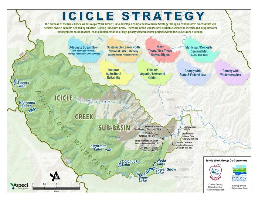
Department of Ecology’s Regional Offices
                          Map of Counties Served

    Region                Counties Served                   Mailing Address        Phone
               Clallam, Clark, Cowlitz, Grays Harbor,
                                                           PO Box 47775
Southwest      Jefferson, Mason, Lewis, Pacific, Pierce,                        360-407-6300
                                                           Olympia, WA 98504
               Skamania, Thurston, Wahkiakum
               Island, King, Kitsap, San Juan, Skagit,     3190 160th Ave SE
Northwest                                                                       425-649-7000
               Snohomish, Whatcom                          Bellevue, WA 98008
                                                           1250 W Alder St
               Benton, Chelan, Douglas, Kittitas,
Central                                                    Union Gap, WA        509-575-2490
               Klickitat, Okanogan, Yakima
                                                           98903
               Adams, Asotin, Columbia, Ferry,
               Franklin, Garfield, Grant, Lincoln, Pend    4601 N Monroe
Eastern                                                                         509-329-3400
               Oreille, Spokane, Stevens, Walla Walla,     Spokane, WA 99205
               Whitman
                                                           PO Box 46700
Headquarters   Across Washington                                                360-407-6000
                                                           Olympia, WA 98504
2020 Columbia River Basin
Water Supply Inventory Report

          Office of Columbia River
   Washington State Department of Ecology
           Central Regional Office
              Union Gap, WA

    January 2021 | Publication 20-12-001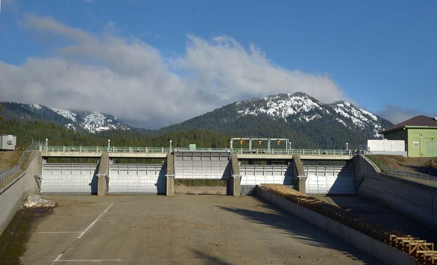
Table of Contents
List of Figures and Tables ............................................................................................................ iii
   Figures ............................................................................................................................................... iii
   Tables ................................................................................................................................................ iii

RCW 90.90.040 ........................................................................................................................... iv
   Columbia river water supply inventory—Long-term water supply and demand forecast. .............. v

RCW 90.90.020 ........................................................................................................................... vi
   Allocation and development of water supplies. ............................................................................... vi

Introduction ................................................................................................................................1
   The Office of Columbia River ............................................................................................................. 1
   COVID-19 Impacts .............................................................................................................................. 1
   2020 Accomplishments...................................................................................................................... 2
   Preparing for future water needs and improving drought resiliency................................................ 2
   Ecology’s strategic plan 2021-2023 ................................................................................................... 3

Odessa Groundwater Replacement Program ................................................................................6
   Ready to deliver water....................................................................................................................... 6
   Relieving Odessa aquifer demands .................................................................................................... 7
   Objectives .......................................................................................................................................... 9
   Water at a glance ............................................................................................................................... 9
   2020 milestones ................................................................................................................................. 9
   Anticipated 2021 milestones ............................................................................................................. 9

Integrated Water Resource Solutions ......................................................................................... 10
   Walla Walla Water 2050 .................................................................................................................. 10
   Icicle Creek Water Resource Management Strategy ....................................................................... 12
   Yakima River Basin Integrated Water Resource Management Plan ............................................... 17

Water Development Projects ..................................................................................................... 19
   Aquifer storage and recovery projects ............................................................................................ 19
   Proposed Switzler Reservoir Storage Project .................................................................................. 21
   Pasco Basin ...................................................................................................................................... 21

Developed Water....................................................................................................................... 22

Publication 20-12-001                                                                       2020 CRB Water Supply Inventory Report
Page i                                                                                                                January 2021
Water right permitting process ....................................................................................................... 22
   Lake Roosevelt Incremental Storage Release Program ................................................................... 23
   Sullivan Lake Water Supply Project ................................................................................................. 24
   Port of Walla Walla Lease Program ................................................................................................. 25
   McNary Pool .................................................................................................................................... 26

Trust Water and Instream Flows ................................................................................................ 26

Improving Statewide Drought Resiliency .................................................................................... 27

Budget Sustainability ................................................................................................................. 27

Public Outreach and Partnerships .............................................................................................. 29

Columbia River Treaty................................................................................................................ 29

Science Driven Decisions ............................................................................................................ 30

Anticipated 2021 Milestones...................................................................................................... 31

Conclusion ................................................................................................................................. 32

Publication 20-12-001                                                                  2020 CRB Water Supply Inventory Report
Page ii                                                                                                          January 2021
List of Figures and Tables

Figures
Figure 1 Icon Legend .............................................................................................................................. 1
Figure 2 Water Supply Development by the Office of Columbia River ................................................. 4
Figure 3 Map of OGWRP Proposed Pumping Plant and Delivery Systems, and Service Area. .............. 8
Figure 4 Map of the Walla Walla Basin ................................................................................................ 10
Figure 5 Map of the Icicle Creek Subbasin and the Eight Goals of the Strategy ................................. 16
Figure 6 Aquifer Storage and Recovery Schematic .............................................................................. 19
Figure 7 Location Map of the Proposed Switzler Reservoir................................................................. 21
Figure 8 OCR Permits Processed from 2006-2020 ............................................................................... 22

Tables
Table 1 Breakdown of Columbia River Basin Water Supply Development (CRBWSD) Funding Sources
.............................................................................................................................................................. 28

Publication 20-12-001                                                                         2020 CRB Water Supply Inventory Report
Page iii                                                                                                                January 2021
STATE OF WASHINGTON
                                      DEPARTMENT OF ECOLOGY
                       1250 W Alder St • Union Gap, Washington 98903-0009 • (509) 575-2490
               711 for Washington Relay Service • Persons with a speech disability can call 877-833-6341

January 25, 2021

The Honorable Jay Inslee, Governor
Honorable Members of the Washington State Legislature
Olympia, Washington

RE:    Columbia River Basin Water Supply Inventory Report

The Department of Ecology’s Office of Columbia River is pleased to present the 2020 Columbia River
Basin Water Supply Inventory Report to the Legislature, meeting the requirements under RCW
90.90.040. This report is now available at the following website:
https://apps.ecology.wa.gov/publications/SummaryPages/2012001.html

This annual Columbia River Basin Water Supply Inventory Report provides an updated summary of
water supply development project progress, project milestones met over the past year, and an
inventory list of water supplies developed since 2006.

As we continue to develop and deliver water both instream and out-of-stream across Eastern
Washington, we are excited to announce that after more than 16 years of dedicated work, the first
pumping plant and delivery system in the Odessa Groundwater Replacement Program finished
construction this year. The EL 47.5 system will deliver Columbia Basin Project surface water to 8,600
acres in the Odessa Subarea starting in March 2021.

If you have any questions regarding this report or would like more information, please contact me
by phone at (509) 952-5080 or by email at thomas.tebb@ecy.wa.gov. If you would like hard copies
of the report, contact Colleen Smith by phone at (509) 571-0921 or by email at
colleen.smith@ecy.wa.gov.

Sincerely,

G. Thomas Tebb, L.H.g., L.E.G.
Director
Office of Columbia River

Publication 20-12-001                                                 2020 CRB Water Supply Inventory Report
Page iv                                                                                         January 2021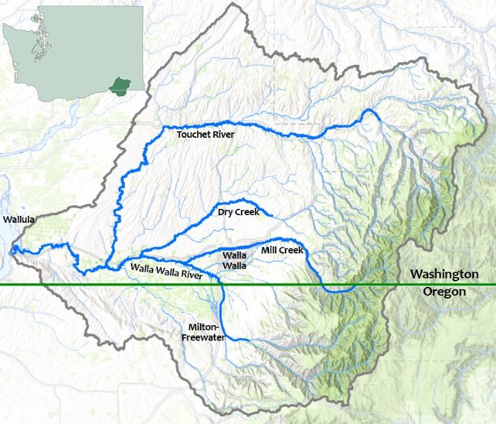
RCW 90.90.040
Columbia river water supply inventory—Long-term water
supply and demand forecast.
(1) To support the development of new water supplies in the Columbia river and to protect
instream flow, the department of ecology shall work with all interested parties, including interested
county legislative authorities and watershed planning groups in the Columbia River Basin, and
affected tribal governments, to develop a Columbia river water supply inventory and a long-term
water supply and demand forecast.
The inventory must include:
        (a) A list of conservation projects that have been implemented under this chapter and the
        amount of water conservation they have achieved; and
        (b) A list of potential water supply and storage projects in the Columbia River Basin,
        including estimates of:
                (i) Cost per acre-foot;
                (ii) Benefit to fish and other instream needs;
                (iii) Benefit to out-of-stream needs; and
                (iv) Environmental and cultural impacts.
(2) The department of ecology shall complete the first Columbia river water supply inventory by
November 15, 2006, and shall update the inventory annually thereafter.
(3) The department of ecology shall complete the first Columbia river long-term water supply and
demand forecast by November 15, 2006, and shall update the report every five years thereafter.
[2011 c 83 § 6; 2006 c 6 § 5.]

Publication 20-12-001                                        2020 CRB Water Supply Inventory Report
Page v                                                                                 January 2021
RCW 90.90.020
Allocation and development of water supplies.
(1) (a) Water supplies secured through the development of new storage facilities made possible
with funding from the Columbia River Basin water supply development account, the Columbia River
Basin taxable bond water supply development account, and the Columbia River Basin water supply
revenue recovery account shall be allocated as follows:
(i) Two-thirds of active storage shall be available for appropriation for out-of-stream
uses; and
(ii) One-third of active storage shall be available to augment instream flows and shall
be managed by the department of ecology. The timing of releases of this water shall
be determined by the department of ecology, in cooperation with the department
of fish and wildlife and fisheries co-managers, to maximize benefits to salmon and
steelhead populations.
(b) Water available for appropriation under (a)(i) of this subsection but not yet appropriated
shall be temporarily available to augment instream flows to the extent that it does not
impair existing water rights.
(2) Water developed under the provisions of this section to offset out-of-stream uses and for
instream flows is deemed adequate mitigation for the issuance of new water rights provided for in
subsection (1)(a) of this section and satisfies all consultation requirements under state law related
to the issuance of new water rights.
(3) The department of ecology shall focus its efforts to develop water supplies for the Columbia
River Basin on the following needs:
(a) Alternatives to groundwater for agricultural users in the Odessa Subarea aquifer;
(b) Sources of water supply for pending water right applications;
(c) A new uninterruptible supply of water for the holders of interruptible water rights on the
Columbia river mainstem that are subject to instream flows or other mitigation conditions
to protect streamflows; and
(d) New municipal, domestic, industrial, and irrigation water needs within the Columbia
River Basin.
(4) The one-third/two-thirds allocation of water resources between instream and out-of-stream
uses established in this section does not apply to applications for changes or transfers of existing
water rights in the Columbia River Basin.
[2011 c 83 § 4; 2006 c 6 § 3.
Publication 20-12-001 2020 CRB Water Supply Inventory Report
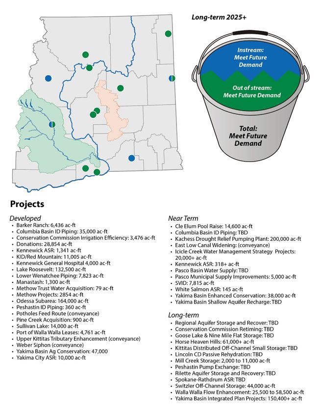
Page vi January 2021Introduction The Office of Columbia River The Department of Ecology (Ecology) formed the Office of Columbia River (OCR) to implement Chapter 90.90 of the Revised Code of Washington (RCW). The Washington State Legislature determined a Columbia River Basin water supply program was necessary in order to meet the current and future water needs of the basin for families, farms, and fish. In accordance with RCW 90.90.040, the Office of Columbia River submits this 2020 Columbia River Basin Annual Water Supply Inventory Report summarizing the accomplishments and ongoing efforts to meet the legislative mandate as defined in RCW 90.90. Over the past year, OCR has secured an additional 52,844 acre-feet (ac- ft.) through trust water donations, aquifer storage and recovery (ASR) projects, and water conservation efforts. This brings OCR's total amount of developed water supplies for instream and out-of-stream uses to 475,689 ac-ft. These water supplies hydrate pending water right applications, maintain adequate instream flows during the drier times of the year, reduce drought related impacts on interruptible water right holders, mitigation for the issuance of new water right permits, and will remove groundwater dependence in the Odessa Subarea. Throughout this report, each project and/or program will have one or more of the icons shown in Figure 1 associated with it. These icons represent OCR’s legislative mandate that each project or program meets. We anticipate that within the next five years the projects and programs currently in progress will develop an additional 285,878 ac-ft. of water. In total, OCR’s goal is to develop over 1 million ac-ft. over the next 10 years to meet water supply demands. With 475,689 ac-ft. permittable water supply coupled with the proposed 285,878 ac-ft., OCR is equipped to reach over 50 percent of our goal by 2025 based on the current path. Continued and consistent efforts to aggressively pursue Figure 1 Icon Legend the development of water supplies for farms, fish, and families set a sustainable path forward. The complete list of OCR water development projects is located on page 12 (Figure 2). COVID-19 Impacts The COVID-19 pandemic has temporally changed how OCR conducts business. In response to Governor Inslee’s “Stay Home, Stay Healthy” order, Ecology closed their offices statewide beginning mid-March. OCR’s work procedures have changed from in-person communication to virtual meetings, remote communication and document processing. While the full impacts of COVID-19 on Publication 20-12-001 2020 CRB Water Supply Inventory Report Page 1 January 2021
OCR projects are unknown at this time, work will continue to adapt and change to meet project
needs and safety and health requirements.

2020 Accomplishments
    •   Refined water supplies calculations, bringing OCR’s total amount of developed water supplies
        to 475,689 ac-ft.
    •   Achieved 91% on metering report compliance.
    •   Issued 15 water right permits.
    •   Completed construction of the last two siphons (Kansas Prairie 1 & 2) needed along East Low
        Canal for delivering surface water to the Odessa Subarea.
    •   Completed work on the East Low (EL) 47.5 pumping plant and delivery system that will
        deliver enough water to convert up to 10,500 acres of groundwater irrigated farmland to
        surface water irrigation in 2021, relieving an overstressed Odessa Subarea aquifer.
    •   Embarked on the Walla Walla Water 2050 strategic planning process in partnership with
        Ecology’s Water Resources Program, the state of Oregon, the Confederated Tribes of the
        Umatilla Indian Reservation and many local stakeholders.

Preparing for future water needs and improving drought
resiliency
In addition to securing water supplies for today’s instream flow needs and current out-of-stream
water users, OCR continues to make progress to secure enough water to meet future needs of
eastern Washington. OCR’s water supply development and delivery projects and programs provide
secure and reliable water benefitting instream flows for fish, and supports an over $8 billion
agricultural economy 2 and growing communities.
OCR publishes a long-term water supply and demand forecast report every five years, the next
report is due to the legislature in November 2021. We are working with several universities,
consulting professionals, and the State of Washington Water Research Center, to update the 2016
report and examine potential impacts to water supplies beyond 2040, including climate change,
population growth, and diminishing groundwater storage. This analysis provides water managers
with the information needed to assess current and future water demands and where to make
investments in water supply development projects that will optimize when and where water is
available to meet demands. This level of detail supports careful calculations of water supply and
demand, in the hopes of minimizing water use curtailments caused by climate change and amplified
low flow and drought conditions.

2
 Data acquired from Washington State Department of Agriculture 2019 export statistics, website link:
https://agr.wa.gov/departments/business-and-marketing-
support/international/statistics#:~:text=For%20more%20information%20call%20(360,agriculture%20exports%20tot
aled%20%247.1%20billion

Publication 20-12-001                                          2020 CRB Water Supply Inventory Report
Page 2                                                                                   January 2021
Ecology’s strategic plan 2021-2023
Ecology’s updated Strategic Plan3 summarizes how the agency is addressing ongoing environmental
challenges for the 2021-2023 biennium and beyond. Efforts and actions discussed in this plan build
on existing and past work.
Goals of Ecology’s Strategic Plan 2021-2023:
1. Support and engage our communities, customers, and employees
2. Reduce and prepare for climate impacts
3. Prevent and reduce toxic threats and pollution
4. Protect and manage our state's waters
5. Protect and restore Puget Sound
As a leader in developing water supplies and basin-wide integrated water resource management
solutions, OCR’s objectives directly support goals 2 and 4 of Ecology’s Strategic Plan. The Office of
Columbia River, along with other Ecology programs collaborate to achieve Ecology’s goals to deliver
integrated water solutions while protecting and managing Washington's vital water resources. The
involvement of communities, customers, and employees meets goal 1 through public notices,
requests for comments, and collaborative workgroup and committee participation.
Cle Elum Dam Pool Raise Radial Gates
Photo credit: Tim Poppleton, 2017
3
More information regarding Ecology’s Strategic Plan 2021-2023 can be found online at:
https://ecology.wa.gov/About-us/How-we-operate/Strategic-plan https://ecology.wa.gov/About-us/How-we-
operate/Strategic-plan
Publication 20-12-001 2020 CRB Water Supply Inventory Report
Page 3 January 2021Figure 2 Water Supply Development by the Office of Columbia River Publication 20-12-001 2020 CRB Water Supply Inventory Report Page 4 January 2021
Publication 20-12-001   2020 CRB Water Supply Inventory Report
Page 5                                            January 2021
Odessa Groundwater Replacement Program
Located in the heart of the Columbia River Basin, farmers in the arid Odessa Subarea have relied on
groundwater as a primary source of irrigation water for over 50 years. Regional irrigation demand
far exceeds the aquifer’s recharge capacity, causing groundwater levels to drop significantly. In the
areas of most extreme decline, well failure has occurred. This continual drop in aquifer levels forces
many farmers to drill deeper and deeper wells that, in turn, require more power to pump water to
the surface, increasing the overall cost of crop production. In addition to the costs associated with
declining groundwater levels, the water drawn from these depths is typically warmer and higher in
sodium content, which are not standards conducive to crop production.
Ready to deliver water
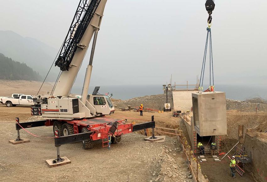
In 2020, the Odessa Groundwater
Replacement Program (OGWRP) hit several
milestones with completion of the last two
remaining siphons within the East Low Canal
(Kansas Prairie 1 & 2) and the East Low (EL)
47.5 pumping plant and delivery system.
OCR is excited to announce that after almost
two decades of hard work, major water
deliveries to the Odessa Subarea will
commence via the newly completed EL 47.5
system in the spring of 2021. The EL 47.5
system is the first delivery system of surface Pumps inside the EL 47.5 Pumping Plant
water to the Odessa Subarea and is designed
Photo credit: Melissa Downes (OCR), 2020
to deliver to up to 10,500 acres of irrigated farmland, however, only 8,600 acres have enrolled in
water service contracts with East Columbia Basin Irrigation District to replace Odessa groundwater
with Columbia Basin Project surface water. At this time, there are 1,900 acres of remaining available
capacity in the EL 47.5 system.
After nearly 20 years in the making and what started as the Odessa Subarea Special Study, is
today in full swing of implementation with major capital investments maximizing and expanding
the delivery capacity of existing federal Columbia Basin Project infrastructure. Impressively, the
state has invested over $105 million and the federal government has invested over $48 million,
to expand the East Low Canal and increase its delivery capacity and bring surface water stored
behind Grand Coulee Dam to the OGWRP lands. These monies have provided for feasibility,
engineering design, hydraulic modeling, cultural resource surveys, habitat evaluations, land
reclassifications, environmental impact statements, mitigation measures, water rights,
technical support, conservation efforts, rerouting water supplies and massive infrastructure
construction (additional siphon barrels, radial gates, canal widening, bridge modifications,
check structures). It is exciting to be on the cusp of delivering significant new water supplies to
OGWRP lands via the Columbia Basin Project & the EL 47.5 delivery system and to see the many
OGWRP pieces come together to provide some much needed relief to the aquifer, the natural
resource, and the local communities.
Publication 20-12-001 2020 CRB Water Supply Inventory Report
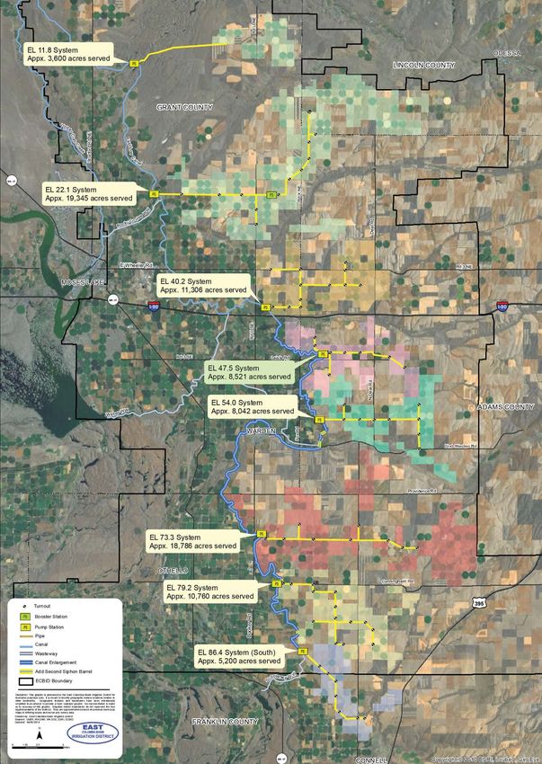
Page 6 January 2021Turnout and tractor at EL 47.5 Photo credit: Melissa Downes (OCR), 2020 Relieving Odessa aquifer demands Removing groundwater dependence in the Odessa Subarea is no easy feat. As one of OCR’s top legislative mandates in RCW 90.90.020, implementation of OGWRP commenced in 2006, building on previous efforts that were started in 2004. One of the first steps in removing the Odessa Subarea’s dependence on groundwater was identifying available surface water supplies. Reclamation, OCR, and the East Columbia Basin Irrigation District worked together to secure water from Banks Lake, Lake Roosevelt, and water conserved through the Columbia Basin Project’s irrigation districts Coordinated Conservation Program. With surface water in hand, work then focused on modifying existing infrastructure to convey this large amount of water to Odessa farmers, widening miles of the East Low Canal (ELC), installing additional siphon barrels, radial gates, upgrading the SCADA (Supervisory Control and Data Acquisition) electronic monitoring systems, and modifying county road bridges. Modifying and/or removing specific county road bridges are necessary along the canal to avoid the back up of water, which slows water delivery and risks flooding uplands adjacent to the bridges. At this time, two of the 10 bridges requiring modifications are complete. With ELC nearly finished, Ecology and OGWRP partners are now weighing options on pumping plant and delivery system designs. Next steps include installing a power grid substation serving East Low (EL) 22.1, and moving design work on both EL 22.1 and EL 79.2 towards 30 percent completion (Figure 3). Publication 20-12-001 2020 CRB Water Supply Inventory Report Page 7 January 2021
Figure 3 Map of OGWRP Proposed Pumping Plant and Delivery Systems, and Service Area
Source credit: East Columbia River Basin Irrigation District.

Publication 20-12-001                                           2020 CRB Water Supply Inventory Report
Page 8                                                                                    January 2021
Objectives
• Develop and deliver enough
surface water to convert
87,700 acres of irrigated
cropland from declining
groundwater sources to
surface water.
• Construct siphons, pumping
plants, and other
infrastructure required for the
delivery of the increased
amount of surface water to
the Odessa subarea.
• Modify county road bridges
crossing ELC once the canal
widening is complete.
• Provide an easy transition for
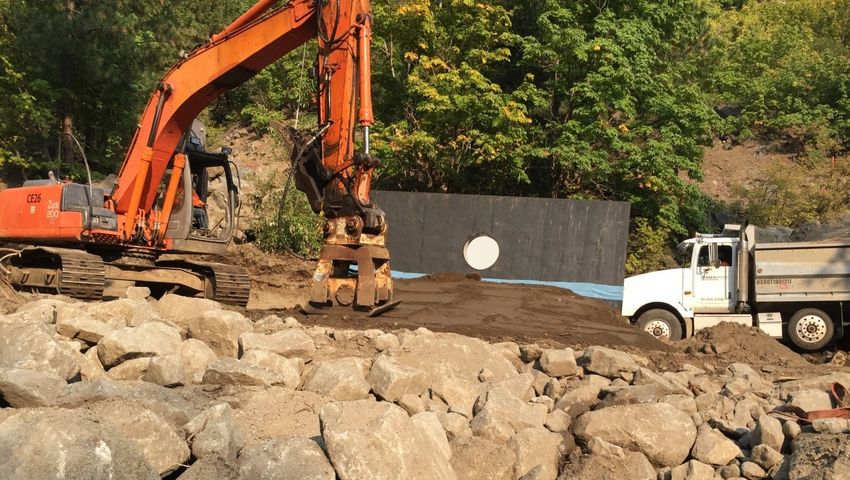
Kansas Prairie 2 siphon construction
landowners to change their Photo credit: Melissa Downes (OCR), 2020
existing water rights from
groundwater to surface water.
Water at a glance
• Surface water for the irrigation of 87,700 acres of cropland provided from:
o Banks Lake – 10,000 acres
o Lake Roosevelt – 70,000 acres
o Coordinated Conservation Program – 7,700 acres
2020 milestones
• Nine change applications issued.
• Master Water Service contract signed between Reclamation and East Columbia Basin
Irrigation District, and backed by a letter of support from the state’s Office of the Attorney
General.
• Construction complete on the final two final siphon barrels, Kansas Prairie 1 & 2.
• EL 47.5 pumping plant and water delivery system tests complete.
Anticipated 2021 milestones
• EL 47.5 to deliver enough water to irrigate up to 10,500 acres of farmland in March of 2021.
• Reach 30% to 60% design on the EL 22.1, and 79.2 pumping plant and delivery systems.
Publication 20-12-001 2020 CRB Water Supply Inventory Report
Page 9 January 2021Integrated Water Resource Solutions Walla Walla Water 2050 The 1.1 million acre Walla Walla Basin is a complex watershed extending across the Washington/Oregon state line (Figure 4). The basin struggles to meet existing out-of-stream water demands and maintain adequate instream flows vital for fish survival. Since 2009, the Walla Walla Watershed Management Partnership (Walla Walla Partnership) has worked with various stakeholders within the basin to develop and implement an innovative water management concept that enhances flexibility in water use as directed in RCW 90.92. These stakeholders include the Walla Walla Basin Watershed Council in Oregon, the Confederated Tribes of the Umatilla Indian Reservation, Ecology’s Water Resources Figure 4 Map of the Walla Walla Basin program, OCR, and regional water users. Authorized by the Washington Legislature in 2019, the Walla Walla Water 2050 (WWW2050) strategic plan initiative is a consensus-based effort by Ecology, state, federal, local, and tribal governments, and local agricultural and environmental stakeholders to develop a 30-year strategic water resource management plan for the entire Walla Walla Basin. Once complete, this plan will provide a framework to achieve holistic water resource management throughout the entire watershed in both states. These newly forming water management goals may be achieved by advancing a portfolio of potential projects and program solutions, providing sufficient and reliable water supplies to meet current and future instream and out-of-stream demands within the bi-state basin. In 2020, the state auditor’s office and an Ecology contractor conducted performance audit 4 and financial audit 5 evaluations, respectively, of the 10-year pilot program. The results from the audits are contained in a 2020 report to the legislature 6 published by the Walla Walla Partnership, which included recommendations for the WWW2050 strategic plan. The performance audit 4 Office of the Washington State Auditor, Performance Audit Assessing Success of the Walla Walla Watershed Management Partnership Pilot, May 12, 2020, Report Number 1025998. Website link: https://sao.wa.gov/performance_audit/assessing-success-of-the-walla-walla-watershed-management-partnership- pilot/ 5 Kraght Snell, Financial Evaluation Walla Walla Watershed Management Partnership, Walla Walla Watershed Management May 6, 2020. Website link: https://leg.wa.gov/jlarc/I- 900/Documents/6_3_20%20Public%20Testimony%20- %20Walla%20Walla%20Watershed%20Management%20Partnership.pdf 6 Walla Walla Watershed Management Partnership and Department of Ecology, Walla Walla Pilot Local Water Management Program Legislative Report to Implement 2SSB 5352, October 24. 2020.2020. Website link: https://drive.google.com/file/d/1HTiEf_wCDzsNNjCzhgHUDDEIVfR3hIi-/view Publication 20-12-001 2020 CRB Water Supply Inventory Report Page 10 January 2021
recommended returning “responsibility for water management in the Walla Walla Basin to the
Department of Ecology while maintaining the benefits of the Partnership in the form of an advisory
board that includes current membership.” The performance audit also recommended to Governor
Inslee to pursue an interstate compact with Oregon to address watershed management in the
Walla Walla watershed. The financial audit evaluation recommended that Ecology take the lead and
perform project management functions for continued work in the watershed. The 2020 Legislative
Report to Implement 2SSB 5352 provided the following recommendations:
  •   The strategic plan should encompass the entire watershed and involve all affected
      governments.
  •   Effects of watershed processes to the headwaters should be included in the strategic
      planning process.
  •   The strategic planning process should address the current challenges in managing water use
      across Washington and Oregon jointly.
  •   The organizational structure created to advise implementation of the strategic plan will need
      to include public and private entities and various local, state, and federal agencies and
      governments.
  •   For the upcoming biennium, funding is essential to complete the strategic plan, complete an
      Environmental Impact Statement of potential management options, support the U.S.
      Geological Survey groundwater study, and begin to fill critical data gaps.
The 2020 Legislative Report to Implement 2SSB 5352 also contained a recommendation for
RCW 90.92 to sunset as scheduled in June 2021.

Ongoing bi-State flow study
The 2017 and 2019 Walla Walla River Bi-State Flow Study reports found that a large-scale water
supply project is required to meet Walla Walla River instream flow targets for fish. Two large
projects have been evaluated to date, a Columbia River pump exchange, and a new surface storage
reservoir in tributary headwaters. At this time, Ecology is evaluating the feasibility of these two
projects, but more information is needed to inform significant remaining data gaps. Under the
current OCR agreement, the flow study steering committee continues to guide a consultant to help
fill in these data gaps while simultaneously engaging in the WWW2050 planning process.

Walla Walla Basin next steps
Commence:
  •   Development of the Programmatic Environmental Impact Statement for the WWW 2050
      strategic plan.
  •   Develop performance metrics for the WWW2050 strategies
Continue:
  •   US Geological Survey cooperative groundwater study
  •   Walla Walla River Bi-State flow study
  •   WWW2050 Strategic Plan Advisory Committee and Sub-Group meetings
  •   Guiding strategic plan development and implementation
  •   Secure funding sources for WWW2050 strategies

Publication 20-12-001                                     2020 CRB Water Supply Inventory Report
Page 11                                                                             January 2021
• Coordination amongst the Three-Sovereign Group 7 to evaluate options for multi-state water
resource management in the Walla Walla Basin
• Fill critical data gaps
Complete:
• WWW2050 strategic plan
Determine:
• Framework for local stakeholder participation and/or organizational structure
• Legislative changes or interstate compact needs to manage water resources in a bi-state
basin by the Three-Sovereign Group
Icicle Creek Water Resource
Management Strategy
Spanning across a portion of Chelan County from Josephine Lake to the City of Leavenworth, the
212 square mile Icicle Creek subbasin provides clean, cool water vital to the areas' fisheries,
instream flows, and out-of-stream water users (Figure 5). Current water management practices are
not keeping up with all of the needs in the subbasin.
The Icicle Creek Workgroup embarked on a plan in 2012 to meet the various water supply needs of
the subbasin by developing a framework for increasing instream flows and habitat function while
also addressing drought resiliency and climate change. As we flipped the calendar from 2019 to
2020, the workgroup moved from plan development into implementation.
To ensure future water supplies meet both instream flow and out-of-stream demands, Icicle Creek
Water Resource Management Strategy (Icicle Strategy) co-leads, Ecology and Chelan County,
continue moving forward on implementing a wide range of projects and actions identified under
the Icicle Strategy’s Final Programmatic EIS preferred alternative, Alternative 1. The Icicle Creek
Workgroup is considering the actions identified in the preferred alternative through a set of guiding
principles.
These principles include improving instream flows, sustainability of the Leavenworth National Fish
Hatchery, domestic and agricultural water supply reliability, while enhancing Icicle Creek habitat,
protecting tribal and non-tribal fish harvest, and complying with all federal, state, and local laws. In
total, the Icicle Strategy goals will provide 31,958 ac-ft. of reliable water supplies to meet out-of-
stream demands and to meet short-term (100 cfs) and long-term (250 cfs) instream flow goals.
Icicle Strategy Water Management Solutions
• Alpine Lakes Reservoirs Optimization, Modernization, and Automation
• Icicle-Peshastin Irrigation District Irrigation Efficiencies
• Cascade Orchards Irrigation Company Irrigation Efficiencies and Pump Exchange
• Domestic Conservation Efficiencies
7
The Three-sovereign Group consists of the states of Oregon and Washington, and the Confederated Tribes of the
Umatilla Indian Reservation.
Publication 20-12-001 2020 CRB Water Supply Inventory Report
Page 12 January 2021• Eightmile Lake Dam Reconstruction and Restoration
• Protect Tribal and Non-Tribal Fisheries
• Habitat Protection and Enhancement
• Instream Flow Rule Amendment
• Leavenworth National Fish Hatchery Conservation and Water Quality Improvements
• Fish Passage within Icicle Creek
• Fish Screening
• Water Marketing
Work currently underway
Fish Screen Replacement
The Icicle Peshastin Irrigation District (IPID) plans to modify the Snow Lake Trail Bridge so that it will
be able to handle the size and weight of the equipment needed to replace and maintain a new fish
screen located on the south side of Icicle Creek. Once complete, IPID will begin work on replacing
the existing fish screens. The Leavenworth National Fish Hatchery (LNFH) is kicking off the
environmental review process (NEPA 8) required for the surface water intake and fish screen
replacement projects. Finally, the City of Leavenworth fish screen replacement near the Boulder
Field is currently underway and expected to be complete by the end of 2020.
City of Leavenworth Fish screen replacement work near Boulder Field
Photo credit: Lisa Pelly (Trout Unlimited), 2020.
8
NEPA – National Environmental Policy Act
Publication 20-12-001 2020 CRB Water Supply Inventory Report
Page 13 January 2021Snow Lake
A part of the Icicle Strategy is the optimization,
modernization, and automation of outlets and
gates at seven Alpine Lakes 9 (Square,
Klonaqua, Eightmile, Colchuck, Nada, Upper
Snow, and Lower Snow lakes) within the
subbasin. Completed in 2019, Snow Lake valve
replacement provides improved control of
water releases to improve reliability for
agriculture and stream flow for
fish. Modernizing this aging infrastructure will
allow for more precise water releases from
these lakes, and provide optimal water storage
management resulting in benefits to instream
flow, fish, and agriculture needs during low
flow periods on Icicle Creek.
Fish Passage
The Boulder Field, aptly named for the large
rocks and boulders littering Icicle Creek near
river mile 5.6, is a barrier for fish migration.
Improving fish passage in this section of Icicle
Creek will open over 20 miles of upstream fish
habitat along the upper Icicle Creek and its
tributaries. Currently, contractors are in the
process of removing obstructions at the
Boulder Field and constructing a step-pool
fishway to allow for fish passage. The Boulder
Field fish passage project is set for completion
by the end of 2020.
Eightmile Lake Dam
Built during the 1920s, the Eightmile Lake Dam Fish passage at Boulder Field
Photo credit: Lisa Pelly (Trout Unlimited), 2020.
consists of rock, mortar, and dirt. A century of
wear and tear from wildfires, storms, freezing
waters, and flooding has degraded the dam to the point of compromised integrity. In 2017, the Jack
Creek Fire burned over 4,600 acres of forestland abutting the dam. This fire damage altered the
Eightmile Lake hydrology, resulting in faster and higher amounts of seasonal runoff putting
additional pressure on the already compromised dam. In early 2018, IPID implemented emergency
measures at Eightmile Lake Dam in response to the increased risk associated with additional run-off
that could lead to a dam failure. This temporary fix requires a more permanent solution to assure
the dam’s safety well into the 21st Century.
9
The Alpine Lakes are managed by multiple agencies including U.S. Fish and Wildlife Services, U.S. Bureau of
Reclamation, and the Icicle Peshastin Irrigation District.
Publication 20-12-001 2020 CRB Water Supply Inventory Report
Page 14 January 2021On December 18, 2020, Ecology kicked off the project level environmental review process for the
reconstruction and restoration of Eightmile Dam. Bringing the compromised and high hazard dam
into compliance with current state dam safety standards not only provides security to downstream
residents, it also allows for more precise future water releases. In turn, this project improves
instream flows for fish and increases the security and reliability of water supplies for out-of-stream
water users.
Anticipated work in 2021
Commence:
• Eightmile Dam reconstruction and restoration environmental review
• Snow Creek Trail bridge construction
Continue:
• IPID water conservation measures
• Alpine Lakes automation design
• Leavenworth National Fish Hatchery circular tank construction
Complete:
• Boulder Field Fish Passage
• IPID and Leavenworth Fish Screen replacements
• City of Leavenworth meter installation
• Leavenworth National Fish Hatchery Surface Water Intake Fish Screens and Fish Passage
(SWISP) Project environmental review
Icicle Strategy Workgroup Members:
• Department of Ecology
• Chelan County
• Cities of Leavenworth and Cashmere
• Icicle-Peshastin Irrigation District and Cascade Orchard Irrigation Company
• Icicle Creek Watershed Council
• Yakama Nation
• Confederated Tribes of the Colville Reservation
• Cascadia Conservation District
• Washington Department of Fish & Wildlife
• Washington Water Trust
• Trout Unlimited
• NOAA Fisheries
• US Bureau of Reclamation
• US Fish & Wildlife Service
• US Forest Service
• Individual Agriculture Representatives
Publication 20-12-001 2020 CRB Water Supply Inventory Report
Page 15 January 2021Figure 5 Map of the Icicle Creek Subbasin and the Eight Goals of the Strategy
Publication 20-12-001 2020 CRB Water Supply Inventory Report
Page 16 January 2021Yakima River Basin Integrated Water
Resource Management Plan
The Yakima River Basin Integrated Water Resource Management Plan (Integrated Plan) is the third
phase of the federal Yakima River Basin Water Enhancement Project (YRBWEP). Building on work
completed in the previous two YRBWEP phases, the Integrated Plan focuses habitat restoration and
conservation, fish passage, enhancing on-farm water conservation efforts, providing additional
water storage opportunities, tapping into existing water storage that are currently inaccessible, and
improving water market driven reallocations across the Yakima River Basin. Laid out as a 35-year
plan, the Integrated Plan consists of three separate phases: the Initial Development Phase, Middle
Development Phase, and Final Development Phase. The Integrated Plan is currently in its Initial
Development Phase, which focuses on projects that fall within all seven Integrated Plan elements.
Seven elements of the Integrated Plan
• Habitat/Watershed Protection and Enhancement
• Fish Passage
• Enhanced Water Conservation
• Structural and Operational Changes
• Surface Water Storage
• Groundwater Storage
• Market Driven Reallocation
Milestones achieved in 2020
• Achieving 55 percent of the 85,000 ac-ft. water conservation requirement set by the federal
2019 lands package (S.47 10).
• Significant continued progress on Cle Elum Fish Passage Facility construction.
• Construction of shoreline protection commenced at Wish Poosh Campground.
• Release of 230 Bull Trout in Gold Creek and Kachess River, near their natal streams.
• Continuation of groundwater studies taking place throughout the Yakima River Basin.
• Decision, made by the Roza Irrigation District Board of Directors, to move forward the
Kachess Drought Relief Pumping Plant floating pumping plant design.
• Completion of the Yakima Basin Managed Aquifer Recharge Assessment Final Report
identifying potential MAR sites throughout the Yakima River Basin.
• Launch of the Integrated Plan website 11.
10
S.47 - John D. Dingell, Jr. Conservation, Management, and Recreation Act, 116th Congress (2019-2020)
11
Integrated Plan website: https://yakimabasinintegratedplan.org/
Publication 20-12-001 2020 CRB Water Supply Inventory Report
Page 17 January 2021Anticipated Work for 2021
• Release of the 2020 Summer Sockeye study report evaluating potential fish passage issues
from the mouth of the Yakima River to Roza Dam.
• Provide support to Kittitas County on holding a 2021 Low Water Use and Heritage Garden
Workshop that encourages local municipalities and residents to utilize low water use
landscaping practices.
• Advance the Kachess Drought Relief Pumping Plan Tier 2 EIS towards completion.
Continue:
• Construction of Cle Elum Fish Passage remaining intakes and gates, secant drainage system
installation, and tunnel work.
• Agricultural and municipal enhanced water conservation efforts.
• Shoreline stabilization efforts along the Cle Elum reservoir.
• Floodplain restoration work across the Yakima River Basin.
• Support for Market Driven Reallocation.
• Study groundwater recharge across the Yakima River Basin.
• Clear Lake Dam fish passage design.
• Shoreline stabilization work at two embankment areas along Salmon La Sac Road.
Installation of a juvenile fish intake ramp at Cle Elum Reservoir Fish Passage
Photo credit: Richard Visser (Reclamation), 2020
Publication 20-12-001 2020 CRB Water Supply Inventory Report
Page 18 January 2021Water Development Projects Aquifer storage and recovery projects Aquifer Storage and Recovery (ASR) is a cost-effective water storage option currently pursued by an increasing number of municipalities across eastern Washington. ASR generally operates by capturing surplus surface water during times of high flows and injecting it into a local aquifer. The aquifer is a natural vessel that holds water with minimal additional infrastructure compared to a new surface water storage project. During times of low flows and droughts, this stored water is pumped back into a municipal system, providing water for out-of-stream end- Figure 6 Aquifer Storage and Recovery Schematic user distribution, and relieving demands on surface water. Many smaller municipalities in central Washington are looking into ASR as a secondary source of drinking water. In these areas, the shift of surface water dependence to artificially stored groundwater will take pressure off instream flows during times of low flows. Objective Explore and evaluate potential locations throughout the Columbia River Basin where local geologic conditions support ASR operations, provide permitting guidance and technical & financial assistance to develop suitable ASR systems. Current ASR projects City of Kennewick The City of Kennewick (Kennewick) has taken advantage of its surface water and shallow groundwater rights as sources for its ASR project. The city is currently capturing surface water from the Columbia River and injecting it into the Wanapum Basalt aquifer. As with all similar ASR projects, water is only diverted into the aquifer during periods of higher flows on the Columbia River (October-May) and pumped back out to the end-user during lower flows (May - October) when demands are at their highest. Publication 20-12-001 2020 CRB Water Supply Inventory Report Page 19 January 2021
Now that Kennewick’s ASR project is permitted and pilot testing is complete, the city is authorized
to capture up to 1,458 ac-ft. (October-May) and recover up to 1,341 ac-ft. (May-October) 12. At this
time, the city is working on the annual monitoring and reporting requirements as specified in its
permit provisions.
Othello
The City of Othello completed its pilot testing of Well 3R as a municipal water source. With positive
preliminary results, the city looks to move its ASR testing location to Well 8 which is closer to source
water (Columbia Basin Project canal water). The second phase of this study, which is currently
under development and review, includes well testing at a new location and water quality testing of
Reclamation’s canal water.
Quincy
The City of Quincy completed its aquifer characterization analysis and submitted the final report to
OCR in March 2020. Results of this characterization analysis found that this site has high potential
for use as an ASR project location. Quincy’s ASR project is one part of a larger study focused on how
the city can remove industrial wastewater discharge from the irrigation canal managed by
Reclamation. The city will begin its ASR cycle tests in the future.
West Richland
The City of West Richland is working on the first phases of an ASR feasibility study for use of City
well number 10 for storage and recovery. They have completed a well assessment and
rehabilitation of well 10 and will be performing an aquifer test in 2021. Next steps for this project
are described in Phase 2 of the 2019 Implementation Plan 13. The city will begin initial ASR pilot
testing once the preliminary permitting process is complete.
Pasco
Currently in its feasibility phase, the City of Pasco’s proposed ASR project could qualify to meet
water supply demands during the dryer months. If the process of characterizing the local
hydrogeology and analyzing Pasco’s permitting legal framework shows viable results, the city will
move to the next project phase of identifying ASR well sites and source water.
Natural Resources Damage Assessment
OCR is supporting the State’s Natural Resource Damage Assessment Team as they work towards
determining how the State should address Groundwater service losses at the Hanford site. This
support includes providing background information and context on OCR’s water supply efforts, and
demand and cost for water storage and water supply projects in the basin with an emphasis on the
Hanford area and downstream. By providing information on water demands and the costs of water
supply projects in the basin, OCR anticipates that this work will support funding for future water
supply and storage projects included as potential restoration projects.

12
   The amount of water recoverable from an ASR project are evaluated on a site specific case-by-case basis. This is
due to potential operation loss or loss due to gradient/groundwater flow, ASR projects are usually not allowed to
recover 100% of captured water.
13
   The full report can be found online at: https://apps.ecology.wa.gov/publications/SummaryPages/1912005.html

Publication 20-12-001                                               2020 CRB Water Supply Inventory Report
Page 20                                                                                       January 2021
Proposed Switzler Reservoir
Storage Project
Located in Switzler Canyon (Figure 7) in Benton
County, the proposed Switzler Reservoir Storage
project (Switzler) will require the construction of a
325 ft. high embankment dam, pipeline, and
pumping station to divert water from the Columbia
River during times of high flows. The reservoir will
inundate approximately 415 acres of uplands,
creating a surface storage reservoir capable of
holding up to 44,000 ac-ft. of water. Additionally,
this project will provide new economic opportunities
by providing water for new out-of-stream municipal
and agricultural uses. At this time, project co-leads   Figure 7 Location Map of the Proposed
Ecology, and Benton and Klickitat counties, continue Switzler Reservoir
working on the scoping process for the proposed
Switzler Reservoir Storage Project (Switzler) Environmental Impact Statement (EIS). Once scoping is
complete, project co-leads will complete the data gap analysis associated the EIS process and begin
to evaluate alternatives and potential impacts associated with this project.

Water allocation
     •   Instream flow augmentation on the Columbia River Mainstem below McNary dam through
         targeted reservoir releases.
     •   Mitigation for irrigation of 12,000 to 28,000 acres of new farmland.
     •   Mitigation for supplying water for up to 1,000 new homes.
     •   Mitigate potential impacts of interruptible water right curtailments on the Columbia River
         Mainstem.

Pasco Basin
With the development of the Columbia Basin Irrigation Project by the U.S. Bureau of Reclamation
(Reclamation), the groundwater characteristics within the project boundaries have undergone
significant change, including commingling of natural and “artificially stored” groundwater.
Currently, the aquifers underlying the Pasco Basin 14 are storing large quantities of water as a result
of long-term irrigation from the Columbia Basin Project. In 2016, The U.S. Geological Survey
quantified the amount and location of commingled groundwater in the Pasco Basin area. One
complication in allocating Pasco Basin groundwater is the presence of both naturally occurring
(state) and artificially stored (federal) groundwater. Therefore, Ecology and Reclamation have
agreed to pursue a framework on how to co-manage this water supply. Reclamation and Ecology
(both OCR and Water Resources) are working together to identify quantities of commingled
groundwater that may be suitable for future beneficial uses.

14
     WAC 508-14-030

Publication 20-12-001                                        2020 CRB Water Supply Inventory Report
Page 21                                                                                January 2021
Developed Water
Water right permitting process
Each year, the OCR water right permitting team receives, evaluates, and processes numerous
applications for new permanent and temporary water rights, and change of use and transfer
applications for existing water rights. OCR permit writers provide clear communication throughout
the entire permitting process including pre-application consultation and guidance through the
water right permitting application process. In effort to collect detailed and relevant project
information, the Water Resources program (WR) and OCR developed a new water right permit
application form and guidance document 15. This effort improves the service to customers and water
users by gathering additional information at the initial permit application step.
Since 2006, OCR has processed 210 applications (Figure 8), which calculates out to an average of 15
new and/or change applications and issues 10 permits annually. Issuing new permits on tributaries
to the Columbia River can have greater impacts to senior water right holders, instream flows, and
fish. The majority of the permits issued from OCR are on the Columbia River mainstem or its
tributaries.
Water demands continue to grow in eastern Washington, as does the need to develop more supply
for current and future demands. More information on projected water supply demands for the next
20 years is available in OCR’s Long-term Water Supply and Demands Forecast 16 that details water
demands.
Permits Processed 2006 - 2020
40
Applications Rejected
35 or Withdrawn
30 Change & Transfers
25
20 Tributary Permits
Issued
15
10
5
0
2006 2007 2008 2009 2010 2011 2012 2013 2014 2015 2016 2017 2018 2019 2020
Figure 8 OCR Permits Processed from 2006-2020
15
Form and guidance document can be found on Ecology’s website at https://ecology.wa.gov/Regulations-
Permits/Permits-certifications/Water-right-permits
16
OCR’s 2011 and 2016 Long-term Water Supply and Demand Forecast Reports can be found on Ecology’s website
at https://ecology.wa.gov/About-us/Get-to-know-us/Our-Programs/Office-of-Columbia-River/Office-of-Columbia-
River-Legislative-reports
Publication 20-12-001 2020 CRB Water Supply Inventory Report
Page 22 January 2021You can also read