PROPOSED NEW ACCESS ROADS & ADDITIONAL INFRASTRUCTURE, MARATABA SECTION OF MARAKELE NATIONAL PARK - South African Heritage Resource Agency
←
→
Page content transcription
If your browser does not render page correctly, please read the page content below
PROPOSED NEW ACCESS ROADS &
   ADDITIONAL INFRASTRUCTURE,
  MARATABA SECTION OF MARAKELE
          NATIONAL PARK
    Baseline Terrestrial Ecology Study &
          Sensitivity Assessment

                                APRIL 2018

Prepared for:   Peter Velcich
                NuLeaf Planning and Environmental
                PostNet Suite 168
                Private Bag X 844
                Silverton 0127

Prepared by:    Warren McCleland
                ECOREX Consulting Ecologists CC
                Postnet Suite 192
                Private Bag X2
                Raslouw 0109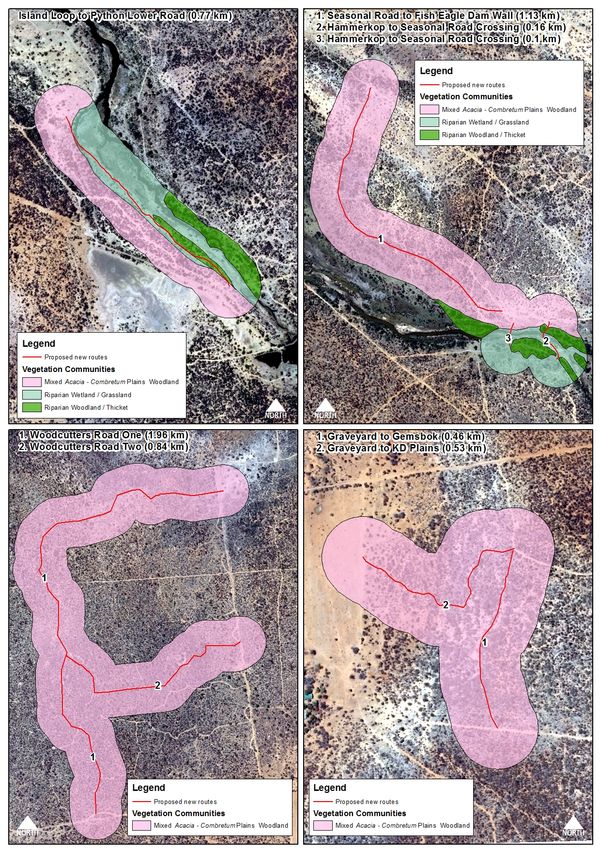
MARATABA ECOLOGY STUDY & SENSITIVITY ASSESSMENT (ECOREX)                                                                                                            APR 2018

                                                               TABLE OF CONTENTS

     LIST OF TABLES............................................................................................................................................ 3
     LIST OF FIGURES .......................................................................................................................................... 3
     ABBREVIATIONS ........................................................................................................................................... 5
     TERMINOLOGY .............................................................................................................................................. 5
     DECLARATION OF INDEPENDENCE ......................................................................................................... 6
     1.      INTRODUCTION ...................................................................................................................................... 7
     2.      TERMS OF REFERENCE ...................................................................................................................... 8
     3. STUDY AREA.............................................................................................................................................. 9
     4. METHODS ................................................................................................................................................. 11
          4.1 FLORA .................................................................................................................................................... 11
          4.2 FAUNA .................................................................................................................................................... 11
          4.3 BIODIVERSITY VALUE ASSESSMENT ....................................................................................................... 12
          4.4 ASSUMPTIONS, LIMITATIONS AND KNOWLEDGE GAPS ........................................................................... 13
            4.4.1 Seasonality .................................................................................................................................... 13
            4.4.2 Overlooked Species ..................................................................................................................... 13
     5. BIODIVERSITY BASELINE DESCRIPTION.......................................................................................... 14
          5.1 FLORA .................................................................................................................................................... 14
            5.1.1 Regional Context .......................................................................................................................... 14
            5.1.2 Local Vegetation Communities ................................................................................................... 15
            5.1.3 Conservation-Important Flora...................................................................................................... 21
          5.2 TERRESTRIAL FAUNA ............................................................................................................................. 26
            5.2.1 Mammals ....................................................................................................................................... 26
            5.2.2 Birds ............................................................................................................................................... 26
            5.2.3 Reptiles & Frogs ........................................................................................................................... 29
     6. SENSITIVITY ASSESSMENT ................................................................................................................. 30
     7. KEY POTENTIAL IMPACTS ................................................................................................................... 31
     8. CONCLUSION & RECOMMENDATIONS .............................................................................................. 32
     9. REFERENCES .......................................................................................................................................... 33
     10. APPENDICES ......................................................................................................................................... 34
          APPENDIX 1. CHECKLIST OF FLORA RECORDED DURING FIELDWORK ........................................................... 34
          APPENDIX 2. POTENTIALLY OCCURRING PLANT SPECIES OF CONSERVATION CONCERN ............................... 38
          APPENDIX 3. CO-ORDINATES OF PLANTS OF CONSERVATION-IMPORTANCE RECORDED DURING FIELDWORK
          ..................................................................................................................................................................... 40
          APPENDIX 4. CHECKLIST OF FAUNA RECORDED DURING FIELDWORK ........................................................... 47
          APPENDIX 5. POTENTIALLY OCCURRING FAUNA OF CONSERVATION CONCERN............................................. 53
          APPENDIX 6. BIODIVERSITY VALUES OF VEGETATION COMMUNITIES ........................................................... 55
          APPENDIX 7. CURRICULUM VITAE OF DUNCAN MCKENZIE ................................ ERROR! BOOKMARK NOT DEFINED.
          APPENDIX 8. SPECIALISTS DECLARATION .................................................................................................... 58

                          ECOREX Consulting Ecologists CC
                  2       Postnet Suite #192, Private Bag X2 Raslouw 0109
                          (083) 231-5632 warren@ecorex.co.za
MARATABA ECOLOGY STUDY & SENSITIVITY ASSESSMENT (ECOREX)                                                                                       APR 2018

     List of Tables
     Table 1. Sensitivity Driver Scores ................................................................................................................ 12
     Table 2. Overall Sensitivity and Importance Scores................................................................................... 12
     Table 3. Protected plant species confirmed during fieldwork .................................................................... 21
     Table 4. Most frequently encountered species in the Woodland Assemblage ........................................ 28
     Table 5. Sensitivity Assessment of Proposed Roads................................................................................. 30

     List of Figures
     Figure 1. Location of Study Area.................................................................................................................. 10
     Figure 2. Photographs of different forms of Acacia - Combretum Plains Woodland............................... 16
     Figure 3. Photographs of Broad-leaved Woodland (Dassie Road)........................................................... 18
     Figure 4. Photographs of Riparian Woodland / Thicket ............................................................................. 19
     Figure 5. Photographs of Riparian Grassland / Wetland ........................................................................... 20
     Figure 6. Vegetation communities within 200m buffer along proposed roads (1) ......................... 22
     Figure 7. Vegetation communities within 200m buffer along proposed roads (2) ......................... 23
     Figure 8. Vegetation communities within 200m buffer along proposed roads (3) ......................... 24
     Figure 9. Vegetation communities in the vicinity of the additional infrastructure units............... 25
     Figure 10. Species accumulation curve for November 2017 fieldwork .................................................... 27

                      ECOREX Consulting Ecologists CC
                3     Postnet Suite #192, Private Bag X2 Raslouw 0109
                      (083) 231-5632 warren@ecorex.co.za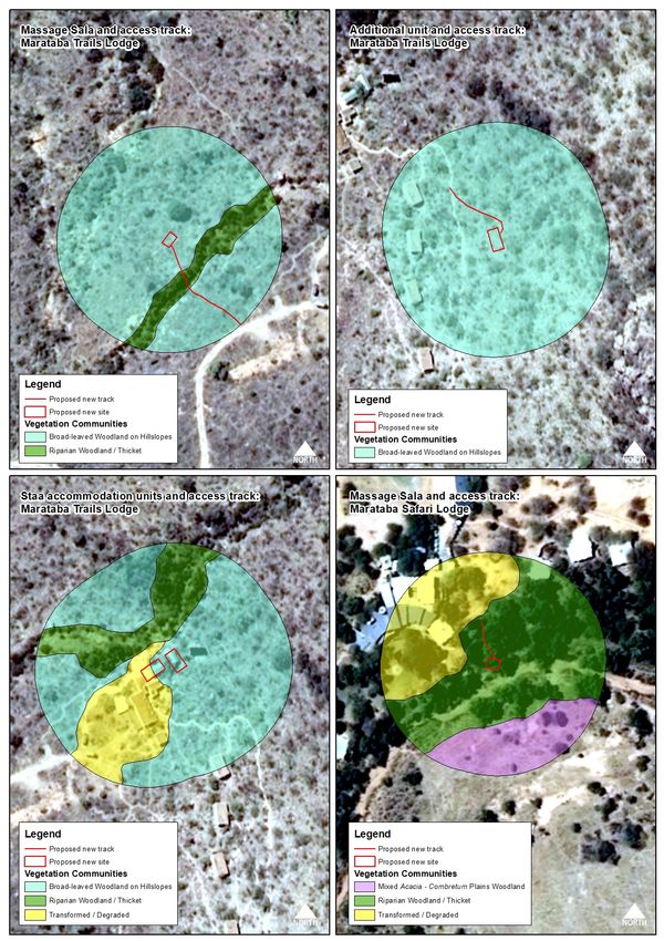
MARATABA ECOLOGY STUDY & SENSITIVITY ASSESSMENT (ECOREX) APR 2018
EIA REGULATIONS SPECIALISTS REPORT CHECKLIST
(1) A specialist report prepared in terms of the 2014 Environmental Impact Assessment Regulations must contain-
(a) details of-
(i) the specialist who prepared the report; and page 7
(ii) the expertise of that specialist to compile a specialist report including a curriculum vitae; page 53
(b) a declaration that the specialist is independent in a form as may be specified by the competent authority; page 56
(c) an indication of the scope of, and the purpose for which, the report was prepared; page 8
(d) the date and season of the site investigation and the relevance of the season to the outcome of the assessment; page 12
(e) a description of the methodology adopted in preparing the report or carrying out the specialised process; page 10
(f) the specific identified sensitivity of the site related to the activity and its associated structures and infrastructure; page 28
(g) an identification of any areas to be avoided, including buffers; page 28
(h) a map superimposing the activity including the associated structures and infrastructure on the environmental
page 21
sensitivities of the site including areas to be avoided, including buffers;
(i) a description of any assumptions made and any uncertainties or gaps in knowledge; page 12
(j) a description of the findings and potential implications of such findings on the impact of the proposed activity,
page 29
including identified alternatives on the environment;
(k) any mitigation measures for inclusion in the EMPr; page 30
X (l) any conditions for inclusion in the environmental authorisation; n/a
(m) any monitoring requirements for inclusion in the EMPr or environmental authorisation; n/a
(n) a reasoned opinion-
(i) as to whether the proposed activity or portions thereof should be authorised; and page 30
(ii) if the opinion is that the proposed activity or portions thereof should be authorised, any avoidance,
management and mitigation measures that should be included in the EMPr, and where applicable, the closure page 30
plan;
(o) a description of any consultation process that was undertaken during the course of preparing the specialist
X n/a
report;
(p) a summary and copies of any comments received during any consultation process and where applicable all
X n/a
responses thereto; and
(q) any other information requested by the competent authority. n/a
ECOREX Consulting Ecologists CC
4 Postnet Suite #192, Private Bag X2 Raslouw 0109
(083) 231-5632 warren@ecorex.co.za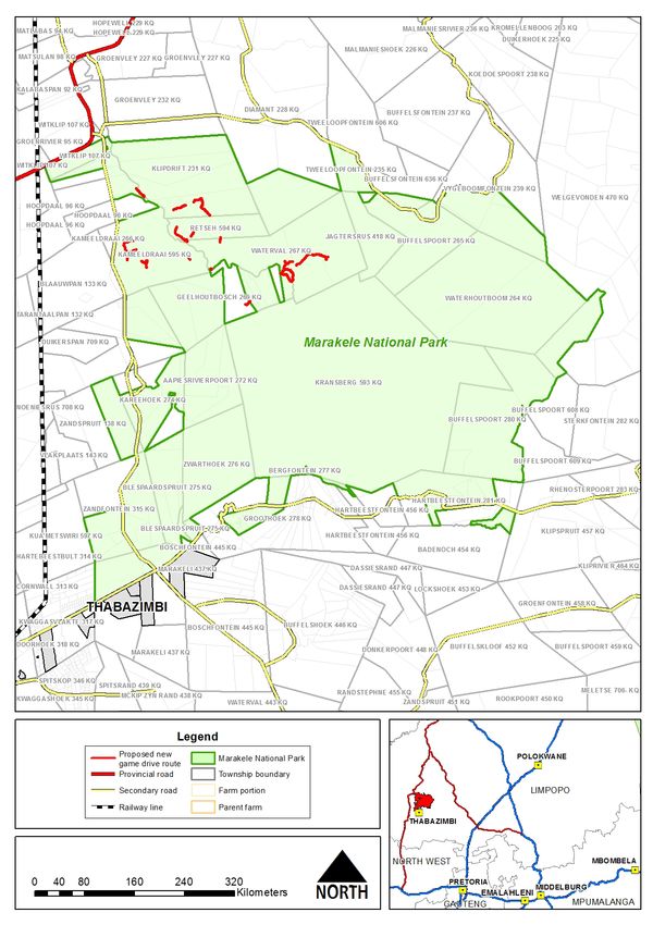
MARATABA ECOLOGY STUDY & SENSITIVITY ASSESSMENT (ECOREX)                                        APR 2018

     Abbreviations
     IBA                        Important Bird Area
     IUCN                       International Union for Conservation of Nature
     mamsl                      Metres Above Mean Sea Level
     NEMBA ToPS                 National Environmental Management: Biodiversity Act Threatened
                                or Protected Species (No. 10 of 2004)
     NFA                        National Forest Act (No. 30 of 1998)
     QDS                        Quarter Degree Square, for example 2431 AC

     Terminology

     Alien                      Introduced from elsewhere: neither endemic nor indigenous.
     Biodiversity               The structural, functional and compositional attributes of an area,
                                ranging from genes to landscapes.
     Epiphytic                  Living on the surface of other plants without causing harm
     Geophyte                   Plants that produce their growth points from organs stored below
                                the ground, an adaption to survive frost, drought and / or fire.
     Transformed                Transformed ecosystems are no longer natural and contain little or
                                no   indigenous    flora.   Examples   include   agricultural   lands,
                                plantations, urban areas, etc.

                 ECOREX Consulting Ecologists CC
             5   Postnet Suite #192, Private Bag X2 Raslouw 0109
                 (083) 231-5632 warren@ecorex.co.za
MARATABA ECOLOGY STUDY & SENSITIVITY ASSESSMENT (ECOREX)                                     APR 2018

     Declaration of Independence
     We declare that we have been appointed as independent consulting ecologists with no
     affiliation with or vested financial interests in the proponent, other than for work performed
     under the Environmental Impact Assessment Regulations, 2010. We have no conflicting
     interests in the undertaking of this activity and have no interests in secondary developments
     resulting from the authorisation of this project. Remuneration for our services by the proponent
     is not linked to approval by any decision-making authority responsible for authorising this
     development.

     W.L. McCleland                                       28 April 2018

                ECOREX Consulting Ecologists CC
            6   Postnet Suite #192, Private Bag X2 Raslouw 0109
                (083) 231-5632 warren@ecorex.co.za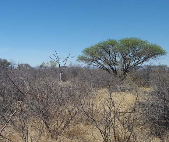
MARATABA ECOLOGY STUDY & SENSITIVITY ASSESSMENT (ECOREX)                                         APR 2018

     1. INTRODUCTION
     Marakele Park (Pty) Ltd intends to apply for Environmental Authorisation from the National
     Department of Environmental Affairs (DEA) for the proposed establishment of approximately
     20 km of additional game viewing tracks, as well as two Sala massage units and additional
     accommodation units within the Marataba Section of the Marakele National Park, Limpopo
     Province. ECOREX Consulting Ecologists CC was appointed by Peter Velcich of NuLeaf
     Planning and Environmental to perform an ecology survey of these proposed roads and
     additional infrastructure, which will form part of the EIA for this project. This study will provide
     a basis for assessing potential impacts of the proposed project on terrestrial ecology and guide
     the design and location of the infrastructure. The study comprised flora and key vertebrate
     fauna (mammals, birds, reptiles, frogs) and took place over three days in November 2017.

     The study team was as follows:

     Warren McCleland (Terrestrial Ecologist). Warren is the owner and director of ECOREX
     Consulting Ecologists CC, a consultancy of flora and vertebrate fauna specialists based in
     Mpumalanga, South Africa. He has been involved in specialist biodiversity assessments for a
     wide range of developments, particularly mining, throughout sub-Saharan Africa over the past
     14 years. Countries of work experience outside of South Africa include Democratic Republic
     of the Congo, Republic of Guinea, Sierra Leone, Liberia, Mali, Tanzania, Zambia, Malawi,
     Mozambique, Namibia and Swaziland. Warren is the co-author of the “Field Guide to the Trees
     & Shrubs of Mpumalanga & Kruger National Park” (2002), for which he was awarded the
     Marloth Medal from the Botanical Society of South Africa, and is currently working on a field
     guide to the Wildflowers of the Kruger National Park. A more detailed CV is presented in
     Appendix 6.

     Linda McKenzie (GIS Specialist). Linda is a GIS Specialist/GIS Analyst with over 12 years’
     experience in the industry. For the last four years she has operated her own GIS Consultancy
     called Digital Earth. She has extensive experience in both the private and public sector, as
     has worked on a wide variety of projects and GIS applications. These include, most recently,
     vegetation and sensitivity mapping, landcover data capture, municipal roads master planning,
     hydroelectric scheme and wind farm feasibility mapping and town planning, land surveyor and
     engineering support services. Linda currently serves as treasurer for GISSA Mpumalanga and
     is a registered Professional GISc Practitioner (PGP0170).

                ECOREX Consulting Ecologists CC
            7   Postnet Suite #192, Private Bag X2 Raslouw 0109
                (083) 231-5632 warren@ecorex.co.za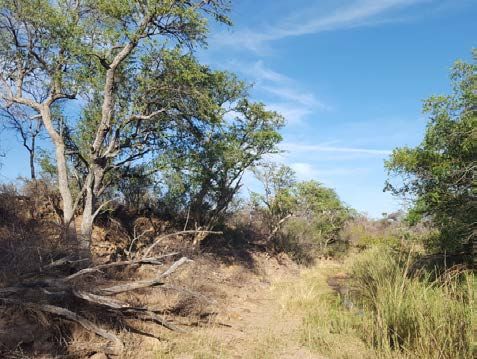
MARATABA ECOLOGY STUDY & SENSITIVITY ASSESSMENT (ECOREX)                                 APR 2018

     2.       TERMS OF REFERENCE

     A. Conduct an assessment of the terrestrial ecosystems within the project area (vertebrate
          fauna and flora), which will include the following:

          o   Brief description of vegetation communities;

          o   Overview of potentially occurring plant species of conservation concern;

          o   Vegetation Map;

          o   Description of bird assemblages;

          o   Overview of potentially occurring fauna species of conservation concern (mammals,
              birds, reptiles and frogs).

     B. Assessment of the Ecological Sensitivity of the habitats represented at each of the
          proposed roads and additional infrastructure.

     C. Deliverables:
          •   A report on Terrestrial Ecosystems, comprising:
                  o   Description of receiving environment (biodiversity baseline);
                  o   Vegetation Map;
                  o   Ecological Sensitivity assessment;
                  o   Recommendations regarding infrastructure layout, where relevant.

                  ECOREX Consulting Ecologists CC
              8   Postnet Suite #192, Private Bag X2 Raslouw 0109
                  (083) 231-5632 warren@ecorex.co.za
MARATABA ECOLOGY STUDY & SENSITIVITY ASSESSMENT (ECOREX)                                  APR 2018

     3. STUDY AREA
     The proposed development is located in the Marataba Section of the Marakele National Park,
     in the Lephalale Local Municipality, approximately 50 km north-east of Thabazimbi, Limpopo
     Province (Figure 1). The project comprises the establishment of approximately 20 km of
     additional game viewing tracks within the Marataba Section of the Marakele National Park.
     The following additional infrastructure were added to the project footprint in 2018, but were
     not surveyed in the field:
        •   One additional two-bed guest unit (120m2) with pedestrian footpath at the existing
            Marataba Trails Lodge;
        •   Two staff accommodation units (190m2) at the existing Marataba Trails Lodge to
            replace the existing staff tents;
        •   One Massage Sala (Spa) structure (35m2) and pedestrian footpath at the existing
            Marataba Trails Lodge;
        •   One Massage Sala (Spa) structure (35m2) at the existing Marataba Safari Lodge.

     The study area is situated within the quarter-degree grid 2427 BC between elevations of
     approximately 990 and 1138 mamsl.

                ECOREX Consulting Ecologists CC
            9   Postnet Suite #192, Private Bag X2 Raslouw 0109
                (083) 231-5632 warren@ecorex.co.za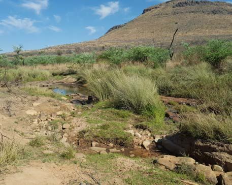
MARATABA ECOLOGY STUDY & SENSITIVITY ASSESSMENT (ECOREX)         APR 2018

     Figure 1. Location of Study Area

               ECOREX Consulting Ecologists CC
          10   Postnet Suite #192, Private Bag X2 Raslouw 0109
               (083) 231-5632 warren@ecorex.co.za
MARATABA ECOLOGY STUDY & SENSITIVITY ASSESSMENT (ECOREX) APR 2018
4. METHODS
4.1 Flora
Desktop
Broad-scale vegetation communities were identified prior to fieldwork using Google EarthTM
satellite imagery. Red Data plant species listed for the quarter-degree grid 2427 BC in the
Botanical Database of Southern Africa (BODATSA), which contains records from the National
Herbarium in Pretoria, the Compton Herbarium in Cape Town and the KwaZulu-Natal
Herbarium in Durban, were used to produce a list of the most likely species of conservation
concern, which were searched for during fieldwork.
Fieldwork
Transects were walked along most of the proposed new game drive tracks during fieldwork
(1-3 November 2017), while several tracks were driven in an open game-viewing vehicle.
Dominant and diagnostic plant species were noted for each transect but comprehensive plant
lists were not compiled because of the paucity of undergrowth species as a result of the very
dry period at the time of fieldwork. Focus was placed on locating plant species of conservation
concern along each transect.
4.2 Fauna
Desktop
Lists of potentially occurring conservation-important mammals, birds, reptiles and frogs
potentially were prepared using Swanepoel et al. (2016), the Southern African Bird Atlas
Project 2 http://sabap2.adu.org.za/, Taylor et al. (2016), Minter et al. (2004) and Bates et al.
(2014). The above data were captured mostly at a quarter-degree spatial resolution, but were
refined by excluding species unlikely to occur within the study area, due to unsuitable habitat
characteristics (e.g. altitude and land-use). Bat species thought to only forage over the study
area (i.e. mostly cave-roosting species) were not included in the assessment due to the lack
of suitable roosting sites within the study area. Potential occurrence of fauna in the study area
was predicted based on knowledge of known habitat requirements of each species.
ECOREX Consulting Ecologists CC
11 Postnet Suite #192, Private Bag X2 Raslouw 0109
(083) 231-5632 warren@ecorex.co.zaMARATABA ECOLOGY STUDY & SENSITIVITY ASSESSMENT (ECOREX) APR 2018
Fieldwork
Birds were identified visually using Swarovski 10x42 EL binoculars or by listening to calls of
species hidden in dense vegetation. Observations were made incidentally during the time that
the vegetation survey was conducted and limited to birds seen and heard within the study area
and immediate surrounds. Mammals, reptiles and frogs were recorded incidentally as they
were encountered during the survey through direct evidence (sightings) and indirect evidence
(spoor, dung).
4.3 Sensitivity and Importance Assessment
The overall ecological sensitivity of the proposed roads was assessed against seven
Sensitivity Drivers on a sensitivity matrix. A score between zero and five was given for each
of the Drivers with zero indicating an absent or not applicable impact and five that of a very
high or confirmed one (Table 1). These scores were summed and compared to the sensitivity
values reflected in Table 2. Scores of 21 or higher indicate options with a high sensitivity,
indicating potentially high biodiversity / development conflict. Most favourable sites are those
with lower potential for conflict.
Table 1. Sensitivity Driver Scores
SENSITIVITY DRIVER SCORE
1 = Very low / Negligible
2 = Low
3 = Moderate
4 = High
5 = Very High
Table 2. Overall Sensitivity and Importance Scores
OVERALL SENSITIVITY SCORE
7-10 = Very low / Negligible
11-15 = Low
16-20 = Moderate
21-25 = High
26-35 = Very High
ECOREX Consulting Ecologists CC
12 Postnet Suite #192, Private Bag X2 Raslouw 0109
(083) 231-5632 warren@ecorex.co.zaMARATABA ECOLOGY STUDY & SENSITIVITY ASSESSMENT (ECOREX) APR 2018
4.4 Assumptions, Limitations and Knowledge Gaps
4.4.1 Seasonality
The assessment was based on a single field survey in the early part of the wet season (1-3
November 2017). Rains had not yet arrived when fieldwork commenced and many species
that are usually flowering at that time of the year were not yet in flower. Plants which flower at
other times of the year were also underrepresented although this is not seen as a limitation
that could affect the Record of Decision as the habitat is only suitable for a limited number of
plant species of conservation concern. The likelihood of occurrence of these species is dealt
with in this report.
4.4.2 Overlooked Species
Certain plant species, particularly geophytes, will only flower in seasons when conditions are
optimal and may thus remain undetected, even over a survey that encompasses several
seasons. Other plant species may be overlooked because of very small size and / or extreme
rarity. A sampling strategy will always represent merely a subset of the true diversity of the
study area. However, the level of sampling effort for this study is considered appropriate for
the objectives of the study.
4.4.3 Additional Infrastructure
The additional accommodation units and massage Salas were added to the project footprint
in 2018 and were thus not surveyed during November 2017 fieldwork. However, it was decided
to assess these units at a desktop level for the following reasons:
• the impact footprint of each additional unit is very small, and the accommodation units
are to be built on stilts;
• several of the new units are in habitats within the vicinity of the trails lodge that are
already ecologically compromised;
• the vegetation communities within which the new units are located have been
assessed during the 2017 fieldwork and are described in this report, allowing for
sensitivity assessment to be undertaken for each new unit;
• photos of the proposed sites for each unit were sent to the specialist so that habitat
structure and condition could be confirmed.
This limitation should thus not impact on a record of decision being made.
ECOREX Consulting Ecologists CC
13 Postnet Suite #192, Private Bag X2 Raslouw 0109
(083) 231-5632 warren@ecorex.co.zaMARATABA ECOLOGY STUDY & SENSITIVITY ASSESSMENT (ECOREX) APR 2018
5. BIODIVERSITY BASELINE DESCRIPTION
5.1 Flora
5.1.1 Regional Context
National Vegetation Types
According to Mucina & Rutherford (2006), the study area is situated within the Western Sandy
Bushveld vegetation type, which is in the Central Bushveld Bioregion of the Savanna Biome.
The higher-lying, mountainous part of Marakele National Park is situated in Waterberg
Mountain Bushveld, which is not represented in the study area. Western Sandy Bushveld is
located on flats and undulating plains north, west and south-west of the Waterberg Mountains
between Steenbokpan in the north and Borakalalo National Park in the south. Vegetation
structure varies from tall open woodland to low closed woodland, with both broad-leaved and
microphyllous species dominant. Geology falls within the Mokolian Waterberg group and
comprises mostly sandstone and mudstone of the Matlabas Subgroup, as well as sandstone,
subordinate conglomerate, siltstone and shale of the Kransberg Subgroup. Soils are mostly
plinthic catena, eutrophic, red-yellow apedal, freely drained, with high base status, mostly
Hutton and Clovelly forms. Dominant trees include species such as Acacia erubescens, A.
mellifera subsp. detinens, A. nilotica, A. tortilis subsp. heteracantha, Combretum apiculatum,
C. imberbe and Terminalia sericea.
Western Sandy Bushveld was assessed by Mucina & Rutherford (2006) as Least Threatened
because of a low level of transformation (4%) and because 6% of the protection target of 19%
is conserved, primarily in the Marataba Section of Marakele National Park.
Centres of Plant Endemism
While the study area is not situated in any floristic centres of endemism, i.e. areas that have
an unusually high number of plants unique to that area, as described by Van Wyk & Smith
(2001), it is situated within the proposed Waterberg Centre of Endemism (Hahn, 2002)
although this has not yet been formally described.
Threatened Ecosystems
The study area is not listed as a Threatened Ecosystem (Notice 1002 of Government Gazette
34809, 9 December 2011).
ECOREX Consulting Ecologists CC
14 Postnet Suite #192, Private Bag X2 Raslouw 0109
(083) 231-5632 warren@ecorex.co.zaMARATABA ECOLOGY STUDY & SENSITIVITY ASSESSMENT (ECOREX) APR 2018
Limpopo Conservation Plan
The study area is situated within a protected area as listed under the National Environmental
Management: Protected Areas Act (No. 57 of 2003) (NEMPAA) and is categorised as a Formal
Protected Area within the Limpopo Conservation Plan (Desmet et al., 2013). The land-use
guidelines for such a protected area are:
• Maintain in a natural state with limited or no biodiversity loss.
• Rehabilitate degraded areas to a natural or near natural state and manage for no
further degradation.
• Development subject to Protected Area objectives and zoning in a NEMPAA compliant
and approved management plan.
5.1.2 Local Vegetation Communities
Four untransformed vegetation communities were identified within the proposed development
site on the basis of distinctive vegetation structure (grassland, woodland, thicket, etc.), floristic
composition (dominant and diagnostic species) and position in the landscape (mid-slopes,
terrace, crest, etc.). These vegetation communities are described briefly below, and species
lists are provided in Appendix 1.
5.1.2.1 Mixed Acacia - Combretum Plains Woodland
This is the dominant vegetation community within the study area and covers fifteen of the
proposed tracks (Figures 6-8). Various tree and shrub species are dominant in different areas
depending on soil type (Figure 2). These sub-communities are:
• Red sandy soils in western part of the study area – Acacia tortilis is clearly dominant,
while other prominent tree species include Acacia erioloba, A. mellifera and Boscia
albitrunca; four roads are covered by this sub-community, namely Woodcutter Road
options 1 and 2, Graveyard to KD Plains and Graveyard to Gemsbok;
• Brown clayey sands in central and eastern parts of the study area – a mix of Acacia
species with none clearly dominant, particularly A. erubescens, A. mellifera, A.
erioloba, A. luederitzii and A. tortilis, as well as Combretum hereroense; Grewia flava
and Dichrostachys cinerea are prominent understory species; this sub-community is
prominent on Hapoor Rhino Lookout Link, Coqui to Tshukadu South Link, Seasonal
Road to Fish Eagle Dam, Nakedi to Kgadi’s Pan, Tshukadu South Road Link, Blue
Gwarrie to Noka Road and parts of Blue Gwarrie to Kubu Dam road;
• Deep, pale sands, often on old flood terraces – Terminalia sericea is dominant; this
sub-community is most prominent on parts of the Blue Gwarrie to Kubu Dam road;
ECOREX Consulting Ecologists CC
15 Postnet Suite #192, Private Bag X2 Raslouw 0109
(083) 231-5632 warren@ecorex.co.zaMARATABA ECOLOGY STUDY & SENSITIVITY ASSESSMENT (ECOREX) APR 2018
• Sodic or duplex soils – Acacia erubescens is dominant, while other diagnostic species
include Euclea undulata and Spirostachys africana; this vegetation community is well
represented on Caracal to Makanyane road, while patches are present on Blue
Gwarrie to Noka Road, Coqui to Tshukadu South Link, Seasonal Road to Fish Eagle
Dam and Nakedi to Kgadi’s Pan;
• Rocky or gravelly soils, usually on higher lying crests or upper slopes – Combretum
apiculatum and C. hereroense are clearly dominant, with other common species being
Grewia flava, Peltophorum africanum and Dichrostachys cinerea; found in patches on
Blue Gwarrie to Kubu Dam and Blue Gwarrie to Noka Road.
A B
C D
A = Woodland dominated by Acacia tortilis on reddish sands; B = Mixed Acacia w oodland on pale brow n sands; C = Acacia
erubescens w oodland on duplex soils; Terminalia sericea w oodland on a flood terrace
Figure 2. Photographs of different forms of Acacia - Combretum Plains Woodland
ECOREX Consulting Ecologists CC
16 Postnet Suite #192, Private Bag X2 Raslouw 0109
(083) 231-5632 warren@ecorex.co.zaMARATABA ECOLOGY STUDY & SENSITIVITY ASSESSMENT (ECOREX) APR 2018
No species of conservation concern as defined by Raimondo et al. (2009)1 were found in this
vegetation community during fieldwork. Five protected tree species were located, four of which
are protected under the National Forests Act (No. 30 of 1998) (Boscia albitrunca, Acacia
erioloba, Combretum imberbe and Sclerocarya birrea) and one of which is protected under
the Limpopo Environmental Management Act (No. 7 of 2003) (Spirostachys africana) (Table
4).
While Mixed Acacia - Combretum Plains Woodland is only considered to be Moderately
Sensitive within the context of developing new roads, the areas within this community where
sodic or duplex soils occur are considered to be Highly Sensitive.
5.1.2.2 Broad-leaved Woodland on Hillslopes
This is a vegetation community that is confined to the rocky hillslopes at the base of the
mountains in the eastern part of the study area and is relevant to Dassie Road and the
additional infrastructure units at the trails lodge (Figure 7). Floristic composition is significantly
different to the other vegetation communities within which the proposed roads are located.
Prominent tree and woody shrub species that do not occur on other proposed roads include
Searsia leptodictya, Hexalobus monopetalus, Diplorhynchus condylocarpon, Croton
gratissimus, Euphorbia ingens, Pseudolachnostylis maprouneifolia and Mimusops zeyheri.
Common tree species also include Combretum molle, C. apiculatum, C. zeyheri, Peltophorum
africanum, Heteropyxis natalensis and Olea europaea subsp. africana. Vegetation structure
is typically Low Closed Woodland as defined by Edwards (1983) (Figure 3).
1
Raimondo et al. (2009) define “species of conservation concern” as those that are classified as
threatened (Critically Endangered, Endangered and Vulmnerable), those that are classified as Near
Threatened, and those species in the categories Declining, Rare and Critically Rare.
ECOREX Consulting Ecologists CC
17 Postnet Suite #192, Private Bag X2 Raslouw 0109
(083) 231-5632 warren@ecorex.co.zaMARATABA ECOLOGY STUDY & SENSITIVITY ASSESSMENT (ECOREX) APR 2018
A B
A = Typical Broad-leaved Woodland (w estern end of Dassie Road); B = Area invaded by Dichrostachys cinerea along Dassie
Road
Figure 3. Photographs of Broad-leaved Woodland (Dassie Road)
No species of conservation concern as defined by Raimondo et al. (2009)1 were found in
Broad-leaved Woodland during fieldwork. Two protected tree species were located, one of
which is protected under the National Forests Act (No. 30 of 1998) (Boscia albitrunca) and
one of which is protected under the Limpopo Environmental Management Act (No. 7 of 2003)
(Spirostachys africana) (Table 4). Broad-leaved Woodland is considered to be Moderately
Sensitive within the context of developing new roads and accommodation units.
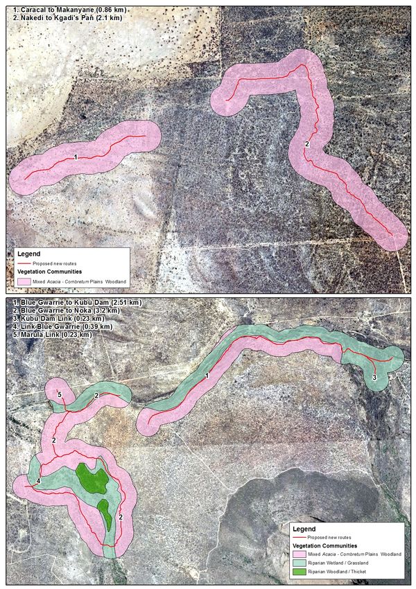
5.1.2.3 Riparian Woodland / Thicket
Riparian Woodland / Thicket is a fragmented vegetation community that is confined to the
banks and flood terraces of larger streams and rivers in the study area. Proposed roads that
may impact this community are Island Loop to Python Lower Road, Hamerkop to Seasonal
Road Crossing (Option 2), Blue Gwarrie to Noka Road, Link Blue Gwarrie and Marula Link,
while the two new massage Sala units are also in this vegetation community (Figures 6-9).
Vegetation structure varies from Tall Closed Woodland to Mid-High Thicket (Figure 4).
1
Raimondo et al. (2009) define “species of conservation concern” as those that are classified as
threatened (Critically Endangered, Endangered and Vulmnerable), those that are classified as Near
Threatened, and those species in the categories Declining, Rare and Critically Rare.
ECOREX Consulting Ecologists CC
18 Postnet Suite #192, Private Bag X2 Raslouw 0109
(083) 231-5632 warren@ecorex.co.zaMARATABA ECOLOGY STUDY & SENSITIVITY ASSESSMENT (ECOREX) APR 2018
Figure 4. Photographs of Riparian Woodland / Thicket
No species of conservation concern as defined by Raimondo et al. (2009)1 were found in
Riparian Woodland / Thicket during fieldwork. Only one protected tree species was located,
namely Spirostachys africana, which is protected under the Limpopo Environmental
Management Act (No. 7 of 2003) (Table 4). Riparian Woodland / Thicket is considered to be
Highly Sensitive as a result of its high functional value, particularly with regards to ecological
services such as riverbank stabilisation, flood attenuation, etc.
5.1.2.4 Riparian Grassland / Wetland
Riparian Grassland / Wetland occurs as a fragmented vegetation community in a mosaic with
Riparian Woodland / Thicket along the banks and flood terraces of larger streams and rivers
in the study area. Proposed roads that may impact this community are Island Loop to Python
Lower Road, Seasonal Road to Fish Eagle Dam, both Hamerkop to Seasonal Road Crossing
options, Proposed Bridge at existing Tusk Road Crossing, Blue Gwarrie to Noka Road, Link
Blue Gwarrie, Marula Link, Blue Gwarrie to Kubu Dam and Kubu Dam Link (Figures 6-8).
Vegetation structure varies from Low Closed to Open Grassland / Shrubland (Figure 5).
1
Raimondo et al. (2009) define “species of conservation concern” as those that are classified as
threatened (Critically Endangered, Endangered and Vulmnerable), those that are classified as Near
Threatened, and those species in the categories Declining, Rare and Critically Rare.
ECOREX Consulting Ecologists CC
19 Postnet Suite #192, Private Bag X2 Raslouw 0109
(083) 231-5632 warren@ecorex.co.zaMARATABA ECOLOGY STUDY & SENSITIVITY ASSESSMENT (ECOREX) APR 2018
Figure 5. Photographs of Riparian Grassland / Wetland
No species of conservation concern as defined by Raimondo et al. (2009)1 and no protected
species were found in Riparian Grassland / Wetland during fieldwork. This vegetation
community is considered to be Highly Sensitive as a result of its high functional value,
particularly with regards to ecological services such as riverbank stabilisation, flood
attenuation, etc.
1
Raimondo et al. (2009) define “species of conservation concern” as those that are classified as
threatened (Critically Endangered, Endangered and Vulmnerable), those that are classified as Near
Threatened, and those species in the categories Declining, Rare and Critically Rare.
ECOREX Consulting Ecologists CC
20 Postnet Suite #192, Private Bag X2 Raslouw 0109
(083) 231-5632 warren@ecorex.co.zaMARATABA ECOLOGY STUDY & SENSITIVITY ASSESSMENT (ECOREX) APR 2018
5.1.3 Conservation-Important Flora
Eighty-eight plant species were recorded within the vicinity of the proposed roads during
fieldwork (Appendix 1) of which five are protected by national and / or provincial legislation
(Table 3). Four species are protected under the National Forests Act (No. 30 of 1998), namely
Sclerocarya birrea subsp. caffra (low numbers present), Boscia albitrunca (moderate numbers
present), Acacia erioloba (moderate numbers present) and Combretum imberbe (moderate
numbers present). One species, Spirostachys africana, which is relatively common in the
study area, is protected the Limpopo Environmental Management Act (No. 7 of 2003).
Significant Spirostachys groves are present in the vicinity of Blue Gwarrie to Kubu Dam, Blue
Gwarrie to Noka Road, Tshukadu South Road Link, Graveyard to KD Plains, Woodcutter Road
A and Island Loop to Python Lower Road.
An additional 13 plant species of conservation concern have been recorded from the general
vicinity of the study area (Appendix 2), none of which are likely to occur because of unsuitable
habitat and / altitude.
Table 3. Protected plant species confirmed during fieldwork
Broad-leaved Woodland on
Mixed Acacia - Combretum
Riparian Woodland /
Plains Woodland
Protected Status
Hillslopes
Growth Thicket
Taxon
Form
Family Anacardiaceae
Sclerocarya birrea (A.Rich.) Hochst. subsp. caffra
Tree NFA x
(Sond.) Kokwaro
Family Capparaceae
Boscia albitrunca (Burch.) Gilg & Gilg-Ben. Tree NFA x x
Family Combretaceae
Combretum imberbe Wawra Tree NFA x
Family Euphorbiaceae
Spirostachys africana Sond. Tree LEMA x x x
Family Fabaceae
Acacia erioloba E.Mey. Tree NFA x
NFA = National Forests Act
LEMA = Limpopo Environmental Management Act
ECOREX Consulting Ecologists CC
21 Postnet Suite #192, Private Bag X2 Raslouw 0109
(083) 231-5632 warren@ecorex.co.zaMARATABA ECOLOGY STUDY & SENSITIVITY ASSESSMENT (ECOREX) NOV 2017
Figure 6. Vegetation communities within 200m buffer along proposed roads (1)
ECOREX Consulting Ecologists CC
22 Postnet Suite #192, Private Bag X2 Raslouw 0109
(083) 231-5632 warren@ecorex.co.zaMARATABA ECOLOGY STUDY & SENSITIVITY ASSESSMENT (ECOREX) APR 2018
Figure 7. Vegetation communities within 200m buffer along proposed roads (2)
ECOREX Consulting Ecologists CC
23 Postnet Suite #192, Private Bag X2 Raslouw 0109
(083) 231-5632 warren@ecorex.co.zaMARATABA ECOLOGY STUDY & SENSITIVITY ASSESSMENT (ECOREX) APR 2018
Figure 8. Vegetation communities within 200m buffer along proposed roads (3)
ECOREX Consulting Ecologists CC
24 Postnet Suite #192, Private Bag X2 Raslouw 0109
(083) 231-5632 warren@ecorex.co.zaMARATABA ECOLOGY STUDY & SENSITIVITY ASSESSMENT (ECOREX) APR 2018
Figure 9. Vegetation communities in the vicinity of the additional infrastructure units
ECOREX Consulting Ecologists CC
25 Postnet Suite #192, Private Bag X2 Raslouw 0109
(083) 231-5632 warren@ecorex.co.zaMARATABA ECOLOGY STUDY & SENSITIVITY ASSESSMENT (ECOREX) NOV 2017
5.2 Terrestrial Fauna
5.2.1 Mammals
The Marakele National Park, including the Marataba section, has high mammal diversity, with
91 species included in the official park checklist 1. However, this list includes numerous species
that are more likely to occur in grassland or rocky outcrop habitat at higher altitudes than the
Marataba section of the park, in which the proposed roads are located. Twenty of the species
known to occur in the Marataba section of the park are classified as either threatened
(Critically Endangered, Endangered or Vulnerable), Near Threatened, or are listed ToPS
species protected under the National Environmental Management: Biodiversity Act (No. 10 of
2004) (Appendix 5). Several of these species were recorded during fieldwork, such as
Aardvark Orycteropus afer (Protected), Spotted Hyaena Crocuta crocuta (NT), Leopard
Panthera pardus (VU) and Southern White Rhinoceros Ceratotherium simum simum (VU), but
all of the other species potentially occur in the vicinity of the proposed roads as well.
5.2.2 Birds
Of the nine biomes in Southern Africa, the savannah biome supports the highest diversity of
bird species within the sub-region. Marakele National Park has an official bird list of 315
species 2, although the quarter-degree grid in which the park is situated (2427 BC) has had
322 species recorded to date by the second Southern African Bird Atlas Projects (SABAP2) 3.
At a finer scale, data from SABAP2 indicate that 280 bird species have already been recorded
from the pentads (mapping units) in which the Marataba section of the park is situated
(2415_2730; 2415_2735; 2420_2730; 2420_2735)4. A pentad covers an area of
approximately 77 km2, which is considerably smaller than a quarter-degree grid
(approximately 694 km2) and thus a better indication of which species occur in the study area.
One hundred and thirty-four species were confirmed to occur in the study area during two
days’ fieldwork (Appendix 3), a reasonable total considering the dry conditions prevailing at
the time. The species accumulation curve displayed in Figure 10 indicates that further
sampling would have been needed to get an accurate estimate of species richness. However,
1
https://www.sanparks.org/docs/parks_marakele/mammal-list.pdf
2
https://www.sanparks.org/docs/parks_marakele/bird-list.pdf
3
http://sabap1.adu.org.za/sabap_site_summary.php?autoSite=SABAP&QDGC=2427BCaccessed
15/11/2017
4
Data accessed from http://sabap2.adu.org.za/ on 15/11/2017
ECOREX Consulting Ecologists CC
26 Postnet Suite #192, Private Bag X2 Raslouw 0109
(083) 231-5632 warren@ecorex.co.zaMARATABA ECOLOGY STUDY & SENSITIVITY ASSESSMENT (ECOREX) APR 2018
the data collected were sufficient in order to give broad descriptions of relevant bird
assemblages. Not all habitats within Marataba section were covered during fieldwork and this
should not be viewed as a description of assemblages within the entire section.
Figure 10. Species accumulation curve for November 2017 fieldwork
Two broad assemblages were evident during fieldwork and are described below. A third
assemblage is present, namely the Thicket Assemblage, but this was only briefly surveyed
and the only species confined to this assemblage during fieldwork was Yellow-bellied
Greenbul (Chlorocichla flaviventris).
I. Woodland Assemblage
This is the dominant bird assemblage over most of the Marataba section of the park and is
associated with the various woodland / savannah habitats present. Table 4 indicates the most
frequently encountered species in this assemblage during fieldwork, although insufficient time
was spent in the field to determine true species dominance. A number of species in this
assemblage are indicators of arid, Acacia-dominated savannahs, such as Crimson-breasted
Shrike (Laniarius atrococcineus), Ashy Tit (Melaniparus cinerascens), Southern Pied Babbler
(Turdoides bicolor) and Violet-eared Waxbill (Granatina granatina). One hundred and nine
species, or 81% of the fieldwork species list, were recorded in this assemblage (Appendix 3),
although the true species richness is likely to be significantly higher.
ECOREX Consulting Ecologists CC
27 Postnet Suite #192, Private Bag X2 Raslouw 0109
(083) 231-5632 warren@ecorex.co.zaMARATABA ECOLOGY STUDY & SENSITIVITY ASSESSMENT (ECOREX) APR 2018
Table 4. Most frequently encountered species in the Woodland Assemblage
Rep
Species Frequency
Rate
Rattling Cisticola 13 0.033
Long-billed Crombec 10 0.026
White-browed Scrub Robin 10 0.026
Cape Turtle Dove 9 0.023
Blue Waxbill 8 0.021
Grey Go-away-bird 8 0.021
Tawny-flanked Prinia 8 0.021
Black-backed Puffback 7 0.018
Grey-backed Camaroptera 7 0.018
Southern Red-billed Hornbill 7 0.018
II. Open Water / River Assemblage
This assemblage is confined to the Matlabas River and its various impoundments, such as
Fish Eagle Dam, Kingfisher Dam, etc. Thirty-two species, or 24% of the fieldwork list, were
recorded in this assemblage (Appendix 3) although very little time was spent surveying this
habitat. True species richness is likely to be significantly higher. Species composition includes
a number of distinctive feeding guilds such as open water feeders, e.g. White-faced Whistling
Duck (Dendrocygna viduata), Knob-billed Duck (Sarkidiornis melanotos) and White-breasted
Cormorant (Phalacrocorax lucidus), shoreline feeders such as Three-banded Plover
(Charadrius tricollaris), Wood Sandpiper (Tringa glareola) and Common Greenshank (Tringa
nebularia), emergent / fringing vegetation feeders such as African Jacana (Actophilornis
africanus), and aerial insectivores such as Lesser Striped Swallow (Hirundo abyssinica),
White-fronted Bee-eater (Merops bullockoides) and White-rumped Swift (Apus caffer).
Marakele National Park falls within the Waterberg System Important Bird Area (IBA) and
qualifies as a Global IBA under criteria A1, A3 and A4ii. IBA trigger species include globally
threatened species such as Cape Vulture Gyps coprotheres (818 active nests in 2013),
Secretarybird Sagittarius serpentarius, Martial Eagle Polemaetus bellicosus, Blue Crane
Anthropoides paradiseus and Denham's Bustard Neotis denhami, and regionally threatened
birds such as Verreauxs' Eagle Aquila verreauxii, White-bellied Korhaan Eupodotis
senegalensis, Lanner Falcon Falco biarmicus, African Grass Owl Tyto capensis and Tawny
Eagle Aquila rapax1.
1
http://www.birdlife.org.za/get-involved/join-birdlife-south-africa/item/148-sa007-waterberg-system
ECOREX Consulting Ecologists CC
28 Postnet Suite #192, Private Bag X2 Raslouw 0109
(083) 231-5632 warren@ecorex.co.zaMARATABA ECOLOGY STUDY & SENSITIVITY ASSESSMENT (ECOREX) APR 2018
Sixteen of the species known to occur in the Marataba section of the park are classified as
either threatened (Critically Endangered, Endangered or Vulnerable), Near Threatened, or are
listed ToPS species protected under the National Environmental Management: Biodiversity
Act (No. 10 of 2004) (Appendix 5). Three of these species, each of which is classified as
Vulnerable, were recorded during fieldwork, namely Black Stork, Martial Eagle and Lanner
Falcon. All of the remaining 13 species potentially occur in the vicinity of the proposed roads
as well, although most likely as irregular foraging visitors rather than residents. No evidence
of raptor nests was located along the transects walked.
5.2.3 Reptiles & Frogs
Forty-one reptile species have been recorded from the quarter-degree grid 2427 BC and
immediately adjacent grids 1, none of which are threatened (Critically Endangered,
Endangered or Vulnerable) or Near Threatened. One potentially occurring species of
conservation concern is Nile Crocodile (Crocodylus niloticus), which is classified as Vulnerable
and is listed as Vulnerable in the Threatened and Protected Species Lists in NEMBA. While it
is uncertain whether this species has been confirmed to occur in the Marataba section of the
park, there have been unconfirmed reports of sightings (Dr. A. Uys pers.comm.). Southern
African Python (Python natalensis), which is listed as Protected under NEMBA, does occur in
the Marataba section and potentially occurs at a number of the proposed roads, particularly in
the vicinity of river crossings. No reptiles were observed during the limited fieldwork period
and a dedicated reptile survey using pitfall traps and drift fences, as well as additional
nocturnal surveys, would be needed to adequately sample this faunal group.
Eighteen species of frogs have been recorded from the quarter-degree grid 2427 BC and
immediately adjacent grids 2, none of which are threatened (Critically Endangered,
Endangered or Vulnerable) or Near Threatened, and most of which are relatively widespread
habitat generalists. No frog species were recorded during fieldwork although no nocturnal
surveys were undertaken. Dedicated frog surveys during the wet season would result in a
small list of frogs within the vicinity of the proposed roads, but none of these are likely to be
species of conservation concern.
1
http://vmus.adu.org.za/vm_sp_list.php
2
http://vmus.adu.org.za/vm_sp_list.php
ECOREX Consulting Ecologists CC
29 Postnet Suite #192, Private Bag X2 Raslouw 0109
(083) 231-5632 warren@ecorex.co.zaMARATABA ECOLOGY STUDY & SENSITIVITY ASSESSMENT (ECOREX) APR 2018
6. SENSITIVITY ASSESSMENT
The ecological sensitivity of the proposed new roads was assessed on a sensitivity matrix as
indicated in Table 5 below. The score for each site is indicative of the potential biodiversity /
infrastructure development conflict, with higher scores indicating potentially higher conflict.
Most favourable sites are those with lower potential for conflict.
Table 5. Sensitivity Assessment of Proposed Roads
SENSITIVITY DRIVERS
SENSITIVITY SCORE
Potential for Negative
Potential to Support
Potential to Support
Associated Impacts
Presence of Unique
Red-Listed Species
Current Ecological
Irreplaceability of
Impact Footprint
Relative Size of
Natural Habitat
Habitat / Taxa
Biodiversity
PROPOSED ROADS AND CROSSINGS
State
Proposed Bridge at Existing Tusk Road Crossing 3 3 3 3 2 1 2 17
Graveyard to Gemsbok 3 4 4 2 2 2 2 19
Nakedi to Kgadi's Pan 3 4 4 2 2 3 2 20
Woodcutters Road Two 3 3 4 2 2 2 2 18
Woodcutters Road One 3 3 4 2 2 3 2 19
Tshukadu South Road Link 3 3 4 2 2 2 2 18
Coqui Maze Tshukadu South Link 3 4 4 2 2 2 2 19
Caracal to Makanyane 3 3 3 5 4 2 2 22
Graveyard to KD Plains 3 4 4 2 2 2 2 19
Hapoor Rhino Lookout Link 3 4 4 2 2 2 2 19
Seasonal Road to Fish Eagle Dam Wall 3 4 4 3 2 2 2 20
Island Loop to Python Lower Road 3 4 4 3 2 2 2 20
Blue Gwarrie to Noka 3 4 4 3 2 3 2 21
Link Blue Gwarrie 3 4 4 3 2 2 2 20
Marula Link 3 4 4 3 2 2 2 20
Dassie Road 3 4 4 3 2 2 2 20
Blue Gwarrie to Kubu Dam 3 4 4 2 2 3 2 20
Kubu Dam Link 3 4 4 3 2 2 2 20
Hamerkop to Seasonal Road Crossing 3 3 3 3 2 1 2 17
Hamerkop to Seasonal Road Crossing 3 3 3 3 2 1 2 17
Trails Lodge SALA and pathway 3 3 3 2 3 1 2 17
Trails Lodge Staff Units 2 2 2 2 2 1 2 13
Trails Lodge Accommodation Unit 3 3 3 2 2 2 2 17
Safari Lodge SALA 2 2 2 2 3 1 2 14
OVERALL SENSITIVITY
SENSITIVITY DRIVER SCORE
SCORE
1 = Very low / Negligible 7-10 = Very low / Negligible
2 = Low 11-15 = Low
3 = Moderate 16-20 = Moderate
4 = High 21-25 = High
5 = Very High 26-35 = Very High
ECOREX Consulting Ecologists CC
30 Postnet Suite #192, Private Bag X2 Raslouw 0109
(083) 231-5632 warren@ecorex.co.zaMARATABA ECOLOGY STUDY & SENSITIVITY ASSESSMENT (ECOREX) APR 2018
7. KEY POTENTIAL IMPACTS
This section gives a brief overview of expected impacts of the proposed roads and additional
infrastructure units on terrestrial ecosystems. Impacts are not arranged in any order of overall
significance, and this is not a detailed impact assessment as this was not part of the terms of
reference for this report. The following are potentially significant impacts on untransformed
vegetation communities:
• Loss or damage of plant species of conservation importance – five protected
species could be impacted during the construction phase. Four of these are protected
under the NFA (Sclerocarya birrea subsp. caffra, Combretum imberbe, Acacia erioloba
and Boscia albitrunca), while Spirostachys africana is protected under provincial
legislation;
• Degradation of vegetation on sodic / duplex soils – one of the proposed roads
(Caracal to Makanyane) crosses a significant area of sodic / duplex soils; any road
construction over these soils is likely to result in long-term / permanent damage to that
environment and is not recommended;
• Degradation of watercourses – the proposed river crossings, particularly along the
Matlabas River, are potentially sensitive to degradation through construction, road
building and dumping of building rubble and topsoil. Long-term changes in surface and
subsurface runoff could negatively affect the structure and function of this system,
particularly with respect to channel erosion caused by increased stormwater runoff;
• Invasion of natural habitat by alien plants – although few alien plant species were
located during fieldwork, construction activities could introduce seeds of pioneer alien
plants which may thrive in bare soil exposed during construction.
ECOREX Consulting Ecologists CC
31 Postnet Suite #192, Private Bag X2 Raslouw 0109
(083) 231-5632 warren@ecorex.co.zaMARATABA ECOLOGY STUDY & SENSITIVITY ASSESSMENT (ECOREX) APR 2018
8. CONCLUSION & RECOMMENDATIONS
The terrestrial ecology of the proposed road sites was sampled over a three-day period in
November 2017. While few species of conservation were noted during fieldwork, numerous
threatened mammals and birds are known to occur, either as breeding residents or non-
breeding visitors. Two sensitive vegetation communities were encountered, namely Riparian
Woodland / Thicket and Riparian Grassland / Wetland, while areas of sodic / duplex soils
within the Mixed Acacia – Combretum Plains Woodland community are also considered to be
sensitive. A sensitivity assessment matrix is presented in section 6, on which the following
recommendations can be made with regards to the location and construction of the proposed
roads:
• The proposed Caracal to Mankanyane road crosses a significant portion of sodic /
duplex soils and would result in irreparable damage to the soils and associated
vegetation; construction of this road is not recommended.
• Part of the proposed Blue Gwarrie to Noka road is aligned in close proximity to steep
eroded banks of the stream it follows, and as a result has scored high in the sensitivity
assessment; the road will need to be carefully re-aligned in this section to avoid further
erosion of these banks.
• The location of roads should be above the 1/100-year floodline of the Matlabas River
wherever possible; it is understood that several seasonal roads are needed below this
floodline, but this should be limited to three options or less.
• Road construction should not impact any large indigenous trees, especially protected
species such as Acacia erioloba, Sclerocarya birrea subsp. caffra, Combretum
imberbe, Boscia albitrunca and Spirostachys africana.
• All proposed roads to contain adequate stormwater drainage and erosion control
measures.
• It is assumed that no external labour teams will be used for road construction. If this is
the case, then poaching should not be a significant threat.
• Areas of bare soil exposed during road construction should be regularly monitored
during the construction phase to ensure that no invasive plants get established.
Provided the recommendations suggested in this report are followed, there is no objection to
the proposed development of roads and additional infrastructure on Marataba in terms of the
terrestrial ecosystems of the study area.
ECOREX Consulting Ecologists CC
32 Postnet Suite #192, Private Bag X2 Raslouw 0109
(083) 231-5632 warren@ecorex.co.zaMARATABA ECOLOGY STUDY & SENSITIVITY ASSESSMENT (ECOREX) APR 2018
9. REFERENCES
Animal Demography Unit. n.d. The Southern African Bird Atlas Project
http://sabap2.adu.org.za/index.php accessed on 08/05/2017.
Bates, M.F., Branch, W.R., Bauer, A.M., Burger, M., Marais, J., Alexander, G.J. & de Villiers,
M.S. (eds). 2014. Atlas and Red Data List of the Reptiles of South Africa, Lesotho and
Swaziland. Suricata 1. South African National Biodiversity Institute, Pretoria.
DEA. 2014. National Environmental Management: Biodiversity Act 2004 (Act 10 of 2004) Alien
and Invasive Species Lists. Government Gazette.
DEAT. 2011. National List of Threatened Terrestrial Ecosystems in South Africa. National
Environmental Management: Biodiversity Act (Act 10 of 2004). Government Gazette.
Desmet, P. G., Holness, S., Skowno, A. & Egan, V.T. 2013. Limpopo Conservation Plan v.2:
Technical Report. Contract No EDET/2216/2012. Report for Limpopo Department of
Economic Development, Environment & Tourism (LEDET) by ECOSOL GIS.
Edwards, D. 1983. A broad-scale structural classification of vegetation for practical purposes.
Bothalia 14:705-712.
Hahn, N. 2002. Endemic flora of the Soutpansberg. MSc Thesis. University of KwaZulu-Natal,
Pietermaritzburg.
Minter, L.R., Burger, M., Harrison, J.A., Braack, H.H., Bishop, P.J. & Kloepfer, D.2004. Atlas
and Red Data Book of the Frogs of South Africa, Lesotho and Swaziland. SI/MAB
Series No.9. Smithsonian Institution, Washington, DC.
Mucina, L. and Rutherford, M.C. (eds) 2006. The Vegetation of South Africa, Lesotho and
Swaziland. Strelitzia 19. South African National Biodiversity Institute, Pretoria.
Raimondo, D., Von Staden, L., Foden, W., Victor, J.E., Helme, N.A., Turner, R.C., Kamundi,
D.A. & Manyama, P.A. (eds) 2009. Red List of South African Plants 2009. Strelitzia 25.
South African National Biodiversity Institute, Pretoria.
Swanepoel, L.H., Balme, G., Williams, S., Power, R.J., Snyman, A., Gaigher, I., Senekal, C.,
Martins, Q., Child, M.F. 2016. A conservation assessment of Panthera pardus. In Child
MF, Roxburgh L, Do Linh San E, Raimondo D, Davies-Mostert HT, editors. The Red
List of Mammals of South Africa, Swaziland and Lesotho. South African National
Biodiversity Institute and Endangered Wildlife Trust, South Africa.
Taylor, M.R., Peacock, F., Wanless, R.W. (eds). 2015. The Eskom Red Data Book of Birds of
South Africa, Lesotho and Swaziland. Birdlife South Africa, Johannesburg.
Van Wyk, A. E. & Smith, G. F. 2001. Regions of floristic endemism in southern Africa: A review
with emphasis on succulents. Umdaus Press, Pretoria.
ECOREX Consulting Ecologists CC
33 Postnet Suite #192, Private Bag X2 Raslouw 0109
(083) 231-5632 warren@ecorex.co.zaYou can also read