Middlesex University and The Burroughs Supplementary Planning Document - Transport Study
←
→
Page content transcription
If your browser does not render page correctly, please read the page content below
Middlesex University and The Burroughs SPD
                                              Transport Study

Middlesex University and The Burroughs
Supplementary Planning Document
Transport Study
May 2020

  Page 1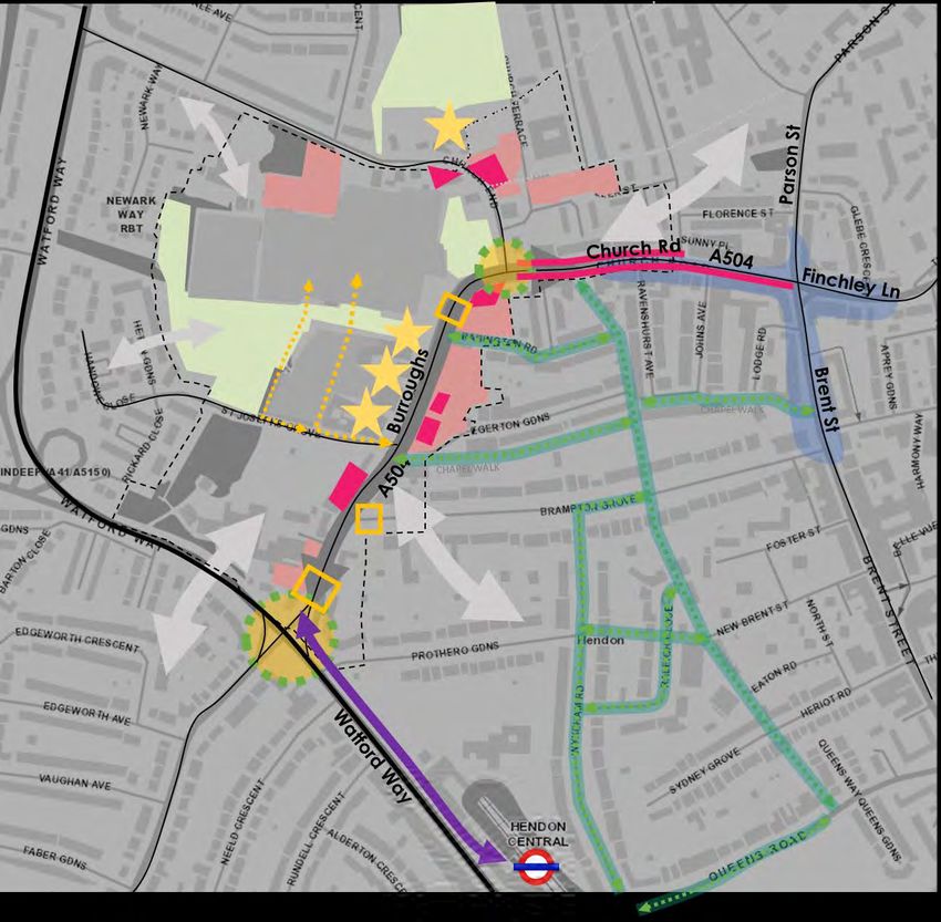
Middlesex University and The Burroughs SPD
                                                                    Transport Study

1   Introduction

    General introduction

    Urban Flow has been commissioned by Barnet Council to prepare a transport study in
    support of a Supplementary Planning Document (SPD) for Middlesex University and the
    Burroughs area in Hendon.

    Figure 1 identifies the SPD area boundary and specific sites indicated for potential
    future development.

    Figure 1 SPD boundary with proposed development sites

    Page 2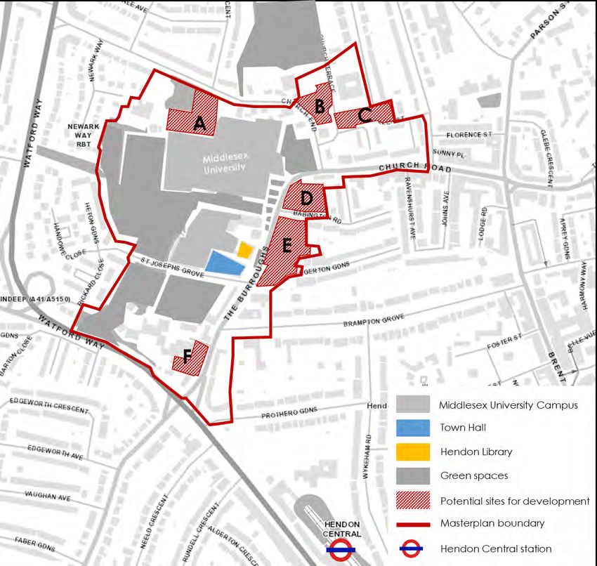
Middlesex University and The Burroughs SPD
                                                                   Transport Study

Definition and scope of the SPD Transport Study

This transport study:

    •    Provides a detailed overview of the transport and movement context in The
         Burroughs study area and the wider Hendon area;
    •    identifies issues and potential opportunities for change to support the SPD area,
         focussing in particular on The Burroughs/Church Road corridor;
    •    reviews the existing policy context at a borough and London scale;
    •    identifies overarching SPD transport objectives;
    •    outlines proposed SPD development opportunities;
    •    assesses the transport/movement implications of the proposed SPD
         development sites; and
    •    outlines a range of transport measures and interventions for the future.

Page 3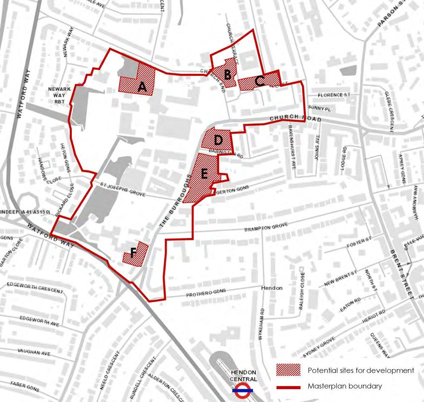
Middlesex University and The Burroughs SPD
                                                                             Transport Study

2   Existing transport and movement context

    This section of the report provides an overview, by mode, of the existing transport and
    movement context within, and immediately surrounding, the SPD study area.

    A detailed ‘baseline appendix’ is provided at the end of this report; this explores key
    issues in more detail. Primary data sources include site audits, data collected
    specifically for this study (including parking activity), other available data held by
    Barnet Council and Transport for London’s (TfL’s) ‘Playbook’ and ‘City Planner’ tools.

    Walking

        •    High levels of walking are observed within the SPD boundary – however, the
             pedestrian environment is of poor quality and does not align with Healthy
             Streets aspirations in multiple locations along the corridor
        •    Watford Way – The Burroughs junction creates an intimidating environment for
             pedestrians. Pedestrians are not prioritised an infrastructure does not satisfy the
             demand during peak times
        •    Due to narrow effective footway widths, poor paving quality and street clutter,
             multiple sections of the Burroughs and Church Road are not wheelchair
             accessible and present challenges to pedestrians with other mobility
             impairments
        •    Pedestrian provision along residential roads is typically no better than adequate
             and often dominated by on-street parking
        •    The secluded nature of several pedestrian links (West View, Chapel Walk) leads
             to perceived (and potentially actual) safety concerns
        •    There is poor crossing provision along The Burroughs, Church Road and Church
             End which forces pedestrians to cross in ad-hoc locations
        •    More positively, the pedestrian environment in front of the Middlesex University
             Campus has been renovated – wide footways, quality paving and greenery
             create a comfortable space for people walking

    Watford Way underpass               West View linkage poorly lit with   Church Road with narrow
    presents intimidating environment   limited natural surveillance        footways

    Page 4
Middlesex University and The Burroughs SPD
                                                                     Transport Study

Cycling

    •    Low levels of cycling are observed within the SPD boundary – this is attributed
         to a combination of factors including lack of designated provision, hilly terrain
         and higher car-dependency within the borough
    •    Vehicle domination impacts on the comfort and safety of cyclists
    •    Due to a lack of appropriate provision, junctions can be hazardous for cyclists,
         with Watford Way being particularly problematic due to multiple lanes of fast-
         moving traffic
    •    There is very limited cycle parking provision within the SPD area - although there
         is some private cycle parking available on the Middlesex University Campus
    •    The hilly nature of the routes within the SPD area (and beyond) makes cycling
         a less attractive proposition than might otherwise be the case
    •    On-street parking along residential streets (Brompton Grove, Egerton Gardens,
         Babington Road) narrows effective widths and impacts on cyclist comfort
    •    There is limited wayfinding signage around the site makes it challenging for
         cyclists to navigate
    •    Based on Transport for London’s Transport Classification of Londoners, there is a
         good potential for behaviour change within the SPD area (switch to active
         travel)

No on-street cycle provision    Cycling within the University   Cycling banned on Chapel Walk
along The Burroughs             campus                          connection

Public Transport

    •    The SPD area is located within walking distance to Hendon Central station – the
         Northern line connecting to key destinations including Brent Cross, Camden,
         Euston, Kings Cross and central London
    •    There is limited capacity at Hendon Central tube station during peak periods
    •    There is a good bus provision, with 6 routes running along The Burroughs /
         Church Road corridor (including two ‘600’ school services) and additional 5
         routes accessible within walking distance (including one night service)
    •    The SPD area has mixed PTAL ratings - The Burroughs up to the Middlesex
         University campus scores 4 (average) whilst Church Road and the surrounding
         residential neighbourhoods score lower - 2 (poor)
    •    The area along Watford Way and by Hendon Central station has higher PTAL
         ratings of 5-6a (best), primarily due to the proximity to the underground station
         and good provision of frequent bus services
    •    Vehicle congestion and queueing during peak times along The Burroughs and
         Church Road impacts on bus speed and service reliability

Page 5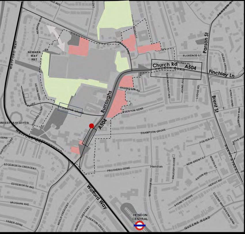
Middlesex University and The Burroughs SPD
                                                                    Transport Study

    •    The volume of stopping buses by Middlesex University Campus occasionally
         results in ‘bus-walls’ which contribute to congestion and a poor-quality
         pedestrian and cyclist environment
    •    Bus stop O (on The Burroughs) operates five bus routes and acts as an de facto
         interchange. Groups of waiting passengers have significant impact on the
         effective width of the footway and create a pinch-point impeding pedestrian
         through movement

Peak hour congestion on         Watford Way strategic route     Goods vehicle activity
The Burroughs

Schematic route plans are included in the ‘baseline appendix’.

Highway network and parking

    •    There is vehicle domination along The Burroughs and Church Road corridor
         especially during peak times, resulting in higher collision risks and which impacts
         negatively on the perception of road safety
    •    Church Road has a high ‘place’ potential, yet due to unfavourable traffic
         management, acts primarily as a link for vehicle traffic
    •    Due to poor cycling and walking provision all junctions are hazardous for cyclists
         and pedestrians
    •    Due to congestion along the main corridor, rat-running has been identified a
         problem on residential roads, particularly at peak times
    •    On-street parking dominates the streetscape along residential streets
    •    Poor management of deliveries and servicing and lack of designated loading
         bays impacts on negatively on Church Road
    •    Off-street car parks are typically underutilised

Peak hour congestion on         Watford Way strategic route     Goods vehicle activity
The Burroughs

These issues (and opportunities) have been critically reviewed and incorporated into a
range of SPD transport objectives (Chapter 4) and then specific measures and
interventions (Chapter 7).

Page 6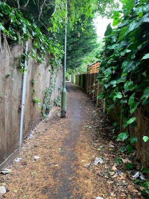
Middlesex University and The Burroughs SPD
                                                                       Transport Study

3   Policy and best practice

    This section provides an overview of the current national and local government policies
    that have, and will continue to, inform the development of this study. Reviewing these
    policies helps to ensure that the SPD is developed and implemented in accordance
    with established policy aims and objectives.

    London Policies

    London Plan (2020 ‘Intend to Publish’)

       •     Development Plans should deliver patterns of land use that
             facilitate residents making shorter, regular trips by walking
             or cycling
       •     More active traffic management, including demand
             management measures
       •     Closer coordination of transport policy and investment
       •     An appropriate balance being struck between promoting
             new development and preventing excessive car parking
             provision that can undermine cycling, walking and public transport use

    A City for All Londoners

       •     Roadmap to become a zero-carbon city by 2050
       •     Aim to drastically reduce dangerous emissions
       •     Vibrant town centres and high streets
       •     Short journeys on foot or bike
       •     More space for pedestrians
       •     ‘Turn up and go’ bus and rail services
       •     More efficient road network and less traffic on local roads
       •     Reduced car use

    Mayor of London’s Transport Strategy

       •     Improving walking and cycling environments and
             providing better bus and rail services will reduce car
             dependency
       •     Healthy Streets and Healthy People
       •     Safe, secure, clean and green streets
       •     Well-connected, accessible and safe public transport
       •     High density, mixed-use developments
       •     People choose to walk and cycle
       •     Car-free and car-lite places
       •     Carbon-free travel
       •     Efficient freight

    Page 7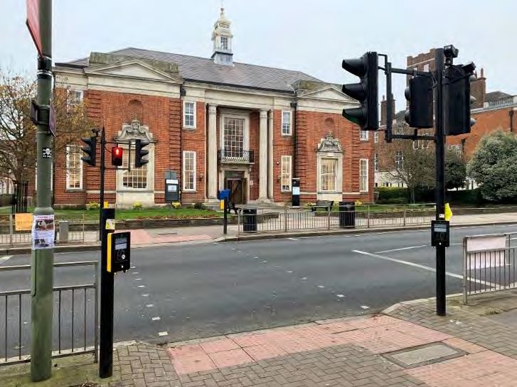
Middlesex University and The Burroughs SPD
                                                                     Transport Study

Vision Zero

   •     Safe speeds - Lowering speeds is fundamental to reducing
         road danger because a person is five times less likely to be
         fatally injured if hit at 20mph than at 30mph
   •     Safe street design - Ensuring all transport infrastructure
         projects in London contribute to reducing road danger;
         attention will focus particularly on areas of highest risk such
         as busy junctions and roundabouts
   •     Safe vehicles - Making sure those vehicles that need to use
         London’s streets are as safe as possible
   •     Safe behaviour - Improving the behaviour of all road users, especially drivers of
         motorised vehicles
   •     Post collision - Reducing the severity of injuries when a collision occurs,
         supporting victims of road crime, and developing a clearer picture of how and
         why collisions occur

Healthy Streets

         Healthy Streets approach is a framework that underlines Mayor’s Transport
         Strategy. Its objectives include improving air quality, reducing congestion and
         supporting London’s communities to be greener, healthier and more attractive
         places to live, work, play and do business.

         This can be achieved by considering Healthy Streets indicators in order to
         improve the experience of using London’s streets and encourage people to
         spend time there:

         Figure 2 Healthy Streets Indicators

         •    Pedestrians from all walks of life – streets should be inclusive and reflect the
              full diversity of society
         •    Easy to cross - high quality provision of suitable crossing facilities can make
              walking and cycling more appealing

Page 8
Middlesex University and The Burroughs SPD
                                                                    Transport Study

         •   Shade and shelter – protection from extreme conditions can encourage
             people to travel actively irrespective of the weather
         •   Places to stop and rest – resting places are essential part of inclusive design,
             and can bring benefit to local businesses and communities, by
             encouraging people to spend time and socialise
         •   Not too noisy – less traffic-related noise, achieved by reducing motor
             vehicle dominance, can encourage people to interact and travel actively
             and improve their health and well-being
         •   People choose to walk, cycle and use public transport – cycling, walking
             and public transport should be the most attractive and enjoyable travel
             modes
         •   People feel safe – people should feel safe on the streets at any time of day
             and night. Perception of crime and road safety concerns might discourage
             them from active travel and public transport
         •   Things to see and do – an attractive offer of local facilities and services can
             encourage people to travel actively and be less car-dependent
         •   People feel relaxed – good quality urban design and clean, well-
             maintained spaces can reduce stress and encourage people to walk and
             cycle
         •   Clean air – improved air quality, achieved by reducing the number of
             polluting vehicles, helps reduce health inequalities, improve health and
             well-being

London Borough of Barnet

At a more local, Borough level there is a wide range of relevant policies and strategies
that relate to growth, transport and other related considerations.

Barnet’s Draft Local Plan (2020)

At the time of writing (March 2020), Barnet Council is undertaking
Regulation 18 consultation on a Draft Local Plan Preferred
Approach. The new Local Plan “sets out a vision for how Barnet
will change as a place over the next 15 years and forms a
strategy which emphasises the borough’s attractiveness as a
place to live, work and visit.”

Key draft transport policies are:

   •     Policy TRC01 – support [TfL’s] Healthy Streets Approach,
         improving street lighting, security coverage and accessibility along new walking
         and cycling routes, transport interchanges and around bus stops
   •     Policy TRC02 – promote delivery of new transport infrastructure to support the
         travel needs of a growing population
   •     Policy TRC03 – expect development to provide parking in accordance with
         London Plan standards, except in the case of residential development

Page 9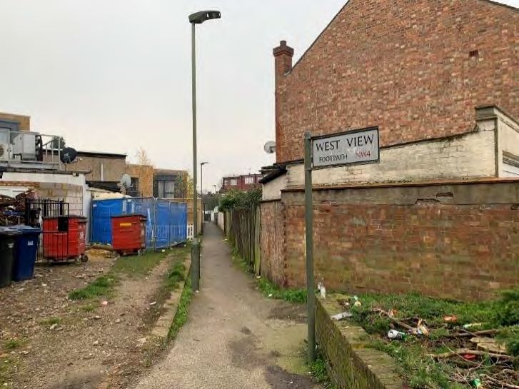
Middlesex University and The Burroughs SPD
                                                                   Transport Study

Barnet’s Local Plan (2012)

   •   Protecting Barnet’s character and amenity, by promoting
       development that respects local context and distinctive
       character
   •   High-quality, accessible and inclusive design
   •   Reducing the borough’s carbon footprint where possible
       particularly in new development
   •   Protecting and enhancing Barnet’s heritage – with The
       Burroughs and Church End listed as one of the
       Conversation Areas
   •   The council expects proposals for student accommodation to demonstrate
       that they support educational establishments within Barnet and meet an
       identified local need. Provision for students should be located in accessible
       locations
   •   Ensuring a suitable mix of appropriate uses as part of development within the
       town centres to support their continued vitality and viability
   •   Maintaining local centres and parades
   •   Enabling inclusive and integrated community and education facilities and uses
   •   Protecting and enhancing Barnet’s open spaces
   •   Providing safe, effective and efficient travel
   •   Ensuring more efficient use of the local road network and delivering more
       environmentally friendly transport networks
   •   Taking a comprehensive approach to tackling school run
   •   Improving health and well-being

At the time of this SPD being prepared (March 2020), Barnet Council is reviewing and
updating the Borough’s planning policies in a new, revised Local Plan. The first
‘preferred policy approach’ stage of this process is currently underway. The new Local
Plan will eventually replace the existing Local Plan, currently expected in late 2021.

One Barnet: A Sustainable Community Strategy for Barnet (2010 - 2020)

   •   This strategy document aims to ensure that Barnet
       remains a successful London suburb – delivering
       sustainable housing growth, keeping Barnet moving,
       supporting enterprise, providing people with the
       right skills to access employment opportunities,
       creating an environmentally responsible, clean and
       green suburb
   •   Strong, safe communities for everyone – reducing crime and anti-social
       behaviour and ensuring that residents feel safe, creating strong and cohesive
       communities
   •   Investing in children, young people and families – ensuring safety of children
       and young people, narrowing the gap through targeting at young people at
       risk of not fulfilling their potential, preventing ill health and unhealthy lifestyles
   •   Healthy and independent living - ensuring better health and healthy lives for
       all and better access to local health services, promoting choice and
       maximising independence of those needing greatest support

Page 10
Middlesex University and The Burroughs SPD
Transport Study
Draft Local Implementation Plan (LIP) (2018)
• The Draft LIP shares many objectives articulated in the Mayor’s Transport
Strategy – but acknowledging that Barnet presents unique challenges that may
require alternative solutions
• Encouraging healthier lifestyles through promoting physical activity, enabling
supporting and promoting active travel and improving public transport links to
facilities
• Applying Healthy Streets principles
• Seeking to achieve the Vision Zero ambition of zero Killed or Seriously Injured
Road Traffic Casualties by 2041
• Promoting, enabling and supporting more sustainable travel to school,
workplaces and other destinations
• Improving air quality in Barnet and protecting residents and visitors, especially
children from exposure to pollution
• Securing new and revised public transport routes to support the growth of the
borough, particularly addressing the challenges presented by orbital travel and
travel to neighbouring areas and orbital connectivity across the borough
• Facilitating the introduction of step-free facilities at stations and accessible bus
stops to help make public transport accessible for all passengers, directly or
through support of TfL and National Rail proposals and development
opportunities
• Securing significant regeneration and growth across the borough’s opportunity
areas based upon sustainable development principles with the majority of trips
carried out via public transport on foot and by cycle with a reduced reliance
on the private car
Air Quality Action Plan (2017 – 2022)
• Barnet’s Air Quality Action Plan aims to raise awareness of the causes of
pollution and to drive behavioural change as well as to reduce exposure to air
pollution
• Reducing the impact of delivery servicing and freight
• Promoting cleaner transport
• Encouraging a change to walking, cycling and ultra-low emission vehicles
(such as electric)
Draft Barnet Long-term Transport Strategy (2019)
• The Long-term Transport Strategy contains a clear
vision statement: ‘By 2041, Barnet will have an
efficient, convenient and reliable transport network,
which enables safe, healthy and inclusive travel,
protects the natural environment and supports the
borough’s growth. The network will have transformed
the way people and goods travel, providing strong
orbital and radial links which gives everyone a
choice of transport modes to complete their journey
regardless of age, ability or income’
Page 11Middlesex University and The Burroughs SPD
Transport Study
• Five key objectives have been identified in order to achieve this vision:
1. Transport in Barnet keeps the borough moving, enabling people and goods
to move within and beyond the borough efficiently using high quality orbital
and radial links.
2. The transport system is as accessible as possible regardless of age, ability
and income, and the negative impacts of transport are limited.
3. Transport contributes positively to the health of the borough, by prioritising
active travel and ensuring continued improvement in air quality.
4. The road network and transport system in Barnet is safe and residents and
visitors feel safe across all transport modes.
5. Barnet’s transport network contributes to the creation of better places to
live and work, allows local businesses to thrive sustainably, and is flexible,
adapting to future opportunities presented by technology and change in
travel patterns.
Barnet Corporate Plan (2019 – 2024)
• The latest Corporate Plan seeks to achieve three main
outcomes:
• ‘A pleasant, well maintained Borough that we
protect and invest in’
• ‘Our residents live happy, healthy, independent
lives with the most vulnerable protected’
• ‘safe and strong communities where people get
along well’
• The plan seeks to keep the borough moving, including
improvements to roads and pavements – achieved through improving the
condition of our roads and pavements, encouraging the use of public
transport, walking and cycling through the ‘healthy streets’ approach, lobbying
for improvements to public transport and bringing back disused public transport
such as rail lines, developing a cycle network to major destinations in the
borough without impeding main traffic routes, promoting and continuing to roll
out electric vehicle charging and car clubs, using enforcement to increase
compliance and support traffic to move smoothly and safely.
• Supporting our residents who are older, vulnerable or who have disabilities, to
remain independent and have a good quality of life
• Encouraging residents to lead active and healthy lifestyles and maintain their
mental wellbeing
• Tackling anti-social behaviour and environmental crime
• Supporting local businesses to thrive
Barnet Growth Strategy (2019 – 2024)
• The Growth Strategy sets out the Council’s role and priorities for regeneration,
development and business, employment and skills activity across the borough
from 2019 to 2030, including:
Page 12Middlesex University and The Burroughs SPD
Transport Study
• Enabling new and enhanced public transport connections
by improving orbital connectivity and interchange
between rail lines, reducing congestion and improving
transport accessibility
• Delivering healthier street design to support all forms of
travel by responding to demographic and cultural
changes to enhance travel choices, promote active travel
and improve safety
• Delivering a cleaner, greener and more pleasant borough
by reduced congestion and improved air quality, by encouraging the use of
more sustainable forms of transport and supporting the transition to electric
vehicles and other technologies as the emerge
• Implementing state-of-the-art digital infrastructure by working with public and
private sector partners to incorporate this into regeneration schemes, council
assets and where local employers need it, such as across our town centres.
Summary
There is a wide range of relevant policies and strategies that relate to growth,
transport and other related considerations. In particular, Barnet Council’s vision for
transport in the borough shares many of the same goals articulated in the Mayor’s
Transport Strategy (MTS) - including improving air quality, reducing car dependency,
and enabling more Londoners to walk and cycle.
Figure 31 shows a summary of this close overlap between the MTS and Barnet
Council’s Local Implementation Plan (LIP).
Figure 3 Policy objectives summary: MTS & LIP
1
Sourced from: Draft Long-term Transport Strategy, Barnet Council, November 2019
Page 13Middlesex University and The Burroughs SPD
Transport Study
4 SPD transport objectives
Based on existing conditions and policy context, and in line with Healthy Streets
Approach, the following transport objectives have been established:
• Transforming The Burroughs into a multi-
modal corridor with focus on safety and
‘place-making’ by encouraging active
travel and reducing vehicle domination
• Creating a place that is inclusive,
accessible and can be enjoyed by
everyone
• Improving pedestrian and cycle
connections
• Improving quality of public realm and
public spaces
• Promoting a safer and more secure
environment for all road users including
pedestrians and cyclists
• Rationalising parking with a medium/ long-term reduction and supporting car-
free development
• Boosting health and well-being of local community through better air quality
and lower noise levels
• Improving bus speeds and reliability
• Enhancing local character and heritage through improved connectivity
• Integrating Middlesex University campus and new developments with local
environment and community
• Creating a clear role for local high street (Church Road and Brent Street)
• Realising the potential of Grove Park and Sunny Hill Park
Page 14Middlesex University and The Burroughs SPD
Transport Study
5 SPD development proposals
Within the SPD study area, eight potential development sites have been identified
(labelled A-F in Figure 4).
Figure 4 Map of proposed developments within the SPD boundary
These potential development sites are focussed on The Burroughs corridor (sites D and
E) and to the north of the study area (site A-C). Table 1 overleaf provides an overview
of the assumed development proposals that have been used to inform this SPD
transport study.
These development assumptions have been used to test a possible scale of change
within the SPD area and investigate what the potential impacts may be. All of these
assumptions are subject to change ahead of actual planning permissions being
sought.
No longer-term change in student numbers at the University of Middlesex is anticipated.
As such, the scale of movement to/from/within the campus is assumed to be essentially
unchanged. The SPD should however respond positively in the future to improving
access/movement to/from the campus and its integration with the local area.
Page 15Middlesex University and The Burroughs SPD
Transport Study
Plot Existing use Proposed Quantum Commentary
SPD use
No plans to
A University car park No change n/a develop within the
SPD timeframe
In the order of 300
student housing
Student units assumed
B Meritage Centre
housing Possible
reprovision of 4
residential units
Community Re-provision of
C PDSA site
uses community uses
No plans to
Usher Hall – student
D No change n/a develop within the
housing
SPD timeframe
Fenella to Edgerton In the order of 500
Gardens car park student housing
Student units assumed,
housing, three retail units,
E University
retail, small 100-seat theatre,
administration /
theatre reprovision of
officers, retail units,
council car park c.122 car park
spaces
No plans to
F Car parks No change n/a develop within the
SPD timeframe
Table 1 Proposed SPD development sites
Of the potential development sites, B (Meritage Centre), C (PDSA site) and E (land
between Babington Road and Egerton Gardens) are expected to come forward first.
Cumulative development assumptions
The combined, cumulative nature of the proposed SPD developments is summarised
below. Overall, the combined SPD development proposals are for the retention of
existing residential, retail and community uses, the creation of in the order of 800
student accommodation units, and a new small (c.100 seat) theatre.
Page 16Middlesex University and The Burroughs SPD
Transport Study
Combined testing
Plot Change? Development summary
assumptions
A N No change proposed No change assumed
Net +300 student units
Replace community uses with
c.300 students units and c.14 No net change resi units
B Y
parking spaces and re-provide
4 resi units No net change in community
use (see plot C)
Reprovision of community uses
C Y from Plot B and retention of No net change (see plot B)
PDSA use
D N No change proposed No change assumed
Net +500 student units
New theatre (100 seat)
New theatre, c.500 student resi
No change retail units
E Y units, 3 retail units, retain c.122
parking spaces
No change car parking
Net no change university
campus accommodation
F N No change proposed No change assumed
+800 student units
All sites
New theatre (100 seat)
No net change to existing
residential, retail and
community uses
Table 2 Combined SPD development assumptions
Summary
A conservative worst-case assumption will be that the existing retained uses will not
generate additional movement activity over and above what currently takes place;
there is however clear scope to promote sustainable trip making activity (walking,
cycling, public transport) to reduce private car use.
The creation of new student accommodation in close proximity to the University of
Middlesex’s campus will see students living within easy walking distance of the key local
destination.
Page 17Middlesex University and The Burroughs SPD
Transport Study
Currently students travel to the campus from a broad local and north London
catchment which is reflected with a mixture of walking, public transport and car use.
The creation of this new student housing, combined with no overall change in university
student numbers, will be for in the order of 800 students to switch travel mode from
public transport / car / cycling to primarily walking. This is shown schematically in Figure
5. As such, this element of the SPD development proposals is likely to be net positive in
terms of reducing vehicle trip making on the highway network and reduced pressure
on peak time public transport services.
Movement
to/from the
campus from
outside the
SPD area
Movement
to/from the
campus
internalised
within the
SPD area
Figure 5 Schematic diagram of student travel patterns
Page 18Middlesex University and The Burroughs SPD
Transport Study
6 SPD developments impact assessment
This section provides an overview of the technical analysis undertaken to test the likely
impact of the proposed SPD developments. More detail is provided in the ‘impact
assessment appendix’ at the end of this document.
The assessment undertaken followed a conventional, sequential approach:
Trip generation > Trip distribution > Trip mode > Trip assignment
The impact of the new student housing and theatre are considered separately.
Student accommodation – existing
Because there is no increase in student numbers at the university these trips are not
new, merely redistributed. As explained in the previous chapter (Figure 4), the
distribution of these trips will change from being external to the SPD area (existing) to
within the SPD area (proposed). Because of this, an assessment has been undertaken
to investigate what the existing and proposed demand by mode will be for those
students residing in the assumed 800 units proposed in the SPD area.
Trip generation for student accommodation has been estimated using the industry-
standard TRICS database2. On an average weekday (7am-9pm) it can be expected
that each student accommodation unit generates just over one trip. When scaled up
to the assumed number of 800 units, this gives:
• Approximately 920 journeys per day – both outbound and inbound
• In a typical hour (9am-6pm) up to 80 journeys could be made inbound and
outbound, equivalent to just over one per minute
Existing mode share assumptions were extracted from the most recent University of
Middlesex Travel Plan (2016) when the latest student and staff travel survey was
completed:
• Walk = 33%
• Cycle = 2%
• Public transport = 53%
• Car driver = 9%
• Car passenger = 2%
• Other eg motorcycle = 1%
2
http://www.trics.org/how_2_use.aspx
Page 19Middlesex University and The Burroughs SPD
Transport Study
Public Car Car
Walk Cycle Other Total
Transport driver passenger
Total
300 20 490 80 20 10 920
(7am-9pm)
Typical hour 27 2 41 7 2 1 80
Table 3 student accommodation trips by mode (existing)
Student accommodation – future
Because the students in the new accommodation are located considerably closer to
the campus than is currently the case it could be reasonably expected that more trips
will be made between the residential accommodation and the university campus. A
conservative uplift factor of 50% has been applied to the total and average hour trip
generation to give:
• Approximately 1,380 journeys per day – both outbound and inbound
• In a typical hour (9am-6pm) approximately 120 journeys could be made
inbound and outbound, equivalent to approximately two per minute
Compared to existing activity, the new student accommodation could be expected
to generate another 460 trips per day, equivalent to an extra 40 in a typical hour.
The future mode shares that could be expected for the student accommodation are
assumed to be:
• Walk = 80%
• Cycle = 5%
• Public transport = 15%
• Car (driver and passenger) = 0%
This reflects the journey distance to the campus (less than a 5-minute walk) plus students
accessing other leisure and social opportunities nearby and further afield.
Public
Walk Cycle Car Total
Transport
Total
1,100 70 210 0 1,380
(7am-9pm)
Typical hour 96 6 18 0 120
Table 4 student accommodation trips by mode (future)
Student accommodation - net change
The anticipated shift from longer-distance public transport (and car) trips to shorter-
distance walking (and cycling) trips has the following impacts:
• A significant increase in walking activity – from approximately 300 to 1,100 trips
per day, with the majority made very locally within the SPD area
• A modest increase in cycling activity
Page 20Middlesex University and The Burroughs SPD
Transport Study
• A reduction in public transport demand – noting however that demand will still
be present between Middlesex University campus and Hendon Central station
• A reduction in car use – which will have a positive impact on local area in terms
of parking demand and network flows
Public Car Car
Walk Cycle Other Total
Transport driver passenger
Total
+800 +50 -280 -80 -20 -10 +460
(7am-9pm)
Typical hour +69 +4 -23 -7 -2 -1 +40
Table 5 student accommodation trips by mode (net change)
Theatre
As a part of the Plot E development proposals, a new theatre is proposed alongside
other retained land uses. The theatre is assumed to be small, with 100 seats.
As with the student accommodation, trip generation estimates were taken from TRICS
database. A worst-case scenario has been considered whereby the theatre has no
specific linkage to the University and all trips generated by the theatre are therefore
external to the campus.
The theatre could be expected to generate approximately 275 trips per day (8am-
11pm). Peak accumulation (ie the number of people in the building at any one time)
typically reaches a maximum of 70 people between 7-8pm, consistent with an evening
performance. Utilisation during the daytime is typically lower with a maximum of 35-40
people in the building.
Using the TRICS database, typical travel mode shares for theatres are:
• Walk = 23%
• Cycle =Middlesex University and The Burroughs SPD
Transport Study
Public Car
Walk Cycle Total
Transport people vehicles
Total
65Middlesex University and The Burroughs SPD
Transport Study
Theatre
• The impact of the theatre is predicted to be modest in scale and can be
accommodated without specific additional mitigation being required
• Peak activity is expected to take place outside of typical peak travel times
• Worst case car use assumptions can still be satisfactorily accommodated – with
clear scope for achieving more sustainable travel patterns through an
ambitious travel plan
Other SPD development elements
• The anticipated SPD development build out also includes the relocation and/or
reprovision of community facilities and other uses – the opportunity should be
taken to promote and encourage sustainable travel through workplace and
residential travel plans, linking to measures and initiatives proposed in this SPD
(see next Chapter)
• Whenever possible, new developments should also take the opportunity to
rationalise/reduce parking supply wherever appropriate – including sharing
parking demand by time of day (eg daytime university and evening theatre
uses)
• In the worst case of like-for-like parking resupply, its impact is still expected to
be net neutral across the SPD area
Overall
• Overall, there is a mixture of net positive (student), net neutral (other uses) and
modest, manageable impacts (theatre) expected
• In order to accommodate the expected changes, a range of measures have
been collated (see next Chapter) to address specific issues arising from the mix
and location of the uses and their likely transport/movement impacts
Page 23Middlesex University and The Burroughs SPD
Transport Study
7 SPD transport measures
The assessed impacts of the proposed SPD development have been mapped out
against the overarching transport objectives identified in Chapter 4. From this, a
package of SPD transport measures have been developed to:
• Address existing weaknesses in the SPD area;
• Pursue opportunities for positive change; and
• Respond to changes arising from SPD development.
These measures/initiatives are presented by mode below.
Walking and Cycling
• Provide a direct, well-signed and high-quality pedestrian link
between Hendon Central station and Middlesex University
campus;
• Improve pedestrian crossing provision, including at the Watford
Way junction;
• Improve connections between the university campus and local high streets
(Church Road, Brent Street)
• Investigate providing dedicated cycle lanes within the SPD and
surrounding area – a mix of on-street and off-street depending
on local context and opportunities;
• Increase long and short-stay cycle parking provision along the corridor – both
on-street and off-street, in line with London Plan minimum standards;
• Investigate new cycling connections to improve accessibility throughout the
area - eg make more use of West View;
• Address actual and perceived personal security concerns – particularly along
links that are poorly lit with limited natural surveillance;
• Promote behaviour change based on Transport Classification of Londoners
profiles (see baseline appendix); and
• Actively encourage sustainable travel by students, workers, residents and
visitors through a comprehensive package of ‘Travel Planning’ measures and
interventions.
Page 24Middlesex University and The Burroughs SPD
Transport Study
Traffic Management
• Reduce peak time queueing on The Burroughs through better
traffic management - consider re-distributing demand more
widely across the Hendon area, eg encouraging use via Brent
Street (A502)
• Introduce speed-reduction measures to stop rat-running on residential streets
– eg local or area-wide 20mph zone
• Investigate improvements to the alignment on Church End – linked to Plot B
proposals
• Focussed local management on areas immediately surrounding schools –
notably St Joseph’s Grove
Deliveries and Servicing
• Rationalise distribution and deliveries to ease congestion along
Church Road and southern section of The Burroughs
• Carefully design new development to ensure deliveries and
servicing takes place off-street
Buses
• Investigate relocation of bus stops O (Hendon Town Hall;
northbound) and R (Church Road; southbound) to relieve
localised pinch-points
• Improve bus stop O (Hendon Town Hall; northbound) and Church Road
eastbound (un-lettered; opposite stop R) – improved waiting facilities, shelter,
countdown timer
Parking
• Reduce on-street car-parking through a phased approach over
time – taking opportunities to deliver public realm gains
• Consolidate of existing off-street car parks – maximising utilisation
throughout the day, including evenings
• Increase the number of electric vehicle charging points in line with London
Plan Standards
• Introduce car-share clubs – with well-located spaces near to key destinations
and generators of trips
Page 25Middlesex University and The Burroughs SPD
Transport Study
Public Realm
• Focus public realm improvements on The Burroughs corridor –
reflecting substantial predicted increases in pedestrian footfall
and activity – widened footways (where space permits),
improved surfacing, new seating
• Create new public spaces that are inclusive and accessible and enjoyed by
the students and local community – delivered in part development-specific
planning applications
• Improve way-finding between key local destinations, including local parks
• Upgrade public realm – linking improvements to the phased delivery of new
SPD developments
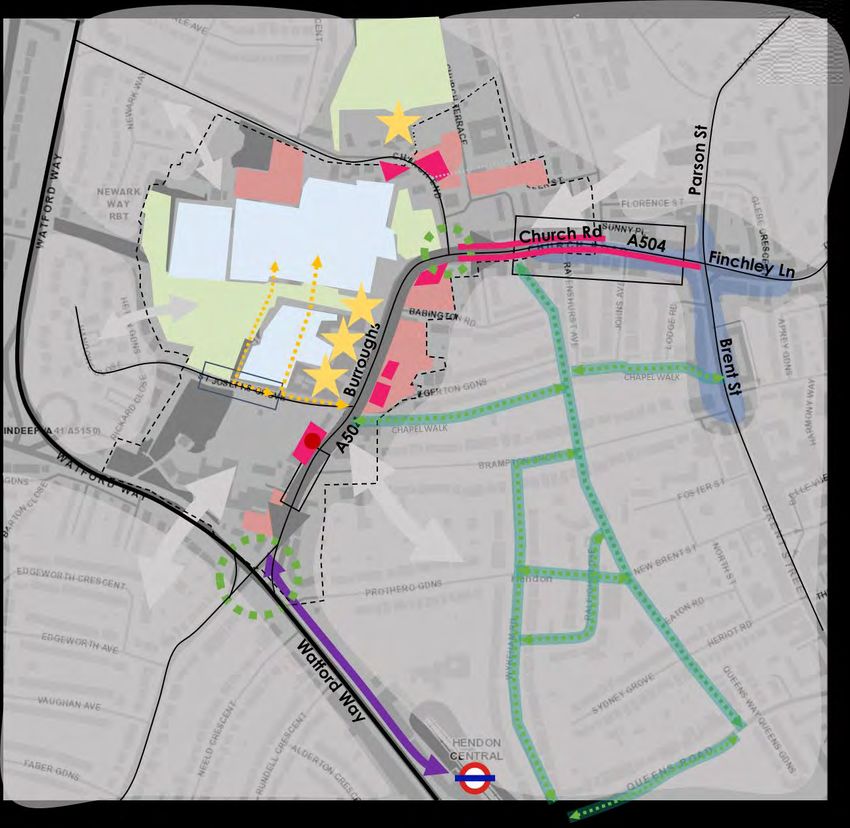
These measures/initiatives are shown schematically in Figure 6 overleaf. Figures 7, 8
and 9 present concept options at a greater level of detail.
Page 26Middlesex University and The Burroughs SPD
Transport Study
Figure 6 Schematic summary plan of SPD transport measures
Page 27Middlesex University and The Burroughs SPD
Transport Study
Figure 7 Schematic plan and descriptions of SPD ‘active travel’ measures
Page 28Middlesex University and The Burroughs SPD
Transport Study
Figure 8 Schematic plan of walking and cycling routes
Page 29Middlesex University and The Burroughs SPD
Transport Study
Figure 9 Schematic plan and descriptions of SPD ‘other’ measures
Page 30Middlesex University and The Burroughs SPD
Transport Study
These measures and initiatives are consistent with those identified, at a higher level, within the
Draft Barnet Long-term Transport Strategy (see also Figure 10):
• Low traffic neighbourhoods (to the east of The Burroughs);
• Town centre legibility (Hendon Central);
• Strengthened cycle network; and
• School streets (several locations within the SPD area).
Figure 10 Proposals for the SPD area (shaded pink)
[extracted from the 2019 Draft Barnet Long-term Transport Strategy]
Page 31Middlesex University and The Burroughs SPD
Transport Study
7 Delivery and Timescales
By taking a flexible approach to the delivery of the measures there is scope to
maximise their benefits. An indicative prioritisation of measures is shown in
Table 5 which will help ensure that each initiative is rolled out at the appropriate
time and in the most beneficial way.
On-going effort is required to evaluate and sustain the success of the SPD. This
can be achieved through setting targets and systematic monitoring against
them, including the delivery of these, and other, measures.
Theme Measure Quick win Medium-term Longer-term
Provide a direct, well-signed and high-quality pedestrian link between
Walking ✓ ✓
Hendon Central station and Middlesex University campus;
Improve pedestrian crossing provision, including at the Watford Way
Walking ✓
junction;
Improve connections between university campus and local high streets
Walking ✓
(Church Road, Brent Street)
Investigate providing dedicated cycle lanes within the SPD and
Cycling surrounding area – a mix of on-street and off-street depending on local ✓ ✓
context and opportunities;
Increase long and short-stay cycle parking provision along the corridor
Cycling – both on-street and off-street, in line with London Plan minimum ✓ ✓ ✓
standards;
Investigate new cycling connections to improve accessibility
Cycling ✓ ✓
throughout the area - eg make more use of West View;
Address actual and perceived personal security concerns – particularly
Walking and cycling ✓
along links that are poorly lit with limited natural surveillance;
Promote behaviour change based on Transport Classification of
Walking and cycling ✓ ✓
Londoners profiles (see baseline appendix); and
Actively encourage sustainable travel by students, workers, residents
Walking and cycling and visitors through a comprehensive package of ‘Travel Planning’ ✓ ✓
measures and interventions.
Reduce peak time queueing on The Burroughs through better traffic
Traffic management management - consider re-distributing demand more widely across the ✓ ✓
Hendon area, eg spreading demand via Brent Street (A502)
Introduce speed-reduction measures to stop rat-running on residential
Traffic management ✓
streets – eg local or area-wide 20mph zone
Investigate junction improvements at Church End (Greyhound Hill)
Traffic management ✓
SPECIFY?
Focussed local management on areas immediately surrounding
Traffic management ✓
schools – notably St Joseph’s Grove
Rationalise distribution and deliveries to ease congestion along Church
Deliveries and Servicing ✓ ✓
Road and southern section of The Burroughs
Carefully design new development to ensure deliveries and servicing
Deliveries and Servicing ✓ ✓
takes place off-street
Investigate relocation of bus stops O (Hendon Town Hall; northbound)
Buses ✓
and R (Church Road; southbound) to relieve localised pinch-points
Improve bus stops O and R – improved waiting facilities, countdown
Buses ✓
timers
Reduce on-street car-parking through a phased approach over time –
Parking ✓ ✓
taking opportunities to deliver public realm gains
Consolidate of existing off-street car parks – maximising utilisation
Parking ✓
throughout the day, including evenings
Increase the number of electric vehicle charging points in line with
Parking ✓ ✓
London Plan Standards
Introduce car-share clubs – with well-located spaces near to key
Parking ✓
destinations and generators of trips
Focus public realm improvements on The Burroughs corridor – reflecting
Public Realm substantial predicted increases in pedestrian footfall and activity – ✓ ✓ ✓
widened footways, improved surfacing, new seating
Create new public spaces that are inclusive and accessible and
Public Realm ✓ ✓
enjoyed by the students and local community
Improve way-finding between key local destinations, including local
Public Realm ✓
parks
Upgrade public realm – linking improvements to the phased delivery of
Public Realm ✓ ✓
new SPD developments
Table 5 Indicative prioritisation of SPD transport measures
Page 32Middlesex University and The Burroughs SPD
Transport Study
DOCUMENT CONTROL
Version Date Author Reviewer Comments
1.0 08/01/20 PB Draft content
1.1 17/01/20 PB, SA Initial draft
1.2 27/01/20 PB, SA Draft structure for review
1.3 04/02/20 PB, SA JE Draft issued to LB Barnet
2.0 27/02/20 PB, SA JE Further updates
2.1 13/03/20 PB, SA JE Final Report
2.2 07/05/20 PB, SA JE Final client review updates
2.3 12/05/20 PB, SA JE Minor update to figures
Page 33Middlesex and the Burroughs SPD Transport Study
Transport Addendum Note, October 2020
BACKGROUND:
A Stage 1 Transport study has recently been completed in line with the Burroughs SPD requirements.
The scope of the work undertaken covered the following elements:
• Provides a detailed overview of the transport and movement context in The Burroughs study
area and the wider Hendon area;
• identifies issues and potential opportunities for change to support the SPD area, focussing in
particular on The Burroughs/Church Road corridor;
• reviews the existing policy context at a borough and London scale;
• identifies overarching SPD transport objectives;
• outlines proposed SPD development opportunities;
• assesses the transport/movement implications of the proposed SPD development sites; and
• outlines a range of transport measures and interventions for the future.
The outline measures have been evaluated at a high level using a RAG (Red/Amber/Green)
assessment and are consistent with those identified, at a higher level, within the Draft Barnet Long-
term Transport Strategy. They include:
• Low traffic neighbourhoods (to the east of The Burroughs);
• Town centre legibility (Hendon Central);
• Strengthened cycle network; and
• School streets (several locations within the SPD area).
ADDENDUM SCOPE
In order to further refine the proposal and provide range of targeted measures that can be taken
forward to detailed operational assessment by the development partners a conceptual scheme
assessment of the following components is included in this Note:
The Burroughs: from the junction with Brent St to the A41 including the junctions (action 1A)
Junction of Greyhound hill / The Burroughs
All junctions and the overall route to be evaluated for compliance with TfL Healthy Streets principles.
List out potential treatments for the Burroughs that could range in order of intervention from:
a) Closure to car traffic / no through route
b) Shared surface
c) Enhanced walking and cycling facilities and crossing points with trees and street furniture
d) No change or do minimumAdditional concept study components:
A. An alternative walking route utilising the residential streets to avoid the worse air quality
and traffic noise on the A41 to be identified. This would require refinement and definition in
terms of wayfinding and local amenity impact. The identified routes could also be made
suitable for a Quietway cycling route. A review of the implications for parking would be
included as part of the assessment.
B. Investigate the potential for undertaking a joint study with TfL of the walking route leading
form Hendon station to the Burroughs via the A41.
C. Enhanced Travel planning and cycle parking in the area for students and staff.
D. A detailed scope of the parking survey work required to support the development proposal
and CPZ review has been undertaken.
The above components will be included as an addendum in the Draft SPD along with the Stage 1
Transport Report and Plans. Subject to future development quantum, trip generation and
assignment predictions the proposals will be operationally assessed by the development partners
using appropriate modelling and design tools for a detailed transport impact assessment.
This is being brought forward through the Hendon Masterplan pre-application process and a Scoping
report based on the SPD recommendations has been prepared in parallel with these investigations.1. TfL Healthy Streets Approach - Overview A street walkabout survey was undertaken along the length of the study area to assess its current characteristics relative to TfL’s Healthy Streets toolkit approach. The following elements helped inform the approach. The Healthy Streets Approach puts people and their health at the centre of decisions about how we design, manage and use public spaces. It aims to make our streets healthy, safe and welcoming for everyone. The Approach is based on 10 Indicators of a Healthy Street which focus on the experience of people using streets. There are two main indicators: • Pedestrians from all walks of life • People choose to walk, cycle and use public transport If a street is a healthy and inclusive environment then we should see all members of the community out on the street sitting, standing, walking, cycling and using public transport. There are eight other indicators that point to the essential elements required to support these two main indicators. The full list is shown in Figure 1 below: Figure 1: TfL Healthy Streets Indicators (source: TfL) The experience of being on a street affects all the human senses, which means that all the Indicators interrelate. For example if the street is very noisy, then people do not feel relaxed and they may, as a result, choose not to walk or cycle.
Assessment Framework:

The following key criteria have been used as the framework for the evaluation relative to the
PEDESTRIANS FROM ALL WALKS OF LIFE CRITERION:

    -   Does the street provide an attractive environment for walking and cycling?
    -   will people walking or cycling think the street has been designed with their needs in mind?
    -    Are public transport services frequent and direct enough to provide a competitive
        alternative to car use?
    -    Is the amount and speed of traffic and driver behaviour appropriate for the type of street?
    -    Have steps been taken to reduce the effects of motorised traffic on people walking and
        cycling, and local businesses and residents?
    -   Does the street feel looked after and is it maintained to a high standard?
    -   Is it easy for people to get to bus stops and change between different types of public
        transport? Is the street an attractive place to wait for the bus and access train stations?
    -    Is enough space allocated for walking, cycling and public transport? Will this be enough
        space for future demand?
    -   Can people cycling easily stop and secure cycles at convenient locations for accessing shops
        and services?
    -   Are people walking and cycling forced to share the same space when cycles could be
        accommodated separately?
    -   Have steps been taken to reduce the attractiveness of residential streets as short-cuts for
        motor vehicles?
    -   Have measures been taken to increase the attractiveness of residential streets as places
        where people can spend time and encourage children to play out?
    -   Can the amount, cost and availability of car parking at local amenities be changed to make
        people want to walk, cycle and use public transport over using the car?

The following key criteria have been used as the framework for the evaluation relative to the
PEOPLE CHOSE TO WALK CYCLE AND USE PUBLIC TRANSPORT CRITERION:

    -   Is the street accessible and welcoming to all?
    -   Is the street somewhere an eight or 80- year-old could happily travel independently on foot
    -   Is the local public transport offer attractive and accessible?
    -   Do the people on the street reflect all sections of society and the local community?
    -   Are any groups or individuals not using the street, particularly at certain times of the day or
        night?
    -   Is the pavement smooth, level, free of obstructions and wide enough for the number of
        people using them, now and in the future?
    -   Is it sufficiently wide to support a range of activities including scooting, skateboarding, shop
        mobility, playing, sitting and socialising?
    -   Does the mix of services along the street serve the varied needs of the local community?
    -   Could parking be removed to increase the available pavement width around obstructions
        such as trees or lamp posts?
    -   Do streets remain accessible to people walking, cycling and using public transport during
        road works and construction activity?
- Are the needs of all people who currently and potentially walk on the street being
considered in the development of proposals to change the street?
- Is additional engagement needed to ensure any concerns over accessibility are understood
and addressed?
Burroughs SPD Transport Study Interventions:
2. Urban Realm / Street Furniture Improvements: Entire Length
The urban realm along the length of the Burroughs and Church Road is of a reasonable standard
when assessed against the Healthy Street Indicators, however as a busy A Road there are a number
of considerations surrounding noise and clean air than would be difficult to target unless this was
part of an overall strategic level reduction in car use. The possibility of a full closure and
pedestrianisation has been investigated, however this is considered impractical.
The environment for walking and pedestrians is of a high standard in certain locations (e.g. in the
vicinity of the Town Hall and the University campus) but poor in others such as on the approach to
the A41 and at Church Road). Some improvements have been recently undertaken in the form of
junction entry treatments at Brampton Grove, which have led to localised benefits.
On the whole the corridor is suffering from lack of maintenance and in particular with regards to
street furniture, clutter and outdated facilities such as guard railing at crossing outside the Town
Hall.
Improvements are required in the following areas:
- Replace all broken benches with modern high-quality materials and where appropriate
provide additional locations along the length of the Burroughs where people can sit and rest
paying attention to shelter and shade.
- Review and replace any defective/broken signs
- Footways to be improved along the entire length of study area where uneven.
- Provide wayfinding signs along the corridor at appropriate intervals and outside key
buildings (Town Hall, Fire Station, University, key junctions)
- Review Bus Stop Flags and Shelters
Picture1
Broken Benches on Church Road. Street Furniture along entire length to be replaced with higher
quality materials. Uneven footways to be made good with improved materials.3. Footpath width alterations and potential carriageway realignment The existing carriageway width along The Burroughs/Church Road varies between 8-10m. A key feature of the Burroughs along most of its length but especially at the southern approach from the Town Hall to the A41 is that the footpath widths are generous on one side of the carriageway and substandard on the other. At the pinch-points footways are sub-standard (
You can also read