Victoria road, widnes - regeneration and delivery strategy August 2009 - URBED
←
→
Page content transcription
If your browser does not render page correctly, please read the page content below
victoria road, widnes
Regeneration and Delivery Strategy

August 2009
August 2009
This document was commissioned by Halton
Borough Council from URBED (Urbanism,
Environment, Design).

For information contact Halton’s Major Projects team
0151-471-7347
ian.goodall@halton.gov.uk

10 Little Lever Street, Manchester, M1 1HR
0161 200 5500
For information about URBED contact:
Jonathan Browm jb@urbed.coop
Today the street form is intact, but the area has lost much of its    It is hoped that a future role can be found to sustain investment in
In the early 20th century, Victoria Road was at the heart of life in Widnes.
                                                                           vitality as retail has shifted north.                                 Victoria Road’s urban form and economic function.

                                                                                          contents
                                                                                                                                                1. Introduction				                                4
                                                                                                                                                2. Context - Strategic			                          6
                                                                                                                                                3. Context - Local			                            10
                                                                                                                                                4. Historic Development			                         12
                                                                                                                                                5. Urban Analysis 			                              18
                                                                                                                                                6. Transport				                                   24
                                                                                                                                                7. Investment				                                  28
                                                                                                                                                8. Baseline Summary			                             30
                                                                                                                                                9. Objectives				                                  31
                                                                                                                                                10. Vision				                                     32
                                                                                                                                                Scenario 1 - Modest Capital Budget                 34
                                                                                                                                                Scenario 2 - Maximise Capital Receipt              36
                                                                                                                                                Scenario 3 - Transformational Regeneration 38
                                                                                                                                                Appraisal				                                      40
                                                                                                                                                Preferred Option				                               42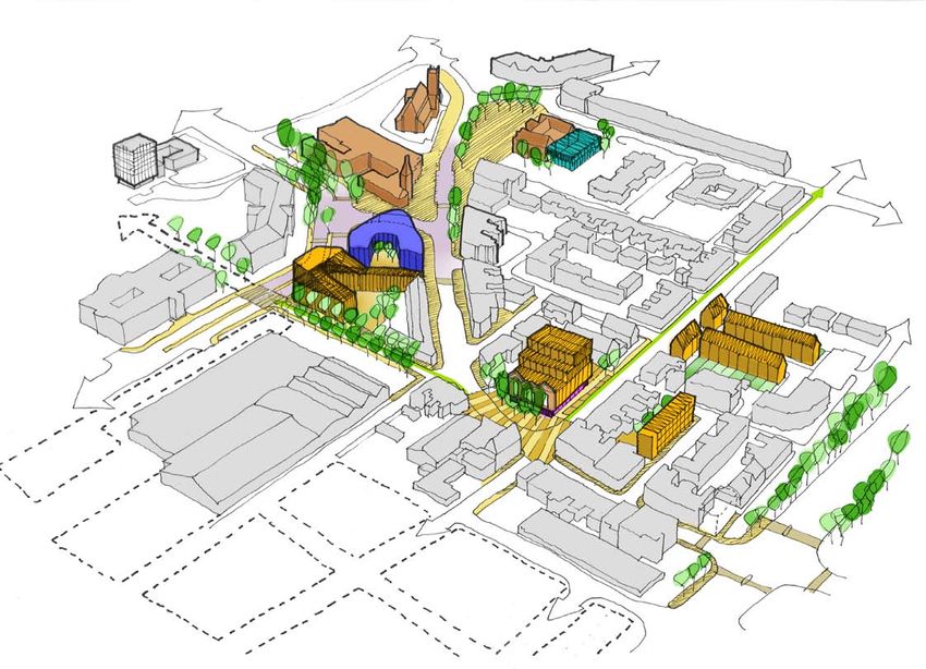
1. introduction
This study was commissioned by Halton Borough Council
(HBC) in spring 2009. Its brief is to “assess the scope to
improve and regenerate the Victoria Road area of Widnes”.

Regeneration cooperative URBED (Urbanism, Environment
and Design) have acted as lead consultants , supported by
transport planners ARUP on movement/access aspects.
Agents Keppie Massie have advised on commercial and
property issues.
                                                                                                                            WIDNES
                                                                                                                                            WIDNES
                                                                                                                                            WATERFRONT

A steering group with representatives from HBC Major Projects,
                                                                                                                             VICTORIA
Planning, Land and Property and Highways has oversen the                                                                     ROAD

study. Consultation has taken place with HBC’s conservation
officers, the managers of Moor Lane Business Centre, and                                                                                MERSEY GATEWAY

various private sector interests.

Victoria Road was once at the heart of Widnes’s civic life,
containing an array of shops and well proportioned buildings.
With the relocation of Widnes market and other functions in the
1990s, the town’s ‘centre of gravity’ has shifted north, leaving
                                                                                                                                               RUNCORN
Victoria Road increasingly tired and worn down.

Although the context still contains diverse public, private
and residential uses, environmental quality has been steadily
eroded, and there is now a need for co-ordinated help to
maximise future regeneration.

The consultant team was asked to “investigate proposals and
ideas which will lead to the improvement of the Victoria Road
area. “ The plan will be expected to contribute to the definition

                                    The area enjoys excellent strategic connections. It is situated 10 minutes drive time
                                   from both the M62 and M56, equidistant between Widnes and Runcorn mainline railway
                                    stations.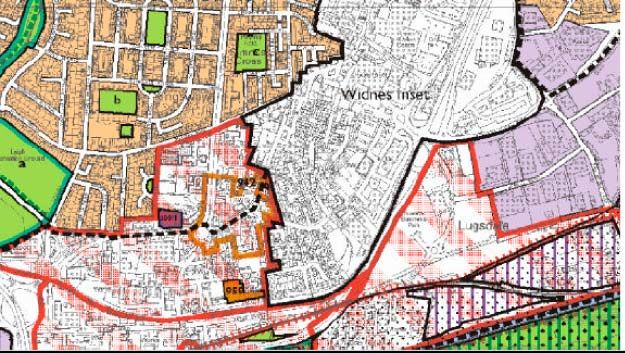
Victoria Road is in need of co-ordinated investment
of the area’s identity and sense of place.
Brief to consultants:
The aim of the commission will be to:
■ “Investigate proposals and ideas which will lead to the
improvement of the Victoria Road area. A streetscape-
led regeneration scheme which aims to enhance the
local environs and provide an improved infrastructure
along the length of Victoria Road is considered to be a
starting point for the Regeneration Plan. The Plan will
be expected to contribute to the definition of the area’s
identity and give it a sense of place.”
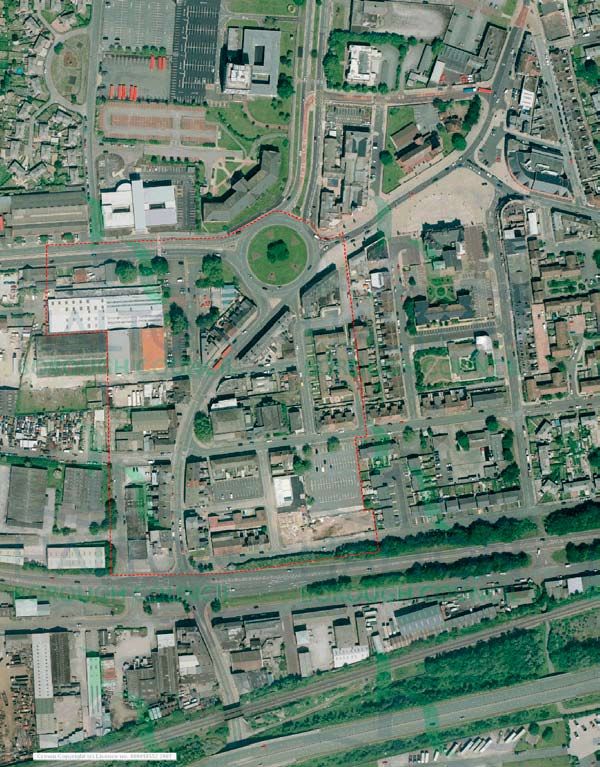
The formal study area boundary is marked in red. Its context has also been taken into
account.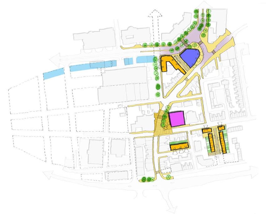
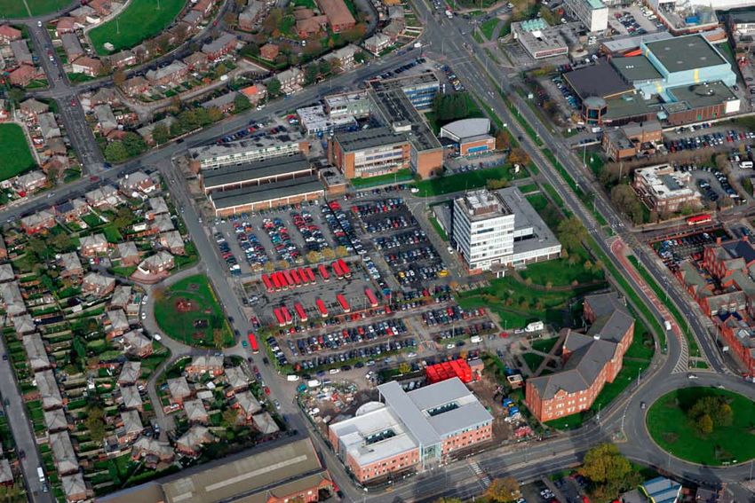
2. context - strategic
Widnes’s advantage of strong connectivity to a wide regional
catchment is undermined by the weak image presented on the
high profile routes that traverse the study area (fig 2.1).
Although itself a street of good underlying townscape quality,
in its current degraded condition Victoria Road makes little
positive contribution to the town’s image .
However, Halton Borough Council has for many years been
delivering improvements in and around the area’s context
(fig 2.3). It remains a focus for key planning and investment
policies.
2.1 Widnes offers an unfairly weak image of the town and borough alongside busy road
routes
Foremost among these strategic ambitions is the Mersey
Gateway Project for a second Halton road crossing (fig 2.2),
which would raise the area’s long range accessibility and profile
still further.
The second Halton road crossing project is accompanied by a
regeneration strategy for parts of the borough directly affected
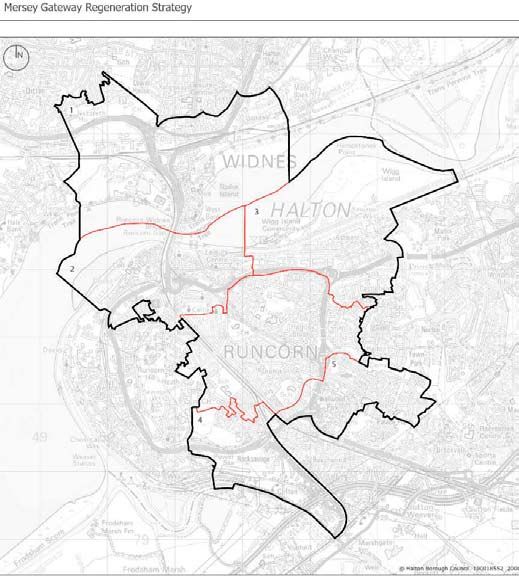
by the proposed bridge. Victoria Road is included within the
‘West Bank Area of Influence’ (fig 2.4) in the Mersey Gateway
Strategy.
2.2 The proposed Mersey Gateway will boost the profile and economy of the Borough.
2.3 Numerous improvements are taking place in and around the area.

Strategic Context

Key policies include:

■   Mersey Gateway Project and accompanying Strategy
    - Victoria Road is in the West Bank ‘Area of Influence’.
■   UDP Action Areas - Victoria Road is covered within
    regeneration policy RG2, Central Widnes. This is one of
    six area based regeneration priorities in Halton.

                                                                      2.4 Mersey Gateway Strategy - Areas of
                                                                      Influence
2. context - strategic
Central Widnes
Action Area
In Halton Borough Council’s Revised Unitary Development Plan
(Policy RG2)
(UDP), Victoria Road forms part of the Central Widnes Action
Area, one of six area-based regeneration priorities identified in
the Borough (fig 2.5).
Regeneration policy RG2 applies to the Action Area. It sets
out a mix of uses, including higher density residential, to build
on the ongoing civic role around the Courts, Council offices,
College, Library and Leisure Centre.
Victoria Road is identified as a secondary shopping area, where
small retail, evening economy and other uses are acceptable
provided they support rather than undermine the town’s
primary retail core. The policy also advocates good design and
restricts environmentally blighting uses.
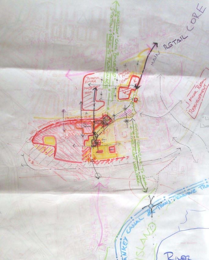
Two other Action Areas lie immediately adjacent, ‘Southern
Widnes and Widnes Waterfront . A Supplementary Planning
Document (SPD) for Southern Widnes has been prepared (fig
2.7), as has a masterplan for Widnes Waterfront, where office
uses are to be concentrated.
The SPD for Southern Widnes expects future development
to tackle the physical and functional severance of the West
Bank area from the town centre, and seeks to establish well
connected active streets.
In this context, Victoria Road has an important strategic role 2.5 Halton Borough Council has designated six ‘Action Areas’ in its UDP. Victoria Road forms part of
as a linkage and gateway between West Bank and the rest of the Central Widnes Action Area, addressed under Regeneration Policy RG2.
Widnes. 1. Southern Widnes; 2. Central Widnes; 3. Widnes Waterfront; 4. Runcorn and Weston Docklands; 5.
Halebank; 6. Castlefield and Norton Priory
2.6 Halton’s Revised Unitary Development Plan (UDP) Proposals Map shows Victoria Road
‘washed over’ by the Regeneration Action Area Policy RG2 (shown by the diagonal red hatchings).

The Victoria Square conservation boundary is shown, protected by Built Environment Policies BE
13, 14 - 16 (the area outlined in orange).

Moor Lane and the route into Victoria Square are shown as environmental priority areas (the
dashed black line).

Two site allocations are shown nearby, both now built out with a Health Centre and residential
development.

To the south of Ashley Way a potential railway station is shown, should the freight line be returned
to passenger use.

2.7 The Draft Southern Widnes Supplementary Planning Document (SPD) provides a long term
planning framework for the area around the proposed new bridge infrastructure.

There is limited direct impact on Victoria Road, but the SPD is important policy context, as
Victoria Road provides the key linkage from West Bank to the rest of the town.

The stretch of Victoria Road at the southern end of the study area across Ashley Way and under
the new bridge approach is shown as a ‘focus for public realm improvements’ (bounded by a
dotted red line).

The Kingsway Roundabout is acknowledged as a ‘key node’ surrounded by landmark buildings.

A new local centre for West Bank is proposed near the Catalyst Museum and Spike Island
(marked on the plan by a blue circle).
3. context -                                                       local
Victoria Road is a key part of Widnes’s historic spine. It           Footfall and Activity Generators:
connects the communities above the Victoria Promenade at
                                                                     - Riverside College - 500 staff and 2,000
West Bank, where the old ferry and Transporter Bridge used
                                                                       students
to cross the Mersey, through the civic quarter to Albert Road,       - Pool and leisure centre - 92 staff and
                                                                       320,000 visitors per annum
Widnes’s main retail focus.
                                                                     - Library - 26 staff and 216,000 visitors
                                                                       per annum
The civic quarter is adjacent to the study area. Part of it, the     - Council office - 300 staff
                                                                     - Kids Planet Nursery (Kingsway Centre)
Victoria Square conservation area, is the finest architectural         26 staff, 80 places and 250 parents
ensemble in the town; its red-brick character and civic scale          visiting per day
                                                                     - Kingsway Learning Centre - 200 staff
extend along Victoria Road. The civic area comprises Halton’s        - Police Station - 180
major cluster of public assets and employers, loosely arranged       - Halton Transport Bus Station - 140 staff
                                                                     - Fire Station - 70 staff and 200 visitors
in a ‘campus’. They generate and attract large amounts of              per annum
activity and footfall, but could be better integrated with each      - Moor Lane Business Centre - 41
                                                                       businesses
other, the study area and wider town.
                                                                     Totals - 1534 known staff
                                                                            - 3700 known daily visitors on
Having been ‘double-by-passed’ by the A562 and A568, the
                                                                              average
spine is now mostly defunct as a primary traffic route. Indeed,
further north, it has for many years been fully pedestrianised at    These may well underplay the true
                                                                     numbers. They do not include:
Albert Road, and is also blocked to traffic at the ASDA site.

                                                                     - HBC Children’s Centre - Not known
The Victoria Road spine still has an important public transport      - NHS Health Centre - Not known
role as a route from West Bank to the town centre, but through       - DWP/Job Centre - Not known
                                                                     - Kingsway Hotel - Not known
traffic can avoid the study area altogether by accessing Green       - Post sorting office - Not known
Oaks via Ashley Way and Watkinson Way.                               - Ambulance station - Not known

                                                                     - Buzz Youth Centre - Opening 2010
The configuration of parking and highways infrastructure in          - Studio - Opening 2010
the study area has not changed to reflect Victoria Road’s
                                                                     - Courts - Closed 2009
importance as a local rather than strategic traffic link. At
present highways are set up for high traffic flows, with
extensive parking restrictions to protect access to the
former market. This format is now obsolete and the public
                                                                                                  2.8 There are numerous important uses within a short walk of Victoria Road. These generate large
environment needs to be re-balanced towards the needs of                                          volumes of movement and footfall, a potential source of trade and activity for the study area.
local businesses, residents, public transport users, pedestrians
10
and cyclists.
The socio-economic context of the study area is an important
consideration. The 2007 Index of Multiple Deprivation shows
the Kingsway Ward as within the 5% most deprived nationally
(fig 2.8). In the domain of income , the southern part of the
ward is within the 1% most deprived. For health the ward is
also in the worst 5%.
The ‘Community Strategy for a Sustainable Halton 2006 - 11’
sets out the Local Strategic Partnership’s aims. We have
picked out two with particular relevance to Victoria Road in the
light of its small business sector and potentially memorable
streetscape character.
“We want to see a strong business sector, to create new
enterprises and new jobs to benefit local people.”
“We need to retain a clear sense of place and retain features
that make Halton distinctive.”
2.8 (Above) Whilst Halton has seen significant improvements
Another key policy document is ‘Halton: Gateway to in terms of quality of life over recent years, the 2007 Indices of
Multiple Deprivation (IMD) indicates that Halton remains one of the
Prosperity’, the Borough’s ‘Economic and Tourism most deprived Boroughs in the country.
Development Strategy’. This document looks at ways to
The above plan from the Mersey Gateway Regeneration Strategy
diversify and add value to the town’s economy. Each of its four
shows significant spatial concentrations of deprivation.
key aims is relevant to the study area:
Kingsway Ward in southern Widnes (which includes the study area)
is ranked within the 5% most deprived nationally.
1. Enterprise and Performance - “Fostering the development of
enterprise culture and improving the performance of business”. On the ‘income’ domain the southern part of the ward is within the
1% most deprived in the country.
2. Employment and Skills - “Increasing levels of employment
2.9 and 2.10 (Above right and right). The social and economic
and improving workforce skills to meet business need”. ambitions of the Borough are set out in these two key documents.
3. Property and Infrastructure - “Consistently improving
infrastructure and enabling investment in land and property to
create a supply of quality premises.”
4. Environment and Image - “Improving the quality of the
11
environment and the image of Halton.”4. HISTORIC Complete by c. 1880 (see fig 3.9)
Police Station
DEVELOPMENT
The Doctors Pub
St. John’s Market
Volunteer (‘Drill’) Hall
Original Widnes Station
Victoria Road’s provenance as a highway probably goes
Wesleyan Chapel (Queen’s Hall)
back centuries, given the existence of a ferry service Street blocks of Lacey St, Croft St
across the ‘Runcorn Gap’ since the 1100s. There has etc.
been a permanent settlement on the higher ground above Complete by 1891
the marshy riverbanks for a similar period, with Appleton
Town Hall (incl. first Library)
mentioned in the 1086 Domesday book, and the church at St. Paul’s Church
Farnworth dating from around 1180. Victoria Road is likely Alexandra Theatre
Original Central Station
the old route between the ferry and Farnworth and Appleton Hotel on the corner of Market St.
villages. Queen’s Arms Hotel
Completed later (see fig 3.10)
Urbanisation took off when the very early industrial railway
Library and Technical School
between St. Helen’s and the Runcorn Gap opened in 1830,
Market Extension
the same year as George Stephenson’s more famous Conservative Club
Police Station demolished for
Liverpool to Manchester line. To compete with the train an
Kingsway Roundabout
extension to the Sankey Canal was opened in 1833, and, Lacey Street and Ollier Street
3.1 View south west along Victoria Road a century ago - note the Police Station and the industrial setting.
with the building of Widnes Dock, the area now known as
3.2 Victoria Road circa 1849, just before its rapid urbanisation.
Spike Island became world’s first interchange complex
between a canal, a railway and a dock. The junction with Moor Lane and the street’s distinctive curve are
clearly visible.
Cheshire salt was carried down the Weaver from Northwich
on ‘Mersey Flats’ and off loaded for St. Helens glass-
3.3 The Alexandra
makers in return for Lancashire coal. Chemical industries Theatre just off Victoria
were attracted to Widnes by coal and salt, but also because Road on Alexandra
Street was the only
trustees of Runcorn’s Bridgewater Canal refused sale or purpose built playhouse
lease of their land to such noxious polluters. Financially ever in Widnes. It
opened in 1887 and
if not environmentally one riverbank’s loss was the others burned down in 1949.
gain, and the second half of the 19th century saw Widnes
In its life it hosted stage
develop into a burgeoning industrial town.
luminaries including a
young Charlie Chaplin
and Stan Laurel.
Victoria Road become the expression of a new municipal
identity, containing the town’s best buildings and traders.
123.7 This ’figure ground’
plan shows the area’s
pattern of buildings
and spaces as it was
in 1938.
The urban grain was
quite ‘tight’ aong
Victoria Road, but
much land either side
of the spine remained
undeveloped.
3.4 Inter-war aerial view showing the new Kingsway to the left.
1938
3.8 This ‘figure ground’
from 2009 shows how
Victoria Road’s pattern
has survived as the
empty sites to the west,
north and east have
been developed.
3.5 The Queen’s Hall was originally a 19th century Wesleyan Chapel
Development in the
second half of the 20th
century has been quite
piecemeal and only
loosely structured, as
shown by the varying
building footprints and
configuration.
13
3.6 Victoria Road a century ago, looking towards the Conservative 2009
Club.1879
14
3.8 (above) Plan of the Victoria Road area circa. 1879 3.9 (right) Plan of the Victoria Road area fifty years later, in
19391939
155. urban analysis
Victoria Road remains a fundamentally well defined street. It has a consistent building and
roof line emphasising its continuous curve, giving a modest ‘crescent’ effect.
The street itself has a complex mix of uses, some inactive during the day, but with the
majority of ground and upper floor frontages offering at least a degree of animation and
overlooking.
Either side of Victoria Road the built form breaks down, especially to the west, which is an
industrial area of sheds and yards.
As can be seen from figures
5.1 and 5.2, whilst the built
form of the original civic
street is still intact, the 5.3 Building Use
sense of quality and pride
Land Use:
has eroded.
Victoria Road is now home to a mix of shops and Legend
businesses associated with its designation as a ‘secondary’
This is largely a matter of A1 Retail
retail street.
detail and upkeep, with the A2 Financial & Professional Services
decline being especially A3 Cafes/Restaurants/Food&Drink
These include power tool sales, a bank and a motorcycle
marked in the public realm. 5.1 and 5.2, Victoria Road ‘then and now’ showing a decline in quality. A4 Public House or Club
showroom. Specialist businesses including a piano
A5 Takeaway/Fast Food
showroom, commercial art gallery and fishing shop add
High quality brick and B1 Business
further interest and diversity.
stone materials have been B2 General Industry
obscured by cheaper B8 Storage & Distribution
There are a number of uses associated with the evening
renders and tarmac. Street C1 Hotels
economy, including hot-food takeaways, pubs, nightclubs
furniture is more cluttered. C3 Residential
and taxi-firms. These often detract from day-time vitality.
Shopfronts and signage D1 Non residential Institutions
The empty Queen’s Hall theatre is a major ‘hole’ in this use
are of less coherent design D2 Assembly & Leisure
pattern.
than in the past. Pedestrian Sui Generis
space has been given over Unknown
The Moor Lane area west of Victoria Road is dominated
to traffic infrastructure.
by light industrial and warehousing uses, including a scrap
16 metal yard, whereas the east is residential.Frontages:
The blue lines on the plan to the right show the high extent of ground floor frontages that
offer some kind of ‘active’ interface with the street during the day-time.
This includes the key entrance points of all buildings open to the public during normal
trading hours, and also the fronts of private dwelling houses, which collectively generate a
sense of activity and thus ‘natural surveillance’ throughout the day.
The orange-brown lines show frontages that do not offer an active edge to the public realm
during the day. This may be because they have a blank elevation, are empty properties or
are only open to the public after hours.
There is a ‘dead area’ in the heart of the street around the Queen’s Hall and the
Conservative Club, which detracts from vibrancy and therefore wider vitality.
Inactive frontages dominate the industrial area west of Victoria Road.
Active Frontage - Good surveillence
Inactive Frontage - Poor surveillence 5.4 Active Frontage
5.5 Building Height
Building Heights:
The predominant building height along Victoria Road is of 2/3 ‘habitable storeys’ plus roof
s space.
This harmonises the relation of height to street-width to create a good sense of enclosure.
Distinctive red-brick towers on the library and church to the north-east create well framed
visual landmarks when moving from the south of Victoria Road.
Either side of Victoria Road the height drops . To the east the Victorian terraced houses
create a consistent roof line of two habitable storeys plus roof space. Commercial premises
to the west are a mix of single and double height buildings.
4 and over storeys
3
2
1 storeyPotential Townscape Contribution:
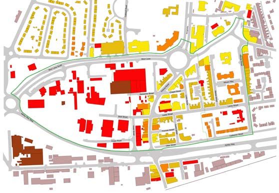
Figure 5.6 shows a plan ranking each building’s potential contribution to overall
townscape quality. It attempts to capture each building’s relative urban design and
architectural value without regard to current condition.
So the well proportioned and detailed run of buildings on the south side of the
roundabout are shown as fundamentally very good townscape elements, ignoring for the
moment crude alterations like shutters and signage (these are picked up in the condition
plan, figure 5.8).
Victoria Road and the north and east parts of its setting still posesses a Legend
number of distinctive buildings that build a potentially strong townscape
Very Good
character.
Good
Fair
Even modest shops and terraced houses are fundamentally strong in the
Poor
basic principles of urban form - building line, massing, rhythm and so on.
Very Poor
5.6 Townscape Contribution
Victoria Road’s weakness in terms of potential townscape contribution is
to the west side, where the townscape contribution of most buildings is
poor. 5.7 Strong and Weak
‘Zones’ of strong and weak townscape
Figure 5.7 simply illustrates the above more schematically.
It combines buildings ranked potentially good or above into one zone, ‘areas of strong
townscape’, which can be seen to run for most of Victoria Road north from Ashley Way.
Similarly it combines any building deemed not to have a potentially strong townscape
contribution, i.e. those ranked only ‘fair’ or below in fig 5.6, into an area of weak
townscape., which wraps around much of the core study area, encroaching into Victoria
Road at the south western end.
Areas of Strong Townscape
18
Areas of Weak TownscapeBuilding Condition:
Figure 5.8 is based on a brief assessment of visual condition of frontages from the road.
It is not a survey of structural integrity but of the impression given by existing materials
and building management, especially at ground floor level. Thus a shabby or bricked up
shop-front scores poorly, even on a building in fair overall repair.
Victoria Road suffers as a whole from poor building condition with few parts acheiving a
rating higher than fair. In particular the south west end of Victoria Road is in a tired state.
Some buildings here exhibit external ‘ties’ associated with structural settlement.
Conditions around the Queen’s Hall are a particular concern. In its
current state the empty and semi-derelict building is a blight.
Very Good
In general, condition is better nearer to the town centre. It may be Good
that recent investments in the Library, former Town Hall etc. have Fair
underpinned confidence here. Poor
Very Poor
5.8 Visual
Some fine buildings like the former Storey’s nightclub are marred by
crude additions and alterations.
5.9 Hard and
‘Hard and Soft’:
Figure 5.9 is an assessment agreed between the council and consultant team as to
where this study could consider future alterations to the built form (known as ‘soft’ areas,
shown in light pink) and where is likely to remain fixed (the ‘hard areas’, shown in purple).
Hard - Keep and Maintain
Soft - Redevelopmain victoria road frontage b
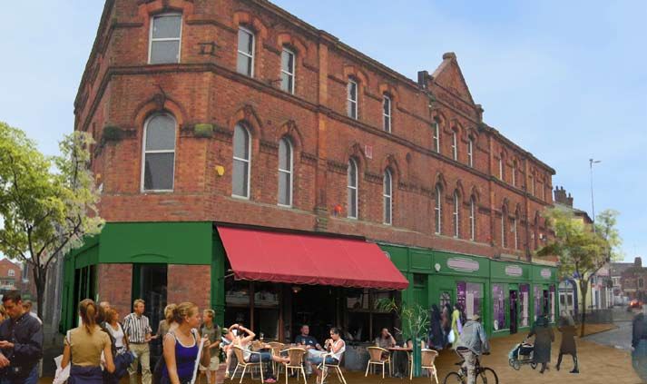
5.10 Former Storey’s Nightclub 5.11 Shop fronts on the east side of Victoria Road 5.12 The Queen’s Hall, no longer in use
The massing and detailing of Victoria Road’s frontages A variety of enterprises operate in the area. The council The Queen’s Hall is a converted Wesleyan Chapel, for
is well handled, giving a strong sense of continuity and have been targetting small grants to improve signage and many years famous as the town’s main theatre and public
enclosure to the street form. These qualities are let down shop fronts; more such treatments may be needed to hall. Replaced by the high quality Brindley centre in
by some crude contemporary alterations. support the business environment along the corridor. Runcorn, an alternative use has yet to be found.
5.13 Victoria Road at the south end of the study area 5.14 Conservative Club and former Drill Hall 5.15 Victoria Road looking south from the Alexandra Street
junction
The pedestrian environment is tired, and short stay Victoria Road retains some ‘local landmark’ character The historic building line, which remains intact, is stepped
parking restricted by double yellow lines. Shop frontages buildings that hint at its former status at the heart of civic back from the street in places. This gives the effect of
are inconsistent and sometimes bricked up. The highway life. Some are still in use while others have fallen empty. a sequence of incidental spaces, with the area in front
is configured as a main road. All of these factors restrict All would benefit from facelifting and more sensitive of the Queen’s Hall and Conservative Club having the
businesses’ ability to capture passing trade. treatment of signage and their public realm setting. potential to form a sort of ‘square’, if traffic impacts can
be reduced.bold street and lacey street area
5.16 Bold Street, with the rear elevation of Victoria 5.17 The gateway to Victoria Road from Ashley Way 5.17 Catherine Street
Road
Immediately behind the main road frontage environmental The interface of Victoria Road as a gateway to the town Taken from the same position as the previous picture
quality tends to fall away drastically, into a patchwork centre was given little thought when Ashley Way was looking to the east, the ‘placeless’ nature of the Ashley
of gap sites, informal parking and ad-hoc development constructed. This blank gable end gives no sense of the Way interface is further emphasised. A higher quality
forms. However, many businesses are housed and local traders or heritage buildings to be found along the landscape buffer, such as that along Speke Boulevard in
supported here. town centre spine. Liverpool, may be possible here.
5.18 ‘The Studio’ and Spiritualist Chapel on Lacey 5.19 Conservative Club and former Drill Hall 5.20 New build apartments on Guest Street
Street
The area off Victoria Road still has some character Ashley Way cuts through Victoria Road along the route of New apartment developments have sprung up around
buildings including these old chapels, as well as some the old Central Railway. The pedestrian environment at Lacey Street in recent years. Their massing and building
robust small terraced houses. Happily, Loose Music the crossing is a major severance point between the town line respects the established grid pattern. However, their
Collective secured £602k funding to restore the Studio in centre and West Bank, which contains key attractions design and the public realm treatment adjacent add little
March 2009. in Spike Island, the Catalyst Museum and Victoria to local distinctiveness.
Promenade.adjacent conservation area - victoria square
The beautifully restored Technical School and Library complex Elaborate architectural and window detailing ‘The View’ bar in the converted Co-Operative Building
Halton council have recaptured the spirit of public The high standards of craft and artistry shown in the Heritage buildings are often robustly contructed, with
‘improvement’ promoted by the town’s forefathers in their town’s finest buildings are now widely appreciated, built in flexibility that allows their conversion to new uses.
splendid restoration of the listed library and Technical and can inspire a contemporary response in investors, The Co Op building in Victoria Square is now part of the
School as a 21st century Learning Centre. designers and prospective end users. town’s evening economy, although its daytime vitality is
limited.
Apartment conversion of former public house/hotel on Alforde St The old Town Hall, built 1885, is being converted to a hotel A combination of conversion and new build on Market Street.
Above is another conversion of an historic building, The old Widnes Town Hall is a magnificent centre-piece to A high density apartment development in new and
protecting townscape quality and bringing new the square, but has been under-used for many years. Its converted buildings. Residential uses occupy upper
investment into the town centre (although the impact is proposed conversion to a ‘Boutique Hotel’ will bring fresh floors above some of the buildings along Victoria Road,
lessended by white UVPC frames). However, the public life. The square itself lacks activity, enclosure or shelter, though not in this ‘aspirational’ apartment format.
realm still lacks animation and is not enhanced by street and needs further thought.
furniture items like standard railings.adjacent Kingsway CIVIC Area
Halton Borough Council’s main offices on Kingsway The new NHS health centre on Moor Lane is well designed The former Kingsway Health Centre as it appeared while in use
Several hundred staff are housed in Halton Borough The Health Care Resource centre is another focus for The art-deco Health Centre, built by the council in 1939, is
council’s main offices on Kingsway. Partner agencies also activity, with a high concentration of medical staff and a distinctive example of a pre-NHS public health building.
access the building to liaise with various council services. service users. Again, it is an attraction that offers It is now vacant, but the subject of exciting plans for
There is therefore quite a focus for activity on the building, potential trade and vitality to Victoria Road, but the dual conversion to a dedicated youth facility. This could
a potential benefit to Victoria Road. carriageway on Moor Lane and the weak sense of activity complement ‘the Studio’ performance venue proposed in
along Witt Road limit interaction.
The ‘Kingsway Campus’ of Riverside College of F.E. The Magistrates Court and Police Station Kingsway Leisure Centre and Halton’s Stobart Stadium.
Riverside is Halton’s College of Further Education, with
The well-used Leisure Centre contains a swimming pool
campus facilities at Runcorn, Kingsway and Cronton. Another focus for activity a short walk from Victoria Road
and large sports hall with various other sporting and
It provides education for several thousand students, is the town’s Magistrates Court and Police Station. The
spectator facilities. The Stadium has a capacity of over
including night-classes, and employs several hundred courts are housed in a particularly elegant 1960s ‘pavilion’
13,000 and is used for conferencing as well as being
staff. It is a great generator of footfall and activity just a building 9though its condition is tired).
home to Widnes Vikings Rugby League team and Everton
short walk away.
F.C. reserve games.6. transport
ARUP associates’ review of movement and access issues
is set out in a separate Appendix to this report. Overall
they find the study area has adequate but not outstanding
provision for public transport users, pedestrians and
motorists.
However, they note that parking and highway infrastructure
within the area is the legacy of a previous era, engineered
for traffic flows and parking patterns that have changed
substantially. This limits comfortable access to businesses
and facilities. Lack of convenient on-street parking deters
capture of passing trade, and pedestrian severance limits
footfall between the area and major civic uses nearby.
The main spine is fundamentally pedestrian friendly,
with wide footways in places. The provision of crossing
facilities is adequate but could be improved to encourage
more footfall. Weak spots for pedestrians are the Ashley
Way crossings and the high traffic speeds encouraged
by the roundabout. Moor lane is a barrier to comfortable
movement from the civic and residential areas.
Cycling facilities could be significantly improved. There
is a lack of coherent interconnected routes, limited cycle
facilities on the ground and a lack of signage or dedicated
6.1 Highway Network
parking.
Key to 6.5 Parking
Highway Network Key to 6.2 Pedestrian Facilities Key to 6.3 Cycling Key to 6.4 Public Transport
Taxis Only
Primary Highway Pedestrian Attractions Traffic Free Route Bus Stop
No Waiting At Any Time
Secondary Highway Pedestrian Barriers Shared Use - Foot/Cycle Taxi Bays
No Waiting (Mon-Sat 8am-6pm)
Local Highway Network Pedestrian Crossing Cycle Route (On road) Public Transport Routes
Limited Waiting (Mon-Sat 8am-7pm 20mins No Return 40mins)
Victoria Road Pedestrian Routes Pedestrian Crossing
Limited Waiting (Mon-Sat 8am-6pm 40mins No Return 1hr)
24 Limited Waiting (Mon-Sat 8am-6pm 2hrs No Reutrn 1hr)
Public Car Park
6.2 Pedestrian Routes & 6.3 Cycling
6.5 Parking
6.4 Public
25
You can also read