AMATHOLE DISTRICT MUNICIPALITY - WETLAND REPORT | 2017 LOCAL ACTION FOR BIODIVERSITY (LAB): ICLEI AFRICA
←
→
Page content transcription
If your browser does not render page correctly, please read the page content below
Amathole District Municipality
   WETLAND REPORT | 2017

 LOCAL ACTION FOR BIODIVERSITY (LAB):
       WETLANDS SOUTH AFRICA

                     Biodiversity for Life
                     South African National Biodiversity Institute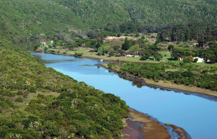
Full Program Title:   Local Action for Biodiversity: Wetland Management
                                           in a Changing Climate
               Sponsoring USAID Office:    USAID/Southern Africa
      Cooperative Agreement Number:        AID-674-A-14-00014
                            Contractor:    ICLEI – Local Governments for Sustainability – Africa Secretariat
                    Date of Publication:   June 2017

DISCLAIMER: The author’s views expressed in this publication do not necessarily reflect the views of the
United States Agency for International Development or the United States Government.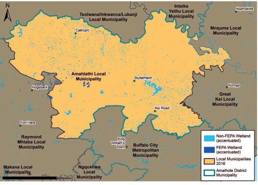
Foreword

Amathole District Municipality is situated within the    Amathole District Municipality is also prone to climate
central part of the Eastern Cape Province, which lies    change and disaster risk such as wild fires, drought
in the southeast of South Africa and borders the         and floods. Wetland systems however can be viewed
Indian Ocean. Amathole District Municipality has         as risk reduction ecological infrastructure. Wetlands
a land area of 21 595 km² with approximately 200         also form part of the Amathole Mountain Biosphere
km of coastline stretching along the Sunshine Coast      Reserve, which is viewed as a conservation and
from the Fish River to just south of Hole in the Wall    sustainable development flagship initiative.
along the Wild Coast. Amathole District Municipality
coastline spans two bio-geographical regions, namely     Amathole      District      Municipality   Integrated
the warm temperate south coast and the sub-tropical      Development Plan (IDP) recognises the importance
east coast.                                              of wetlands within the critical biodiversity areas
                                                         of the Spatial Development Framework (SDF).
Amathole District Municipality is generally in a good    Sustainable development principles are an
natural state; 83.3% of land comprises of natural        integral part of Amathole District Municipality’s
areas, whilst only 16.7% are areas where no natural      developmental approach as they are captured in the
habitat remains. The biodiversity of the Amathole        vision: “Commitment towards selfless, excellent and
District Municipality is represented in 5 major biomes   sustainable service to all our communities”.
that describe the different biotic communities. These
biomes are Savanna (34.5%), Grasslands (31.5%),
Albany Thicket (29.6% of the area), Indian Ocean
Coastal Belt (3.7%) and Forests (0.7%).

Amathole District Municipality is a water service                 Cllr. N. W. Nxawe
authority and provider. As such, two major catchment               Executive Mayor
areas, i.e., Amathole Catchment (north) and Great                 Amathole District
Fish River Catchment (west), provide essential water                    Municipality
resources. More than 70% of wetlands are located
within these catchment areas. Amathole District
Municipality views wetlands as an essential resource
for the fulfilment of its constitutional mandate of
providing sustainable basic services to communities.

                                         Amathole District Municipality: WETLAND REPORT              I 2017    1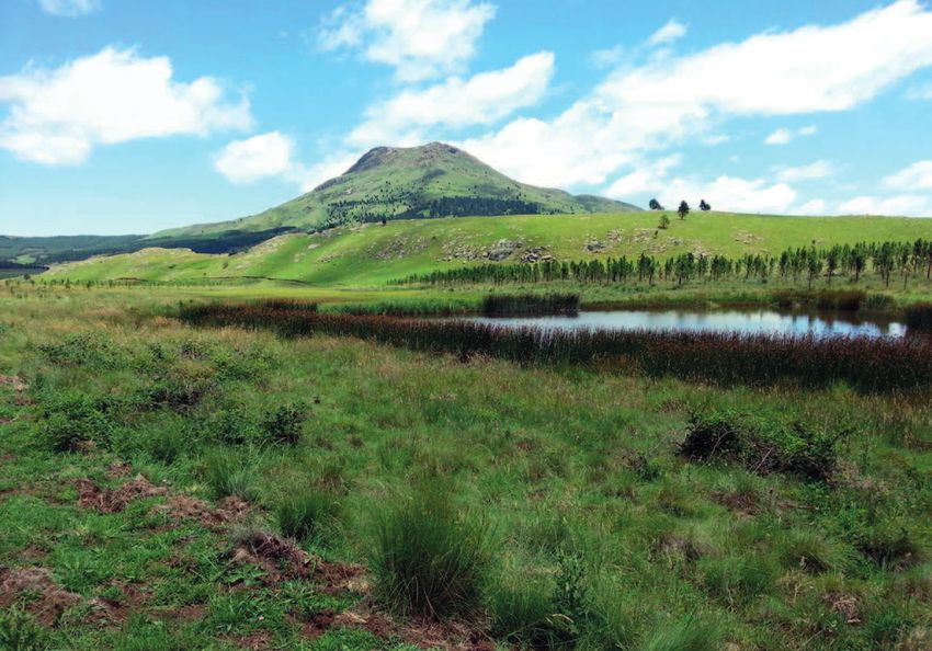
ICLEI – LOCAL GOVERNMENTS FOR
SUSTAINABILITY

    ICLEI-Africa@iclei.org      +27 21 202 0381           www.africa.iclei.org     www.twitter.com/ICLEIAfrica

ICLEI – Local Governments for Sustainability is the         In order to strengthen the role cities and local
leading global network of over 1,500 cities, towns and      governments play in the pursuit of greater
regions committed to building a sustainable future.         sustainability through the collaborative design and
By helping the ICLEI Network to become sustainable,         implementation of integrated urban development
low-carbon, ecomobile, resilient, biodiverse, resource-     and effective biodiversity management, the ICLEI
efficient, healthy and happy, with a green economy          Cities Biodiversity Center (ICLEI CBC) was created in
and smart infrastructure, we impact over 25% of the         2009. The ICLEI CBC is located in Cape Town, South
global urban population.                                    Africa, embedded in the Africa Regional Office of
                                                            ICLEI. We offer cities a broad portfolio of supportive
ICLEI Africa’s work is conducted by a dynamic and           services through our dedicated team of passionate,
passionate team of professionals that seek to work          skilled and dynamic biodiversity and urban
with cities to ensure a more sustainable future, with a     development experts.
specific focus on urban biodiversity matters.

2   2017   I Amathole District Municipality: WETLAND REPORT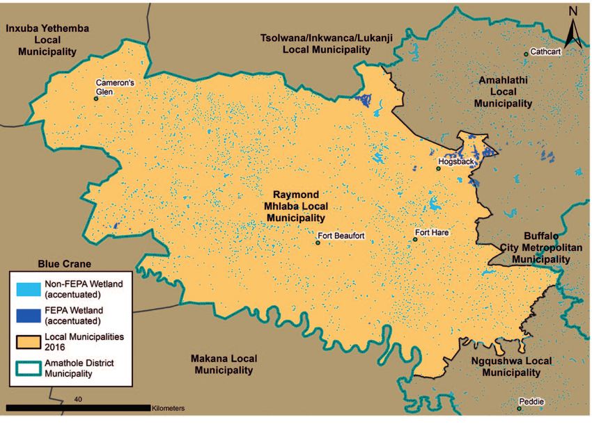
ICLEI CITIES BIODIVERSITY CENTER
LOCAL ACTION FOR BIODIVERSITY PROGRAMME

    ICLEI-Africa@iclei.org      +27 21 202 0381           www.africa.iclei.org     www.twitter.com/ICLEIAfrica

The ICLEI Cities Biodiversity Center aims to create         buffers further biodiversity loss, improves the urban
BiodiverCities, which promote urban biodiversity for        standard of living, and provides local opportunities
the many benefits they offer, including human well-         for global education and awareness.
being, poverty alleviation, habitat conservation, air
and water quality, climate change adaptation and            ICLEI’s Local Action for Biodiversity (LAB) programme
mitigation, food provision, fortified infrastructure        is a unique global biodiversity programme run by
resilience, and happiness of citizens.                      The ICLEI Cities Biodiversity Center. The LAB Program
                                                            is aimed at improving and enhancing ecosystem
BiodiverCities are aware that ecosystem services            management at the local level, and is recognized
contribute towards many essential municipal                 globally as the leading results-driven local government
services, as well as towards the local economy,             biodiversity initiative. Currently, LAB is working on
sustainability and social well-being of their cities.       wetland restoration in South Africa under the Local
Biodiversity in cities provides a critical contribution     Action for Biodiversity: Wetlands South Africa (LAB
towards achieving the global biodiversity targets. It       Wetlands SA) project.

                                          Amathole District Municipality: WETLAND REPORT                I 2017    3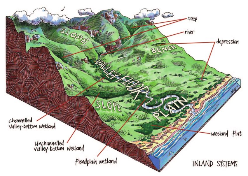
table of contents

Foreword�����������������������������������������������������������������������������������������������������������������������������������������������������������������������������������������������������������1
ICLEI – Local Governments for Sustainability��������������������������������������������������������������������������������������������������������������������������������������2
ICLEI Cities Biodiversity Center�����������������������������������������������������������������������������������������������������������������������������������������������������������������3
Local Action for Biodiversity Programme���������������������������������������������������������������������������������������������������������������������������������������������3
List of Acronyms and Abbreviations�������������������������������������������������������������������������������������������������������������������������������������������������������6
List of Tables����������������������������������������������������������������������������������������������������������������������������������������������������������������������������������������������������6
List of Figures��������������������������������������������������������������������������������������������������������������������������������������������������������������������������������������������������7
Executive Summary���������������������������������������������������������������������������������������������������������������������������������������������������������������������������������������8
Introduction�����������������������������������������������������������������������������������������������������������������������������������������������������������������������������������������������������9
Scope and Purpose of the Report����������������������������������������������������������������������������������������������������������������������������������������������������������10

1 i What is a Wetland?���������������������������������������������������������������������������������������������������������������������������������������� 11

2 | What is Biodiversity?����������������������������������������������������������������������������������������������������������������������������������� 13

3 | Wetlands and Biodiversity WITHIN Amathole District Municipality������������������������������������������ 14
         3.1           Mapping wetlands within Amathole District Municipality����������������������������������������������������������������������������������15
         3.2           Wetland Ecosystem Health and Condition����������������������������������������������������������������������������������������������������������������17
         3.3           Key Wetlands within Amathole District Municipality ������������������������������������������������������������������������������������������17
                       3.3.1             The Great Fish Estuary����������������������������������������������������������������������������������������������������������������������������������18
                       3.3.2             The Great Kei System������������������������������������������������������������������������������������������������������������������������������������18

         3.4           Key Flora and Fauna of the Amathole District Municipal Wetlands����������������������������������������������������������������19
                       3.4.1             Flora������������������������������������������������������������������������������������������������������������������������������������������������������������������19
                       3.4.2.            Fauna����������������������������������������������������������������������������������������������������������������������������������������������������������������20

         3.5	Strategic Water Source Areas and Water Management Areas within
              Amathole District Municipality��������������������������������������������������������������������������������������������������������������������������������������21
         3.6           Catchment Management within Amathole District Municipality���������������������������������������������������������������������22
                       3.6.1             Inter-basin water transfer schemes���������������������������������������������������������������������������������������������������������� 22

         3.7           The Value of Wetlands within Amathole District Municipality��������������������������������������������������������������������������23
         3.8           Threats to Wetlands within Amathole District Municipality������������������������������������������������������������������������������25

4 | Disaster Management and Climate Change����������������������������������������������������������������������������������������� 26
         4.1           Disaster Risk Management within Amathole District Municipality ����������������������������������������������������������������26
                       4.1.1             Risk Identification and Mapping�����������������������������������������������������������������������������������������������������������������27
                       4.1.2             Role of Wetlands in Disaster Risk Mitigation������������������������������������������������������������������������������������������ 28

         4.2           Climate Change and Wetlands within Amathole District Municipality����������������������������������������������������������29
                       4.2.1             Historical Climate within Amathole District Municipality ������������������������������������������������������������������� 30
                       4.2.2             Projected Climate Change within Amathole District Municipality����������������������������������������������������� 31
                       4.2.3             Impacts of Climate Change within Amathole District Municipality��������������������������������������������������� 33

                       4.2.4             Role of Wetlands in Mitigating the Impacts of Climate Change��������������������������������������������������������� 33

4      2017       I Amathole District Municipality: WETLAND REPORT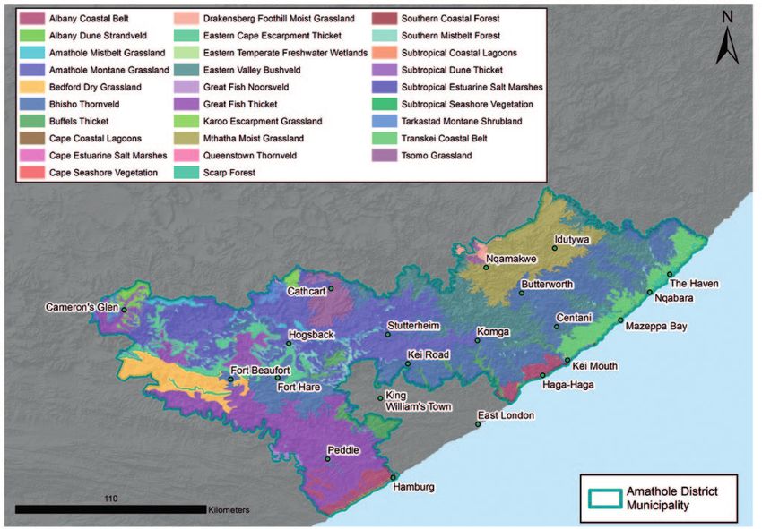
5 | Governance & Management���������������������������������������������������������������������������������������������������������������������� 34
         5.1           Policy framework����������������������������������������������������������������������������������������������������������������������������������������������������������������34
         5.2           Wetland management within Amathole District Municipality��������������������������������������������������������������������������36
                       5.2.1             Environmental Management Plan (EMP)������������������������������������������������������������������������������������������������� 36
                       5.2.2             Integrated Development Plan (IDP)����������������������������������������������������������������������������������������������������������� 36
                       5.2.3             Spatial Development Framework (SDF)���������������������������������������������������������������������������������������������������� 36
                       5.2.4             Amathole District Municipality Coastal Management Framework (CMF)���������������������������������������� 37

6 | Local and regional partnerships and programmes����������������������������������������������������������������������� 38

7 | Communication and Public Awareness������������������������������������������������������������������������������������������������ 39
         7.1           Communication and Education ������������������������������������������������������������������������������������������������������������������������������������39
         7.2           Public Participation and Awareness����������������������������������������������������������������������������������������������������������������������������39
Conclusion������������������������������������������������������������������������������������������������������������������������������������������������������������������������������������������������������40
Definitions������������������������������������������������������������������������������������������������������������������������������������������������������������������������������������������������������41
Acknowledgements�������������������������������������������������������������������������������������������������������������������������������������������������������������������������������������42
Resources��������������������������������������������������������������������������������������������������������������������������������������������������������������������������������������������������������43
Footnotes��������������������������������������������������������������������������������������������������������������������������������������������������������������������������������������������������������45
Annexures�������������������������������������������������������������������������������������������������������������������������������������������������������������������������������������������������������47

                                                                               Amathole District Municipality: WETLAND REPORT                                                                   I 2017            5
List of Acronyms and Abbreviations

ADM	         Amathole District Municipality             LAB         Local Action for Biodiversity
AFC	         Amathole Forestry Company                  MTSF        Medium Term Strategic Framework
AS	          Africa Secretariat                         NEMA        National Environmental Management
BGIS         Biodiversity Geographic Information                    Act 108 of 1998
             System                                     NEMBA       National Environmental Management
BSP	         Biodiversity Sector Plan                               Biodiversity Act 10 of 2004
CARA         Conservation of Agricultural               NEMPAA      National Environmental Management
             Resources Act 43 of 1983                               Protected Areas Act 57 of 2003
CBA          Critical Biodiversity Areas                NFEPA       National Freshwater Ecosystem
CBC          Cities Biodiversity Center                             Priority Areas
CEPA         Communication, Education and Public        NDP         National Development Plan
             Awareness                                  NGO         Non-Governmental Organisation
CIP	         Climate Information Portal                 NWA         National Water Act 36 of 1998
CMF          Coastal Management Framework               NWI         National Wetland Inventory
CSAG         Climate Systems Analysis Group             RDP         Reconstruction and Development
CSIR         Council for Scientific and Industrial                  Programme
             Research                                   SAIAB       South African Institute for Aquatic
DEA          Department of Environmental Affairs                    Biodiversity
DEDEA        Department of Economic Development         SALGA       South African Local Government
             and Environment Affairs                                Association
DWAF         Department of Water Affairs and            SANBI       South Africa National Biodiversity
             Forestry                                               Institute
DWS	         Department of Water and Sanitation         SDF         Spatial Development Framework
ECBCP        Eastern Cape Biodiversity Conservation     SPLUMA      Spatial Planning and Land Use
             Plan                                                   Management Act 16 of 2013
EIA          Environmental Impact Assessment            STEP        Subtropical Thicket Ecosystem Project
EMF          Environmental Management Framework         SWSA        Strategic Water Source Area
EMP	         Environmental Management Plan              UCT         University of Cape Town
EMS          Environmental Management System            UNFCCC	     United National Framework Convention
ESAs         Ecological Support Areas                               on Climate Change
GIS          Geographical Information System            WFW         Working for Wetlands
IAP	         Invasive Alien Plant                       WSA         Water Source Area
ICLEI	       ICLEI – Local Governments for              WULA        Water Use License Application
             Sustainability                             WWTW        Waste Water Treatment Works
IDP	         Integrated Development Plan

List of Tables
Table 1:     The condition of wetlands within Amathole District Municipality
Table 2:     Ecosystem services provided by wetlands within Amathole District Municipality
Table 3:      Role of wetlands in disaster risk mitigation within Amathole District Municipality
Table 4:      Legislation governing wetland management within Amathole District Municipality
Table 5:      Local and regional wetland related partnerships and programmes within Amathole District
              Municipality

6   2017   I Amathole District Municipality: WETLAND REPORT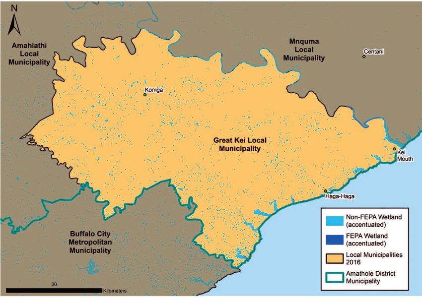
List of Figures

Figure 1       Amathole District Municipality in      Figure 20   Example of the water filtration
               the Eastern Cape, South Africa.                    capabilities of wetlands.
Figure 2       Kwelera River located within           Figure 21   Example of a residential
               Amathole District Municipality.                    development in a wetland in
Figure 3 & 4   Mottled soils indicative of a                      Stutterheim. During wet periods,
               wetland (left) and specially                       the water table is at surface level
               adapted wetland vegetation (right).                and creates poor living conditions
Figure 5       Wetland systems within South Africa.               and negatively impacts the residents.
Figure 6       The critically endangered Cape         Figure 22   A schematic representation of the
               parrot (Poicephalus robustus).                     hydrological buffer function of
Figure 7       Local Municipalities located within                wetlands.
               Amathole District Municipality.        Figure 23   Graph depicting the typical climate
Figure 8       Map showing the NFEPA and non-                     of the Amathole District Municipality.
               NFEPA wetlands within Amathole         Figure 24   Graph depicting the anticipated
               District Municipality.                             changes in average maximum
Figure 9       The Hogsback in the Amathole                       temperature patterns for
               Mountains.                                         Amathole District Municipality.
Figure 10      Number of known wetlands in            Figure 25   Graph depicting the anticipated
               the local municipalities within                    changes in average minimum
               Amathole District Municipality.                    temperature patterns for
Figure 11      The Great Fish Estuary.                            Amathole District Municipality.
Figure 12      Map of the Great Kei System            Figure 26   Graph depicting the anticipated
               located within Amathole District                   changes in total monthly rainfall
               Municipality.                                      patterns within Amathole District
Figure 13      Different vegetation types present                 Municipality.
               in Amathole District Municipality.     Figure 27   Amathole District Municipality
Figure 14      Dwarf Puddle Frog                                  developing a Wetland Strategy
               (Phrynobatrachus mababiensis).                     and Action Plan, with the aim of
Figure 15      Sharp-nosed Frog (Ptychadena                       incorporating it into the IDP.
               oxyrhynchus).                          Figure 28   Anton Listrom undertaking
Figure 16      Striped Grass Frog (Ptychadena                     municipal level awareness raising
               porosissima).                                      on the value of wetlands for local
Figure 17      Amatola Flat Gecko (Afroedura                      communities living in rural areas.
               amatolica).
Figure 18      Strategic Water Source Areas
               located within Amathole District
               Municipality.
Figure 19      Nguni cattle grazing on the
               foothills of the rural areas in
               Amathole District Municipality.

                                        Amathole District Municipality: WETLAND REPORT        I 2017       7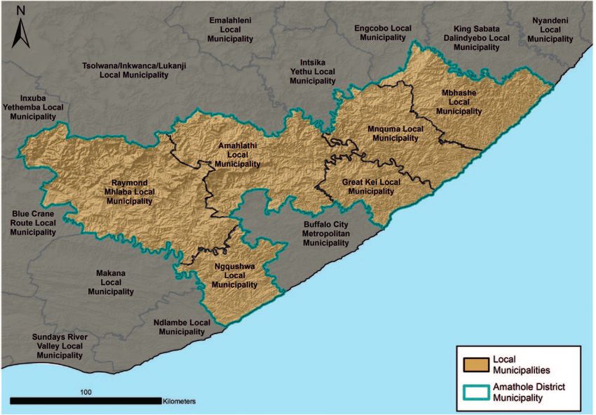
Executive Summary

Amathole District Municipality lies within the Eastern    vegetation types across the landscape. The highest
Cape Province with jurisdiction over a diverse range of   concentration and largest wetlands are found in
ecosystems, ranging from coastal dunes to forested        the wet Amathole and Tsomo Grassland areas of
hills in the hinterland. There are many sensitive and     Amahlathi and Nkonkobe Local Municipalities, and
conservation worthy areas within Amathole District        include important valley-bottom wetlands and
Municipality, such as subtropical thicket, wetlands,      wetland seeps. A smaller concentration of depression
river systems and cultural sites, all of which have       wetlands and wetland flats can be found within the
associated rare and endagered species. While              thicket areas. Most of the wetland ecosystems have
rich in natural, cultural and historical resources,       been severely or moderately modified from their
Amathole District Municipality is faced with a number     natural condition.
of challenges including addressing inequality and
the legacy of apartheid, unemployment, housing            Freshwater is South Africa’s most limiting natural
shortages, poverty and pollution of natural resources.    resource. Industrialization and urbanization as well
The growing needs of the increasing population in         as rapid population growth are the largest water
Amathole District Municipality have also resulted in a    users and are heavily affecting water management
growing demand for development. Amathole District         activities. It is imperative that South Africa develops
Municipality recognises that, although development        both a water-efficient economy together with a social
must be economically and socially acceptable, it          ethic of water conservation and ultimately a culture
is imperative that development challenges facing          of sustainability of water resource use.
Amathole District Municipality be addressed in an
environmentally sustainable manner.                       Currently there is no specific designated wetland
                                                          management authority or capacity for management
Biodiversity offers an immense opportunity to             within Amathole District Municipality. To streamline
support the municipality’s development path by            and improve the management of wetlands, Amathole
providing many free goods and services which              District Municipality is implementing the Local Action
contribute to municipal service delivery, water and       for Biodiversity: Wetlands South Africa (LAB: Wetlands
food security, and quality of life. Wetland ecosystems    SA) Project with support from ICLEI Africa Secretariat
have many benefits to society, such as purifying water,   (ICLEI AS). The LAB: Wetlands SA project aims to
controlling erosion and providing habitat for wetland     ensure the protection of priority natural wetland
dependent species. Wetlands however remain South          resources, thus enabling the supply of ecosystem
Africa’s most threatened ecosystems and continue to       services, and promoting resilient communities and
be poorly managed and destroyed. This is largely due      sustainable local economies under a changing climate
to their benefits being poorly understood, resulting      within South African local governments. Through the
in an urgent need to increase awareness of wetland        development of this Wetland Report, ICLEI AS will
importance and to incorporate natural wetland             assist Amathole District Municipality in identifying
resource considerations into municipal governance         the gaps in management and assist with devising
mechanisms and planning. The number of type               new and better wetland management strategies
of wetlands across Amathole District Municipality         going forward.
varies as a result of the climate, topography and

8   2017   I Amathole District Municipality: WETLAND REPORT
Introduction
South Africa is endowed with a rich wealth of The Local Action for Biodiversity: Wetlands South
biodiversity, which offers an immense opportunity Africa Project (LAB: Wetlands SA) is working with
to support the country’s development path by 11 municipalities throughout the country to build
providing many goods and services which contribute institutional capacity and develop local policies for
to municipal service delivery, water and food security, integrating biodiversity and specifically wetlands
and quality of life, especially under a changing climate. across local government departments. The project
Wetlands in particular, are high-value ‘ecological is implemented by ICLEI – Local Governments for
infrastructure’, providing critical ecosystem services Sustainability Africa Secretariat (ICLEI AS) through
such as clean water, clean air, food, medicines, water the Cities Biodiversity Center (CBC) with key partners
storage and habitat for biodiversity. Wetlands also such as SANBI, SALGA, Working for Wetlands and
play a role in disaster management, and could lessen DEA. The project is based on the globally-renowned
the negative effects of climate change through flood LAB Pioneer Programme methodology.
attenuation, temperature regulation and water and
food security. This report draws together the range of knowledge
about wetlands within Amathole District Municipality
Wetlands however are South Africa’s most threatened (Figure 1), and provides a detailed overview of the
ecosystems, with 48% of wetland ecosystems critically stakeholders and programmes working towards
endangered,1 resulting in an urgent need to increase improved wetland management in this region.
awareness of wetland importance and to incorporate
natural wetland resource considerations into
municipal governance mechanisms and planning.
Figure 1: Amathole District Municipality in the Eastern Cape, South Africa.
Amathole District Municipality: WETLAND REPORT I 2017 9Scope and Purpose of the Report
This Wetland Report is compiled by Amathole District and accountability for a greener, better Amathole
Municipality and ICLEI AS on behalf of Amathole District Municipality by:
District Municipality. The report includes information ●● Consolidating available wetland information in
pertaining to Amathole District Municipality, which Amathole District Municipality;
is one of the 7 districts in the Eastern Cape Province ●● Documenting the wetland resources within
of South Africa. The Municipality is situated in the Amathole District Municipality including:
central part of the Eastern Cape stretching along the –– Geographical information
Sunshine Coast from the Fish River Mouth, along the –– Geospatial information
Eastern Seaboard to just south of Hole in the Wall –– Biological aspects (general biological health
along the Wild Coast. status quo)
●● Identifying knowledge gaps on wetlands;
The Wetland Report captures information about ●● Identifying key stakeholders that impact on or are
wetlands within Amathole District Municipality. impacted by wetlands;
By merging existing wetland information, the ●● Identifying municipal departments that impact
municipality can identify knowledge gaps and priority or benefit from wetlands, discuss those impacts
areas for wetland management going forward. or benefits, and responsibilities and roles of
This report considers and promotes cross sectorial each department with regards to wetland
and ecosystem based approaches to wetland management;
management on a region wide basis, encourages ●● Identifying risks and opportunities in relation to
stakeholder participation and increases transparency wetland and service delivery.
Figure 2: Kwelera River located within Amathole District Municipality.2
10 2017 I Amathole District Municipality: WETLAND REPORT1 i What is a Wetland?
‘ etlands are land which is transitional between terrestrial and aquatic systems, where the water
W
table is usually at or near the surface, or the land is periodically covered with shallow water, and
which land in normal circumstances supports or would support vegetation typically adapted to
’
life in saturated soil.
National Water Act No. 36 of 1998
Figure 3 & 4: Mottled soils indicative of a wetland (left) and specially adapted wetland vegetation (right).3
In simpler terms, a wetland is a feature in the period (approximately one month) during the rainy
landscape which is saturated with water for a long season only. Vegetation associated with this type of
enough period that the soil conditions change wetland are predominantly grass species, as well as
(mottling as a result of the anaerobic conditions) and a mixture of species that occur in non-wetland areas
the vegetation shifts to respond to these changes.4 and hydrophytic plants that are largely restricted to
wetland areas. A seasonal wetland is saturated for
Six different types of wetlands occur across the most of the growing season. Vegetation associated
country. These vary based on the underlying with this type of wetland are predominantly sedges
geology and include seeps, depressions, wetland and grasses that are restricted to wetland areas,
flats, floodplain wetlands, channelled valley- usually < 1m tall. Lastly, a permanent wetland is
bottom wetlands and unchannelled valley bottom saturated all year round. This type of wetland is
wetlands.5 SANBI has compiled a detailed hydro- dominated by highly specialised aquatic plants
geomorphic classification system to assist with adapted to permanently wet conditions.6
wetland identification. An illustrative overview from
this document of the different types of wetlands is All wetland types can be classified as high value
included in Figure 5. ‘ecological infrastructure’ due to the large number
of ecosystem services that they provide. Wetland
Wetlands also vary on a temporal scale based on the ecosystem services can be classified into four
climate and season. As such, once a wetland type separate categories namely ‘provisioning services’,
has been established, it can then be categorised into ‘regulating services’, ‘cultural services’ and ‘supporting
either a temporary, seasonal or permanent wetland. services’.7 Provisioning services can be described as
A temporary wetland is saturated for a very short the products one can physically obtain from wetlands
Amathole District Municipality: WETLAND REPORT I 2017 111 What is a Wetland? (continued) Figure 5: Wetland systems within South Africa.8 such as fresh water, food and natural medicines. It should be noted that ecosystem services provided Regulatory services can be described as the benefits by wetlands come at no cost to the municipality one receives from the wetland such as stream flow and as such, all that needs to be done to ensure regulation, erosion control, water filtration and flood continued provision of these services is to protect and attenuation. Cultural services are the nonmaterial maintain local wetlands. However, the inappropriate benefits that one can obtain from wetlands such as management of wetlands, can cause a loss of wetland spiritual enrichment, sense of place and aesthetic area and subsequent loss of ecosystem services. experience. Lastly supporting services are the services This results in the municipalities having to invest provided that are necessary for the production of all in expensive infrastructure (e.g. water filtration other ecosystem services namely, nutrient cycling plants or flood barriers) to ensure the same level of and water cycling. Please refer to Section 3.7 of this service delivery. report for a detailed description of the ecosystem services that wetlands within Amathole District Municipality provide. 12 2017 I Amathole District Municipality: WETLAND REPORT
2    | What is Biodiversity?
‘    he variability among living organisms from all sources, including, terrestrial, marine and other
    T
    aquatic ecosystems and the ecological complexes of which they are part and also includes
    diversity within species, between species, and of ecosystems.
    National Environmental Management: Biodiversity Act No. 10 of 2004  ’
To expand on this, biological diversity or the shorter     area. For example, if a wetland becomes polluted and
more commonly used term biodiversity, is the variety       its ecological condition deteriorates, it is no longer
of genes, species and ecosystems on Earth, and the         able to function correctly and natural processes such
processes that maintain this diversity. It is the living   as providing food (e.g. fish), materials (e.g. reeds) and
species and natural processes that constitute nature.      water purification no longer take place. The real value
Rather than simply considering plant and animal            in the term biodiversity is that by describing the variety
populations (i.e. total numbers), biodiversity reflects    of life forms rather than total numbers, biodiversity
the variability of plants and animals and crucially,       can be used at any scale (e.g. for landscapes such
the processes by which they are supported, and the         as grasslands or a habitat such as a woodland or
functions that they deliver.                               koppie) to reflect the health of any area – not just
                                                           wild landscapes, but pockets of biodiversity such as
Essentially, as biodiversity includes natural processes,   wetlands, too.
it describes the health and functioning of a given

    Figure 6: The critically endangered Cape parrot (Poicephalus robustus) is a large, temperate forest
    dwelling parrot of the genus Poicephalus endemic to South Africa.9

                                           Amathole District Municipality: WETLAND REPORT                I 2017    13
3 | WAmathole
etlands and Biodiversity WITHIN
District Municipality
Figure 7: Local Municipalities located within Amathole District Municipality.
Amathole District Municipality occupies the central This section will provide information on existing maps,
coastal portion of the Eastern Cape Province and is information on the known key wetlands in the district
bordered by Sarah Baartman District Municipality as well as information on their health and status and
to the west, Chris Hani District Municipality to the key flora and fauna species associated with wetlands
north and OR Tambo District Municipality to the east. in Amathole District Municipality. It provides detail
Buffalo City Metropolitan Municipality lies within on the value of wetlands to the district and highlights
Amathole District Municipality along the Indian Ocean the key threats. Also included is information on the
border. The Amathole Mountain range borders the Amathole District Municipality’s Strategic Water
northern part of Amathole District Municipality whilst Source Areas.
the southern part of the district runs some 269 km
along the Indian Ocean, which accounts for 19.58%
of the districts’ jurisdictional boundary and roughly
34% of the Eastern Cape coastline. In total the district
covers a geographical area of 23 577 km².
14 2017 I Amathole District Municipality: WETLAND REPORT3.1 Mapping wetlands within Amathole District Municipality
Figure 8: Map showing the NFEPA and non-NFEPA wetlands within Amathole District Municipality.
Recognising the need to ensure that these important These can be found in the ECBCP handbook (2007)
natural resources are conserved, the Department available here: http://www.nda.agric.za/doaDev/
of Economic Development and Environment Affairs sideMenu/ForestryWeb/webapp/Documents/PF/
(DEDEA) together with the Department of Water ECBCPHandbookAug07.pdf.
Affairs and Forestry (DWAF) prepared the Eastern
Cape Biodiversity Conservation Plan (ECBCP). The The Amathole District Municipality’s Integrated
ECBCP identified and mapped Critical Biodiversity Development Plan (IDP) Review 2016 – 2017 includes
Areas (CBAs), and provided land use planning the area of land that is covered by wetlands in
guidelines that recommend biodiversity-friendly particular (Amahlathi: 4285.2 ha, Great Kei: 928.7 ha,
activities in priority areas. Mbhashe: 2609.6 ha, Mnquma: 1612.4 ha, Raymond
Mhlaba: 4479.6 ha). However, these reflect very low
The CBAs were identified through systematic percentages of the total area (between 0.5 – 1%).
biodiversity analysis undertaken for the ECBCP in Given that the coverage of wetlands across South
2007 as well as through other projects such as the Africa is an average of 2.4%,10 it is likely that the
Sub-Tropical Thicket Ecosystem Project (STEP). area has not been sufficiently mapped and that
The ECBCP developed two maps, one showing the more detailed mapping and analysis is required for
terrestrial CBAs and the other the aquatic CBAs. Amathole District Municipality.
Amathole District Municipality: WETLAND REPORT I 2017 153.1 Mapping wetlands WITHIN Amathole District Municipality
(continued)
Although CBA maps are in included in the ECBCP The NWI acts as a good starting point for
and wetlands are included in the Amathole understanding where wetlands are located within
District Municipality IDP, there are currently no the landscape. This NWI was however developed at
ground-truthed maps of wetlands within the a national scale from aerial imagery and as a result
district. At this stage, wetland maps for Amathole the resolution (accuracy) is not always detailed
District Municipality can be derived from the SANBI or accurate enough for inclusion in ground level
Biodiversity Geographical Information System decision making processes around land use planning.
(SANBI BGIS) National Wetlands Inventory (NWI). The SANBI NFEPA maps however are among the best
The NWI aimed to identify a national network of tools currently available to inform land-use planning.
national freshwater ecosystem priority areas (NFEPA) These can be accessed here: http://bgis.sanbi.org/
including rivers and wetlands, and map the extent, MapViewer.
location and state of these systems across the country.
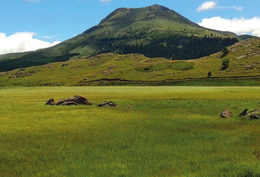
Figure 9: The Hogsback in the Amathole Mountains.11
16 2017 I Amathole District Municipality: WETLAND REPORT3.2 Wetland Ecosystem Health and Condition
The term ‘Wetland Ecosystem Threat Status’ Amathole District Municipality have been severely or
indicates the state of a wetland (i.e. the degree to moderately modified from their natural condition.
which it is still intact or alternatively the degree to Any further transformation of wetlands must be
which it has been impacted with resultant loss of avoided, and the focus should be made on urgent
structure, function and subsequent ability to provide wetland ecosystem rehabilitation initiatives.
ecosystem services). Most of the wetlands within
TABLE 1 THE CONDITION OF WETLANDS WITHIN AMATHOLE DISTRICT MUNICIPALITY
Local Municipality Conditions Area (ha) % wetlands areas
Amahlathi Natural/Good condition 92.6 8.0
Moderately Modified condition 136.1 11.8
Heavily/Critically Modified condition 924.5 80.2
Greate Kei Natural/Good condition 17.1 3.2
Moderately Modified condition 28.0 5.2
Heavily/Critically Modified condition 492.4 91.6
Mbhashe Natural/Good condition 60.6 15.2
Moderately Modified condition 100.3 25.2
Heavily/Critically Modified condition 237.2 59.6
Mnquma Natural/Good condition 99.9 18.7
Moderately Modified condition 136.2 25.5
Heavily/Critically Modified condition 297.1 55.7
Ngqushwa Natural/Good condition 74.8 15.0
Moderately Modified condition 103.4 20.8
Heavily/Critically Modified condition 319.9 64.2
Raymond Mhlaba Natural/Good condition 95.0 10.2
Moderately Modified condition 64.0 6.7
Heavily/Critically Modified condition 1650.1 183.1
3.3 Key Wetlands within the Amathole District Municipality
The number of type of wetlands across Amathole found within the thicketed areas of the municipality.
District Municipality varies as a result of the climate, The driest areas of Amathole District Municipality,
topography and vegetation types across the which comprise predominantly of Bushveld
landscape. The highest concentration and largest and Thornveld (in Mnquma and Mbhashe Local
wetlands are found in the wet Amathole and Tsomo Municipalities as well as parts of Amahlathi Local
Grassland areas of Amahlathi and Nkonkobe Local Municipality), have the least number of wetlands.
Municipalities, and include important valley-bottom However, some seep wetlands are found in the
wetlands and wetland seeps. A smaller concentration Umtata Moist Grassland of northern Mnquma and
of depression wetlands and wetland flats can be Mbhashe Local Municipalities.
Amathole District Municipality: WETLAND REPORT I 2017 173.3 Key Wetlands within the Amathole District Municipality
(continued)
Figure 10: Number of known wetlands in the local municipalities within Amathole District Municipality.12
3.3.1 The Great Fish Estuary 3.3.2 The Great Kei System
The Great Fish Estuary is of great importance as it The Great Kei Catchment (20 485 km²) drains the
forms the southern boundary between Amathole northern slopes of the Amathole Mountain range and
District Municipality and Cacadu District Municipality. the southern slopes of the Stormberg/Drakensberg
This is the 13th most important estuary in South Africa range at an altitude of 2400 masl. The Kei Catchment
due to its large size, significant habitat and biological ranges from Queenstown to the Indian Ocean within
diversity. It is imperative that the system be effectively Amathole District Municipality. The upper Great Kei
managed by both district municipalities to ensure River is centered around Queenstown, whilst the
that the system is protected and ecosystem services middle and lower reaches of the Great Kei River
continue to be provided to both municipalities. are characterised by a deeply incised valley, which
meets the Indian Ocean at the Kei Mouth north of
East London. 13
Figure 11: The Great Fish Estuary. Figure 12: Map of the Great Kei System located
within Amathole District Municipality.
18 2017 I Amathole District Municipality: WETLAND REPORT3.4 Key Flora and Fauna of the Amathole District Municipal
Wetlands
Figure 13: Different vegetation types present in Amathole District Municipality.14
The Eastern Cape Province is globally recognised for 3.4.1 Flora
its high biodiversity value and scenic beauty. It has Amathole District Municipality encompasses an
the highest biodiversity of any of the Provinces within extremely diverse geographical area ranging
South Africa and includes no less than six biomes: from the Amathole Mountain Range down to the
Forest, Fynbos, Nama Karoo, Savanna, Succulent Wild Coast. The associated diverse landscape and
Karoo and Thicket. In addition, three centres of climate results in a variety of habitats. Amathole
biological endimism can also be found within the District Municipality itself contains five biomes that
Eastern Cape: Albany Thicket, the Drankensberg describe the biotic communities in the area. These
Centre and the Pondoland Centre. As a result, many are Savanna (34.5%), Grasslands (31.5%), Albany
sensitive and conservation worthy areas can be found Thicket (29.6%), Indian Ocean Coastal Belt (3.7%) and
throughout the Eastern Cape including subtropical Forests (0.6%). The biomes are further separated into
thicket, wetlands, river systems, cultural sites as well different vegetation types that describe the types of
as coastal areas, all of which have associated rare and communities present.14
endangered species. This includes 6164 plant species,
156 mammal species, 384 bird species, 51 amphibian
species and 57 reptile species.
Amathole District Municipality: WETLAND REPORT I 2017 193.4 Key Flora and Fauna of the Amathole District Municipal
Wetlands (continued)
3.4.2. Fauna The Eastern Cape Rocky Fish (Sandelia bainsii) is listed
A number of rare butterflies occur within Amathole as a rare and endangered freshwater fish species
District Municipality including several types of forest found only in a small portion of the Eastern Cape river
and thick bush species (Aslauga australis, Bowkeria systems in South Africa. The greatest threat to this fish
phosphor and Abantis bicolor) as well as grassland species is a loss of habitat however other pressures,
species (Poecilimitis penningtoni and Metilsella syrinx). such as invasive fish and vegetation, excessive salt
deposition and water flow obstruction (usually man-
Five threatened freshwater dependent species occur induced) also pose dangers to the survival of this rare
within the district. Two of these are fish species; namely fish species.
the Border Barb (Barbustrevelyani) and the Eastern
Cape Rocky Fish (Sandelia bainsii). One is a damselfly Other interesting species endemic to the areas include
species, namely the Amathole Malachite (Chlorolestes the Dwarf Puddle Frog (Phrynobatrachus mababiensis),
apricans), and two are amphibian species, namely the the Sharp-nosed Grass Frog (Ptychadena oxyrhynchus),
Amathole Toad (Vandijkophrynus amatolicus) and the Striped Grass Frog (Ptychadena porosissima) and the
Hogsback Chirping Frog (Anhydrophryne rattrayi). Amatola Flat Gecko (Afroedura amatolica).
Figure 14, 15, 16 and 17: Dwarf Puddle Frog (Phrynobatrachus mababiensis)15 (top left), Sharp-nosed Frog
(Ptychadena oxyrhynchus)16 (top right), Striped Grass Frog (Ptychadena porosissima)17 (bottom left), and Amatola
Flat Gecko (Afroedura amatolica)18 (bottom right).
20 2017 I Amathole District Municipality: WETLAND REPORT3.4 Key Flora and Fauna of the Amathole District Municipal
Wetlands (continued)
The Amathole District Municipal area has rich bird which inhabits the indigenous forests of the Eastern
diversity. A significant number of threatened or Cape. Other mammals found within Amathole
vulnerable species occur in the area, including: District Municipality include the Samango Monkey
●● Cape Parrot (Poicephalus robustus) classified as (Cercopithecus albogularis), which can only be found
Critically Endangered; in forests along the Amathole Mountain Escarpment
●● White-backed Night Herron (Gorsachius and within the coastal forests; as well as the the
leuconotus) classified as Vulnerable; South African Hedgehog (Atelerix frontalis), Leopard
●● African Finfoot (Podica senegalensis) classified (Panthera pardis), Blue Duiker (Philantomba monticola)
as Vulnerable; and the Tree Dassie (Dendrohyrax arboreus).
●● African Black Oyster Catcher (Haematopus
moquini) classified as Near Threatened. The Samnago Monkey is classified as Near Threatened
whilst the South African Hedgehog, Leopard,
Amongst the mammal species found within Amathole Blue Duiker and Tree Daissie are all classified as
District Municipality, the only species endemic to the Nationally Vulnerable.
area is the Giant Golden Mole (Chrysospalax trevelyani)
3.5 Strategic Water Source Areas and Water Management Areas
within Amathole District Municipality
Water Source Areas (WSAs) are sections of the The Amathole Mountain SWSA includes the Great Kei,
landscape that provide a disproportionate amount Keiskamma, Great Fish, Tyume and Amatele Rivers
of run-off compared to the rest of a given catchment and is the main water source for Bisho, Fort Beaufort,
area. South Africa’s WSAs are largely spread across Grahamstown and Queenstown. The Pondoland
the country, however they are generally found in the Coast SWSA includes the Mzimvubu, Mngazi, Mntafufu
highest parts of the landscape, receiving high amounts and Msikaba Rivers and is the main water source for
of rainfall. Downstream users and ecosystems are OR Tambo District Municipality. The Eastern Cape
highly dependent on the healthy functioning of Drakensberg SWSA includes the Mzimvubu, Orange,
WSAs in order to sustain good quality water supplies Bokspruit, Thina, Klein Mooi and Mthatha Rivers and
for human consumption as well as agriculture. is the main water source for Umtata.
Disrupting the water supply from the WSAs therefore
has the potential to have a hugely negative impact on The main threats to all the SWSAs within and
national water and food security.19 near Amathole District Municipality include land
degradation and fire. The Amathole SWSA is however
Twenty one separate WSAs have been identified also threatened by invasive alien vegetation whilst
in South Africa and can be divided into those the Pondoland Coast SWSA is also threatened by
of local importance (5) and those of strategic coal mining.
national importance (Strategic Water Source Areas/
SWSAs, 16). Three SWSAs are located within and just
outside of Amathole District Municipality; namely the
Amathole Mountain SWSA (within the district) and the
Pondoland Coast and Eastern Cape Drakensberg (just
outside the district). These are illustrated in Figure 18.
Amathole District Municipality: WETLAND REPORT I 2017 213.5 Strategic Water Source Areas and Water Management Areas
within Amathole District Municipality (continued)
Figure 18: Strategic Water Source Areas located within Amathole District Municipality.20
3.6 Catchment Management within Amathole District
Municipality
3.6.1 Inter-basin water transfer of the only WMAs within the district where water
schemes resources are not 100% allocated for municipal use.
The Fish and Sundays Rivers are augmented by inter-
basin water transfers from the Gariep Dam (Orange Water resource management issues in the Eastern
River Basin). As with all Water Management Areas Cape include:
(WMAs) in South Africa, over-abstraction is a major ●● Over-abstraction of existing resources
issue in terms of water resource management as for irrigation, manufacturing and urban
it threatens ecological stream flow requirements. requirements, resulting in deterioration of
Whilst most water from rivers located within the Fish downstream water quality, quantity and
and Tsitsikamma WSAs is fully allocated for municipal ecological integrity;
use, the Mzimvubu to Keiskamma WMAs remain two
22 2017 I Amathole District Municipality: WETLAND REPORT3.6 Catchment Management within Amathole District
Municipality (continued)
●● Threats to water quality, quantity and aquatic The Eastern Cape Province is strongly dependent on
ecosystem integrity due to basin degradation; the quality and quantity of the water resources in the
land-use change in basins; relevant Water Management Areas. It is therefore
●● Threats to water quality from sub-standard critical that those responsible for water services
effluent releases as a result of poorly managed infrastructure manage these resources effectively.
and poorly maintained waste-water treatment They should also take into account the future climate
works and sewage reticulations; change scenarios related to water resources as the
●● Threats to ecological integrity of fresh-water impacts of climate change are likely to have secondary
resources due to invasive species and damming and tertiary impacts on the technical and operational
of existing resources. integrity of installed water and services infrastructure.
3.7 The Value of Wetlands within Amathole District
Municipality
The Amathole District Municipality 2016 – 2017 Wetland ecosystem services can be classified into four
Integrated Development Plan (IDP) notes that separate categories namely ‘provisioning services’,
wetlands contribute to the local economy by ‘regulating services’, ‘cultural services’ and ‘supporting
producing resources, enabling recreational activities services’. Provisioning services can be described as
and providing other benefits, such as pollution the products one can physically obtain from wetlands.
control and flood protection. The availability of water Regulatory services can be described as the benefits
at the appropriate time, in the appropriate quantity one receives from the wetland. Cultural services are
and with the appropriate quality is a fundamental the nonmaterial benefits that one can obtain from
requirement for the sustainable development of local wetlands. Lastly supporting services are the services
municipalities. Water security is widely regarded as provided that are necessary for the production of all
the key natural resource challenge facing humanity. other ecosystem services.
Wetlands are crucial for maintaining the water Please refer to Table 2 below for a detailed description
cycle. All wetland types can be classified as high of the ecosystem services that wetlands within
value ‘ecological infrastructure’ due to the large Amathole District Municipality provide.
number of ecosystem services that they provide.
TABLE 2 E
cosystem services provided by wetlands within Amathole District
Municipality
Ecosystem Service Ecosystem Service Description/ Case Study
Type
Food Wetlands provide food in the form of plants and fish.
Fresh Water Wetlands retain water. They also filter water which can be used for
Provisioning water for drinking and irrigation.
Fibre and Fuel Wetlands provide raw materials such as wood, reeds and peat.
Medicinal products Many plants within wetlands can be used for medicinal purposes.
continued
Amathole District Municipality: WETLAND REPORT I 2017 233.7 The Value of Wetlands in the Amathole District Municipality
(continued)
TABLE 2 E
cosystem services provided by wetlands within Amathole District
Municipality
Ecosystem Service Ecosystem Service Description/ Case Study
Type
Climate regulation Wetlands store carbon and other greenhouse gasses preventing
them from being released into the atmosphere.
Water regulation Wetlands absorb and store storm water much like a sponge and
slowly release it over time. This reduces sediment loss and reduces
(hydrological flows)
flooding of areas down-stream. Wetlands also help with ground
water recharge and discharge.
Water purification and Wetlands have the ability to retain and remove excess nutrients
waste treatment and pollutants from the water. Wetlands also remove bacteria and
Regulatory
pesticides which can contribute to ill-health in humans and animals
if ingested.
Erosion control Wetland plants retain sediment that would otherwise be carried
downstream and deposited in dams and floodplains.
Natural hazard Wetlands control floods and also offer storm protection by slowing
regulation water runoff thus reducing the potential for severe flooding
incidents downstream.
Pollination Wetlands provide habitat and breeding ground for pollinators (both
insects and birds).
Spiritual Wetlands are seen as places of worship as well as areas where
baptisms can take place in a natural setting.
Recreational Wetlands provide opportunities for recreational activities (e.g.
boating and fishing) and ecotourism (e.g. birding ad hiking trails).
Cultural
Wetlands improve the quality of life in communities.
Aesthetic Natural wetlands systems are beautiful and have high aesthetic
value.
Educational Wetlands provide opportunity for learning at a primary, high school
and university level.
Soil formation Wetlands retain sediment and organic matter providing perfect
conditions for soil formation.
Supporting Nutrient cycling Storage and recycling, processing and acquisition of nutrients.
Biodiversity Wetlands provide critical habitat for a variety of flora and fauna; in
particular, wetlands provide breeding ground for frogs, insects, fish
and birds.
It should be noted that the numerous ecosystem cause a loss of wetland area and subsequent loss of
services provided by wetlands come at no cost to the ecosystem services. This results in the municipalities
municipality and as such, all that needs to be done having to invest in expensive infrastructure (e.g.
to ensure continued provision of these services is water filtration plants or flood barriers) to ensure the
to protect and maintain local wetlands. However, same level of service delivery.
the inappropriate management of wetlands, can
24 2017 I Amathole District Municipality: WETLAND REPORT3.8 Threats to Wetlands
Despite the significant benefits that wetlands provide
in terms of ecosystem services, 50% of wetlands in
South Africa have already been lost and 48% of the
remaining wetlands are critically endangered and/
or degraded. This loss is a direct result of deliberate
draining of wetlands, development and expansion
(both urban and agricultural) and pollution.
Damage to wetlands results in increasingly limited
functionality and subsequently a decrease in the
ability to provide valuable ecosystem services.
The Amathole District Municipality IDP notes that
wetlands are currently utilised in an unsustainable
manner throughout the municipality.
Figure 19: Nguni cattle grazing on the foothills of
Following verbal communications with active the rural areas in Amathole District Municipality.21
stakeholders working within Amathole District
Municipality, it became clear that wetlands face a
significant number of threats all of which have the
ability to either destroy the wetland entirely or severely
compromise function and provision of ecosystem
services. The most significant threats to the wetlands
located within Amathole District Municipality include:
●● Invasive alien plants;
●● Erosion;
●● Development within & around wetlands;
●● Pollution and excess nutrients seeping into
wetland areas;
●● Draining of water;
●● Over grazing/tramping particularly by cattle; and
●● Lack of buffer zones next to wetlands.
Figure 20: Example of the water filtration
capabilities of wetlands.22
Amathole District Municipality: WETLAND REPORT I 2017 25You can also read