Monkton Park Management Plan - SUMMER 2020 - SPRING 2026 Produced by Wild Landscapes of Wiltshire Wildlife Trust in partnership with Chippenham ...
←
→
Page content transcription
If your browser does not render page correctly, please read the page content below
Monkton Park
Management Plan                                                               2020

SUMMER 2020 – SPRING 2026
Produced by Wild Landscapes of Wiltshire Wildlife Trust in partnership with
Chippenham Town Council

                                                                                     0
Control Sheet
                   Name                                                      Organisation
 Author/s          Chelsie Phillips and Nick Self                            Wild Landscapes, Wiltshire Wildlife
                                                                             Trust Ltd.
 Contributors      Will Tidmarsh – Head of Environmental Services            Chippenham Town Council
                   Jake Bailey – Arboricultural Officer

  Version         Date           Modified by              Approved by               Comment/reason/s
     #1         02/02/21              n/a                    CP/NS                        First version

Disclaimer
This report has been prepared by Wild Landscapes, of Wiltshire Wildlife Trust Ltd. with all reasonable skill, care
and diligence, in line with requirements of the client, Chippenham Town Council. This report has been
prepared by Wild Landscapes for the sole use of the client and in connection with the development proposals
described – this report cannot be relied upon by any third party without express written consent by both Wild
Landscapes and the client. This is a technical report and does not represent legal advice/ opinion. Wild
Landscapes retain the right to re-publish data obtained and submit those species records produced during
any ecological studies to the local recording centre. Copyright © This report is the copyright of Wild
Landscapes. Any unauthorised reproduction or usage of material from this report is prohibited.

                                                                                                                1
Document outline

Preface

         Terms used within this document

         Purpose of the Land Management Plan

Management Strategies

         Area 1&2: Emery Gate and Formal Parkland --------------------------------------------------                  Page 1

         Area 3: Golf Course -------------------------------------------------------------------------------------    Page 9

         Area 4: Lower Riverside Meadow ------------------------------------------------------------------            Page 12

         Area 5: Baydons Wood --------------------------------------------------------------------------------        Page 31

         Area 6: Upper Riverside Meadow -----------------------------------------------------------------             Page 35

         All Areas: River Avon Bankside Habitat ----------------------------------------------------------            Page 39

Monitoring

         Essential monitoring -------------------------------------------------------------------------------------   Page 46

         Ecological monitoring --------------------------------------------------------------------------------       Page 47

All Areas: Schedule of Works ----------------------------------------------------------------------------------       Page 50

Supporting Documents (not included within this document)

                   Preliminary Ecological Appraisal of Monkton Park

                   Public Engagement Event Series Feedback

                   Environment Agency Statement on River Avon

                   WWT Water Conservation Team Initial Report

Key Stakeholders and Contributors List

                                                                                                                                2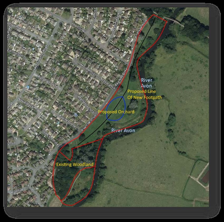
Preface

Terms used within this document

   •   Scrub (vegetation): A general term for vegetation dominated by shrubs, i.e. low woody plants, which
       typically       forms       an        intermediate community between             grass       or       heath
       and woodland. Successional change is not necessarily implied, though the term is often used for the
       transitional stage in succession to climax woodland when shrubby plants predominate.
   •   Neutral Grassland (habitat): Vegetation dominated by a range of grasses and herbs on a range of
       neutral soils usually with a pH of between 4.5 and 6.5. Includes dry hay meadows and pastures,
       together with a range of grasslands which are periodically inundated with water or permanently moist.
   •   Habitat Mosaic/Matrix: An area or site comprised of multiple habitat types to offer the greatest
       biodiversity.
   •   Woodland: Land with more than 25% cover of trees more than 5m in height. Also includes coppiced
       woodlands, recently felled but not cleared.
   •   Wet Woodland: Wet woodland occurs on poorly drained or seasonally wet soils, usually with Alder
       (Alnus glutinosa), Birch (Betula spp.) and Willows (Salix spp.). It can be found on floodplains, along
       streams and hillside flushes etc.
   •   Hedgerows: A boundary line of shrubs, provided that at least at one time were stock proof and more
       or less continuous.
   •   Dense Scrub: Patches of scrub less than 5m in height with continuous (90 %~) cover. I.e. Blackthorn
       scrub (Prunus spinosa), Bramble scrub (Rubus fructicosus agg.) etc.

Purpose of the Land Management Plan

Land management plans are produced to provide revised schedules of works to ensure sites are well
managed for their defined purpose. In this case Monkton Park is a valuable and historic public green space
used for recreation and leisure. It has also been assessed and evaluated for its benefits to local wildlife
populations and so this management plan will aim to address management practices beneficial for both
wildlife and people. This land management plan has been formed from through the undertaking of site
assessments, a pre-ecological appraisal, public engagement sessions and close liaison with Chippenham
Town Council and the Environment Agency. It aims to provide a well-considered plan to continue to develop
and improve the site and the range of habitats which fall within its boundaries over the next 3-5 year period,
subject to review. For the purpose of this management plan, Year 1 refers to Summer 2020-March 2021; Year
2 onwards will then refer to April to April (12 month) schedules of work. With Year 1 essentially offering less than
a full year, this will be reflected by a lessened work schedule.

                                                                                                                  3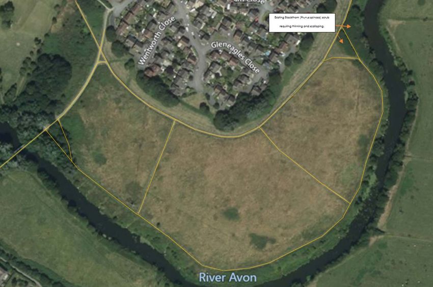
Management Strategies
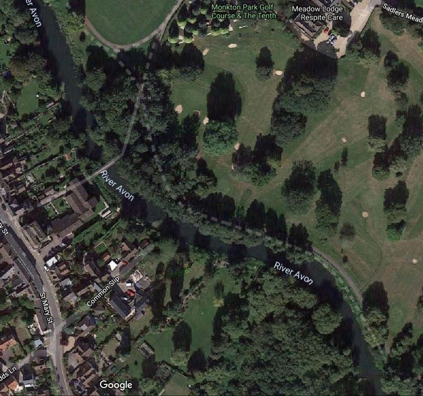
Areas 1 & 2: Emery Gate and Formal Parkland
Figure 1: Edited Satellite photograph of the formal parkland at Monkton Park
(Bing Maps 2021)
Overview of Area
The formal parkland at Monkton Park is an urban greenspace that is provided for the recreational enjoyment
of the people of Chippenham. For most of these people Emery Gate is the first point of contact in their use of
the park. Therefore, this area is important in setting out the desired ambience and should contain information
about ways that the public may interact with the park.
Monkton Park is linear in nature and consists of two main areas either side of the River Avon. Large parts of
the open areas are used during a number of town events, such as the Folk Festival and this must be taken
into account when planning the management of the area as a whole.
Current management practice is to cut the grass short during the spring and summer season as this
discourages pest species and allows for picnics and sporting activities. The objective in this area is to continue
with the current routine maintenance schedule, but introduce prescriptions that will improve biodiversity,
whilst enhancing the formal nature of the park and its enjoyment by people.
1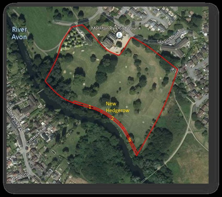
Project proposals
Signage
Interpretive material in the form of a free-standing, lectern type board (as shown in the example below) is an
effective way to guide visitors around a nature reserve or public amenity site.

The information panel should tell the story of the site and inform the reader of the things that make it
interesting. This can include information on management practices, and how the public should interact with
the site.

                     Figure 2: Example of a lectern type interpretation board (Author’s own 2019)

A number of these types of boards are proposed, at all the main entrances to Monkton Park. In addition a
further board is to be placed near to the foot-bridge, accessed from Emery Gate car park, as a proportion
of visitors to the park will enter it via that route. The positions of all boards are shown below.

                  Figure 3: Edited Satellite photograph showing all board positions (Bing Maps 2021)

                                                                                                            2
Town Bridge Bankside
The preliminary site assessment and public consultation indicate that there is an issue with the public feeding
bread to the ducks and pigeons on the bank of the River Avon adjacent to the Town Bridge. This is creates
an area that is unsightly and overrun with rats, in addition bread is bad for wild birds and pollutes the river.

The area of bank in question should be landscaped to create tiers which can then be formally planted and
managed with native wildflowers and shrubs. This will discourage people from feeding the birds and create
a more pleasantly aesthetic area. It is important to provide an alternative option for people to feed the birds
otherwise the issue will be recreated just upstream. A bird seed dispenser can be installed on the bridge or
local businesses can sell bird seed.

In addition signage should be installed on the bridge to let people know the importance of feeding the right
food, where they can get it and that they should feed the ducks off the bridge.

                     Figure 4: Edited Satellite photograph showing project area (Bing Maps 2021

Improvements to historic water course
This area, known locally as the ‘Black Lagoon’, is the site of a historic watercourse that has been blocked up
during development of the town centre. It is now a site that lies wet but is disconnected from the river by a
stone wall. This provides the opportunity for wet habitat which has high value for invertebrates, birds and
amphibians.

The area is over-shaded preventing vegetation growth, and the trees provide a secluded area for nuisance
behaviour. The trees in this area should be managed to let light into the area. Debris can be cleared and the
area landscaped to create a wetland or pond habitat. There may be some native seeds in the seedbank

                                                                                                                   3
but some additional planting of species such as common reed (Phragmites australis) is recommended to
encourage colonisation.

                 Figure 5: Edited Satellite photograph showing area of watercourse (Bing Maps 2021)

Routine Maintenance
In the formal park areas, the aim of the routine grass cutting regime is to establish a welcoming space, which
is clean and well maintained. To achieve this, current practice is to cut all amenity grassland every two weeks,
depending on weather conditions. This creates a close-cut, grass sward that is hard-wearing and suitable for
a range of leisure and sporting activities.

This routine grass cutting regime is to be continued for the duration of the management plan cycle and into
the future. Although various changes are being made across the formal park area to improve biodiversity,
this must be carried out without impeding on the primary objective of creating an area where people can
relax and spend their leisure time.

However, during public consultation a number of areas were highlighted where prompt management of
bramble, shrubs, and other vegetation would ensure adequate public access at all times. These areas are
highlighted in the diagram below.

                                                                                                              4
Figure 6: Edited Satellite photograph showing highlighted areas for management
                                                  (Bing Maps 2021)

Tree Planting
Parks are one of the few locations where minimal intervention is to be advocated as trees should be
encouraged to develop to maturity and have a natural canopy form. Where management is necessary the
priority for Monkton Park’s trees is public safety. The trees in Monkton Park were last internally inspected in 2019
and all priority recommended works carried out.

The formal parkland in this area has a sense of enclosure with trees around the majority of the park perimeter
except for the open area to the south and east of the Olympiad and the newly built car park. However, most
of the trees are old and there are no signs of planting within, perhaps, the last 30 or 40 years, therefore there
is little in the way of next generation trees to come through.

There are three areas, shown in the diagram below that will benefit from additional planting. This is especially
true of area 1, which will help screen off the new car park building. Some minor, more open, planting of
individual saplings in the areas marked with an asterisk, could also be beneficial.

There are many trees suitable for a formal area of parkland and these include:

   •   Red Maple (Acer rubrum) an ornamental specimen tree moderately tolerant of waterlogging, this is a
       good option to replace the declining specimen sycamores lower down the slope in the formal park
       area.
   •   Beech (Fagus sylvatica) are often planted in parks. There are variations with purple leaves.
   •   Small leaved lime (Tilia cordata) is a native species ‘next gen’ understorey planting option for the
       existing European lime avenue. Great for bees and will diversify the species mix here.

                                                                                                                  5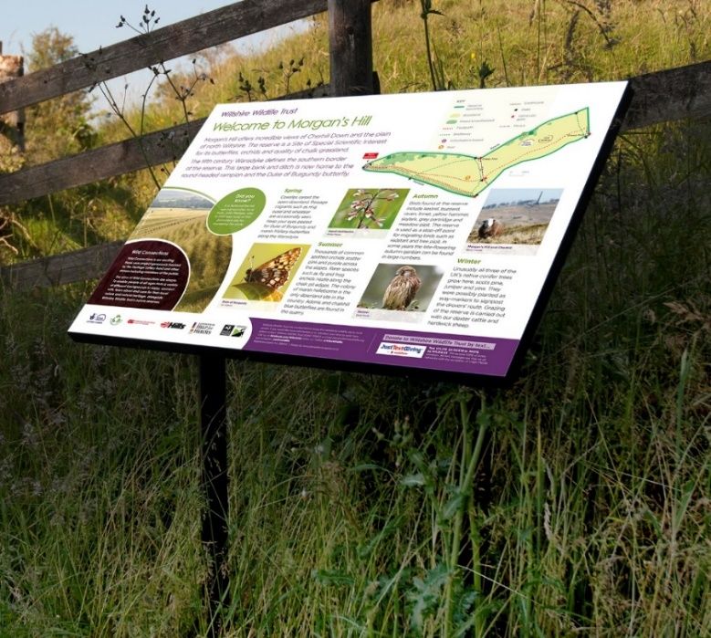
•   London plane (Platanus x acerifolia) is the most frequent plane tree in the UK and is a common park
       and street tree.
   •   Cherry flowering cherries such as pink flowering Prunus ‘Kanzan’ are grown for their colour in spring
       and autumn.
   •   Pedunculate Oak (Quercus robur) and Sessile Oak (Quercus petraea) will be the main, large
       canopied ‘next gen’ trees, with the view of preparing for the decline of the large proportion of ash,
       which currently fulfil this role.
   •   Swamp Cypress (Taxodium distichum) is a drought and waterlogging tolerant species, to
       complement the ‘formal park’ feel of the existing black pine alongside the river, and provide
       for their eventual decline.
   •   Red Oak (Quercus rubra), Scarlet Oak (Quercus coccinea) and Pin Oak (Quercus pallustris) are
       interesting ornamental varieties of oak for ‘one off’ specimen planting where appropriate, for
       example to provide for the decline of the veteran horse chestnut on the slope above the play area
       (these aren’t so tolerant of waterlogging).

                Figure 7: Edited Satellite photograph showing areas of new planting (Bing Maps 2021)

Pollinator Planters and Wildflower Areas
In the Preliminary Ecological Appraisal the formal parkland was highlighted as an area that would benefit
from an increase in annual and perennial wildflowers and bulbs, which would add colour and improve public
interest, whilst also being beneficial to pollinators such as butterflies and bees.

Public consultation dictated that there were a number of constraints upon where these features could be
sited. The whole area is used periodically for public events which limits where features can be placed so as
not to impede access. Therefore, the prescribed solution is to combine two fixed, wildflower areas with a
                                                                                                          6
number of wooden planters that could be moved if necessary. The suggested planters are large, rectangular,
raised beds, which can be moved by a forklift truck or tractor and sited, initially, along the riverside path, with
enough room for cutting equipment to traverse each side. An example can be seen below.
Figure 8: Example large planter (Primrose 2021)
To the south-east of the Olympiad sports centre is a small area which is currently used as an adhoc car-park
and was highlighted during public consultation as an area that should be returned to use by the park.
Therefore, this was selected to become the first wildflower area. The hard standing will be removed and an
annual mix will be sown for immediate blooms of colour in the first year. Bollards will be installed to ensure
that vehicles can no longer access the area.
The second wildflower area will be located in a rough triangle between the riverside path and the golf course,
at the south end of the formal park. A formal bed will be turf cut and rotavated, then sown with a suitable
mix of perennial wildflowers. A small fence will be required around the area to exclude the public during the
winter months and regular weeding and maintenance will be required to keep this area in good condition.
Figure 9: Edited Satellite photograph showing new wildflower planting (Bing Maps 2021)
7Schedule of works
Project Task Who Frequency Timing YEAR 1 YEAR 2 YEAR 3 YEAR 4 YEAR 5
Signage Manufacture and install 5-8 boards CTC Once Aug
Town Bridge Bankside Signage CTC Once Apr
Implement bird-feed options CTC Once Apr
Bankside improv ements CTC Once Sep - Oct
Historical W atercourse Tree & shrub management CTC Once Nov - Feb
W atercourse improv ements CTC Once Nov - Feb
Complementary planting CTC Once Nov - Feb
Routine Maintenance Mowing of existing grassland CTC 2x pm Mar - Nov
Routine exisiting tree health checks CTC Biennial Summer
Ensure routine island maintenance CTC Monthly Mar - Oct
Tree Planting Planting of sapling trees and protection CTC Once Nov - Mar
Monitor sapling health & maintain CTC Monthly Apr - Nov
Pollinator Planters Build and install planters CTC Once Sep
Sow/plant seeds/perennials CTC Once Sep - Oct
Re-seeding/additional planting CTC Once Sep - Oct
De-weeding / general maintenance CTC monthly May - Nov
W ildflower Areas Create annual patch in old car park area W W T Once Sep - Oct
Create annual patch near golf course WWT Once Sep - Oct
De-weeding / general maintenance CTC Monthly Mar - Oct
Monitor all flower / pollintaor areas CTC Monthly Mar - Oct
8Area 3: Golf Course
Figure 10: Edited Satellite photograph of Monkton Park Golf Course (Bing Maps 2021)
Overview of area
Monkton Park golf course links up the areas of formal and informal parkland, whilst holding a prominent
position in the landscape due to the presence of the old Monkton Park house.
The objective in this area is to improve the connectivity of the bankside corridor habitat, and to work with the
leaseholders to improve the biodiversity of the area, with advice that is in keeping with its primary role as a
golf course.
9Project proposals
Native Hedgerow
Based on advice and feedback from the Monkton Park engagement sessions, the golf course management
have planted a hedgerow along the southern boundary of the course along the River Avon path. This was
carried out in November and December, 2020.
The hedge is a standard, double-row, staggered, planting with a good mixture of native, berry-bearing,
hedgerow type plants, including hazel (Corylus avellana), hawthorn (Crataegus monogyna), field maple
(Acer campestre) and dog rose (Rosa canina).
The new-planted hedgerow will require weeding, watering, and light pruning for the first few years of life. This
is to be carried out by the golf course staff, but health checks will be carried out by Wiltshire Wildlife Trust.
Once the hedge reaches three or four years of age, winter trimming will eventually need to be carried from
the river-path side, and at this point the original fence can be removed. The timing of this will depend on how
well, and quickly, the hedge establishes, and will be monitored by Wiltshire Wildlife Trust.
Improving Biodiversity
The golf course, apart from the riverside path, was excluded from the original assessment brief because the
land is leased to a third party and is not directly managed by Chippenham Town Council. During the
engagement phase of the project, contact was made with the golf course management and an agreement
was reached, so that during the 2021 summer season, Wiltshire Wildlife Trust would conduct a preliminary site
assessment of the golf course. Finding will be reported to all relevant stakeholders.
An initial site visit in autumn 2020, identified a range of points to be looked at in greater depth. These included
wildflower patches, tree management, water bore-hole, scrub patches and habitat piles and hibernacula
for invertebrates and mammals.
10Schedule of works
Project Task Who Frequency Timing YEAR 1 YEAR 2 YEAR 3 YEAR 4 YEAR 5
Nativ e Hedgerow Hedge - W eeding / maintenance GC Monthly Apr - Nov
Health checks of hedgerow WWT Quarterly Apr-Jul-Oct-Jan
Rotation maintenance of pathside CTC Annually Dec -Feb
Remov e old fence if necessary CTC Once Nov - Mar
Improv e Biodiv ersity Preliminary assessment of golf course WWT Once Aug
Prrov ide habitat management adv ice WWT Once Aug
11Area 4: Lower Riverside Meadow
Figure 11: Satellite photograph of Lower Riverside Meadow, Monkton Park (Bing Maps 2021)
Overview of area
Lower Riverside Meadow (LRM) is a less formally managed piece of land currently maintained
as a large expanse of open, rough grassland with some pockets of dense scrub (Blackthorn –
Prunus spinosa) and a scattering of trees/standing dead wood. This management plan aims
to address the developmental stages to create a mosaic of habitat across this site, offering a
mix of quality scrub, woodland copses and botanically diverse grassland.
Project proposals
Creation of Habitat Mosaic through Planting
The site is largely open grassland currently and so scrub and woodland copses need to be
planted up. Planting is best undertaken during the winter months between November and
March, when plants are dormant and bare root specimens can be readily supplied.
Sourcing trees/shrubs
Plant material should be sourced from reputable and well-established nurseries - those who
adhere to strict traceability regimes in all their production and purchasing methods. Choose
to plant only native trees/shrubs to limit any risk to local habitat/environment. Planting British
natives is beneficial – not only for our landscape heritage and natural beauty, but for the
wildlife community, too. British native species occur naturally in the British landscape and are
well-adapted to the soil conditions and can survive and thrive under the rigours of British
12weather. They support a far greater variety of wildlife than their imported counterparts, are
more likely to survive and stand a greater chance of flourishing. Native trees/shrubs are best
purchased as ‘bareroot’ meaning roots are smaller and exposed. These are only available
from November onwards each season, whilst they are dormant and tolerate being re-sited.
Bare rooted trees are preferable usually because they are more economical to purchase and
transport and easier to plant. Bare root trees are still available in a range of age/sizes from
whips (30-60cm in height) up to full standards (2m+ in height). Orders should be placed in
summer to give good notice to suppliers, particularly where large orders are concerned. Most
native trees are sold as ‘field transplants’ meaning they are grown from native stock within the
UK.
Funding opportunities
There a several options for funding large scale tree plantings, two of which are detailed; Free
Tree Packs for Communities and MOREWoods Funding Scheme, both offered by The
Woodland Trust.
Free Tree Packs for Communities
The Woodland Trust offer to provide large numbers of native trees for planting to schools and
communities. Groups benefiting must be not-for-profit and groups can be set up for the
purpose of planting. They offer two delivery periods per year, one in March and the other in
November and are currently taking applications for trees to be delivered in NOVEMBER 2020.
Trees provided will be small whips (30-60cm in height) and all packs come with bamboo canes
and 60cm spiral guards which protect the young trees from rabbits and other small mammals.
Species cannot be tailored but will all be native. You can request up to four separate tree
packs as long as the total does not exceed 420 trees in each application cycle. There are four
different pack sizes available: 15, 30, 105 and 420. There is no limit to the number of times you
can participate in the scheme.
To find out more about eligibility – click here.
MOREWoods Funding
Where 500+ trees are planted as woodland on at least half a hectare, The Woodland Trust can
help you design your woodland, create a bespoke species mix, supply the agreed trees and
tree protection, and cover up to 75% of costs. MOREwoods is funded by Lloyds Bank and Bank
of Scotland as part of a broader commitment to plant one million trees a year over the next
decade. MOREwoods funding is available for any landowners or farmers to plant woodlands
13on their land as long as eligibility criteria are met. Wild Landscapes can apply on behalf of the
landowner but if we are given the landowner’s permission. Eligible projects must plant:
• at least 1.25 acres (0.5 hectares) of new woodland and
• 1000-1600 trees per hectare.
The area can be made up of multiple smaller blocks of at least 0.1ha each. There is no
maximum size limit, although larger projects may be advised of other grant schemes available.
MOREwoods can subsidise up to 75% of the cost of the trees, tree protection, advice and
guidance provided if you choose to plant the trees yourself. They also offer to cover 60% of
the cost of a contractor to plant the trees for areas over 1ha. Trees supplied will again be small
whips (30-60cm) along with bamboo canes and 60cm spiral guards. To find out more – click
here.
Similarly the Woodland Trust offer Hedgerow packs (MOREHedges and Community Tree
Packs), for shrub species etc.
Planting of the site
Overall the aim is to reach a point where roughly 55% of the site is managed as open grassland,
20% managed as scrub belts/islands and 15% as woodland copses. Distribution will be key to
ensure pockets, belts and islands of plantings rather than larger expanses of dense
monoculture. The idea is to create a habitat mosaic, offering opportunity for people to walk
between planted belts and islands, following meandering mown pathways etc.
14Figure 12: Edited image highlighting existing formal and informal pathways across LRM (Edited from Bing Maps)
15Figure 13: Mapping of Woodland (W) and Scrub (S) zones across LRM & additional informal pathways/trails (edited Bing Maps)
16Woodland zones are marked with the letter ‘W’ and are numbered 1-6. Scrub areas are marked with the letter ‘S’ and numbered 1-11 plus the two existing
compartments. The areas vary in size but are notably large as the intention is to not solidly plant but to instead aim to create smaller islands within each area.
This will then allow for natural regeneration and successive growth in future years. Therefore the number of trees or scrub plants have been calculated for 75% or
80% of the available area respectively. This will ensure each area is not densely stocked and will also allow for small blocks of planting within each outlined area,
creating additional openings and pathways between scrubs as it matures. Plantings should be between 2-3m apart; avoid planting in straight an unnatural rows
to give a naturalistic appearance more quickly. Our recommendations would be:
Mosaic Habitat Block Woodland Area Numbers Approx. Total Area (M2) Scrub Area Numbers Approx. Total Area (M2)
Calculations for 75% stocking density per Calculations for 80% stocking density per
Total Area Total Area
W1: 360 trees 3000 S1: 320 scrub plants/shrubs 1100
Block 1
W2: 220 1800 S2: 150 500
W3: 230 1900 S3: 170 600
Block 2 W4: 220 1800 S4: 90 300
W5: 390 3200 S5: 290 1000
Block 3 W6: 300 2500 S6: 150 500
S7: 580 2000
S8: 290 1000
S9: 430 1500
S10: 430 1500
S11: 370 1300
TOTALS: 1720 14,200m2 / 3.5 acres~ 3270 11,300 m2 / 2.8 acres~
Approximate calculations: 100m2 = approx. 16 trees (spacing of 3 metres) / 100m2 = approx. 36 shrubs (spacing of 2 metres)
Table 1: Planting calculations for Area 4: Lower Riverside Meadow; Shrubs and Trees
17This planting plan would provide approximately 3.5 acres of land assigned for woodland planting and natural
succession alongside an additional 2.8 acres of diverse scrubland plantings with space within each
designated area for natural succession also. Combined with the large expanses of open rough grassland and
meadows across Lower Riverside Meadow, this will provide a diverse and interesting landscapes for both
wildlife and people. Scrub will be the fastest growing of the plantings, requiring management works in years
5 onwards. Works would include scalloping edges into scrub stands, retaining island boundaries, and
pruning/coppicing some growth back down to increase age and structure diversity. This will require a
reviewed management plan at 5 years post planting.
Recommended Woodland species:
English Oak (Quercus robur) – Tree Canopy (upper areas only – drier ground)
A large, deciduous tree growing up to 20–40m tall. As common oaks mature they form a broad and spreading
crown with sturdy branches beneath. Oaks even shorten with age in order to extend their lifespan. 326 species
are found only on oak! They are host to hundreds of insects, supplying many birds with an important food
source. In autumn, mammals such as squirrels, badgers and deer feed on acorns. Flower and leaf buds of
oak are the food plants of the caterpillars of purple hairstreak butterflies. Bats also roost in old woodpecker
holes or under loose bark, as well as feeding on the rich supply of insects in the tree canopy.
Common Beech (Fagus sylvatica)
Beech woodland provides an important habitat for many butterflies, particularly in open glades and along
woodland rides. Beech foliage is eaten by the caterpillars of moths, including the barred hook-tip, clay triple-
lines and olive crescent. The seeds are eaten by mice, voles, squirrels and birds. Native truffle fungi grow in
beech woods. These fungi are ectomycorrhizal, which means they help the host tree to obtain nutrients in
exchange for some of the sugar the tree produces through photosynthesis. Because beech trees live for so
long, they provide gnarled and knotted habitats for many deadwood specialists, such as hole-nesting birds
and wood-boring insects. The bark is often home to a variety of fungi, mosses and lichens.
Cherry, wild (Prunus avium)
Mature trees can grow to 30m and live for up to 60 years. The shiny bark is a deep reddish-brown with
prominent cream-coloured horizontal lines called lenticels. The second part of its botanical name – avium –
refers to birds which play a role in the tree’s propagation by eating the cherries and dispersing the seed. The
spring flowers provide an early source of nectar and pollen for bees; while the cherries are eaten by birds,
including the blackbird and song thrush; as well as mammals, such as the badger, wood mouse, yellow-
necked mouse and dormouse. The foliage is the main food plant for caterpillars of many species of moth,
including the cherry fruit and cherry bark moths, the orchard ermine, brimstone and short-cloaked moth.
Alder (Alnus glutinosa) - Tree Canopy
Swamp-dweller, water-lover. The wood of this tough tree doesn’t rot when waterlogged, instead turning
stronger and harder. Conical in shape, mature trees can reach a height of around 28m and live to
18approximately 60 years. Alder catkins provide an early source of nectar and pollen for bees, and the seeds
are eaten by the siskin, redpoll and goldfinch.
Goat Willow (Salix caprea) - Tree Canopy
Mature trees grow to 10m and can live for 300 years. The bark is grey-brown and develops diamond-shaped
fissures with age. Twigs are hairy at first but become smooth, and can appear red-yellow in sunlight. Catkins
provide one of the earliest food sources for emerging bees. Main food plant for Purple Emperor Butterfly and
supports a range of moth caterpillars including the sallow kitten, sallow clearwing, dusky clearwing and lunar
hornet clearwing.
Downy Birch (Betula pubescens) – Tree Canopy
Mature trees can reach 30m in height, forming a light canopy with elegant, drooping branches. Downy birch
is more upright than silver birch and the bark is browner in colour with more obvious horizontal grooves and
lacking the papery quality of the silver birch. Downy birch provides food and habitat for more than 300 insect
species. The leaves attract aphids, providing food for ladybirds and other species further up the food chain.
Hazel (Corylus avellana) - Tree Canopy/Understorey
Hazel is often coppiced, but when left to grow, trees can reach a height of 12m and live for up to 80 years (if
coppiced, hazel can live for several hundred years). Supports a range of invertebrates including caterpillars
which the Hazel Dormouse feeds upon. Nuts attract a range of species including
woodpeckers, nuthatches, jays and native mammals such as red squirrel, wood mouse and bank vole.
Recommended Scrub species:
Hawthorn (Crataegus monogyna) - Tree Canopy/Understorey
Mature trees can reach a height of 15m and are characterised by their dense, thorny habit, though they can
grow as a small tree with a single stem. Can support over 300 species of invertebrate. Blossom provides an
early nectar source for pollinators and birds feast upon the haws.
Blackthorn (Prunus spinosa) – Understorey/Scrub
Spiny and densely branched, mature trees can grow to a height of around 6–7m and live for up to 100 years.
The dark brown bark is smooth, and twigs form straight side shoots which develop into thorns. Blackthorn is an
important species for all kinds of wildlife, but is especially vital for the rare Black Hairstreak butterfly who lays
its eggs in its hedges. Here, they overwinter and the caterpillars emerge in spring ready to feed on the plant.
Holly (Ilex aquifolium)
Holly provides dense cover and good nesting opportunities for birds, while its deep, dry leaf litter may be used
by hedgehogs and small mammals for hibernation. The flowers provide nectar and pollen for bees and other
pollinating insects. The leaves are eaten by caterpillars of the holly blue butterfly, along with those of various
moths, including the yellow-barred brindle, double-striped pug and the holly tortrix. The smooth leaves found
19at the tops of holly trees are a winter source of food for deer. The berries are a vital source of food for birds in
winter, and small mammals, such as wood mice and dormice.
Elder (Sambucus nigra) – Understorey/Scrub
Mature elder trees grow to a height of around 15m and can live for 60 years. Elder is characterised by its short
trunk (bole), and grey-brown, corky, furrowed bark. It has relatively few branches. Many birds and small
mammals love the berries and it is a host plant for a number of butterflies and moths.
Dogwood (Cornus sanguinea) – Understorey/Scrub
Dogwood is a small broadleaf shrub, typically found growing along woodland edges and in hedgerows of
southern England. Mature trees can grow to 10m. The bark is grey and smooth with shallow ridges which
develop with age, and its twigs are smooth, straight and slim. Leaf buds are black and look like bristles, forming
on short stalks. The leaves are eaten by the caterpillars of some moths, including the case-bearer moth, while
the flowers are visited by insects and the berries are eaten by many mammals and birds.
Spindle (Euonymus europeaus) – Understorey/Scrub
Spindle is a deciduous native tree, and mature trees grow to 9m and can live for more than 100 years. The
bark and twigs are deep green, becoming darker with age, and have light brown, corky markings. Twigs are
thin and straight. The leaves are eaten by caterpillars of moths, including the magpie, spindle ermine and
scorched, as well as the holly blue butterfly. The leaves also attract aphids and their predators, including
hoverflies, ladybirds and lacewings, as well as the house sparrow and other species of bird. The flowers are a
rich source of nectar and pollen for insects such as the St Mark’s fly.
Guelder Rose (Vibernum opulus) – Understorey/Scrub
Guelder rose is a spreading, deciduous, upright shrub. It can reach up to 4m high and can spread from 2–
5m. It has greyish, hairless stems. The red berries are an important food source for birds, including bullfinch and
mistle thrush. The shrub canopy provides shelter for other wildlife. The flowers are especially attractive to
hoverflies.
20Figure 14: Woodland succession in lowland Britain (woodlands.co.uk)
Although natural succession is not being relied upon in this instance, mimicking natural woodland matrix is still
important for biodiversity and so carefully considered glades and rides within the plantings have been
included as well as areas of lower shrub patches and open grassland to continue to encourage ground flora
diversity as the canopy matures and closes in areas.
Tree/shrub Protection
Once planted, it will most likely be a necessity to protect the trees from pests, namely grazers such as rabbit
and deer. Large scale protection may be preferable including ‘deer fencing’ or stock netting which is usually
installed around new planting blocks to prevent deer access. This is a relatively costly option, particularly if
the site in question is large, uneven or spread out.
The most common protection methods used for large scale tree planting is the use of stakes/canes and
plastic/eco guards which are fitted directly around the tree trunk. For small whips (30-60cm in height), spiral
rabbit guards or plastic tubes are fitted with a supporting cane. For larger trees, a plastic tube guard will most
likely be used with a fitting cane but a stake and support tie may also be fitted to ensure trees remain upright
whilst establishing a strong root base.
21Figure 15: Spiral rabbit guard and a plastic tube guard
Existing scrub management
There a number of existing scrub islands across LRM, most notable are two dense thickets of Blackthorn (Prunus
spinosa) either side of a footpath towards the North/North-East of the site. These stands have been left to
mature and have formed a block which is uniform in age and structure and therefore not offering the most
in terms of biodiversity. Considered thinning, scalloping of edges and coppicing of specific areas should begin
in year 1 and be carried out in thirds, over a three year period. This can then be reduced down to fall in line
with regular 5 yearly maintenance.
Figure 16: Initial scrub management inputs to reinstate age and structural diversity (edited Google Maps)
22Year 1: Cutting scrub to ground level in areas shown in yellow; creation of one 15x5m scallop and clearance
of a 1-2m wide strip alongside the pathway.
Year 2: Cutting scrub to ground level in areas shown in orange; creation of one 15x5m scallop and clearance
of a 1-2m wide strip along front of pathway.
Year 3: Cutting scrub to ground level in areas shown in red; creation of one 15x5m scallop and clearance of
a 1-2m wide strip along rear of the scrub island.
This initial coppicing and clearance works will improve the age and structural diversity of the Blackthorn
stands, encouraging regenerative growth which is beneficial for many invertebrates and key butterfly species.
Upon review of this 5 year management plan, these sections of scrub can then fall back into a regular 5 year
maintenance cycle to maintain diversity.
Grassland Management
Due to the complexity of the site, access to machinery etc., a range of grassland management practices are
planned across this site including uncut areas, regularly mown (monthly) and areas for an annual cut. This will
offer the greatest diversity across the site whilst offering a practical works schedule. All pathways, either
existing or planned, both formal (hard surface) or informal (grass tracks), should be mown on a monthly basis
to maintain a 5m wide track over the pathways. In some areas, outlined in blue on the map below, these
mown edges will be expanded to form mown scallops which will support diversity across the site but may also
encourage people to enjoy the spaces for picnics and leisure. These areas may be monitored for growth and
mown monthly in line with the pathway edges.
Areas outline on the map below in yellow are to be cut once a year. It is preferable that these areas have to
the cuttings removed but due to the size of the areas and availability of machinery, this may not be possible.
In which case, it may be possible for some ‘trial zones’ to be formed within these areas where volunteer groups
could look to hand rake cuttings off and monitor any changes in botanical interest over the a number of
seasons. These trial strips would be relatively small.
All other areas which are not marked as pathway edges or annual cut zones, should be left uncut and
monitored and managed on an ad-hoc basis. Longer, rough grassland and standing vegetation is highly
valuable for invertebrates and certain bird species, particularly over winter when there is little sheltering
opportunities elsewhere.
The balance of cutting practices across this site should provide a diverse and interesting landscape for both
people and wildlife, hopefully encouraging people to explore the site more and have areas to walk, picnic
and be close to nature. Again signage will be critical to explain how the grassland is being managed along
with the woodland and scrub matrix.
23Figure 17: All pathway edges, scallops and glades shown in blue for regular mowing. Yellow areas to be cut annually and remaining grassland to be largely left uncut.
24Nature Trails and Signage
Interpretation will be needed across this site to guide visitors around the various habitat sections and
encourage full use of the areas. Through planting of the woodland and scrub islands, a number of
opportunities for new meandering pathways will arise, lending itself to a series of trails. Interpretation will also
allow for educational information to be displayed about the future site plans, tree planting, importance for
wildlife etc. Lower Riverside Meadow is suited to the introduction of a nature trail also, whereby additional
way markers could be installed to engage with the public and encourage all round exploration of the habitat
features. Therefore a range of signage would be required including three main lectern-style boards and a
number of smaller way-markers and information boards. The large lectern boards would be useful to display
a site map, trail routes and large-scale site features and would be best located at entrance and exit points;
these are shown on the map as blue stars. Way markers and smaller information boards would present
development information, habitat and wildlife facts and directional input and would be located along trails;
a few possible locations are shown on the map below as red stars.
Figure 18: Aerial map showing possible locations of signage/interpretation boards as red and blue stars (Edited
from Bing Maps)
25Some examples of lecterns, way markers and information boards can be seen below:
Lectern Board Way Marker Information Boards
Figure 19: Examples of way markers and information boards
Community orchard
A community orchard would provide the opportunity for an additional valuable wildlife habitat whilst also
supporting the development of site volunteer groups, community led projects and general community
engagement. This would be best led by a group of local volunteers ensuring future management and any
orchard maintenance could be carried out by local people. There are various locations suitable across
Monkton Park; possibly the best suited would be those marked on the map below:
The area marked in LRM provides a good opportunity to utilise an otherwise unused piece of corner land. This
area will require removal of scrub (mainly Bramble) and mowing in Year 1 as preparation for planting in Year
2. Any larger shrubs may require stump removal or treating with Eco-Plugs (herbicide) to prevent regrowth
within the orchard area. This should give time for local volunteers to be engaged with, in the hope of forming
an orchard care group.
Planting should take place in Year 2 between November and March using dormant bare root stock. It would
be advisable to select half standard sized trees which will ultimately provide a quicker first crop and mature
to around 3-4m in height, which is still pick-able with a standard ladder. A range of fruit bearing trees could
be planted including apple, cherry, plum, pear and so on with a range of local provenance cultivars
available.
26Possible sites for a community led orchard.
Figure 20: Edited Satellite showing potential orchard locations (Bing Maps 2021)
Pruning works may be carried out by volunteers with training given, and this will be very minimal in Years 1-5;
generally prune pip fruits (apples and pears) in the winter and stone fruits (plums, cherries) in the summer.
Compost bays may be beneficial and could be built by a volunteer group to deal with windfall fruit and
pruning’s in Year 2 or 3 onwards. There are also usually a range of funding opportunities available for small
community start up groups which may further support the project.
On average, half standard fruit trees cost around £15-20 per tree, These are unlikely to be offered free of
charge through any funded scheme, particularly as a half standard rather than a whip. Wooden framed
guards would be advisable due to the presence of deer on site, and so these would likely cost around £5-10
per tree for materials (timber and wire). A volunteer group has been suggested as these types of projects are
usually very well supported by the local community and are seen as supportive opportunities for socialising
and improving mental health. A budget of £1500-2000 to cover the cost of trees, materials and initial
clearance works would enable to set up of a new orchard in years 1-3.
27Schedule of Works
Project Task Who Frequency Timing YEAR 1 YEAR 2 YEAR 3 YEAR 4 YEAR 5
Engage with local community to establish orchard
Orchard CTC ongoing
group
Clearance of existing scrub in proposed area WWT once Nov - Mar
Planting of orchard WWT once Nov - Mar
Minimal formativ e pruning/orchard health
WWT twice Summer & W inter
check/tidy
Existing Blackthorn
Scrub improv ement works; yellow tasks WWT once Nov - Mar
Scrub (E.S)
Scrub improv ement works; orange tasks WWT once Nov - Mar
Scrub improv ement works; red tasks WWT once Nov - Mar
Mosaic Habitat Block 1 Planting of saplings and protection WWT Once Nov - Mar
Health checks of saplings WWT Quarterly
Mosaic Habitat Block 2 Planting of saplings and protection WWT Once Nov - Mar
Health checks of saplings WWT Quarterly
Mosaic Habitat Block 3 Planting of saplings and protection WWT once Nov - Mar
Health checks of saplings WWT Quarterly
Mosaic Habitat Blocks Monitor & replace any damaged or lost
WWT ongoing
1,2&3 guards/plantings
Grassland within
Pathway and scallops - mowing CTC monthly Mar - Sep
Habitat Matrix
Rev iew future options to install additional all-
CTC Spring 2026
weather pathways
Meadow areas (yellow on map) CTC once Jun-Aug
Remaining uncut grassland – maintenance checks W W T Quarterly Mar - Sep
Nature trails Source funding and draw up designs for signage CTC
Installation of nature trail signage WWT once
CTC/
LRM Management plan/work schedule rev iew Spring 2026
WWT
28Area 5: Baydons Wood
Figure 21: Edited Satellite photograph of Baydons Wood (Bing Maps 2021)
Overview of Area
The objective in this area is to improve the biodiversity of the woodland whilst enhancing the aesthetic
appearance and the woodland experience for visitors. This will be carried out by implementing changes to
management practices that will create a more natural and open woodland, and also be creating
opportunities for the public to engage with the site.
Project Proposals
Signage and interpretation
Interpretive material in the form of a free-standing, lectern type board (as shown in figure 7) is an effective
way to guide visitors around a nature reserve or public amenity site. The information panel should tell the story
of the site and inform the reader of the things that make it interesting. This can include information on
29management practices, and how the public should interact with the site. An example of this type of
interpretation board can be seen at the entrance to Baydons Meadow.
Figure 22: Example of a lectern type interpretation board (Author’s own 2019)
Three Zone Cutting Regime
Baydons Wood is a young, plantation woodland, with an even age structure and a sparse understorey. Over
the first two years of the management plan cycle, whilst regrowth is encouraged and monitored, only routine
cutting of the footpath will be carried out. Following this, the pathways will be managed on a three zone
cutting rotation that will maximise the potential for biodiversity, and create open, sunny areas with a variety
of vegetation heights.
For the purposes of the cutting regime the whole managed area has been divided into 10 compartments, as
can be seen in figure 6. The central zone should be mown once a month through the growing season, as per
the current routine. Two compartments of the herb zone and one compartment of the shrub zone should be
cut each season, as per the attached schedule. Brash and cuttings should be raked from the cut areas and
piled in the main woodland block as habitat piles.
30Figure 23: Profile of a three-zone path cutting system (Woodlands.co.uk, 2010)
Bordering onto the River Avon, Baydons Wood can be very damp especially in winter. Therefore compaction
of the central, pathway zone, and the herb zone, can be problematic. To mitigate this the use of smaller,
powered machinery such as brushcutters and brushmowers should be chosen over the use of larger, wheeled
vehicles.
Selective Thinning
Within the main woodland block all of the planted trees are the same age. Selective thinning and coppicing
can be used to create a varied tree age structure and enable sunlight to reach the woodland floor. Diseased
ash trees (Fraxinus excelsior), in particular, can be marked for removal during routine tree inspections. Felled
trunks, branches and brash can be left in-situ to create habitat piles for invertebrates. Some trunks can be
pollarded and ring-barked, then left as standing dead-wood.
A number of fast growing willow (Salix spp.) at the northern end of the site, between compartment 5 and 6,
will require some work to remove branches overhanging the footpath.
River Corridor ‘Windows’
Following public consultation, feedback suggested that to promote public enjoyment of the river corridor,
windows could be opened in the riverside vegetation. Two open areas will be created that will provide
opportunity for visitors to experience varying views into the site, and also from within the site, out across the
river. The two areas will be managed with a combination of coppicing and manual scrub clearance
techniques. All brash and arisings should, ideally, be placed as habitat piles within the main woodland block
to ensure that cut material doesn’t impede future cutting and mowing operations.
31Schedule of works
Project Task Who Frequency Timing YEAR 1 YEAR 2 YEAR 3 YEAR 4 YEAR 5
Interp. Board Design, manufacture and install board CTC Once Aug
3 Zone Cutting Pathways: Mow to 1.5m width CTC Monthly Mar - Oct All 13 All 13 All 13 All 13 All 13
Herb Layer: Mow 25% per year CTC Annually Aug 1&5 2&6 3&7
Shrub Edge: Cut on 8 year rotation CTC Annually Nov - Feb 8 7 6
Monitor herb layer and shrub edge WWT Biannual Jan - Jul
Potential shrub layer planting CTC Once Nov - Feb
Thinning Tree health and safety assessment CTC 4 Yearly Summer
Coppice or dismantle selected trees CTC Biennial Nov - Feb
Maintenace of ov erhanging willows CTC Once Nov - Feb 5&6
Create W indows Coppice v egetation to create window CTC Once Nov - Feb W in 1 W in 2
Maintain W indow Area CTC Biennial Nov - Feb W in 1 W in 2 W in 1 W in 2
32Area 6: Upper Riverside Meadow
Figure 24: Edited Satellite photograph of the Upper Riverside Meadow (Bing Maps 2021)
Overview of Area
The Upper Riverside Meadow is separated from the Informal Parkland by an area of existing woodland. North
of the woodland the grassland returns to a more formal cutting regime and is situated near to the large
housing estate at Riverside Drive. This area is managed on a service arrangement rather than being freehold
ownership.
The objective in this area is to improve the biodiversity of the area, by implementing a series of low-intervention
and low-priority prescriptions, whilst also providing opportunities for local people to better engage with, and
use, the area. Bankside habitat is discussed under ‘All Areas: River Avon Bankside Habitat’ section of this
document.
33Project Proposals
Woodland Management
Within the existing woodland block low-intervention, selective thinning and coppicing can be used, over a
number of years, to create a varied tree age structure and enable sunlight to reach the woodland floor.
Diseased ash trees (Fraxinus excelsior), in particular, can be marked for removal during routine tree
inspections. Felled trunks, branches and brash can be left in-situ to create habitat piles for invertebrates. Some
trunks can be pollarded and ring-barked, then left as standing dead-wood.
Community Orchard
As with Area 4 discussed previously within this document, a community orchard would provide the opportunity
for additional, valuable, wildlife habitat whilst also supporting the development of site volunteer groups,
community led projects and general community engagement. This project would be best led by a group of
local volunteers, ensuring future management and any orchard maintenance could be carried out by local
people.
There are a number of suitable locations across the park; in area 6 the proposed area has been marked on
the map above in blue. The proximity of the Riverside Drive estate is a positive for potential community
involvement, but a potential issue is the presence of electricity wires, crossing the area. This will impact on the
selection of suitable tree species and height.
Routine Maintenance
Routine grassland management should be continued on the same fortnightly, to monthly, cutting regime as
is currently employed. With the possibility for the proposed orchard, there is also potential for the cycle track
to be realigned to run through the orchard rather than joining Riverside Drive, north of the woodland. This was
a proposal put forward during the public engagement sessions and one line for the potential line new path is
shown on the map above in black.
34Schedule of Works
Project Task Who Frequency Timing YEAR 1 YEAR 2 YEAR 3 YEAR 4 YEAR 5
W oodland Management Tree health and safety assessment CTC Biennial Summer
Selectiv e thinning CTC Biennial Nov - Feb
Community Orchard Potential site - carry out planting project CTC Once Nov - Feb
Routine Maintenance Mowing of existing grassland CTC 2x pm Mar - Nov
Pathway realignment CTC Once Nov - Feb
35All Areas: River Avon Bankside Habitat
Overview of area
A 1.5 mile stretch of the River Avon runs through Monkton Park from the Town Bridge out through to the North
Wiltshire Rivers Cycle Path. It provides a vital wildlife corridor through the centre of Chippenham Town, linking
open green spaces. It is also a highly valued amenity area for the public, hosting a range of annual events
and offering good opportunities for leisure and recreation, including Dragon Boat racing. The river itself is used
more routinely by Chippenham Sailing Club and Chippenham Angling Club. Other informal uses include river
swimming during the summer months by members of the public and dogs regularly enter the water
throughout the year alongside the footpaths.
This particular stretch of the River Avon has been noted as a valuable habitat for wildlife, with many sightings
of Otter (Lutra lutra), Water vole (Arvicola amphibious), a range of notable birds including Kingfisher (Alcedo
atthis) and records also show a good variety of fish species present.
The Water Framework Directive is a European directive that monitors waterbodies for a range of issues,
including pollution from chemicals and excess nutrients, as well as the health of wildlife communities such as
plants and fish. Rivers are then rated as high, good, moderate, poor or bad status. Only the rivers that are
described as ‘good’ or ‘high’ are in a sustainable and healthy condition; the rest all need a greater level of
protection and management if they are to improve to a good level of health.
The overall status of this waterbody in 2019 was Moderate and the fish status was High
Click here to view the detailed assessment of this waterbody on the Environment Agency's Catchment Data
Explorer. In 2019 this section of the River Avon failed on chemical detection of Priority Hazardous Substances
including Polybrominated diphenyl ethers (PBDE) and Perfluorooctane sulphonate (PFOS). It was also noted
that reasons for poor water quality was linked to sewage discharge and other pollutants linked to agriculture
and rural land management:
Figure 25: Reasons for not achieving good status and deterioration of river (Avon (Brist) conf River Marden to conf
Semington Brook) (Catchment Data Explorer; Environment Agency, 2019)
36It is worth noting that a large proportion of the river stretch lies previous to that of Monkton Park; these results
are representative if the catchment area as a whole, not specifically the stretch through Monkton Park. In-
stream habitat improvements are not viable at this time and so citizen science and monitoring of the river
would be most beneficial. Future assessment and possible improvements to the river itself will need the
involvement of the Environment Agency who own the weir upstream.
The terrestrial and bankside habitat bordering the River as it meanders through Monkton Park offers good
habitat for a range of wildlife species and this is where simple changes of management can seek to support
this further.
Project proposals
Bankside Vegetation Management
Bankside management gives an opportunity to create pockets of varied habitat and areas where vital
longstanding scrub and dense waterside vegetation can be preserved. Management of such vegetation will
be dictated by the areas uses and features throughout the length of Monkton Park. Smaller scale changes
will be implemented in formal parkland areas, where events and public use is of the highest priority and in
contrast, in areas such as the Riverside Meadows, there is scope to create ‘less managed’ riverside habitat.
The following maps highlight areas where:
- Minimum 2m bankside vegetation with minimal intervention (shown as green rectangles)
- Larger islands or blocks of vegetation requiring minimal intervention (shown as green semi
circles/scallops)
- Areas to be mown regularly as ‘windows’ to the river (shown as yellow scallops/semi-circles)
- Areas not marked at all along the bankside are to continue to be managed in the same manner
(wooded areas etc)
37You can also read