Calvert County FY 2020 - Program Open Space Annual Program Adopted June 25, 2019
←
→
Page content transcription
If your browser does not render page correctly, please read the page content below
Calvert County
            FY 2020
Program Open Space Annual Program

         Adopted June 25, 2019
INTRODUCTION
The Program Open Space Annual Program must be submitted to the Maryland Department of Natural Resources and the Maryland
Department of Planning in order for local governments to be eligible for state funding for acquisition and development of recreation
land. Upon review, the Annual Program becomes the basis for total allocations to each of the local governments. The State determines
the amount of funding based upon a formula developed for the apportionment of the annual appropriations for Program Open Space. A
municipality may submit its annual program through the county in which it is located. The Annual Program must be consistent with
the county’s Land Preservation, Parks and Recreation Plan.
CALVERT COUNTY RECREATION PLANNING
OBJECTIVES
The Calvert County Comprehensive Plan, adopted 2004 and amended 2010, sets forth four broad objectives in the Recreation section:
Develop a network of recreational sites and facilities, including hiker/biker and horseback riding trails, based on the unique
natural, cultural and historical features of the County.
Provide public access to the Patuxent River and the Chesapeake Bay.
Ensure that a wide selection of public recreational facilities and programs are provided to meet the interests and needs of all
ages, incomes, and abilities.
Provide safe access to parks and recreational facilities including, where feasible, pedestrian and bicycle access.
Calvert County’s most recent Land Preservation, Parks, and Recreation Plan was adopted in May 2018. The purpose of the plan is to
maintain the county’s eligibility to participate in Maryland’s Program Open Space and to guide the county’s management and
enhancement of its public parks, open spaces, and preserved land for the next five years.
The Recreation, Parks, and Open Spaces chapter of the plan sets forth three goals and 14 recommendations.
Goal 1: Continue to maintain and develop parks, recreation facilities, and programs to meet the diverse needs of the growing
population in Calvert County.
Goal 2: Develop an interconnected system of pedestrian trails and bike paths throughout the County to link together places
people live, work, play, and visit in Calvert County and Southern Maryland.
Goal 3: Continue to improve and expand opportunities for public access to the Chesapeake Bay and Patuxent River.
The Land Preservation, Parks, and Recreation Plan is available online http://www.calvertcountymd.gov/LPPRP.
Page 2
ANNUAL PROGRAM PROJECT SELECTION PROCESS
  Projects listed in the Annual Program are either taken directly from the Calvert County Land Preservation, Parks and Recreation Plan
  or identified as potential acquisition or development projects by the Board of County Commissioners. They have not necessarily obtained
  final approval from the Board. Projects specifically requested by municipalities are also listed.
  For projects other than those already listed in the Calvert County Land Preservation, Parks and Recreation Plan or requested by a
  municipality, the selection process begins when any individual or organization proposes a project for consideration. The proposal is
  forwarded to an in-house Open Space Committee composed of the Capital Projects Analyst and representatives from the Department of
  Parks & Recreation, the Department of General Services, the Department of Economic Development, and the Department of Planning
  & Zoning. The Open Space Committee makes preliminary findings of fact and determines whether or not the project is consistent with
  criteria listed in the Calvert County Land Preservation, Parks and Recreation Plan. The committee presents its findings to the Planning
  Commission and the Board of County Commissioners for action.
  Listing a project in the Annual Program is a first step toward implementing a project and is a requirement for using Program Open Space
  funding. Title 3, §3-205 of the Land Use Article of the Maryland Annotated Code specifies that certain types of projects may not be
  constructed or authorized in the local jurisdiction until approved by the planning commission as consistent with the plan (comprehensive
  plan) or geographic sections of the local jurisdiction. Types of public projects that must be reviewed include squares, parks, and open
  spaces. Each year, the Calvert County Planning Commission reviews such projects in the six-year Calvert County Capital Improvements
  Plan for consistency with the Calvert County Comprehensive Plan.

                                                             FY 2020 Annual Program

                                                 PROPOSED BUDGETED COUNTY PROJECTS FOR ACQUISITION

                                                                                                             SOURCE OF FUNDS FOR
                       PROJECT NAME                                 ACREAGE                                 ANNUAL PROGRAM ONLY
SPONSOR             PROJECT DESCRIPTION                                                                              ($)
                                                                                                                     LOCAL         STATE
                                                     EXISTING       ULTIMATE   PROJECT                                                       OTHER
                                                                                         TOTAL        LOCAL          SHARE         SHARE
                                                                                                                                             GRANTS
                                                                                                                      POS           POS
            A-24 CALVERT COUNTY LAND
CALVERT     PRESERVATION, PARKS AND RECREATION         N/A            N/A        N/A     125,000        0             25,000
            PLAN
CALVERT     A-7 HALLOWING POINT PARK                    81            124         3      500,000      500,000           0
  Highlight indicates new project for the FY 2020 Annual Program.

                                                                     Page 3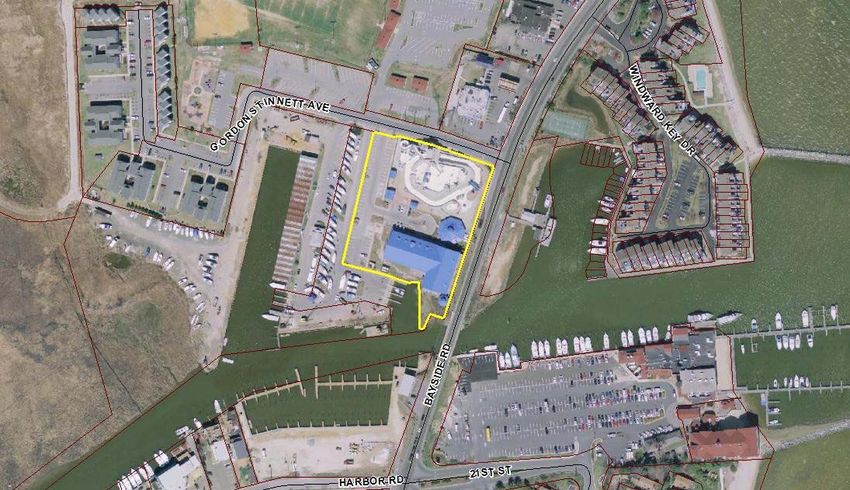
FY 2020 Annual Program

                                                PROPOSED UNBUDGETED COUNTY PROJECTS FOR ACQUISITION

                                                                                                                   SOURCE OF FUNDS FOR
                       PROJECT NAME                                 ACREAGE                                       ANNUAL PROGRAM ONLY
SPONSOR             PROJECT DESCRIPTION                                                                                    ($)
                                                                                                                           LOCAL         STATE
                                                     EXISTING       ULTIMATE      PROJECT                                                        OTHER
                                                                                               TOTAL       LOCAL           SHARE         SHARE
                                                                                                                                                 GRANTS
                                                                                                                            POS           POS

CALVERT     A-1 CANOE AND KAYAK LAUNCH SITES             6               8            2        150,000      75,000          75,000
CALVERT     A-2 FLAG PONDS NATURE PARK ADDITION         560             630          70        1,400,000      0            1,400,000
CALVERT     A-3 PATUXENT WATERFRONT PARK                 0              60           60        2,000,000   1,000,000       1,000,000
            A-4 WAR OF 1812 STAR-SPANGLED BANNER
CALVERT                                                  0              32           32        400,000     100,000         100,000               200,000
            TRAIL
                                                                        Not          Not
CALVERT     A-5 PARKERS CREEK WATERSHED                3000
                                                                     identified   identified
CALVERT     A-6 HUNTINGTOWN TOWN CENTER PARK             0               6            6        250,000     125,000         125,000
CALVERT     A-7 HALLOWING POINT PARK                    81              124          40        600,000     300,000         300,000
CALVERT     A-8 HUNTINGTOWN DISTRICT PARK                0              100          100       2,000,000   1,000,000       1,000,000
CALVERT     A-9 NORTHEAST SECTOR PARK                    0              100          100       2,000,000   1,000,000       1,000,000
CALVERT     A-10 ST. LEONARD DISTRICT PARK               0              100          100       2,000,000   1,000,000       1,000,000
CALVERT     A-11 DUNKIRK COMMUNITY CENTER                0               1            1        1,000,000   500,000         500,000
CALVERT     A-16 CALVERT MARINE MUSEUM ADDITION         10             11.1          1.1       750,000        0            150,000               600,000
CALVERT     A-17 BISCOE GRAY HERITAGE FARM              206             212          6.2       300,000     250,000                                50,000
            A-18 BALTIMORE & DRUM POINT RAILROAD
CALVERT                                                 0.6             210         209±
            TRAIL
                                                                        Not          Not
CALVERT     A-19 PARKS WITH WATER ACCESS               1000+
                                                                     identified   identified
                                                                        Not          Not
CALVERT     A-21 SHARED USED TRAILS                      4
                                                                     identified   identified
            A-22 NATURAL RESOURCES EXPANDED                             Not
CALVERT                                                1500+                        200+
            PROTECTION                                               identified

CALVERT     A-28 UPPER HELLEN CREEK WATERSHED            0             200+         200+
  Highlight indicates new project for the FY 2020 Annual Program.

                                                                     Page 4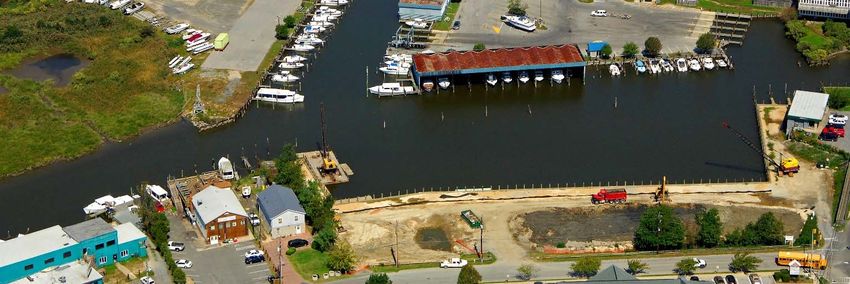
PROJECTS REQUESTED BY MUNICIPALITIES FOR ACQUISITION

                                                                                                                         SOURCE OF FUNDS FOR
                                                                                                                        ANNUAL PROGRAM ONLY
                                                                          ACREAGE
                        PROJECT NAME                                                                                             ($)
SPONSOR
                     PROJECT DESCRIPTION                                                                                          LOCAL      STATE
                                                                                                                                                     OTHER
                                                           EXISTING       ULTIMATE         PROJECT       TOTAL       LOCAL        SHARE      SHARE
                                                                                                                                                     GRANTS
                                                                                                                                    POS       POS
                                                                                               Not
CALVERT    A-12 CHESAPEAKE RAILROAD RIGHT-OF-WAY             .5 mile        7.7 miles
                                                                                            identified
           A-13 NORTH BEACH 2ND & GREENWOOD
CALVERT                                                        0              0.125           0.125      120,000
           POCKET PARK
CALVERT    A-14 NORTH BEACH TOWN PARK                         1.45            1.75+            .30       250,000                 250,000
           A-15 NORTH BEACH NATURE TRAIL (A & B)
CALVERT                                                       1.5            18.215           19.71       75,000      75,000
           SYSTEM
CALVERT    A-20 NORTH BEACH COMMUNITY GARDEN                   0                1               1         50,000      25,000      25,000
                                                                                               Not
CALVERT    A-23 OLD BAYSIDE ROAD TRAIL                         0          Not identified
                                                                                            identified
           A-25 NORTH BEACH CANOE AND KAYAK                                                    Not
CALVERT                                                        0                2
           LAUNCH                                                                           identified
  Highlight indicates new project for the FY 2020 Annual Program.

                                                                       FY 2020 Annual Program
                                                     APPROVED BUDGETED COUNTY PROJECTS FOR DEVELOPMENT

                                 NAME OF RECREATION AREA                                                                    SOURCE OF FUNDS
                                   TYPE OF DEVELOPMENT                                     ACREAGE                    (FOR ANNUAL PROGRAM ONLY)
SPONSOR                                                                                                                            $
                                                                                                                                   LOCAL     STATE
                                                                                           PROJECT       TOTAL       LOCAL         SHARE     SHARE   OTHER
                                                                                                                                     POS       POS   GRANTS
CALVERT    D-2 HALLOWING POINT DISTRICT PARK (Acreage, County owns 82 & leases 20)         102 (82+20)   184,700      184,700
CALVERT    D-3 DUNKIRK DISTRICT PARK                                                           81        1,281,180   1,281,180
CALVERT    D-4 COVE POINT DISTRICT PARK                                                        267       100,600     100,600
CALVERT    D-5 SOLOMONS TOWN CENTER PARK                                                       20        128,800     128,800
CALVERT    D-6 FUTURE PARK IN LUSBY                                                            179       4,100,000   4,100,000
CALVERT    D-8 BISCOE GRAY HERITAGE FARM                                                       206       195,000      67,000                         128,000
CALVERT    D-11 CHESAPEAKE HILLS GOLF COURSE                                                   149       3,546,189   3,546,189
CALVERT    D-14 SOLOMONS BOAT RAMP                                                             4.5       1,002,700    60,000
CALVERT    D-15 KINGS LANDING PARK                                                             260       128,200     128,200
CALVERT    D-16 BATTLE CREEK CYPRESS SWAMP NATURE CENTER                                       100       357,800     357,800

                                                                            Page 5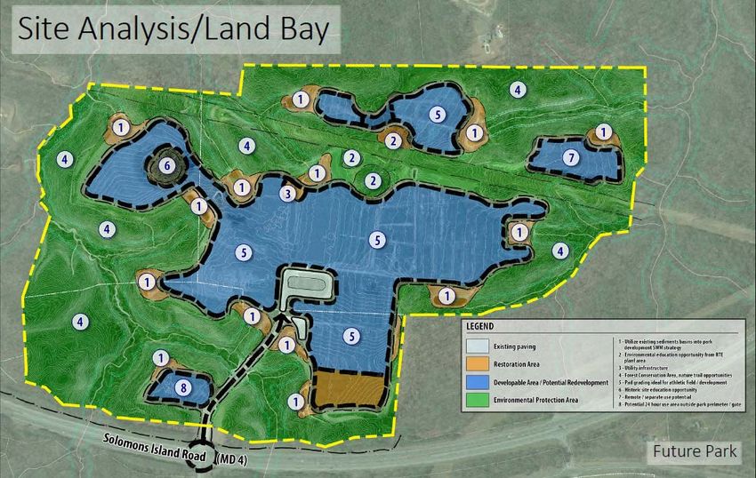
CALVERT    D-18 WARD FARM RECREATION AND NATURE PARK                                209       7,154,577    1,500,000             5,654,577
CALVERT    D-23 FLAG PONDS NATURE PARK                                              1.5        145,000     120,000                25,000
CALVERT    D-30 GATEWOOD PRESERVE                                                  48.35       100,000     100,000
  Highlight indicates new project for the FY 2020 Annual Program.

                                                 PROPOSED UNBUDGETED COUNTY PROJECTS FOR DEVELOPMENT

CALVERT    D-1 KING MEMORIAL PARK                                                    7

CALVERT    D-2 HALLOWING POINT DISTRICT PARK                                        102       2,120,600    1,813,600   307,000
CALVERT    D-3 DUNKIRK DISTRICT PARK                                                81        2,742,000    2,742,000
CALVERT    D-4 COVE POINT DISTRICT PARK                                             267        750,000     750,000
CALVERT    D-5 SOLOMONS TOWN CENTER PARK                                            20
CALVERT    D-7 HARRIET E. BROWN COMMUNITY CENTER (permanent location)               27        8,082,000    8,082,000

CALVERT    D-8 BISCOE GRAY HERITAGE FARM                                            206                                          100,000
                                                                                               300,000     200,000
CALVERT    D-9 BREEZY POINT BEACH PARK AND CAMPGROUND                               13

CALVERT    D-10 B CHESAPEAKE BEACH RAILWAY TRAIL                                    Not
                                                                                 identified
CALVERT    D-11 CHESAPEAKE HILLS GOLF COURSE                                        149       1,199,000    1,199,000
           D-12 BALTIMORE & DRUM POINT RAILROAD TRAIL (PRINCE FREDERICK
CALVERT                                                                             11
           PORTION)
CALVERT    D-13 NORTHEAST COMMUNITY CENTER                                           3
CALVERT    D-15 KINGS LANDING PARK                                                  260        335,000     310,000                25,000
CALVERT    D-16 BATTLE CREEK CYPRESS SWAMP NATURE CENTER                            100        530,000     530,000
CALVERT    D-18 WARD FARM RECREATION AND NATURE PARK                                209       10,000,000   5,000,000             5,000,000
                                                                                    Not
CALVERT    D-22 SHARED USE, NATURAL SURFACE TRAILS COUNTY-WIDE
                                                                                 identified
CALVERT    D-23 FLAG PONDS NATURE PARK                                              560        140,000     115,000                25,000
                                                                                    Not
CALVERT    D-27 WATER ACCESS-BOATING, FISHING, AND CRABBING
                                                                                 identified
CALVERT    D-29 MAIN STREET GREENSPACE
CALVERT    D-30 GATEWOOD PRESERVE                                                   48         50,000                  50,000

CALVERT    D-31 UPPER HELLEN CREEK WATERSHED                                       200+
CALVERT    D-32 KING CALVERT RURAL LEGACY                                           65
  Highlight indicates new project for the FY 2020 Annual Program.

                                                                        Page 6
PROJECTS REQUESTED BY MUNICIPALITIES FOR DEVELOPMENT

                                                                                                                SOURCE OF FUNDS
                                                                             ACREAGE                      (FOR ANNUAL PROGRAM ONLY)
                                 NAME OF RECREATION AREA                                                               $
SPONSOR                            TYPE OF DEVELOPMENT                                                                 LOCAL     STATE
                                                                             PROJECT       TOTAL         LOCAL         SHARE     SHARE           OTHER
                                                                                                                         POS       POS           GRANTS

CALVERT    D-10 A FISHING CREEK PARK AND CHESAPEAKE BEACH RAILWAY TRAIL          104       1,900,000    950,000*                                 950,000

CALVERT    D-19 WETLANDS WILDLIFE OVERLOOK PARK                                 18±

CALVERT    D-20 NORTH BEACH 2ND AND GREENWOOD POCKET PARK                       0.125

CALVERT    D-21 SUNRISE GARDEN                                                  0.70
           D-24 OLD BAYSIDE ROAD TRAIL
CALVERT    PHASE I                                                               0.86      412,500
           PHASE II                                                               2        825,000
                                                                                 Not
CALVERT    D-26 NORTH BEACH CANOE AND KAYAK LAUNCH
                                                                              identified
                                                                                 Not
CALVERT    D-33 CHESAPEAKE BEACH PUBLIC BOAT RAMPS
                                                                              identified
                                                                                 Not
CALVERT    D-34 CHESAPEAKE BEACH SENIOR PLAYGROUNDS
                                                                              identified
  Highlight indicates new project for the FY 2020 Annual Program.

                                                     FY 2020 ACQUISITION PROJECTS
  A-1 Canoe and Kayak Launch Sites
  The County is actively looking for additional public launch sites for canoes, kayaks, and other hand carried boats along the Chesapeake Bay,
  Patuxent River and County creeks. This was one of the goals specifically identified in the Calvert County Land Preservation, Parks and
  Recreation Plan. Each site will be designed to provide parking space for a limited number of cars and a launching area. These types of
  small craft can launch from sites on the Patuxent River at Kings Landing Park, Nan’s Cove, and Jefferson Patterson Park and Museum.
  Small craft can launch onto the Chesapeake Bay from Breezy Point Beach Park, Bay Front Park in the Town of Chesapeake Beach, and at
  the beach in the Town of North Beach. In addition, canoes and kayaks can launch at public boat ramps at Solomons, Hallowing Point, and
  Chesapeake Beach.

                                                                    Page 7
A-2 Flag Ponds Nature Park Addition
This property, which contains approximately 70 acres, is the single remaining parcel to fulfill the preservation goal of the park which
now contains 560 acres of upland hardwood, swamp, marsh and beach habitats. The acquisition of the Wright property could maintain
the natural visual integrity along MD 2/4 at the park’s entrance. It also provides opportunity for additional trails.

A-3 Patuxent Waterfront Park
Public access to the Patuxent River is limited to Kings Landing Park and Solomons. Jefferson Patterson Park and Museum provides
views of the river but very limited access. In addition to one or more small canoe launching sites, a riverfront park could combine water
access and active recreational facilities with historical, cultural and/or natural features.

A-4 War of 1812 Star-Spangled Banner Trail
This trail would provide access to important War of 1812 sites in the County as well as connect several existing public recreational sites,
including Flag Ponds Nature Park, Cove Point Park, Calvert Cliffs State Park, Annmarie Garden and Calvert Marine Museum. The
project includes acquisition of a site near or at the location of the old St. Leonard Town peninsula where, during the summer of 1814,
two Jeffersonian gunboats serving in Commodore Joshua Barney’s Chesapeake flotilla were scuttled in St. Leonard Creek.

A-5 Parkers Creek Watershed
The project to acquire and protect this unique watershed has been the result of the sustained and ongoing efforts of a public-private
partnership including the American Chestnut Land Trust, the Maryland Department of Natural Resources, the Nature Conservancy,
Calvert County and private property owners. Over 4,000 acres (more than 50% of the land area of the watershed) have been preserved
through actions taken by these partners. Three-quarters of the preserved land is available for public access and includes 19 miles of
hiking trails.

A-6 Huntingtown Town Center Park
A Town Center park, called for in the Huntingtown Master Plan, would provide a playground in addition to a lake, trail system, tennis
courts and an all-purpose playing field.

A-7 Hallowing Point Park
The purchase of property will add 40 acres to an existing 81-acre district park and enable the County to meet a strong demand for
additional athletic fields. Property has also been identified to re-route the park exit at busy times to relieve traffic on Route 231. Funding
has only been budgeted for the acquisition of land to re-route the park exit.

                                                                 Page 8
A-8 Huntingtown District Park
The County is actively seeking property in the vicinity of Huntingtown to build a park that will be similar to the County’s existing parks
at Dunkirk, Hallowing Point and Cove Point. Proposed facilities will include ballfields, picnic shelters, playgrounds, tennis and
basketball courts, hiking trails, restroom and concession facilities, maintenance areas, and other facilities as the property will allow.

A-9 Northeast Sector Park
The County is seeking property in the vicinity of North Beach and Chesapeake Beach to build a park that will include ballfields, picnic
shelters, playgrounds, tennis and basketball courts, hiking trails, restroom and concession facilities, maintenance areas, and other
facilities as the property will allow.

A-10 St. Leonard District Park
The County is actively seeking property in the vicinity of St. Leonard to build a park that will be similar to the County’s existing parks
at Dunkirk, Hallowing Point and Cove Point. Proposed facilities will include ballfields, picnic shelters, playgrounds, tennis and
basketball courts, hiking trails, restroom and concession facilities, maintenance areas, and other facilities as the property will allow.

A-11 Dunkirk Community Center
A community center similar to the Dowell House in St. Leonard and Phillips House in Prince Frederick is needed for community meetings
and activities in Dunkirk.

A-12 Chesapeake Beach Railroad Right-of-Way
The Chesapeake Beach Railroad Right-of-Way has the potential of becoming a pedestrian/bicycle/horseback riding trail that would provide
recreation to area residents and promote tourism. The total length of the corridor is approximately 7.7 miles. The off-road portion of the
right-of-way (approximately 3.4 miles) involves 18 separate parcels. In May, 1998, the County acquired a 104-acre tract that includes a
portion of the right-of-way through a combination of Bay Access funds, Critical Area mitigation funds and local side POS funds. The Town
of Chesapeake Beach has completed the first segment of the Chesapeake Beach Railway Trail and may in the future extend it further
along the old railway right-of-way to include a nature trail to the back of Richfield Station creating a walking loop. The nature trail will
be left relatively undisturbed and unimproved. The County would be responsible for land acquisition and development outside the
Chesapeake Beach town boundary.

A-13 North Beach 2nd & Greenwood Pocket Park
The Town of North Beach seeks to acquire and develop a 5,898-square foot corner lot adjacent to the San Francisco community for a
play area for children. The development plan would include such amenities as age appropriate playground equipment, water fountain,
and park benches. Program Open Space funds will be requested to assist with the acquisition and development of the park.

                                                                Page 9
A-14 North Beach Town Park
North Beach is seeking additional land for a Town Park, either adjacent to Callis Memorial Park or in a centralized location within town.
The park would include benches, chairs, chess/checker tables and other passive recreational amenities.

A-15 North Beach Nature Trail (A & B) System
Section A plan for the Trail is to extend the observation area of the overlook to the Burnt Oaks community by connecting the overlook and
Frederick Avenue through a recently acquired parcel of land. Section B plan is to have a Trail System from North Beach to Rose Haven in
Anne Arundel County. The first part of Section B would be pedestrian biker pathway in North Beach beginning at 9th Street and Bay Avenue
and extending northerly for 0.4 mile to the Anne Arundel County line. This part would include a segment adjacent to the wetlands on the
15-acre Walton Parcel recently acquired by the Town. The continuation of the trail would be an extension of the in-town trail from the
Town line to Rose Haven. This part beyond the North Beach line in Anne Arundel County is in the planning stages and will require extensive
coordination with the Rose Haven, Holland Point Citizen Association, Anne Arundel County, and Maryland State Highway Administration
representatives.

A-16 Calvert Marine Museum Addition
The Calvert Marine Museum established the goal of owning all of the property between the museum and the Beacon Marina. At this
point, only this property remains in private hands and is completely surrounded by museum property. Because of its contiguous
waterfront, it is a critical component of the museum’s long range plans. This project would add 1.10 acres of waterfront land and a pier
to the museum campus. The additional land will allow museum to add vital waterfront development such as installing a marine railway
for use by the historic bugeye, Wm. B. Tennison and the skipjack, Dee of St. Mary’s, extending the boardwalk along the waterfront, and
increasing traditional water-based activities. Because the water is deeper in front of this property and the museum-owned property to
the east, the museum would be able to invite larger vessels to the museum and expand its role as a host to visiting vessels. It would also
enable the museum to create an open greenspace from Lore Road to the water to be used for museum events. This is reflected in the
2018 site master plan.

A-17 Biscoe Gray Heritage Farm
In order to provide 24 hour on-site presence on the Biscoe Gray Heritage Farm to ensure protection of livestock, a residence will be
required. One option is to renovate the George Rice house. Other options would be to purchase adjacent properties, such as the original
Gray family residence, a barn and outbuildings. This facility could also provide security to Gatewood Preserve.

A-18 Baltimore & Drum Point Railroad Trail
The path of the Baltimore & Drum Point Railroad runs the entire length of Calvert County, from Owings to Drum Point. Most of the
railroad’s 34 miles is still visible. The challenge is that the company went defunct over a century ago and the right-of-way is not owned
by a single entity. This project is to acquire portions of the Baltimore & Drum Point Railroad, with a special focus on the portion that

                                                              Page 10
runs through Prince Frederick, and develop it as a pedestrian/bicycle trail. Portions of the B&DPRR Trail could be used for the Star-
Spangled Banner Trail (Project A-4).
A-19 Parks with Water Access
Public access to the Chesapeake Bay, Patuxent River and other water bodies within Calvert County is limited to beaches and parks in
the Towns of North Beach and Chesapeake Beach, Breezy Point Beach Park, Flag Ponds Nature Park, and Calvert Cliffs State Park.
The County is seeking new sites to provide a range of public access opportunities: scenic views of the water, boat and fishing access,
and beach combing opportunities, in addition to making improvements to existing facilities to increase public access to water resources.
A-20 North Beach Community Garden
The Town of North Beach is seeking additional land for a community garden. The Town would like to provide a community garden for
those who do not have access to gardening or for anyone with an interest in community gardening. A shared garden can provide a healthy
outdoor recreation for all ages, promote a sense of community, and provide healthy food.
A-21 Shared Use Trails
The County is actively looking for public routes for a network of shared use trails. These trails could be either natural surface or paved, and
would be designed to accommodate a mix of hikers, bikers, and/or equestrians.
A-22 Natural Resources Expanded Protection
Acquisition of lands to support the conservation and stewardship of our natural heritage would also expand the capacity to offer compatible
outdoor recreation opportunities at existing county owned and managed facilities. Areas of special interest include properties adjacent to
Battle Creek Cypress Swamp, Kings Landing Park, and Ward Farm Recreation and Nature Park. In FY 2019, the County acquired Gatewood
Preserve (A-27 in the FY2019 Program Open Space Plan). Other acquisitions are identified in A-2, Flag Ponds Nature Park, A-17, Biscoe
Gray Heritage Farm, and A-28, Upper Hellen Creek.
A-23 Old Bayside Road Trail
A bike path and pedestrian walkway/sidewalk from Beach Elementary along the county maintained Old Bayside Road. The first segment
is anticipated to go along the north side of the road approximately 1,500 linear feet from the school to just south of “E” Street and across
from “F” Street with a long term goal of extending the trail another 3,500 +/- linear feet. This trail would access Calvert County’s
Fishing Creek Park. This project is seen as a trail extension possibility for the school and south part of town to loop back into the county
park and ultimately to the existing Railway Trail.
A-24 Calvert County Land Preservation, Parks and Recreation Plan
The State of Maryland requires local governing bodies to prepare a local land preservation and recreation plan (LPPRP) under the Maryland
Natural Resources Code, Title 5 Forest and Parks. The State is requiring the next Plan to be more detailed and statistically based. The Plan is
Page 11to include a survey on the use of county parks and recreation facilities and programs and a level of service analysis that must include a
Proximity Analysis and a Park Equity Analysis. The updated plan is nearing completion and is expected to be adopted in the spring of 2018.
The next plan will be due in 2022.
A-25 North Beach Canoe and Kayak Launch Sites
North Beach is actively looking for at least two public launch sites for canoes, kayaks, and other hand carried boats. Each site may be
designed to provide parking space for a limited number of cars. Small craft can launch onto the Chesapeake Bay from the beach in the Town
of North Beach, but a designated launch site is preferred so as not to interfere with designated and netted swimming areas.
A-28 Upper Hellen Creek Watershed
The acquisition of the undeveloped forests of the Upper Hellen Creek Watershed in Lusby, MD have been identified as a priority to
develop a natural trail system and associated facilities as the property will allow. This area is adjacent to property owned by Calvert
County currently in the master planning process.
FY 2020 DEVELOPMENT PROJECTS
D-1 King Memorial Park
A seven-acre site in the center of Prince Frederick Town Center was donated to the County by Mr. Boyd King in July, 1993. The property
is located directly adjacent to the Courthouse and includes a portion of the former Baltimore & Drum Point railroad right-of-way that is
proposed as an in-town trail. The park master plan includes hiking trails, a pavilion, a playground, and a formal garden immediately
across from Linden, a historic house acquired by the County for public use through the use of POS funds. Proposed POS funds would
be used to make improvements to the park.
D-2 Hallowing Point District Park
Hallowing Point Park is one of three district parks in the County. The County is in the process of implementing the Hallowing Point
Park master plan for the build-out of the park. In FY 2015 construction was completed on a new playground and associated parking,
and on parking lots to serve fields 3, 5 and 6. In FY 2017 parking and street lights were installed. In FY 2019, the planning began for
the replacement of the restroom/snack stand complex. This project is slated to begin construction in FY 2020. There are also plans to
update the aging master plan which would include the parking areas along the west side of the park incorporating any property acquired.
D-3 Dunkirk District Park
Dunkirk District Park is one of three district parks in the county. The County is in the process of implementing the Dunkirk District Park
Master Plan for the build-out of the park. In FY 2014, field lighting was installed on Field 6. In FY 2016, the County began preparation
of construction drawings for new tennis courts. This however was budget delayed. In FY 2020, the tennis court and pickleball court
project has been revived. Additional plans for a replacement playground and splash pad are budgeted for FY 2021.
Page 12D-4 Cove Point District Park
Cove Point District Park is one of three district parks in the county. Funding will be needed to implement the master plan for the build-out
of the park. In FY 2013, the tennis courts were renovated. In FY 2019, repairs were made to the very popular Cove Point Pool, however
more are needed. In FY 2018, it was determined to update the master plan to Cove Point District Park. This master plan project began in FY
2019 with scheduled adoption in January 2020. Future plans will be determined based on the master plan results.
D-5 Solomons Town Center Park
Solomons Town Center Park was purchased from the Annmarie Garden Board of Trustees in FY 2004. This 20-acre parcel provides
active recreation for residents in the southern end of the county. The park opened in spring 2012 and includes ballfields, a playground,
two shelters, and a restroom facility. The playground and shelters were funded by a state Community Parks and Playgrounds grant.
Field lighting was installed in FY 2014. The installation of field irrigation was completed FY 2019. Future plans include formalizing a
trail to water access which would be an area for a small kayak / paddleboard launch. In addition, there is a desire for restroom upgrades
so at least a portion would not have to be winterized.
D-6 Future Park in Lusby
In FY 2018 the County acquired through donation, 100 acres in Lusby. This combined with 79 acres already owned by Calvert County is
the location of a future regional park. In FY 2018, it was determined to create a master plan for the newly acquired 179 acres off Cove Point
Road west of Route 4. This regional master plan project began in FY 2019 with scheduled adoption in January 2020.
D-7 Harriet E. Brown Community Center (Permanent Location)
A recreation center is needed to serve central Calvert County. On March 1, 2016, the County dedicated the Harriet E. Brown Community
Center in Prince Frederick. The County purchased and renovated the former Southern Maryland Electric Cooperative office building to
serve as an interim community center until the permanent center is built. This facility provides meeting and activity rooms for recreation
programs and public use. It also houses Parks and Recreation’s Central Area office and Therapeutic Recreation Services office. In 2017
the county acquired a property on Fairgrounds Road in Prince Frederick to serve as the permanent site for the Harriet Elizabeth Brown
Community Center. The project area consists of approximately 22 acres including five parcels of property in a location that facilitates
walkable access from several large residential areas. Master planning and design are in the Capital Improvement Plan out years.
D-8 Biscoe Gray Heritage Farm
Rural Legacy funds were used to acquire the Biscoe Gray property in 2002. This 206-acre site is part of a 1,500 acre greenbelt along
Battle Creek and includes farm fields and barns representing Calvert’s longstanding farming tradition. In 2010 a master plan was adopted
for the 196-acre portion of the property between the county road and Battle Creek. Biscoe Gray Heritage Farm is to be a “living
laboratory to explore, understand, and experience Calvert County Agricultural practices and lifeways throughout its history….” Recent
improvements include stabilization of the George E. Rice house and rehabilitation of the homestead’s outbuildings; partial completion
of the entry drive; development of interpretive signs and brochures; and installation of picnic tables and trail benches. Improvements to
Page 13the natural surface trails, development of the Battle Creek boardwalk, and construction of barns and other farm buildings are required
to complete the master plan. With the acquisition of the Gatewood Preserve in 2019, an evaluation of the development of Biscoe Gray
Heritage Farm will be re-evaluated.
D-9 Breezy Point Beach Park and Campground
Breezy Point Park is approximately 13 acres in size and includes 2,000 feet of Bayfront beach with access to Plum Point Creek. In
addition to the wide beach area, the property includes a fishing pier, bathhouse, 100 trailer sites, playground, volleyball court(s),
snack/concession stand, and large shaded picnic area. Most of the planned major improvement projects have been completed. However,
additional funding may be required in future years. In FY 2015, a new playground was installed in the campground. Future projects
include, protective breakwaters and beach restoration, drainage improvements, construction of a new office, replacement/extension of
the fishing pier, and the replacement of the sea wall in campground.
D-10 a Fishing Creek Park and the Chesapeake Beach Railway Trail - Chesapeake Beach
Purchased through the joint efforts of the State and Calvert County, Fishing Creek Park contains 104 acres, which includes approximately
1,800 feet of the Chesapeake Beach Railroad. This property presents an opportunity for the public to experience a unique hiking trail that
combines the cultural heritage of the area with the natural beauty of Fishing Creek and adjoining tidal marsh. Additional opportunities exist
to establish a public canoe launch site and to assist Beach Elementary School to enhance their environmental study area. In 2005, the Town
of Chesapeake Beach was awarded a $1.6 million T21 grant to develop a portion of the right-of-way that will connect two existing residential
subdivisions to the center of town. The Town of Chesapeake Beach has completed the first segment of the Chesapeake Beach Railway
Trail connecting the residential subdivisions of Richfield Station and Bayview Hills to the center of Town and allowing access to the
natural beauty of Fishing Creek and the surrounding tidal marsh.
D-10 b Chesapeake Beach Railway Trail – Calvert County
This County project would be a continuation of the railway trail developed by the Town of Chesapeake Beach. See details in D-10 a above
and A-12 in the acquisition section.
D-11 Chesapeake Hills Golf Course
The County took ownership of the 149-acre Chesapeake Hills Golf Course in Fall 2008 ($3,019,356 County funds). Several
improvements were undertaken in FY 2010 including rehabilitation of the clubhouse exterior, and improvements to the golf course. The
County is in the process of implementing the master plan for the golf course. Construction of a new maintenance facility was completed
in FY 2012. In FY 2014 the installation of a pump station and new golf course irrigation project was completed. In FY 2016, the hole
#2 green was renovated. In FY 2017, the course bunkers were renovated. In FY2018 and FY2019 all fairways have be sprigged with
Bermuda grass. In FY 2019, the old clubhouse building was demolished. Future improvements include renovation of tees, renovation
of the driving range, course drainage improvements, and construction of a new clubhouse. Funding for building a new clubhouse is
scheduled for FY 2020.
Page 14D-12 Baltimore & Drum Point Railroad Trail
The County government owns the portion of the Baltimore & Drum Point Railroad that crosses King Memorial Park in Prince Frederick
(approximately 525 linear feet). As other portions of the railroad bed in Prince Frederick are acquired, develop these as a
pedestrian/bicycle trail from north of Calvert Memorial Hospital, behind the Fox Run Shopping Center, through the woods along Armory
Road, across Main Street, to King Memorial Park.
D-13 Northeast Community Center
Northeast Community Center, located in the Town of Chesapeake Beach, is designed to serve the entire Northeast Sector of the county.
Numerous recreational programs are conducted at the center and it is heavily used by the community for community events and private
events and meetings. In FY 2012, the center’s gymnasium floor was replaced. In FY 2016, the facility metal roof was replaced. The
County is looking at options to replace the boardwalk out front and around the community center. There is also major bridge construction
happening out in front of the community center on the main road that has caused some issues with traffic and entry to the facility which
we will be able to look at when they are complete.
D-14 Solomons Boat Ramp
The renovation of Solomons Boat Ramp was completed in FY2019, funded through State and Federal waterway funds. The restrooms
need renovation and could be upgraded with energy and water saving devices. In anticipation of a change in operations, a facility for
collecting ramp fees and providing a bait and tackle shop may be required. A kayak concession facility would be a possible addition to
the site. In FY 2020, the parking lot will be patched and re-striped, but will need to be repaved within the next five years.
D-15 Kings Landing Park
Kings Landing Park has a wide range of amenities that have a variety of needs to better serve the public. Tom Wisner Hall is used
throughout the year for meetings, weddings receptions, etc. However, there is no defined parking to support these activities. This
project will provide parking for approximately 100 vehicles. Some outdoor lighting is planned for safety during night-time activities.
This parking must be compatible with the Chesapeake Bay Critical Area and has to be made of pervious materials. Seven cabins remain
from when the park was the summer camp site for the Baltimore YMCA. Grant funds were received in FY 2014 and FY 2016 to
rehabilitate the cabins for overnight camping cabins, classrooms for interpretive programs, and day-use shelters. In FY 2007, POS
funding was used to construct a 150’ by 300’ ring for casual riding and equestrian shows. Associated with the ring was the construction
of a 12’ by 16’ roofed judges’ stand with electric service. Current usage of the ring is low, yet the surrounding area is very popular as
a youth group camping area. Overall, a new management and/or strategic plan is needed; the current plan is from 1990 and has many
actions that are not relevant to the current park.
Page 15D-16 Battle Creek Cypress Swamp Nature Center
The Battle Creek Cypress Swamp Nature Center serves as the headquarters for the Natural Resources Division, as well as a Visitor
Center for the Sanctuary. The visitor reception area was renovated to better serve the public. Additional space is needed to create two
office spaces for nature center staff and volunteers. Storm water management and erosion from the drive and parking are in need of
improvement. The existing interior and exterior exhibits, over 10 years old, need to be replaced and/or renovated to maintain and further
the mission of the Natural Resources Division. The construction and renovations of the new animal display exhibits have been on-
going. New exhibits will entice and educate visitors as well as serve the many school groups that come to the facility. Exterior signage
and trail improvements, including repairs to the boardwalk and development of an ADA compliant trail, will better serve the diverse
audiences visiting the swamp.
D-18 Ward Farm Recreation and Nature Park
In FY 2013, the County purchased 209 acres adjacent to the Dunkirk Town Center to build additional playing fields a shared use natural
trail system and associated facilities, restrooms, concession facilities, maintenance facilities and other facilities as the property will
allow. In FY 2015, a master plan for the development of the property was approved. Since the approval, the County has begun
implementing the park’s master plan. The purchase of the property was made possible through the Calvert County Youth Recreational
Opportunities Fund. This special fund was created by the State Legislature in 2012 and is administered by the Secretary of Maryland
Department of Natural Resources. A portion of the revenue received from gaming in Chesapeake Beach and North Beach is returned
to Calvert County to the purpose of increasing recreational opportunities for youth in the county. In FY 2017, the preparation of
construction drawings for Phase 1 development began which included an entrance road, a multi-purpose field, parking, restroom and
educational shelter. In FY 2019, final site design and permitting on Phase 1 was completed (except educational shelter). In addition
planning has begun on a pier facility, infrastructure (electric), and a roundabout entrance off Ward Road. Construction on Phase 1 will
begin early FY 2020.
D-19 Wetlands Wildlife Overlook Park
The Town of North Beach has acquired two larger parcels on the west side of MD 261(Parcel 2 totals 14.539 acres, Parcel 3 totals 3.676
acres). The Town of North Beach is working with the Army Corps of Engineers to restore the wetlands. Once restored and properly
managed, this resource would provide many benefits; including opportunities for recreation, wildlife observation, photography, flood
control and other benefits derived from a restored and functioning wetlands area.
D-20 2nd & Greenwood Pocket Park
The Town of North Beach seeks to acquire and develop a 5,898-square foot corner lot adjacent to the San Francisco community for a
play area for children. The development plan would include such amenities as age appropriate playground equipment, water fountain,
and park benches. Program Open Space funds will be requested to assist with the acquisition and development of the park.
Page 16D-21 Sunrise Garden
The Town of North Beach developed a 30,000-square foot waterfront parcel (Block 2 Lots 7, 8, 9, 10) as a passive park with a sculpture
garden and other amenities such as a fountain, benches and walkways. The public park provides views of the Chesapeake Bay. Program
Open Space funds were requested to assist in the development of the park.
D-22 Shared Used, Natural Surface Trails County-wide
There is a need for shared use, natural surface trails to accommodate trail running, off-road bicycling, horseback riding, and/or hiking. Trail
plans could be developed at existing facilities, such as Kings Landing Park, Flag Ponds Nature Park, and Ward Farm Recreation and Nature
Park, as well as new locations for a trail connecting Prince Frederick to the Patuxent River.
D-23 Flag Ponds Nature Park
The Educational Building was constructed to provide spaces for environmental education programs. A comprehensive exhibit design
plan and implementation budget would be developed for the construction of interpretive resources of Flag Ponds Nature Park. This plan
would include existing and future facilities, as well as the natural features of the park that can add to the visitor experience. The scope
of the project will include a series of interpretive exhibits on the natural and cultural history of the park, interpretive areas for group
programs and lessons, and a small meeting room for workshops and trainings that are compatible with goals of the park and the Division
of Natural Resources. Construction of a shelter at the beach and wayside stations along the trails would provide additional exhibit and
interpretive spaces, located where the majority of visitors congregate.
D-24 Old Bayside Road Trail
A bike path and pedestrian walkway/sidewalk from Beach Elementary along the county maintained Old Bayside Road. The first segment
is anticipated to go along the north side of the road approximately 1,500 linear feet from the school to just south of “E” Street and across
from “F” Street with a long term goal of extending the trail another ±3,500 linear feet to the town limits at “I” street. This trail would
access Calvert County’s Fishing Creek Park. This project is seen as a trail extension possibility for the school and south part of town to
loop back into the county park and ultimately to the existing Railway Trail. The Town is currently in the design phase of the sidewalk
project, funded 80% by the State of Maryland Safe Routes to School program. The Town seeks to allow safe access from Beach
Elementary School to Bay Front via sidewalks and crosswalks.
D-26 North Beach Canoe and Kayak Launch
There is a need for a canoe and kayak launch in the Town of North Beach that is easily accessible and not in the designated swimming areas.
D-27 Water Access-Boating, Fishing and Crabbing
There is a need for adding, expanding and improving water access throughout the county. This project will pursue improvements for water
access, including kayak/canoe launching, fishing and crabbing through repairs and renovation of existing facilities and installation and
Page 17construction of new structures to increase opportunities for water-based activities and access to the Chesapeake Bay, Patuxent River and its
tributaries.
D-29 Main Street Green Space
In FY 2017, planning began for development of the Main Street Green Space. This portion of existing roadway is being donated to the
county as part of the Maryland State Highway Administration’s (SHA) Main Street Project. SHA will grade the area to the County’s
specifications. SHA is scheduled to complete their portion of the project in FY 2020 which will then allow the County to take over
management. Funds are anticipated in FY 2020 to develop a sidewalk, recreational amenities and connections to the shopping center.
D-30 Gatewood Preserve
Projects include upgrades to the existing pier to improve ADA access and easier launching of kayaks, such as a floating dock,
conversion of the residence into a nature center, with, offices, small classroom and public restrooms. The barns and animal shelters
would be used to house equipment, a maintenance workshop, and possible domestic animals for interpretive programs. A
management plan for the property and buildings on site will guide future planning for development of trails and public water access
facility.
D-31 Upper Hellen Creek Watershed
The undeveloped forests of the Upper Hellen Creek Watershed adjoining project D-6, Future Park in Lusby, have been identified as a
priority acquisition to develop a natural trail system and associated facilities as the property will allow.
D-32 King Calvert Rural Legacy
Acquisition of this property was through the Rural Legacy Program. The wooded parcel abuts the southern border of Ward Farm
Recreation and Nature Park and includes a portion of Hall Creek and its floodplain. Natural surface trails and elevated boardwalks
will provide access for public education and ecological monitoring projects. Efforts to create a nature play space and outdoor
classroom would benefit the local community, schools, and the public.
D-33 Chesapeake Beach Public Boat Ramps
The Town owns six public boat ramps within the Kellam’s Recreational Complex. The Town is in the process of renovating the piers
and is seeking funds from the Department of Natural Resource’s Waterway Improvement fund. The parking lot was repaved in late
FY 2019.
D-34 Chesapeake Beach Senior Playgrounds
The Town of Chesapeake Beach is seeking to include a senior playground concept in multiple areas of the Town allowing for residents
to incorporate additional exercise into their activities. The concept is geared towards seniors, however, the playground could be used by
all citizens.
Page 18Calvert County
FY 2020 Program Open Space
Annual Program
Project Descriptions
Adopted June 25, 2019A-1 Canoe and Kayak Launch Sites
The County is actively looking for additional public launch sites for canoes, kayaks, and other hand carried boats along the Chesapeake
Bay, Patuxent River and County creeks. This is one of the goals specifically identified in the Calvert County Land Preservation, Parks
and Recreation Plan. Each site will be designed to provide parking space for a limited number of cars and a launching area. These
types of small craft can launch from sites on the Patuxent River at Kings Landing Park, Nan’s Cove, and Jefferson Patterson Park and
Museum. Small craft can launch onto the Chesapeake Bay from Breezy Point Beach Park, Bay Front Park in the Town of Chesapeake
Beach, and at the beach in the Town of North Beach. In addition, canoes and kayaks can launch at public boat ramps at Solomons,
Hallowing Point, and Chesapeake Beach. Canoeing and kayaking are low-impact recreational uses, which help promote the State’s
Planning Vision #1 on quality of life and sustainability. (Refer to the last page for a list of the State of Maryland’s Planning Visions.)
2A-2 Flag Ponds Nature Park Addition
The Wright property contains 70 acres (more or less) and adjoins the northeast corner of Flag Ponds Nature Park. This is the last
remaining parcel to fulfill the preservation goal of the park, which now contains 546 acres of upland hardwood, swamp, marsh, and
beach habitats. The acquisition of the Wright property would maintain the natural visual integrity along MD 2/4 at the park’s entrance.
It also provides opportunity for additional trails. This project is consistent with Planning Vision #1, which states “A high quality of
life is achieved through universal stewardship of the land, water, and air resulting in sustainable communities and protection of the
environment.”
Flag Ponds Nature Park
Boundaries are approximate.
3A-3 Patuxent Waterfront Park
Calvert County is nearly surrounded by water but access to the water remains limited, despite substantial acquisitions by both the
County and the State. Waterfront access, therefore, remains a priority. There are several public access sites along the Chesapeake Bay,
but public access to the Patuxent River is limited to Kings Landing Park, Hallowing Point, Nan’s Cove, and Solomons. Jefferson
Patterson Park and Museum provides views of the river but very limited access. In addition to one or more small canoe launching
sites, a riverfront park could combine water access and active recreational facilities with historical, cultural and/or natural features.
Several of the other acquisition projects listed in this report could be accommodated on a waterfront site. Acquisition of a waterfront
site is consistent with Vision #9 “Environmental protection: Land and water resources, including the Chesapeake and Coastal Bays,
are carefully managed to restore and maintain healthy air and water, natural systems, and living resources.”
4A-4 War of 1812 Star -Spangled Banner Trail
During the summer of 1814 two Jeffersonian gunboats serving in Commodore Joshua Barney’s Chesapeake flotilla were scuttled in St.
Leonard Creek. The State of Maryland Department of Natural Resources identified a series of potential areas in which to expand
Maryland’s Greenway Network as early as 1995. One of these potential greenways was designated the Flag Ponds to Solomons Trail.
Part I of this hiking, biking, horseback riding trail system would connect Flag Ponds to Cove Point Park. Ideally, the trail would include
several smaller loops to allow for trips of varying lengths.
Part II would be a bikeway along shoulders on MD 765 to Dowell Road and then split into two trails, one along Dowell Road past
Annmarie Garden and the other along H.G. Trueman and Solomons Island Road to the Calvert Marine Museum. The museum currently
has a display depicting the route of the British up the Patuxent River to Washington D.C. where they burned the Capitol during the War
of 1812. Other artifacts of the period are displayed in the museum.
This entire project would tie in with one of the product development initiatives of the Maryland Office of Tourism Development which
calls for the establishment of a series of trails throughout the state that are relevant to the War of 1812. The Maryland War of 1812
Bicentennial Commission is planning a multi-year cultural tourism and educational initiative. Governor Martin O’Malley established
the Commission on September 8, 2007 by an Executive Order. More information on Maryland’s commemoration of the War of 1812
is available from the Maryland Office of Tourism, www.visitmaryland.org and www.starspangled200.com.
For information on rail trails, explore www.railtrails.org. Creating an 1812 trail is an example of resource conservation and, therefore,
consistent with the State’s Vision #10.
3
1
2
4
1. Old St. Leonard Town
2. St. Leonard Creek
3. Flag Ponds
4. Cove Point Park
5. Solomons
5
5A-5 Parkers Creek Watershed
The project to acquire and protect this unique watershed has been the result of the sustained and ongoing efforts of a public-private partnership
including the American Chestnut Land Trust, the Maryland Department of Natural Resources, the Nature Conservancy, Calvert County and
private property owners. Over 4,000 acres (more than 50% of the land area of the watershed) have been preserved through actions taken by
these partners. Three-quarters of the preserved land is available for public access and includes 19 miles of hiking trails. Preservation of the
watershed is consistent with Planning Vision #1 (stewardship), Vision #9 (resource conservation), and Vision #12 (implementation). In
2014, the Maryland General Assembly recognized the State-owned land in the Parkers Creek watershed as a designated State Wildlands.
Parkers Creek is a tidal stream, navigable by canoe and kayak, which traverses barrier beach, salt marsh, freshwater swamp, and thick forests,
altogether a microcosm of the Chesapeake Bay itself. It is the last such stream still in its natural state on Maryland’s western shore. While
farmland bordered the stream in the 18th-19th centuries, thick forests now frame the marshland, giving the visitor a wilderness vista resembling
that of the 17th century. The creek opens out to a wide beach that forms part of a 1 ¾-mile section of undeveloped scenic shoreline along the
Chesapeake Bay. In addition to the beach, the shoreline includes sections of the Calvert Cliffs which contain some of the most well-known
and significant fossil deposits in the world, offering us a window into our ancient past, 12 to 18 million years ago.
6A-6 Acquisition of Town Center Park - Huntingtown
The Board of County Commissioners approved a master plan for
Huntingtown Town Center in September, 1993. The Master Plan calls
for linking the central gathering area of the town center to an open
space corridor along Cocktown Creek through a series of linear parks.
The largest park - which the Bowen property would become - would
provide a playground in addition to a lake, trail system, tennis courts
and an all-purpose playing field.
The Bowen property is located on the north side of Hunting Creek
Road near the designated central gathering place in the Town Center.
The total property is 5.26 acres but there is a potential to add to the Site
park. The topography of the land would lend itself to the creation of
a man-made lake, which would serve as a focal point in the park.
There would be pedestrian paths connecting the park with the
business area, as well as a trail system.
By providing recreation in an existing Town Center, this project is
consistent with Planning Vision #3 which calls for growth to be
concentrated in existing population and business centers. The project
is consistent with the goal listed in the Calvert County Land
Preservation, Parks, and Recreation Plan of providing a town park in
or near each Town Center.
7A-7 Hallowing Point Park
The purchase of property will add 40 acres to the existing 81-acre Hallowing Point Park and enable the County to meet a strong
demand for additional athletic fields. The property is level and well suited to active recreational use. By adding on to an existing
park and utilizing existing infrastructure, the project will cost less to develop and maintain than a comparable site at a new location.
It will also utilize land more efficiently. Property has also been identified to re-route the park exit at busy times to relieve
traffic on Route 231. For these reasons it is consistent with Planning Vision #3 which calls for growth to be concentrated in
existing population and business centers.
8A-8 Huntingtown District Park
The County is actively seeking property in the vicinity of Huntingtown to build
a park that will be similar to the County’s existing parks at Dunkirk, Hallowing
Point and Cove Point. We are seeking parcels no smaller than 100 acres.
Proposed facilities will include ballfields, picnic shelters, playgrounds, tennis
and basketball courts, hiking trails, restroom and concession facilities,
maintenance areas, and other facilities as the property will allow.
This project is consistent with the Calvert County Land Preservation, Parks, and
Recreation Plan, which calls for a community park that will provide facilities
and space for team sports in or near each of the County’s Town Centers. It is also
consistent with Planning Vision #3, which calls for growth to be concentrated in
existing population and business centers, growth areas adjacent to these centers,
or strategically selected new centers.
9A-9 Northeast Sector Park
The County has identified the need for an additional park near North
Beach/Chesapeake Beach to include ballfields, picnic shelters,
playgrounds, tennis and basketball courts, hiking trails, restroom and
concession facilities, maintenance areas, and other facilities as the property
will allow. The project is consistent with the Calvert County Land
Preservation, Parks, and Recreation Action Plan, which states that each
town center should have an outdoor public facility designed primarily for
active team sports. It is also consistent with the Northeast Sector Plan,
which identifies the need for active recreation sites in the vicinity of the
North Beach and Chesapeake Beach. The provision of recreational facilities
in or near Town Centers helps promote Vision #3 by directing growth to
existing population and business centers.
10A-10 St. Leonard District Park
The County is actively seeking property in the vicinity of St. Leonard to build a park
that will be similar to the County’s existing district parks at Dunkirk, Hallowing Point
and Cove Point. We are seeking parcels no smaller than 100 acres. Proposed facilities
will include ballfields, picnic shelters, playgrounds, tennis and basketball courts,
hiking trails, restroom and concession facilities, maintenance areas, and other
facilities as the property will allow.
This project is consistent with the Calvert County Land Preservation, Parks and
Recreation Plan, which calls for a community park that will provide facilities and
space for team sports in or near each of the County’s Town Centers. It is also
consistent with Planning Vision #3, which calls for growth to be concentrated in
existing population and business centers, growth areas adjacent to these centers, or
strategically selected new centers.
11A-11 Dunkirk Community Center
The County is looking for a small site with an existing building near or
adjacent to Dunkirk Park to use as a community center for area
residents. The property would be similar to the Dowell House property
in St. Leonard and Phillips House in Prince Frederick, and would
provide meeting rooms and space for indoor activities.
This project is consistent with the Calvert County Comprehensive
Plan to provide an indoor community center for each of the Town
Centers.
By providing a centralized community space in the Town Center of
Dunkirk, the project would promote Vision #3 which states that
growth is concentrated in existing population or business centers.
12You can also read