A City of Promenades - Academic Journals | Athens Institute ...
←
→
Page content transcription
If your browser does not render page correctly, please read the page content below
2020-3720-AJA-PLA

 1                             A City of Promenades
 2
 3       Studying old maps showing the transformation of Mexico City can unveil
 4       possible footprints and disappearance of historic facilities and utilities in the
 5       process of urban modernisation. The objective of this exercise is to uncover
 6       the location of old structures of Pre-Hispanic and Colonial Mexico City as a
 7       basis for creating a new footprint of urban memory and identity. “A city of
 8       promenades” proposes the appropriation and use of public space, the recu-
 9       peration of lost cultural and geographic landscapes; it takes the routes and
10       paths, the aqueducts, the roads, the moats, the ramparts, the gates of the his-
11       toric city and its connections to other villages which now conform this great
12       metropolitan area and it revives them with a modern touch, to create a sense
13       of meaningful place, giving the inhabitants the opportunity to experience the
14       changes of a growing city. These paths will serve as detonators of projects
15       and actions which will improve patterns of use and sense of identity, offering
16       landmarks, establishing linear parks as connectors of different scales of ex-
17       isting parks and, through modern design, creating a rediscovered footprint
18       of monuments, landscapes and infrastructures long gone. This proposal is
19       an integral project for the Mexico City Metropolitan Area. It begins at the
20       neighbourhood level and forms part of an urban park system; connecting the
21       surrounding natural landscapes and woodlands, the urban parks, sports
22       clubs, neighbourhood parks, squares, bridges, central reservations, side-
23       walks, tree and flower beds, chapels, rights of way, unused railways, roads,
24       avenues, greenhouses, agricultural trails, cemeteries, brooks and water-
25       ways, ravines, canals, terraces, balconies, cloisters and convent patios, ar-
26       cheological sites and unbuilt urban block cores. The city of paths and
27       strolls, of boulevards, of old roads to haciendas and convents, of dikes,
28       gateways, old custom house gates, water fountains and springs, canals,
29       causeways, watermills and aqueducts is an academic exercise with students
30       and teachers to find a meaningful representation of the layers of history that
31       builds a city and creates identity.
32
33       Keywords: Park system, urban connectors, historic footprints
34
35
36   Introduction
37
38        This teaching-learning exercise has been practiced during two school
39   terms in the Undergraduate Architecture Programme at Universidad Iberoamer-
40   icana, Mexico City. The overall objective of the syllabus is to generate a con-
41   versation between students and their awareness of the open space of cities. The
42   course is Landscape Design Studio, and the syllabus that I have proposed is
43   non-conventional in the sense that it does not concentrate on the technique of
44   design, but rather on the ‘ideas’ and ‘ethos’ behind parks, gardens and urban
45   open space and their contribution to improving the image, resiliency, health,
46   justice and identity of neighbourhoods, especially if they are connected to form
47   a system.

                                                1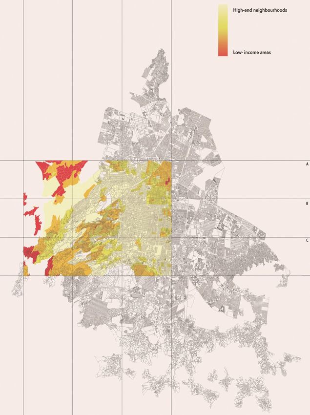
2020-3720-AJA-PLA

 1   Literature Review and Methodology
 2
 3        During my research on the city, as an academic interested in the history of
 4   urban form, I have been building a Timeline for Park Systems that contains the
 5   intentions of using green open space (parks, squares, tree-lined boulevards) as
 6   a planning strategy from the 17th to the 21st Century, when connecting parks
 7   and other forms of green space has become a resiliency and sustainability strat-
 8   egy. I offer a brief synthesis:
 9
10       1660 - Paris and the demolition of its defensive walls transformed into
11       boulevards and tree-lined promenades, during the reign of Louis XIV (Jor-
12       dan, David P., 1995, p. 29) [see Figure 1].
13
14   Figure 1. Paris. Historical Footprint, 1660

15
16   Source: Adapted from GOOGLE EARTH 2019.
17
18       1667 - London and the fire of 1666 meriting its rebuilding with the open-
19       ing of landscaped squares (Morris, A.E.J., 1994, pp. 261-263) [see Figure
20       2].

                                            2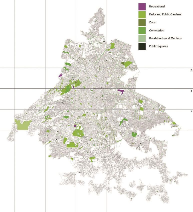
2020-3720-AJA-PLA

 1   Figure 2. London. Historical Footprint, 1667

 2
 3   Source: Adapted from GOOGLE EARTH 2019.
 4
 5       1733 - James Oglethorp builds the city of Savannah, Georgia, (Bacon,
 6       Edmund, 1974, p. 220), based on a grid of cellular units of 12 blocks that
 7       shared a central green square [see Figure 3].
 8
 9   Figure 3. Savannah, Georgia. Historical Footprint, 1733

10
11   Source: Adapted from GOOGLE EARTH 2019.
12
13       1810 - John Nash designs and builds the connection between St. James’
14       Park and Regent’s Park through the layout of the new Regent Street and
15       Portland Place (Bacon, Edmund, 1974, p. 201) [see Figure 4].
16
17

                                           3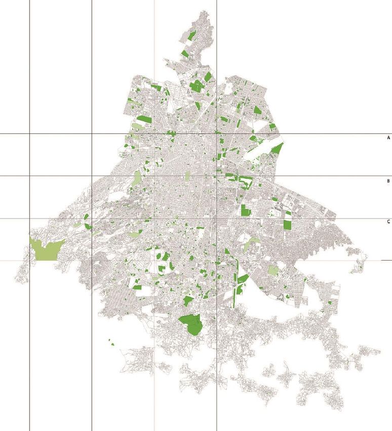
2020-3720-AJA-PLA

 1   Figure 4. Connection between Regents Park and St James Park. Historical
 2   Footprint, 1810

 3
 4   Source: Adapted from GOOGLE EARTH 2019.
 5
 6       1853 - Baron Haussmann begins work for the rennovation of Paris and, to-
 7       gether with Jean-Charles Alphand, the city will be equipped with a series
 8       of parks during the Second Empire (Jordan, David P., 1995, p. 238) [see
 9       Figure 5].
10
11   Figure 5. Paris. Historical Footprint, 1853

12
13   Source: Adapted from GOOGLE EARTH 2019.
14
15       1858 - Ludwig von Förster designs the Vienna Ringstrasse (Morris, A.E.
16       J., 1994, p. 228), including parks and landscaped squares along a broad
17       avenue-promenade [see Figure 6].
18

                                           4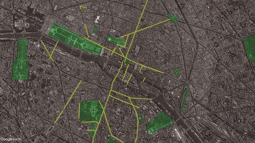
2020-3720-AJA-PLA

 1   Figure 6. Vienna. Historical Footprint, 1858

 2
 3   Source: Adapted from GOOGLE EARTH 2019.
 4
 5       1859 - Ildefonso Cerdà creates the Plan for the Extension of Barcelona,
 6       where parks and gardens are integrated in the urban blocks and are a cru-
 7       cial health feature, (Gruppo “2 C”, 1979, p. 86) [see Figure 7].
 8
 9   Figure 7. Barcelona. Historical Footprint, 1859

10
11   Source: Adapted from GOOGLE EARTH 2019.
12
13       1867 - Jean-Charles Adolphe Alphand publishes Les Promenades de Paris,
14       testimony of his work with Baron Haussmann and beyond, repositioning
15       the importance of parks and promenades (Leclerc, Bénédicte, 1997, p. 29).
16       1878 - Frederick Law Olmsted designs the Emerald Necklace for Boston,
17       Massachusetts (Beveridge, Charles, et.al., 1995, p. 98) [see Figure 8].
18

                                           5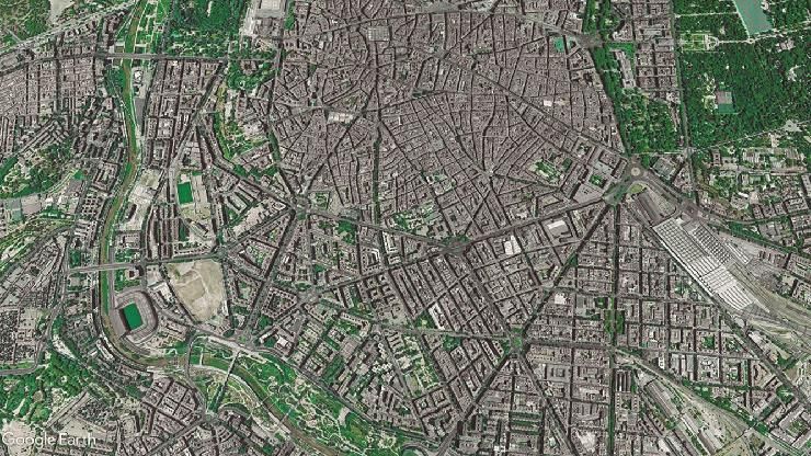
2020-3720-AJA-PLA

 1   Figure 8. Emerald Necklace for Boston. Historical Footprint, 1878

 2
 3   Source: Adapted from GOOGLE EARTH 2019.
 4
 5       1883 - Establishment of the Minneapolis, Minnesota ‘Grand Rounds’ Re-
 6       gional Park System and extensive neighbourhood park distribution every 6
 7       blocks (Tate, Alan, 2004, p. 179) [see Figure 9].
 8
 9   Figure 9. Minneapolis. Historical Footprint, 1883

10
11   Source: Adapted from GOOGLE MAPS 2019.
12
13       1902 - Ebenezer Howard publishes Garden Cities of Tomorrow (Hall, Pe-
14       ter, 1996, p. 87), combining the virtues of country and city to solve the
15       polluted, unjust, industrialized metrópolis [see Figure 10].
16

                                              6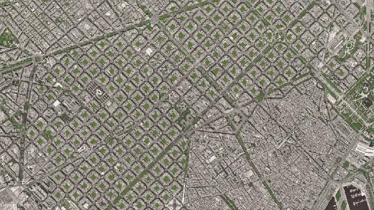
2020-3720-AJA-PLA

 1   Figure 10. Hampstead Garden City. Historical Footprint, 1902

 2
 3   Source: Adapted from GOOGLE EARTH 2019.
 4
 5       1904 - Miguel Ángel de Quevedo establishes greenhouses in Mexico City
 6       to supply plants for parks and boulevards (Eguiarte, Estela, 2004, p. 82)
 7       [see Figure 11].
 8
 9   Figure 11. Mexico City. Historical Footprint, 1904

10
11   Source: Adapted from GOOGLE EARTH 2019.
12
13       1908 - Nicolas Forestier publishes Grandes Villes et Systèmes de Parcs,
14       where he establishes his theory of park systems, and classification of parks
15       according to scale and function (Leclerc, Bénédicte, 1997, p. 20).
16
17       1909 - Daniel H. Burnham publishes the Plan for Chicago, which proposes
18       the expropriation of land to build a park system connected by urban corri-

                                            7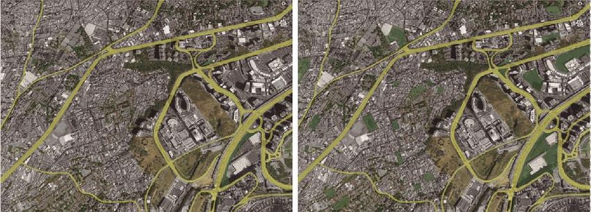
2020-3720-AJA-PLA

 1       dors (Burnham, Daniel H., 2009, p. Moore, Charles, 2009, p. ix) [see Figu-
 2       re 12].
 3
 4   Figure 12. Chicago. Historical Footprint, 1909

 5
 6   Source: Adapted from GOOGLE EARTH 2019.
 7
 8       1912 - Krupp enterprises builds Margarethenhöhe, first garden city in
 9       Germany following the design principles of Raymond Unwin (Hall, Peter,
10       1996, p. 115) [see Figure 13].
11
12   Figure 13. Margarethenhöhe. Historical Footprint, 1912

13
14   Source: Adapted from GOOGLE EARTH 2019.
15
16       1913 - Edwin Lutyens and Herbert Baker design layout for New Delhi, In-
17       dia in the ‘City Beautiful’ tradition, begun by Daniel Burnham in the USA
18       (Hall, Peter, 1996, p. 187) [see Figure 14].

                                           8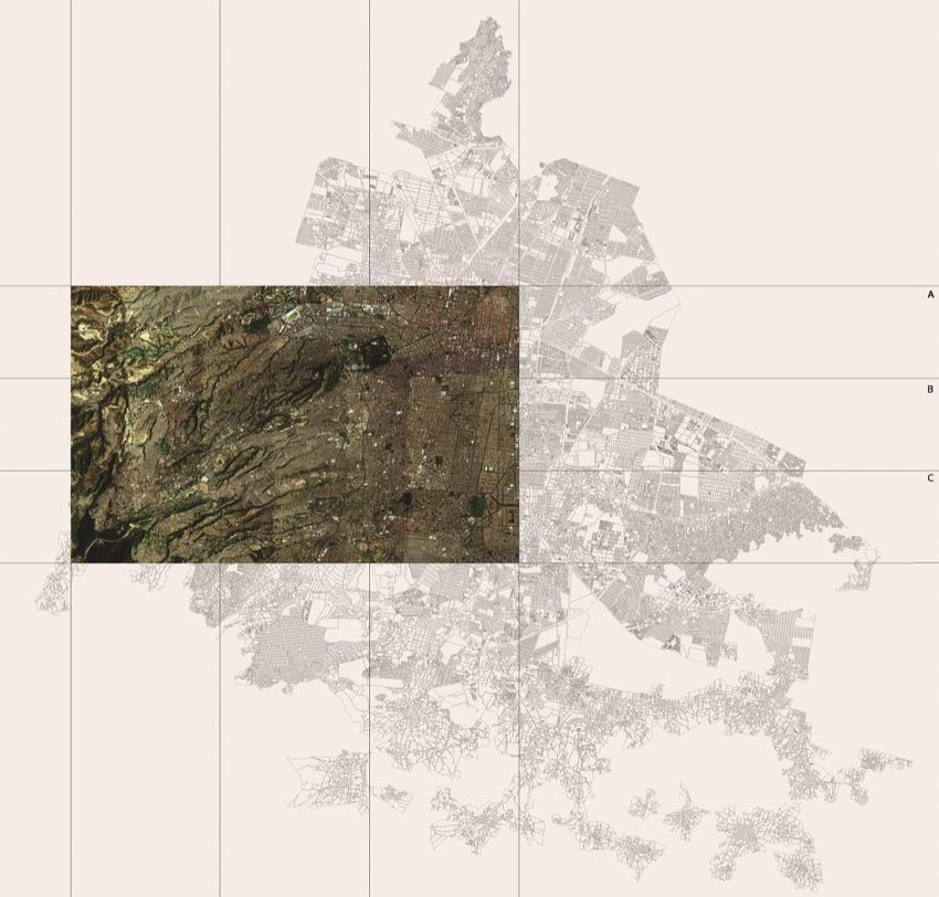
2020-3720-AJA-PLA

 1
 2   Figure 14. New Delhi. Historical Footprint, 1913

 3
 4   Source: Adapted from GOOGLE EARTH 2019.
 5
 6       1923 - Forestier proposes a park system for Paris, linking parks with ave-
 7       nue-promenades (Leclerc, Bénédicte, 1997, p. 38).
 8
 9       1925 - Ernst May in Frankfurt uses Raymond Unwin’s urban design prin-
10       ciples for a new low-income neighbourhood Römerstadt, including a sys-
11       tem of open spaces (Panerai, Philippe; et.al., 2001, pp. 115-119) [see Figu-
12       re 15].
13
14   Figure 15. Römerstadt. Historical Footprint, 1925

15
16   Source: Adapted from GOOGLE EARTH 2019.
17
18       1926 - José Luis Cuevas-Pietrasanta develops the urban design proposal
19       for a new neighbourhood in Mexico City, Colonia Hipódromo Condesa,

                                            9
2020-3720-AJA-PLA

 1       the park and avenue-promenade being the central features (https://es.wiki
 2       pedia.org/wiki/Parque_Mexico ), and covering almost 40% of the land [see
 3       Figure 16].
 4
 5   Figure 16. Mexico City, Colonia Hipódromo Condesa. Historical Footprint,
 6   1926

 7
 8   Source: Adapted from GOOGLE EARTH 2019
 9
10       1927 - The local government in Washington, D.C. bought more than 130
11       Km2 to create a park system of woodlands, ravines and streams, which are
12       currently protected (Hall, Peter, 1996) [see Figure 17].
13
14   Figure 17. Washington, D.C. Historical Footprint, 1927

15
16   Source: Adapted from GOOGLE EARTH 2019.
17

                                          10
2020-3720-AJA-PLA
1 1938 - Holger Blom, Head of the Parks Department in Stockholm, builds
2 the first park system in Europe, along the edge of Lake Mälaren (Turner,
3 Tom, 2005, p. 252) [see Figure 18].
4
5 Figure 18. Stockholm. Historical Footprint, 1938
6
7 Source: Adapted from GOOGLE EARTH 2019.
8
9 1950 - The city of Stuttgart sparks a park system through yearly flower
10 exhibits that encourage the connection between the royal parks and other
11 open areas (Turner, Tom, 2005, p. 252) [see Figure 19].
12
13 Figure 19. Stuttgart. Historical Footprint, 1950
14
15 Source: Adapted from GOOGLE EARTH 2019.
16
17 1951 - Le Corbusier and team carry out the master plan for the new capital
18 city of Chandigarh, integrating a complex park system to the scheme (Boe-
112020-3720-AJA-PLA
1 siger, Willy, London, Thames and Hudson, Ltd., p. 194 and 195) [see Fi-
2 gure 20].
3
4 Figure 20. Chandigarh. Historical Footprint, 1951
5
6 Source: Adapted from GOOGLE EARTH 2019.
7
8 1958 - Creation of the National Trails System Act in the USA, to form,
9 maintain and protect rural and urban trails for all age groups (https://www.
10 nps.gov/subjects/nationaltrailssystem/index.htm).
11 1976 - King Juan Carlos I of Spain entrusts by decree the Turia River
12 causeway to the local authorities in Valencia, to be diverted due to the
13 constant risk of flooding in housing áreas along its route. The original
14 causeway is now a linear park (https://elpais.com/diario/2006/12/15/cva
15 lenciana/1166213896_850215.html) [see Figure 21].
16
17 Figure 21. Turia River. Historical Footprint, 1976
18
19 Source: Adapted from GOOGLE EARTH 2019.
20
122020-3720-AJA-PLA
1 1988 - Development Plan for Barcelona in preparation for the 1992 Olym-
2 pic Games, including an open space system recovering public recreational
3 beach and proposing a series of neighbourhood parks (Turner, Tom, 2005,
4 p. 253) [see Figure 22].
5
6 Figure 22. Barcelona. Historical Footprint, 1988
7
8 Source: Adapted from GOOGLE EARTH 2019.
9
10 2017 - Groundbreaking of Madrid’s Río Manzanares renovation project,
11 creating parks and recreational spaces along its banks [see Figure 23].
12
13 Figure 23. Madrid’s Río Manzanares. Historical Footprint, 2017
14
15 Source: Adapted from GOOGLE EARTH 2019.
16
17 Literature on parks and recreational open space has evolved from the 19th
18 Century to this day. What was called parks and park systems is now ‘boundless
19 space’, a term used by Tom Turner (1996); or ‘green systems’ by Andrés
132020-3720-AJA-PLA
1 Duany and Elizabeth Plater-Zyberk (Farr, Douglas, 2008); or ‘biodiversity cor-
2 ridors’, by Douglas Farr (Farr, 2008); or ‘recreational systems’, by Lester
3 Brown (Brown, 2009); influenced by the more recent environmental and social
4 considerations, which strengthen and diversify the significance and potential of
5 park systems to adapt to a variety of contexts.
6 The examples viewed above are indicative of the different planning strate-
7 gies that they encouraged and upholded. There are clues to be found in the con-
8 struction of a park system theory that could have the benefit of successful his-
9 toric proposals of the past, as well as be complimented with the planning and
10 design tendencies of today. In this sense, academic exercises may prove a valu-
11 able tool in integrating ideas.
12
13
14 Findings/Results
15
16 The teaching experience of this course has drawn a learning curve that dic-
17 tates the scale of exercises that can be administered throughout a term (one
18 semester), in order to achieve the desired results with students. I would like to
19 give testimony to this experience.
20
21 Education as a Promenade
22
23 “Landscapes are defined by paths. When people inhabit a place, they cut
24 across it on clear roads, bodies of water, or swaths of the earth beaten down by
25 people and other creatures. Such paths of movements define roads, villages,
26 and cities.” (Ellen Lupton, 2017 p. 117).
27 Design education can also be thought as a path. Constructivist teaching is
28 based on the belief that learning occurs when students are actively involved in
29 a process of constructing meaning and knowledge. In this path, an Action Verb
30 has been assigned to each milestone of the promenade. We consider this pro-
31 cess a loop that goes from an introspective search to looking outward [see Fi-
32 gure 24].
33
34 Figure 24. Education as a Promenade
35
36 Source: Elaborated by Maite García-Vedrenne 2019.
142020-3720-AJA-PLA
1 The Starting Point of All Achievement is Desire
2
3 I was first confronted with the ‘idea’ of a park system, through a book that
4 was given to me as a gift by two friends, none of whom were architects, plan-
5 ners or landscape architects. They were co-workers at l’Institut d’Architecture
6 in Paris, co-editors of the institute’s monthly review and had met them through
7 a common friend at the Ministry of Transportation and City Planning. Our
8 conversations dealt with the current tendencies of architecture and planning
9 and my personal interest in urban design. Their gift (a book by M. Leclerc on
10 the work of Jean-Claude Nicolas Forestier “Grandes Villes et Systèmes de
11 Parcs”), opened the door for my initiation in the research on parks and park
12 systems.
13 I have since worked on a doctoral thesis in History, entitled ‘The Urban
14 Park: among designers, administrators and users’, which led to the writing of a
15 book to be published ‘The Urban Park: between Nature and Democracy’. The
16 content of this research was taken as the basis, as mentioned above, for a man-
17 datory course at the Undergraduate Architecture Degree at Universidad
18 Iberoamericana: ‘Landscape Design Workshop’, a non-conventional view of
19 how to approach landscape. The product of this course is what I am presenting
20 here, fuelled by a dream of creating for Mexico City a park system.
21 The syllabus of the course carries with it a distinct intention to learn about
22 landscape ‘constructively’, as a series of layers that involve comprehending the
23 importance of historical footprints, of urban open space and how the role our
24 own experience and awareness play in achieving successful parks for people.
25
26 The Process of Learning about Designing Public Open Space
27
28 Initiate
29 We begin by taking a look at Nature as a historic concept that has accumu-
30 lated different meaning and significance in Western culture through time. In
31 Antiquity, Nature was sacred, embodied in a feminine figure, and organically
32 connected to humankind. In the Middle Ages, Nature was God’s Will on Earth.
33 In the Renaissance, under the mercantilist shroud, the Earth was considered
34 feminine, and so, controlled by her passions, to be subjugated and exploited by
35 man, in a scientific reductionist view, as an object. In the Industrial Era, Nature
36 is an inexhaustible source of wealth and resources to be exploited globally for
37 the benefit of humankind. In contemporary thought, Nature is viewed by scien-
38 tists as the biosphere and is a continuous sheath of life covering the face of the
39 Earth, of which humans are only a part, but stewards nonetheless, with the re-
40 sponsibility to care for and sustain life (Aguilar-Dubose, Carolyn, Mexico City,
41 U. Iberoamericana, 2019, being revised for publication).
42 After reviewing the historicity of the concept of Nature, we teach that it is
43 a component of the nascent urban park of the 19th Century, as a legacy of the
44 private garden, the fruitful countryside and the cherished regional geographic
45 landscape. The private garden is addressed from the point of view of its design
46 (Egyptian, Greco-Roman, Medieval, Islamic, Italian Renaissance, French Ba-
152020-3720-AJA-PLA
1 roque, English Style, Romantic, Eclectic, Contemporary, Abstract, Post-
2 Abstract) to understand the different aesthetic intentions and ideas.
3 In the 18th Century we cover the transformation of the private garden and
4 hunting grounds into public parks and the design and construction of the public
5 parks of the 19th Century. We also cover the ethos of designing cities since the
6 17th Century, with an urban form that includes a park system, through a se-
7 quence of vegetated squares, avenues with ample tree-lined sidewalks or cen-
8 tral medians, and green open space for recreational activities and public ser-
9 vices. Famous is the city of Savannah, Georgia by Sir James Oglethorpe in the
10 18th Century; the extension of Barcelona by Ildefonso Cerdà in the 19th Centu-
11 ry; the city of Chandigarh in Punjab, India by Le Corbusier in the 20th Century
12 (all mentioned in the timeline above); and Modi’In in Israel, by Moshe Safdie,
13 still growing in the 21st Century.
14 With the intent of teaching the importance of a park system as part of a
15 planning strategy, the content of this course embraces a process whereby the
16 exercises go from the personal to the social content, from the individual space
17 and neighbourhood, to the city as a whole.
18 Following is a description of our process, which we have typified through
19 action verbs: Gaze, Imagine, Understand, Discover, Acknowledge/Give Value,
20 Propose.
21
22 Gaze
23 “There can be no places without paths, along which people arrive and de-
24 part; and no paths without places.” (Ingold, Tim, 2010 p. 71).
25 We depart from a park stored in our memories. It can be the souvenir of a
26 picnic or a football match; the first bee sting, or the time we learned to bike
27 without using training wheels. Whether it’s playing hide and seek, or holding
28 hands with our first date, the park often takes the place of an important setting
29 for our personal story.
30
31 Exercise: Portrait of Place
32 Students are encouraged to think of a meaningful moment in which the
33 park was the setting. They ponder about the role of the park in their own life
34 experience.
35 Every student needs to pick a public place. The goal is to become aware of
36 a specific space only through what they perceive.
37
38 • How do people behave?
39 • What sounds are heard?
40 • What distinguishes these places from others?
41 • How does it change throughout the day? What are the different bits that
42 can be assembled to tell a story?
43 • What elements determine its essence?
44 • What kind of boundaries delimit space?
45 • Asking different questions and answering them
46
162020-3720-AJA-PLA
1 Students need to put together the puzzle of all their annotations and turn it
2 into a message in an artistic form. They can use any means of expression to
3 show what they learned from deeply ‘mind-gazing’ and reflecting on the place
4 they picked.
5
6 Examples
7 “Designed Cage” by Roxana Carina Hernández Pineda.
8 The aim is to generate a complete landscape in one flat picture that shows
9 both sides of a road in the municipality of Huixquilucan. This road creates a
10 social limit separating the popular zone (San Fernando) form the privileged one
11 (Interlomas) [see Image 1].
12
13 Image 1. Designed Cage. Collage with 4 Pictures, 180 x 60 cm
14
15 Source: Elaborated by Roxana Hernández Pineda 2018.
16
17 “Espacio Escultórico, UNAM” by Fernando Gómez.
18 “Espacio Escultórico” is located in the ecological reserve of El Pedregal de
19 San Angel. This sculpture is formed by series of 64 slopes placed forming a
20 circle. The work is composed of a series of photographs that seek to unveil the
21 true essence of the place. The photos were taken from each of the 64 slopes
22 towards the center of the hoop, however none of them are identical. The hy-
23 pothesis is then that if we could see the space from each of these perspectives
24 at the same time, we would capture the essence of this sculptural space in its
25 totality [see Image 2].
26
27 Image 2. Espacio Escultórico I. Series of 64 Juxtaposed Photographies
28
29 Source: Elaborated by Fernando Gómez 2018.
172020-3720-AJA-PLA
1 “Fragments” by Viviana Flores
2 The aim was create an image that evoques a multi-sensorial experience,
3 showing how people behave and feel in a park, expressed in vignettes [see
4 Image 3].
5
6 Image 3. Fragments. Mixed Media
7
8 Source: Elaborated by Viviana Flores 2019.
9
10 Imagine
11 Designing fictions offer a rich arena for visualising future life and pictur-
12 ing its dangers and promises. The ‘Ideal something’ helps us identify what is
13 central to each of us, but might be hard to put into words. It is important to
14 contrast ideas that create new symbols and build culture.
15
16 Exercise: Ideal Park
17 Students create a graphic representation of their ideal park. By sharing
18 their work, students may understand, relate, give visibility, or even criticise, the
19 prerogatives of other classmates. This exercise gives rise to a powerful debate
20 on values and an interesting contrast in backgrounds, which encourages socia-
21 bility in the group, as well as acceptance of the other [see Images 4, 5, 6 and 7].
22
23 Examples
24 Image 4. First Example of Ideal Park. Mixed Media
25
26 Source: Elaborated by Bruno Villarreal 2019.
27
28
182020-3720-AJA-PLA
1 Image 5. Second Example of Ideal Park. Mixed Media
2
3 Source: Elaborated by María Fernanda Becerra 2019.
4
5 Image 6. Third Example of Ideal Park. Mixed Media
6
7 Source: Elaborated by Renata Luna 2019.
8
9 Image 7. Fourth Example of Ideal Park. Mixed Media
10
11 Source: Elaborated by Viviana Flores 2019.
12
13
192020-3720-AJA-PLA
1 Understand
2 The sense of a place can be understood by seeking authentic human at-
3 tachment and belonging.
4 Constructively, we have given meaning to the concept of the park by mak-
5 ing a catalogue of commonplaces and distinctions. Through research of authors
6 writing about the park and about the city, and other sources of information,
7 including user, designer and manager surveys, as well as newspaper articles
8 and song lyrics, we have come across what the idea of the park conjures in the
9 minds of a differentiated audience.
10 In general, the urban park is a Moral Place. It combines the aesthetic and
11 ethical values of Nature and Democracy. Specifically, the park is a variegated
12 set of values that range from the personal search for beauty, health, action, to
13 the collective search for safety, community and identity.
14
15 Exercise: Survey and Illustrate
16 Students conduct surveys in order to understand how the concept Park is
17 understood by the people in and outside their community. This exercise fosters
18 empathy and the awareness of the advantages of diversity. They gather infor-
19 mation and interpret the obtained results in order to understand what others
20 consider important.
21 Some of the people surveyed have volunteered a personal drawing of how
22 they imagine their ideal park to be. These renditions offer rich new meanings
23 and confirm commonplaces found in other sources [see Image 8].
24
25 Examples
26 Image 8. Illustrations Made by the People Surveyed
27
28 Source: Elaborated by the people surveyed 2018.
29
30 Discover
31 Students’ senses are open to the new possibilities in their own backyard.
32 Sometimes they become far removed from their personal surroundings, so in
33 discovering potential improvement in their neighbourhood, observing the pat-
34 terns of activity, bringing back childhood memories, fosters their interest in
202020-3720-AJA-PLA
1 creating a sense of ‘place’. What better way but by creating a significant space
2 for family, friends and neighbors.
3
4 Exercise: Green Areas in your Neighbourhood
5 The exercise “Green Areas in your Neighbourhood” helps students look at
6 the old in new ways. It peels away the habitual disregard for what is around
7 them. They record the activity in their neighbourhood and analyse the urban
8 form. They identify on a Google Earth Map the existing green areas and open
9 spaces that could be reforested. They search for potential connectors between
10 them in order to create a local proposal for a park system. This exercise is a
11 preamble to the city scale they will encounter next [see Image 9].
12
13 Examples
14 Image 9. Green Areas in your Neighbourhood: Proposal for Santa Fe bo-
15 rough, Mexico City
16
17 Source: Adapted from GOOGLE EARTH by José María Hernández 2018.
18
19 Acknowledge / Give Value
20 This is the exercise where students begin to analyse Mexico City in a dif-
21 ferent way than they have been doing in their regular design studios. They will
22 be working at a different scale altogether, they will be working in pairs and
23 then working together as a group. This exercise encompasses teamwork be-
24 tween 15 to 18 students. They begin by studying historic maps of Mexico City
25 to find old structures that may or may not be present today. This will be the
26 starting point of their proposal.
27
28 Exercise: Historical Systems
29 A section of a map of Mexico City is divided into 9 sections. Each section
30 is assigned to a group of students. By analysing the urban form and by observ-
31 ing the corresponding section of a historical map, students identify the footprint
32 of old infrastructures and systems, such as: rural roads, aqueducts, plazas, old
33 ditches, and old pathways.
34
212020-3720-AJA-PLA
1 Students juxtapose the non-existent historical elements onto a current map.
2 They search for significant elements that could be restored or repurposed to
3 enhance the identity of each section and the park system as a whole.
4 The historical maps used were taken from different historic archives. The
5 timeline of these maps shows the limitation of the graphic and survey tech-
6 niques of their time. They were produced with a difference of several decades
7 between them and were drawn with different information objectives. Some
8 maps only show urban areas and the nearby non-urban fringe. Others show a
9 more extensive territory. We have taken the liberty of inferring some of the
10 changes occurring between them. We have mapped the historical elements that
11 still exist, and have detected those that have disappeared, but with potential of
12 showing a footprint of some sort. Following is a summary of changes found
13 between one historic map and the next [see Figure 25]:
14
15 Figure 25. Timeline
16
17 Source: Elaborated by Jocelyn Urióstegui and Melissa Quintero. Subsequent maps will show
18 this timeline with an auxiliary location map indicating the Mexico City State boundary and the
19 scale of each map observed.
20
21 1830 - A system of public squares is represented in a compact city sur-
22 rounded by non-urban open space and farmland. “La Alameda” is the only
23 park, a historic poplar grove founded by the Spaniards in the 16th Century
222020-3720-AJA-PLA
1 as a buffer to constant floods from the surrounding lakes. Natural bodies of
2 water, determine and delimit the division of non-urban open space [see Fi-
3 gure 26].
4
5 Figure 26. Mexico City, Historical Map 1830
6
7 Source: Elaborated by Jocelyn Urióstegui and Melissa Quintero.
8
9 1857 - Small presence of public squares (some of them in scattered towns,
10 outside the urban perimeter). There continues to be a great amount of non-
11 urban open space and farmland in this representation. A new park appears
12 to the north in the Azcapotzalco region. Many natural bodies of water such
13 as rivers and small lagoons are present, as well as small towns scattered
14 across the territory covered by the map. Presence of old customs buildings
15 which acted as toll booths for entering and leaving the city, as well as offi-
16 cial entrances through country roads are present. The customs houses
17 formed a ‘boundary’ between country and city [see Figure 27].
18
19 Figure 27. Mexico City, Historical Map 1857
20
21 Source: Elaborated by Jocelyn Urióstegui and Melissa Quintero.
232020-3720-AJA-PLA
1
2 1869 - Few public squares, a decrease in the amount of non-urban open spaces
3 and farmland, and new parks are observed. The existing streams have adapted
4 their course to the extended urban form, giving rise to new artificial bodies of
5 water in the form of canals. The urban core has expanded through new road
6 network, but scarcely any new buildings [see Figure 28].
7
8 Figure 28. Mexico City, Historical Map 1869
9
10 Source: Elaborated by Jocelyn Urióstegui and Melissa Quintero.
11
12 1880 - Still few public squares to be found. These are important open
13 space, as the traditional Spanish square in the New World was generally
14 vegetated. There is a decrease in farmland; parks are still few, and the ur-
15 ban core continues to expand [see Figure 29].
16
17 Figure 29. Mexico City, Historical Map 1880
18
19 Source: Elaborated by Jocelyn Urióstegui and Melissa Quintero.
242020-3720-AJA-PLA
1
2 1911 - The old customs buildings are not represented on the map, and per-
3 haps have been demolished, marking the modernisation and new growth of
4 the city. The presence of inner city green open spaces perhaps helps im-
5 prove the urban landscape. The city extends south and westward. Chapul-
6 tepec woodlands become the official 19th century urban park. Rivers are
7 transformed into canals, aqueducts and irrigation ditches [see Figure 30].
8
9 Figure 30. Mexico City, Historical Map 1911
10
11 Source: Elaborated by Jocelyn Urióstegui and Melissa Quintero.
12
13 1929 - The city experiences exponential growth to the South and the West.
14 We can observe a greater presence of artificial water bodies. There is an
15 increase in the amount of small parks and emergence of tree lined streets
16 [see Figure 31].
17
18 Figure 31. Mexico City, Historical Map 1929
19
20 Source: Elaborated by Jocelyn Urióstegui and Melissa Quintero.
21
252020-3720-AJA-PLA
1 1943 - There still is presence of natural and artificial water bodies, mostly
2 on the outskirts of the historic limit, although some streams have been
3 channeled to make way for streets. Urban growth continues South and
4 West. Valuable open space to the West has been preserved as a national
5 park [see Figure 32].
6
7 Figure 32. Mexico City, Historical Map 1943
8
9 Source: Elaborated by Jocelyn Urióstegui and Melissa Quintero.
10
11 1980 - There is the presence of other green spaces with landscape poten-
12 tial. Growth is shown towards the North of the historic city centre. Small
13 towns to the East and West are still not connurbated. There are more parks
14 and the famous Chapultepec Woodland Park shows an increase in territo-
15 ry. The city continues to grow concentrically away from the historic cen-
16 tre. For the purpose of this study, students focused on the southwest sec-
17 tion of the urbanised area, including a small part of the bordering State of
18 Mexico [see Figure 33].
19
20 Figure 33. Mexico City, Historical Map 1980
21
22 Source: Elaborated by Jocelyn Urióstegui and Melissa Quintero.
23
262020-3720-AJA-PLA
1 2006 - The city has grown along the ravines and around the national park.
2 No water bodies are appreciated as more bodies of water have been dried
3 up and streams have been channeled. The city shows more parks than pre-
4 vious decades. To the West of the urbanised area there is landscape poten-
5 tial in the form of open space across state boundary [see Figure 34].
6
7 Figure 34. Mexico City, Historical Map 2006
8
9 Source: Elaborated by Jocelyn Urióstegui and Melissa Quintero.
10
11 2018 - The amount of parks is slightly reduced. No more water bodies are
12 appreciated, except for the presence of non-urbanised ravines that carry
13 water during the rainy season. The amount of open space with landscape
14 potential remains the same, compared with 2006 [see Figure 35].
15
16 Figure 35. Mexico City, Historical Map 2018
17
18 Source: Elaborated by Jocelyn Urióstegui and Melissa Quintero.
19
20
272020-3720-AJA-PLA
1 Propose
2 Exercise: park system / project proposal
3 All classmates work alone or in pairs, subdividing the 9 sections among
4 them. Then together they assemble these into a mosaic. Once assembled, the
5 connections between sections is ‘tweaked’ and agreed upon by the different
6 students. Criteria used to assemble the Park System:
7
8 1. Place potential landmarks (old trails, old infrastructure) onto the
9 Google Maps Pro latest version.
10 2. Connect the existing and potential green areas contained within each
11 sector.
12 3. Park Typologies to be considered:
13 a. National parks and reserves
14 b. Metropolitan parks
15 c. Neighbourhood parks
16 d. Green squares
17 e. Cemeteries
18 f. Cloisters and convent patios
19 g. Archaeological sites
20 h. Unbuilt urban block cores
21 4. Historical Systems (old infrastructures, aqueducts, canals, bridges)
22 5. Connectors:
23 a. Trails, rivers and streams, ravines
24 b. Streets, avenues, boulevards
25 c. Rights of way, medians, sidewalks
26 6. Landmarks (existing public services, monuments, roundabouts)
27 7. Landscape (private gardens, golf courses, sports clubs, vertical gardens,
28 rooftop gardens, terraces, balconies)
29
30 All classmates work together in order to finalise the proposal for the entire
31 ‘mosaic’, creating a Park System in the selected area of Mexico City.
32
33
34 Discussion
35
36 The purpose of the course is, to teach the importance of the public green
37 areas of the city, be they parks, squares, boulevards, ecological corridors, cem-
38 eteries, protected areas, and the convenience of connecting them to form a sys-
39 tem that will enhance walkability and health related issues, as well as strength-
40 en the environmental services and landscape features that open space offers.
41 Connectors propitiate the migration of species from park to square to play-
42 ground to natural reserve, as well as supporting the crucial act of pollination.
43 Enhancing the connectors also improves the image of the city, pride of place
44 and stewardship.
45 Paralell to teaching about the importance of open space is the construction
46 of a theory of park systems, the ideology behind the reality. Different examples
282020-3720-AJA-PLA
1 give us ‘clues’ to the intention of the designers, planners or local government
2 officials.
3 Boston’s Emerald Necklace by Frederick Law Olmsted in 1878, for exam-
4 ple, did
5
6 1. Create a green ring around the Boston City península.
7 2. Connect urban areas to suburban neighbourhoods.
8 3. Connect small parks with larger parks.
9 4. Clean up and repair the swamp section of the route, with wetlands and
10 other water management features.
11 5. Use existing road network as connectors, tree-lining streets and turning
12 them into parkways and promenades.
13
14 Stockholm’s Park System (Turner, 2005), along the Mälaren Lake coast, in
15 1938 by Holger Blom in charge of Parks, for example, did
16
17 1. Design far and near landscapes.
18 2. Use the banks of bodies of water.
19 3. Incorporate woodlands.
20 4. Create new public parks.
21 5. Create connectors.
22
23 Stuttgart’s Park System (Turner, 2005), in 1950, did
24
25 1. Begin with an interesting flower exhibit which became tradition.
26 2. Connect the Royal Square with the palace gardens, the flower exhibit
27 and the old stone quarry.
28
29 Barcelona’s park system, begun with Oriol Bohigas for the enhancement
30 of public space (Martorell, et.al, 1990) and the urban plan for the 1992 celebra-
31 tion of the Olympic Games (Martorell, et.al., Martorell, et.al., 1988), did
32
33 1. Return environmental, landscape and recreational value to the coastline
34 and recovered the use of the beaches for the population.
35 2. Incorporate green squares and neighbourhood parks in an otherwise
36 dense and greenless urban tissue.
37 3. Use of public space (including parks) as a form of reconceptualising
38 the city.
39
40 The above examples are park systems that were conceived as such, noth-
41 withstanding the importance of urban forms designed to integrate parks and
42 their connections as part of a meaningful, valuable, identifiable and beautiful
43 neighbourhood or city, abovementioned in the section on Initiate.
44
45 Other conditions for the establishment of a park system have been:
46
292020-3720-AJA-PLA
1 1. The purchase of land by the local authority to guarantee the protection
2 of open space as parkland, as in the case of Minnesota Grand Rapids
3 and the Plan for Chicago.
4 2. The following of some kind of design ideology, for example, ‘City
5 Beautiful Movement’, in the case of Chicago, in an attempt to improve
6 the image of the industrial city, and ‘Garden City’ as in the case of
7 Letchworth and Hampstead in England, Margarentenhöhe, Römerstadt,
8 in Germany, to provide quality living to the working class.
9 3. The re-evaluation of the landscape potential of bodies of water, like for
10 instance, the recuperation of public recreational beach in Barcelona and
11 the re-landscaping of the edges of the Manzanares River in Madrid.
12 4. The opening and/or restructuring of wide, tree-lined avenues as park-
13 ways, promenades and ‘connectors’ between parks.
14 5. Considering un-conventional open space as ‘parkable’, like cemeteries,
15 ground-level sections of ramps and second floor freeways, high-power
16 lines, obsolete railway rights of way and old industrial sites.
17
18 In Mexico City, the abovementioned conditions can be utilised as part of
19 the park system strategy, but other conditions must also prevail. The 9 sectors
20 mentioned in the Mexico City exercise were subdivided into three geograph-
21 ically differentiated areas. The easternmost sectors were located on the ancient
22 lake bed, and enclosed the historic centre, as well as the most urbanised and
23 densely populated section. The middle sectors were located in the transition
24 area (between the lake bed and the foot of the hills), enclosing an urbanised
25 area on difficult ground, especially due to the presence of ravines and ancient
26 streams (now mostly channeled) that nurtured the lakes. This section is also
27 urbanised. The westernmost sectors were located in the semi-urbanised area,
28 enclosing connurbated old villages, high-end urban extensions, surrounding
29 preserved natural areas and some informal settlements. Most formal urban
30 parks are in the eastern and middle section. The western section has less formal
31 urban parks, but contains one of the city’s national parks [see Figure 36].
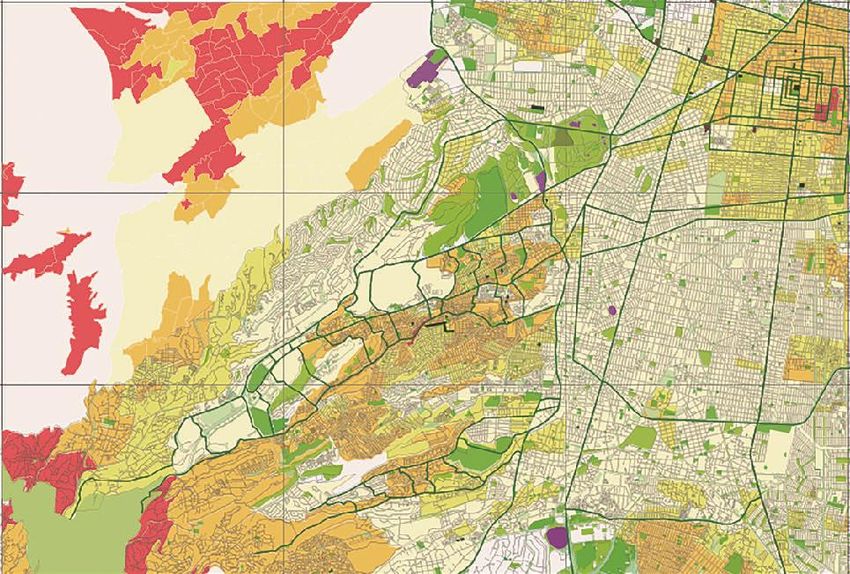
32 When juxtaposing socio-economic information from the Mexican National
33 Institute of Statistics and Geography (INEGI), onto the Google Maps exercise
34 of mapping the green areas, we found that the lower income areas contain
35 much less formal parks and green squares than the higher income neighbour-
36 hoods [see Figure 37]. The strategy, therefore, for the proposal was:
37
38 a. to connect the existing different scale parks through tree-lining streets
39 and avenues [see Figure 38];
40 b. to consider the cemeteries as part of the park system [see Figure 38];
41 c. to consider private clubs, golf courses, private gardens as ‘landscape’ in
42 beautifying the road network and contributing to ‘connect’ [see Figure
43 39];
44 d. to use the ‘borders’ between different economic level neighbourhoods
45 as ‘suturing connectors’, in order to distribute the value of green land-
46 scape and improve the areas between these levels [see Figure 37];
302020-3720-AJA-PLA
1 e. to find park area potential in the low-income areas, which tend to have
2 less parks than the high-end neighbourhoods [see Figure 40];
3 f. to use the ravines as linear promenade-parks and ‘binding’ areas be-
4 tween neighbourhoods [see Figure 41];
5 g. to use the primary east-west avenues as ‘bridges’ between the three ge-
6 ographic sectors [see Figure 42].
7
8 Figure 36. Selected Zone
9
10 Source: Elaborated by Roxana Hernández and Fernando Gómez 2019.
11
312020-3720-AJA-PLA
1 Figure 37. Socio-Economic Information
2
3 Source: Elaborated by Roxana Hernández and Fernando Gómez 2019.
4
5
6
7
322020-3720-AJA-PLA
1 Figure 38. Parks Calssification
2
3 Source: Elaborated by Roxana Hernández and Fernando Gómez 2019.
332020-3720-AJA-PLA
1 Figure 39. Private Clubs and Gardens, Golf Courses
2
3 Source: Elaborated by Roxana Hernández and Fernando Gómez 2019.
342020-3720-AJA-PLA
1 Figure 40. Low-Income Areas Tend to Have Less Parks than the High-End
2 Neighbourhoods
3
4 Source: Elaborated by Roxana Hernández and Fernando Gómez 2019.
5
6 Figure 41. Project Proposal
7
8 Source: Elaborated by Roxana Hernández and Fernando Gómez 2019.
352020-3720-AJA-PLA
1 Figure 42. Project Proposal, Zoom-in of the Selected Zone
2
3 Source: Elaborated by Roxana Hernández and Fernando Gómez 2019.
4
5
6 Conclusions
7
8 A park system does not have to be designed from scratch. It can be incor-
9 porated into an already existing, and even historical, urban form. It is a method
10 of exploring and finding the potential of open space in the city, beginning with
11 the careful exploration of up-to-date maps and using the geographical Infor-
12 mation tools.
13 As Tom Turner has stated, “Designing towns and gardens involves the
14 layout of enclosed outdoor space. Sixteenth-century Isfahan, seventeenth-
15 century Paris, eighteenth-century London, nineteenth-century Washington, D.C
16 and the Garden Cities of the twentieth century were composed like gardens, to
17 their immense benefit.” (Turner, Tom, 2005, p. 3).
18 In the case of Mexico City, thinking about social cohesion was a key crite-
19 ria. Parks should work as stitches that join neighbourhoods in unfavorable con-
20 ditions and privileged populations, in an attempt to blur the boundaries be-
21 tween different socio-economic levels. In our view, this is an innovative ‘sutur-
22 ing’ strategy, to bind together neighbourhoods, create community and structure
23 the city by building identity.
362020-3720-AJA-PLA
1 References
2
3 Bacon, Edmund N. Design of Cities. Estados Unidos: Penguin Books, 1976.
4 Beveridge, Charles E. and Paul Rocheleau. Frederick Law Olmsted: Designing the
5 American Landscape, New York, Rizzoli International Publications, Inc., 1995.
6 Boesiger, Willy. Le Corbusier, London, Thames and Hudson, Ltd., 1972.
7 Brown, Lance Jay, Dixon, David y Gillham, Oliver. Urban Design For An Urban
8 Century. New Jersey: John Wiley & Sons, Inc., 2009.
9 Burnham, Daniel H y Bennet, Edward H. Plan of Chicago. Chicago: The Great Book
10 Foundation, 1909.
11 Eguiarte, Estela. La Ciudad Pensada: una ciudad que no fue. México 1900-1911,
12 Revista Arqui tectónica (Gigliola Carozzi, Ed.), No. 6, Ciudad de México, U. Ibe-
13 roamericana, Otoño 2004.
14 Gruppo ‘2C’. “Cerdà’s Barcelona. The Elements of Ensanche and construction of the
15 block, LOTUS International, No. 23, New York, Rizzoli International Publica-
16 tions, Inc., 1979/II.
17 Farr, Douglas. Sustainable Urbanism: Urban Design with Nature, New Jersey, John
18 Wiley & Sons, Inc., 2008.
19 Hall, Peter. Cities of tomorrow: an Intellectual History of Urban Planning and Design
20 since 1880. Oxford: Blackwell Publishers, 1996.
21 Ingold, Tim. The Temporality of Landscape, Contemporary Archaeology in Theory:
22 The New Pragmatism, Robert W. Preucel, Stephen A. Mrozowski, Blackwell
23 Publishers Ltd (2e, 2010) p. 71. (February, 2019)
24 Jordan, David P. Transforming Paris: the life and labors of Baron Haussmann. New
25 York: The Free Press, Simon and Schuster, Inc., 1995.
26 Leclerc, Bénédicte, et.al (Ed.). Forestier, Jean Claude Nicolas. Grandes villes et sys-
27 tèmes de parcs: suivi de deux mémoires sur les villes impériales du Maroc et sur
28 Buenos Aires. Paris: Editions Norma, 1997.
29 Lupton, Ellen. Design is Storytelling. New York:Cooper Hewitt, Smithsonian Design
30 Museum, 2017.
31 Moore, Charles (Ed.). Plan of Chicago, Centennial Edition, Daniel H. Burnham and
32 Edward H. Bennett, Chicago, The Great Books Foundation, 2009.
33 Morris, A.E.J. History of Urban Form Before the Industrial Revolution. London:
34 George Godwin Limited, 1979.
35 Panerai, Philippe; Jean Castex, Jean-Charles Depaule. Formes Urbaines: de l’îlot à la
36 barre. Marseille: Éditions Parenthèses, 2001.
37 Tate, Alan. Great City Parks. London. SPON Press, 2004.
38 Tate, Alan. Great City Parks. New York. SPON Press, 2004.
39 Turner, Tom. Garden History: Philosophy and Design 2000 BC–2000 AD, New York,
40 SPON Press, Taylor & Francis Group, 2005.
41
42 Internet Articles
43
44 Ingold, Tim. The Temporality of Landscape. Contemporary Archaeology in Theory:
45 The New Pragmatism, Robert W. Preucel, Stephen A. Mrozowski, Blackwell
46 Publishers Ltd (2e, 2010) p. 71. (February, 2019)
47 https://books.google.com.mx/books?id=Ccsmpug-xaoC&pg=PA71&lpg=PA71&dq=
48 There+can+be+no+places+without+paths,+along+which+people+arrive+and+de
49 part;+and+no+paths+without+places.&source=bl&ots=2yKUD3yK2p&sig=ACf
50 U3U2YlRk47pLkJ5CCRsh3fZPKV1RVng&hl=en&sa=X&ved=2ahUKEwiTm5j
372020-3720-AJA-PLA
1 v6fzhAhUC-6wKHUegCxkQ6AEwAXoECAkQAQ#v=onepage&q=There%20c
2 an%20be%20no%20places%20without%20paths%2C%20along%20which%20pe
3 ople%20arrive%20and%20depart%3B%20and%20no%20paths%20without%20p
4 laces.&f=false
38You can also read