East Yale Avenue Corridor Study - DRAFT February 2021 - City and County of Denver
←
→
Page content transcription
If your browser does not render page correctly, please read the page content below
East Yale Avenue Corridor Study
DRAFT
February 2021
[this page left intentionally blank]

East Yale Avenue Corridor Study - DRAFT                                          ii
ACKNOWLEDGEMENTS
City and County of Denver                                                            Stakeholder Working Group
Geneva Hooten               Denver Department of Transportation and Infrastructure   Stuart Anderson        Transportation Solutions
Ashlee Grace                Denver Department of Transportation and Infrastructure   Paul Bloede            University Neighbors Neighborhood Association
John Lasala                 Denver Department of Transportation and Infrastructure   Chessy Brady           Regional Transportation District
Emily Cushman               Denver Department of Transportation and Infrastructure   Tony Brindisi          Colorado Department of Transportation
Eileen Yazzie               Denver Department of Transportation and Infrastructure   Hsu-Kun (Nick) Cheng   Colorado Department of Transportation
Laurie Tabachnick           Denver Department of Parks and Recreation                Melanie Colletti       Ross-University Hills Library
Edson Ibanez                Denver Community Planning and Development                Liz Davis              University Hills North Community
                                                                                     Paul DesRocher         Regional Transportation District
Denver City Council District 4                                                       George Gramer          Cherry Hills Vista Community Association
                                                                                     Kelly Hartshorn        South Jackson Street Neighborhood Association
Kendra Black                District 4 Council Representative                        Carly Helwick          Denver Fire Department
Kathy Gile                  Council Aide                                             Danny Herrmann         Colorado Department of Transportation
                                                                                     Emily Holben-Walker    Mayor’s Pedestrian Advisory Committee, Southside
Denver City Council District 6                                                                              Unified, University Hills Neighborhood Association
                                                                                     Tom Klein
Paul Kashmann               District 6 Council Representative                        Mark Kristensson       University Park Community Council
Brent Fahrberger            Council Aide                                             Adriana Lara           Denver Fire Department
                                                                                     Molly McKinley         Denver Streets Partnership
Consultant Team                                                                      Jennifer Neuhalfen
                                                                                     Alberto Paez
                                                                                                            University Hills North Community
                                                                                                            Denver Fire Department
Jason Freitas               Parsons                                                  Stan Poladsky          Mayor’s Bicycle Advisory Committee
Amber Haines                Parsons                                                  Jalynn Rasmussen       Flatirons Church
Gabi Johnson                Communication Infrastructure Group (CIG)                 Jordan Rudel           Colorado Department of Transportation
Lucy Lee                    Communication Infrastructure Group (CIG)                 Tom Schafer            South Jackson Street Neighborhood Association
Yishuen Lo                  Livable Cities Studio                                    Peter Sokol-Hessner
Ryan Mulligan               Parsons                                                  Cathy Valencia         Arapahoe County
Gabrielle Renner            Apex Design                                              Jessica Vargas         Denver Streets Partnership
Katherine Ryan              Parsons                                                  John Voboril           City of Englewood
Meredith Wenskoski          Livable Cities Studio

East Yale Avenue Corridor Study - DRAFT                                                                                                                     iii
[this page left intentionally blank]

East Yale Avenue Corridor Study - DRAFT                                          iv
TABLE OF CONTENTS
EXECUTIVE SUMMARY....................................................................................................................................................................1
INTRODUCTION TO THE EAST YALE AVENUE CORRIDOR.....................................................................................................................3
      Context and Project History ........................................................................................................................................................................................................................ 3
      Vision and Goals .......................................................................................................................................................................................................................................... 6
      Public Process and Involvement ................................................................................................................................................................................................................ 8

RECOMMENDATIONS FOR EAST YALE AVENUE ...............................................................................................................................11
     Corridor-Wide Infrastructure ..................................................................................................................................................................................................................... 15
     North-South Connections .......................................................................................................................................................................................................................... 20
     McWilliams Park ........................................................................................................................................................................................................................................ 23
     Yale Way ..................................................................................................................................................................................................................................................... 26
     Yale & Colorado Intersection .................................................................................................................................................................................................................... 29
     Yale Station ................................................................................................................................................................................................................................................ 36
     Yale Station to the High Line Canal .......................................................................................................................................................................................................... 39

APPENDICES ...............................................................................................................................................................................46

East Yale Avenue Corridor Study - DRAFT                                                                                                                                                                                                                             v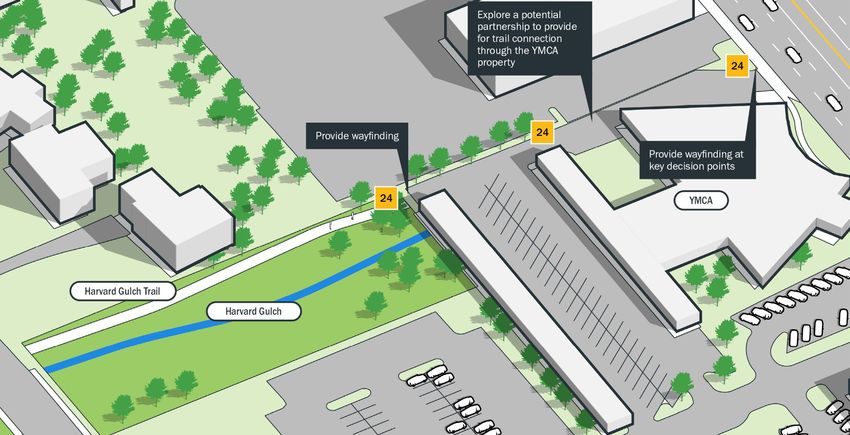
[this page left intentionally blank]

East Yale Avenue Corridor Study - DRAFT                                          vi
EXECUTIVE SUMMARY
jurisdictions and municipalities present along the corridor. Through several
months of meeting with stakeholders and two public open houses (held
virtually due to COVID-19 safety considerations), three overarching Study
goals were developed that helped shape the Study’s vision and guided the
Introduction eventual development of recommendations. These goals are:
1. Safety: Create an environment where everyone feels they can move
safely, no matter their mode of travel, and prevent serious injuries
The East Yale Avenue corridor will serve neighborhoods and fatalities through corridor-wide infrastructure improvements
and connect people, places, and services through a safe (including adjacent trails and streets).
and efficient transportation network. 2. Building Connections: Create safe and convenient connections and
improve access along the East Yale Avenue corridor where people
The East Yale Avenue Corridor Study (Study) is a planning process led by the can easily get to where they want to go.
City and County of Denver (City) to engage residents and businesses 3. Multimodal: Create an equitable and connected multimodal network
throughout the corridor and develop a plan for East Yale Avenue between to move more people by walking, biking, and taking transit as part of
Downing Street on the west and the High Line Canal crossing at Yale west of their everyday lives.
Holly Street on the east, as shown in Figure 3.
The Study traverses six of Denver’s 78 city neighborhoods, including
University Park, Wellshire, University, University Hills, Hampden, and FIGURE 1 - YALE AT EAST YALE CIRCLE
Goldsmith. Only one of these neighborhoods, University Park, has an official
neighborhood plan (completed in 2008, available here). Several plans have
been completed that support these neighborhoods, including:
Colorado Boulevard Plan (1991)
Yale Station Area Study (2003)
Colorado Station Area Framework Plan (2003)
Yale Corridor Traffic Study (2014)
Denver Urban Waterways Restoration Study – Harvard Gulch (2018)
None of these previous planning efforts have focused on developing a
multimodal, safe, and community-driven solution for East Yale Avenue.
Process and Goals
The project team, in coordination with City staff and the project Stakeholder
Working Group (SWG), examined the existing conditions, past and adjacent
studies, opportunities and constraints, and coordinated with the various
East Yale Avenue Corridor Study - DRAFT 1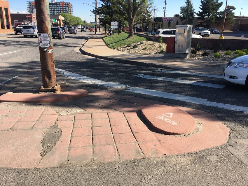
Key Recommendations                                                                                                FIGURE 2 - YALE AT MCWILLIAMS PARK
The Study included a comprehensive alternatives analysis effort to identify,
evaluate, and prioritize 35 recommendations that were developed through
input from previous planning efforts, the Study stakeholder working group,
public open houses, input from residents along corridor. Further information
regarding these recommendations, including key implementation strategies
and potential funding sources are detailed in this Study.

 RANK                           RECOMMENDATION/PROJECT
    1     Shared use path on Yale from Colorado Boulevard to the High Line Canal
    2     Repair/widen sidewalks along East Yale Avenue (Figure X)
    3     Bike/ped crossing safety improvements at the Yale & I-25 interchange
          Upgrade the existing bike lane on Yale to a protected bike lane and extend the
    4
          facility west to Downing Street
          Install leading pedestrian indicator (LPI)/bike detection technology at
    5
          Amherst Avenue and Colorado Boulevard
    6     Enhance bike/ped crossing at Yale & Franklin Street

                                                                          FIGURE 3 - CORRIDOR AND FOCUS AREA MAP

East Yale Avenue Corridor Study - DRAFT                                                                                                                 2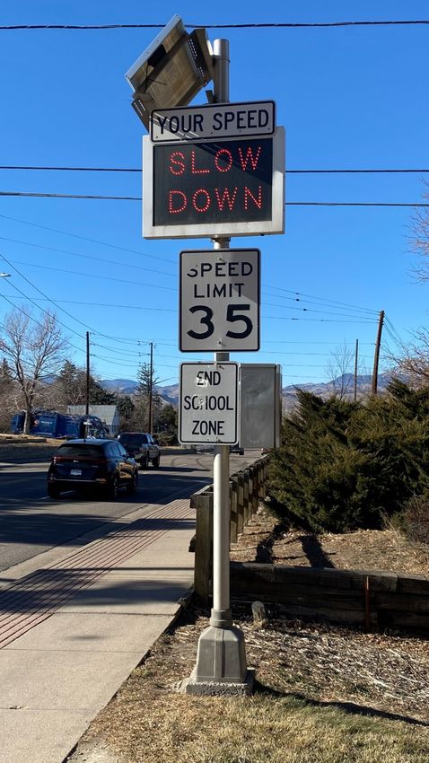
INTRODUCTION TO THE EAST
                                                                                  to, among other goals, identify necessary improvements on East Yale Avenue
                                                                                  to accommodate all modes of transportation efficiently and safely.

YALE AVENUE CORRIDOR                                                              The study’s final recommendations were presented in six primary categories,
                                                                                  including:

                                                                                  1. SIDEWALK IMPROVEMENTS
Context and Project History                                                       Identified improvements included sub-standard sidewalk widths (often less
                                                                                  than three feet), missing ADA ramps, sidewalk obstructions (i.e. power poles,
East Yale Avenue is a very diverse corridor, serving as a vital link between
                                                                                  streetlights), missing sidewalk segments, and missing connections to RTD
historic neighborhoods, north-south travel thoroughfares, RTD bus and light
                                                                                  stops.
rail corridors, and bicycle and pedestrian networks. That link, however, boasts
significantly different characteristics throughout its 2.5-mile span. West of
                                                                                  2. TRAFFIC OPERATIONS
Colorado Boulevard to Downing Street, Yale is a two-lane road (one each
direction) through a stable residential area. The western project limit at        These recommendations included queueing capacity improvements to
Downing Street hosts connections to both the RTD Route 12 and more than           various segments of the Yale Avenue interchange at I-25, turn lane
3,300 jobs at Porter Adventist Hospital, Swedish Medical Center, and Craig        improvements at Yale Avenue and Holly Street, and a westbound dedicated
Hospital. East of Colorado to the High Line Canal (west of Holly Street), Yale    turn arrow at Monaco Parkway.
varies from a five- to seven-lane cross-section supporting a wide variety of
land uses including commercial centers, residential, transit-oriented develop,    3. STREET RECONSTRUCTION
and access to I-25 and the High Line Canal.
                                                                                  Capital-intensive improvements to the roadway cross-sections enabling
Even though the halves of the corridor are different, the East Yale Avenue        multimodal travel improvements promoting safety and efficiency were
Multimodal Corridor Study became the perfect opportunity to create a              identified throughout the study area.
package of context-sensitive projects to support a cohesive vision that puts
people first.                                                                     4. TRAIL AND PEDESTRIAN CROSSINGS
                                                                                  Movement across East Yale Avenue, particularly throughout the eastern
                                                                                  segments of the corridor, can be dangerous due to both traffic volumes and
Previous Studies                                                                  speeds. These factors are particularly troublesome near high-volume crossing
                                                                                  locations such as at Yale Station and the High Line Canal. The study
Yale Corridor Traffic Study (2014)                                                identified other study opportunities (now complete) to improve crossings at
                                                                                  these locations in addition at the High Line Canal east of Monaco Parkway.
The only recent study that evaluated any segment of the Yale Avenue
corridor, The Yale Corridor Traffic Study (January 2014) was a cooperative        5. BUS STOPS
multimodal technical study between the City and County of Denver and
Arapahoe County. It evaluated East Yale Avenue from Fairfax Street (Denver)       These recommendations included minor improvements at select locations
on the west to Syracuse Way (Arapahoe County) on the east. The study looked       along the corridor to introduce or enhance transit access.

East Yale Avenue Corridor Study - DRAFT                                                                                                                           3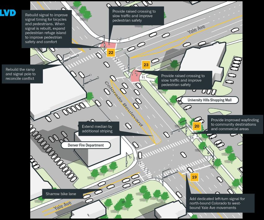
6. OPERATIONS AND MAINTENANCE                                                     •   An at-grade crossing of the East Harvard Gulch Trail at University
                                                                                      Boulevard (about 500 feet north of East Yale Avenue) to provide a
Recommendations included signal timing modifications to improve
                                                                                      high-quality user experience rather than traveling 850 feet out-of-
pedestrian safety in addition to traffic enforcement and the prevalence of cut-
                                                                                      direction to comfortably and safely cross University Boulevard.
through traffic.
                                                                                  •   A 300-foot trail to connect the East Harvard Gulch Trail to Colorado
                                                                                      Boulevard from its current terminus at Jackson Street. This pathway
Strategic Transportation Plan (2008)                                                  would formalize an existing pathway through Schlessman Family
                                                                                      YMCA’s parking lot.
The Denver Strategic Transportation Plan recognizes the importance of
                                                                                  •   An improved crossing of the High Line Canal across East Yale Avenue
moving people, not just vehicles with the goal of creating a multimodal
                                                                                      just west of Holly Street. While this improvement is not evaluated or
transportation system to support a viable, connected, and sustainable city.
                                                                                      otherwise defined as part of this Study, it’s importance to the
Recommendations related to improvements along East Yale Avenue were                   community and the desire to see it improved is well documented.
included in the 2008 report, including pedestrian improvements to connect             Improvements to this crossing are funded through the Elevate
Yale Station from High Line Canal to the west and East Yale Way at Colorado           Denver bond program. This crossing is also identified as a Phase 2
Boulevard intersection turn-lane improvements.                                        High-Priority Bikeway improvement in Denver Moves: Pedestrians &
                                                                                      Trails.

Mayor’s Mobility Action Plan (2017)                                                        FIGURE 4 - BUFFERED BIKE LANE ON YALE AT CLAYTON STREET

The Mayor’s Mobility Action Plan identified actions to reduce single-occupant
vehicle mode share, eliminate traffic fatalities and serious injuries, reduce
greenhouse gas emissions, and increase access to technologies and mobility
for everyone, regardless of location of socioeconomic status.

Denver Moves: Bicycles
Denver Moves: Bicycles proposes on-street bikeways crossing East Yale
Avenue on Franklin Street, St. Paul Street, and Dahlia Street. The plan also
calls for the extension of the East Harvard Gulch Trail east of Colorado
Boulevard from its current terminus at Jackson Street and the study of a
reinforced multimodal connection from Dahlia Street east to the High Line
Canal.

Denver Moves: Pedestrians & Trails
Denver Moves: Pedestrians & Trails proposed several recommendations for
pedestrian infrastructure improvements in the Study area, including:

East Yale Avenue Corridor Study - DRAFT                                                                                                                   4
Denver Moves: Transit
FIGURE 5 - TRAFFIC ON YALE AT DAHLIA STREET
Denver Moves: Transit identified Colorado Boulevard as a High-Capacity
Transit (HCT) Corridor and University Boulevard as a Medium-Capacity Transit
(MCT) Corridor.
• High-capacity transit (HCT) corridors are identified as those corridors
with high levels of passenger capacity, very frequent services, and
high-quality design that would benefit from improvements such as
enhanced stops and easier access to stations. Other features of HCT
corridors include improved service frequency, dedicated transit-only
lanes, major streetscape changes, transit vehicles with special
branding.
• Medium-capacity transit (MCT) corridors have elements that help to
move buses through traffic in key locations as well as improved
stops and pedestrian and bicycle connections. Other features of MCT
corridors include improved service frequency, queue jumps or
bypass lanes, transit vehicles with special branding, and upgraded
connections to stops and stations.
East Yale Avenue Corridor Study - DRAFT 5Vision and Goals Safety
The East Yale Avenue corridor will serve neighborhoods Create an environment where everyone feels they can
and connect people, places, and services through a safe move safely, no matter their mode of travel, and prevent
and efficient transportation network. serious injuries and fatalities through corridor-wide
infrastructure improvements (including adjacent trails
The ultimate vision for East Yale Avenue will incorporate a multitude of and streets).
multimodal transportation infrastructure elements to enable safe and
efficient travel along – and across – Yale between Downing and the High Line Transportation safety has become a pervasive issue throughout the Denver
Canal. There has not been a concerted effort in the past to address metro area as roads have become busier and speeds have increased. Years
multimodal needs along the corridor. of automobile-dominated growth has resulted in a corridor with wide travel
Prioritizing safe travel, regardless of mode, presents the opportunity to lanes, high traffic volumes, substandard on-street bike facilities, and narrow
introduce best practices to transportation infrastructure elements of the sidewalks. There are opportunities throughout the Study area to improve
corridor that the public and project team have identified as needing attention. safety for the traveling public – regardless of mode – and help move towards
The Yale corridor has different characteristics dependent upon the location the City’s ambitious goal established through the Vision Zero Program of
throughout the corridor. The corridor is nearly exclusively residential with eliminating traffic-related deaths and serious injuries by 2030.
lower traffic volumes and speeds to the west while it has mixed land uses,
higher speeds, traffic volumes, and accident rates to the east. No one single Building Connections
solution will improve safety throughout a corridor with multiple characteristics
such as Yale. The Study has identified a variety of safety improvements at
locations throughout the corridor which, if implemented, will enable safer Create safe and convenient connections and improve
movements along and across Yale. access along the East Yale Avenue corridor where
Enabling efficient travel – regardless of transportation mode – throughout the people can easily get to where they want to go.
Study corridor is important to ensure that Yale is for everyone, not just
vehicles. Multimodal travel presents opportunities for improved health, air From McWilliams Park and Yale Station to St. Anne’s School and the
quality, and general quality of life. The recommendations developed through Schlessman YMCA, there are numerous community destinations throughout
the Study address infrastructure gaps, signal timing, and other elements that the Study area. Building safe, accessible connections to those assets will
provide for a truly multimodal transportation corridor without prioritizing one help ensure that residents and visitors alike can easily find and access these
mode over any other. places.
Three overarching goals were created to guide identification and analysis of
the Study’s eventual recommendations. They focused on safety throughout
the Study area, building connections, and reinforcing the area’s multimodal
network.
East Yale Avenue Corridor Study - DRAFT 6Multimodal
FIGURE 6 - YALE & COLORADO BOULEVARD
Create an equitable and connected multimodal network
to move more people by walking, biking, and taking
transit as part of their everyday lives.
The Study area has numerous multimodal transportation options (current and
planned), but few links between them. By working to effectively link these
options (i.e. East Harvard Gulch Trail, High Line Canal, RTD transit service,
future bike lanes on Franklin, St. Paul, and Dahlia Streets), residents and
visitors will have a safe, efficient, and viable alternative to driving. This is by
no means intended to place preference upon one transportation mode. It is,
however, intended to provide a reasonable option to those who want it.
East Yale Avenue Corridor Study - DRAFT 7Public Process and Involvement a virtual interactive map to solicit input on the Study’s draft
recommendations.
COVID-19 posed a unique challenge for the project team to gather public During these open houses, input from the general public was solicited
input from stakeholders. However, the project team was able to virtually through interactive polling questions, a live chat feature, Q&A sessions
engage with hundreds of residents and stakeholders to gather input, integrated into the presentations, and e-mails sent to the project team. The
opinions, and concurrence. The project team held five virtual SWG meetings project email, established by the City, received more than 60 comments and
and two virtual public open houses. questions. Summaries of the Stakeholder Working Group and Virtual Open
Houses are included in the appendix. Figures 8 and 9 provide additional
Stakeholder Working Group details about the virtual open houses. Appendix C provides virtual public
open house meeting summaries.
Stakeholder Working Group (SWG) meetings engaged a smaller, more
targeted group who served as ambassadors for their community. Having a FIGURE 8 - VIRTUAL OPEN HOUSE STATISTICS
more intimate group allowed for open discussions and engagement, which
led to the development of a comprehensive vision for future improvements
throughout the Study area. The project team collaborated with the SWG to
define the Study’s vision, goals, and focus areas and to help identify
recommendations. Key issues and concerns were also used to help guide the
Study’s planning and outreach efforts. Figure 7 below provides further details
about the SWG. Appendix B provides SWG meeting summaries.
FIGURE 7 - STAKEHOLDER WORKING GROUP MEETING STATISTICS
Elected Officials
Representatives from Denver City Council Districts 4 and 6 were integral to
the success of the Study. Councilwoman Kendra Black (District 4) and
Virtual Open Houses
Councilman Paul Kashmann (District 6), as well as council staff, helped
The Study’s first open house was held in April 2020 to introduce the project, coordinate focused updates to constituents through their respective
gather feedback from the public about the Study area, solicit their opinions newsletters. These included general project updates, presentations, and
and concerns, and share findings from the Study’s existing conditions other general information about the Study.
analysis. The Study’s second open house was held in September 2020 and
served to review the vision and goal statements and demonstrate how to use
East Yale Avenue Corridor Study - DRAFT 8Additional information about the map and how it was publicized are included
FIGURE 9 - YALE STUDY WEBSITE AND SOCIAL MEDIA STATISTICS in Figures 10 and 11. A screenshot of the interactive map is included in
Figure 12.
The interactive map received 152 public comments, 100 likes, and 17
dislikes. Overall, those who utilized the interactive map were supportive of
the Study’s recommendations.
FIGURE 10 - INTERACTIVE MAP COMMENT DETAILS
Advertising the interactive map’s availability was a collaborative effort
involving the Stakeholder Working Group, social posts on Nextdoor,
Facebook, and Twitter, and a temporary banner on the project website. 20
yard signs with a scannable QR code directed people to the project’s website
and interactive map were placed at six locations along the corridor
highlighting its availability. The QR code was scanned 114 times.
FIGURE 11 - STUDY YARD SIGN UTILIZATION STATISTICS
Interactive Map
COVID-19 forced the project team to pivot away from traditional public
feedback collection efforts to ensure safety for the project team and the
community throughout the Study area. In lieu of these in-person touchpoints,
an interactive map detailing the projects draft recommendations was
developed. The map empowered stakeholders and residents to review the
specifics regarding the recommendations, provide a rating (like/dislike), and
leave general comments.
East Yale Avenue Corridor Study - DRAFT 9FIGURE 12 - YALE AVENUE INTERACTIVE MAP East Yale Avenue Corridor Study - DRAFT 10
3. Alternatives that move forward into conceptual engineering will
evaluate drainage to ensure the design will not further degrade
RECOMMENDATIONS FOR existing deficiencies along the corridor. However, corridor-wide
drainage improvements will be addressed by other capital
EAST YALE AVENUE improvement projects. Drainage improvements throughout this area
have been identified as part of the 2019 Storm Drainage Master
Plan.
As a result of these efforts and thanks to the participation of residents and
Recommendations Development and Screening stakeholders along the corridor, 35 alternatives were identified for
The recommendations developed as part of the Study were created through a analyzation and further study. These were screened based upon a variety of
variety of efforts, including: quantitative and qualitative measures
Review of previously completed City and County of Denver plans, Detailed information related to the screening of the recommendations
including those detailed on Page 4; presented in this Study can be found in the Alternatives Analysis Technical
Five Study Stakeholder Working Group and two virtual public open Memorandum, included in Appendix D.
house meetings;
Input through the Study’s web-based interactive map;
Public input through the Study’s e-mail address; and FIGURE 13 - CROSSWALK AND PEDESTRIAN REFUGE AT YALE AND COLORADO BOULEVARD
Existing conditions analysis.
The alternatives development and evaluation process integrated public and
stakeholder input at each step of the process, including:
Establishing the goals and guiding principles for the Study;
Incorporating previous Study recommendations and stakeholder
suggestions to compile and examine a broad range of alternatives;
Establishing evaluation criteria to screen the alternatives; and
Alternatives refinement and prioritization
Three base assumptions were developed early in the project to further guide
the development of multimodal recommendations and alternatives,
essentially serving as an initial screening. These assumptions were:
1. Right-of-way (ROW) acquisitions will not occur along or adjacent to
the corridor;
2. In accordance with complete streets ideology and direction, which
the City has adopted, there will be no additional vehicle capacity or
lane miles added along the corridor; and
East Yale Avenue Corridor Study - DRAFT 11Use of Previous Planned/Identified and/or TABLE 1 - PREVIOUS PLANNED/IDENTIFIED AND/OR FUNDED PROJECTS
Funded Projects ID
RECOMMENDATION/PROJECT
ORIGINAL
SOURCE
The Study thoroughly reviewed recommended multimodal improvements that
Sidewalk from Clayton to Steele Street on south side of
impact movements on the East Yale Corridor from previous studies as well as A Denver CIP
McWilliams Park, including ADA curb ramp
those multimodal improvement projects that are in the process of obtaining,
Safer Main
or have obtained, funding to move forward into construction and Signal replacement at Yale & Colorado Boulevard (northern Streets grant
implementation. While these much-needed transportation infrastructure B
intersection) application
projects were not included in the Alternatives Analysis screening process as (DRCOG)
part of this Study, they played an integral part in the development of a Denver Moves:
comprehensive vision, project goals, and public engagement effort. They were At-grade crossing of the East Harvard Gulch at University
C Pedestrians &
also included for reference as part of the Study’s interactive map. Boulevard
Trails
These previous recommendations and planned projects are listed in Table 1 Elevate Denver
D New signal at Yale & East Yale Circle
and identified in the focus area maps of this Study. Bond Program
Multimodal infrastructure improvements on Yale from I-25 Elevate Denver
E
east to Quebec Street Bond Program
High Line Canal crossing improvements near the Elevate Denver
F
intersection of Yale & Holly Street Bond Program
Wrong way driving signal and signage improvements at Yale
G CDOT
& I-25
Establish University Boulevard as a medium-capacity Denver Moves:
H
transit corridor Transit
Establish Colorado Boulevard as a high-capacity transit Denver Moves:
I
corridor Transit
Sidewalk construction from Marion Circle to Lafayette Elevate Denver
J
Street Bond Program
On-street bike facilities on Franklin, St. Paul, and Dahlia Denver Moves:
K
Street Bicycles
East Yale Avenue Corridor Study - DRAFT 12Prioritization Long-Term
The Study began with the goal of identifying and prioritizing community The long-term recommendations include those which require a major capital
supported multimodal transportation infrastructure improvements that were investment, intensive coordination with partners and/or other jurisdictions, or
both feasible and aligned with the goals, priorities, and evaluation criteria have significant external project issues/risks such as potential right-of-way
utilized through the Alternatives Analysis process. The project lists that have acquisitions, utility coordination, or substantial planning or engineering.
been generated for each Focus Area, as well as for the overall corridor, These projects are more complex and require further evaluation to determine
contain a variety of improvements. Each provides an incremental step their need.
towards achieving the corridor’s vision of connecting people, places, and
FIGURE 14 - SIDEWALK WIDTH ON YALE AT CLERMONT DRIVE
services through a safe and efficient transportation network.
Given the unpredictability of future resources and funding, this Study details
these recommended improvements in short-, mid-, and long-term categories.
The recommendations were also measured against the informative
considerations identified as part of the Alternatives Analysis process. Further
information on how these recommendations were analyzed and scored can
be found in the Alternatives Analysis Technical Memo included as an
appendix to this Study.
Short-Term
These short-term improvements represent “quick wins” at various locations
throughout the Study area and present a range safety, connections, and
multimodal benefits. They are, by and large, relatively inexpensive or have
clear funding opportunities, boast broad community support, require minimal
coordination, and further the project goals of increasing safety, building
connections, and developing the multimodal network.
Mid-Term
These mid-term recommendations represent safety, connectivity, and
multimodal improvements that require a more substantial capital investment,
more focused coordination with partners and other jurisdictions, and/or
additional planning efforts to validate their design and eventual construction.
Several are also dependent upon other recommendations or anticipated
developments to warrant their installation.
East Yale Avenue Corridor Study - DRAFT 13Focus Areas Further information about these areas and other corridor-specific information
can be found in the Existing Conditions Report, included in Appendix A.
The corridor was divided into seven focus areas based on adjacent land uses,
existing conditions, and infrastructure demands. The proposed cross-sections
for each character area, as shown throughout this report, will guide future .
funded construction efforts that address lane width modifications, sidewalk
improvements, and multimodal infrastructure design and construction. As a
result, these elements can be built efficiently and in their optimal location,
minimizing throwaway cost and redesign.
The recommendations developed through the Study process are generally
categorized across seven focus areas and depicted in Figure 15 below. The
focus areas include:
1. North-South Connections
2. McWilliams Park
3. Yale Way
4. Yale & Colorado Intersection
5. Yale Station
6. Yale Station to the High Line Canal
7. Corridor-Wide Infrastructure
FIGURE 15 – EAST YALE AVENUE FOCUS AREAS
East Yale Avenue Corridor Study - DRAFT 14Corridor-Wide Infrastructure
There are numerous transportation infrastructure considerations that were
evaluated as part of the Study that did not fit into other focus areas. These
included intersection improvements as well as wayfinding and larger-scale
multimodal planning and design opportunities. These recommendations were
predominantly focused on enhancing safety for all modes throughout the
corridor.
The recommendations are mapped in Figure 16 with further details provided
in Table 2. Additional renderings and photographs are included in Figures 17
– 19.
FIGURE 16 - CORRIDOR-WIDE INFRASTRUCTURE RECOMMENDATIONS
East Yale Avenue Corridor Study - DRAFT 15TABLE 2 - CORRIDOR-WIDE INFRASTRUCTURE RECOMMENDATIONS
PROJECT PROJECT
RECOMMENDATION DESCRIPTION KEY IMPLEMENTATION STRATEGIES POTENTIAL FUNDING SOURCES
ID TYPE
SHORT-TERM
Improved wayfinding/signage alternatives throughout the corridor could be packaged
Improved signage/wayfinding to reinforce
together for efficient design and installation. This recommendation has a high return
5 community connections to the multimodal Wayfinding City general funds
with minimal investment, community support, and meets the Study’s multimodal
network
improvement goals. Wayfinding/signage examples are included in Figure 17.
MID-TERM
Internal coordination within DOTI is needed to evaluate the merits of a new bike facility
Design and install a new neighborhood
on Vassar Avenue in favor over the existing bike lanes on Yale. Further analysis is
bikeway on East Vassar Avenue from City general funds, Community
2 Bike needed to determine the best corridor, facility type, project limits, and connections to
approximately Josephine to Madison Streets Transportation Network (CTN) Program
the surrounding bicycle network. Would meet Study’s safety, connectivity, and
(exact facilities and project limits TBD)
multimodal goals.
Internal coordination and planning efforts within DOTI are needed to evaluate the
Upgrade the existing buffered bike lane on
merits of both an upgraded and expanded bike facility on Yale. Further analysis is
East Yale Avenue from Josephine to Jackson City general funds, Community
3 Bike needed to determine the best project limits and facility type. An example of a
Streets to a protected bike lane (PBL) and Transportation Network (CTN) Program
protected bike lane is included in Figure 18. Would meet Study’s safety, connectivity,
extend the bike facility west to Downing Street
and multimodal goals.
Design and install a new bicycle route on
Internal coordination and planning efforts within DOTI are needed to evaluate the
Amherst Avenue as an alternative to crossing
merits of a new bike facility bypassing Yale & Colorado. Further analysis is needed to
Colorado Boulevard at East Yale Avenue. The
determine the best project limits facility type. Coordination with CDOT focused on
routing accesses Amherst Avenue via Nielsen City general funds, Community
modifications to the signal at Amherst & Colorado is recommended to ensure smooth
6 Lane or Jackson Street, travels east across Bike Transportation Network (CTN) Program,
installation. Further detail, including a rendering of the crossing at Amherst Avenue
Colorado Boulevard and allows for travel north CDOT funds
and Colorado Boulevard is included in Figure 19. Further analysis also needed to
to East Yale Avenue via Brook Drive or south to
identify proper treatment, if any, at Yale & Jackson Street. Would meet Study’s safety,
the High Line Canal via Birch Street and
connectivity, and multimodal goals.
Highline Place.
LONG-TERM
Coordination between DOTI, CDOT, RTD, and Arapahoe County is recommended where
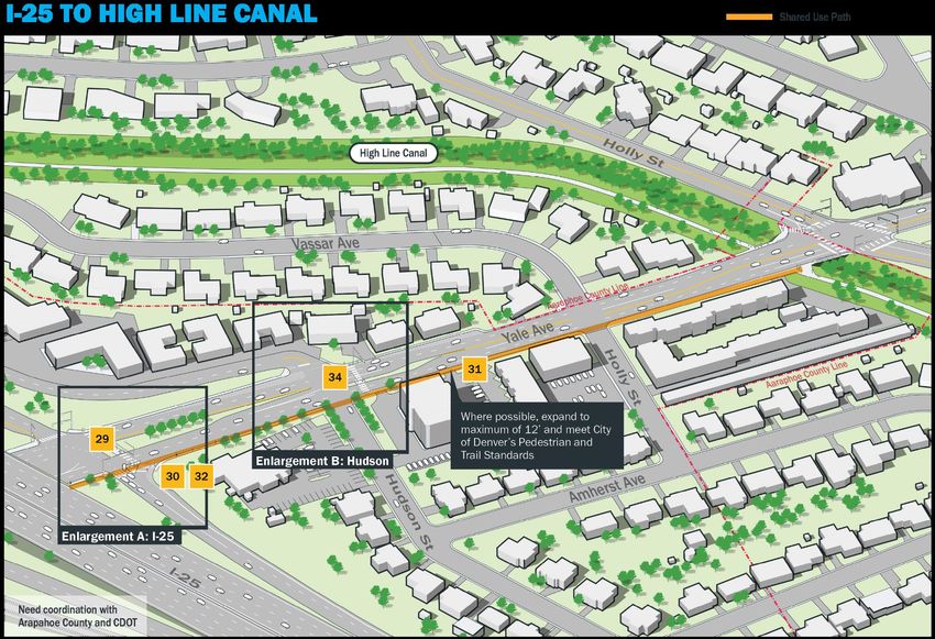
Design and install a shared use path on East jurisdiction is applicable to confirm a continuous path along this entire segment can
Yale Avenue from Colorado Boulevard east to be built. The Study recognizes the high capital investment needed to accomplish this
4 Bike/Ped City general funds
the High Line Canal (widths vary depending on as well as significant right-of-way constraints and limitations. Design efforts should
ROW constraints) also account for any potential drainage issues along these segments of Yale. Snow
and ice buildup concerns should be addressed if path is on south side of Yale.
East Yale Avenue Corridor Study - DRAFT 16FIGURE 17 - WAYFINDING EXAMPLES
Wayfinding/signage
improvements to direct
residents and visitors alike
to the corridor’s
multimodal connections
and various destinations
would provide a much-
needed source of
information while also
encouraging multimodal
travel along preferred
routes. These signs would
be placed a decision points
and key locations along the
various routes.
Partnerships with corridor
businesses/stakeholders
could be developed to
pursue enhanced signage,
as seen with the West
Colfax example to the left.
East Yale Avenue Corridor Study - DRAFT 17FIGURE 18 - PROTECTED BIKE LANE EXAMPLES
A protected bike lane
(PBL) is physically
separated from motor
traffic and distinct
from the sidewalk.
PBLs have different
forms but share
common elements –
the provide space that
is intended to be
exclusively or primarily
1
used by bicycles, and
2 are separated from
3 motor vehicle travel
lanes, parking lanes,
and sidewalks.
In situations where on-
street parking is
allowed, PBLs are
located to the curb-
side of the parking (in
contrast to bike lanes).
1 https://www.burlingtonvt.gov/DPW/ProtectedBicycleLanes
2 http://www.bikearlington.com/why-protected-bike-lanes-matter-to-us-all/
3 https://sfbike.org/news/were-changing-how-protected-bike-lanes-get-built/
East Yale Avenue Corridor Study - DRAFT 18FIGURE 19 - AMHERST AVENUE & COLORADO BOULEVARD BIKE LANE CROSSING RENDERING The Yale & Colorado Boulevard intersection poses safety risks for all travelers, regardless of mode. Diverting bicycle traffic off Yale to Amherst Avenue (by way of Nielsen Lane or Jackson Street), presents a safer alternative for everyone. Green conflict markings across Colorado would keep bicyclists top of mind for drivers and improved signal timing would offer a safer crossing for pedestrians. Bicyclists crossing Colorado traveling east could rejoin Yale by way of Brook Drive or the High Line Canal via Birch Street and Highline Place at Mamie D Eisenhower Park. East Yale Avenue Corridor Study - DRAFT 19
North-South Connections
Crossing East Yale Avenue is often seen as cumbersome, at minimum, due to
the lack of signalized or otherwise marked and protected crossings –
especially west of Colorado Boulevard. Some of these crossings are upwards
of 0.7 miles apart. These recommendations are spread throughout the
corridor and look to improve crossing options for both bicyclists and
pedestrians with minimal impact to vehicular traffic flows. These
recommendations are also focused on ensuring any new crossing meets all
relevant City and County of Denver standards.
The recommendations are mapped in Figure 20 with further details provided
in Table 3. Additional renderings and photographs are included in Figure 21

                                                        FIGURE 20 - NORTH-SOUTH CONNECTIONS RECOMMENDATIONS MAP

East Yale Avenue Corridor Study - DRAFT                                                                           20
TABLE 3 - NORTH-SOUTH CROSSINGS RECOMMENDATIONS
PROJECT PROJECT
RECOMMENDATION DESCRIPTION KEY IMPLEMENTATION STRATEGIES POTENTIAL FUNDING SOURCES
ID TYPE
SHORT-TERM
Improved signal timing at Yale & University Has a high return with a minimal investment, broad community support, and meets the
7 Boulevard to enable safer crossings, Vehicular Study’s safety and multimodal improvement goals by enhancing access to St. Anne’s City general funds
regardless of transportation mode School.
Has broad community support and meets the Study’s safety improvement goals. There
is a crossing approximately 400 feet to the west at South Clermont Drive, but the
Enhanced crossing per Denver’s Uncontrolled
transit stops for the 46 are located at Cherry. It’s unclear whether a crossing is
Crossing Guidelines at Yale Avenue and Cherry
8 Bike/Ped warranted at Cherry, and the exact location of the crossing needs further analysis City general funds
Street to better facilitate pedestrian
based upon guidelines established through the Uncontrolled Pedestrian Crossing
movement.
Guidelines (UPCG). Snow and ice buildup considerations should be considered on
south side of crossing. Crossing examples included in Figure 21.
Has broad community support and meets the Study’s safety improvement goals.
Recommendations 9 and 10 are located very close together (within 700 feet of each
Enhanced crossing per Denver’s Uncontrolled
other). Only one recommendation would realistically be designed and installed. The
9 Crossing Guidelines at Yale & Gaylord Street Bike/Ped City general funds
exact location of the crossing needs further analysis based upon guidelines
for safer access to St. Anne’s School
established through the UPCG. Snow and ice buildup considerations should be
considered on south side of crossing. Crossing examples included in Figure 21.
Has broad community support and meets the Study’s safety improvement goals.
Recommendations 9 and 10 are located very close together (within 700 feet of each
Enhanced crossing per Denver’s Uncontrolled
other). Only one recommendation would realistically be designed and installed. The
10 Crossing Guidelines at Yale & Race Street for Bike/Ped City general funds
exact location of the crossing needs further analysis based upon guidelines
safer access to St. Anne’s School
established through the UPCG. Snow and ice buildup considerations should be
considered on south side of crossing. Crossing examples included in Figure 21.
MID-TERM
Improved signal timing at Yale & Downing
Installing this recommendation should be contingency upon completion of the new
Street to accommodate new traffic conditions City general funds, potential impact
11 Vehicular development. Coordination with the City of Englewood is recommended to ensure new
following an anticipated development west of fees from new development
timing is palatable to both parties. Meets the Study’s safety and connectivity goals.
Porter Hospital
These enhancements should be dependent upon the new bike facility being planned,
Enhance bicycle and pedestrian crossings at
designed, and installed on both Streets. Further analysis is needed to determine the City general funds, Community
12 Yale & Franklin Street to better facilitate Bike/Ped
best elements to enhance the crossings. Meets the Study’s safety, connectivity, and Transportation Network (CTN) Program
movements across Yale
multimodal goals.
East Yale Avenue Corridor Study - DRAFT 21FIGURE 21 - MID-BLOCK CROSSING EXAMPLES
4
5
6
Cole Sukle, 14, was in the bike lane at East Yale and Madison Street
when he was tragically killed after being hit by a car on July 13, 2016.
Another teen, Jack Mahoney, was seriously injured in the crash.
Mid-block crossings enable safer crossings at locations not already
served by the existing traffic network. They typically have signage
noting the possible presence of bicyclists and/or pedestrians and a
demarcated crosswalk via striping. Denver’s Unprotected Pedestrian
Crossing Guidelines (UPCG) lays out the process/requirements for
identifying, evaluating, and installing a new crossing.
4 https://appinfoinc.com/wp-content/uploads/2018/12/midblock-median.jpg
5 https://cni.pmgnews.com/images/artimg/00003594986407.jpg
6 https://carmanah.com/wp-content/uploads/20161102_103639-1024x768.jpg
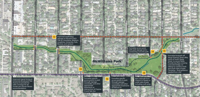
East Yale Avenue Corridor Study - DRAFT 22McWilliams Park
FIGURE 22 - MCWILLIAMS PARK RECOMMENDATIONS
Robert H. McWilliams Park, located immediately north of East Yale Avenue
between Clayton and St. Paul Streets, is a significant community asset. The
park boasts a soccer field, basketball court, and a playground (known as the
‘Dinosaur Playground’). The East Harvard Gulch Trail also travels through the
park from west to east, providing connections to Harvard Gulch Park to the
west and Colorado Boulevard to the east.
The park is one of several across the City identified for improvements through
the Elevate Denver Bond Program. In addition to needed repairs to the
concrete dragon (often misidentified as a dinosaur), an additional $550,000
in improvements focused on the picnic area and basketball courts are
planned.
The recommendations are mapped in Figure 22 with further details provided
in Table 4. Additional renderings and photographs are included in Figure 23.
East Yale Avenue Corridor Study - DRAFT 23TABLE 4 - MCWILLIAMS PARK RECOMMENDATIONS
PROJECT
RECOMMENDATION DESCRIPTION PROJECT TYPE KEY IMPLEMENTATION STRATEGIES POTENTIAL FUNDING SOURCES
ID
SHORT-TERM
Improved wayfinding/signage alternatives throughout the corridor could be
Improved wayfinding signage at the East
packaged together for more efficient design and installation. This recommendation
Harvard Gulch Trail at York, Josephine,
13 Wayfinding has a high return with minimal investment, broad community support, and meets the City general funds
Columbine, Madison, Monroe, and Jackson
Study’s multimodal improvement goals. See Figure 17 for wayfinding examples and
Streets
Figure 23 for potential locations.
Improved wayfinding/signage alternatives throughout the corridor could be
Formalize specific access points to
packaged together for more efficient design and installation. This recommendation
McWilliams Park through signage,
14 Bike/Ped has a high return with minimal investment, broad community support, and meets the City general funds
crosswalks, and other appropriate
Study’s multimodal improvement goals. See Figure 17 for signage examples and
treatments
Figure 23 for potential locations.
LONG-TERM
DPR is evaluating the feasibility of a low flow crossing consisting of a concrete bridge
Study the formalization the footpath off without a railing. This would provide a north and south connection across Harvard
Vassar Avenue and the possibility of low-flow Gulch while the nearest crossings exist at Fillmore Street to the west and South
15 Bike/Ped City general funds
crossing to connect the north and south Adams Street to the east. This option provides minimal return for the investment and
sides on the northeast edge of the Park would require floodplain evaluation and hydraulic and hydrologic analysis. Meets the
Study’s connectivity goals. See Figure 23 for more information.
This option would require significant capital investment to upgrade the signal if the
Upgrade the traffic signal at Yale & Fillmore signal is still within its life cycle. Potential drainage concerns arise with bulb out
Street and explore the addition of curb construction and would require inlets and/or cross-drains to not further impede
Vehicular/Bike/
16 extensions along the southern crossing of known drainage issues in the area. There are other options that could minimize the City general funds
Ped
Fillmore to shorten the crossing distance and crossing distance including flex posts. Pedestrian visibility improvements can be
improve visibility accomplished with increased summertime maintenance activities. Meets the
Study’s safety and connectivity goals. See Figure 23 for more information.
East Yale Avenue Corridor Study - DRAFT 24FIGURE 23 - MCWILLIAMS PARK RECOMMENDATIONS (# 13, 14, 15, AND 16) In addition to being a well-utilized community asset, McWilliams Park also serves as a transportation alternative for bicyclists and pedestrians by way of the East Harvard Gulch Trail. The recommendations proposed in and around the park including introducing wayfinding to additional points throughout the park as well other destinations along the Yale corridor (recommendation #13), formalizing access points into the park for safe and predictable path entrances (recommendation #14), and evaluating the potential for a second access point from the University Park neighborhood north of the park (recommendation #15). These recommendations all work towards the goal of both improving the East Harvard Gulch Trail and further encouraging park utilization. East Yale Avenue Corridor Study - DRAFT 25
Yale Way                                                                           FIGURE 24 - YALE WAY RECOMMENDATIONS MAP

East Yale Avenue becomes East Yale Way between St. Paul and Madison
Streets where the road takes a slight curve to the south. This segment of the
roadway poses pervasive safety issues for all modes, as a now sub-standard
buffered bike lane is present in addition to two general purpose vehicular
lanes (one in each direction). To add further complexity to the curve, there are
also elevation changes through this segment of the curve. These
recommendations are intended to address pervasive safety issues in this
section of the East Yale Avenue corridor. There is no line of sight in through
the Yale Way curve and vehicles frequently travel higher than the posted
speed limit. Recommendations for this focus area include:
The recommendations are mapped in Figure 24 with further details provided
in Table 5. Additional renderings and photographs are included in Figure 25.

 Cole Sukle, 14, was in the bike lane at East Yale and Madison Street
 when he was tragically killed after being hit by a car on July 13, 2016.
 Another teen, Jack Mahoney, was seriously injured in the crash.

East Yale Avenue Corridor Study - DRAFT                                                                                       26
TABLE 5 - YALE WAY RECOMMENDATIONS

PROJECT
             RECOMMENDATION DESCRIPTION                  PROJECT TYPE                           KEY IMPLEMENTATION STRATEGIES                                   POTENTIAL FUNDING SOURCES
  ID
SHORT-TERM
                                                                         Coordination within DOTI needed to identify the exact type of signage and/or speed
          Additional signage or speed alert to promote
                                                         Vehicular/Bike/ alert device to install and where. Has a high return with a minimal investment, has
  18      speed-calming measures throughout the                                                                                                                City general funds
                                                         Ped             broad community support and meets the Study’s safety improvement goals. See
          curve
                                                                         Figure 25 for speed alert signage examples.
DID NOT PROCEED PAST ALTERNATIVES ANALYSIS
          Improved signage to address reduced line of    Vehicular/Bike/
  17                                                                     N/A                                                                                   N/A
          sight in the roadway curve                     Ped

    East Yale Avenue Corridor Study - DRAFT                                                                                                                                         27
FIGURE 25 - SPEED ALERT EXAMPLES
Radar based speed displays
similar those shown here are highly
effective in notifying drivers to slow
down in areas of high-speed
concern. Also known as driver
feedback signs, these traffic
calming devices display the speed
of the passing vehicle and
sometimes include flashing light
bars. Signs of this type would be
effective in calming traffic speeds
approaching the curve at Yale Way
and potential bicycle and/or
pedestrian conflicts near
McWilliams Park and the East
Harvard Gulch Trail. These signs
are not equipped with cameras or
ticketing capabilities – they are
purely intended to reinforce the
existing speed limits and work with
drivers to create a safer travel
environment.
East Yale Avenue Corridor Study - DRAFT 28Yale & Colorado Intersection
FIGURE 26 - YALE & COLORADO RECOMMENDATIONS MAP
The intersection of East Yale Avenue and Colorado Boulevard consists of East
Yale Avenue intersecting with Colorado Boulevard in two different places –
the southern intersection about 275 feet south of the northern intersection.
This disconnected intersection, requiring travel through two signalized
intersections, poses safety and traffic efficiency issues with through travel on
East Yale Avenue.
The southern intersection has numerous civic facilities located immediately
adjacent, including the University Hills YMCA, Mercy Street Reformed Church,
and Denver Fire Department Station 24. The signals at this intersection were
recently modified to include a leading pedestrian indicator (LPI) which gives
pedestrians and cyclists the opportunity to enter the intersection 3-7 seconds
before vehicles are given a green light. With this head start, pedestrians can
better establish their presence in the crosswalk before vehicles have priority
to turn. The northern intersection has BikeSource, Schlessman YMCA,
University Hills Shopping Center, and University Hills Plaza immediately
adjacent to the intersection.
Both the northern and southern portions of the intersection need
reconstruction for maintenance purposes.
These recommendations are focused on improving safety and efficiency in
and around the intersection of Yale & Colorado Boulevard. As shown in the
existing conditions report (and known throughout the community), this
intersection has a hazardous history of vehicle, pedestrian, and bicycle
crashes. Additionally, the dual signal jog poses operational complexities that
were further analyzed through the Study’s VISSIM analysis, the results of
which are available in Appendix E.
The recommendations are mapped in Figure 26 with further details provided
in Table 6. Additional renderings and photographs are included in Figures 27
– 30.
East Yale Avenue Corridor Study - DRAFT 29TABLE 6 - YALE & COLORADO RECOMMENDATIONS
POTENTIAL
PROJECT
RECOMMENDATION DESCRIPTION PROJECT TYPE KEY IMPLEMENTATION STRATEGIES FUNDING
ID
SOURCES
SHORT-TERM
Continued coordination between DOTI and CDOT to ensure smooth installation efforts as this
Install a dedicated left turn signal from northbound City general funds,
19 Vehicular project is already in the works within DOTI. This recommendation provides only vehicular
Colorado Boulevard to westbound Yale Avenue. CDOT funds
efficiency benefits. Meets the study’s safety goals. See Figure 29 for more information.
Improved wayfinding/signage alternatives throughout the corridor could be packaged
Provide structural and educational wayfinding
together for more efficient design and installation. This recommendation has a high return with
improvements to connections along Yale, to key
20 Wayfinding minimal investment, broad community support, and meets the Study’s multimodal City general funds
activities centers (i.e. YMCA, DFD Station), and
improvement goals. See Figure 17 for wayfinding examples and Figures 28 and 29 for
through retail centers and commercial developments
potential locations.
City general funds,
Install an LPI and bike detection at Amherst Avenue Coordination between DOTI and CDOT recommended to ensure smooth installation. This
Community
and Colorado Boulevard (to be installed in recommendation has independent utility and can be installed outside of Recommendation #6
Transportation
21 conjunction with a future bikeway on Amherst). LPIs Bike/Ped (Amherst Bike Facility) due to pedestrians and cyclists using this intersection as a bypass to
Network (CTN)
are intended to be installed at all approaches to the the Yale & Colorado intersection. Meets the Study’s safety, connectivity, and multimodal
Program (future),
Colorado & Yale intersection. goals. See Figure 19 for more information.
CDOT funds
Rebuild the traffic signal and both existing triangular
The signal poles have obvious state of good repair concerns and are in poor condition with
raised islands at the northern intersection to improve
visible rust. Reconstruction of these poles can also include both LPI deployment across both City general funds,
signal timing for pedestrians and provide a safer and
Vehicular/Bike/ crosswalks at this intersection and a potential reconstruction of the “porkchops” (pedestrian CDOT funds, Safer
22 more comfortable crossing. This rebuild is also
Ped and bicyclist refuges). This recommendation has broad community support and meets the Main Street grant
intended to relocate the signal pole on the west side
Study’s safety improvement goals. Coordination between DOTI and CDOT recommended to program (DRCOG)
of Colorado Blvd to provide a clear walkway and
ensure smooth design and installation efforts. See Figure 31 for more information.
space for pedestrians to queue. (Figure 16)
Explore a partnership with the YMCA to help facilitate this connection. Improved
wayfinding/signage alternatives throughout the corridor could be packaged together for more
Improve wayfinding to route people from the Harvard
24 Wayfinding efficient design and installation. This recommendation has a high return with minimal City general funds
Gulch Trail across Colorado Boulevard.
investment, broad community support, and meets the Study’s multimodal improvement goals.
See Figure 17 for wayfinding examples.
MID-TERM
Address free right turns that impede safe crossings Coordination between DOTI, CDOT, and the Denver Fire Department is recommended to ensure
with signal improvements and/or a no right turn cycle smooth planning, design, and installation of any signal or intersection modifications,
Vehicular/Bike/ City general funds,
23 in the northern intersection. There is a potential for a including the potential for raised crosswalks. Design efforts should also account for any
Ped CDOT funds
raised crossing to further slow turning movements potential drainage issues at the intersection and the impact constructing raised crosswalks
and tighten the turning radius. would have. Meets the Study’s safety goals. See Figures 29 and 30 for more information.
East Yale Avenue Corridor Study - DRAFT 30You can also read