Trend of urban growth in Nepal with a focus in Kathmandu Valley: A review of processes and drivers of change - Netra Prasad Timsina, with input ...
←
→
Page content transcription
If your browser does not render page correctly, please read the page content below
Trend of urban growth in Nepal with a
  focus in Kathmandu Valley: A review of
          processes and drivers of change

Netra Prasad Timsina, with input from Anushiya Shrestha,
              Dilli Prasad Poudel and Rachana Upadhyaya

                 Tomorrow’s Cities Working Paper 001
                                                August 2020

                           1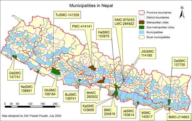
About Tomorrow’s Cities

"Our mission is to reduce disaster risk for the poor in tomorrow’s cities."

Tomorrow’s Cities is the UK Research and Innovation (UKRI) Global Challenges Research
Fund (GCRF) Urban Disaster Risk Hub – a five-year global interdisciplinary research hub.

Our aim is to catalyse a transition from crisis management to multi-hazard risk-informed
and inclusive planning and decision-making, for cities in low-and-middle income
countries.

Globally, more than two billion people living in cities of low-to-middle income countries
are exposed to multiple hazards such as floods, earthquakes, landslides, volcanoes and
fires, which threaten the cyclical destruction of their lives and livelihoods. With urban
areas expanding at unprecedented rates, this number is expected to reach four billion by
2050.

Failure to integrate multi-hazard disaster risk into urban planning and decision-making
presents a major barrier to sustainable development, including the single greatest global
challenge of eradicating poverty in all its forms.

But this global challenge is also major opportunity: as ~60% of the area expected to be
urban by 2030 remains to be built, we can reduce disaster risk in tomorrow’s cities by
design.

We are one of 12 UKRI GCRF Hubs funded by a UKRI Collective Fund Award, as part of
the UK AID strategy, putting research at the heart of efforts to deliver the United
Nation’s Sustainable Development Goals (SDGs).

www.tomorrowscities.org
@UrbanRiskHub
The UKRI GCRF Urban Disaster Risk Hub
ECCI High School Yards, Infirmary Street, Edinburgh EH1 1LZ

                                                  2
Abstract

This report documents and discusses the urbanization trend, spatial transition, major drivers of
urban change, and existing institutional mechanisms of urban development in Nepal , one of the
top ten fastest urbanizing countries in the world. Particularly, it reflects on the gaps and
challenges for urban governance in Nepal and focuses on Kathmandu Valley, the “hub” of
urbanization in Nepal. The urban population growth rate in Nepal almost doubled from 3.6% in
1991 to 6.5% in 2001, and the number of urban centers increased from 58 in 2013 to 293 in
2017. The review shows the transition of Nepal from predominantly rural to an emerging urban
economy is primarily the result of the governmental decisions that merged rural administrative
units and designated them as municipalities, administratively the urban units of Nepal. Rural to
urban migration is another important factor driving urban growth in Nepal. Unplanned land use,
shrinking open spaces, haphazard construction, and poor services have become major urban
features of Nepal, which resemble the growth of Kathmandu Valley.

Kathmandu Valley, with an estimated population of 2.54 million, is growing at 6.5% per year,
indicating one of the fastest-growing metropolitan areas in South Asia. Haphazard and
unplanned urbanization of the valley have degraded the urban environment, increased urban
poverty, and exposed the growing urban population to multi-hazard risk. Aiming to balance
urban development, develop disaster-resilient cities and enhance urban resilience, the
government has formulated the urban development strategy and declared new programs for the
development of emerging urban centers and “smart” cities in the valley. However, such centrally-
planned infrastructure development activities lack coordination and contradict the formal policy
intentions, and are facing resistances in some places, rendering their implementation uncertain.
The majority of the urban population lacks resiliency and the government lacks institutional and
financial capacities and coordination crucial for undertaking inclusive, equitable, and resilient
urban development. The current constitutional provision that restrains the government from
imposing any kind of restriction on the use of private property has come up as an additional
impediment to urban governance in Nepal and thus making urban areas increasingly disaster-
prone and the urban population, primarily the urban poor, vulnerable to multiple hazards.
Kathmandu Valley has become an evidence of these processes and their ramifications. The
report has concluded by providing key insights that can be useful in making tomorrow’s cities
inclusive, equitable, and resilient.

                                               3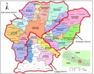
Table of Contents

1.       Background information ........................................................................................................................ 6
2.     Trend of urbanization ............................................................................................................................. 8
     2.1 Spatial transition ................................................................................................................................... 8
     2.2 Forms of urbanization.......................................................................................................................... 9
3.       Policy and Institutional landscape of urban development in Nepal .......................................... 10
     3.1 Policies and institutions .................................................................................................................... 10
     ....................................................................................................................................................................... 14
     3.2 Periodic development plans and urban development ................................................................ 14
     3.3 Smart City- a new approach for managing urban development .............................................. 16
4.       Urban resilience building and disaster risk management ............................................................. 18
5.     Trend of Urban growth in Kathmandu Valley ................................................................................ 20
     5.1 Level of growth of Kathmandu Valley ........................................................................................... 20
     5.2 Land use changes in Kathmandu Valley ........................................................................................ 22
6.     Drivers of urban growth ...................................................................................................................... 23
     6.1 Economic Opportunities ................................................................................................................... 23
     6.2 Road networks, development infrastructure and services ....................................................... 24
     6.3 Land Market......................................................................................................................................... 25
     6.4 Political factor ..................................................................................................................................... 25
7.       Discussions ............................................................................................................................................. 26
8.       Conclusions............................................................................................................................................. 28

                                                                                      4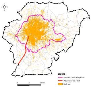
Abbreviation

      ADB       Asian Development Bank

      CBS       Central Bureau of Statistics

      DoHC      Department of Housing and Construction

      DoLRM     Department of Land Reform and Management

      DoR       Department of Roads

      DUDBC     Department of Urban Development and Building Construction

      GDP       Gross Domestic Product

      GoN       Government of Nepal

      ICT       Information and Communication Technology

      KMC       Kathmandu Metropolitan City

      KUTDC     Kathmandu Valley Town Development Committee

      KV        Kathmandu Valley

      KVDA      Kathmandu Valley Development Authority

      LMC       Lalitpur Metropolitan City

      MoFAGA    Ministry of Federal Affairs and General Administration

      MoUD      Ministry of Urban Development

      NLSS      National Living Standard Survey

      NPC       National Planning Commission

      NUDS      National Urban Development Strategy

      TDF       Town Development Fund

      UCDI      Urban Corridor Development Initiatives

      UN DESA   United Nations Department of Economic and Social Affairs

      VDC       Village Development Committee

      WSSC      Water Supply and Sewerage Corporation

                                  5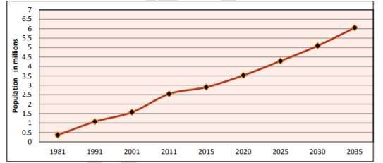
Trend of urban growth in Nepal with a focus in Kathmandu Valley: A
Review of processes and drivers of change

RQ1: What are the drivers and types of change in urban form, governance, investment and
demographics that are currently occurring or planned in the Kathmandu valley?

    1. Background information
Nepal is one of the least urbanized countries of Asia but rapid urbanization in the last decades
has been observed as a result of multiple urban transitions (spatial, demographic and economic)
that are underway. It is one of the top ten fastest urbanizing countries in the world (UNDESA,
2014). According to Montgomery et al., 2004, an urban transition is a process of shifting
population from rural settlements where population is small and dispersed in which agriculture is
the dominant economic activity towards one where the population is concentrated in larger,
dense urban settlements characterized by industrial and service activities. Urban centers are the
centers of economic activities that tend to be associated with enhanced productivity. Industries
and services are usually concentrated within urban areas that attract businesses and workers
(both skilled and unskilled).

The urban transition and economic growth are interlinked as economic development fuels
urbanization. People are attracted to cities that offer varied opportunities for education and
employment, particularly in the manufacturing, construction and services sectors. Cities attract
diverse forms of labor that economy needs in order to grow. As hubs of business and trade,
government, and transportation, cities provide crucial links with rural areas, between cities, and
across international borders. Urban economy contributes the largest share to the national
economy. Nepal’s urban areas contribute about one-third of the national GDP. Estimate of the
contribution of urban areas to national GDP of Nepal is 33.1% (CBS, 2012). The contribution of
Kathmandu Valley to the GDP has been estimated by the Central Bank to be 23.4% of the
national GDP (MoUD, 2017).

The growth of the urban population for the last decade has been very fast due to both political
and economic reasons. Until 2013, only 17.1% of Nepal’s population resided in 58 designated
urban areas (UNDESA, 2014). However, with the addition of 159 municipalities in 2014/ 2015,
now, 40% of Nepal’s population resides in 217 designated urban areas (MoUD, 2017).
Furthermore, in 2017, the Government of Nepal decided to implement a major territorial reform
based on constitutional provision through the Local Level Restructuring Commission (LLRC) after
promulgation of new Constitution of Nepal in 2015. The commission has recommended a total
of 753 local level units, of which 2931 are declared as urban units (6 Metropolitan Cities, 11 Sub-
Metropolitan City and 276 Municipalities) that comprises 56.5% of the urban population (16.5
million) of total population of Nepal (29.1 million) as of 2019 (CBS, 2019)2. There have been
fluctuations in inter-censual urban growth rates. One of the reasons for drastic change in the
percent of population in Nepal who live in urban areas over short period of time is due the
1 The Cabinet decision and declaration of 72 new municipalities on 8th May 2014, 61 new municipalities on 2nd
December 2014 and additional 26 new municipalities on 18th September 2015 reflects GoN’s policy to prioritize
urban development. As of 2015, 22% of the total urban population of the country was within Kathmandu Valley KVDA
(KVDA, 2015, p7-2). Later in 2017, the Government has restructured the local government with 293 urban units out of
753 local governments (Palikas).
2
  https://cbs.gov.np/wp-content/upLoads/2019/07/Nepal-ko-Tathyankiya-Jhalak-2076.pdf (Glimpse of Nepal’s
statistics)
                                                        6
political decision of the government converting rural administrative units to urban administrative
units (Municipalities).
Although the growth rate in the inter-censual decade was 3.43%, the average annual growth
between 1981 and 2011 has remained at a high rate of 5.3%.3 Urban rural growth differential in
2011 was 2.4% (MoUD, 2017). In 2014, the level of urbanization was 18.2 per cent, with an
urban population of 5,130,000, and a rate of urbanization was 3 per cent (UN DESA, 2014). The
same report forecasts that for the period 2014- 2050, Nepal will remain amongst the top ten
fastest urbanizing countries in the world with a projected annual urbanization rate of 1.9%.i
33.5% of the urban population is concentrated in 16 urban centers that each has a population of
over 100,000 people (MoUD, 2017). The Central Development Region4 (now Bagmati Province)
has the highest proportion of the urban population, followed by the Eastern (Province 1) and
Western Development (Gandaki Province) Regions. The distribution of the urban population is
relatively low in the Mid-Western (Karnali Province and Far Western Development (Far Western
Province) Regions (MoUD, 2017).5
Map 1: Municipalities in Nepal with population above 1,00,000 (Metropolitan and Sub-
metropolitan cities)
3 MoUD, 2017
4 The statistics about the urban population belong to the pre-state restructuring situation and hence former five
administrative development regions are mentioned in the text.
5 http://www.gsdrc.org/wp-content/uploads/2015/11/HDQ1294.pdf
7Urbanization is gaining pace in other cities of Nepal. However, Kathmandu Valley continues to
be the “hub” of urban development in Nepal (MoUD, 2017). Various plans for urban
development of Kathmandu Valley have been formulated at different times. Implementation of
these, however, has largely been poor (KVDA, 2015). Unplanned urbanization in the valley
continued engulfing the agricultural lands, adding several physical, social, and environmental
problems in the Kathmandu Valley and also significantly increasing vulnerability to disasters,
including earthquakes (Muzzini and Aparicio, 2013; Khanal et al., 2017) and urban flooding,
among others (KVDA, 2015; Pradhan-Salike and Pokhrel, 2017).6 More recently, the government
is aiming to control urban sprawl and plan the urban expansion in Kathmandu Valley through
multiple projects such as satellite cities, smart cities, outer ring road, fast-track etc. The National
Urban Policy of 2007 states that “Kathmandu-centric urbanization is a major cause for the
imbalance in national urban structures” (MoPPW/DUDBC, 2007: 1). It is yet to see how these
ambitious projects change the pace and process of (unplanned) urbanization in this rapidly capital
regional and the imbalance in the national urban structures of the country. However, such
multiple projects have already given rise to opposition from the local residents and landowners
who claim such projects will displace them and destroy the socio-cultural identities; resistances
against multiple projects planned in Khokana, our study site, is an example.7
This report is prepared based on secondary literature. The report will first discuss on the trend of
urbanization in Nepal with a focus on spatial transition and forms of urbanization. Then it will
look at on the policies and institutions along with the focus of the periodic plan of Nepal starting
from the first plan (156-1961) to the latest fifteenth plan (2019-2023). The concept of smart city
in general in Nepal and in particular in Kathmandu Valley is also discussed in the report. The
report also reviews the policies and practices of urban resilience and disaster risk management
followed by urban transition of Kathmandu Valley along with the land use changes. The report
has also discussed major drivers of urban change in Nepal and summarized the major issues to be
addressed in relation to urbanization and urban governance.
2. Trend of urbanization
2.1 Spatial transition
Nepal’s demographic transformation is characterized by fast-growing population density in major
cities, along the main highways, and close to the border with India. While overall population
growth has slowed since 2001, urban population growth has kept its pace at 3.4% per year from
2001 to 2011, compared with 3.6% per year from 1991 to 2001 (reclassification—that is, the
conversion of rural areas to urban areas—excluded). Kathmandu Metropolitan City—the only
urban center in Nepal with a population above 1 million—is growing at 4.0% per year, medium
cities (100,000– 300,000) at 3.5%, and small cities (50,000–100,000) at 3.6%. Pokhara in the
Central Hills is the largest and fastest-growing medium city, with growth above 5% per year.
Three medium cities have also sustained population growth in excess of 4% per year: Bharatpur
(148,000) in the Central Tarai, Butwal (120,000) in the Western Tarai, and Dhangadhi (104,000)
in the Far Western Tarai. A number of small urban growth centers are emerging along the main
highways of the country and close to the border with India. The fastest- growing urban
settlements, with populations below 100,000 and growth in excess of 4%, include Damak and
Itahari (Eastern Tarai); Banepa (Central Hills); Byas and Tansen (Western Hills); Gorahi and
Tulsipur (Midwestern Tarai); and Birendranagar (Midwestern Hills) (CBS, 2001 and 2012).
The conversion of rural space into urban space is an important contributor to urban growth. The
urban population growth rate from 1991 to 2001 almost doubles from 3.6% to 6.5% (MoUD,
6
https://thehimalayantimes.com/kathmandu/flood-alert-issued-inside-kathmandu-valley/
7 https://www.setopati.com/social/210999
82017). However, Muzzini and Aparicio (2013) argue that in practice, the spatial transformation is
not fully captured by the politico-administrative definition of urban areas. On one hand, a
number of emerging towns with urban like characteristics continue to grow. On the other hand, a
number of urban settlements contain large areas of land with rural characteristics. The
disconnect between urban geography and the politico-administrative definition of urban areas is
the result of Nepal’s legal definition8 of urban settlements overemphasizing the role of
population size, while assigning little weight to other urban criteria, such as essential facilities-
infrastructure and services required for urban areas.
The merging and remerging of the Municipalities and VDCs was also the political decisions
where many of the rural VDCs were converted into Municipalities. As argued by Muzzini and
Aparicio (2013), the reclassification of rural into urban areas is an important reason to increase
the number of urban units over short period of time (2013-2016). Moreover, the economic
incentives that brought by the construction of new roads and highway in different geographic
regions of Nepal have resulted into the increased number of towns and market centers in the
country.9 Nepal’s urban population has increased to 17% in 2011 from 13.9% in 2001. Urban
population became 38.25% in 2016 and 56.5% in 2017 (CBS, 2019)10. But, as mentioned above,
many of them are urban by law, which is rendered so through the declaration of a certain
territory as a “municipality” by the government on 10 March, 2017. Nepal has undergone
momentous state restructuring after the promulgation of new constitution in 2015. Some rural
areas are redefined as urban (as municipality) without the basic services, amenities and
opportunities that are commonly anticipated in urban areasii.
The rapid increase in number of economically active population in rural areas, their improved
literacy status and rising aspiration for employment in the non-agricultural sector has increased
the rate of rural to urban migration in Nepal. Urban population growth rate in Nepal is 3.38%
where rural and total population growth rates are measured at 1.03 and 1.4 respectively in 2011
(CBS, 2011). The government has provided attention of urban development through new town,
smart city, satellite city and mega city development under the Ministry of Urban Development
(MoUD), Department of Urban Development and Building Construction (DUDBC)iii. Recently,
government of Nepal is executing planned intervention in the Tarai Towns of Nepal, particularly
in the growing potential towns of Tarai-Madhesh Region. The main objective of developing new
towns in Tarai-Madhesh Region is to balance urban development and develop livable cities in
Tarai-Madhes area of Nepal so that stagnant areas would be economically active and connected
by the newly developed towns of the Tarai-Madhes region (DUDBC, 2018; MoF, 2016).
Natural expansion of urban area due to increased population growth and newly established
planned cities put high pressure in the limited resources available in the cities. Water scarcity,
solid waste management and lack of other basic amenities are the major problems faced by most
urban areas in Nepal.
2.2 Forms of urbanization
In many of the cities in Nepal, urban forms are becoming increasingly disorganized. Unplanned
land use, shrinking open spaces and haphazard construction with low quality services have been
the major urban forms till recent past (KVDA, 201; MoUD, 2017). This has affected both social
8 An area having a population of 300,000 and an annual income of Rs. 400 million can be declared a metropolitan
city. Similarly, a sub-metropolitan city should have 100,000 people and Rs. 100 million annual incomes. Similarly, in
Tarai region, municipalities can be created if they have 20,000 people and Rs. 5 million annual incomes. In the hills
and mountains, a village having 10,000 people and a Rs. 500,000 annual incomes are needed to be declared a
municipality.
9 https://www.nepjol.info/index.php/TUJ/article/view/25346/21219
10
https://cbs.gov.np/province-statistics/ accessed at 9 April 2020.
9and cultural environment in both existing and emerging cities.
The traditional core area of city consisted of densely built area comprising of narrow streets. In
newly emerging cities these cores are found to be almost non-existent. In the new cities which
are built along the highway, the core is formed as ribbon development on both sided of the
highway. Small cities have single core, however, large urban centers have multiple cores
particularly with the metropolitan and sub-metropolitan cities. The urban expansion is happening
from the center to periphery along the connector road that has branched out from the highways.
The high density of the core is found to be gradually shifting towards periphery surrounded by a
vast expanse of agriculture dominated rural area.
The traditional core areas are quickly occupied by the newly built multi-story concrete buildings
(particularly, after the earthquake of 2015). These multi-story buildings are occupied either by
multiple families or by businesses and offices. In the large cities, the land use functions are
becoming specific and specialized. Banks and financial institutions have now come to locate at
the center, while businesses have come to locate in its surrounding—especially along the key
arterial roads (MoUD, 2017). Consequently, parking and congestion have come to be critical
concerns at the core.
In contrast, there is a consistent trend that the residents of core are shifting to periphery and
settled in single family detached residential building (MoUD, 2017). There are a number of
reasons for this trend of shifting from core to periphery as in some cases properties at core are
sold due to family separation, in some other cases properties are rented and/or sold as the core
areas have commercial values. In majority of the cases, the middle class of the city wanted to
have detached residential building in less crowded places and hence they shift to detached
housing areas developed by real estate. Some of them keep their property intact in core area as
they lend in rent and a few sell their properties. As a result, large areas of agriculture land are
occupied by real estates. The access is found to be irregular. Provisions of essential services such
as waste management, availability of clean and safe drinking water are also limited.
3. Policy and Institutional landscape of urban development in Nepal
3.1 Policies and institutions
Government of Nepal undertook planned resettlement and urban development programs from
the first (1956-1961) to the sixth (1980-1985) period national plans especially in the southern
Tarai region of Nepal (Adhikari and Dhungana, 2010). These programs largely benefited those
who were close to the ruling elites, and with passage of time, gradually gave way to an
autonomous urban sprawliv. The subsequent national plans also promoted policies and programs
for developing the urban areas in Nepal. The Town Development Act 1988, Local Self-
Governance Act 1999, National Housing Policy 1996, National Urban Policy 2007 and the most
recent National Urban Development Strategy 2017 (NUDS 2017) have been the major policy
documents for urban development. National Shelter Policy 1996 was enacted to support slums
and squatters to provide them housing support.
The National Urban Policy of 2007 seeks to promote a balanced national urban structure, a
clean, safe, and well developed urban environment, poverty reduction; and effective urban
management by capable local institutions. The policy has also prioritized access of the urban
poor to low-cost housing, housing finance, and income-generating activities and also
development in excluded regions.
The NUDS 2017’s investment strategy stipulates that at least two per cent of GDP will be
allocated for urban infrastructure investment between 2015 and 2030. Strategies include a
coordinated investment in urban areas involving all sectorial agencies and the private sector. The
10strategy also proposes increased investment in the mid and far west development regions, in
underdeveloped regions of inner Tarai and southern Tarai. Though different Acts and
Regulations such as Town Development Act-1988 and Local Self Governance Act-1999 and
related regulations were promulgated with stakes in urbanization, periodic national plans were
the main basis of urban development in Nepal (see section 3.2).
The Town Development Fund (TDF) was established in 1989 as an autonomous financial
intermediary for providing funds to municipalities. TDF has financed a wide range of urban
infrastructure projects in municipalities with the support of the government, GIZ, the World
Bank and the ADB. It has recently created an open access fund where municipalities can bid for
funding on a competitive basis (ibid.)v.
Ministry of Urban Development (MoUD) and Department of Urban Development and Building
Construction (DUBDC) implement urban development plans and programs whereas the Ministry
of Federal Affairs and General Administration (MoFAGA) is responsible for administering the
programs. The MoFAGA is involved in the administrative and personnel management functions
of the local government, but it has no mandate to assist in the preparation of physical
development plans of municipalities for which it has to rely on DUDBC.
Various national and local institutions are involved in developing settlements and urban
development activities of Kathmandu urban areas and the Valley as a whole. Apart from the
institutions mentioned above, there are several central government agencies working in
Kathmandu Valley. They are the Department of Land Reform and Management (DoLRM),
Department of Housing and Construction (DoHC), Kathmandu Valley Town Development
Committee (KVTDC), which was replaced by Kathmandu Valley Development Authority (KVDA)
in 2012, Department of Roads (DoR), Water Supply and Sewerage Corporation (WSSC) etc.
There is a lack of cooperation and coordination between these institutions for effective planning
and implementation of urban infrastructure development activities. Inherent conflict and
contradiction in mandate, autonomy and jurisdiction of the institution related to urban
development are through the overlapping and uncoordinated functions of the institutions.
According to the Local Self-Governance Act 1999, the constitution of Nepal and the Local
Government Operation Act, the local governments are responsible to formulate and implement
land-use plan within their administrative boundary. They are also responsible to issue the
building permit and monitor the implementation of the building permits. Preparing land use plan
and enforcing the building bylaws are also among the responsibilities of the district town
planning offices (TPO). Duplication of these responsibilities between the local governments and
the TPO has undermined the enforcement of the by-laws while formulation of land use plan has
remained almost absent. Besides the lack of capacity of local governments, issuing the building
permit being the source of revenue for local governments, they often issued building permits
even when the buildings violated the by-laws or communal buildings were constructed on open
public land (see Karki, 2004). Not only cheaper land, but also weak enforcement of building
permit requirements in the peripheral villages of Kathmandu Valley motivated migrants to settle
there (ICIMOD, 2007). The repercussion is the rapid expansion of urban sprawl transforming
rural areas (or fringes) into urban form without adequate infrastructure to support development.
Such haphazard urban expansion is also widespread in the risk prone areas such as flood plains
and steep slopes. Enforcing building bylaws, penalizing violators and demolishing illegally
constructed buildings are important, yet controversial and equally risky interventions as
evidenced in the history of urban planning in Nepal. This continues till date, which has made
KVDA and its urban planning approach and activities prone to oppositions and the legitimacy of
11KVDA challenged by the elected local governments. For example, Kathmandu Valley
Development Authority (KVDA) supersedes and undermines the rights and autonomy of the
Municipalities if it comes under the development of large infrastructures in the respective
municipalities in Kathmandu Valley (KV). Many plans such as the plan of smart cities, high way
and ring roads in KV were developed without considering the role of local municipalities and
hence there are numbers of resistances coming from the local governments themselves against
the infrastructures to be built. The institutions directly and indirectly linked to urban planning at
the federal level and KV are given in the figure 1 below. Province and local governments are
independent entities and they have their own institutional arrangements for planning urban
development.
12Kathmandu Valley
Development Auuthority
(KVDA)
Department of Urban
Development and Buiding
Construction
Town Development Fund
Organizations
Rastriya Awas Company
Ltd.
Ministry of Urban
High Powered Committee
Development
for Integrated
Developenment of
Bagmati Civilization
Physical Infrastructure
Section
Inter-provincial
Urban Development
Development Plan
Division
Coordination Section
Urban Infrastrucutre
Devellopment Section
GoN Planning and Monitoring
Section
Planning and Development
Ministry of Federal Affairs
Fund Coordination
and General Administration
DIvision
Development Aid
Coordination Section
Land Improvement and
Land Management
Settlement Management
Division
Section
MInistry of Land
Development, Cooperatives
and Poverty Alleviation
Surveying and Mapping,
Planning , Monitoring and
Land Information and Land
Evaluation Division
Use Section
Ministry of Physical
Department of Roads
Infrastrucutre and Transport
Figure 1. Key Bureaucratic Entities for Urban Development
13The Local Government Operation Act, 2017 provides fiscal autonomy to the local governments
(Metropolitan cities/sub metropolitan cities, municipalities and rural municipalities). Revenue
generated through local government is the main source of their development budget. The figure
below illustrates the process of preparation of development plans of local governments. The
federal and provincial ministries implement national level development projects that transcend
the administrative boundaries. Therefore, such ministries have a designated section to
coordinate with the local governments. However, there are gaps and overlaps in institutional
linkages and coordination.
Municipal Assembly
Federal and
Provincial Guidelines
based on National
Approval Development
Priorities
Annual Municipal
Development Plans
Seven Steps Planning Process of the Local
Governments
Figure 2. Local Level Development Planning Process
3.2 Periodic development plans and urban development
Nepal Government started its planned effort for urban development since 1944. Eradication of
malaria in Tarai region and the construction of east-west highway,11 expedited migration from
mountain and hilly regions to Tarai after 1950 in Nepal found to be driving factor for developing
cities and towns in the Southern border of Nepal (Adhikari and Dhungana, 2010). First periodic
plan (1956-1961) has initiated the resettlement and government housing policy in Tarai region of
Nepal and that has promoted migration from Hills to Tarai region resulting into the growth of
towns. Expansion of bureaucracy and military sector and trade of imported goods to the peri-
urban centers are considered to be the factors that promoted urbanization in the mid hills
(MoUD, 2017).
Nagar Panchayat Act 1962 (Municipality Act) was enacted during the second plan period (1962-
11 East-west highway, as the name suggest runs throughout east of Nepal to the west. It is 1,027.67 k.ms. in length.
141965). Plan for the construction of the East-West highway and Kodari highway (linking to China)
in this planning period were major milestones to the development of towns in Tarai and Mid-hills
in Nepal. Third plan (1965-1970) incorporated the regional development policy in Nepal. Town
planning and building constructions in the regional headquarters was also the target of this plan.
Fourth plan (1970-1975) has mentioned the housing plans for new settlements prepared in the
areas delineated in the master plan for physical planning in places that have commercial and
industrial importance like Pokhara, Biratnagar, and Birgunj. It was aimed to help develop urban
areas in a planned way and by a coordinated regional approach during the fourth plan. Fifth Five
Year Plan (1975-1980) came up with regional planning objectives that had promoted the urban
centers in the regional headquarters of the country. Seventh plan (1985-1990) has incorporated
the concrete vision of urbanization and habitat policy by emphasizing development of urban
centers along the East-West highway and in the corridors that link the north and south of the
country (NPC 1985, Seventh Plan, page 227-234). This plan aimed to properly manage
urbanization, create opportunity for productive employment and increase income to develop
urbanization as a supplement to rural development based on a multi-sectorial approach. Private
sectors were also encouraged towards urban development in this plan. Town Development Act
1988 was enacted in the same plan period. In the existing laws relating to town development
were replaced by municipal development law (1988/89). The Kathmandu Valley Development
Authority Act 1988 was also prepared to expedite the development of the valley through an
authoritative body. The government also provided loan assistance to some Municipalities for
implementing the land development programs.
During Transitional Phase12 (1990-1992), institutional arrangements such as establishment of
Ministry of Housing and Physical Planning, Ministry of Local Development as well as the
formation of their line departments were made to promote the urbanization. Separate acts for
local bodies along with the Municipality Act were enacted in 1992. The Ninth plan (1992-1996)
not only recognized the growth in urbanization in Nepal as the expansion of physical facilities,
but also regarded it as a major contributor to the national economy. For this purpose, emphasis
was given on the implementation of urban development program with strong participation of the
private sector. The Tenth plan (2002-2007) further recognized the urban centers to be the
backbone of economic growth and catalyst for change in the country. The plan took an approach
of replicating the urban development activities to the rural areas that led to the development of
a number of urban centers in different regions of Nepal. Mobilization of means and resources
from private sector and the local bodies for the construction, operation and management of
urban infrastructure was strategized in the tenth plan. In 2007, the Government of Nepal
enacted National Urban Policy for balanced urban development in Nepal (DUDBC, 2007). The
policy aims to develop balanced urban growth in the country by prioritizing investment to the
regions for development of regional cities and intermediate towns.13 Digital maps of all
municipalities, healthy city program, urban environment improvement project and environmental
improvement were also emphasized in this plan. Urban-rural linkages were largely emphasized in
the tenth plan.
The Eleventh Plan (2007-2010) has stipulated its objective of urban development under the
overall notion that urban development promotes rural development. It aims to invest in urban
infrastructure and other services through inter-agency coordination to build a clean, safe and
12 The period is called transitional phase because in this period through People’s Movement-I (mass uprising) the
absolute monarchy was replaced by multiparty constitutional democracy.
13
https://www.nepjol.info/index.php/TUJ/article/view/25346/21219
15prosperous urban environment, and to progressively guide rural settlements towards
urbanization by expanding rural-urban inter-relationship14.
The Twelfth Plan (2011-2013) aimed to develop secured, clean and economically dynamic cities
with basic facilities needed for cities. It also intends to maintain a balanced national urban form
through-out the country. It included 25 small cities to be developed in this period and 10 cities
in the hills particularly in the corridor of mid-hills highway15.
The Thirteenth Plan (2013-2016) has continued the policy and strategy of urban development
adopted by the twelfth plan such as developing small, medium and large scale cities across the
country to accelerate the economic growth through providing employment opportunities and
economic incentives. Involvement of private sector in urban development was emphasized in this
plan16.
Under the balanced regional development, the Fourteenth Plan (2017-2019) envisioned the
development of small towns around the peri-urban areas to minimize the pressure on urban
areas. This plan has aimed to establish secure and economically balanced cities with required
basic urban facilities.17 The same plan came up with a concept of “one city, one identity” in order
to establish uniqueness of each city. Likewise, the plan stipulates that some of the selected cities
will be developed under the criteria of “Smart Cities” and some are developed as “Food Green
Cities”18.
The Fifteenth Plan (2019-2023) approach paper aims to achieve sustainable economic and social
development through urbanization. Moreover, the plan has set objectives of developing disaster
resilient, human centered, economically dynamic, hygienic and clean and well managed cities in
the country. It also focuses to develop balanced national urban system and improved urban
structure. It also promotes urban-suburban inter-linkages and green economy in the cities to be
developed. The approach paper also highlights the institutional development of urban
infrastructure governance, particularly strengthening the capacity on planning, management of
urban infrastructure. The approach paper also includes the concept of “Urban Corridor
Development Initiatives (UCDI)” to be developed in all seven provinces’ urban corridors. It also
introduces a new concept of “Value Capture” in the context that price of land in the urban areas
is increased due to the development of urban infrastructure, of which government aims to
establish an urban development fund through charging some tax in income gained from the land.
Likewise, the approach paper stipulates that Kathmandu Valley will be developed as cultural city
of Nepal by conserving Valley’s historical, cultural and natural resources. It also aims to develop
Valley’s all Palikas’ as cultural cities by protecting their unique characteristics.
3.3 Smart City- a new approach for managing urban development
In Nepal, concept of smart city has entered into discussion among the planners and development
practitioners recently.19 Literature shows the idea of smart cities came from two urban thinking.
First, new urbanism, which focuses on people-centered designing and making cities eco-friendly
and inclusive. Second, the technology-friendly cities those promote the use of information
technology to deal with urban issues (Harrison and Dunnelly, 2011).20 However, the smart city
14 https://www.npc.gov.np/images/category/11tyip_eng.pdf
15 https://www.npc.gov.np/images/category/TYP_2012.pdf
16 https://www.npc.gov.np/images/category/13th-Plan_nep.pdf
17 http://asd.org.np/wp-content/uploads/2015/03/dynamics_of_urbanization_in_nepal.pdf
18 https://www.npc.gov.np/images/category/14th-plan-full-document.pdf
19
http://therisingnepal.org.np/news/19609
20 http://journals.isss.org/index.php/proceedings55th/article/view/1703
16envisioned by the government of Nepal is an urban development vision to integrate information
and communication technology (ICT) in a secure fashion to manage a city’s assets (MOUD,
2017). These assets include local development information systems, schools, libraries,
transportation systems, hospitals, power plants, water supply networks, waste management, law
enforcement, and other community services (DUDBC, 2018). Moreover, the push for smart cities
seems to be linking to coping with disasters. Smart cities are thought to be disaster resilient, eco-
friendly and people centric cities.21 The devastating earthquake that hit in 2015 triggered the
idea of smart cities.
The government of Nepal started putting the idea of Smart City into practice in 2016 when the
Government came up with the policy and program by including master plan to be prepared for
Palungtar of Gandaki Province to develop as smart city in the surrounding areas of Marsyangdi
River (MoF, 2016). The same policy and program has also declared that 10 other cities will be
developed as modern and prosperous smart cities. Moreover, National Planning Commission of
Nepal has developed concept paper on smart city in the same year with the rationale that Nepal
needs smart cities to cope with rapid urbanization and climate change. The paper focuses on
information technologies that are used to: (i) provide services to citizens; (ii) manage
infrastructures such as water, electricity, waste, public transportation, telecommunication; (iii)
promote green energies and (iv) promoting citizen’s participation in the decision making process.
The concept paper came up with the four pillars to be included in smart cities: smart people,
smart governance, smart infrastructure, and smart economy.
In late 2016, New Town Project Coordination Office took initiative to prepare master plans for
Palungtar, Nijgadh, and Lumbini to develop as smart cities. In addition to these three smart cities
above which are already entered into planning process, government has declared other 10 smart
cities to be developed in future namely: Dhankuta, Mirchaiya, Kavre Valley, Chandrapur,
Bharatpur, Waling, Tulsipur, Dullu, Tikapur and Amargadhi (DUDBC, 2018). Altogether 40
growing cities of Nepal are in priority focus of the government for planned intervention and
execution for urban development to foster balanced urban development as mentioned in the
National Urban Policy of Nepal (ibid).
Kathmandu Valley Development Authority (KVDA) has planned to improve upon the existing
urban space within valley into four “smart cities”. As mentioned about the characterization of
smart cities in the section above, KVDA plans to equip the smart cities with smart energy,
governance, technology, healthcare, water, education, waste management, green buildings,
infrastructure, transportation, public safety, citizen service, stadium, large-size ponds, greenery,
town centers, etcetera.
The smart cities will span over a total area of 130,000 ropanis (16342 Acre), with the biggest
smart city located in North-East (it is called Ishaan) of Kathmandu Valley covering
100,000 ropanis (12571 Acre) of land and other three cities spread over 10,000 ropanis (1257
Acre) each. The biggest smart city will span from Nagarkot of Bhaktapur, Talkot road, Jorpati,
Mulpani cricket ground in Shankhu, Bhaktapur Purano Bato, Nepal Army Training Academy and
will be linked to Araniko Highway. The second smart city- South-East (Agneya) will cover Gundu
(located to the south of Araniko Highway) and Balkot area and will be located in east side of
Kathmandu Valley. The third smart city-South-West (Nairitya) will be located in the south side of
Kathmandu Valley and cover Ranikot, Bhaisepati, Khokana, Bungmati and Chhimti. The fourth
21
https://www.academia.edu/33684114/SMART_CITY_IN_NEPAL_CONCEPT_AND_INDICATORS
17smart city- North side of the Valley (Uttar) will be located at the northern side of the Valley and
cover Samakhusi, Tokha and the areas of Balaju by-pass, Kavresthali, Greenland Chowk22 (The
Himalayan, 27 June, 2019).
For the project of smart city, the Government of Nepal in the fiscal year 2019/2020 (2075/76)
had allocated Rs 180 million out of which Rs 120 million was given out to Bhaktapur city project
and the rest Rs 60 million was distributed among the other three proposed smart cities equally
with Rs 20 million to each of the three city projects within the valley. Kathmandu Valley
Development Authority in 2019 demarcated land areas and kept aside for laying the foundation
of the infrastructure of proposed four smart cities23.
However, there are resistances coming against the concept and plan of smart cities including the
large infrastructures such as outer ring road and fast track among others in Kathmandu Valley.
For example, in Khokana and Bungmati in Southern part of Kathmandu Valley, the local people
have been resisting the government’s plan of the fast track and outer ring road construction
project with a rationale that they will be displaced from their land and will lose livelihoods
including agricultural lands. Moreover, they are much concerned about the destruction of their
historic culture and ethnic identity24.
4. Urban resilience building and disaster risk management
NUDS 2017 has considered urban resilience as the capacity of urban areas and systems to
tolerate, cope and withstand natural, social, economic and technical shocks. A resilient city is
adaptable with the capacity to anticipate and plan for future vulnerabilities. Resilience involves
planning and designing strategies and institutions to meet the challenges of the future (MoUD,
2017).
NUDS 2017 has included resilience as one of the guiding principles of national urban
development strategy of government of Nepal (MOUD, 2017). The concept of resilience referred
in the NUDS 2017 is about both physical and social resilience so that cities are safer and
adaptable to changes, both environmentally and economically. The major focus of the strategy
found to be on physical, social, economical and institutional resiliency that is pivotal for
mitigating short or long term vulnerability resulting from disaster or the regional/global impacts
of climate change. The strategy also introduces the concept of multi-hazards by stipulating that
planning and urban development should enhance capacity to cope with different types of
hazards (multi-hazards) and absorb shocks and risks.
NUDS 2017 has weaved the strategy in the four basic elements of resiliency:
1. Physical status: It deals with physical planning such as building codes, land use zoning,
etc. based on hazard maps and geological feature of the area to minimize the effects of
natural disasters.
2. Social status: It considers social capital of the community, which has direct implication on
their preparedness to and response during disasters, which is a critical factor of
vulnerability.
22 https://english.khabarhub.com/2019/25/40175/
23 https://english.khabarhub.com/2019/25/40175/
24 https://cemsoj.wordpress.com/2020/04/01/unesco-ilo-and-un-nepal-office-called-to-take-actions-against-
displacement-of-newars-in-khokana-and-bungamati-due-to-fast-track-highway-and-other-projects/
183. Economic status: The economic condition of people is also critical in determining their
vulnerability as it is directly proportional to levels of poverty.
4. Institutional status: The strength of local and national governments, and institutions both
in the government and non-government sectors to plan, prepare, respond and recover
from the disaster is vital in reducing vulnerability of the people.
NUDS has adopted multi-hazard approach in dealing with disasters including climate change
through preparation of risk sensitive resource mapping identifying high risk areas in all urban
areas based on available information, preparation of multi-hazard map of all urban areas,
incorporation of disaster risk management component in urban development plans, formulation
of National Adaptation Plan (NAP) on urban settlements and infrastructure. The strategy also
promotes integrated safer settlement through allowing settlement and urban infrastructure
development only in safer locations-excluding risk prone and environmentally sensitive areas.
Government of Nepal takes an strategy of establishing system of periodic review to strengthen
building code, building regulations and guidelines and planning by-laws on the basis of lessons
learnt with mechanisms to enforce and monitor them in all urban areas to the level that building
guidelines and planning is simplified so that they can be understood by the people at grass root
level. The National Urban Development Strategy also introduces the approach of build back
better after any disaster. This approach was implemented after 2015 Earthquake in Nepal in
rehabilitation and reconstruction. This approach aims to provide technical support for safer
building practices at household level among other support.
Moreover, NUDS 2017 also makes a provision for establishing institutional framework for
Disaster Risk Management (DRM) by establishing institutional framework and Operating
Procedures identifying key actors and their roles and responsibilities for during any disaster and
developing adequate capacity, legislative base and financing mechanisms for the institutional
framework to function immediately after any disaster. This provision is complemented by the
Disaster Risk Reduction and Management (DRRM) Act 2017 as Palika and Ward Level Disaster
Management Committees in all Palikas and Wards are legally recognized. The NUDS also has a
strategy to enhance preparedness and adaptive capacity of the government and local bodies
through developing capacity building tools and training programs in order to enhance capacitate
human resource and institutions of the government and local bodies. The NUDS also aims to
build awareness and capability of the community and civic bodies based on volunteerism to
reduce vulnerability through preparation of awareness material, educative tools and
infrastructure and capacity building tools for communities and civic bodies and also by mobilizing
the community organizations. This provision is also linked to Local Government Operation Act
2017 to be implemented by MoFAGA as this Act has authorized local government to develop
and implement DRR related local level policies, legislation, and programs (MoFAGA, 2017).
Government of Nepal has also developed Disaster Risk Reduction National Strategic Plan of
Action 2018-2030 (MoHA, 2018a), and the National Policy for Disaster Risk Reduction 2018
(MoHA, 2018b). The plan and the policy are designed to facilitate the Sendai Framework, and the
Sustainable Development Goals.
KVDA in 2016 has developed 20 years Strategic Development Master Plan (SDMP) for
Kathmandu Valley, which is taking the lead to prepare the Risk Sensitive Land Use Plan (RSLUP)
for KV in coordination with Department of Survey. The plan would be in line with National Land
Use Policy 2015 to contribute to risk resilience development of Kathmandu Valley through
development, implementation and enforcement of RSLUP and Building By-laws. The plan aims to
produce a comprehensive RSLUP for the entire Kathmandu Valley, develop Palika level RSLUP
for the municipalities of KV, revise and update the existing building by-laws to correspond to the
19RSLUP and to enhance the capacities of the stakeholders on RSLUP and by-laws implementation
through training programs for Training of Trainers and engineers/ planners. This corresponds to
the MoUD’s strategy (NUDS) of capacity building.
In addition to RSLUP, KVDA has a strategy to develop risk resilient urban infrastructure
considering natural disaster and climate change risk. The strategy undertakes a disaster and
climate change risk assessment for existing urban infrastructure. KVDA strategy also takes an
approach to undertake site selection for new urban infrastructure to promote development in
lower hazard areas while meeting level of service requirements. It also aims to enhance the
capacities of local bodies to support societies and communities to develop coping capacities to
climate change and disaster risk. However, there are number of issues when the policies and
strategies are come under implementation. Most of them remained to be unimplemented. The
concern authorities lack capacity and resources for implementing the policies and regulations.
Weak enforcement of the laws and monitoring mechanisms has also undermined the intended
resilience building with the urban development (MoUD, 2017; KVDA, 2016).
5. Trend of Urban growth in Kathmandu Valley
5.1 Level of growth of Kathmandu Valley
Surrounded by the Himalayan mountain range, the valley of Kathmandu is comprised of three
districts: Kathmandu, Lalitpur, and Bhaktapur, together with expanding an area of 899 km 2,
whereas the area of the Valley as a whole is 665 square kilometers (Pant et al., 2009). The Valley
encloses the entire area of Bhaktapur district, 85% of Kathmandu district and 50% of Lalitpur
district25. Fig 3 shows the local Palikas of Kathmandu Valley.
Figure 3: Districts and Palikas in the Kathmandu Valley (Source: KVDA, 2016)
As discussed in the section above, The KV symbolizes this extraordinary urban growth occurring
in the Nepal’s Himalayas. With an estimated population of 2.54 million (CBS, 2012), the
Kathmandu Valley is growing at 4.3% per year in the past decade with the highest growth up to
6.5% (KVDA, 2016). This indicates that KV is one of the fastest-growing metropolitan areas in
25
https://www.eastwestcenter.org/fileadmin/resources/seminars/Urbanization_Seminar/Kathmandu_Valley_Brief_for_E
WC___KMC_Workshop__Feb_2009_.pdf
20South Asia, and facing the unprecedented challenges of rapid urbanization and modernization at
a metropolitan scale.26 Figure 4 below shows the population growth trend of Kathmandu Valley.
Figure 4: Population growth trend of Kathmandu Valley (Source: Adapted from KVDA, 2016)
The Kathmandu Valley accounts for nearly about one fourth of the country’s urban population
(22% of urban population) and continues to sustain a fast pace of population growth. The valley
is characterized by high and sustained population growth in the urban core and fast urban
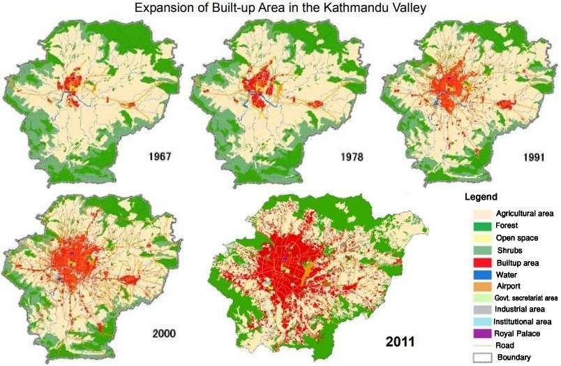
sprawling at the periphery. Figure 5 shows the trend of urban expansion in Kathmandu Valley.
Studies projecting urbanization trend in Kathmandu Valley indicate urbanization will continue
expanding in northeast and southwest direction (Thapa and Murayama, 2012). The population of
the valley is projected to reach 3,794,866 in 2020 and 6,249,958 by 2030 (KVDA, 2015).
Figure 5. Expansion of built-up area in Kathmandu Valley (Source: JICA, 2012).
26 https://www.worldbank.org/en/news/feature/2013/04/01/managing-nepals-urban-transition
21You can also read