Broome Infrastructure Assessment Infrastructure and Services Audit Paper - Broome Future Alliance
←
→
Page content transcription
If your browser does not render page correctly, please read the page content below
LandCorp
     Broome Infrastructure Assessment
Infrastructure and Services Audit Paper

                               October 2016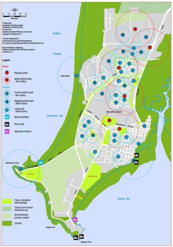
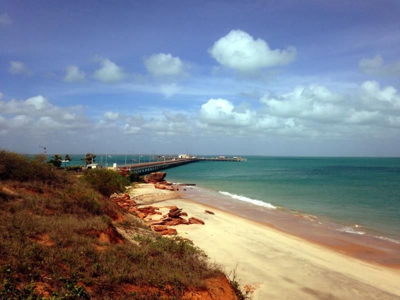
Table of contents
  1.      Introduction..................................................................................................................................... 3

  2.      Purpose of the report ..................................................................................................................... 3

  3.      Methodology ................................................................................................................................... 4
          3.1      Phase 1 – Infrastructure and Services Audit ....................................................................... 4

  4.      Focus Area ..................................................................................................................................... 7

  5.      Physical Infrastructure Audit ........................................................................................................ 10
          5.1      Aviation .............................................................................................................................. 11
          5.2      Marine ................................................................................................................................ 12
          5.3      Power and Communications .............................................................................................. 15
          5.4      Transport ............................................................................................................................ 18
          5.5      Water and Wastewater ...................................................................................................... 19
          5.6      Waste Management ........................................................................................................... 21
          5.7      Land Availability ................................................................................................................. 22

  6.      Social Infrastructure Audit ............................................................................................................ 27
          6.1      Health ................................................................................................................................. 30
          6.2      Education ........................................................................................................................... 32
          6.3      Recreation and community ................................................................................................ 35
          6.4      Emergency services........................................................................................................... 38
          6.5      Key community services and organisations....................................................................... 41

  7.      References ................................................................................................................................... 43

Table index
  Table 1 - List of local reports specific to the Kimberley that have been reviewed in
                consideration to this Audit Paper ......................................................................................... 5

  Table 2 Area of residentially zoned land under the town planning scheme ........................................... 24

  Table 3 Area of commercially zoned land under the town planning scheme ......................................... 25
  Table 4 - Medical facilities in Broome town centre and immediate surrounds ....................................... 31

  Table 5 - Medical facilities in Communities ............................................................................................ 32

  Table 6 - Broome town site education facilities ...................................................................................... 33
  Table 7 - Community education facilities ............................................................................................... 34

  Table 8 - Recreation and Community Facilities ..................................................................................... 38

  Table 9 - Community Services and organisations .................................................................................. 42

                                                                        GHD | Report for Landcorp – Infrastructure Assessment, 61/34560 | i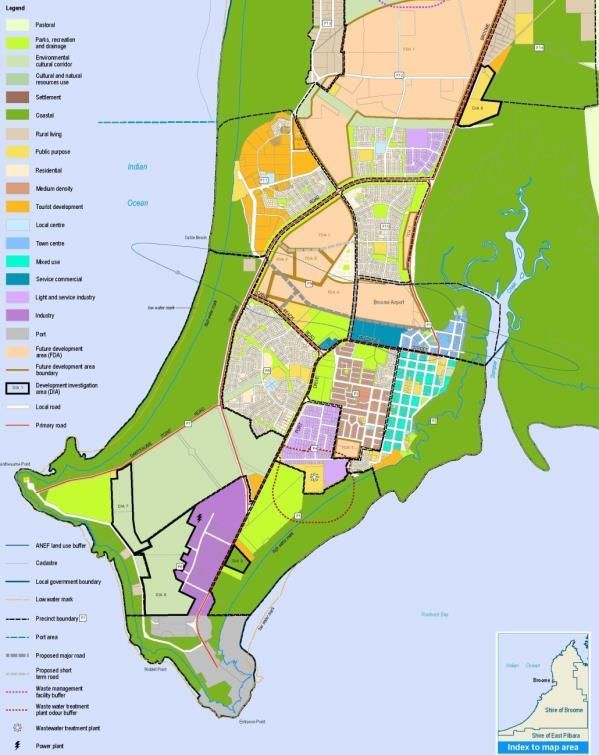
Figure index
  Figure 1 - Summary of assessment process ............................................................................................ 4

  Figure 2 - Shire of Broome study area for this report ............................................................................... 8
  Figure 3 Age distribution for the Shire of Broome (Source: ABS, 2011 Census) .................................... 9

  Figure 4- Broome airport plan (Source: Broome Airport Masterplan) .................................................... 11

  Figure 5 - Port boundaries (Source: KPA Port and Terminal Handbook, Figure 1) ............................... 13
  Figure 6 - Port of Broome Layout (Source: KPA Port and Terminal Handbook, Figure 7) .................... 14

  Figure 7 - Current NBN coverage at nominated locations within Broome (Source:
               www.nbnco.com.au) .......................................................................................................... 16
  Figure 8 - Telstra 3G Coverage (Source: www.telstra.com.au) ............................................................. 17

  Figure 9 - Communication towers (Source: Kimberley Development Commission, ALCES) ................ 18

  Figure 10 - Water pipelines (Source: Kimberley Development Commission, ALCES) .......................... 20
  Figure 11 - Local Planning Strategy - Broome townsite ......................................................................... 23

  Figure 12 Social Infrastructure in the Shire of Broome .......................................................................... 29

  Figure 13 Existing and future district, local and neighbourhood parks in the Broome townsite
              (Source: Shire of Broome local planning strategy) ............................................................ 37

Appendices
  Appendix A – Summary table of Physical Infrastructure

  Appendix B – Study Area

  Appendix C – Social Infrastructure Map

  ii | GHD | Report for Landcorp – Infrastructure Assessment, 61/34560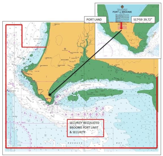
1.   Introduction
     This investigation forms part of the wider Regional Centres Development Plan Phase 2 project
     being undertaken for a number of regional centres within Western Australia. The intention of the
     Regional Centres Development Plan Phase 2 project is to empower regional centres and
     identify opportunities for growth within these regions and to understand current constraints to
     the development of business and industry sectors. To facilitate this growth, the identified towns
     must be ‘ready for business’. The development of growth plans will assist to support these
     centres. LandCorp, working closely with Creating Communities as project lead, engaged GHD
     to review the existing infrastructure within the Shire of Broome and identify potential gaps and
     priorities for future infrastructure to meet the requirements of the growing shire. The audit and
     analysis of Broome’s infrastructure as part of this project will form part of the growth plan.

     Broome faces a number of challenges particularly in relation to employment opportunities. The
     growth plan for Broome will assist in the development of the town. Outcomes of this project will
     help to understand the types of physical and social infrastructure that are required to support
     that growth.

2.   Purpose of the report
     This report provides a high-level audit of the physical and social infrastructure within the Shire of
     Broome. It is intended to quantify the infrastructure to identify whether it provides a comparative
     advantage or impediment to economic growth. This assessment report will assist in formulating
     strategies to enhance physical and social infrastructure in the shire.

                                               GHD | Report for Landcorp – Infrastructure Assessment, 61/34560 | 3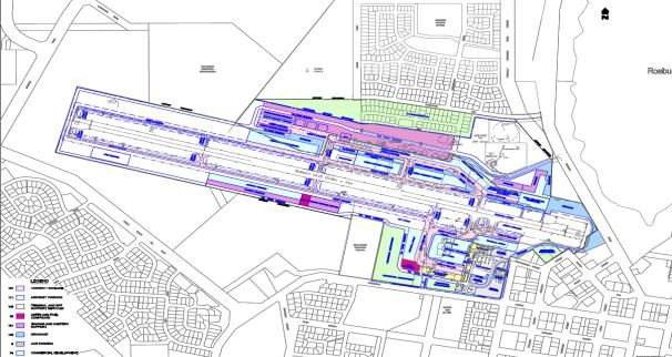
3.          Methodology
            This infrastructure assessment includes an audit of the existing physical and social
            infrastructure and analysis to understand what infrastructure is needed to support the growth
            plan for Broome.

            A summary of the approach taken is provided in Figure 1 below. This shows the ‘whole of
            project’ process, however this audit paper focuses on Phase 1.

            Figure 1 - Summary of assessment process

            3.1         Phase 1 – Infrastructure and Services Audit
            Phase 1 conducted a desktop analysis of physical and social infrastructure available in Broome,
            based on a review of the existing data available. This commenced with a review of the
            significant amount of work already completed relevant to the Broome growth plan. Geographical
            Information Systems (GIS) mapping data and engagement with infrastructure (social and
            traditional) providers. On ground site visits were conducted in Broome to further consolidate the
            findings of the desktop analysis and service agency engagement.

            The physical infrastructure section of this report is intended to be read in conjunction with
            Appendix A – Summary Table of Physical Infrastructure.

            3.1.1       Stakeholders engaged

            Stakeholder consultation on the physical infrastructure has taken place with a number of
            organisations within the Shire of Broome. Whist most organisations have been forthcoming with
            information sharing, there were a number of instances where commercially sensitive information

     4 | GHD | Report for Landcorp – Infrastructure Assessment, 61/34560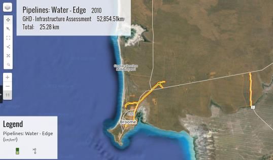
has not been able to be obtained and only publicly available information has informed the audit.
The following organisations were consulted in the audit:
Broome International Airport;
Kimberley Ports Authority;
Horizon Power;
NBN Co.;
Main Roads;
Shire of Broome;
Telstra; and
Water Corporation.
As part of this audit, details of all relevant and current plans and strategies on infrastructure in
Broome was collated and reviewed and Table 1 lists the key reports that were reviewed in this
stage. In addition to the key documents below, a number of other documents and sources were
reviewed as part of this audit. A full list of the sources is provided in the References section.
Table 1 - List of local reports specific to the Kimberley that have been
reviewed in consideration to this Audit Paper
Broome Future Ltd, 2015, Unlocking the Door A study into the feasibility
of Broome as a commercial and logistics hub for the Kimberley Region
Broome International Airport, 2008, Broome Airport Masterplan
Cardno, 2015, Broome Coastal Vulnerability Study
Department of Planning, 2015, Kimberley Regional Planning and
Infrastructure Framework Parts A & B
Government of Western Australia Department of Water, 2012, Broome
Water Reserve Drinking Water Source Protection Plan
GHD | Report for Landcorp – Infrastructure Assessment, 61/34560 | 5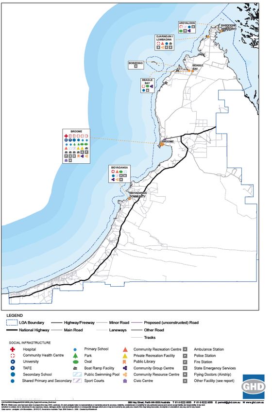
Horizon Power, 2015, Annual Report 2014-15

 Infrastructure Australia, 2015, Northern Australia Audit Infrastructure for
 a Developing North

 Kimberley Development Commission, 2015, 2036 and Beyond: A
 Regional Investment Blueprint for the Kimberley

 Kimberley Port Authority, 2015, Port of Broome Port and Terminal
 Handbook

 LandCorp, 2015, Kimberley Vernacular Handbook

 Main Roads Western Australia, 2013, Kimberley Regional Profile
 2013/14

 Shire of Broome, 2014, Shire of Broome Local Planning Strategy Parts
 1&2

 Sinclair Knight Merz, 2010, Broome North Traffic and Access Report

6 | GHD | Report for Landcorp – Infrastructure Assessment, 61/34560
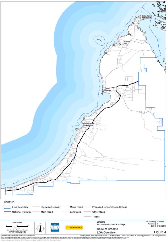
4.   Focus Area
     The Shire of Broome is located in the Kimberley Region of Western Australia. It encompasses
     the regional town of Broome, and a number of Aboriginal communities, including Beagle Bay,
     Bidyadanga, Djarindjin, Lombadina and Ardyaloon.

     The focus area can be seen in Figure 2 below and also provided in Appendix B.

                                            GHD | Report for Landcorp – Infrastructure Assessment, 61/34560 | 7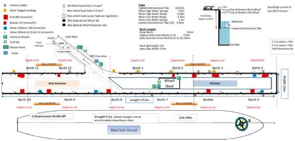
Figure 2 - Shire of Broome study area for this report

8 | GHD | Report for Landcorp – Infrastructure Assessment, 61/34560
The Shire of Broome is well known for its pristine beaches and unique landscapes and is a key
                   tourist destination.

                   According to the 2011 Census, there were 14,997 people living in the Shire of Broome, which
                   was made up of 51% males and 49% females. The median age of the population was 32, with
                   the greatest proportion of the population aged between 25-29, as illustrated in Figure 3.
                   Approximately 29% of the population in the Shire of Broome are Aboriginal and Torres Strait
                   Islander.

                                         Age Distribution for the Shire of Broome
                   1,600
                   1,400
                   1,200
Number of People

                   1,000
                    800
                    600
                    400
                    200
                      0
                            0-4 5-9 10-14 15-19 20-24 25-29 30-34 35-39 40-44 45-49 50-54 55-59 60-64 65-69 70-74 75-79 80-84 85
                           years years years years years years years years years years years years years years years years years years
                                                                                                                                  and
                                                                                                                                 over
                                                                          Age group

                   Figure 3 Age distribution for the Shire of Broome (Source: ABS, 2011 Census)

                   The majority of residents in the shire work full-time (66.5 percent (%)) and 21.4 % work part-
                   time. 4.8 % were unemployed which is only slightly higher than the whole of Western Australia
                   which has 4.7 % unemployment, but is lower than the whole of Australia which has 5.6 %
                   unemployment.
                   Recent population figures for 2015 indicate that the population for the whole of the Shire is
                   17,311 and 13,849 for the Broome townsite (ABS).

                                                                    GHD | Report for Landcorp – Infrastructure Assessment, 61/34560 | 9
5. Physical Infrastructure Audit
The Broome Social and Physical Infrastructure project covers an extensive area – the whole of
the Shire of Broome, however for the purpose of this audit the following locations have been
examined:
The Broome townsite and immediate surrounds;
The Aboriginal communities of Beagle Bay, Bidyadanga, Djarindjin, Lombadina,
Ardyaloon, and Bobieding (where current Community Layout Plans exist).
There are a number of other communities which exist within close proximity to Broome townsite.
It is assumed that they are serviced by the Broome townsite and have therefore not been
considered separately.
For the purpose of this report, the physical infrastructure audit focusses on infrastructure that is
provided at a regional and district level. These types of infrastructure are typically provided by
State and local government agencies. In some instances, private entity providers have also
been included, where the infrastructure provides a regional or district role or function (i.e.
Broome airstrip). In the Aboriginal communities in the region, the audit has included local
physical infrastructure as these communities are unlikely to contain physical infrastructure of a
regional significance.
For the purpose of this audit, the following physical infrastructure has been reviewed in each of
the seven broad categories; Aviation, Marine, Power and Communications, Transport, Water
and Wastewater, Waste Management and Land Availability.
10 | GHD | Report for Landcorp – Infrastructure Assessment, 61/345605.1 Aviation
The masterplan for the Broome International Airport (BIA) was completed in 2008 and is
currently being updated for release later this year. The Broome Future report, having been
completed in 2015 provides an up-to-date analysis of the Broome Airport infrastructure and
some information on the regional airstrips.
Figure 4- Broome airport plan (Source: Broome Airport Masterplan)
5.1.1 Outcomes
Aviation infrastructure within the Shire of Broome is centrally focused around the Broome
airport, providing a critical service to Broome and the surrounding Kimberley region. Outside of
Broome District airstrip, airstrips are located at Beagle Bay, Bidyadanga, Djarindjin and
Ardyaloon. Djarindjin is the second District airstrip within the Shireand is sealed, providing a
staging base for refuelling of helicopters heading from Broome to the Browse Basin.
The Broome Airport is an all-weather jet airport that is 2,458m in length. It has capacity for both
domestic and international aircraft. In recent years, Aircraft movements have been around
34,000 per annum and the airport has the capacity for 160,000 airport movements per annum 1.
“BIA routinely receives aircraft with a Maximum Take-off Weight (MTOW) of around 80,000kg,
which includes Boeing 737-800 and Airbus A320 commercial passenger aircraft. The runway
can accommodate larger aircraft, including the world’s eighth largest cargo plan, the Ilyushin IL-
76 which has a maximum MTOW of 210,000kgs.”2
A constraint of BIA is that the ground infrastructure is unable to accommodate larger container
loaded aircraft including wide-body Boeing 777 and the Airbus A330.
Recent investments to infrastructure at BIA include;
$14 million runway asphalt overlay and grooving program in 2013
$3 million in runway lighting in 2016
$3 million for upgrades to the main passenger handling facility
1 Broome International Airport, 2008
2 Broome Future Limited, 2015
GHD | Report for Landcorp – Infrastructure Assessment, 61/34560 | 11 $23 million for a joint facility between Air Services Australia (ASA) and the Aircraft
Rescue and Fire Fighting (ARFF) in 2012
$14 million in a heavy helicopter facility in 2008-09
BIA have discussed the potential relocation of the airport to a site 13 km out of town that
presents a number of advantages for the region, however the Broome Future report outlines
that it will not take place in the foreseeable future.
5.1.2 Conclusion
The aviation infrastructure capacity is well serviced in Broome and Djarindjin, however limited in
remote regions within the shire.
Advantage
Recent upgrades to the Broome airport infrastructure in excess of $57 million
Potential airport relocation presents a number economic benefits for the Broome region
Aircraft movements are less than a quarter of the total capacity of the airport
Adequacy of runway allows for direct east coast flights and potential international services
Constraint
No ground infrastructure to allow for landing of container-loaded aircraft
Unable to handle domestic and international flights simultaneously
Local airstrips are unsealed
Site location constraints limit options to expand existing RPT apron and runway
Helicopter noise presents operational restrictions
Uncertainty on the timeframe of the relocation
5.2 Marine
The focus of the audit of the marine infrastructure has been based around desktop review of
publicly available documents. The Port and Terminal Handbook for the Kimberley Ports
Authority (KPA) is updated annually and KPA is currently in the process of developing their Port
Master Plan. The Broome Future report dates to April 2015 and provides an analysis and
summary of the port infrastructure.
Further information has been added on the capacity and constraints in the recommendations
section on the marine infrastructure and available in the marine summary table in Appendix A.
5.2.1 Outcomes
The marine infrastructure within the Shire of Broome is limited with the exception to the Port of
Broome. The Port of Broome is the main intermodal cargo and passenger gateway to the
Kimberley.3 An extension to the wharf was completed in 2005 and now provides a total of 331
metres of wharf space on the outer face plus 279 meters of inner berthing capacity. There is a
naturally occurring channel that provides entry for large vessels into the port which plays a key
role in the Kimberley for movement of goods in and out of the community.
3 Broome Future Limited, 2015
12 | GHD | Report for Landcorp – Infrastructure Assessment, 61/34560“…there is increased demand for hardstand areas for temporary storage and recently the wharf
underwent refurbishment to improve access for small commercial (pearling, fishing and tourist
charters) and government use (navy, customs and fisheries).” 4.
Figure 5 - Port boundaries (Source: KPA Port and Terminal Handbook, Figure
1)
The Port currently has the capacity and infrastructure to accommodate:
Containers and general cargo;
Livestock export;
Petroleum and fresh water for offshore oil and gas industry;
Drilling equipment and bulk product in association with offshore oil and gas industry; and
Cruise ships (size restrictions).
Further investment is currently underway with a $24.15M wharf strengthening (Wharf Extension
of Life (WEOL)) program to allow the port to operate at full capacity.
4 Broome Future Limited, 2015
GHD | Report for Landcorp – Infrastructure Assessment, 61/34560 | 13Figure 6 - Port of Broome Layout (Source: KPA Port and Terminal Handbook,
Figure 7)
5.2.2 Conclusion
The marine infrastructure capacity is well serviced in Broome, however is non-existent in remote
regions within the shire with the exception of one boat ramp in Ardyooloon and the absence of a
marina or sheltered harbour for smaller commercial vessels/fleets is a deficiency.
Advantage
Recent upgrades on the wharf to allow the port to operate at full capacity for the long term
Provision of the master plan provides opportunity to outline development strategies for
the port, in short, medium and long term
The port’s land is well segregated from Broome residential and recreational hubs
Adequacy of berthing capacity and shipping channel allows for larger vessels to utilise the
port twenty-four hours a day, seven days a week
Constraint
The wharf is rated for a maximum arrival displacement of 40,000 tonnes
Shipping limitations at the wharf allow for a maximum draft of 9.1 meters (tidal
dependent)
Long access jetty and narrow wharf width create operational restrictions
No marina or sheltered harbour for smaller commercial vessels/fleets
Non optimal mix of recreational and commercial port users
Port of Broome does not have a waste disposal facility
Port of Broome does not have a dry dock facility
Lack of marine infrastructure in the Kimberley
The Port master planning process is still underway and may impact on Port and Marine
Park boundaries which would need to be considered in any future developments.
14 | GHD | Report for Landcorp – Infrastructure Assessment, 61/345605.3 Power and Communications
Power
The following government and commercial sources were consulted for further information:
Department of Finance – Public Utilities Office;
Department of Planning;
Department of Aboriginal Affairs – Map of Kimberley region showing locations of
aboriginal communities;
Energy Departments; and
Horizon Power
5.3.1 Outcomes
Electrical generation/distribution
The electrical distribution networks within the Shire of Broome are owned and operated by
Horizon Power (HP), with electrical generation provided by Energy Developments (EDL) as an
Independent Power Producer (IPP). Together HP and EDL provide isolated diesel generated
power supply to each of the four main communities (Bidyadanga, Beagle Bay, Djarindjin and
Ardyaloon) due to the vast distances in the region. The power supply in Broome is generated
from diesel and natural gas with the plant located near the Port of Broome.
Gas supplies
Currently in the Shire of Broome (including Broome) there is no reticulated gas supply and all
gas is transported and stored in tanks.
5.3.2 Conclusion
The power infrastructure within the Shire is regionally isolated through the vast distances of
separation.
Advantage
Horizon Power provides and extensive supply of assets to power the regional
communities within the Shire
Constraint
Regional communities are isolated by power supplies;
Broome’s diesel and natural gas plant may need to move as the town grows;
No reticulated gas supply within the Shire. All gas is transported in and stored in tanks
and bottles; and
The current diesel and gas power station in Broome also has no reticulated gas supply;
bottled gas stored near the existing landfill facility is trucked to the station.
Communications
The area of the audit has been based around desktop review of publicly available documents
GHD | Report for Landcorp – Infrastructure Assessment, 61/34560 | 155.3.3 Outcomes
Internet
ADSL internet is provided at limited capacity throughout the townsite of Broome and is
dependent of the number of ports allocated and proximity to nearest ADSL exchange point.
ADSL is not available at any of the regional communities in the Shire. Regional communities are
reliant on wireless devices for internet supply.
National Broadband Network (NBN) is only available in Broome North however there is current
work underway to replace the ADSL network in 7,000 locations in Bilingurr, Broome, Cable
Beach, Djugun and Minyirr. These works have begun in July 2016, however will not be active
for 18 months after construction is complete and the ADSL copper lines are switched off.
Connections are anticipated to be active in January 2019.
Figure 7 - Current NBN coverage at nominated locations within Broome
(Source: www.nbnco.com.au)
Telecommunications
The Broome town centre has good mobile (3G and 4G) coverage and land line capability.
Regional communities are limited to 3G mobile coverage and land line connections. “Apart from
Telstra, Vodafone and Optus have limited network coverage in the region. Mobile phone
reception is generally poor or non-existent along the region’s major roads and at road houses.” 5
The main issue with mobile coverage in the Shire of Broome is the road network and travelling
between communities with little or no coverage for long stretches of road.
Further GIS infrastructure mapping of Telstra’s telecommunications network can be obtained (at
a cost) to provide a more comprehensive study.
5 Kimberley Regional Planning and Infrastructure Framework Part B, 2015
16 | GHD | Report for Landcorp – Infrastructure Assessment, 61/34560Figure 8 - Telstra 3G Coverage (Source: www.telstra.com.au)
5.3.4 Conclusion
Communications infrastructure is regionally isolated throughout the shire and non-existent along
long stretches of roads.
Advantage
NBN cables were installed in Broome North in 2012;
Current works are in progress to install cables to the rest of Broome to replace the current
ADSL enabled exchange;
Royalties for Regions funding has allowed expansion of terrestrial mobile, voice and high
speed wireless data broadband to improve highway and town-to-town coverage; and
The main population centres have good mobile telephone coverage.
Constraint
ADSL broadband availability is limited to Broome and to within only a few kilometres of
ADSL enabled exchanges;
NBN not available in most parts of Broome until approximately January 2019
No future plans for NBN installation in remote communities
Communities currently have limited network coverage;
Long stretches of the Shire’s major roads have very limited coverage, generally poor or
non-existent; and
Apart from Telstra, Vodafone and Optus have limited network coverage in the region.
GHD | Report for Landcorp – Infrastructure Assessment, 61/34560 | 17Figure 9 - Communication towers (Source: Kimberley Development
Commission, ALCES)
5.4 Transport
This section focuses on road transport within the Broome town area and throughout the Shire of
Broome. It is based on a desktop review of publically available material and the draft Broome
Traffic Study (October 2016).
There are no rail or light rail systems within the study area.
Region
An extensive network of over 7,700 kilometres of roads services the region’s towns,
communities and resource development projects. Heavy rains associated with the wet season
can isolate sections of the road network and provide a challenge in providing consistent road
freight delivery. All major arterial routes and their laterals, including the Great Northern Highway,
are subject to flooding and destruction during the wet season.
Low traffic volumes and long distances between communities present an ongoing challenge in
maintaining a high standard road network.
Upgrades to the Broome – Cape Leveque Road are scheduled for 2017.
Broome townsite
The townsite is located on a peninsula, with Broome Highway being the only major road access.
The main arterial through the town is Gubinge Road, which provides access to the Cable Beach
tourist precinct, the port and indirectly to the CBD (Chinatown). Gubinge Road is capable of
expansion to a four-lane dual carriageway, with adequate capacity for any foreseeable demand.
It carries a high percentage of heavy vehicles, which is undesirable in locations with high
pedestrian and cyclist usage.
Other important roads are Frederick Street and Port Drive, both of which are capable of upgrade
to increase capacity when warranted, and Old Broome Road which is one of the few north-south
connectors in the town.
Streets around Chinatown exhibit local congestion during busy periods. Local roadworks and
intersection improvements may help reduce this congestion.
18 | GHD | Report for Landcorp – Infrastructure Assessment, 61/345605.4.1 Conclusion
A large portion the shire’s roads are unsealed and/or tracks which provide limited capacity
throughout the yearly cycle of changing climate.
Advantage
Broome townsite is reasonably well serviced with good standard arterial roads, many of
which are able to be upgraded when required.
All existing roads and intersections appear to operate within acceptable levels of service
in 2016.
Constraint
Long distances and low traffic volumes make it difficult to achieve a positive benefit –
cost ratio for upgrading most of the roads throughout the region.
5.5 Water and Wastewater
The focus of the audit has been based around desktop review of publicly available documents
including the current DER Licenses for the Water Corporation’s Broome (south) and Broome
North wastewater treatment plants (WWTPs).
Consultation with the Water Corporation’s Asset Investment Planning group has been
undertaken in order to obtain specific information on capacity of the water supply and
wastewater systems.
5.5.1 Outcomes
The Broome Water Supply, operated by the Water Corporation, sources water from the
superficial Broome Sandstone Aquifer in the Townsite groundwater subarea of the Broome
Groundwater Management Plan 1994.. The Broome Townsite groundwater subarea is fully
allocated and the Cable Beach Subarea is nearing allocation limits. This reduces opportunities
for proponents to access water from these subareas as an alternative to using scheme water.
The town water supply borefield, located approximately 12km north-east of Broome, currently
has 18 production bores. The borefield is not electrified, rather the submersible borehole
pumps are powered by diesel generator sets.
As the demand for water increases, the borefield is to be extended to the north, and ultimately
could extend as far as Willie Creek.
Water from the borefield is pumped to a clearwater tank at the southern extremity of the
borefield where it is disinfected. From the Clearwater tank water is pumped to two ground
storages, one at Blackman Street and the other near Bilingurr. Water is transferred from these
tanks to the distribution and reticulation system.
The Broome Town Water Supply currently supplies 5,940 water service connections, with
5.2GL/a abstracted from the borefield.
GHD | Report for Landcorp – Infrastructure Assessment, 61/34560 | 19The maj ority of the Broome townsite ar ea is s ewered. The Water Cor por ati on’s Br oome wastewater sc heme c ompris es a c onventi onal gravi ty s ewer reticul ation networ k, a number of wastewater pump stati ons and ass ociated rising mains, and two was tewater tr eatment pl ants ( WWTPs) – the original Br oome (s outh) WWT P and the newer Broome North WWT P that was commissi oned i n 2011.
Figure 10 - Water pipelines (Source: Kimberley Development Commission,
ALCES)
The Broome sewerage scheme, operated by the Water Corporation, collects, treats and
disposes of wastewater generated within the Broome townsite area, currently an average
annual daily flow [AADF] of approximately 3.5 ML/d. The scheme comprises a gravity sewer
reticulation network, a series of wastewater pump stations and pressure mains, and two
treatment plants and associated treated wastewater disposal/reuse schemes. The two WWTPs,
the original Broome WWTP located near the southern end of the townsite, and the Broome
North WWTP located approximately 6km north east of the airport, are both pond-type treatment
plants. In the Kimberley Region the Water Corporation aim to achieve a minimum total
hydraulic retention time of 30 days in treatment/storage ponds to manage helminth risk. The
Broome North WWTP includes a significant treated wastewater storage pond to ensure this is
achieved, and provide seasonal and wet weather balancing storage for the land disposal
scheme.
Treated wastewater (TWW) from the Broome WWTP is, after filtration and chlorination, used for
irrigation of the adjacent golf course (Broome Golf Club) and several sporting fields and
recreation areas, with the minor flows surplus to irrigation demands discharged to
storage/evaporation ponds on the WWTP site. TWW from the Broome North WWTP is
disposed of via centre-pivot irrigation of Rhodes grass pastures established on the WWTP site.
At present infrastructure does not exist to allow TWW from the Broome North WWTP to be
returned to the townsite area for reuse.
Recent upgrades completed by Water Corporation in the Shire of Broome include:
$2.7 million project to install 1.5 kilometres of water main to improve the water supply to
the areas of Cable Beach and Roebuck Estate, completed in 2015;
Expansion of the Broome borefield by drilling three new production bores. These bores,
which have a capacity of 1.5 million litres per day, were completed in 2015;
Upgrade of the water main that runs along Port Drive, by installing a 4.8 kilometres
section of pipe from the Blackman Street tank site to the Broome Port, completed in 2014;
Construction of a 4.3 kilometres water main from the intersection of Broome Road and
Wattle Drive to the intersection of Coghlan Street and Napier Terrace, completed in 2011;
20 | GHD | Report for Landcorp – Infrastructure Assessment, 61/34560 $9.1 million project to construct a 15 million litre ground level storage tank at Blackman
Street, completed in 2013; and
$37.2 million project to construct the Broome North WWTP and associated conveyance
system modifications (including new 9.9 kilometre pressure main) and on-site treated
wastewater disposal infrastructure, completed in 2011.
“The Water Corporation has defined a staged approach to infrastructure development in
Broome based on current growth forecasts.” 6 Whilst ageing water and wastewater infrastructure
continues to present asset management challenges in the region, the Water Corporation’s long
term planning and asset management processes cater for asset renewal.
5.5.2 Conclusion
The water supply borefield is required to be extended to the north as the population grows.
Similarly, upgrades of pipelines that transfer borefield production into town storages will also be
required
The wastewater treatment capacities are comfortably meeting demands with recent upgrades.
Advantage
The Broome North WWTP is a new installation and has surplus capacity (in terms of both
its treatment capacity and its treated wastewater (TWW) disposal capacity)
Groundwater abstracted by the town water supply borefield is of high quality, requiring
disinfection only, and additional source capacity can be provided by extending the
existing borefield
The Water Corporation have completed a number of significant projects in recent years to
upgrade the Broome townsite’s water supply and wastewater infrastructure.
Saline water intrusion impact on the town water supply is expected to be minimal
(monitoring bores have been installed to provide early warning of any such impacts)
Constraint
The borefield collector main in the southern part of the borefield is ageing and
approaching capacity.
The water supply distribution system downstream, south of the airport is ageing and in
sections, in poor condition.
There is some concern that Broome WWTP (south) is having a detrimental impact on
Roebuck Bay. This potential impact is being investigated by the Water Corporation, and
the potential need to undertake pond relining works to minimise seepage losses from the
treatment and storage/evaporation ponds is being considered.
Infrastructure does not exist to allow TWW from the Broome North WWTP to be returned
to the townsite area for reuse.
5.6 Waste Management
Landfill sites of varying capacity are located throughout the Shire of Broome at each of the
communities and Broome’s Waste Management Facility is located 6km north of Broome on
Buckley’s Road with access from Fairway Drive.
6 Kimberley Regional Planning and Infrastructure Framework Part B, 2015
GHD | Report for Landcorp – Infrastructure Assessment, 61/34560 | 21“The facility is an ageing site and is nearing its capacity. Based on current input volumes the
remaining lifespan of the facility is anticipated to be four years. “7
A new landfill site will need to be developed within the Broome region in order to accommodate
the current capacity limitations by 2020.
The following information was provided directly from the Waste Management Coordinator at the
Shire of Broome:
“The (Broome) landfill is approaching the end of its operational life as a landfill. In January 2020
the landfill will have reached its baseline capacity. To ensure continuity of services the Shire is
progressing the Regional Resource Recovery Park (RRRP) as its replacement.”
5.6.1 Conclusion
The waste at the current landfill site will reach capacity in 2020 and a new landfill site is being
investigated.
Advantage
Current site selection process in place to determine the next location for the RRRP
Constraint
The current landfill site will have reached its baseline capacity by January 2020
5.7 Land Availability
The Shire of Broome (the Shire) is located in the Kimberley Region of Western Australia.
Planning and land use requirements in the Shire are informed by the Shire of Broome Local
Planning Scheme No. 6 (LPS6).
The focus of this audit is on availability of residential, commercial and industrial land. These
land uses are typically concentrated within the main Broome townsite; however there are
pockets of rural residential and low impact tourism outside the main townsite, around the Shire.
In addition to the Broome townsite, there are 83 settlements located throughout the Shire, as
specified in the local planning strategy. 10 of the settlements require Community Layout Plans
however only seven have endorsed Community Layout Plans which provide a framework for
land use and development.
The following audit of land availability has been based on a desktop review of key planning
documentation including:
Shire of Broome LPS6;
Shire of Broome, 2014, Local Planning Strategy;
Department of Planning, 2008, Broome Regional Hotspots;
Shire of Broome, 2007, Local Commercial Centre Strategy; and
Shire of Broome, 2009, Local Housing Strategy.
Generally, future planning within the Broome townsite will be guided by the Local Planning
Strategy, as set out below.
7 Kimberley Vernacular Handbook, 2015
22 | GHD | Report for Landcorp – Infrastructure Assessment, 61/34560Figure 11 - Local Planning Strategy - Broome townsite
5.7.1 Residential
Zoned land
The current Shire of Broome Town Planning Scheme No. 6 contains 366.57 hectares of
residentially zoned land and 1,086.73 hectares of development zone. The residentially zoned
land is further divided into 12 differently coded areas as shown in below.
GHD | Report for Landcorp – Infrastructure Assessment, 61/34560 | 23Table 2 Area of residentially zoned land under the town planning scheme
Zone Area (ha)
Residential R5 0.3
Residential R10 33.48
Residential R10/20 3.49
Residential R12.5 73.76
Residential R15 17.3
Residential R17.5 16.06
Residential R20 120.07
Residential R25 5.02
Residential R30 66.07
Residential R30/40 5.84
Residential R40 16.55
Residential R50 8.63
TOTAL 366.57
The Shire of Broome Local Housing Strategy identifies areas within the Broome townsite for
future residential. Under LPS6, most of these areas are identified on the scheme as
development zone. Development within the development zone is to be in accordance with an
adopted structure plan. Most of the future development within the Broome townsite is
envisaged for the northern part of the townsite and on the existing Broome airport site.
Housing
According to the Shire of Broome Local Planning Strategy (2014), there are currently
approximately 5,167 private occupied and unoccupied dwellings in the Shire as per the 2011
Census.
There is 1,086.73 hectares of ‘development’ zone within the Shire. Assuming a density of R20
for this land, the development zone could accommodate approximately 24,171 dwellings. It is
likely that this dwelling potential would be reduce as this does not take into consideration that
the 1,086.73 hectares could also include road infrastructure, public open spaces, commercial
areas and other public purpose uses.
5.7.2 Commercial
Zoned land
Commercial land uses are typically found on land zoned for commercial purposes. The Shire of
Broome LPS6 does not contain a purely commercial zone; instead it classifies the following
zones as commercial zones:
Town centre
Local centre
Mixed use
Service commercial
In addition to the above, there are two tourism zones.
Tourist
24 | GHD | Report for Landcorp – Infrastructure Assessment, 61/34560 Low impact tourist
Other areas within the scheme may facilitate commercial land uses including the development
zone, subject to the requirements of an adopted structure plan and the settlement zone, subject
to the requirements of an endorsed Community Layout Plans.
The area of commercially zoned as defined in the local planning scheme is outlined in Table 3
below.
Table 3 Area of commercially zoned land under the town planning scheme
Zone Area (ha)
Town Centre 30.48
Local Centre 10.13
Mixed use 19.43
Service commercial 9.56
Tourist 123.67
Low impact Tourist 651.32
Commercial floorspace
The Shire undertook a review of its Local Commercial Strategy (LCS) in 2006 and 2007. The
LCS is current until 2021 and therefore relevant to this audit. Broome has 70,000m 2 of
commercial floorspace. Of that total, 40,000m 2 relates to retail. The majority of the floorspace is
located within two areas of the Broome townsite – Chinatown and the Broome Boulevard
Shopping Centre (LCS, 2007).
Since preparing the LCS, the Shire has prepared a study titled, Cable Beach Development
Strategy (2016), which includes a retail needs assessment. The retail needs assessment looks
at the current provision of commercial floorspace. The Cable Beach Development Strategy
states that there is closer to 49, 200m2 of retail floorspace.
5.7.3 Industrial
Zoned land
675 hectares of land is zoned for industrial activity, with 480 hectares not yet developed. The
land available for industrial activity comprises 492 hectares of General Industry zoned land, 69
hectares of Light and Service Industry zoned land and 114 hectares of land available for the
Port (Shire of Broome Local Planning Strategy, 2014).
The proposed LNG processing precinct was to provide a further 200 hectares of general
industry development near James Price Point, but this project has been suspended.
There are areas of industrial land identified in the Community Layout Plans of Ardyaloon (6
lots), Beagle Bay (3 lots), Bidyadanga (4 lots), Djarindjin/Lombadina (11 lots).
5.7.4 Land tenure
Land tenure within Aboriginal settlements is identified in the Shire’s local planning strategy as a
major issue. The tenure status of much of the land as Crown reserve or held by the Aboriginal
Lands Trust limits the ability for the community to develop the land. However as identified in the
GHD | Report for Landcorp – Infrastructure Assessment, 61/34560 | 25local planning strategy this also protects community members from being displaced by other
developers wanting to develop the land.
26 | GHD | Report for Landcorp – Infrastructure Assessment, 61/345606. Social Infrastructure Audit
The State Planning Strategy 2050 (WAPC, 2014) states that;
8‘Social infrastructure is the interdependent mix of facilities, places, spaces, programs,
projects, services and networks that maintain and improve the standard of living and
quality of life in a community’
The Broome Social and Physical Infrastructure project covers an extensive area – the whole of
the Shire of Broome, however for the purpose of this audit the following locations have been
examined:
The Broome townsite and immediate surrounds;
The Aboriginal communities of Beagle Bay, Bidyadanga, Djarindjin, Lombadina,
Ardyaloon, and Bobieding (where current Community Layout Plans exist).
There are a number of other communities which exist within close proximity to Broome townsite.
It is assumed that they are serviced by the Broome townsite and have therefore not been
considered separately.
For the purpose of this report, the social infrastructure audit focusses on infrastructure that is
provided at a regional and district level. These types of infrastructure are typically provided by
State and local government agencies. In some instances private entity providers have also been
included, where the infrastructure provides a regional or district role or function (i.e. golf course).
In towns and communities, the audit has included local social infrastructure as these
communities are unlikely to contain social infrastructure of a regional significance.
The social infrastructure being audited as part of this investigation includes health, education,
recreation and community, emergency services and key community services and organisations.
For the purpose of this audit, the following infrastructure has been reviewed in each of the five
broad categories.
1. Health infrastructure
o Hospitals (both private and public)
o Community health centres
2. Education infrastructure
o Tertiary education (university/TAFE)
o Secondary schools (private and public)
o Primary schools (private and public)
3. Recreation and community infrastructure
o Parks (regional and district)
o Community recreation centres
o Public swimming pools
o Sport courts (tennis, basketball etc)
o Private recreation facilities (golf course)
4. Emergency services infrastructure
8 State Planning Strategy, 2014
GHD | Report for Landcorp – Infrastructure Assessment, 61/34560 | 27o Police station
o Fire station
o Ambulance stations
o State Emergency Services
5. Key Community services and organisations
o Civic centres – town halls and community centres
o Community group centres
o Library
This audit has been undertaken using publically available information on state and local
government agency and private websites and in publically available documentation. A summary
of the existing social infrastructure is shown in Figure 12 and in Appendix C.
28 | GHD | Report for Landcorp – Infrastructure Assessment, 61/34560Figure 12 Social Infrastructure in the Shire of Broome
GHD | Report for Landcorp – Infrastructure Assessment, 61/34560 | 29Broome is classified as a regional city in the settlement hierarchy under the Draft Kimberley
Regional Planning and Infrastructure Framework (KRPIF) (2014). A regional city is the highest
order settlement in the region. Some key characteristics of a regional city include high levels of
population and economic growth, serviced by regional significant infrastructure, a range of
commercial and community activities and a high level of housing and land demand (Draft
KRPIF, 2014).
The above towns and communities have existing Community Layout Plans which provide
background information to the locality and guide future development. It should be noted that
Djarindjin\ Lombadina is a township with two separate Aboriginal Corporations. They have their
own individual Community Layout Plans however many of the infrastructure mentioned in the
individual plans, service both communities.
A number of documents and sources were reviewed to understand the social infrastructure
available in the Shire of Broome. In addition, the following stakeholders were contacted via
phone:
Kimberley Education Regional Office
Department of Health – WA Country Health Services
Broome Police Station
Broome Royal Flying Doctors Services Base
Kimberley Aboriginal Medical Services Council
Sacred Heart School Beagle Bay
6.1 Health
6.1.1 Stakeholder consultation
In order to understand the capacity of the health infrastructure, the Department of Health and
the Kimberley Aboriginal Medical Service Council were contacted via telephone. The following
queries were asked:
1. Are there any issues with your current service delivery in terms of capacity?
2. Are there any plans for expansion?
Department of Health – WA Country Health Services
Consultation was undertaken with the WA Country Health Services. The Broome Hospital has
undergone a number of upgrades in the last seven or eight years in particular to the emergency,
paediatrics and mental health departments. The hospital currently has sufficient capacity in
terms of beds and within the emergency department. At this point in time, there are no
upgrades planned.
Kimberley Aboriginal Medical Services Council (KAMSC)
KAMSC is a regional Aboriginal Community Controlled Health Service. There are clinics located
in Bidyadanga and Beagle Bay as well as a facility in Broome.
The facility at Bidyadanga does not have sufficient capacity and they would be looking at
securing additional land. The facility at Beagle Bay was recently added to and it currently has
sufficient capacity. Each of the clinics have nurses present and are visited by doctors and allied
health professionals multiple times a week.
30 | GHD | Report for Landcorp – Infrastructure Assessment, 61/345606.1.2 Broome town centre and immediate surrounds
Major health infrastructure in the Shire is located in the Broome townsite. Details of these
facilities are listed in the below table.
Table 4 - Medical facilities in Broome town centre and immediate surrounds
Facility Name Facility Details, services and facilities
Less than 50 beds (MyHospitals, 2016)
Broome Health Campus Allied health, day hospital, emergency, high dependency unit, maternity,
(hospital) medical imaging, mental health, paediatrics, palliative care, specialist
outpatient clinic and a theatre (Department of Health, 2013)
Aged Care Assessment Team, Assistance with Care and Housing for the
Aged (ACHA), Commonwealth Carelink and Respite Care Centre, FINE
(Friend in Need Emergency), HACC Project Officer, Home and Community
Kimberley Aged and
Care, Home Care Packages HCP2 and HCP4), Older Patient Initiative,
Community Services
Regional Home and Community Care (HACC) and Access Program, Remote
Continence Service, Remote HACC, Respite Care, Stroke Service
(Department of Health, 2013)
Alcohol and Drugs, Anxiety, Cultural Orientation, Depression, Eating
Kimberley Mental Disorders, Health Promotion, Mental Health, Positive Parenting Program,
Health and Drug Psychiatry, Psychiatry- Aboriginal, Psychiatry- Adolescent, Psychiatry Adult,
Service Psychiatry-Elderly, Psychiatry- Emergency, Psychiatry-Paediatric, Psychiatry-
Transcultural, Self-Harm Intervention, Suicide Prevention/Intervention
(Department of Health, 2008)
Broome Community
Community health services. Specific services not listed in available data.
Health Service
Kimberley Population
Community health services. Specific services not listed in available data.
Health Unit
Kimberley Aboriginal
Community health services. Specific services not listed in available data.
Health Promotion Unit
In addition to the range of Government run facilities above, there are multiple privately run
health centres which provide general practitioner services and other health support to the local
community.
A government dental clinic is also located in the Broome townsite.
Photo: Broome Hospital located within the Broome townsite
6.1.3 Communities
Health centres are provided at Bidyadanga, Beagle Bay, Lombadina and Ardyaloon. The
details of these are provided in the table below.
GHD | Report for Landcorp – Infrastructure Assessment, 61/34560 | 31Table 5 - Medical facilities in Communities
Community Facility Name Facility Details
Ardyaloon Community Includes two remote nurses, and Aboriginal health
Ardyaloon Remote Area Health worker and facility support staff (Department of
Service Health, 2013).
7 Aboriginal health workers (two trainees), a nurse
Beagle Bay Beagle Bay clinic and facility support staff (Beagle Bay Layout Plan 1,
2013)
Includes fulltime clinic manager, five Aboriginal
Bidyadanga Community health workers, four registered nurses and facility
Bidyadanga
Clinic support staff (Kimberley Aboriginal Medical Services
Council, 2011)
The community of Bobieding access health services
Bobieding Nil. at Beagle Bay or Broome (Bobeiding Layout Plan 1,
2004).
Lombadina/Djarindjin This facility is jointly used by the communities of
Djarindjin
Health Clinic Lombadina and Djarindjin
Includes two remote area nurses, an Aboriginal
Lombadina Remote Area
Lombadina health worker and facility support staff (Department
Health Service
of Health, 2013).
6.1.4 Capacity Issues
The information obtained through the desktop review of information does not provide insight into
any capacity issues currently being experienced by health services. This will be further
investigated through ongoing stakeholder consultation.
6.2 Education
Education infrastructure includes primary, secondary and tertiary education facilities.
6.2.1 Stakeholder consultation
In order to understand the capacity of the education facilities, the Department of Education and
Catholic Education Office, were contacted via telephone. The following queries were asked:
1. Are there any issues with your current service delivery in terms of capacity?
2. Are there any plans for expansion?
Department of Education – Kimberley Education Regional Office
The Department of Education provided informal advice via telephone conversation. They
advised that there is currently capacity within the schools in Broome. There had been a
reduction in the population in the last few years as a result of a large infrastructure project no
longer going ahead. The new primary school at Broome North has capacity as do the other
schools in Broome, however some of the schools including Cable Beach Primary School,
Broome Primary School and Broome Senior High School are close to capacity.
There is forward planning to look at another primary and secondary school in Broome.
Engawa Architects - Catholic Education
Engawa architects were contacted as the key stakeholder who is familiar with the Catholic
schools within the Shire. It is understood that expansion will only occur if there is an increase in
student numbers. There are plans to improve and increase facilities at St Mary’s College,
however increased capacity works will only occur if the numbers support this. At this point, only
improvements are envisaged for Beagle Bay and Lombadina.
32 | GHD | Report for Landcorp – Infrastructure Assessment, 61/345606.2.2 Broome town centre and immediate surrounds
Primary
The Broome town centre is serviced by four independent primary schools and one private
primary Catholic School - St Mary’s College, a private, co-education school. The four
independent public schools are Broome Primary School, Broome North Primary School, Cable
Beach Primary School and Roebuck Primary School.
Secondary
Within the Broome town centre there are two secondary school options provided by the Broome
Senior High School, an independent high school and St Mary’s College.
Tertiary
Tertiary education in the region is provided by Notre Dame University and the Broome North
Regional TAFE.
Details of the latest enrolment numbers and intake years are provided in the table below for
each of the abovementioned facilities.
Table 6 - Broome town site education facilities
Name Gov/Non-Gov Facility Type Details
Notre Dame
Private Tertiary Enrolment details not available.
University
4,631 people enrolled across the
Broome North
Government Tertiary Kimberley (Kimberley Training Institute
Regional TAFE
Annual Report 2015)
Broome Senior High Independent public
Secondary 850+ students (Dept. of Education)
School school
Private Kindergarten to year 12,
Primary and
St Mary’s College coeducational enrolment of 648 students (St Mary’s
Secondary
Catholic School College, 2014)
Kindergarten to year 7
Broome Primary Independent public
Primary Approximately 400 students (Dept. of
school school
Education)
Independent public Kindergarten to year 6
Broome North PS Primary
school 225 students (Dept. of Education)
Kindergarten to year 6
Independent public
Cable Beach PS Primary 395 students (Dept. of Education,
school
2015)
Kindergarten to year 6
Independent public
Roebuck PS Primary Approximately 535 students (Roebuck
school
Primary School 2015 Annual Report)
GHD | Report for Landcorp – Infrastructure Assessment, 61/34560 | 33You can also read