MCDONALDS SWAMP ENVIRONMENTAL WATERING PLAN - July 2010
←
→
Page content transcription
If your browser does not render page correctly, please read the page content below

MCDONALDS SWAMP
ENVIRONMENTAL WATERING PLAN

PREPARED FOR THE
NORTHERN VICTORIA IRRIGATION RENEWAL PROJECT

July 2010
McDonalds Swamp                                                           Environmental Watering Plan

DOCUMENT HISTORY AND STATUS
Version         Date Issued              Prepared By                      Reviewed By          Date Approved
Version 1       29 January 2010          Rebecca Lillie, Michelle Bills   NVIRP TAC            8 February 2010
                                         and Emer Campbell
Version 2       9 February 2010          Rebecca Lillie, Michelle Bills   ERP                  10 March 2010
                                         and Emer Campbell
Version 3       7 May 2010               Rebecca Lillie, Michelle Bills   ERP                  13 May 2010
                                         and Emer Campbell
Version 4       21 May 2010              Rebecca Lillie, Michelle Bills   NVIRP, ERP           28 May 2010
                                         and Emer Campbell
Version 5       28 May 2010              Rebecca Lillie, Michelle Bills   NVIRP, ERP           28 May 2010
                                         and Emer Campbell
Version 6       4 June 2010              Rebecca Lillie, Michelle Bills   NVIRP                4 June 2010
                                         and Emer Campbell
Version 7       8 July 2010              Rebecca Lillie, Michelle Bills   NVIRP, DEWHA         9 July 2010
                                         and Emer Campbell

DISTRIBUTION
Version           Date                            Quantity                 Issued To
Version 1         28 January 2010                 Email                    NVIRP TAC
Version 2         9 February 2010                 Email                    ERP
Version 3         7 May 2010                      Email                    ERP
Version 4         21 May 2010                     Email                    NVIRP, ERP
Version 5         28 May 2010                     Email                    NVIRP, ERP
Version 6         4 June 2010                     Email                    NVIRP, ERP
Version 7         8 July 2010                     Email                    NVIRP, DEWHA

DOCUMENT MANAGEMENT
Printed:                      9 July 2010
Last saved:                   8 July 2010 03:08 PM
File name:                    NCCMA-93517 – McDonalds Swamp EWP_V7
Authors:                      Rebecca Lillie, Michelle Bills and Emer Campbell
Name of organisation:         North Central CMA
Name of document:             McDonalds Swamp Environmental Watering Plan
Document version:             Final, Version 7
Document manager:             93517

For further information on any of the information contained within this document contact:
North Central Catchment Management Authority
PO Box 18
Huntly Vic 3551
T: 03 5440 1800
F: 03 5448 7148
E: info@nccma.vic.gov.au
www.nccma.vic.gov.au
© North Central Catchment Management Authority, 2010
Front cover photo: McDonalds Swamp 2009, North Central CMA
The McDonalds Swamp Environmental Watering Plan is a working document, compiled from the best
available information. It will be subject to revision in the future as new information becomes available.
This publication may be of assistance to you, but the North Central Catchment Management Authority
and its employees do not guarantee that the publication is without flaw of any kind, or is wholly
appropriate for your particular purposes and therefore disclaims all liability for any error, loss or other
consequence which may arise from you relying on information in this publication.
Please cite this document as: NCCMA (2010). McDonalds Swamp Environmental Watering Plan,
Prepared for the Northern Victoria Irrigation Renewal Project, North Central Catchment Management
Authority, Huntly, Victoria.
McDonalds Swamp                                                              Environmental Watering Plan

EXECUTIVE SUMMARY
The McDonalds Swamp Environmental Watering Plan (EWP) documents the approach to
mitigating the potential impacts of the Northern Victoria Irrigation Renewal Project (NVIRP)
due to significant reductions in channel outfalls to the wetland.
The following components are the primary means by which the commitment of no net
environmental loss for McDonalds Swamp will be achieved for the NVIRP project. The main
conclusions are summarised below.
Defining the environmental values of McDonalds Swamp
McDonalds Swamp is a bioregionally important wetland occupying 164 ha of a 215 ha State
Wildlife Reserve. It provides a diversity of habitats which in turn attract a range of waterbird
species for feeding and breeding. Of particular note, the wetland provides important open
water and mudflat habitat for migratory waders within the landscape.
Part of the Murray Flora and Fauna Bulk Entitlement has frequently been used for McDonalds
Swamp to maintain the wetland and provide a drought refuge for waterbirds. Since 1998,
environmental water has regularly been supplied to McDonalds Swamp to compensate for
declining outfalls resulting from increased irrigation efficiencies and falling regional rainfall
volumes.
A water management goal has been developed in light of the current condition of McDonalds
Swamp, the values the wetland supports and potential risk factors that need to be managed.

McDonalds Swamp water management goal:
To provide a water regime that supports a diversity of flora and fauna typical of a shallow
freshwater marsh, in particular providing key waterbird habitat including a mix of associated
grasses and sedges (Tall Marsh (EVC 821); Aquatic Sedgeland (EVC 308); Spike-sedge
wetland (EVC 819), open water and mudflats.

Defining the water required to protect the environmental values
A number of ecological objectives are identified and are based on historic and current wetland
condition, and water dependent environmental values (habitat, species/communities and
processes). The hydrological requirements for each of these objectives were identified, and a
desired water regime required to achieve the water management goal is described.
Wetland water regime:
Fill McDonalds Swamp to FSL every year (one in one year). Ideally, fill in winter/spring, allow
to evaporate and completely dry by February/March the following year (approximately
seven month duration)1. Top-ups may be required to prolong the duration in order to support
waterbird breeding events.
The volume of water required to provide the desired water regime for McDonalds Swamp has
been assessed using a simplified version of the Savings at Wetlands from Evapotranspiration
daily Time-Series (SWET) model.
The total volume required to fill McDonalds Swamp to 75.5 m AHD to provide this yearly
regime is 1,345 ML. The maximum annual volume ever likely to be required (95th percentile)
is 1,545 ML.
Assessment of mitigation water requirement
Mitigation water is defined as the volume of water required to ensure no net impacts on high
environmental values resulting from NVIRP.
The assessment process for the requirement of mitigation water demonstrates that the outfall
water provides significant benefit to McDonalds Swamp and mitigation water is
warranted. In particular, if the volume of outfall water was to be reduced or removed,
additional water would need to be secured to maintain the wetland’s environmental values
(specifically waterbird habitat). The baseline year incidental water contribution at the wetland
(121 ML) equates to 9% of the mean annual volume of water required to provide the desired
water regime (1,298 ML).

1
  This closely aligns with the regime described for shallow freshwater marshes which are less than 0.5 m deep and
are inundated for less than 8 months of the year.

                                                        i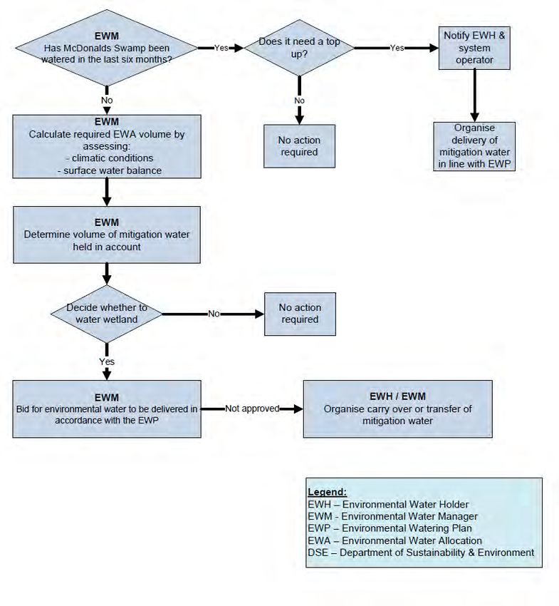
McDonalds Swamp                                                  Environmental Watering Plan

The incidental water at the origin was 121 ML in the baseline year and the annualised
baseline mitigation water volume was calculated as 121 ML. The Mitigation Water
Commitment for McDonalds Swamp is 100%. This will be used to calculate the interim
mitigation water share of any annually calculated water savings.
Potential risks, limiting factors and adverse impacts associated with the desired water
regime
A number of potential risks, limiting factors and adverse impacts have been identified that
may result from the provision of mitigation water as a portion of the desired water regime. An
alternative supply point to McDonalds Swamp may be adopted as part of NVIRP’s
Connections Program. A possible option being considered by NVIRP is providing an
alternative supply point on the western boundary. However experience from delivery of
environmental water has shown that adjoining land is regularly inundated when the wetland is
filled to FSL, a risk to the provision of mitigation water as a component of the desired water
regime.
Infrastructure requirements
Currently, the automated regulator and delivery channel to McDonalds Swamp have a
capacity of 50 ML/day which equates to a minimum of 17 days to fill the wetland from empty,
assuming that no losses occur and operating at full capacity. In 2009 however, with an
average delivery rate of 21 ML/day, believed to be constrained by the siphon passing flows
under the Piccaninny/Barr Drain, it took approximately 42 days to fill the wetland. The current
delivery infrastructure is considered adequate to deliver the desired water regime and no
infrastructure upgrades are recommended as part of NVIRP.
However, NVIRP are currently considering rationalising 9 km of channel 2/3 and providing an
alternative supply point to McDonalds Swamp from either the north or northwest of the
wetland (associated with channel 3/5 or channel 8/1/1, respectively). It is recommended that
channel 2/3 is retained to ensure McDonalds Swamp is able to receive environmental water
until suitable alternative supply arrangements are agreed upon. However, if channel 2/3 is to
be rationalised, NVIRP will be responsible for providing the equivalent capacity of the existing
infrastructure or an agreed delivery rate. An optimal delivery rate of 35 ML/day is
recommended.
Adaptive management framework
An adaptive management approach (assess, design, implement, monitor, review and adjust)
is incorporated into the EWP to ensure that it is responsive to changing conditions.
The McDonalds Swamp EWP has been developed using the best available information.
However, a number of information and knowledge gaps are identified in the document which
may impact recommendations and/or information presented. These knowledge gaps will be
addressed as part of the adaptive management approach outlined within the EWP as
additional information becomes available.
Governance arrangements
A summary of the roles and responsibilities (e.g. land manager, environmental water
manager, and system operator) relating to the development and implementation of EWPs are
defined. A framework for operational management has also been developed to describe the
annual decision-making process required to coordinate the implementation of the desired
water regime for McDonalds Swamp.

                                               ii
McDonalds Swamp                                                                                  Environmental Watering Plan

CONTENTS PAGE
EXECUTIVE SUMMARY............................................................................................................ I
CONTENTS PAGE................................................................................................................... III
ACKNOWLEDGEMENTS ......................................................................................................... V
ABBREVIATIONS .................................................................................................................... VI
1.      NORTHERN VICTORIA IRRIGATION RENEWAL PROJECT........................................ 1
     1.1.     DECISION UNDER THE ENVIRONMENTAL EFFECTS ACT 1978......................................... 1
     1.2.     WATER CHANGE MANAGEMENT FRAMEWORK .............................................................. 1
     1.3.     PURPOSE AND SCOPE OF ENVIRONMENTAL WATERING PLANS ...................................... 2
     1.4.     DEVELOPMENT PROCESS ............................................................................................ 2
        1.4.1.     Consultation and engagement......................................................................... 3
2.      MCDONALDS SWAMP.................................................................................................... 5
     2.1.     WETLAND CONTEXT AND CURRENT CONDITION ............................................................. 5
     2.2.     CATCHMENT SETTING ................................................................................................. 7
     2.3.     LAND STATUS AND MANAGEMENT ................................................................................. 8
     2.4.     CULTURAL HERITAGE .................................................................................................. 8
     2.5.     RECREATION .............................................................................................................. 8
     2.6.     LEGISLATIVE AND POLICY FRAMEWORK ........................................................................ 9
        2.6.1.     International agreements................................................................................. 9
        2.6.2.     Federal legislation ........................................................................................... 9
        2.6.3.     State legislation ............................................................................................... 9
3.      MCDONALDS SWAMP ENVIRONMENTAL VALUES ................................................. 11
     3.1.       FAUNA ..................................................................................................................... 11
     3.2.       FLORA ..................................................................................................................... 12
     3.3.       REPRESENTATIVENESS AND DISTINCTIVENESS ........................................................... 13
4.      HYDROLOGY ................................................................................................................. 14
     4.1.     NATURAL WATER REGIME .......................................................................................... 14
     4.2.     HISTORY OF WATER MANAGEMENT ............................................................................ 14
        4.2.1.     Recorded outfalls and NVIRP........................................................................ 15
     4.3.     SURFACE WATER/GROUNDWATER INTERACTIONS ....................................................... 16
     4.4.     SURFACE WATER BALANCE ........................................................................................ 17
     4.5.     OPERATIONAL USES .................................................................................................. 18
        4.5.1.     Flood mitigation ............................................................................................. 18
        4.5.2.     Drainage ........................................................................................................ 19
5.      MANAGEMENT OBJECTIVES ...................................................................................... 20
     5.1.     WATER MANAGEMENT GOAL ...................................................................................... 20
     5.2.     ECOLOGICAL OBJECTIVES AND HYDROLOGICAL REQUIREMENTS .................................. 20
     5.3.     DESIRED WATER REGIME ........................................................................................... 22
     5.4.     MITIGATION WATER ................................................................................................... 24
        5.4.1.     McDonalds Swamp mitigation water ............................................................. 25
     5.5.     OTHER WATER SOURCES .......................................................................................... 27
        5.5.1.     Murray flora and fauna bulk entitlement ........................................................ 28
        5.5.2.     75 GL environmental entitlement................................................................... 28
        5.5.3.     Commonwealth environmental water ............................................................ 28
6.      POTENTIAL RISKS OR ADVERSE IMPACTS ............................................................. 29
7.      WATER DELIVERY ARRANGEMENTS........................................................................ 30
     7.1.       NVIRP WORKS PROGRAM – CHANNEL 2/3 ................................................................. 30
     7.2.       INFRASTRUCTURE REQUIREMENTS ............................................................................. 31
8.      ADAPTIVE MANAGEMENT FRAMEWORK ................................................................. 32
     8.1.       MONITORING AND REPORTING ................................................................................... 32

                                                                     iii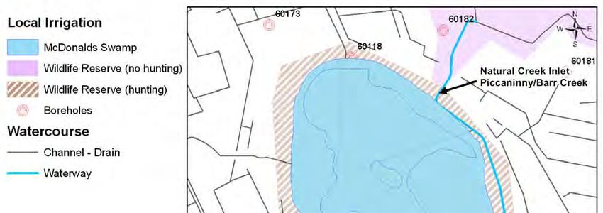
McDonalds Swamp                                                                                 Environmental Watering Plan

     8.2.       REVIEW.................................................................................................................... 33
     8.3.       ADJUSTMENT............................................................................................................ 33
9.     GOVERNANCE ARRANGEMENTS .............................................................................. 34
     9.1.       FRAMEWORK FOR OPERATIONAL MANAGEMENT .......................................................... 37
10.          KNOWLEDGE GAPS................................................................................................. 39
     10.1.      WORKS PROGRAM .................................................................................................... 39
     10.2.      MCDONALDS SWAMP ................................................................................................ 39
     10.3.      ROLES AND RESPONSIBILITIES ................................................................................... 39
11.          REFERENCES ........................................................................................................... 40
APPENDIX A: NVIRP TAC AND WETLAND WORKSHOP PARTICIPANTS....................... 43
APPENDIX B: COMMUNITY INTERACTION/ENGAGEMENT.............................................. 44
APPENDIX C: CONTOUR PLAN AND CAPACITY TABLE .................................................. 47
APPENDIX D: WETLAND CHARACTERISTICS................................................................... 49
APPENDIX E: FLORA AND FAUNA SPECIES LIST ............................................................ 50
APPENDIX F: VEGETATION COMPOSITION MAP – 20 OCTOBER 2009 ......................... 54
APPENDIX G: HYDROLOGY (SWET OUTPUT) ................................................................... 55
APPENDIX H: PRELIMINARY LEAKAGE AND SEEPAGE LOSS CONTRIBUTION
CALCULATIONS .................................................................................................................... 56
APPENDIX I: ADDITIONAL RISKS AND LIMITING FACTORS............................................ 57
APPENDIX J: MONITORING PROGRAM RECOMMENDATIONS....................................... 60
APPENDIX K: CONTOUR AND VEGETATION MAP............................................................ 64

                                                                     iv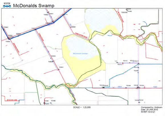
McDonalds Swamp                                                 Environmental Watering Plan

ACKNOWLEDGEMENTS
The information contained in the McDonalds Swamp Environmental Watering Plan (EWP) has
been sourced from a variety of reports and field inspections and from individual knowledge
and expertise.
The North Central Catchment Management Authority (CMA) acknowledges the assistance of
the following people in preparing this EWP.
   •   Rob O’Brien (Department of Primary Industries)
   •   Cherie Campbell, Caitlin Johns, Christine Reid, and Dr Todd Wallace (Murray-Darling
       Freshwater Research Centre)
   •   Geoff Sainty (Sainty Associates)
   •   Shelley Heron (Kellogg Brown and Root)
   •   Stan Archard and Dustin Chislett (Archards Irrigation)
   •   Mark Reid (DPI Primary Industries Research Victoria)
   •   Andrea Joyce, Murray Rhoda and Heath Dunstan (Department of Sustainability and
       Environment)
   •   Mark Tscharke (Parks Victoria)
   •   Ross Stanton (G-MW)
   •   Pat Feehan (Feehan Consulting)
   •   Ross Plunkett, Chris Solum and Mark Paganini (NVIRP)
   •   NVIRP Technical Advisory Committee (listed in Appendix A, Table A1)
   •   Wetland workshop attendees (listed in Appendix A, Table A2)
   •   Ken Lancaster (Landholder)
   •   Betty Waterson and Norma Sheridan (Bird Observation and Conservation Australia)
   •   Graham Hall, Bridie Velik-Lord, Rebecca Horsburgh, Peter McRostie, Lyndall Rowley
       (North Central CMA).

                                             v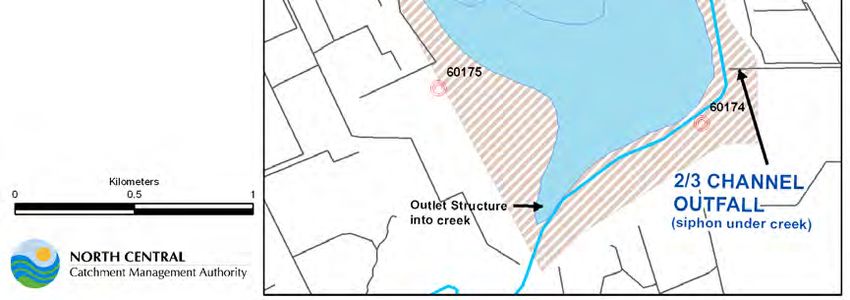
McDonalds Swamp                                             Environmental Watering Plan

ABBREVIATIONS
AAV                 Aboriginal Affairs Victoria
AVW                 Atlas of Victorian Wildlife
ANCA                Australian Nature Conservation Agency
AUSRIVAS            Australian River Assessment System
BE                  Bulk Entitlement
BONN                Convention on the Conservation of Migratory Species of Wild
                    Animals
CAMBA               China–Australia Migratory Bird Agreement
CMA                 Catchment Management Authority
DCFL                Department of Conservation Forests and Lands
DEWHA               Department of the Environment, Water, Heritage and the Arts
DPCD                Department of Planning and Community Development
DPI                 Department of Primary Industries
DSE                 Department of Sustainability and Environment
EES                 Environmental Effects Statement
EPBC                Environment Protection and Biodiversity Conservation Act 1999
ERP                 Expert Review Panel
EVC                 Ecological Vegetation Class
EWH                 Environmental Water Holder
EWP                 Environmental Watering Plan
FFG                 Flora and Fauna Guarantee Act 1988
FIS                 Flora Information System
FSL                 Full Supply Level
GIS                 Geographic Information Systems
GL                  Gigalitre (one billion litres)
GMID                Goulburn Murray Irrigation District
G-MW                Goulburn–Murray Water
JAMBA               Japan–Australia Migratory Bird Agreement
LTCE                Long-term Cap Equivalent
MDFRC               Murray-Darling Freshwater Research Centre
MNES                Matters of National Environmental Significance
North Central CMA   North Central Catchment Management Authority
NVIRP               Northern Victoria Irrigation Renewal Project
ROKAMBA             Republic of Korea–Australia Migratory Bird Agreement
SEMP                Site Environmental Management Plan
TAC                 Technical Advisory Committee
TIS                 Torrumbarry Irrigation System
VEAC                Victorian Environmental Assessment Council
VROTS               Victorian Rare or Threatened Species

                                            vi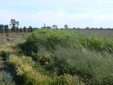
McDonalds Swamp                                                  Environmental Watering Plan

1. Northern Victoria Irrigation Renewal Project
The Northern Victoria Irrigation Renewal Project (NVIRP) is a $2 billion works program to
upgrade ageing irrigation infrastructure across the Goulburn Murray Irrigation District (GMID)
and to save water lost through leakage, seepage, evaporation and system inefficiencies.
Works will include lining and automating channels, building pipelines and installing new,
modern metering technology. These combined works will improve the irrigation system’s
delivery efficiency and recover a long term average (LTCE) of 425 GL of water per year.
The GMID uses a number of natural carriers, rivers, lakes and wetlands for both storage and
conveyance of water. While the water savings generated are from ‘losses’ within the irrigation
system, in some cases the losses from the pre-NVIRP operating regime provides incidental
benefits to environmental assets (SKM 2008).

    1.1. Decision under the Environmental Effects Act 1978
On the 14 April 2009, the Minister for Planning made a decision that an Environment Effects
Statement (EES) was not required for the NVIRP, although this decision was subject to
several conditions (DPCD 2009). The conditions that apply to the protection of wetlands and
waterways include:
Condition 3: development of a framework for protection of aquatic and riparian ecological
values through management of water allocations and flows within the modified GMID system
to the satisfaction of the Minister of Water
NVIRP have developed a Water Change Management Framework (NVIRP 2010) in response
to this condition. The framework outlines the processes and methods for preparing
Environmental Watering Plans (EWPs) to mitigate potential impacts on wetlands and
waterways at risk from the implementation of the NVIRP through adaptive water management
(NVIRP 2010).
Condition 5: Environmental Watering Plans are required for ‘at risk’ waterways and wetlands
before operation of the relevant NVIRP work commences

    1.2. Water Change Management Framework
The Water Change Management Framework (NVIRP 2010) sets out the overarching key
principles with respect to environmental management for the operation of the modified GMID.
These principles include:
    •   NVIRP will strive for efficiency in both water supply and farm watering systems.
    •   NVIRP will design and construct the modernised GMID system to comply with
        environmental requirements as specified in the no-EES conditions.
    •   NVIRP will develop management and mitigation measures consistent with
        established environmental policies and programs in place in the GMID.
    •   Renewal or refurbishment of water infrastructure will be undertaken to the current
        best environmental practice, including any requirements to better provide
        environmental water. Best environmental practice will require irrigation infrastructure
        required to deliver environmental water to be retained (no rationalisation at these
        sites) or upgraded to allow for future use.
    •   Management and mitigation measures will be maintained into the future through
        establishment of or modification to operating protocols and operational arrangements.
In October 2008, the Food Bowl Modernisation Project Environmental Referrals Report
(SKM 2008) assessed Stage 1 (upgrade of the backbone and connections) of the NVIRP in
relation to operational impacts on waterways, wetlands and regional groundwater from
increased system efficiencies such as changes in channel outfalls, delivery patterns and
reductions in leakage and seepage.

                                              1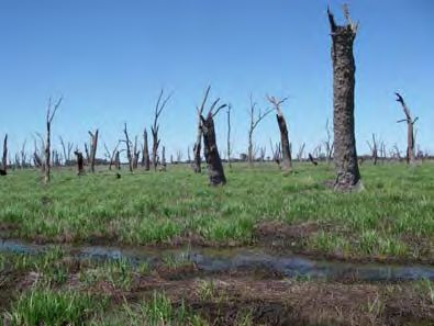
McDonalds Swamp                                                   Environmental Watering Plan

SKM (2008) prioritised 10 wetlands and four rivers with significant environmental values that
may be impacted by the NVIRP, particularly by significant reductions in channel outfalls
across the GMID. The 10 wetlands are:
    •   Lake Elizabeth                                  •    Lake Meran
    •   Lake Murphy                                     •    Little Lake Meran
    •   Johnson Swamp                                   •    Lake Leaghur
    •   McDonalds Swamp                                 •    Lake Yando
    •   Round Lake                                      •    Little Lake Boort
The above wetlands are located within the North Central CMA region and require the
development of an EWP. The Johnson Swamp EWP, and Interim Lake Murphy and Lake
Elizabeth EWPs were completed prior to the operation of NVIRP works in the 2009-2010
irrigation season.
While NVIRP has been established to implement the modernised works, it will have no
ongoing role in the operation of the modified GMID or environmental management in the
region. Therefore NVIRP will need to establish effective management arrangements to ensure
that any management or mitigation measures are implemented on an ongoing basis,
particularly in the EWPs (NVIRP 2010).

    1.3. Purpose and scope of Environmental Watering Plans
The EWPs are the primary means by which the commitment of no net environmental loss will
be achieved for water savings projects (NVIRP 2010). Each EWP will:
    •   identify environmental values of the wetland
    •   identify the water required to protect the environmental values
    •   define the environmental water regime and the sources of water
    •   identifying if there is a need to provide mitigation water and, if so, determine the
        quantification of mitigation water
    •   identify the infrastructure requirements
    •   identify mitigation measures to minimise the potential risks and impacts associated
        with the provision of mitigation water
    •   draft protocols for ongoing water supply
    •   outline governance arrangements.
This EWP is not a wetland management plan, therefore it is not intended to provide
management guidance for wetlands; rather it is aimed at providing a water supply protocol
that can be agreed upon by land, water and catchment managers.
NVIRP is responsible for managing and mitigating the significant environmental effects of its
own activities. It is not responsible for managing and mitigating the effects of other activities
or circumstances. NVIRP is not responsible for managing and mitigating the environmental
effects of activities or circumstances beyond its control such as:
    •   reduced outfalls due to Government policy initiatives
    •   water trade
    •   drought and climate change
    •   management and modernisation programs carried out by others (NVIRP 2010)

    1.4. Development process
The McDonalds Swamp EWP was developed in collaboration with key stakeholders including
Goulburn–Murray Water (G-MW), NVIRP, the Department of Sustainability and Environment
(DSE), Parks Victoria and the Department of Primary Industries (DPI) according to the

                                               2
McDonalds Swamp Environmental Watering Plan
process outlined in Figure 1. A number of tasks were undertaken to develop the EWP, as
follows:
• scoping and collating information
• defining ecological objectives and associated water requirements
• identifying risks and threats
• identifying need to provide mitigation water and, if needed, determine the
quantification of mitigation water
• assessing infrastructure requirements
• developing recommendations on governance arrangements and adaptive
management
• consulting and engaging stakeholders and adjacent landholders.
Following development, EWPs will be reviewed by the DSE Approvals Working Group
(membership comprised of departmental representatives) and the Expert Review Panel
(ERP) prior to consideration by the Minister for Water.
Figure 1: EWP development process
1.4.1. Consultation and engagement
To assist in collating information for the McDonalds Swamp EWP, a targeted community and
agency engagement process was undertaken. Key groups consulted were the NVIRP
Technical Advisory Committee (TAC), agency stakeholders, interest groups and adjoining
landholders. An outline of the various groups’ involvement is provided below.
3McDonalds Swamp Environmental Watering Plan
The TAC was convened by the NVIRP to oversee the development of the EWPs to ensure
quality, completeness and practicality. The committee includes representation from CMAs,
G-MW, DPI, NVIRP and DSE (Appendix A). A content template for the EWPs was developed
and approved by the TAC.
A workshop was held on 17 December 2009 with key agency stakeholders and technical
experts (Appendix A) in order to discuss and refine the water management goal, ecological
objectives, and water requirements for McDonalds Swamp.
Consultation was also undertaken with adjoining landholders (18 January 2010) who have
had a long association with the wetland and proven interest in maintaining its environmental
value. Other community and agency people were directly engaged to provide technical and
historic information, including G-MW staff and bird observers. A summary of the information
sourced from this process is provided in Appendix B.
4McDonalds Swamp Environmental Watering Plan
2. McDonalds Swamp
McDonalds Swamp is situated approximately 13 km east of Kerang and 10 km west of the
Murray River (Figure 2). The wetland is traversed by the Piccaninny/Barr Drain which
separates it into McDonalds Swamp East and McDonalds Swamp West (Appendix C). The
EWP addresses McDonalds Swamp West only, which receives G-MW channel outfall water.
McDonalds Swamp is of bioregional conservation significance (NLWRA 2002, cited in
NCCMA 2005) due largely to the waterbird habitat values supported by the wetland
(SKM 2008).
McDonalds Swamp occupies approximately 164 ha of a 215 ha Crown land reserve2
(Archards Irrigation 2010). It has a full supply level (FSL) of 75.50 m AHD at which height the
storage capacity in McDonalds Swamp is 872 ML with a maximum depth of 80 cm (Archards
Irrigation 2010).
Refer to Appendix C for the contour plan prepared for McDonalds Swamp by Archards
Irrigation (2010).
Figure 2: Location of McDonalds Swamp
2.1. Wetland context and current condition
Prior to European settlement, McDonalds Swamp was a shallow freshwater marsh3
dominated by River Red Gums (DSE 2009a). It would naturally have received floodwaters
from Piccaninny/Barr Creek when Gunbower Creek was running high (Appendix B). Naturally,
flows would enter Red Gum Swamp 500 m to the northeast, then McDonalds Swamp and
Barr Creek. Groundwater levels were probably 10 to 20 m below the surface, with McDonalds
Swamp acting as a temporary source of groundwater recharge (SKM 2001).
The establishment of the Torrumbarry Irrigation System in the 1920s, construction of levees
across the floodplain and the dredging of the Piccaninny/Barr Creek in the 1960s have
resulted in significant changes to the hydrology of the wetland. McDonalds Swamp can no
2
The Wetsys Database formerly reported that McDonalds Swamp occupies 366 ha. This area appears to include the
public land reserves of both McDonalds Swamp and Red Gum Swamp to the north east.
3
Shallow freshwater marshes are generally less than 0.5 m deep and are inundated for less than 8 months of the
year (DCFL 1989).
5McDonalds Swamp Environmental Watering Plan
longer receive water from the Piccaninny/Barr Creek. However, end of irrigation season
channel outfalls, irrigation drainage inflows and rainfall rejection flows delivered via channel
2/3 resulted in a more permanent system (SKM 2001 and Appendix B). Following
development of the irrigation system, groundwater levels within the Kerang region rose
dramatically to within 80 cm of the surface (SKM 2001; Bartley Consulting 2009).
Hydrological change has been accompanied by changing land use within the area. Although
once surrounded by dairy farms, adjacent land use now consists primarily of broadacre
dryland agriculture (pers. comm. Rob O’Brien [DPI], 19 November 2009).
Stags remain as evidence of the River Red Gums that once dominated the wetland. They are
thought to have died in the late 1800s as a result of prolonged inundation (>3 years) and a
period of elevated salinity levels (pers. comm. Stan Archard [Archards Irrigation], 18 January
2010). Only a few regenerating River Red Gums currently exist within the wetland but appear
to be in good health (Campbell et al. 2009).
Following establishment of the irrigation system McDonalds Swamp received significant
volumes of outfall water, rarely drying out (pers. comm. Rob O’Brien [DPI], 8 February 2010).
In more recent times channel outfalls reduced dramatically and there was a requirement to
utilise environmental water (discussed further in Section 4).
During the recent dry phase between 2006/07 and 2007/08 a large proportion of the wetland
floor supported a range of common weed species including Wild Lettuce (Lactuca sp.) and
Brassica sp. These annual weeds are pioneer species and may reduce over time as natives
re-establish (pers. comm. Rob O’Brien [DPI] 8 February 2010).
It was recently inundated resulting from the provision of environmental water in autumn and
spring of 2009 from the Murray Flora and Fauna Entitlement. Consequently, the wetland
currently supports open water, with Tall Marsh (EVC 821), Aquatic Sedgeland (EVC 308) and
Spike-sedge Wetland (EVC 819) vegetation (Section 3) with abundant dead standing (and
fallen) timber.
A condition assessment undertaken on 20 October 2009 reported that McDonalds Swamp
continues to display a diverse range of species and habitat for which the wetland is highly
valued (Campbell et al. 2009). The main habitat components currently provided by
McDonalds Swamp are summarised below:
• Open water (Plate 1) and fringing mudflat habitat. However, open water segments
supported very little to no aquatic vegetation. Only floating fragments of Water-milfoil
(Myriophyllum sp.) were observed.
• Extensive stands of dense Cumbungi (Typha sp.) and Common Reed (Phragmites
australis.) exist to the south-east within the vicinity of the current channel outfall
(Plate 2). In addition, Cumbungi is scattered across McDonalds Swamp with large
stands also persisting towards the western boundary in association with a small drain
(8/1/1).
• A range of sedges are sustained by shallow inundation and waterlogged mud to the
south and west (Plate 3). Species observed include Common Spike-sedge
(Eleocharis acuta), Salt Club-sedge (Bolboschoenus caldwellii), and Rush (Juncus
sp.). Black Box (Eucalyptus largiflorens) and Tangled Lignum (Muehlenbeckia
florulenta), which are characteristic species of Riverine Chenopod Woodland
(EVC 103), exist to the south-east and a small patch of Tangled Lignum currently
persists to the north.
• The wetland is fringed along the western boundary by salt-tolerant species dominated
by Blackseed Glasswort (Halosarcia pergranulata ssp. pergranulata) (Plate 4).
• The eastern verge, particularly the road and levee, is highly degraded and supports a
range of exotic species including a number of moderate to high threat species. Those
observed include Spear thistle (Cirsium vulgare), Patersons Curse (Echium
plantagineum), African Boxthorn (Lycium ferocissimum), Horehound (Marrubium
vulgare), Sweet Briar (Rosa rubiginosa) and Variegated Thistle (Silybum marianum).
6McDonalds Swamp Environmental Watering Plan
Ultimately, historically and in more recent years, McDonalds Swamp has provided a diversity
of habitat types which in turn attracts a variety of native fauna, particularly waterbirds
(Section 3).
A summary of the wetland characteristics is provided in Appendix D.
Plate 1: Open water and dead standing timber Plate 2: Dense Phragmites in southeast corner
(Source: MDFRC 2009) (Source: MDFRC 2009)
Plate 3: Salt-club Sedge zone (Source: Plate 4: Samphire shrubland on western
MDFRC 2009) margin (Source: MDFRC 2009)
2.2. Catchment setting
McDonalds Swamp is located in the Piccaninny/Barr Creek sub-catchment which occurs on
the floodplains of the Loddon, Murray and Avoca Rivers (SKM 2001). It is situated within the
Murray Fans bioregion. The local catchment area is low-lying and prone to flooding which has
resulted in the deposition of rich, generally impermeable sediments (SKM 2001). It is likely
that it flooded in moderate to high flood events in the Murray River prior to the construction of
levees and drains across the floodplain (pers. comm. Graham Hall [NCCMA], 25 January
2010). Water flooded from the Murray River into Gunbower Creek and via Piccaninny Creek
through Red Gum Swamp and McDonalds Swamp.
The Piccaninny/Barr Creek has an estimated local catchment area of 6,400 ha. However, the
dredging of the creek disconnected the wetland from its natural flow path. A small area to the
west of McDonalds Swamp (~100ha) constitutes the wetland’s local catchment area and is
drained by channel 8/1/1 (Appendix B). As mentioned above, surrounding land use now
consists primarily of broadacre dryland agriculture (pers. comm. [DPI] Rob O’Brien, 19
November 2009).
Rainfall in the Kerang region averages 377 mm/year, with May to October being significantly
wetter than November to April (Macumber 2002). Maximum average temperatures range from
31.5°C in January to 14°C in July, with minimum average temperatures falling to 4°C in July
(Bureau of Meteorology 2009).
McDonalds Swamp is connected to the Torrumbarry Irrigation System via channel 2/3
(Figure 3) and has received significant channel outfalls over time, sometimes in excess of
7McDonalds Swamp Environmental Watering Plan
40% of the wetland capacity in any one year (Section 4). In addition, the wetland has received
significant environmental water in eight years between 1998 and 2010.
Figure 3: Inflow points at McDonalds Swamp
2.3. Land status and management
McDonalds Swamp is a State Wildlife Reserve under the Crown Land (Reserves) Act 1978
and is managed by Parks Victoria under the Wildlife Act 1975. Wildlife reserves are managed
primarily for the conservation of native wildlife but allow recreational and educational use so
long as it doesn’t conflict with the primary aim (LCC 1988).
In 2009, the Victorian government endorsed (with amendments) the Victorian Environment
Assessment Council (VEAC) recommendations for public land management. McDonalds
Swamp will remain as a wildlife reserve under the “state game reserve” classification. A series
of VEAC recommendations relating to the establishment of National Parks will take effect on
29 June 2010. However, the proclamation date for all other areas (wildlife reserves, nature
conservation reserves, etc) is yet to be determined (pers. comm. Doug Hooley [DSE], 20 May
2010). Wildlife reserves will be managed to conserve and protect species, communities or
habitats of indigenous animals and plants while permitting recreational (including hunting in
season as specified by the land manager) and educational use (VEAC 2008; DSE 2009c).
2.4. Cultural heritage
The Kerang Lakes area is known to be one of the most archaeologically significant areas
within Victoria. Numerous large cooking mounds once fringed the wetland however many
were scalped off and removed during early European settlement (pers. comm. Rob O’Brien
[DPI], 8 February 2010). Five mounds have been recorded in the Red Gum
Swamp/McDonalds Swamp area and are registered with Aboriginal Affairs Victoria (AAV).
Further information can be obtained from AAV.
2.5. Recreation
McDonalds Swamp is a valuable wetland for recreation within the Kerang Lakes area. The
wetland supports:
• hunting
• bird watching (SKM 2001).
8McDonalds Swamp Environmental Watering Plan
2.6. Legislative and policy framework
2.6.1. International agreements
Australia is a signatory to the following international migratory bird agreements:
• Japan–Australia Migratory Bird Agreement (JAMBA)
• China–Australia Migratory Bird Agreement (CAMBA)
• Republic of Korea–Australia Migratory Bird Agreement (ROKAMBA)
• Convention on the Conservation of Migratory Species of Wild Animals (also known as
the Bonn Convention).
McDonalds Swamp is known to support species protected by each of the above international
migratory bird agreements (Table 1). As wetland habitat for a number of protected species,
McDonalds Swamp is required to be protected and conserved in accordance with these
international agreements (DEWHA 2009).
2.6.2. Federal legislation
The Environment Protection and Biodiversity Conservation (EPBC) Act 1999 is the key piece
of legislation pertaining to biodiversity conservation within Australia. It aims to control potential
impacts on matters of national environmental significance (MNES)4.
McDonalds Swamp is known to support protected migratory waterbirds, some of which are
also listed under the EPBC Act (Table 1). Actions that may significantly impact any of these
MNES are subject to assessment and approval by the Minister for the Environment, Heritage
and the Arts. The NVIRP works program is also subject to assessment and approval under
the EPBC Act.
2.6.3. State legislation
Flora and Fauna Guarantee (FFG) Act 1988
The Flora and Fauna Guarantee (FFG) Act 1988 aims to protect a number of identified
threatened species and communities within Victoria. McDonalds Swamp is known to support
a number of species both protected5 and listed under the FFG Act (Table 1 and Table 3).
Disturbance or collection of any of these threatened species will require a permit from the
DSE.
Environmental Effects Act 1978
Potential environmental impacts of a proposed development are subject to assessment and
approval under the Environmental Effects Act 1978. As such, the NVIRP works program and
any associated environmental impacts are subject to assessment and approval under the Act
(as discussed in Section 1.1).
Planning and Environment Act 1987
The removal or disturbance to native vegetation within Victoria is controlled by the
implementation of a three-step process of avoidance, minimisation and offsetting under the
Planning and Environment Act 1987. Any proposed removal or disturbance to native
vegetation associated with the NVIRP works program will require the implementation of the
three-step process, assessment and approval under the Act.
Water Act 1989
The Water Act 1989 is the key piece of legislation that governs the way water entitlements are
issued and allocated in Victoria. The Act also identifies water that is to be kept for the
environment as part of the Environmental Water Reserve. The Act provides a framework for
defining and managing Victoria’s water resources.
4
There are seven MNES that are protected under the EPBC Act, these are: World Heritage properties, National
Heritage places, wetlands of international importance, listed threatened species and ecological communities,
migratory species protected under international agreements, Commonwealth marine areas, and nuclear actions
(including uranium mines) (DEWHA 2009).
5
Includes plant taxa belonging to families or genera protected by the Act (DSE 2009d).
9McDonalds Swamp Environmental Watering Plan
Aboriginal Heritage Act 2006
All Aboriginal places, objects and human remains in Victoria are protected under the
Aboriginal Heritage Act 2006 (DPCD 2007). McDonalds Swamp is known to support sites of
Aboriginal cultural significance (Section 3.2).
Other - Threatened Species Advisory Lists
Threatened species advisory lists for Victoria are maintained by the DSE and are based on
technical information and advice obtained from a range of experts which are reviewed every
one to two years. These advisory lists are not the same as the Threatened List established
under the FFG Act. There are no legal requirements or consequences that flow from inclusion
of a species in advisory lists. However, some of the species in these advisory lists are also
listed as threatened under the FFG Act. McDonalds Swamp is known to support flora and
fauna species that are included on advisory lists (Table 1 and Table 3).
10McDonalds Swamp Environmental Watering Plan
3. McDonalds Swamp environmental values
The primary purpose of this EWP is to assess and advise on mitigating potential impacts on
high environmental values supported by McDonalds Swamp. While it is recognised that the
wetland provides a number of broader ecological and landscape values (i.e. ecological
processes, representativeness and distinctiveness in landscape), high environmental values
have previously been defined by the conservation significance of the wetland or species at an
international, national or state level (SKM 2008; NVIRP 2010).
As such, in describing the values supported by the wetland in the sections below, an
emphasis is placed on identifying listed flora and fauna species, and vegetation communities
followed by the broader ecological and landscape values. All listed values have been
presented in this section with full species lists provided in Appendix E.
McDonalds Swamp is considered a high value wetland because of its large size, habitat and
species diversity, waterbird carrying capacity, and ability to provide drought refuge. In
addition, the wetland is known to support a significant diversity and abundance of
microorganisms and invertebrates.
3.1. Fauna
As discussed in Section 2.1, McDonalds Swamp provides a diverse array of habitat types
including mudflats, open water, reeds, and dead River Red Gums which in turn attract a
range of fauna species. The wetland is known to be extremely productive for waterbird use
and breeding, with regular nesting reported over time (SKM 2001). For example, numerous
Black Swans (Cygnus atratus) were observed to have bred and Grey Teal (Anas gracilis)
were observed in their thousands following recent watering (pers. comm. Paul David
[Landholder], 11 January 2010). Tree hollows situated within the wetland also provide
important breeding habitat for a variety of species (including Australian Wood Duck
(Chenonetta jubata), Grey Teal and Chestnut Teal (Anas castanea).
McDonalds Swamp provides important open water and mudflat habitat for migratory waders.
McDonalds Swamp, in conjunction with Johnson Swamp, Hirds Swamp and Lake Murphy,
offer extensive mudflat habitat that is not offered by the more permanent lakes within the
Kerang region (pers. comm. Betty Waterson [BOCA], 18 January 2010).
More than 80 bird species have been recorded within McDonalds Swamp with records
indicating that 16 are of conservation significance at an international, national and/or state
level (Table 1 and Appendix E).
Table 1: Significant fauna species recorded in McDonalds Swamp
International EPBC FFG DSE
Common Name Scientific Name treaty status status status
Australasian Shoveler Anas rhynchotis VU
Australian Painted
Snipe Rostratula australis C VU L CR
Clamorous Reed
Warbler Acrocephalus stentoreus B
Common
Greenshank Tringa nebularia B/C/J/R
Eastern Great Egret Ardea modesta C/J L VU
Freckled Duck Stictonetta naevosa L EN
Glossy Ibis Plegadis falcinellus C NT
Grey-crowned Pomatostomus
Babbler temporalis L EN
Hardhead Aythya australis VU
Intermediate Egret Ardea intermedia L CR
Musk Duck Biziura lobata VU
Nankeen Night Heron Nycticorax caledonicus NT
Royal Spoonbill Platalea regia VU
Sharp-tailed
Sandpiper Calidris acuminata B/C/J/R
Whiskered Tern Chlidonias hybridus NT
11McDonalds Swamp Environmental Watering Plan
International EPBC FFG DSE
Common Name Scientific Name treaty status status status
White-bellied Sea-
Eagle Haliaeetus leucogaster C L VU
Conservation Status:
• J/C/R/B: JAMBA/CAMBA/ROKAMBA/BONN International agreements listed in section 2.3.1
• EPBC Listed: VU – Vulnerable
• FFG listing: L – Listed as threatened
• DSE listing: CR – Critically Endangered, EN – Endangered, VU – Vulnerable, NT – Near
Threatened (DSE 2007a)
3.2. Flora
According to DSE’s pre-1750 ecological vegetation class (EVC) mapping, prior to European
settlement McDonalds Swamp was dominated by Lignum Swampy Woodland (EVC 823) and
surrounded by Riverine Grassy Woodland (EVC 295) and Riverine Chenopod Woodland
(EVC 103) vegetation (DSE 2009e). Lignum Swampy Woodland EVC is described as:
‘Tall, mostly dense shrub layer, dominated by Tangled Lignum, in association with a
Eucalypt/Acacia low woodland. The ground-layer includes a component of obligate wetland
flora that is able to persist (even if dormant) over dry periods’. Characteristic Eucalypt species
within this EVC are River Red Gum and Black Box (DSE 2009f)
DSE’s 2005 EVC mapping suggests that the above EVCs are still present; however Riverine
Grassy Woodland (EVC 295) and Riverine Chenopod Woodland (EVC 103) are diminished in
extent (DSE 2009g).
DSE’s 2005 EVC mapping has been collected via aerial photograph interpretation,
biophysical data and selective ground truthing of sites on a project-by-project basis over a
number of years (DSE 2007b).
However, assessments undertaken by the Murray-Darling Freshwater Research Centre
(Campbell et al. 2009) on 20 October 2009 identified that the wetland is currently
characterised by open water with Tall Marsh (EVC 821), Aquatic Sedgeland (EVC 308) and
Spike-Sedge Wetland (EVC 819) vegetation fringed by Samphire Shrubland (EVC 101) and a
small patch of Riverine Chenopod Woodland (EVC 103) vegetation. These vegetation
communities provide a diversity of habitat types that attract a range of fauna species. The
results of the assessment show a marked difference to the mapped 2005 EVCs and are
based on recently mapped, up-to-date and field verified information. Therefore, the EVCs
reported by MDFRC are included within the EWP as opposed to the mapped 2005 EVCs.
Table 2 identifies the conservation status of the observed and mapped EVCs within
McDonalds Swamp. Refer to Appendix E for a detailed map of EVCs observed in October
2009.
Table 2: Current EVCs within McDonalds Swamp and their conservation status (Campbell et
al. 2009)
EVC No. EVC Bioregional Conservation Status*
821 Tall Marsh Least Concern
308 Aquatic Sedgeland Vulnerable
819 Spike-sedge Wetland Vulnerable
101 Samphire Shrubland Least Concern
103 Riverine chenopod woodland Endangered
*
Murray Fans Bioregion
Four Victorian rare or threatened flora species (VROTS) have been recorded at McDonalds
Swamp (Table 3 and Appendix E). Of these, Peppercress (Lepidium sp) and Black Roly-poly
(Sclerolaena muricata) have a ‘poorly known’ status within Victoria (SKM 2001; DSE 2005a).
VEAC (2008) identified Native Peppercress as a rare or threatened flood dependent flora
species. Branching Groundsel (Senecio cunninghamii var. cunninghamii) is rare within
Victoria and is protected by the FFG Act as it is part of the Asteraceae family. Similarly,
Lemon Beauty-heads (Calocephalus citreus) is protected by the FFG Act as it is part of the
Asteraceae family (DSE 2009d).
12McDonalds Swamp Environmental Watering Plan
Table 3: Significant flora species recorded at McDonalds Swamp
FFG DSE
Common name Scientific Name EPBC status status status
Black Roly-poly Sclerolaena muricata k
Senecio cunninghamii var.
Branching Groundsel cunninghamii P r
Flat Spike-sedge Eleocharis plana v
Lemon Beauty-heads Calocephalus citreus P
Peppercress Lepidium sp. k
Conservation Status:
• FFG listing: L – Listed as threatened, P – Protected
• DSE listing: r – rare, v – vulnerable, k – poorly known and suspected, but not definitely known,
to belong to one of the categories (x, e, v or r) within Victoria (DSE 2005a).
3.3. Representativeness and distinctiveness
According to DSE’s interactive mapping tool, McDonalds Swamp is currently classified as a
deep freshwater marsh6. However, given it has a maximum depth of only 80 cm and holds
water for less than eight months it is considered to more appropriately represent a shallow
freshwater marsh. Shallow freshwater marshes are often degraded as a result of agricultural
activities, including grazing or cropping, and have subsequently decreased in extent across
the landscape. The area of shallow freshwater marshes across Victoria is estimated to have
decreased by approximately 60% since European settlement (DNRE 1997). Table 4
illustrates the area and proportion of shallow freshwater marshes across various defined
landscapes. McDonalds Swamp is an example of the second most depleted wetland category
within Victoria following the shallow freshwater marsh.
Table 4: Current area of deep freshwater marsh wetlands across the landscape
North Central region GMID Victorian Riverina
Shallow freshwater 7297 1085 6724
marshes (ha)
McDonalds Swamp 2% 15% 2%
McDonalds Swamp is distinctive because of its size. The wetland occupies 164 ha and is
situated on a 215 ha crown land reserve which is considered large in comparison to other
wetlands within the North Central region. Only 6% of wetlands within the region are greater
than 100 ha in size (NCCMA 2005).
6
Deep freshwater marshes are generally less than 2 m deep and are inundated for longer than 8 months of the year
(DCFL 1989)
13McDonalds Swamp Environmental Watering Plan
4. Hydrology
Wetland hydrology is the most important determinant in the establishment and maintenance
of wetland types and processes. It affects the chemical and physical attributes of a wetland,
which in turn affects the type of values the wetland supports (DSE 2005b). A wetland’s
hydrology is determined by surface and groundwater inflows and outflows, in addition to
precipitation and evapotranspiration (Mitsch and Gosselink 2000 in DSE 2005b). Duration,
frequency and seasonality (timing of inundation) are the main components of the hydrologic
regime for wetlands.
4.1. Natural water regime
McDonalds Swamp is located within the Piccaninny/Barr Creek sub-catchment which occurs
on the floodplains of the Loddon, Murray and Avoca Rivers (SKM 2001). Its natural water
supply would have been intermittent floods from the Piccaninny/Barr Creek when Gunbower
Creek was running high (Appendix B). It would have been inundated in winter and spring, with
draw-down resulting from evaporation.
The Piccaninny/Barr Creek has an estimated local catchment area of 6,400 ha (pers. comm.
Graham Hall [NCCMA], 19 January 2010). Naturally, runoff would flow into Red Gum Swamp,
then into McDonalds Swamp and Barr Creek.
4.2. History of water management
Construction of the Torrumbarry Irrigation System in the early 1920s, levee and flood
protection measures, and the dredging of the Piccaninny/Barr Creek in the 1960s
disconnected the wetland from its natural flow path. As such, a small local catchment area of
~100 ha situated to the west of the wetland provides runoff (Appendix B). In the past, end of
season channel outfalls, irrigation drainage inflows and rainfall rejection flows provided by
channel 2/3 resulted in an almost permanent system (SKM 2001 and Appendix B).
Surface water data collected by DPI between 1990 and 2007 has several gaps in the
monitoring record prior to 1997/1998. However, it illustrates the water regime experienced by
McDonalds Swamp in more recent years (Figure 4).
Since 1998, McDonalds Swamp has received significant volumes of environmental water
largely to compensate for declining outfalls resulting from increased irrigation efficiencies and
declining regional rainfall volumes (Figure 5 and Table 5). The water regime shifted from
permanent inundation to a seasonal regime that is alternatively wet and dry every year
according to season. However, it experienced a prolonged dry period between 2006/07 and
2008/09.
MCDONALDS SWAMP - Depth and salinity levels
Surface water level (m AHD) Salinity (uS/cm)
80 14000
70 12000
Surface water level (m AHD)
60
10000
Salinity (uS/cm)
50
8000
40
6000
30
4000
20
10 2000
0 0
2
94
95
96
97
98
99
00
01
90
03
03
91
92
93
04
05
06
07
00
19
19
19
19
19
19
20
20
19
19
19
19
20
20
20
20
20
20
/2
3/
2/
3/
2/
7/
4/
7/
8/
7/
9/
6/
5/
4/
2/
9/
6/
5/
4/
11
/0
/0
/0
/1
/0
/0
/0
/0
/0
/0
/0
/0
/0
/1
/0
/0
/0
/0
4/
16
20
30
22
13
28
30
17
31
19
25
20
30
16
13
20
16
30
Figure 4: Surface water and salinity levels within McDonalds Swamp as recorded by DPI
between 1990 and 2007
14You can also read