PAPAKURA TO DRURY SOUTH STAGE 1B1 - Coastal Processes Assessment - EPA NZ
←
→
Page content transcription
If your browser does not render page correctly, please read the page content below
The

 PAPAKURA TO DRURY SOUTH
 STAGE 1B1
 Coastal Processes Assessment
 Revision No: 4
 Published Date: 9/06/2021
 Author: RG Bell (NIWA)
Copyright information

Copyright ©. This copyright work is licensed under the Creative Commons Attribution 4.0 International licence. In
essence, you are free to copy, distribute and adapt the work, as long as you attribute the work to the NZ Transport
Agency and abide by the other licence terms. To view a copy of this licence, visit
http://creativecommons.org/licenses/by/4.0/.

Disclaimer

The NZ Transport Agency has endeavoured to ensure the material in this document is technically accurate and
reflects legal requirements. However, the document does not override governing legislation. The NZ Transport
Agency does not accept liability for any consequences arising from the use of this document. If the user of this
document is unsure whether the material is correct, they should refer directly to the relevant legislation and contact
the NZ Transport Agency.

More information

NZ Transport Agency
June 2021

If you have further queries, call our contact centre on 0800 699 000 or write to us:

NZ Transport Agency
Private Bag 6995
Wellington 6141

This document is available on the NZ Transport Agency’s website at http://www.nzta.govt.nz
Document Control

 Rev Date Description Author Reviewer Verifier Approver
 No

 1 11/09/2020 Draft for skewed bridge pile Dr RG Bell
 option (NIWA)

 2 14/09/2020 Draft for revised bridge pier Dr RG Bell Dr MJ Allis
 location (NIWA) (NIWA)

 3 30/10/2020 Final Dr RG Bell Dr MJ Allis
 (NIWA) (NIWA)

 4 9/6/2021 Final (minor formatting edits) Dr RG Bell Dr MJ Allis Dr SA
 (NIWA) (NIWA) Stephens
 (NIWA)

This document remains the property of Waka Kotahi NZTA, Papakura to Drury South (P2DS) Project. Its contents
are confidential and shall not be reproduced, destroyed, or given away without the express, written permission of
Waka Kotahi NZTA, Papakura to Drury South (P2DS) Project. The electronic version of this document in Geodocs
on the designated server(s) is the Master Copy and is a controlled document. Unless specifically noted thereon,
other copies of this document are uncontrolled.
CONTENTS
1 Introduction ............................................................................................................. 1

1.1 Papakura to Bombay Project Background ................................................................. 1
1.2 Stage 1B1 Papakura to Drury Interchange ................................................................ 1
1.3 Purpose of this Report ............................................................................................... 2
1.4 Statutory Requirements ............................................................................................. 4
1.4.1 COVID-19 Recovery (Fast-track Consenting) Act 2020 ............................................. 4
1.4.2 The New Zealand Coastal Policy Statement .............................................................. 4
1.4.3 The National Policy Statement for Freshwater Management 2020 ............................ 6
1.4.4 Part II (RMA) ............................................................................................................. 7

2 Existing and Future Environment .......................................................................... 8

3 Assessment of Effects .......................................................................................... 12

3.1 Assessment scope and criteria ................................................................................ 12
3.2 Effects of temporary construction, demolition and declamation of the Jesmond Bridge
 on coastal physical processes ................................................................................. 16
3.2.1 Functioning of geomorphic and hydrodynamic processes........................................ 16
3.2.2 Sediment disturbances in the coastal environment .................................................. 17
3.2.3 Discharges to the coastal environment .................................................................... 18
3.3 Operational effects of Stage 1B1 during the operational life-cycle on coastal
 processes ................................................................................................................ 19
3.3.1 Physical encroachment and flow impedance of the coastal environment ................. 20
3.3.2 Ongoing influences or changes to coastal processes .............................................. 25
3.4 Climate-change and coastal flooding effects ........................................................... 30

4 Recommendations ................................................................................................ 35

4.1 Short-term effects during the construction and demolition phase ............................. 35
4.2 Long-term operational lifecycle effects..................................................................... 35
4.2.1 Physical encroachment of Ngakoroa Stream flow .................................................... 35
4.2.2 Bridge sub-structures and rip-rap ............................................................................ 36
4.2.3 Stormwater outlets................................................................................................... 36
4.3 Overall recommendations ........................................................................................ 36

5 Conclusion ............................................................................................................. 38

Appendices
Appendix A – Coastal Processes

Appendix B – References
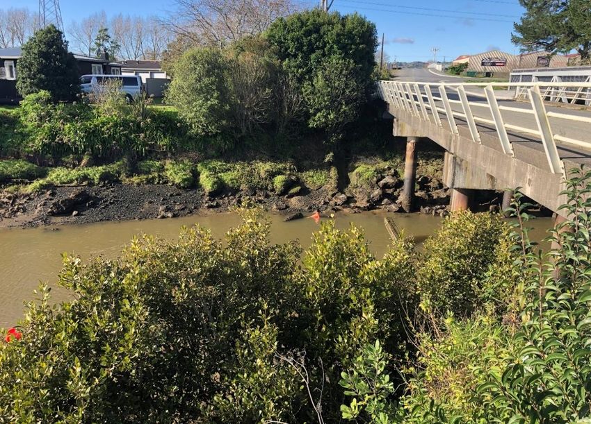
Figures
Figure 1-1 Approximate extents of P2B. Focus of this Report is Stage 1B1. Source: Aurecon NZ
 Ltd
Figure 1-2 Area of SH1 centred around Ngakoroa Stream leading into Drury Creek, and the
 Jesmond Bridge crossing forming part of the Project. Note: the dashed dark blue line
 is the CMA boundary from the AUP overlays. Background aerial map from 2017
 series. Source: Auckland Council GeoMaps.
Figure 2-1 Designated Significant Ecological Areas (SEAs) for Ngakoroa Stream in the AUP. The
 green crossed area marks the Terrestrial SEA (530b) upstream of the Jesmond
 Bridge and the blue crossed area marks the Marine–1 SEA (29b) in the lower
 Ngakoroa Stream and confluence with Drury Creek. The dark blue line delineates the
 CMA. Source: AUP GeoMaps layers and Section D9 (AUP).
Figure 3-1 Sub-structure of the existing traffic bridge and shared-use-path bridge (left) and
 western abutment in the relation to the sub-tidal channel at low tide on 19-June-2020
 (looking westward). Remnant bent pile from a previous bridge is shown in mid-
 channel. Credit: Rob Bell, NIWA
Figure 3-2 Overview plan of the proposed widened Jesmond Bridge and associated cycleway,
 footpaths (outer edges both sides) and pile/abutment groups (circles and dashed
 black lines) overlain for comparison on the existing bridge layout and pile groups (light
 grey lines). Scaling shown in chainage heading east from 180 m to 240 m. The
 elevation view of this revised design is shown in Figure 3-10. Source: Aurecon NZ
 Ltd, 22 Oct, 2020
Figure 3-3 Schematic of pile layout for the existing bridge (small light-grey circles) and proposed
 bridge (dark circles), with the latter skewed slightly eastward at 4° to the existing
 eastern pile group, with arrows indicative of flow direction (ebb tide). Dashed line
 shows the approximate edges of the sub-tidal channel at mean low water.
 Approximately to scale.
Figure 3-4 Rock and concrete rip-rap and abutments of the existing SUP and traffic bridges on
 the eastern bank (looking downstream – north). Credit: R Bell, NIWA.
Figure 3-5 Indicative re-sculpturing of the intertidal areas and adjacent banks proposed for
 declamation of the existing bridge abutments, backfill and rip-rap to reinstate the
 stream bed. Arrows show continuation of break lines in the intertidal profiles to
 connect in with the natural bank morphology north and south of the bridge. Dotted
 ellipse shows part of the western abutment embankment that will be removed. Also
 shows lateral end scour at end of rip-rap. Credit: R Bell, NIWA. 19-Jun-2020.
Figure 3-6 General layout of stormwater network and discharge outlets (blue arrows) for the
 Jesmond Bridge sub-catchment. Source: Drawing 506207-0450-DRG-WW-1452[A]
 (Aurecon NZ Ltd).
Figure 3-7 Existing scouring and slumping (lower left) from a broken/missing stormwater pipe
 (bottom right) exacerbated by concrete walls from an old swimming pool (upper left).
 Credit: R Bell, NIWA.
Figure 3-8 Locality layout plan of the existing and old pre-1968 bridge, stormwater pipes from the
 SH1 Bremner Road Overbridge and the location of the old swimming pool and
 concrete wall. Source: Drawing 6/6/865, Franklin County Council, January 1968).
Figure 3-9 Rise in storm-tide levels (m; NZVD-2016) for 2% AEP (top panel) and 1% AEP
 (bottom panel) at Jesmond Bridge for the four MfE coastal guidance SLR scenarios,
 adjusted to include vertical land movement for Auckland by 2120. For comparison, the
 bars show the range of soffit and deck levels for the existing bridge (dashed lines)
 and proposed longer bridge (heavy lines), where levels dip down from east to the
 west. Note: no freeboard allowance is included.
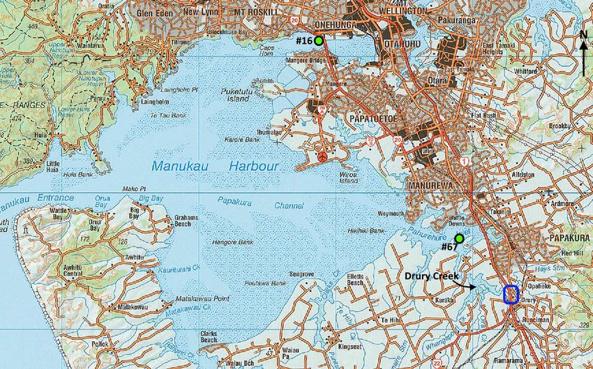
Figure 3-10 Elevation (looking downstream – north) of the revised design for two-span Jesmond
 Bridge and pile/abutment positions compared to the existing bridge and piles (dashed
 lines) and location and lowest envelope of overhead high-voltage lines (blue curve
 above Abutment A on the left side). The plan view of this revised design is shown in
 Figure 3-2. Source: Supplied by Aurecon NZ Ltd, 22 Oct 2020.

Tables
Table 2-1 Range of future storm-tide levels (m; NZVD-2016) at 2120 for different SLR scenarios
 from MfE (2017) coastal guidance for a normal base flow in Ngakoroa Stream and
 including a small trend of long-term landmass subsidence for the Auckland area (see
 section 3, Appendix A).
Table 3-1 Soffit and deck levels of the proposed 45 m long Jesmond Bridge that dips down
 towards the western abutment. Levels in NZVD-2016. Source: supplied by Aurecon
 NZ Ltd. – 11-September 2020.

Abbreviations
 Abbreviation Term

 AEE Assessment of Environmental Effects

 AS/NZS Australia/New Zealand Standard

 AT Auckland Transport

 AUP Auckland Unitary Plan

 AVD-46 Auckland Vertical Datum – 1946 (local survey datum)

 CMA Coastal Marine Area [as defined under section 2 of the RMA]

 CMCA Common marine and coastal area, used in the AUP. Has the same meaning as in
 the Marine and Coastal Area (Takutai Moana) Act 2011, and is similar to the CMA
 but excludes freehold land and Crown-owned reserves, conservation areas and
 national park in the CMA.

 CSI Coastal Storm Inundation control layer in the AUP (Chapter E36)

 Council Auckland Council

 ESCP Erosion Sediment Control Plan

 LINZ Land Information NZ
MHWS-10 Mean High Water Spring level which is only exceeded by 10% of all predicted high
 tides

NIMT North Island Main Trunk

NZCPS NZ Coastal Policy Statement (2010)

NZVD-2016 New Zealand Vertical Datum – 2016 (the national vertical datum)

OHL Overhead high-voltage lines

P2B SH1 Upgrades Project between Papakura to Bombay

RMA Resource Management Act 1991

SCI Southern Corridor Improvements

SEA Significant Ecological Area overlays in AUP for Terrestrial (including rivers, streams,
 wetlands) and Marine 1 and 2 areas (in the Regional Coastal Plan of the AUP)

SH State Highway

SH1 State Highway 1 Motorway, the Southern Motorway

SH22 State Highway 22 Motorway, Great South Road

SLR Sea-level rise

SUP Shared Use Path

Waka Kotahi Waka Kotahi NZ Transport Agency
1 INTRODUCTION

1.1 Papakura to Bombay Project Background
This Report supports the application lodged by Waka Kotahi New Zealand Transport Agency (Waka Kotahi) under
the Covid 19 Recovery (Fast Track Consenting) Act 2020 (FTA) for Stage 1B1 of the Papakura to Drury South
Project, a listed project under the FTA. For clarity and by way of summary we note that:
◼ The Papakura to Drury South Project was originally part of a larger project, called the Papakura to Bombay
 Project.
◼ Through the FTA, part of the Papakura to Bombay Project, being the Papakura to Drury South section, was
 included as a listed project under that Act.
◼ Waka Kotahi has broken the listed Papakura to Drury South project into further stages, with this application
 relating to Stage 1B1 only. Stage 1B1 is referred to as the Project throughout this document.
Further discussion of the different stages of the Papakura to Drury South Project is contained in the, Assessment of
Effects on the Environment (AEE), Design and Construction Report (Appendix C to the AEE) and legal submissions
supporting this application.

1.2 Stage 1B1 Papakura to Drury Interchange
As referred to in the AEE the geographic location of the Project is between the Papakura Interchange to south of the
Drury Interchange (Quarry Road), shown in Figure 1-1. The works will include infrastructure upgrades at the
Papakura Interchange, the Drury Interchange, and replacements of the SH1 Bremner Road Overbridge and Jesmond
Bridge (over Ngakoroa Stream). Additionally, it is also proposed to establish a shared use path (SUP) from the
Papakura Interchange to north of the Otūwairoa (Slippery Creek) Bridges, and from Bremner Road to south of the
Drury Interchange. A full description of the Project works is contained in the AEE and Design and Construction Report
(Appendix C to the AEE), supporting the application for resource consents and Notices of Requirement (NOR).

 WAKA KOTAHI NZ TRANSPORT AGENCY FILE 506207-0490-REP-NN-0059.DOCX | 9/06/2021 | REVISION 4 | PAGE 1
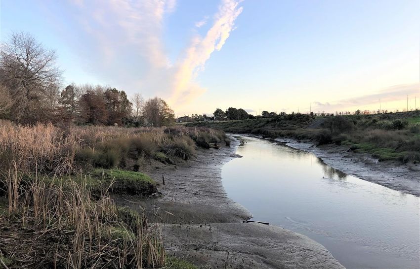
Figure 1-1 Approximate extents of P2B. Focus of this Report is Stage 1B1. Source: Aurecon NZ Ltd

1.3 Purpose of this Report
This report on coastal physical processes forms part of a suite of technical reports prepared for the Project. Its
purpose is to inform the AEE for:
◼ Resource consents for regional plan matters in the Auckland Unitary Plan (Operative in Part) 2016 (AUP).
Coastal processes are not a matter for consideration in a NOR and so do not need to be addressed in the context of
any NOR required for the Project. The purpose of this assessment is therefore restricted to an assessment of the
regional and regional-coastal plan matters in the AUP relating to coastal processes and climate-change effects in
respect of the Project.
In respect of coastal physical processes, the sole component of the Project that is relevant to this assessment is the
works associated with the Jesmond bridge on Bremner Road crossing over the tidal section of Ngakoroa Stream
(Figure 1-2).
This report assesses both the effects of the Project works on coastal physical processes and the effect of coastal
hazards and climate change on the Project works, and recommends mitigation, avoidance or management measures
to address any actual or potential adverse effects.
The purpose of this report is to:
 WAKA KOTAHI NZ TRANSPORT AGENCY FILE 506207-0490-REP-NN-0059.DOCX | 9/06/2021 | REVISION 4 | PAGE 2
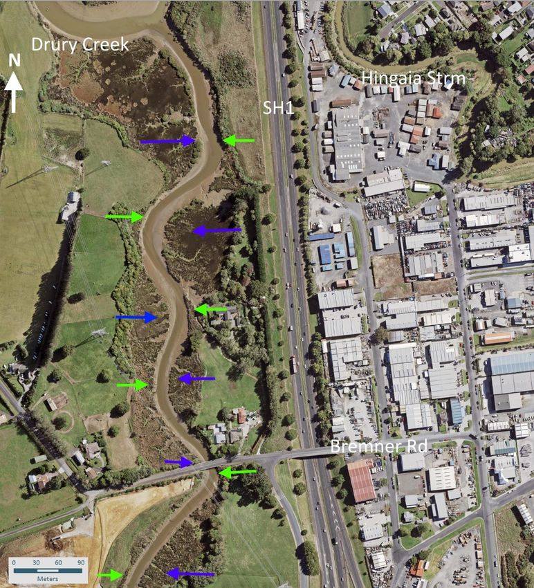
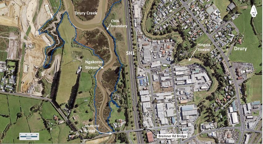
◼ Identify the existing and future coastal environment within the Project area;
◼ Assess the effects of construction and lifecycle operation of the Project works; and
◼ Recommend mitigation and management measures to address potential adverse effects of activities.
This report will provide recommendations determined appropriate to manage the effects on coastal processes, and
effects arising in relation to climate change and sea-level rise (SLR) over a 100-year lifecycle of the Project.
This report also refers to the technical appendices to the AEE and Appendix A of this report, which contains technical
supporting material prepared by the Author to supplement this assessment.
In assessing the effects on coastal processes, the main elements associated with the proposed works that are
assessed in this report are:
◼ During the construction phase, the effects of:
 − Adjacent land, stream-bed and water disturbing activities and potential suspended-sediment and
 construction-debris discharges on the coastal environments.

 − Physical interference of the flow from temporary staging structures.
◼ During the operation phase, the effects of:

 − The presence of permanent pile infrastructure in the coastal or stream environments.
 − Stormwater discharges on stream-beds and turbidity.

 − Flood/storm-tide hazards and sea-level rise on flood conveyance under the new bridge.

Figure 1-2 Area of SH1 centred around Ngakoroa Stream leading into Drury Creek, and the Jesmond Bridge crossing
 forming part of the Project. Note: the dashed dark blue line is the CMA boundary from the AUP overlays.
 Background aerial map from 2017 series. Source: Auckland Council GeoMaps.

 WAKA KOTAHI NZ TRANSPORT AGENCY FILE 506207-0490-REP-NN-0059.DOCX | 9/06/2021 | REVISION 4 | PAGE 3
1.4 Statutory Requirements

1.4.1 COVID-19 Recovery (Fast-track Consenting) Act 2020
The key relevant sections of the FTA in relation to land and coastal marine area disturbing activities and effects rising
from climate change are:
◼ Schedule 6, section 34(1) – “A panel may decline a consent application or cancel a notice of requirement for a
 listed project, but only on the following grounds:
 (a) that the panel considers that granting a resource consent or confirming or modifying a notice of
 requirement, with or without conditions, would be inconsistent with any national policy statement, including
 a New Zealand coastal policy statement.
 (b) that the panel considers that granting a resource consent or confirming or modifying a notice of
 requirement, with or without conditions, would be inconsistent with section 6 (Treaty of Waitangi).”
◼ Section 6 of the FTA requires the decision to be consistent with the principles of the Treaty of Waitangi and with
 any relevant Treaty settlements.

1.4.2 The New Zealand Coastal Policy Statement
The NZCPS is the operative national coastal policy statement under the RMA. The purpose of the NZCPS is to state
policies to achieve the purpose of the RMA in relation to the coastal environment of New Zealand. The relevant
objectives and policies of the NZCPS in relation to coastal physical processes and effects of climate change, from
the activities and operation of the Project works, are set out as follows:
Objective 1:
To safeguard the integrity, form, functioning and resilience of the coastal environment and sustain its ecosystems,
including marine and intertidal areas, estuaries, dunes and land, by:
◼ Maintaining or enhancing natural biological and physical processes in the coastal environment and recognising
 their dynamic, complex and interdependent nature; …..
Objective 3:
To take account of the principles of the Treaty of Waitangi, recognise the role of tangata whenua as kaitiaki and
provide for tangata whenua involvement in management of the coastal environment by:
◼ …
◼ recognising and protecting characteristics of the coastal environment that are of special value to tangata
 whenua.
Policy 1 (Extent and characteristics of the coastal environment):
(1) Recognise that the extent and characteristics of the coastal environment vary from region to region and locality
 to locality; and the issues that arise may have different effects in different localities.
(2) Recognise that the coastal environment includes:
 (a) the coastal marine area;
 ….
 (c) areas where coastal processes, influences or qualities are significant, including coastal lakes, lagoons, tidal
 estuaries, saltmarshes, coastal wetlands, and the margins of these;
 (d) areas at risk from coastal hazards;
 …

 WAKA KOTAHI NZ TRANSPORT AGENCY FILE 506207-0490-REP-NN-0059.DOCX | 9/06/2021 | REVISION 4 | PAGE 4
(h) inter-related coastal marine and terrestrial systems, including the intertidal zone; and
 (i) physical resources and built facilities, including infrastructure, that have modified the coastal environment.
Policy 3 (Precautionary approach):
(2) In particular, adopt a precautionary approach to use and management of coastal resources potentially
 vulnerable to effects from climate change, so that:
 (a) avoidable social and economic loss and harm to communities does not occur;
 (b) natural adjustments for coastal processes, natural defences, ecosystems, habitat and species are allowed to
 occur; and
 (c) the natural character, public access, amenity and other values of the coastal environment meet the needs of
 future generations.
Policy 6 (Activities in the coastal environment):
(1) In relation to the coastal environment:
 (a) recognise that the provision of infrastructure, the supply and transport of energy including the generation and
 transmission of electricity, and the extraction of minerals are activities important to the social, economic and
 cultural well-being of people and communities;
 (b) consider the rate at which built development and the associated public infrastructure should be enabled to
 provide for the reasonably foreseeable needs of population growth without compromising the other values of the
 coastal environment;
(2) Additionally, in relation to the coastal marine area:
 (e) promote the efficient use of occupied space, including by:
 (ii) requiring the removal of any abandoned or redundant structure that has no heritage, amenity or reuse
 value;
Policy 10 (Reclamation and de-reclamation):
(4) De-reclamation of redundant reclaimed land is encouraged where it would:
 (a) restore the natural character and resources of the coastal marine area; and
 (b) provide for more public open space.
Policy 22 (Sedimentation):
(1) Assess and monitor sedimentation levels and impacts on the coastal environment.
…
(4) Reduce sediment loadings in runoff and in stormwater systems through controls on land use activities.
Policy 23 (Discharge of contaminants):
(1) In managing discharges to water in the coastal environment, have particular regard to:
 (a) the sensitivity of the receiving environment;
 (b) the nature of the contaminants to be discharged, the particular concentration of contaminants needed to
 achieve the required water quality in the receiving environment, and the risks if that concentration of
 contaminants is exceeded; and
 (c) the capacity of the receiving environment to assimilate the contaminants;
 and:
 (d) avoid significant adverse effects on ecosystems and habitats after reasonable mixing;
 WAKA KOTAHI NZ TRANSPORT AGENCY FILE 506207-0490-REP-NN-0059.DOCX | 9/06/2021 | REVISION 4 | PAGE 5
(4) In managing discharges of stormwater take steps to avoid adverse effects of stormwater discharge to water in
the coastal environment, on a catchment by catchment basis, by:
 (b) reducing contaminant and sediment loadings in stormwater at source, through contaminant treatment and by
 controls on land use activities;
Policy 24 (Identification of coastal hazards):
(1) Identify areas in the coastal environment that are potentially affected by coastal hazards (including tsunami),
 giving priority to the identification of areas at high risk of being affected. Hazard risks, over at least 100 years,
 are to be assessed having regard to:
 (a) physical drivers and processes that cause coastal change including sea level rise;
 (b) short-term and long-term natural dynamic fluctuations of erosion and accretion;
 (c) geomorphological character;
 (d) the potential for inundation of the coastal environment, taking into account potential sources, inundation
 pathways and overland extent;
 (e) cumulative effects of sea level rise, storm surge and wave height under storm conditions;
 (f) influences that humans have had or are having on the coast;
 (g) the extent and permanence of built development; and
 (h) the effects of climate change on:
 (i) matters (a) to (g) above;
 (ii) storm frequency, intensity and surges; and
 (iii) coastal sediment dynamics;
 taking into account national guidance and the best available information on the likely effects of climate change
 on the region or district.
Policy 25 (Subdivision, use, and development in areas of coastal hazard risk):
In areas potentially affected by coastal hazards over at least the next 100 years:
 (a) avoid increasing the risk of social, environmental and economic harm from coastal hazards;
 …
 (d) encourage the location of infrastructure away from areas of hazard risk where practicable;

1.4.3 The National Policy Statement for Freshwater Management 2020
While largely focused on overall water quality and health of freshwater systems, the National Policy Statement for
Freshwater Management contains policies which relate to the coastal marine area including estuaries.
Relevant provisions in relation to coastal physical processes, from the activities and operation of the Stage 1B1
works, are:
Policy 7:
The loss of river extent and values is avoided to the extent practicable.
Clause 3.24, which requires regional councils to include the following policy (or words to the same effect) in its
regional plan(s):
The loss of river extent and values is avoided, unless the council is satisfied:
 (a) that there is a functional need for the activity in that location; and,
 WAKA KOTAHI NZ TRANSPORT AGENCY FILE 506207-0490-REP-NN-0059.DOCX | 9/06/2021 | REVISION 4 | PAGE 6
(b) the effects of the activity are managed by applying the effects management hierarchy.

 Under schedule 6, section 34(1) of the FTA, the principles of the Treaty of Waitangi are relevant to this
 application. However, the relevant iwi authorities for Stage 1B1 (as defined under the Act) have not
 identified any specific matters relevant to matters of coastal processes, climate change effects, or any
 Treaty principles relevant to coastal processes], (acknowledging however that there are Treaty principles
 relating to engagement which are relevant to the entire application and its effects, including coastal
 processes and climate change effects. This is addressed further in the AEE for Stage 1B1 regarding the
 engagement process undertaken with Mana Whenua).

1.4.4 Part II (RMA)
The most relevant assessment criteria from Part 2 of the RMA for coastal physical processes are:
◼ 6(h): the management of significant risks from natural hazards;
◼ 7(i): the effects of climate change.

 WAKA KOTAHI NZ TRANSPORT AGENCY FILE 506207-0490-REP-NN-0059.DOCX | 9/06/2021 | REVISION 4 | PAGE 7
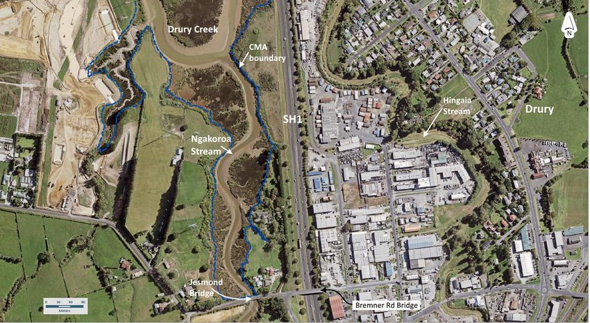
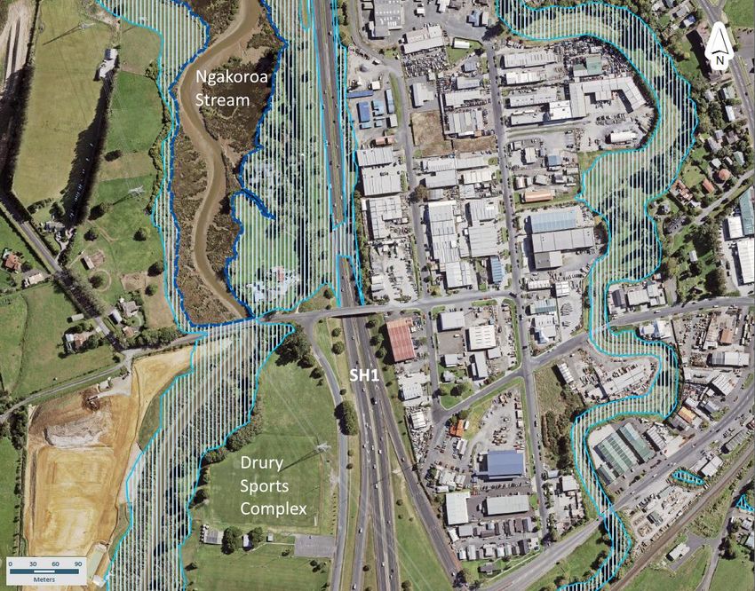
2 EXISTING AND FUTURE ENVIRONMENT
At the south-eastern extremity of Manukau Harbour, Drury Creek extends ~8.5 km to the south of Pahurehure Inlet
before bifurcating between Otūwairoa Creek (Slippery Creek) and Ngakoroa Stream adjacent to SH1. Due to the
large distance of ~45 km from Manukau Harbour Entrance (Tasman Sea) to Jesmond Bridge and the shallow water,
the tide exhibits a considerable time lag of 1 hour 25 minutes to 2 hours 20 minutes in the upper tributaries of Drury
Creek, relative to the tide change at the entrance.
The Coastal Marine Area (CMA) extends up the side arm Ngakoroa Stream of Drury Creek to the northern (seaward)
side of the existing Jesmond Bridge (over Ngakoroa Stream), coinciding with the Significant Ecological Area – Marine
1 overlay in the AUP (Figure 2-1). Further upstream from the northern side of the existing bridge,
freshwater/terrestrial policies and standards in the AUP apply, in particular those in the Significant Ecological Area –
Terrestrial overlay (Figure 2-1).
The existing AUP (artificially) divides Ngakoroa Stream between the CMA and “freshwater” at this point, when both
co-exist. However, the “freshwater” section of Ngakoroa Stream upstream of the existing bridge exhibits definite tidal
and salinity characteristics (see below). Therefore, this assessment assumes the tidal-stream south of the bridge is
also part of the coastal environment as defined in NZCPS1. In any case, over the 100-year operational life cycle of
the Jesmond Bridge (over Ngakoroa Stream), it is likely the functional CMA planning boundary will need to migrate
upstream with ongoing SLR.

1 As defined in Policy 1, NZ Coastal Policy Statement (2010) – NZCPS
 WAKA KOTAHI NZ TRANSPORT AGENCY FILE 506207-0490-REP-NN-0059.DOCX | 9/06/2021 | REVISION 4 | PAGE 8
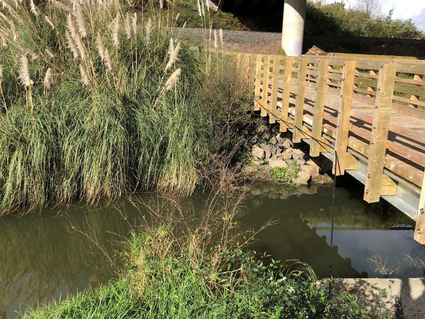
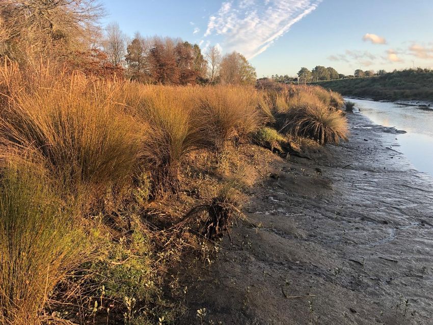
Figure 2-1 Designated Significant Ecological Areas (SEAs) for Ngakoroa Stream in the AUP. The green crossed area
 marks the Terrestrial SEA (530b) upstream of the Jesmond Bridge and the blue crossed area marks the Marine–1
 SEA (29b) in the lower Ngakoroa Stream and confluence with Drury Creek. The dark blue line delineates the CMA.
 Source: AUP GeoMaps layers and Section D9 (AUP)

The geomorphologic setting for the tidal section of Ngakoroa Stream comprises a deeply incised meandering channel
with relatively narrow intertidal areas and vegetated upper-tidal terraces backed by steep cliffs. A comparison of two
aerial photographs respectively from 1961 and 2017 (section 3, Appendix A) shows the flanking intertidal vegetation
has expanded slightly, but essentially the dendritic drainage patterns off the intertidal flats and general meander
morphology appears to have changed little over the intervening half century with the existing bridge in place. This
conclusion was also reached independently by Dahm (2016) for the Auranga Development west of the bridge, which
in his assessment there has been little historic morphological change overall.
Generally silty-sand sediments are present on the intertidal and upper-tidal areas (section 3, Appendix A), especially
adjacent to the existing bridge, but with a significant silt component in sediments on the upper intertidal area. The silt
component has the potential to generate substantial turbidity when disturbed while submerged.
On the eastern bank adjacent to the Drury Sports Complex grounds, just upstream of the existing bridge, there is
considerable scouring and slumping from progressive damage of the deteriorating stormwater pipe from the southern
side of the SH1 Bremner Road Overbridge, which is exacerbated by the dam effect of the remnant concrete walls
from an old swimming pool on the bankside of Ngakoroa Stream. The Project represents an opportunity to rectify this
legacy issue within the Project area at the same location as the new stormwater outlet.

 WAKA KOTAHI NZ TRANSPORT AGENCY FILE 506207-0490-REP-NN-0059.DOCX | 9/06/2021 | REVISION 4 | PAGE 9
The landward extent of the tidal influence in Ngakoroa Stream, expressed as the salinity incursion at high tide, ends
approximately 1.1 km upstream from the existing bridge, under the Great South Road Bridge over the NIMT railway
for base river flows (section 3, Appendix A). Tidal surface water level fluctuations (caused by freshwater backing up
behind the tidal water), will extend somewhat further upstream into the lowland freshwater section of the stream.
The existing bridge on Bremner Road over the Ngakoroa Stream (Jesmond Bridge), which was built in 1968–69, is
part of the existing environment to be considered when assessing effects, particularly the changes in effects from a
new traffic and shared-use pathway (SUP) bridges, in tandem with the removal of the existing bridge. The average
soffit2 and deck levels of the present bridge (ranges in brackets), which dips down to the westward end, are 3.7 m
[3.5–3.92] and 4.2 m [4.06–4.48] NZVD-20163 respectively, which will be compared with the new bridge design for
assessment of flood conveyance. The earliest aerial photograph (May 1942) shows a wooden bridge that was
replaced with the existing concrete Jesmond Bridge in 1968-69. Remnant piles from this previous bridge remain in
the channel, with some posing a water-recreational hazard and may be impeding flood flows by acting as a ‘snag’
for flood-debris.
The lag of the high water at Otūwairoa (Slippery Creek) Bridge (and similarly Jesmond Bridge) relative to Onehunga
Wharf tides varies considerably, ranging from a 40-minute lag for small neap tides up to 95 minutes for perigean-
spring (king) tides. Spring-tide high tides are lower by up to 0.15 m at Otūwairoa and Jesmond Bridges compared
with Onehunga Wharf, due to spring-tide dissipation up Drury Creek. From the Otūwairoa tide-gauge measurements,
a pragmatic Mean High Water Spring level, exceeded by only 10% of all high tides (MHWS-10), for the Jesmond
Bridge site is 1.72 m and the highest king tide (excluding weather and SLR) is 2.00 m (both to the NZVD-2016 datum).
The analysis (section 3, Appendix A) shows present-day storm-tide4 levels (e.g. 2% and 1% annual exceedance
probability levels of 2.59 and 2.68 m NZVD-2016), estimated for Onehunga Wharf (#16) in the Stephens et al. (2016)
report for Auckland Council, can be applied directly, without adjustments, to the design of the new Jesmond Bridge.
For the future, there is widening uncertainty towards the end of this century and beyond regarding what SLR will
transpire in response to global efforts to curb carbon emissions. I have used the 4 SLR scenarios out to 2120 (100-
year timeframe) in the MfE (2017) coastal hazards and climate change guidance, which is presently regarded as “..
national guidance and the best available information ..” under Policy 24 of the NZCPS. Table 2-1 lists the storm-tide
levels by 2120 for each SLR scenario applicable to the Jesmond Bridge, also incorporating a small vertical land
movement trend of subsidence in Auckland of -0.56 mm/year. This range of values for future storm-tide levels can
then be used for “stress-testing” the Jesmond Bridge design, as outlined in this assessment (next section) as
recommended by MfE (2017).
Given the Jesmond Bridge is sited towards the upper tidal reaches of Drury Creek (off Manukau Harbour) and in a
narrow, confined, channel, there is an interplay between river floods in the Ngakoroa Stream that coincide with coastal
conditions generating storm-tides. In this upper-reach location, either an extreme storm-tide or an extreme river flood
will be the dominating influence of extreme water levels (not both occurring concurrently). In such upper reaches of
tidal rivers, NIWA’s experience in modelling the river and storm-tide combinations generally show that the storm-
surge influence is invariably “washed out” by moderate to high river floods (e.g. McBride et al., 2017).

2 Defined as the underside level of a bridge, which determines the upper surface of the waterway under the bridge.
3 Levels are generally provided in terms of NZ Vertical Datum-2016 (NZVD-2016).
4 Storm tide = high tide + storm surge (low pressure & wind set-up) + month-to-month variation in mean sea level.

 WAKA KOTAHI NZ TRANSPORT AGENCY FILE 506207-0490-REP-NN-0059.DOCX | 9/06/2021 | REVISION 4 | PAGE 10
Table 2-1 Range of future storm-tide levels (m; NZVD-2016) at 2120 for different SLR scenarios from MfE (2017)
 coastal guidance for a normal base flow in Ngakoroa Stream and including a small trend of long-term
 landmass subsidence for the Auckland area (see section 3, Appendix A).

 Storm-tide levels [2120] 2% AEP (ARI 50 yrs) [m] 1% AEP (ARI 100 yrs) [m]

 RCP2.6 M SLR scenario 3.20 3.29

 RCP4.5 M SLR scenario 3.32 3.41

 RCP8.5 M SLR scenario 3.71 3.80

 RCP8.5 H+ SLR scenario 4.01 4.10

 WAKA KOTAHI NZ TRANSPORT AGENCY FILE 506207-0490-REP-NN-0059.DOCX | 9/06/2021 | REVISION 4 | PAGE 11
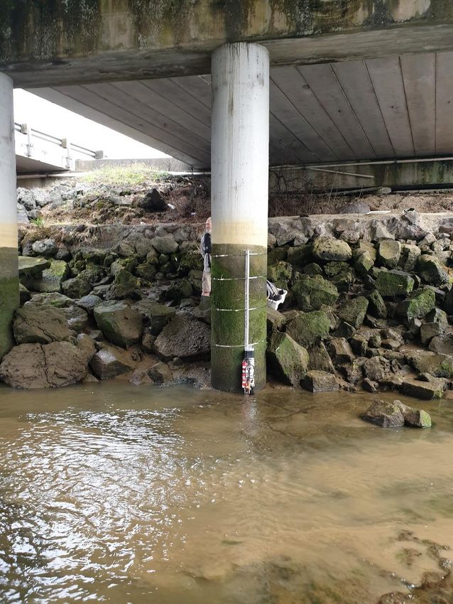
3 ASSESSMENT OF EFFECTS
The following sections detail the assessment of temporary and permanent Project works, associated with the
Jesmond Bridge, on coastal physical processes in the coastal environment of Ngakoroa Stream, and also the effect
of climate change and coastal hazards on the operational lifecycle utility of the new bridge and associated permanent
works, to avoid increasing the risk from climate change and SLR.

3.1 Assessment scope and criteria
Both temporary effects during construction/demolition and declamation and those long-term effects that may accrue
over the 100-year operational life of the Project are considered separately in this section.
In respect of coastal physical processes, the sole component of the Project that is relevant to this assessment is the
works associated with the new Jesmond Bridge (including the cycleway and footpaths) over the tidal section of
Ngakoroa Stream. It includes demolition of the existing bridges (including piers/piles) and declamation of the existing
abutments (Figure 3-1).
Coastal physical processes broadly includes tidal flows, sediment transport and stream-bed scour, geomorphology
change, coastal hazards and climate change effects, particularly SLR.

Figure 3-1 Sub-structure of the existing traffic bridge and shared-use-path bridge (left) and western abutment in the
 relation to the sub-tidal channel at low tide on 19-June-2020 (looking westward). Remnant bent pile from a
 previous bridge is shown in mid-channel. Credit: Rob Bell, NIWA

This assessment of effects of the Jesmond Bridge over the operational lifecycle of the Project on coastal physical
processes, describes and assesses the longer-term effects that potentially could affect these processes and the
effects of short-term construction activities.

 WAKA KOTAHI NZ TRANSPORT AGENCY FILE 506207-0490-REP-NN-0059.DOCX | 9/06/2021 | REVISION 4 | PAGE 12
A key requirement for this coastal-processes assessment is the planning/life-cycle timeframe. Effects over the
operational life-cycle of 100 years (i.e. by 2120) were considered, which is also a requirement of the NZCPS (Policies
24–25, 27) to assess physical effects on the coastal environment and the effects of climate change on coastal
hazards over “at least 100 years”. Extended projections of SLR and storm-tide levels out to 2150 are also provided
for context (contained in section 3 of Appendix A).
Key statutory criteria used for assessing coastal physical processes are (using underlining emphases):
◼ The Covid-19 Recovery (Fast-track Consenting) Act 2020, which directs to Part II matters in the RMA and
 adhering to the principles associated with the Treaty of Waitangi. In assessing coastal physical processes,
 natural coastal hazards and climate change effects, section 6(h), 7(f, i), as outlined in Section 1.4, are most
 relevant for this assessment;
◼ NZ Coastal Policy Statement (2010) matters – specifically the following criteria to assess against (underlining for
 relevant aspects):
 − Objective 1— Safeguard the integrity, form, functioning and resilience of the coastal environment …. by
 maintaining or enhancing natural biological and physical processes in the coastal environment and
 recognising their dynamic, complex and interdependent nature …;

 − Policy 3 (Precautionary approach)— In particular, adopt a precautionary approach to use and management
 of coastal resources potentially vulnerable to effects from climate change, so that: … (b) natural adjustments
 for coastal processes, natural defences, ecosystems, habitat and species are allowed to occur;

 − Policy 6 (Activities in the coastal environment) — In relation to the CMA: (e) promote the efficient use of
 occupied space, including by: (ii) requiring the removal of any abandoned or redundant structure that has no
 heritage, amenity or reuse value;
 − Policy 10 (Reclamation and de-reclamation) — Sub-section (4) states that de-reclamation of redundant
 reclaimed land is encouraged where it would: (a) restore the natural character and resources of the coastal
 marine area;

 − Policy 22 (Sedimentation) — Require that … development will not result in a significant increase in
 sedimentation in the CMA …;

 − Policy 23 (Discharge of contaminants) — Sub-section (1) applies to the discharge of contaminants (which
 generally includes fine silts and muds) and the need to avoid significant adverse effects after allowing for
 reasonable mixing (using the smallest mixing zone necessary …);

 − Policies 24 and 25 (Coastal hazards, climate change and development in areas of coastal risk) — Requires
 assessment of the effect of coastal hazards and climate change over at least a 100-year timeframe, taking
 into account national guidance and the best available information. Policy 25 requires avoidance of increasing
 the risk of social, environmental and economic harm from coastal hazards;
◼ The National Policy Statement for Freshwater Management 2020 (NPS:FM) also contains values to be
 considered in freshwater bodies – the most relevant for physical processes in the coastal environment, are in
 relation to:
 − The natural location of a water body and course of a river, to ensure the loss of river extent is avoided (Policy
 7 and 3.24 of NPS:FM); and

 − Management of fine sediment (similar to Policy 22, NZCPS).
In assessing effects physical effects on the coastal environment, I also aligned the assessment to relevant AUP
policies, and standards (rules) related to the SEA-Terrestrial overlay for streams and wetlands in Chapter E3 of the
AUP, which mostly also apply to the SEA-Marine 1 overlay (Chapter F: Regional Coastal Plan), with the respective
designated SEA areas shown either side of the Jesmond Bridge in Figure 2-1.

 WAKA KOTAHI NZ TRANSPORT AGENCY FILE 506207-0490-REP-NN-0059.DOCX | 9/06/2021 | REVISION 4 | PAGE 13
There are no quantitative environmental assessment criteria for assessing and determining the degree of effects 5
(e.g. negligible, moderate, significant) on hydrodynamic and sedimentation processes or estuarine geomorphology.
This assessment therefore relies on a combination of general and statutory criteria, AUP provisions and national
guidance, built on site-specific observations and expert assessment and peer review (see methodology in section 2,
Appendix A).
In assessing the effects on coastal physical processes, I used the following five effects categories (relative to the
existing coastal environment) in determining consistency with national policy instruments and the Part II matters of
the RMA:6
◼ Positive (beneficial) outcome.
◼ Neutral (no change envisaged).
◼ Negligible effect – would be difficult to discern or monitor such an effect over and above natural variability in the
 existing and future environment.
◼ Moderate effect – between a negligible and significant effect, which can include future potential effects from
 natural hazards compounded by climate change and SLR, or cumulative effects, where some mitigation would
 be required in the design, remediation, monitoring or otherwise, to minimise or avoid the effect.
◼ Significant (adverse) effect – where substantial mitigation is required in the design, remedial works or otherwise
 to minimise, offset or avoid adverse component of the effect.
The overview of the proposed design for the Jesmond Bridge is shown in Figure 3-2 and described in more detail in
the Design and Construction report in Appendix C of the AEE. It comprises two spans – a short 15m span on the
eastern side (to ensure bridge piles avoid the main tidal channel) and a longer 28-35m length through to the slanted
western abutment (to reduce construction constraints under the long-hung overhead transmission lines).
The landward boundary of the CMA presently is the northern edge of the existing bridge. As the proposed 16m wide
bridge is nearly twice the width of the existing bridge (due partly to the separated footpath and cycleway), it
encroaches further north into and above the CMA, while to the south would be a similar extent to the existing shared-
use path bridge (cross hatched area in Figure 3-2). Stormwater outlets will be positioned on both east and west
banks on the southern side of the new bridge in the tidal-stream section.
Note: As the new bridge is longer, with abutments further landward on both sides, no reclamations or impoundments,
such as causeways or sheet-piling dams are required in the CMA or the tidal-stream section for either the construction
phase or the operational life-cycle of the Project.

5 Meaning of effect is defined in s3 RMA
6 Effect is defined in s. 3 of RMA
 WAKA KOTAHI NZ TRANSPORT AGENCY FILE 506207-0490-REP-NN-0059.DOCX | 9/06/2021 | REVISION 4 | PAGE 14
Figure 3-2 Overview plan of the proposed widened Jesmond Bridge and associated cycleway, footpaths (outer edges
 both sides) and pile/abutment groups (circles and dashed black lines) overlain for comparison on the
 existing bridge layout and pile groups (light grey lines). Scaling shown in chainage heading east from 180 m to
 240 m. The elevation view of this revised design is shown in Figure 3-10. Source: Aurecon NZ Ltd, 22 Oct, 2020

In assessing the effects on coastal physical processes, the main elements associated with the proposed works for
the Jesmond Bridge assessed were:
◼ During the construction phase, the effects of:

 − Temporary staging platforms supported on piles in the CMA or coastal environment (including the tidal-
 stream section upstream of the bridge crossing).

 − Temporary occupation of the coastal environment.

 − Disturbances of soft fine sediments within the tidal-creek channel and adjacent banks and intertidal areas
 e.g. pile driving/boring for temporary staging and permanent pile groups.

 − De-construction of the existing bridge and SUP bridge piles including the management of construction
 debris.

 − Declamation of the eastern and western abutments and associated embankments of the existing bridge.
◼ Effects on coastal physical processes during the operational life-cycle, and specifically the effects of:

 − New Jesmond Bridge, particularly support structures, such as piers/piles and the soffit elevations in relation
 for flood conveyance.

 − The new adjoining road and cycleway/footpath abutments and associated rip-rap protection for the bridge
 sub-structure.

 − Any additional permanent occupation of the coastal environment (compared with the existing environment).
 − Rehabilitating stream banks after declamation of the existing bridge abutments.
 − Encroachment by elements of the new Jesmond Bridge, which carries the potential for morphological change
 in the tidal-stream regime.

 − Stormwater outlets on the southern side of the new bridge on Ngakoroa Stream.
◼ Although not an effect of Stage 1B1, I also considered the potential for coastal flooding to be exacerbated by
 climate change as sea level rises, in relation to the elevations of the new bridge/abutments (deck and soffit
 levels).

 WAKA KOTAHI NZ TRANSPORT AGENCY FILE 506207-0490-REP-NN-0059.DOCX | 9/06/2021 | REVISION 4 | PAGE 15
3.2 Effects of temporary construction, demolition and declamation of the
 Jesmond Bridge on coastal physical processes
This assessment of temporary construction effects of the Project (Jesmond Bridge) on coastal physical processes is
framed around specific types of effects and describing and assessing the construction activities (see Design and
Construction Report, Appendix C of the AEE report) that potentially could affect coastal physical processes.
Essential erosion and sediment control measures, to control discharges and stream-bed disturbances as much as
possible at the source, are contained in the Construction Water Erosion Sediment Control (CWESC) Assessment
(contained in Appendix I of the AEE).
My assessment of the temporary effects at different stages over the demolition/declamation and construction phases
(approximately 27 months) focuses on three categories of effects:
 a) Functioning of geomorphic and hydrodynamic processes;
 b) Sediment disturbances in the coastal environment;
 c) Temporary discharges (including debris from demolition processes).

3.2.1 Functioning of geomorphic and hydrodynamic processes
Temporary staging structures to support working platforms would be required for both demolition of the existing
piers/piles and the construction of the new bridge pier and supporting piles (if the existing bridge has insufficient
bearing capacity for the pile boring/driving plant). The main-access and temporary staging area would be launched
perpendicular to the stream flow from the south-eastern bank and supported on steel piles in the stream bed. During
demolition of the existing bridge, additional staging platforms will extend at an angle towards the two existing-bridge
pile groups and pier heads (refer to the Design and Construction Report, Appendix C of the AEE). The steel piles for
staging platforms would have a 0.7 m diameter, which is similar to the existing bridge piles (0.61 m).
Temporary scaffolding or staging would also be erected around the piers and abutments of the existing bridge to
allow piecemeal demolition from top down with small machinery (west side under high voltage lines) or with larger
machinery on the east side.
Steel piles supporting these platforms will temporarily occupy the streambed or seabed (if in the CMA) and the
platforms would temporarily occupy the airspace above the tidal stream. In this assessment I have assumed the
temporary piles sets are aligned with the stream flow to minimise flow impedance and debris trapping during any
flood or storm-tide events.
There is potential for small-scale local scour around these temporary steel piles, as they are positioned within the
main sub-tidal channel and will be situated around the existing pier cross-heads and piles (Figure 3-1), noting the
piles within the main channel would be driven deeper to mitigate the effects of local scour on the integrity of the
temporary structures. Once the temporary steel piles are removed after construction, any remnant local scour holes
in the streambed will be covered over by sediment transport and sedimentation induced by higher spring tide flows
and/or river floods. Therefore, the effect of staging-platform piles on causing local scour will be a temporary negligible
effect.
The piles supporting the staging platforms associated with pier construction or demolition will cause some temporary
impedance to the channel flow at all tidal elevations and for any river floods that eventuate during construction. This
would result in a reduction in the overall net flow area when considering the cumulative flow blockage of the temporary
staging piles, together with the permanent column piles of the new bridge pier as they are successively built as well
as the existing piles being de-constructed (depending on final construction sequencing). Successive sequencing of
the occupation of the streambed by various temporary piles or scaffolding through an Erosion and Sediment Control
Plan would be needed to minimise flow impedance at any one time during the demolition/construction phases.
Temporary staging positioned at higher bank elevations around the east and west abutments (existing and new)
would be unlikely to affect the flow in Ngakoroa Stream, unless a large flood eventuated (which could be alleviated
by emergency preparations following an impending flood forecast).
 WAKA KOTAHI NZ TRANSPORT AGENCY FILE 506207-0490-REP-NN-0059.DOCX | 9/06/2021 | REVISION 4 | PAGE 16
The mitigation measures that should be factored into in the construction methodology to minimise the flow impedance
are:
◼ To avoid, where practicable, placing piles in the deepest part of the channel, which is adjacent to the western
 side of the eastern pile group of the existing bridge (nearest pile group in Figure 3-1) and the western side of
 the new bridge piles (Figure 3-10), where the strongest tidal and flood flows occur; and
◼ Aligning temporary pile groups and the staging platforms approximately with the stream flow direction, which
 means they will need to be placed at approximately the same angle as the eastern pile group of the existing
 bridge.
These mitigation measures will reduce the overall impedance of any tidal and/or flood flows during demolition and
construction and also reduce the potential local scouring effects as far as practical. With such measures in place, the
temporary-staging piles would present a small, temporary, reduction in flow cross-section below the MHWS-10 level,
assuming close alignment with the local stream flow.

3.2.1.1 Assessment summary
The effect of the temporary-staging piles on flow impedance and geomorphic processes would be short-lived and
negligible overall, assuming minimal staging piles in the deeper part of the channel and pile groups are aligned with
the local stream flow direction.

3.2.2 Sediment disturbances in the coastal environment
Potentially, the key environmental risks to coastal physical processes (and aquatic habitats) are those activities that
can produce sediment disturbances within the coastal environment and subsequent runoff to the CMA or the
upstream tidal stream during:
◼ Removal of the existing abutments.
◼ Any vegetation removal that may be required.
◼ Removal and cutting, to just below the seabed or streambed, of piles supporting the existing bridge and all other
 remnant piles from previous bridges.
◼ Driving and extraction of temporary staging steel piles.
◼ Construction of the new abutments and back filling.
◼ Removal of existing rip-rap from the intertidal areas under the existing bridges (Figure 3-1 and Figure 3-4) and
 placement of new rip-rap higher up to protect the new abutments.
◼ Pile driving or boring into the seabed or streambed for the new bridge piles.
Fortunately, the potential risk of sediment disturbances leading to runoff, causing elevated turbidity downstream
(depending on the tidal flow direction), can be largely mitigated at source (refer to the CWESC Assessment contained
in Appendix I of the AEE and section 1 in Appendix A).
However, some release of fine-sediment is unavoidable as, for example, fine cohesive material adheres to rip-rap
and piles and unavoidably slumps off into the stream onto the intertidal areas. Similarly, the slow reworking of
newly exposed intertidal muds, where the existing rip-rap has been removed, will mobilise any loose stream-bed
sediments until the uncovered area reaches equilibrium with the tidal flows.
Disturbances of the seabed within the CMA or stream bed channel will occur during the following works:
◼ Driving of piles to support the temporary staging, foundation works for the permanent column piles, boring or
 driving the new bridge piles.
◼ Extraction of piles and any associated sheet-piling to remove the temporary staging.
◼ Cutting the eight piles of the existing bridge and those remnant piles from previous bridges.
 WAKA KOTAHI NZ TRANSPORT AGENCY FILE 506207-0490-REP-NN-0059.DOCX | 9/06/2021 | REVISION 4 | PAGE 17
These potentially adverse activities in the stream, while localised in extent and short-lived, will still require work
practices and erosion/sediment control measures (see the CWESC Assessment contained in Appendix I of the AEE
and Appendix A) that minimise seabed or stream bed disturbance and hence release of suspended-sediments to
the receiving waters, thereby minimising the effects on existing water clarity from increased turbidity.
The disturbance of the seabed on installation and subsequent removal of the temporary staging and steel piles is
expected to be minimal (including turbidity, after allowing for reasonable mixing) and full restoration of the seabed
and streambed from the disturbances is anticipated within weeks (especially on spring-tides) or higher river flows,
due to both the limited area of disturbance and the moderate peak tidal flows that are present at this location.
The existing bridge piles would be very difficult, if not impossible, to completely remove without causing significant
adverse effects, as this would require pulling them out of the seabed, causing substantial disturbance of the substrate
where they have been in place for over 50 years. During demolition of the existing bridge, piles would be cut as close
to or just underneath the bed level as possible. If the cutting procedure is undertaken by clamping the pile above and
below the cut point, avoiding disturbance of the seabed by keeping the bottom section of the clamp just at the bed
level will mean the cut level will be slightly above the existing bed. However, it is probable that local scour holes exist
around these long-standing piles, so subsequent sedimentation would tend to eventually cover the remnant pile
stumps protruding above the bed level (but which maybe temporarily re-exposed during extreme river floods posing
a negligible effect on the geomorphology of Ngakoroa Stream).

3.2.2.1 Assessment summary
Potentially, pile or sheet-pile driving or extraction and rip-rap removal or placement activities could cause localised
release of suspended-sediments to the receiving waters from riverbed disturbances. Work practices and
erosion/sediment control measures (detailed within an Erosion and Sediment Control Plan) that minimise seabed or
streambed disturbance, would therefore minimise the short-lived effects on existing water clarity from increased
turbidity to be negligible.
For removal of the piles from the existing bridge and remnant piles from previous bridges, if piles are cut at or just
above the existing seabed or streambed, I have assessed these temporary effects on coastal processes as being
negligible.

3.2.3 Discharges to the coastal environment
Environmental effects on coastal physical processes (and aquatic habitats – refer to the Ecological Assessment
contained in Appendix P of the AEE) can arise from intermittent discharges or runoff (considered in the previous sub-
section) to the CMA or the upstream tidal stream of Ngakoroa Stream. Intermittent discharges would arise from:
◼ Permanent and temporary piles – for any dewatering required.
◼ Abutment works –from drainage flow paths towards receiving water environments from stormwater and
 dewatering.
◼ Temporary staging platforms – runoff from staging or scaffolding decks.
◼ De-construction – discharges from concrete cutting processes, dust, concrete/steel debris.
In assessing temporary discharges that directly or indirectly pose a risk to the Ngakoroa Stream, I have assumed the
use of best practicable options for erosion and sediment control and management and treatment (ideally off-site) of
intermittent discharges at source (refer to CWESC Assessment contained in Appendix I of the AEE and the Design
and Construction Report contained in Appendix C of the AEE). This approach diminishes the reliance on reasonable
mixing in the receiving water environment to reduce the effects from elevated turbidity, which is consistent with Policy
23(1) of the NZCPS.
Bridge de-construction is a specialist area of expertise and there are a number of methodologies that could be
employed. The contractor will develop their own preferred methodology and mitigation measures (e.g., dust and
debris controls) for removal of the bridge superstructure and piers/piles. However, it is envisaged (refer to the Design
 WAKA KOTAHI NZ TRANSPORT AGENCY FILE 506207-0490-REP-NN-0059.DOCX | 9/06/2021 | REVISION 4 | PAGE 18
You can also read