Frequently Asked Questions on Tropical Cyclones - Meteorological Centre at GANGTOK
←
→
Page content transcription
If your browser does not render page correctly, please read the page content below
Frequently Asked Questions
on
Tropical Cyclones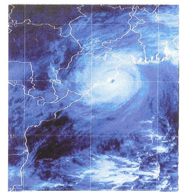
Frequently Asked Questions on Tropical Cyclones

1. What is a tropical cyclone?

       A tropical cyclone (TC) is a rotational low-pressure system in tropics when the
central pressure falls by 5 to 6 hPa from the surrounding and maximum sustained
wind speed reaches 34 knots (about 62 kmph). It is a vast violent whirl of 150 to 800
km, spiraling around a centre and progressing along the surface of the sea at a rate
of 300 to 500 km a day.

        The word cyclone has been derived from Greek word ‘cyclos’ which means
‘coiling of a snake’. The word cyclone was coined by Heary Piddington who worked
as a Rapporteur in Kolkata during British rule. The terms "hurricane" and "typhoon"
are region specific names for a strong "tropical cyclone". Tropical cyclones are called
“Hurricanes” over the Atlantic Ocean and “Typhoons” over the Pacific Ocean.

2. Why do ‘tropical cyclones' winds rotate counter-clockwise (clockwise) in the
Northern (Southern) Hemisphere?

         The reason is that the earth's rotation sets up an apparent force (called the
Coriolis force) that pulls the winds to the right in the Northern Hemisphere (and to the
left in the Southern Hemisphere). So, when a low pressure starts to form over north
of the equator, the surface winds will flow inward trying to fill in the low and will be
deflected to the right and a counter-clockwise rotation will be initiated. The opposite
(a deflection to the left and a clockwise rotation) will occur south of the equator.

       This Coriolis force is too tiny to effect rotation in, for example, water that is
going down the drains of sinks and toilets. The rotation in those will be determined
by the geometry of the container and the original motion of the water. Thus, one can
find both clockwise and counter-clockwise flowing drains no matter what hemisphere
you are located. If you don't believe this, test it out for yourself.

3. What does "maximum sustained wind" mean? How does it relate to gusts in
tropical cyclones?

       India Meteorological Department (IMD) uses a 3 minutes averaging for the
sustained wind. The maximum sustained wind mentioned in the bulletins used by
IMD is the highest 3 minutes surface wind occurring within the circulation of the
                                                                                      2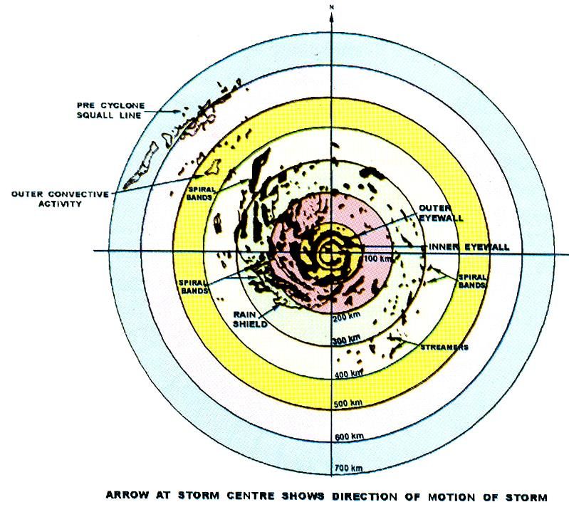
system. These surface winds are observed (or, more often, estimated) at the
standard meteorological height of 10 m (33 ft) in an unobstructed exposure (i.e., not
blocked by buildings or trees).
The National Hurricane Centre uses a 1 minute averaging time for reporting
the sustained. Some countries also use 10 minutes averaging time for this purpose.
While, one can utilize a simple ratio to convert from peak 10 minute wind to peak 1
minute wind or 3 minute wind, such systematic differences to make interbasin
comparison of tropical cyclones around the world is problematic. However there is
no significant difference between the maximum sustained winds reported in different
basis with different averaging method.
3. What is the energy potential of a Tropical Cyclone?
Tropical Cyclone can be compared to a heat engine. The energy input is from
warm water and humid air over tropical oceans. Release of heat is through
condensation of water vapour to water droplets/rain. Only a small percentage (3%) of
this released energy is converted into Kinetic energy to maintain cyclone circulation
(windfield). A mature cyclone releases energy equivalent to that of 100 hydrogen
bombs.
4. How are low pressure system classified in India? What are the differences
between low, depression and cyclone?
The low-pressure systems over Indian region are classified based on the
maximum sustained winds speed associated with the system and the pressure
deficit/ number of closed isobars associated with the system. The pressure criteria is
used when the system is over land and wind criteria is used, when the system is
over the sea. The system is called as low if there is one closed isobar in the interval
of 2 hPa. It is called depression, if there are two closed isobars, a deep depression, if
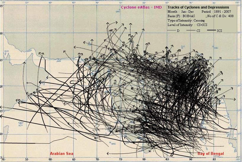
there are three closed isobars and cyclonic storm if there are four or more closed
isobars. The detailed classification based on wind criteria are given in the Table
below. Considering wind criteria, the system with wind speed of 17-27 knots is called
as depression and the low pressure system with maximum sustained 3 minutes
surface winds between 28-33 knots is called a deep depression. The system with
maximum sustained 3 minutes surface winds of 34 knots or more is called as
cyclonic storm.
3
System                    Pressure deficient    Associated wind speed
                                hPa w.r.t T No.       Knots (Kmph)
Low pressure area                     1.0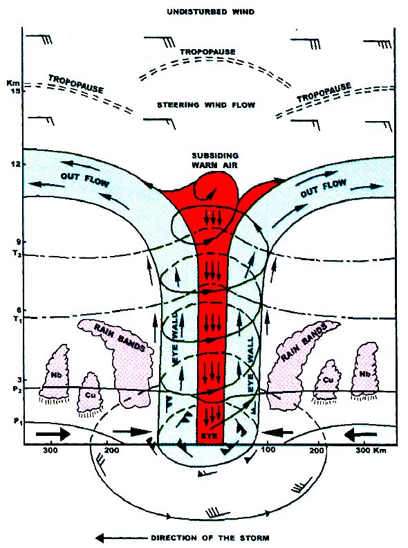
Ocean. Similarly, “Super-typhoon" is a term utilized by the U.S. Joint Typhoon
Warning Centre for typhoons that reach maximum sustained 1 minute surface winds
of at least 130 knots (65 m/s). This is the equivalent of a strong Saffir-Simpson
category 4 or category 5 hurricane in the Atlantic basin or a category 5 severe
tropical cyclone in the Australian basin.

8. What is landfall of a cyclone?
         Landfall is the event of a tropical cyclone coming onto land after being over
water.
       A tropical cyclone is classified as making landfall when the center of the storm
moves cross the coast; in strong tropical cyclones this is when the eye moves over
land. This is where most of the damage occurs within a mature tropical cyclone as
most of the damaging aspects of these systems are concentrated near the eyewall.
Such effects include the peaking of the storm surge, the core of strong winds comes
on shore, and heavy flooding rains. These coupled with high surf can cause major
beach erson. When a tropical cyclone makes landfall, the eye closes in upon itself
due to the weakening process, which causes surf to decrease. Maximum sustained
wind will naturally decrease as the cyclone moved inland due to frictional differences
between water and land with the free atmosphere.
       A "landfall" should not be confused with a direct hit, as a direct hit is where the
core of high winds (or eyewall) comes onshore but the center of the storm may stay
offshore. The effects of this are similar to a landfall, as this term is used when the
radius of maximum wind within a tropical cyclone moves ashore. These effects are;
high surf, heavy rains that may cause flooding, water build up along the coast with
minor storm surge, coastal beach erosion, high winds, and possibly severe weather.
9. What is radius of maximimun wind of a Tropical cyclone?
       The radius of maximum wind (RMW) of a tropical cyclone is defined to be the
distance between the center of the cyclone and its band of strongest winds. It is
considered an important parameter in atmospheric dynamics and tropical cyclone
forecasting.
10. How does the radius of maximum wind determined?
Aircraft
         The RMW is traditionally measured by reconnaissance aircraft in the Atlantic
basin. It can also be determined on weather map as the distance between the
cyclone center and the system's greatest pressure gradient.
Satellite
         The distance between the coldest cloud top temperature and the warmest

                                                                                        5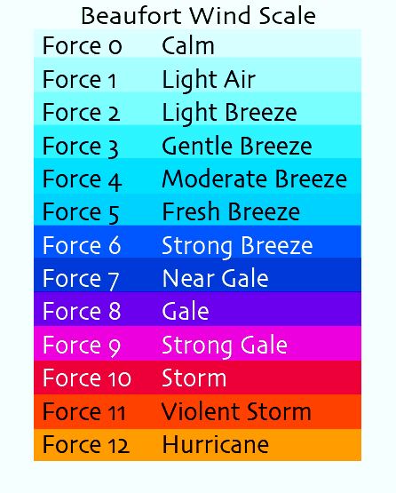
temperature within the eye, in infrared satellite imagery, is one method of
determining RMW. The reason why this method has merit is that the strongest winds
within tropical cyclone tend to be located under the deepest convection, which is
seen on satellite imagery as the coldest cloud tops
11. What does the RMW help to determine?
      The radius of maximum wind helps determine the direct strikes of tropical
cyclones. Tropical cyclones are considered to have made a direct strike to a
landmass when a tropical cyclone passes close enough to a landmass that areas
inside the radius of maximum wind are experienced on land.
       The highest storm surge is normally coincident with the radius of maximum
wind. Because the strongest winds within a tropical cyclone lie at the RMW, this is
the region of a tropical cyclone which generates the dominant waves near the storm,
and ultimately ocean swell away from the cyclone.
12. What is radius of maximum reflectivity?

        The radial distance from the Tropical cyclone centre to the point of maximum
reflectivity is known as the radius of maximum reflectivity.

13. Where do Tropical Cyclones form?

      The tropical cyclones form over ocean basins in lower latitudes of all oceans
except south Atlantic and southeast Pacific. The tropical cyclones develop over the
warm waters of the Bay of Bengal and the Arabian Sea. The favourable ocean
basins for development of cyclonic storms are shown in the figure below.

TC breeding grounds are located over certain ocean basins. Arrows indicate average

                                                                                      6
trajectories over different basins
14. What is the size of a tropical cyclone over the north Indian Ocean?
The size of a Tropical Cyclone over Indian seas varies from 50-100 km radius
to 2000 km with an average of 300 –600 km.
15. What is the structure of a Tropical Cyclone?
A fully developed tropical cyclone has a central cloud free region of calm
winds, known as the “eye” of the cyclone with diameter varying from 10 to 50 km.
Surrounding the eye is the “wall cloud region” characterised by very strong winds
and torrential rains, which has the width of about 10 to 150 km. The winds over this
region rotate around the centre and resemble the “coils of a snake”. Wind speed fall
off gradually away from this core region, which terminate over areas of weaker winds
with overcast skies and occasional squall .There may be one or more spiral branch
in a cyclone where higher rainfall occurs. The vertical extent of the cyclone is about
15 km. The INSAT imagery of Orissa Super cyclone on 29 th October, 1999 is shown
in the figure below.
716. What is a "CDO"?
"CDO" is an acronym that stands for "central dense overcast". This is the
cirrus cloud shield that results from the thunderstorms in the eyewall of a tropical
cyclone and its rainbands. Before the tropical cyclone reaches very severe cyclonic
storm (64 knots), typically the CDO is uniformly showing the cold cloud tops of the
cirrus with no eye apparent. Once the storm reaches the hurricane strength
threshold, usually an eye can be seen in either the infrared or visible channels of the
satellites. Tropical cyclones that have nearly circular CDOs are indicative of
favourable, low vertical shear environments.
17. What is the "eye"? How is it formed and maintained? What is the
"eyewall"? What are "spiral bands"?
The "eye" is a roughly circular area of comparatively light winds and fair
weather found at the centre of a severe tropical cyclone. Although the winds are
calm at the axis of rotation, strong winds may extend well into the eye. There is little
or no precipitation and sometimes blue sky or stars can be seen. The eye is the
region of lowest surface pressure and warmest temperatures aloft - the eye
temperature may be 10°C warmer or more at an altitude of 12 km than the
surrounding environment, but only 0-2°C warmer at the surface in the tropical
cyclone. Eyes range in size from 8 km to over 200 km across, but most are
approximately 30-60 km in diameter.
The eye is surrounded by the "eyewall", the roughly circular ring of deep
convection, which is the area of highest surface winds in the tropical cyclone. The
eye is composed of air that is slowly sinking and the eyewall has a net upward flow
as a result of many moderate - occasionally strong - updrafts and downdrafts. The
eye's warm temperatures are due to compressional warming of the subsiding air.
8Most soundings taken within the eye show a low-level layer, which is relatively moist,
with an inversion above - suggesting that the sinking in the eye typically does not
reach the ocean surface, but instead only gets to around 1-3 km of the surface.
The exact mechanism by which the eye forms remains somewhat
controversial. One idea suggests that the eye forms as a result of the downward
directed pressure gradient associated with the weakening and radial spreading of the
tangential wind field with height (Smith, 1980). Another hypothesis suggests that the
eye is formed when latent heat release in the eyewall occurs, forcing subsidence in
the storm's centre (Shapiro and Willoughby, 1982). It is possible that these
hypotheses are not inconsistent with one another. In either case, as the air subsides,
it is compressed and warms relative to air at the same level outside the eye and
thereby becomes locally buoyant. This upward buoyancy approximately balances the
downward directed pressure gradient so that the actual subsidence is produced by a
small residual force.
Another feature of tropical cyclones that probably plays a role in forming and
maintaining the eye is the eyewall convection. Convection in tropical cyclones is
organized into long, narrow rainbands which are oriented in the same direction as
the horizontal wind. Because these bands seem to spiral into the centre of a tropical
cyclone, they are called "spiral bands". Along these bands, low-level convergence
is a maximum, and therefore, upper-level divergence is most pronounced above. A
direct circulation develops in which warm, moist air converges at the surface,
ascends through these bands, diverges aloft, and descends on both sides of the
bands. Subsidence is distributed over a wide area on the outside of the rainband but
is concentrated in the small inside area. As the air subsides, adiabatic warming takes
place, and the air dries. Because subsidence is concentrated on the inside of the
band, the adiabatic warming is stronger inward from the band causing a sharp
contrast in pressure falls across the band since warm air is lighter than cold air.
Because of the pressure falls on the inside, the tangential winds around the tropical
cyclone increase due to increased pressure gradient. Eventually, the band moves
toward the centre and encircles it and the eye and eyewall form.
Thus, the cloud-free eye may be due to a combination of dynamically forced
centrifuging of mass out of the eye into the eyewall and to a forced descent caused
by the moist convection of the eyewall. This topic is certainly one that can use more
research to ascertain which mechanism is primary.
9Some of the most intense tropical cyclones exhibit concentric eyewalls, two or
more eyewall structures centered at the circulation centre of the storm. Just as the
inner eyewall forms, convection surrounding the eyewall can become organized into
distinct rings. Eventually, the inner eye begins to feel the effects of the subsidence
resulting from the outer eyewall, and the inner eyewall weakens, to be replaced by
the outer eyewall. The pressure rises due to the destruction of the inner eyewall are
usually more rapid than the pressure falls due to the intensification of the outer
eyewall, and the cyclone itself weakens for a short period of time.
18. How does the cyclone look like in a Radar ?
According to Radar imagery, a matured cyclone consists of eye, eye wall,
spiral bands, pre-cyclone squall lines and streamers as shown in the above figure.
1019. What is the wind structure in a cyclone?
The ideal wind and cloud distribution in a cyclone is shown in the following
figure.
The band of maximum winds may vary between 10 and 150 Km. In this belt,
speed decreases rapidly towards the eye of the cyclone. But it decreases slowly and
in an irregular fashion outward from the eye wall.
20. How do the cyclones form and intensify?
In the tropics, weak pressure waves move from east to west. These are
called easterly waves. Under favourable situation, a low pressure area forms over
the area of an easterly trough. This gives rise to low level convergence. If the sea is
warm (sea surface temperature ≥ 26.5 0 C) and there is sufficient upper level
divergence i.e air is blown off at higher levels from the area of low pressure, the
pressure gradually falls. Low level convergence coupled with upper level divergence
gives rise to vertical motion taking moist air upwards. These moistures condense at
higher levels (middle troposphere) and give out latent heat of condensation. Due to
release of heat of condensation the area warms up resulting into further fall in
pressure. This process continues and a low pressure system gradually intensifies
into a cyclonic storm.
11Hence, for tropical cyclogenesis, there are several favourable environmental
conditions that must be in place. They are: -
1. Warm ocean waters (of at least 26.5°C) throughout a sufficient depth (unknown how
deep, but at least on the order of 50 m). Warm waters are necessary to fuel the heat
engine of the tropical cyclone.
2. An atmosphere which cools fast enough with height such that it is potentially
unstable to moist convection. It is the thunderstorm activity which allows the heat
stored in the ocean waters to be liberated for the tropical cyclone development.
3. Relatively moist layers near the mid-troposphere (5 km). Dry mid levels are not
conducive for allowing the continuing development of widespread thunderstorm
activity.
4. A minimum distance of at least 500 km from the equator. For tropical cyclogenesis to
occur, there is a requirement for non-negligible amounts of the Coriolis force
(attributed to earth’s rotation) to provide the near gradient wind balance to occur.
Without the Coriolis force, the low pressure of the disturbance cannot be maintained.
This is the reason why the narrow corridor of width of about 300 km on either side of
the equator is free from cyclones. Because of this there is no inter-hemispheric
migration of tropical cyclones across the equator.
5. A pre-existing near-surface disturbance with sufficient vorticity (rotation) and
convergence. Tropical cyclones cannot be generated spontaneously. To develop,
they require a weakly organized system with sizable spin and low level inflow.
6. Low values (less than about 10 m/s or 20 knots) of vertical wind shear between the
lower (1.5 km) and the upper troposphere (12 km). Vertical wind shear is the
magnitude of wind change with height. Large values of vertical wind shear disrupt
the incipient tropical cyclone and can prevent genesis, or, if a tropical cyclone has
already formed, large vertical shear can weaken or destroy the tropical cyclone by
interfering with the organization of deep convection around the cyclone centre.
The above conditions are necessary but not sufficient, as many disturbances
that appear to have favourable conditions do not develop. However, these criteria fit
well over the north Indian Ocean
21. What is the role of easterly wave on cyclogenesis in north Indian Ocean?
It has been recognized since at least the 1930s that lower tropospheric
westward traveling disturbances often serve as the "seedling" circulations for a large
proportion of tropical cyclones. These disturbances are known as easterly waves.
12The waves move generally toward the west in the lower tropospheric trade wind flow.
They are first seen usually in October to April. The waves have a period of about 3 or
4 days and a wavelength of 2000 to 2500 km. One should keep in mind that the
"waves" can be more correctly thought of as the convectively active troughs along an
extended wave train. Though, these waves are generated frequently, but it appears
that the number that is formed has no relationship to how much tropical cyclone
activity there is over the north Indian Ocean each year. It is currently completely
unknown, how, easterly waves change from year to year in both intensity and
location and how these might relate to the activity ?
22. Is there any extra-tropical cyclone?
Extra-tropical cyclones are low pressure systems with associated cold fronts,
warm fronts, and occluded fronts. The extra-tropical cyclone is a storm system that
primarily gets its energy from the horizontal temperature contrasts that exist in the
atmosphere. Extra-tropical cyclones are low pressure systems with associated cold
fronts, warm fronts, and occluded fronts. Tropical cyclones, in contrast, typically
have little to no temperature differences across the storm at the surface and their
winds are derived from the release of energy due to cloud/rain formation from the
warm moist air of the tropics. Structurally, tropical cyclones have their strongest
winds near the earth's surface, while extra-tropical cyclones have their strongest
winds near the tropopause - about 12 km up. These differences are due to the
tropical cyclone being "warm-core" in the troposphere (below the tropopause) and
the extra-tropical cyclone being "warm-core" in the stratosphere (above the
tropopause) and "cold-core" in the troposphere. "Warm-core" refers to being
relatively warmer than the environment at any level.
Often, a tropical cyclone will transform into an extra-tropical cyclone as it
recurves poleward and to the east. Occasionally, an extra-tropical cyclone will lose
its frontal features, develop convection near the centre of the storm and transform
into a full-fledged tropical cyclone. Such a process is most common in the north
Atlantic and northwest Pacific basins. The transformation of tropical cyclone into an
extra-tropical cyclone (and vice versa) is currently one of the most challenging
forecast problems.
1323. What is the annual frequency of Cyclones over the Indian Seas? What is its
intra-annual variation?
The average annual frequency of tropical cyclones in the north Indian Ocean
(Bay of Bengal and Arabian Sea) is about 5 (about 5-6 % of the Global annual
average) and in the globe is about 80. The frequency is more in the Bay of Bengal
than in the Arabian Sea, the ratio being is 4:1. The monthly frequency of tropical
cyclones in the north Indian Ocean display a bi-modal characteristic with a primary
peak in November and secondary peak in May. The months of May-June and
October-November are known to produce cyclones of severe intensity. Tropical
cyclones developing during the monsoon months (July to September) are generally
not so intense.
The frequencies of Cyclonic systems over north Indian Ocean during 1891-
2006 are given in the figure below.
no. of cyclonic disturbances
200
180
160
140
120
100
80
60
40
20
0
Jan Feb M ar Apr M ay Jun Jul Aug Sep Oct Nov Dec
M o nt h
Depression Cyclonic Storms Severe Cyclonic Storms
24. What are the average, most, and least tropical cyclones occurring in this
basin?
The most, least and average numbers of cyclonic storms and severe
cyclonic storms over the north Indian Ocean is given in the Table below:
14Cyclonic storm Severe cyclonic storm
Basin
Most Least Average Most Least Average
N Indian Ocean 10 1 5.4 6 0 2.5
Minimum No. of cyclones in a year - One (1949)
Maximum No. of cyclones in a year – Ten (1893,1926,1930,1976)
Out of total disturbances - 35% intensify to Cyclones
16 % intensify to severe cyclones
07% intensify to very severe cyclones
25. How many severe tropical storms occur around the world and over north
Indian Ocean every year?
About 20-30 severe tropical storms occur around the world every year. Over
the north Indian Ocean, 2-3 severe cyclonic storms form out of total 5-6 cyclonic
storms.
26. How many cyclones cross different coastal states of India?
The frequencies of cyclonic storms crossing different coastal states of India
during 1891-2006 are shown in the figure below:
Cyclonic storm s and severe cyclonic storm s crossed Indian states during
1891-2006
Number of disturbances
90
80
70
60
50
40
30
20
10
0
u
oa
at
a
l
h
sa
la
ga
ad
ak
es
ar
ra
G
ri s
en
i ln
ad
at
uj
Ke
&
O
rn
G
tB
m
Pr
ra
Ta
Ka
es
th
ra
as
W
dh
ar
An
ah
M
Cyclonic Storms Severe Cyclonic Storms and above
15The frequency of severe cyclonic storms is maximum for Andhra Pradesh
while that of cyclone is maximum for Orissa. Considering west coast only, Gujarat is
most vulnerable.
27. Which is the most intense tropical cyclone on record?
Typhoon Tip in the Northwest Pacific Ocean on 12 October, 1979 was
measured to have a central pressure of 870 hPa and estimated surface sustained
winds of 165 knots (85 m/s). Typhoon Nancy on 12 September, 1961 is listed in the
best track data for the Northwest Pacific region as having an estimated maximum
sustained wind of 185 knots (95 m/s) with a central pressure of 888 hPa. However, it
is now recognized that the maximum sustained winds estimated for typhoons during
the 1940s to 1960s were too strong and that the 95 m/s (and numerous 83 to 93 m/s
reports) is somewhat too high.
Note that Hurricane Gilbert's 888 hPa lowest pressure (estimated from flight
level data) in mid September, 1988 is the most intense [as measured by lowest sea
level pressure] for the Atlantic basin, it is almost 20 hPa weaker (higher) than the
above Typhoon Tip of the Northwest Pacific Ocean.
While the central pressures for the Northwest Pacific typhoons are the lowest
globally, the North Atlantic hurricanes have provided sustained wind speeds possibly
comparable to the Northwest Pacific. From the best track database, both Hurricane
Camille (1969) and Hurricane Allen (1980) have winds that are estimated to be 165
knots (85 m/s). Measurements of such winds are inherently going to be suspect as
instruments often are completely destroyed or damaged at these speeds.
Orissa super cyclone, 1999, which crossed Orissa coast near Paradip on 29 th
October, 1999 was the most intense cyclonic storm over north Indian Ocean in the
recorded history of the region. The estimated sustained maximum surface wind
speed was about 140 knots at the time of landfall and lowest estimated central
pressure was 912 hPa.
A few cyclones that have originated over the Bay of Bengal have reached the
intensity of Super Cyclones and have caused great devastations to life and property.
The estimates of maximum sustained winds of these systems are estimated from
satellite imageries. The list of very intense Cyclones in the Bay of Bengal since 1990
is given below:
16Maximum sustained
winds(kmph) - estimated
Place of landfall Date of landfall
on the basis of satellite
imageries
Chittagong 13 November, 1970 224
Chirala,Andhra Pradesh 19 November, 1977 260
Rameshwaram 24 November 1978 204
Sriharikota 14 November, 1984 213
Bangla Desh 30 November, 1988 213
Kavali, Andhra Pradesh 9 November, 1989 235
Machlipatnam, AP 9 May ,1990 235
Chittagong 29 April, 1991 235
Teknaf (Myanmar) 2 May, 1994 204
Teknaf 19 May, 1997 235
Paradip, Orissa 29 October, 1999 260
89.80E, Bangladesh 15 November, 2007 220
16.00N, Myanmar 02 May, 2008 200
28. Which are the largest and smallest tropical cyclones on record?
Typhoon Tip had gale force winds 34 knots (17 m/s), which extended out for
1100 km in radius in the Northwest Pacific on 12 October, 1979. Tropical Cyclone
Tracy had gale force winds that only extended 50 km radius when it struck Darwin,
Australia, on 24 December,1974.
Considering north Indian Ocean, Orissa super cyclone of October, 1999 and
the cyclone, ‘Ogni’ were the largest and smallest cyclones during 1891-2007.
29. Which tropical cyclone over north Indian Ocean have caused the most
deaths and most damage?
The death toll in the infamous Bangladesh Cyclone of 1970 has had several
estimates, some wildly speculative, but it seems certain that at least 300,000 people
died from the associated storm tide [surge] in the low-lying deltas.
30. Why, there are fewer cyclones over the Arabian Sea as compared to the
17Bay of Bengal?
Cyclones that form over the Bay of Bengal are either those develop insitu over
southeast Bay of Bengal and adjoining Andaman Sea or remnants of typhoons over
northwest Pacific and move across south China sea to Indian Seas. As the
frequency of typhoons over northwest Pacific is quite high (about 35% of the global
annual average), the Bay of Bengal also gets its increased quota.
The cyclones over the Arabian Sea either originate insitu over southeast
Arabian Sea (which includes Lakshadweep area also) or remnants of cyclones from
the Bay of Bengal that move across south peninsula. As the majority of Cyclones
over the Bay of Bengal weaken over land after landfall, the frequency of migration
into Arabian Sea is low.
In addition to all the above the Arabian Sea is relatively colder than Bay of
Bengal and hence inhibits the formation and intensification of the system.
31. Why there are very few Tropical Cyclones during southwest monsoon
season?
The southwest monsoon is characterized by the presence of strong westerly
winds in the lower troposphere (below 5 km) and very strong easterly winds in the
upper troposphere (above 9 km) .This results in large vertical wind shear. Strong
vertical wind shear inhibits cyclone development.
Also the potential zone for the development of cyclones shifts to north Bay of
Bengal during southwest monsoon season. During this season, the low pressure
system upto the intensity of depressions form along the monsoon trough, which
extends from northwest India to the north Bay of Bengal. The Depression forming
over this area crosses Orissa – West Bengal coast in a day or two. These systems
have shorter oceanic stay which is also one of the reasons for their non-
intensification into intense cyclones.
32. What is the life period of cyclones? Which tropical cyclone lasted the
Longest?
Life period of a tropical cyclone over the north Indian Ocean is 5-6 days. It
will have hurricane intensity for 2-4 days as against 6 days of global average. Life
period of the longest lived tropical cyclone in Indian seas is 14 days (2 nd -15th Nov,
1886 & 16th - 29th Nov, 1964). Hurricane/Typhoon John lasted 31 days as it traveled
both the northeast and northwest Pacific basins during August and September,
181994. (It formed in the northeast Pacific, reached hurricane force there, moved
across the dateline and was renamed Typhoon John, and then finally recurved back
across the dateline and renamed Hurricane John again.) Hurricane Ginger was a
tropical cyclone for 28 days in the north Atlantic Ocean back in 1971. It should be
noted that prior to the weather satellite era (1961) many tropical cyclones' life cycles
could be underestimated.
33. How are Tropical Cyclones monitored by IMD?
IMD has a well-established and time-tested organization for monitoring and
forecasting tropical cyclones. A good network of meteorological observatories (both
surface and upper air) is operated by IMD, covering the entire coastline and islands.
The conventional observations are supplemented by observational data from
automatic weather stations (AWS), radar and satellite systems. INSAT imagery
obtained at hourly intervals during cyclone situations has proved to be immensely
useful in monitoring the development and movement of cyclones.
34. How is cyclone monitored by satellite technique?
The satellite technique can be used to find out the centre and intensity of the
system. It can also be used to find out various derived parameters which are useful
for monitoring and prediction of the cyclones and associated disastrous weather.
Dvorak’s technique based on pattern recognition in the cloud imagery based
on satellite observation is used to determine the intensity of cyclonic storm. For this
purpose a T. No. where T stands for tropical cyclone is assigned to the system. This
scale of T Nos. varies from T 1.0 to T 8.0 at the interval of 0.5. The T 2.5
corresponds to the intensity of a cyclonic storm. The detailed classification of
cyclonic disturbances based on above technique is given below:
“T” CLASSIFICATION OF CYCLONIC STORM AND
CORRESPONDING WIND SPEED AND PRESSURE DEFECT (P)
19T. Number/ Classification of Wind Wind P Wind Wind
C.I. Number Cyclonic speed speed criteria in criteria in
Disturbance in Knots In Knots Kmph
Kmph
T1.0 L 17 31
T1.5 D 25 46.3 17-27 31-49
T2.0 DD 30 55.6 4.5 28-33 50-61
T2.5 CS 35 64.9 6.1 34-47 62-88
T3.0 45 83.4 10.0
T3.5 SCS 55 101.9 15.0 48-63 89-117
T4.0 VSCS 65 120.5 20.9 64-89 118-166
T4.5 77 142.7 29.4
T5.0 ESCS 90 166.8 40.2 90-119 167-221
T5.5 102 189.0 51.6
T6.0 115 213.1 65.6
T6.5 SuCS 127 235.4 80.0 120 AND 222 AND
ABOVE ABOVE
T7.0 140 259.5 97.2
T7.5 155 287.3 119.1
T8.0 170 315.1 143.3
35. What is the utility of Radar in cyclone monitoring?
The radar can be utilized to find out the location of the cyclonic storm more
accurately when the system comes within radar range. In addition, it can find out
convective cloud cluster, wind distribution and rainfall rate etc.
36. What is the present network of Cyclone Detection Radars?
A network of conventional Cyclone Detection Radars (CDRs) has been
established at Kolkata, Paradip, Visakhapatnam, Machilipatnam, Chennai and
Karaikal along the east coast and Goa, Cochin, Mumbai and Bhuj along the west
coast. These conventional radars are being phased out and replaced by Doppler
Weather Radars (DWRs). DWR have already been installed and made operational
at Chennai, Kolkata, Visakhapatnam and Machlipatnam. An indigenously developed
DWR Radar by Indian Space Research Organisation (ISRO) has been installed at
Sriharikota.
It is proposed to replace all the conventional radars by DWRs during the next
3-4 years.
2037. What are the basic differences between conventional analog type of
Cyclone Detection Radar and the Doppler Weather Radar?
While conventional weather radar can look deeper into a weather system to
provide information on intensity rain-rate, vertical extent, the capability to probe
internal motion of the hydrometers and hence to derive information on velocity and
turbulence structure has become available only with the advent of Doppler Weather
Radar (DWRs) which provide vital information on radial velocity from which wind field
of a tropical disturbance in the reconnaissance area of DWR can be derived. In
addition to above, a number of derived parameters useful for cyclone monitoring and
prediction are also available from DWR.
38. What are the causes of disaster during cyclone?
The dangers associated with cyclonic storms are generally three fold.
1. Very heavy rains causing floods
2. Strong wind
3. Storm surge
Let us discuss each separately:
(i) The rainfall associated with a storm vary from storm to storm even with the
same intensity. Record rainfall in a cyclonic storm has been as low as trace to as
high as 250 cms. It has been found that the intensity of rainfall is about 85 cms/day
within a radius of 50 kms and about 35 cms/day between 50 to 100 kms from the
centre of the storm. Precipitation of about 50 cm/day is quite common with a C.S.
This phenomenal rain can cause flash flood.
(ii) The strong wind speed associated with a cyclonic storm. (62-88 kmph) can
result into some damage to kutcha houses and tree branches likely to break off.
Winds of a severe Cyclonic storm (89-117 kmph) can cause uprooting of trees,
damage to pucca houses and disruption of communications. The wind associated
with a very severe Cyclonic storm and super cyclonic storm can uproot big trees,
cause wide spread damages to houses and installations and total disruption of
communications. The maximum wind speed associated with a very severe Cyclonic
storm that hit Indian coast in the past 100 years was 260 kmph in Oct, 1999 (Paradip
Super cyclone).
(iii) The severest destructive feature of a tropical storm is the storm surge
popularly called tidal waves. The costal areas are subjected to storm surge and is
21accentuated if the landfall time coincides with that of high tides. This is again more if
the sea bed is shallow. Storm surge as high as 15 to 20 ft. may occur when all the
factors contributing to storm surge are maximum. This storm tide inundates low lying
coastal areas which has far reaching consequences apart from flooding. The fertility
of land is lost due to inundation by saline water for a few years to come.
39. When does a coastal station start experiencing bad weather associated
with a Cyclone?
Coasts come under the influence of bad weather in the form of heavy rain,
gale winds (exceeding 65 kmph) when the cyclone moves closer to the coast within
200km. Heavy rainfall generally commences about 9-12 hours before cyclone
landfall. Gale force winds commence about 6-9 hours in advance of cyclone landfall.
Maximum storm surge may appear at or near the landfall time.
40. What is the amount of rainfall expected during a cyclone? Which sector
gets more rainfall? What is the impact of heavy rainfall?
Intensive rainfall occurs to the left of the cyclone. Maximum rainfall occurs
close to the centre of the storm. Secondary maximum of rainfall occurs 2º away from
Primary maximum to the right of the storm centre. Slow moving/big size cyclones
give more rainfall, whereas, fast moving/small size ones give less rainfall. More than
90% of rainfall is limited within 200 Km radius of the storm. Extensive rainfall occurs
in the left forward sector for westward moving system and forward sector for
northward moving system and right forward sector for those re-curving to east and
northeast.
The governing factors for rainfall distribution and intensity are intensity, speed
and size of the storm and local effects such as topography and orientation of the
coast.
41. What are the largest rainfalls associated with tropical cyclones over north
Indian Ocean?
The rainfall can vary from trace/ nil, when the system moves skirting the coast
to maximum rainfall upto 50-60 cm per day. In the recent super cyclone, which
crossed Orissa coast near Paradip on 29 th October 1999, Paradip recorded 24 hr
cumulative rainfall of about 52 cm at 0830 IST of 30 th October 1999.
42. What may be the wind speed in most severe storm?
The wind speed may be as high as 300 kmph.
2243. What is the wind speed at the centre of a storm? What is weather there?
Nearly calm wind with fair weather prevails at the centre of the storm.
44. How is the damage that cyclones cause related with wind?
The amount of damage does not increase linearly with the wind speed.
Instead, the damage produced due to wind is approximately proportional to the cube
of the wind.
45. Which sector of the cyclone experiences strongest winds?
In general, the strongest winds in a cyclone are found on the right side of the
storm. The "right side of the storm" is defined with respect to the storm's motion: if
the cyclone is moving to the west, the right side would be to the north of the storm; if
the cyclone is moving to the north, the right side would be to the east of the storm,
etc. The strongest wind on the right side of the storm is mainly due to the fact that
the motion of the cyclone also contributes to its swirling winds. A cyclone with a 145
kmph winds while stationary would have winds up to 160 kmph on the right side and
only 130 kmph on the left side, if it began moving (any direction) at 16 kmph. While
writing the cyclone warning bulletins, this asymmetry is taken into consideration.
For tropical cyclones in the Southern Hemisphere, these differences are
reversed: the strongest winds are on the left side of the storm. This is because the
winds swirl clockwise south of the equator in tropical cyclones.
46. What causes each cyclone to have a different maximum wind speed for a
given minimum sea-level pressure?
The basic horizontal balance in a tropical cyclone above the boundary layer is
between the sum of the Coriolis 'acceleration' and the centripetal 'acceleration',
balanced by the horizontal pressure gradient force. This balance is referred to as
gradient balance, where the Coriolis 'acceleration' is defined as the horizontal
velocity of an air parcel, v, times the Coriolis parameter, f. Centripetal 'force' is
defined as the acceleration on a parcel of air moving in a curved path, directed
toward the centre of curvature of the path, with magnitude v2/r, where v is the
horizontal velocity of the parcel and r the radius of curvature of the path. The
centripetal force alters the original two-force geostrophic balance and creates a non-
geostrophic gradient wind. The reason that different peak winds can result in
23different central pressures is caused by the fact that the radius, r, of the peak wind
varies. A storm with 40 m/s peak winds with a 100 km RMW will have a much lower
pressure drop than one with a 25 km RMW.
47. Why do very severe cyclone or hurricane force winds start at 64 knots ?
In 1805-06, Commander Francis Beaufort RN (later Admiral Sir Francis
Beaufort) devised a descriptive wind scale in an effort to standardize wind reports in
ship's logs. His scale divided wind speeds into 14 Forces (soon after pared down to
thirteen) with each Force assigned a number, a common name, and a description of
the effects such a wind would have on a sailing ship. And since the worst storm an
Atlantic sailor was likely to run into was a hurricane that name was applied to the top
Force on the scale.
During the 19th Century, with the manufacture of accurate anemometers,
actual numerical values were assigned to each Force level, but it wasn't until 1926
(with revisions in 1939 and 1946) that the International Meteorological Committee
(predecessor of the WMO) adopted a universal scale of wind speed values. It was a
progressive scale with the range of speed for Forces increasing as you go higher.
Thus Force 1 is only 3 knots in range, while the Force 11 is eight knots in range. So
Force 12 starts out at 64 knots (74 mph, 33 m/s).
There is nothing magical in this number, and since hurricane force winds are
a rare experience chances are the committee which decided on this number didn't do
so because of any real observations during a hurricane. Indeed the Smeaton-Rouse
wind scale in 1759 pegged hurricane force at 70 knots (80 mph, 36 m/s). Just the
24same, when a tropical cyclone has maximum winds of approximately these speeds
we do see the mature structure (eye, eyewall, spiral rainbands) begin to form, so
there is some utility with setting hurricane force in this neighborhood.
48. What is a Storm Surge?
Storm Surge is an abnormal rise of sea level as the cyclone crosses the
coast. Sea water inundates the coastal strip causing loss of life, large scale
destruction to property & crop. Increased salinity in the soil over affected area makes
the land unfit for agricultural use for two or three seasons.
Storm surge depends on intensity of the cyclone (Maximum winds and lowest
pressure associated with it and Coastal bathymetry (shallower coastline generates
surges of greater heights).
49. In which direction of a storm the surge will appear?
The on shore wind gives rise to storm surge. Thus the forward right sector of
a storm gives rise to storm surge.
50. What is storm tide?
The storm tide is the combination of storm surge and the astronomical tide
51. What is the interaction of astronomical tide with storm surge?
In general one may expect that if there is a storm surge of x metres and tidal
wave of y metres then during high tide total surges would be x+y and during low tide
x-y. But, it is found that there is an interaction of storm surge with astronomical tide,
25and during high tide time the total surge is little less than x+y and during low tide time
it is little more than x-y.
52. What are the disaster potential of Storm Surge?
Disaster potential due to cyclones is due to high storm surges occurring at the
time of landfall. The storm surges are by far the greatest killers in a cyclone. as sea
water inundates low lying areas of the coastal regions causing heavy floods, erosion
of beaches and embankments, damage to vegetation and reducing soil fertility.
Flooding due to storm surges pollute drinking water sources resulting in shortage of
drinking water and causing out-break of epidemics, mostly water borne diseases
Very strong winds (Gales) may cause uprooting of trees, damage to dwellings,
overhead installations, communication lines etc., resulting in loss of life and property.
Past records show that very heavy loss of life due to tropical cyclones have occurred
in the coastal areas surrounding the Bay of Bengal. Cyclones are also often
accompanied by very intense & heavy precipitation (exceeding 40-50 cm in a day or
about 10cm or more per hour in some places)
53. What is the vulnerability our coastline from the point of view of storm surge
potential?
Entire Indian coast can be categorized into 4 zones
Very high risk zones (Surge height > 5m)
High risk Zone (Surge height between 3-5m)
Moderate risk zone (Surge height between 1.5 to 3m)
Minimal risk zone (Surge height < 1.5m)
Accordingly
The coastal areas and off-shore islands of Bengal and adjoining Bangladesh are the
most storm-surge prone (~ 10-13m) – VHRZ
East coast of India between Paradip and Balasore in Orissa (~ 5-7m) – VHRZ
Andhra coast between Bapatla and Kakinada holding estuaries of two major rivers
Krishna and Godavari (~ 5-7m) – VHRZ
Tamilnadu coast between Pamban and Nagapattinam (~ 3-5m) – HRZ
Gujarat along the west coast of India (~ 2-3m) -MRZ
54. Can we predict storm surge?
26The storm surge is predicted by IMD using nomograms and dynamic model
developed by IIT, Delhi. Both these models taken into consideration different
characteristics, the cyclones and the coastal bathymetry to predict the storm surge.
55. Which tropical cyclone has produced the highest storm surge?
The Bathurst Bay Hurricane, also known as Tropical Cyclone Mahina, struck
Bathurst Bay, Australia in 1899. It produced a 13 m (about 42 ft) surge, but other
contemporary accounts place the surge at 14.6 m (almost 48 ft). Considering
cyclones over north Indian Ocean, cyclone of 1970 has produced maximum storm
surge of 13 metres in recent years. Some of the significant storm surges (metres)
over the region are mentioned below.
Hooghly river (WB), October, 1737 : 13
Contai (WB), October, 1864 : 10-13
Bangladesh cyclone, November, 1970 : 13
Paradip, Orissa,October, 1971 : 4-5
Balasore Orissa, May, 1989 : 3-6
Orissa Super Cyclone, October, 1999 : 5-6
56. What is the damage potential of a deep depression (28 – 33 knots) and
the suggested actions?
Structures: Minor damage to loose/ unsecured structures Communication
& power:
Road/Rail: Some breaches in Kutcha road due to flooding
Agriculture: Minor damage to Banana trees and near coastal agriculture due to salt
spray. Damage to ripe paddy crops
Marine Interests: Very rough seas. Sea waves about 4-6 m high.
Coastal Zone: Minor damage to Kutcha embankments
Overall Damage Category: Minor
Suggested Actions: Fishermen advised not to venture into sea
57. What is the damage potential of a cyclonic storm (34-47 knots or 62 to 87
kmph) and what are the suggested actions?
Structures: Damage to thatched huts
Communication and power: Minor damage to power and communication lines
27due to breaking of tree branches.
Road/Rail: Major damage to Kutcha and minor damage to Pucca roads.
Agriculture: Some damage to paddy crops, Banana, Papaya trees and
orchards.
Marine Interests: High to very high sea waves about 6-9 m high.
Coastal Zone: Sea water inundation in low lying areas after erosion of
Kutcha embankments
Overall Damage Category: Minor to Moderate
Suggested Actions: Fishermen advised not to venture into sea
58. What is the damage potential of a severe cyclonic storm 48-63 Knots (88-
117 Kmph) and what are the suggested actions?
Structures: Major damage to thatched houses / huts. Roof tops may blow off.
Unattached metal sheets may fly.
Communication and power: Minor damage to power and communication lines.
Road/Rail: Major damage to Kutcha and some damage to Pucca roads and
Flooding of escape routes.
Agriculture: Breaking of tree branches, uprooting of large avenue trees.
Moderate damage to Banana and Papaya trees: Large dead limbs blown from trees.
Marine Interests: Phenomenal seas with wave height 9-14 m. Movement in motor
boats unsafe.
Coastal Zone: Major damage to coastal crops. Storm surge upto 1.5 m (area
specific) causing damage to embankments/ salt pans. Inundation upto 5 Km in
specific areas.
Overall Damage Category: Moderate
Suggested Actions: Fishermen advised not to venture into sea. Coastal hutment
dwellers advised to move to safer places. Other people in the affected areas to
remain indoors.
59. What is the damage potential of a very severe cyclonic storm (64-90 Knots
or 118-167 Kmph) and what are the suggested actions?
Structures: Total destruction of thatched houses/ extensive damage to Kutcha
houses. Some damage to Pucca houses. Potential threat from flying objects.
Communication and power: Bending/ uprooting of power and communication
poles.
28Road/Rail: Major damage to Kutcha and Pucca roads. Flooding of escape routes.
Minor disruption of railways, overhead power lines and signaling systems.
Agriculture: Widespread damage to standing crops plantations, orchards, falling of
green coconuts and tearing of palm fronds blowing down bushy trees like mango.
Marine Interests: Phenomenal seas with wave heights more than 14m. Visibility
severely affected. Movement in motor boats and small ships unsafe.
Coastal Zone: Storm surge up to 2 m, Inundation up to 10 Km in specific areas.
Small boats, country crafts may get detached from moorings.
Overall Damage Category: Large
Suggested Actions: Fishermen not to venture into sea. Evacuation from coastal
areas needs to be mobilized. People advised to remain indoors. Judicious regulation
of rail and road traffic needed.
60. What is the damage potential of a very severe cyclonic storm (91-119 Knots
or 168-221 Kmph) and what are the suggested actions?
Structures: Extensive damage to all types Kutcha houses, some damage to old
badly managed Pucca structures. Potential threat from flying objects.
Communication and power: Extensive uprooting of power and communication
poles.
Road/Rail: Disruption of rail / road link at several places.
Agriculture: Extensive damage to standing crops plantations, orchards. Blowing
down of Palm and Coconut trees. Uprooting of large bushy trees.
Marine Interests: Phenomenal seas with wave heights more than 14m. Movement
in motor boats and small ships not advisable.
Coastal Zone: Storm surge up to 2 – 5 m, Inundation may extend up to 10-15 Km
over specific areas. Large boats and ships may get torn from their moorings, country
crafts may get detached from moorings
Overall Damage Category: Extensive
Suggested Actions: Fishermen not to venture into sea. Evacuation from coastal
areas essential. Diversion / suspension of rail traffic may be required.
61. What is the damage potential of a super cyclonic storm 120 Knots (222
Kmph) & above? What are the suggested actions?
Structures: Extensive damage to non-concrete residential and industrial
building. Structural damage to concrete structures. Air full of large projectiles.
29Communication and power: Uprooting of power and communication poles.
Total disruption of communication and power supply.
Road/Rail: Extensive damage to Kutcha roads and some damage to poorly
repaired pucca roads. Large scale submerging of coastal roads due to flooding and
sea water inundation. Total disruption of railway and road traffic due to major
damages to bridges, signals and railway tracks. Washing away of rail / road links at
several places.
Agriculture: Total destruction of standing crops / orchards, uprooting of large
trees and blowing away of palm and coconut crowns, stripping of tree barks.
Marine Interests: Phenomenal seas with wave heights more than 14m. All
shipping activity unsafe.
Coastal Zone: Extensive damage to port installations. Storm surge more than
5m, Inundation up to 40 Km in specific areas and extensive beach erosion. All ships
torn from their moorings. Flooding of escape routes.
Overall Damage Category: Catastrophic
Suggested Actions: Fishermen not to venture into sea. Large scale
evacuations needed. Total stoppage of rail and road traffic needed in vulnerable
areas.
62. What is the normal movement of a Tropical Cyclone?
Tropical cyclones move as a whole. They casually move west-
northwestwards or northwestwards in the northern hemisphere. The average speed
is 15-20 kmph (360-480 km per day). They may change their direction of movement
towards north. During this change their speed of movement decreases to 10 kmph or
even less. A larger fraction of such storms later turn towards northeast and move
northeastwards very fast at a speed of 25 kmph or more.
63. What are fast and slow moving cyclones?
When the speed of movement is 10-14 kmph, it is called as slow moving
cyclone. It is called as moderately moving cyclone, if the speed of movement is 15-
25 kmph. If the speed of movement is more than 25 kmph, is called as fast moving
cyclone.
64. How track prediction is done in IMD?
Various Techniques are available for Track Prediction of the storm as
mentioned below:
30I. Methods based on climatology, persistence and both Climatology & Persistence
(CLIPER)
II. Synoptic Techniques – Empirical Techniques
III. Satellite Techniques
IV. Statistical Techniques using climatology, persistence and synoptic
V. Analogue Techniques
VI. Numerical weather prediction models
The tracks of the cyclonic storms over north India Ocean during 1891-2007
are shown below:
65. What are the numerical weather prediction models used operationally for
Tropical Cyclone track Prediction and storm surges in IMD?
T-254 model of NCMRWF, MM5 mesoscale model
Quasi-Lagrangian Limited Area Model (QLM) for track prediction
Weather Research and Forecast (WRF) mesoscale model for intensification and
track prediction
Prediction Models of IIT – Delhi and NIOT Chennai for Storm Surge prediction
31In addition to above, IMD forecasters make use of various forecasts available
from international NWP models like BCBCMRF, UKMET and COLA etc.
66. What is our accuracy of landfall prediction?
Probability of correct forecast decreases with increasing forecast
validity period. Mean forecast errors for 12, 24, 48 and 72 hours are about 49, 81,
129 and 165 km respectively, which are comparable to corresponding figures of
other centres like National Hurricane Centre, Miami, which monitor Atlantic
Hurricanes; Typhoon Warning Centre, Tokyo, which monitors Typhoons of
Northwest Pacific etc.
67. How does IMD predict intensity of the cyclone ?
Subjective techniques like Climatology, Synoptic and Satellite (Dvorak)
techniques and radar techniques are used. Though the performance of NWP models
in intensity prediction is not satisfactory, they provide valuable guidance in intensity
prediction also.
68. What is the role of upper tropospheric westerly trough?
An Upper tropospheric westerly trough is important for tropical cyclone
forecasting as they can force large amounts of vertical wind shear over tropical
disturbances and tropical cyclones which may inhibit their strengthening. There are
also suggestions that these troughs can assist tropical cyclone genesis and
intensification by providing additional forced ascent near the storm centre and/or by
allowing for an efficient outflow channel in the upper troposphere. The location of this
trough and its intensity can also influence the movement of the storm and hence can
be used for cyclone track forecasting.
69. Why Tropical Cyclones weaken over land after landfall?
After just a few hours, a tropical cyclone over land begins to weaken rapidly
because the storm lacks the moisture and heat sources that the ocean provided.
This depletion of moisture and heat hurts the tropical cyclone's ability to produce
thunderstorms near the storm centre. Without this convection the cyclone cannot
survive.
However, there are instances like Orissa super cyclone of October 1999,
32which maintained its intensity of cyclonic storm even 24 hours after landfall. During
this period, it remained practically stationary over coastal Orissa.
70. Doesn't the friction over land kill tropical cyclones?
No, during landfall, the increased friction over land acts - somewhat
contradictory - to both decrease the sustained winds and also to increase the gusts
felt at the surface. The sustained winds are reduced because of the dampening
effect of larger roughness over land (i.e. bushes, trees and houses over land versus
a relatively smooth ocean). The gusts are stronger because turbulence increases
and acts to bring faster winds down to the surface in short (a few seconds) bursts.
71. What are the abnormal characteristics associated with Tropical Cyclones?
Majority of Tropical Cyclones are associated with some sort of abnormal
behavior such as
Rapidly changing trends in motion and intensity
Remaining quasi-stationary close to landfall
Development or intensification close to a populated coastline
Approaching a vulnerable coastline at an acute angle so that even minor forecast
errors introduce large landfall uncertainties
Threatening the coastal community during high pitch of seasonal activity such as
harvesting, festivals, holidays etc.
Two examples of such cyclones are shown below.
72. What is the organizational set up in IMD for Cyclone forecasting and
Warning?
33The Cyclone Warning Organization in India has a 3-tier system to cater to the
needs of the maritime States. These are : Cyclone Warning Division set up at IMD
Head Quarters to co-ordinate and supervise cyclone warning operations in the
country and to advise the Govt. at the apex level; Area Cyclone Warning Centres at
Chennai, Mumbai and Kolkata and Cyclone Warning Centres at Visakhapatnam,
Ahmedabad and Bhubaneswar. The cyclone warning work is also supervised and
coordinated by the Forecasting Division at Pune.
73. What are the different bulletins issued by IMD in connection with the
cyclone?
1. Weather and Sea area bulletins.
2. Bulletins for Indian Navy.
3. Bulletins for Departmental Exchange.
4. Port Warnings
5. Fisheries warnings
6. Four Stage Warnings
7. Bulletins for AIR
8. Bulletins for Press
9. Coastal bulletins
10. Warnings to Designated/ Registered Officials
11. Aviation Warnings
74. What is 4-stage warning system for Tropical Cyclones?
Expectations of Disaster Managers are longer lead time and improved
accuracy of landfall forecast. But the present state of art has limitations to make the
above requirements go hand in hand. Lead time depends on the formation and
duration of cyclone itself which may vary considerably from one cyclone to another.
However, since pre-monsoon cyclone season of 1999, IMD introduced a 4-Stage
warning system to issue cyclone warnings to the disaster managers. They are as
follows:
(1) Pre-Cyclone Watch
Issued when a depression forms over the Bay of Bengal irrespective of its
distance from the coast and is likely to affect Indian coast in future. The pre-cyclone
34You can also read