DRAFT (PUBLIC CONSULTATION) MANAGEMENT PLAN FOR THE ALIWAL SHOAL MARINE PROTECTED AREA 2021 - 2031 VERSION:23 MARCH 2021
←
→
Page content transcription
If your browser does not render page correctly, please read the page content below
DRAFT (PUBLIC CONSULTATION)
MANAGEMENT PLAN FOR THE ALIWAL
 SHOAL MARINE PROTECTED AREA
           2021 - 2031

       VERSION:23 MARCH 2021

           0
Authorization

This Public Consultation Draft Management Plan for the Aliwal Shoal Marine Protected Area was drafted and
recommended by Ezemvelo KZN Wildlife and partner organisations and has been internally accepted and
approved for distribution to the public by the Ezemvelo Combined Conservation Operations & Services
Management Committee on the 19 March 2021, and the Oceans and Coast Management Committee on the
23 March 2021.

The following section will be completed only after public consultation and in the final version

Recommended and adopted by:

 Name and Title                                                         Signature and Date

 ______________________________
 Insert name
 Ezemvelo KZN Wildlife Board

 ______________________________
 Mr N Dlulane
 Acting Chief Executive Officer

 ______________________________
 Joe Phadima
 Head of Conservation Services

         To be Approved by the Minister of Forestry, Fisheries and the Environment
This Management Plan (2021-2031) for the Aliwal Shoal Marine Protected Area, is approved in accordance with
the National Environment Management: Protected Area Act, 2003 (Act 57 of 2003) and the Public Finance
Management Act, 1999 (Act 1 of 1999)

 Name and Title                                                         Signature and Date

 ______________________________
 Insert name
 Minister of Forestry, Fisheries and the Environment

                                                 1
Aliwal Shoal MPA Management Plan DRAFT Public Consultation Version: 23 March 2021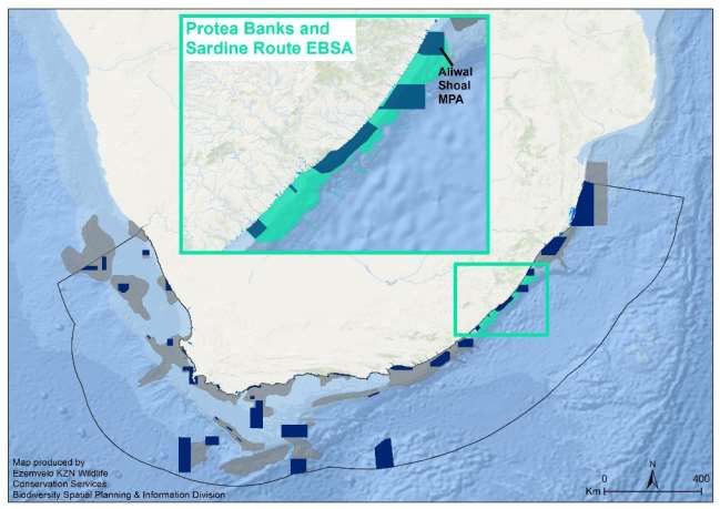
DRAFT Management Plan (Public Consultation)
                                       ALIWAL SHOAL MARINE PROTECTED AREA

Contents
Authorization ....................................................................................................................................................... 1

Contents .............................................................................................................................................................. 2

Acknowledgements.............................................................................................................................................. 5

Acronyms and Abbreviations ............................................................................................................................... 5

1      Introduction ................................................................................................................................................. 7

2      Legal Status .................................................................................................................................................. 9

    2.1        Co-Management Agreement ............................................................................................................... 9

    2.2        Location and total area ........................................................................................................................ 9

    2.3        Contractual Agreements .................................................................................................................... 10

    2.4        Municipal Areas ................................................................................................................................. 12

    2.5        International Listing ........................................................................................................................... 12

3      Policy Framework....................................................................................................................................... 13

    3.1        Global Legal Instruments ................................................................................................................... 13

    3.2        National legal instruments ................................................................................................................. 15

    3.3        Other legislations, plans and policies ................................................................................................. 16

4      Consultation ............................................................................................................................................... 16

5      Purpose and Draft Vision ........................................................................................................................... 18

    5.1        Purpose of the Aliwal Shoal MPA ....................................................................................................... 18

    5.2        Draft Vision for the Aliwal Shoal MPA ................................................................................................ 18

    5.3        Key Determining Factors .................................................................................................................... 19

       5.3.1          Ecosystem types ........................................................................................................................ 19

       5.3.2          Physical oceanographic features................................................................................................ 21

       5.3.3          Bathymetry and Seafloor Characteristics ................................................................................... 21

       5.3.4          Key fauna ................................................................................................................................... 22

                                                 2
Aliwal Shoal MPA Management Plan DRAFT Public Consultation Version: 23 March 2021
5.3.5           Ecological Processes................................................................................................................... 24

      5.3.6           Potential climate change impacts .............................................................................................. 24

    5.4       Strengths, Weaknesses, Opportunities and Threats .......................................................................... 25

    5.5       Management Objectives .................................................................................................................... 26

      5.5.1           Proposed Management Principles ............................................................................................. 26

      5.5.2           Management Objectives ............................................................................................................ 27

6     Zoning Plan ................................................................................................................................................ 30

    6.1       Inshore Zonation ................................................................................................................................ 30

    6.2       Offshore Zonation .............................................................................................................................. 31

    6.3       Regulations ........................................................................................................................................ 35

      6.3.1           Inshore ....................................................................................................................................... 35

      6.3.2           Offshore ..................................................................................................................................... 35

      6.3.3           Pelagic Fish List .......................................................................................................................... 36

7     Access and Facilities ................................................................................................................................... 36

    7.1       Access Points...................................................................................................................................... 36

    7.2       Fisheries and Resource use ................................................................................................................ 37

    7.3       Shark and Seine Nets ......................................................................................................................... 39

    7.4       Non-Consumptive Resource Use ....................................................................................................... 39

    7.5       Industrial pollution ............................................................................................................................. 39

    7.6       Estuaries ............................................................................................................................................ 40

    7.7       Heritage and Cultural resources ........................................................................................................ 40

    7.8       Tourism .............................................................................................................................................. 40

    7.9       Mining and oil and gas exploration .................................................................................................... 41

8     Consolidation and Expansion Strategy ....................................................................................................... 41

9     Concept Development Plan ....................................................................................................................... 42

10         Strategic Plan ......................................................................................................................................... 42

    10.1      Theme 1: Governance and Stakeholder involvement ........................................................................ 43

    10.2      Theme 2: Biodiversity and Conservation ........................................................................................... 48

    10.3      Theme 3: Socio-economic benefits - Natural Resource use, Recreation, Tourism, Heritage and Culture
              51

    10.4      Theme 4: Compliance and Enforcement............................................................................................ 53

                                                 3
Aliwal Shoal MPA Management Plan DRAFT Public Consultation Version: 23 March 2021
10.5      Theme 5: Disaster management ........................................................................................................ 56

  10.6      Theme 6: Planning ............................................................................................................................. 58

  10.7      Theme 7: Education and Public awareness ........................................................................................ 60

  10.8      Theme 8: Monitoring, Research and Information management ....................................................... 62

  10.9      Management Effectiveness................................................................................................................ 65

11       Research and Monitoring Programme ................................................................................................... 65

12       Costing ................................................................................................................................................... 66

13       References ............................................................................................................................................. 67

                                                 4
Aliwal Shoal MPA Management Plan DRAFT Public Consultation Version: 23 March 2021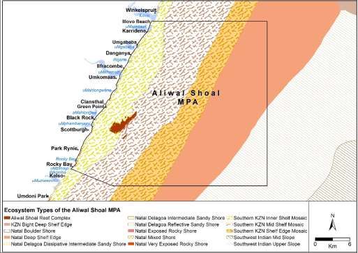
Acknowledgements

Acronyms and Abbreviations
CBD            Convention on Biological Diversity

CBA            Critical Biodiversity Area

DDG            Deputy Director General

DEA            Department of Environmental Affairs

DEFF           Department of Environment, Forestry and Fisheries

DMRE           Department of Mineral Resources and Energy

EBSA           Ecologically and Biologically Significant Area

EEZ            Exclusive Economic Zone

FAO            Food and Agriculture Organisation

IMO            International Maritime Organisation

LME            Large Marine Ecosystem

MCS            Monitoring Control and Surveillance

MIMS           Marine Information Management System

MLRA           Marine Living Resources Act,

MPA            Marine Protected Area

MSC            Marine Stewardship Council

NEM:PAA        National Environmental Management: Protected Areas Act

NPAES          National Protected Area Expansion Strategy

NSRI           National Sea Rescue Institute

OCIMS          Oceanographic and Coastal Information Management System

SAEON          South African Environmental Observation Network

SAPS           South African Police Service

                                                 5
Aliwal Shoal MPA Management Plan DRAFT Public Consultation Version: 23 March 2021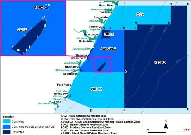
LIST OF FIGURES
Figure 1: Locality map of the Aliwal Shoal MPA ................................................................................................. 10
Figure 2: Municipal Areas adjacent to the Aliwal Shoal Marine Protected Area ................................................ 12
Figure 3: Aliwal Shoal overlaid on the Protea Banks and Sardine Route EBSA ................................................... 13
Figure 4: Marine Ecosystems associated with the Aliwal Shoal Marine Protected Area .................................... 20
Figure 5: Inshore zonation of the Aliwal Shoal MPA .......................................................................................... 31
Figure 6: Offshore zonation of the Aliwal Shoal MPA (Source: Government Gazette No. 42479, May 2019). .. 33
Figure 7: Aliwal Shoal MPA Signage Board indicating the rules and regulations related to the MPA ................ 37
Figure 8: Boat Launch Sites within the Aliwal Shoal MPA .................................................................................. 38

                                                 6
Aliwal Shoal MPA Management Plan DRAFT Public Consultation Version: 23 March 2021
1   Introduction
With the current rate of global development, human well-being in both the developing and developed world is
increasingly dependent upon the ability of marine and coastal ecosystems to provide a range of ecosystem
services. Unless these uses are managed sustainably, the users of marine ecosystems can threaten, change and
destroy the very ecosystems and services upon which they depend. In recent years there has been increasing
recognition of the threats to marine species and ecosystems, and a growing focus on the conservation of marine
biodiversity. The establishment of Marine Protected Areas (MPAs) is one of the key strategies by which the
biodiversity and ecosystems of the world’s oceans are effectively managed. MPAs can help protect marine
habitats, species and representative communities, as well as ecological systems and processes. MPAs can also
assist in restoring the productivity of marine and coastal habitats, reduce further degradation and mitigate the
impacts of climate change. In some cases, MPAs can also contribute to the socio-economic welfare of coastal
communities. In recognition of the importance of the sustainable management and protection of marine and
coastal ecosystems, the Convention on Biological Diversity (CBD) Strategic Action Plan for Biodiversity 2011-
2020 encourages all signatory nations to ensure that “by 2020, 10% of coastal and marine areas, especially
areas of particular importance for biodiversity and ecosystem services, are conserved through effectively and
equitably managed, ecologically representative and well connected systems of protected areas……” (Aichi
Target 11).

Levels of marine biodiversity protection were raised as a key concern in South Africa’s first National Spatial
Biodiversity Assessment (Driver et al. 2005). With a view to expanding the protected area estate of South Africa
generally, the former Department of Environmental Affairs (DEA, now the Department of Environment, Forestry
and Fisheries – DEFF) developed a National Protected Area Expansion Strategy (NPAES), approved in 2009,
which highlighted the lack of offshore MPAs, especially areas zoned for no-take. The offshore expansion of
South Africa’s MPA network was identified as a national priority and a collaborative five-year Offshore Marine
Protected Area project was undertaken to support the identification of a network of potential offshore spatial
management measures including MPAs. Using systematic conservation planning, ten priority focus areas were
identified for offshore biodiversity protection (Sink et al. 2011). Within KwaZulu-Natal (KZN) the provincial
conservation agency Ezemvelo KwaZulu-Natal Wildlife (Ezemvelo), developed a detailed coastal and marine
biodiversity plan for the province (Harris et al. 2012). Known as SeaPLAN, this extensive work provided a
systematic framework for assessment of the status of biodiversity protection within the Exclusive Economic
Zone (EEZ) off KZN and enabled planning for marine biodiversity protection by identifying spatial priorities for
ongoing and future marine conservation efforts in the province.

In 2014, South Africa embarked on the Phakisa Oceans Economy initiative aimed at unlocking economic
development in South Africa’s Oceans space. The Phakisa Oceans Economy Lab was based on the Big Fast
Results (BFR) methodology developed by the Malaysian government and adapted to the South Africa
environment. The Marine Protection Services and Ocean Governance Lab was one of four different growth
areas that were prioritized during the Operation Phakisa LAB process, these were 1) Marine Transport and
Manufacturing, 2) Oil and Gas, 3) Aquaculture and 4) Marine Protection and Governance Lab (MPG). The MPG
lab focused on the need to develop an integrated ocean governance plan and identified that in order to

                                                 7
Aliwal Shoal MPA Management Plan DRAFT Public Consultation Version: 23 March 2021
sustainably manage growth within the ocean environment the conservation of the ecosystems and biodiversity
also had to be considered through a representative network of marine protected area. The offshore priority
areas identified by Sink et al. (2011) and Harris et al. (2012) provided the basis for a proposed expanded MPA
network. The Operation Phakisa thus proposed a network of 22 new and expanded MPAs (including the Addo
Elephant MPA which had already been submitted to the Minister for consideration). These proposed MPAs
were gazetted for public comment in February 2016 (Operation Phakisa 2014; Government Gazette No. 39646
of 3 February 2016).
After stakeholder engagement and the public participation process, 20 of the 22 proposed MPAs defined in the
Operation Phakisa process were finally declared on the 23 May 2019, moving South Africa closer to the CBD
Aichi 11 target of 10% marine protection. South Africa now has a total of 42 MPAs, 41 within the ocean territory
of mainland South Africa, and one very large MPA, the Prince Edwards Islands MPA declared in 2013, in the
Southern Ocean territory. Approximately 5.4% of the mainland’s EEZ is now formally protected under MPA
designation and more details can be found in the technical report (Sink et al. 2019d).
The expansion of the Aliwal Shoal MPA was one of the 20 MPAs proclaimed in May 2019. The Aliwal Shoal MPA
was originally proclaimed in 2004 under section 43 of Marine Living Resources Act 18 of 1998 (Government
Gazette No. 26433 of 4 June 2004) after extensive public participation and deliberation that lasted nearly 20
years (Trebble and Schleyer 1999). The Aliwal Shoal MPA itself is an extensive reef system situated
approximately 4 km off Green Point on the KZN south coast, about 45 km south of Durban. Apart from being a
hazard to shipping (it was originally named by Captain James Anderson aboard the vessel Aliwal that nearly
came to grief on the Shoal in 1849), this area has been a well-known fishing destination for boat-based line-
fishermen since the early 1900s (Mara 1986), and with spearfishermen since the 1960s (Venter 1971). With the
growth in popularity of scuba diving in the early 1980s (Goldberg 2006), Aliwal Shoal became the second most
frequented diving destination in South Africa after Sodwana Bay (Mann and Mann 2003). Over time the high
levels of use on the reef by line-fishermen, spearfishermen, scuba divers, and later by shark diving enthusiasts,
resulted in considerable user conflict, especially on the so-called “Crown Area” of the reef. This conflict together
with the high biodiversity and the over-exploitation of some of the reef fish species led to the identification and
subsequent proclamation of the Aliwal Shoal MPA in 2004. The original MPA extended from the south bank of
the Umkomaas River to the Mzimayi River (18 km) and for 7 km seawards (Government Gazette No. 26433,
2004). However, only the Crown Area of the Aliwal Shoal (2.5 km)2 and the wreck of the Produce (0.4 km2) were
zoned as no-take restricted areas, while the rest of the MPA was zoned as a controlled area where consumptive
use such as line-fishing and spearfishing was allowed (Government Gazette No. 26433).
The expansion and re-zonation of an existing MPA was seen to be more practical and spatially efficient as
opposed to trying to protect a completely new marine area. It was for this reason together with the presence
of important offshore ecosystems, process and species existing just outside of the existing MPA, that the
expansion both northwards and offshore of the existing Aliwal Shoal MPA was identified and put forward, as
one of the 22 MPAs in the Operation Phakisa process (Operation Phakisa 2014). Following a long public
participation process initiated during the SeaPLAN project and intensified in February 2016 as part of the
Operation Phakisa process, the new and expanded Aliwal Shoal MPA was proclaimed in May 2019. It included
both an offshore extension (17 km offshore in the north and 29 km in the south) and an 11 km northward
8
Aliwal Shoal MPA Management Plan DRAFT Public Consultation Version: 23 March 2021extension to just south of the Lovu River (Figure 1). The MPA was completely re-zoned to include a greater level
of no-take protection of both inshore and offshore habitats and now includes the protection of several
threatened ecosystem types.
It is a requirement of the National Environmental Management: Protected Areas Act (NEM:PAA, Section 39(2))
that each Protected Area has a management plan to guide the development and management of the area to
meet the purpose for which it was declared. The purpose of the Aliwal Shoal MPA Draft Management Plan
developed below is to ensure that the Aliwal Shoal MPA has clearly defined management objectives and
proposed activities to direct the protection and sustainable use of its natural resources over a ten-year time
horizon. The Draft Management Plan indicates where the MPA management authority should focus its efforts
in the next ten years, providing a medium-term operational framework for the prioritized allocation of resources
and capacity in the management, use and development of the MPA. The drafting of the Management Plan
follows the Guidelines for Development of a Management Plan for a Protected Area in terms of NEM:PAA, and
the Norms and Standards for the Management of Protected Areas in South Africa.
2 Legal Status
The Aliwal Shoal MPA was first proclaimed on 4 June 2004 in Notice 697 of Government Gazette 26433, under
section 43 of the Marine Living Resources Act (Act No. 18 of 1998). This was withdrawn and the expanded MPA
was re-proclaimed under the National Environmental Management: Protected Areas Act, 2003 (Act No. 57 of
2003), in Notice 759 of Government Gazette 42478, in May 2019. This was after the expanded MPA had been
proposed and gazetted for public comment in February 2016 through Operation Phakisa (2014) and where
relevant public comments had been considered and incorporated where possible.
2.1 Co-Management Agreement
The expanded Aliwal Shoal MPA has only recently been declared and currently there are no co-management
arrangements in place.
2.2 Location and total area
The Aliwal Shoal MPA is located east of Umkomaas on the southern KZN coast approximately 45 km south of
Durban. The MPA extends for a distance of 29 km along the coast from just south of the Lovu River mouth to
the Mzimayi River mouth near Rocky Bay (Figure 1). The northern boundary extends 17 km out to sea, while
the southern boundary extends 29 km out to sea, both boundary lines being parallel to the lines of latitude
(east-west). The eastern (offshore) boundary line is 29 km long and parallel to the lines of longitude. The depth
range in the MPA is from 0 m on the shoreline to -800 m on the upper slope at the southeast edge of the MPA.
The total area of the MPA is 677 km2. The coordinates for the boundaries of the Aliwal Shoal MPA are provided
in Appendix 1.
9
Aliwal Shoal MPA Management Plan DRAFT Public Consultation Version: 23 March 2021Figure 1: Locality map of the Aliwal Shoal MPA
2.3 Contractual Agreements
The management of the marine environment and its living resources is a national responsibility undertaken in
the first place by the Minister of Forestry, Fisheries and the Environment who is mandated to give effect to
Section 24 of the Constitution (a healthy environment, conserved and used sustainably). The Minister may
delegate the management of the environment and protected areas to provincial or municipal authorities and
with regard to the management of the Aliwal Shoal MPA, management has been delegated to the Provincial
Conservation Agency, Ezemvelo KZN Wildlife (Ezemvelo) as per NEM:PAA section 38(1) and through the
Management Agreement. Ezemvelo is responsible for biodiversity conservation and the management of nature
conservation including protected areas within the Province of KwaZulu-Natal. This mandate is derived from the
KwaZulu-Natal Conservation Management Act (Act No. 9 of 1997). The implementation of awareness and
compliance as well the management plan will be the responsibility of Ezemvelo.
10
Aliwal Shoal MPA Management Plan DRAFT Public Consultation Version: 23 March 2021An Organogram of the Organisation Structure and Link to the DEFF is represented below:
Minister of Environment, Forestry Ezemvelo KZN Wildlife Board
and Fisheries
Memorandum
Deputy Director-General Oceans of Agreement Ezemvelo KZN Wildlife
and Coasts –
Chief Executive Officer
Delegation of
Management Authority
Head of Conservation Operations
Regional Manager East
(Project Manager)
Scientific District Conservation Manager
Support &
Ezemvelo Advice
Conservation
Services Administrative Conservation Manager UGU
Support (Marine)
X Field Rangers Skipper
Protected Area Staff
11
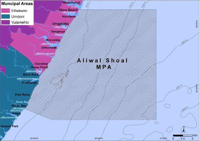
Aliwal Shoal MPA Management Plan DRAFT Public Consultation Version: 23 March 20212.4 Municipal Areas
The Aliwal Shoal MPA lies partly in the eThekwini Metro (the southern boundary of the Metro is the
aMahlongwa River) and partly in the Umdoni Local Municipality located in the Ugu District Municipality (Figure
2).
Figure 2: Municipal Areas adjacent to the Aliwal Shoal Marine Protected Area
2.5 International Listing
The biodiversity significance of the Aliwal Shoal and surrounding area was captured in SeaPLAN and it was
prioritized as a Critical Biodiversity Area (Harris et al. 2012). Its importance was underlined by the inclusion of
the area in the Protea Banks and Sardine Route ecologically or biologically significant marine area (EBSA) that
covers 9345 km2 of the shelf between Aliwal Shoal MPA (Figure 3) and Dwesa MPA (Convention on Biological
Diversity COP 12 2014; MARISMA Project 2020). The main justifications for the EBSA, in terms of scientific
criteria established by the CBD, are Uniqueness or rarity (migratory route of sardines and a unique deep reef
features); Special importance for life history stages (spawning aggregation site for several species, key feeding
area for predators following the sardines, breeding and nursery ground for sparids); Importance for threatened,
endangered or declining species (refuge area for over-exploited sparids and scaenids, 20 threatened ecosystem
types); and biological diversity (high habitat and species diversity).
12
Aliwal Shoal MPA Management Plan DRAFT Public Consultation Version: 23 March 2021Figure 3: Aliwal Shoal overlaid on the Protea Banks and Sardine Route EBSA
3 Policy Framework
International laws and agreements as well as National Acts and Policies underpin the proclamation of MPAs and
direct the planning and operational management activities that occur within the MPA. Section 41 of the
NEM:PAA requires that management plans be located within the context of a Coordinated Policy Framework.
The legislative instruments outlined below provide the policy framework for Management Planning in the
marine environment.
3.1 Global Legal Instruments
The United Nations Law of the Sea (UNCLOS) is a binding agreement which provides a comprehensive
framework for the governance of the oceans and their resources. States have a general obligation to
protect and preserve the marine environment. Coastal States can, with the consent of the International
Maritime Organisation (IMO) and without hampering the freedom of navigation of foreign vessels,
adopt special measures to reduce the risk of ship-based pollution in specific designated areas.
The International Convention for the Prevention of Pollution from Ships (1973) and its 1978 Protocol
together known as MARPOL 73/78, is the principle IMO treaty dealing with the threat of pollution from
ships. In 1991 the IMO Assembly adopted Resolution A.720 (17), which allowed for the designation of
Particularly Sensitive Sea Areas (PSSAs).
13
Aliwal Shoal MPA Management Plan DRAFT Public Consultation Version: 23 March 2021The Convention on Biological Diversity requires States to establish a system of protected areas, to
develop, guidelines for the selection, establishment and management of protected areas and to
develop national strategies, plans or programmes for the conservation and sustainable use of biological
diversity. The Aichi target 11 states that at least 17% of terrestrial and inland waters and 10% of coastal
and marine areas should be conserved by 2020 through a well-connected system of protected areas
and other effective area-based conservation measures, which should be effectively and equitably
managed, and ecologically representative.
The Nagoya Protocol on Access to Genetic Resources and the Fair and Equitable Sharing of Benefits
Arising from their Utilization (ABS) to the Convention on Biological Diversity is a supplementary
agreement to the Convention on Biological Diversity. It provides a transparent legal framework for the
effective implementation of one of the three objectives of the CBD: the fair and equitable sharing of
benefits arising out of the utilization of genetic resources.
South Africa is signatory to the World Summit on Sustainable Development Plan of Implementation
(2002) and is thereby committed to establishing and implementing an ecosystem approach to fisheries
(EAF) in the country by 2010.
The 2003 World Parks Congress set specific goals as to the extent of effectively managed, representative
networks of marine and coastal protected areas.
The 2014 World Parks Congress where South Africa pledged in the “Promise of Sydney” to triple the
oceans protection over the next ten years through the creation of a network of Marine Protected Area
within its Exclusive Economic Zone.
The Agreement on the Conservation of Albatrosses and Petrels which South Africa has ratified, places
obligations on states to protect habitats that are important for the survival of these species.
The FAO Code of Conduct for Responsible Fisheries is a voluntary instrument which sets international
standards and behaviours for governments and other stakeholders to bring about responsible practices
for the effective conservation, management and development of living aquatic resources.
The International Plan of Action to Prevent, Deter and Eliminate IUU Fishing is a voluntary instrument
that has been elaborated within the framework of the FAO Code of Conduct for Responsible Fisheries
and provides a range of measures for combatting IUU fishing and promoting an integrated approach to
address all impacts of IUU fishing.
The Global Record of Fishing Vessels, Refrigerated Transport Vessels and Supply Vessels is a compilation
of certified information on vessels involved in fishing operations, providing a tool with which to combat
IUU fishing.
The Port State Measures Agreement, to which South Africa is a signatory, includes all the internationally
acceptable measures for port state control of fishing vessels in order to eliminate IUU fishing activities.
The African Integrated Maritime Strategy includes a plan of action to address IUU fishing and reinforces
the call for cooperation across states, Regional Economic Communities and Regional Fisheries
Management Organisations.
14
Aliwal Shoal MPA Management Plan DRAFT Public Consultation Version: 23 March 2021The Convention on International Trade in endangered Species of Wild Fauna and Flora (CITES) which in
an international agreement between Governments which ensures that the trade in wild plants and
animals does not threaten their survival.
3.2 National legal instruments
The current legal framework that directs planning and operational management activities in MPAs is largely
contained in the following legislation:
The Constitution of the Republic of South Africa Act, No. 108 of 1996. Section 24 provides the right to
every person for a non-harmful environment and simultaneously mandates the government to protect
the environment.
The National Environmental Management Act, No. 107 of 1998 (amended 2013) is the statutory
framework to enforce Section 24 of the Constitution. It provides for co-operative, environmental
governance by establishing principles for decision-making on matters affecting the environment.
The National Environmental Management: Biodiversity Act, No. 10 of 2004 (amended 2014) provides
for the management and conservation of South Africa's biodiversity within the framework of
the National Environmental Management Act.
The National Environmental Management: Protected Areas Act, No. 57 of 2003 (amended 2014)
provides for the protection and conservation of ecologically viable areas representative of South
Africa's biological diversity. MPAs are declared under the National Environmental Management:
Protected Areas Amendment Act, 2014.
The Marine Living Resources Act, No. 18 of 1998 (amended 2014) provides for the conservation of the
marine environment, the long-term sustainable utilisation of marine living resources and the orderly
access to exploitation, utilisation and protection of certain marine living resources.
The National Heritage Resources Act, No. 25 of 1999 ensures that the national heritage is conserved
and protected.
The Sea Birds and Seals Protection Act, No. 46 of 1973 provides for the protection of sea birds and seals.
The National Environmental Management: Integrated Coastal Management Act, No. 24 of 2008
establishes a system of integrated coastal and estuarine management in South Africa which includes
norms, standards and policies, in order to promote the conservation of the coastal environment.
The Minerals and Petroleum Resources Development Act No 28 of 2002 (amended 2008) makes
provision for equitable access to, and sustainable development of, the nation's mineral and petroleum
resources.
The National Protected Areas Expansion Strategy (2016) seeks to achieve a representative and cost-
effective protected area network.
The Disaster Management Act, No. 57 of 2002 provides for: an integrated and co-ordinated disaster
management policy that focuses on preventing or reducing the risk of disasters.
The Merchant Shipping Act, No. 57 of 1951 (as amended) provides for the control of merchant
shipping and matters incidental thereto.
15
Aliwal Shoal MPA Management Plan DRAFT Public Consultation Version: 23 March 2021The Marine Traffic Act 2 of 1981 empowers the Minister of Transport to make regulations that regulate
marine traffic in the territorial and internal waters of South Africa.
The Maritime Zones Act 15 of 1994 asserts South Africa’s right under the United Nations Law of the
Sea Convention (LOSC) to a Territorial Sea (12 nautical miles from coast) and an Exclusive Economic
Zone (EEZ) extending 200 nautical miles to sea from the coastal baselines.
The Marine Pollution (Prevention of Pollution from Ships) Act 2 of 1986 empowers the Minister of
Transport to make regulations that give effect to the MARPOL 73/78 Convention.
The Marine Spatial Planning Act No. 16 of 2018 provides a framework for marine spatial planning in
South Africa.
Public Finance Management Act, 1999 (Act 1 of 1999)
The Spatial Planning and Land Use Management Act (SPLUMA) 16 of 2013 which allows the Department
of Rural Development and Land Reform (DRDLR) to pass regulation related to land development and
land use.
The Local Government: Municipal Systems Act 32 of 2000 which defines the legal nature of
municipalities as part of a system of co-operative government.
The Intergovernmental Relations Framework Act (IGRF) 13 of 2005 which establishes a framework for
the national, provincial and local government to interact.
The Bioprospecting, Access and Benefit Sharing (BABS) Regulations, 2008 made under the National
Environmental Management Biodiversity Act (NEMBA), Act 10 of 2004
3.3 Other legislations, plans and policies
Integrated Development Plans (IDPs) for the eThekweni metropolitan municipality, the Ugu District
Municipality and Umdoni Local Municipality
KZN Provincial Growth and Development Strategy, 2035 (2016)
KwaZulu-Natal Conservation Management Act (Act No. 9 of 1997)
4 Consultation
The NEM:PAA Section 31, 32 and 33 public participation requires the participation of civil society and other
authorities in the governance of protected areas and thus once a Draft Management Plan has been developed,
a formally constituted Aliwal Shoal Stakeholder Forum under the chair of Ezemvelo, should be responsible for
guiding the ongoing development, review, evaluation, and updating of the components of the MPA
management plan. The stakeholder forum that was constituted in 2014 during the Operation Phakisa Process
prior to the declaration the Aliwal Shoal MPA would need to be re-constituted and formalised. The management
agency will need to consult regularly with the formalised Aliwal Shoal Stakeholder Forum to maintain an
effective consultative management programme.
The following should apply to the formation and functioning of the Stakeholder Forum: Terms of references are
as follows
• The different stakeholder groups to be represented on the Forum should be clearly defined.
16
Aliwal Shoal MPA Management Plan DRAFT Public Consultation Version: 23 March 2021• The Stakeholder Forum should be structured to ensure that a platform is not created in which specific
stakeholder interests are perceived to dominate the functioning of the Forum.
• The size of the Forum should be contained to a manageable size with representatives from each
stakeholder group attending and reporting back to their respective members.
• Each stakeholder group representative should have a clear mandate to represent the interests of the
stakeholders he/she represents and a mechanism to report back to their constituency
• The Aliwal Shoal Stakeholder Forum should be formalised by the adoption of a constitution.
• DEFF/Ezemvelo should commit to actively providing administrative and logistical support in the
functioning of the Stakeholder Forum
• The Forum should meet at least four times a year
The major stakeholders for the Aliwal Shoal MPA and its immediate surrounds are:
DEFF: Branch Ocean and Coasts as the national management authority
KZN Department of Economic Development, Tourism and Environmental Affairs
Ezemvelo KwaZulu-Natal Wildlife (Ezemvelo) as the delegated provincial management authority
eThekwini Municipality
Ugu District Municipality
Umdoni Local Municipality
Local rate payers’ associations
South African Police Service (SAPS) Marine Unit
KwaZulu-Natal Sharks Board
SCUBA diving fraternity
Shark diving fraternity
Recreational spearfishing sector
Recreational ski-boat fishing sector
Recreational shore angling sector
Charter-boat fishing sector
Commercial ski-boat fishing sector
Small-scale fishing sector
National Sea Rescue Institute (NSRI)
SAPPI - SAICCOR
Coastal conservancies
Research organisations (e.g. Oceanographic Research Institute, University of KwaZulu-Natal, Council for
Scientific and Industrial Research, etc.)
NGOs (e.g. Wild Oceans, Coast Watch)
17
Aliwal Shoal MPA Management Plan DRAFT Public Consultation Version: 23 March 20215 Purpose and Draft Vision
5.1 Purpose of the Aliwal Shoal MPA
The selection of the Aliwal Shoal MPA was driven by the inclusion of a variety of representative ecosystem types
in good condition within the area, as well as the deliberate selection of a few vulnerable and endangered
ecosystem types.
The gazetted purposes of the new Aliwal Shoal MPA are:
a) To contribute to a national, regional and global representative system of MPAs by conserving and
protecting coastal and offshore benthic and pelagic ecosystems comprising of reef complexes, deep
reefs, and other ecosystems on the shelf and including threatened ecosystem types.
b) To conserve and protect the biodiversity and ecological processes associated with these ecosystems,
including protected, threatened or overexploited species such as tiger sharks, red steenbras, seventy-
four, geelbek and dusky kob and processes such as the sardine run.
c) To facilitate species management and sustainable use of line-fish, subtidal and intertidal resources by
supporting fisheries recovery and enhanced species abundance in fished areas.
d) To support the recovery of line-fish and sharks by protecting spawning, nursery, foraging, aggregation,
and refuge areas.
e) To conserve and protect an area of life history importance for migratory species including seabirds,
turtles, sharks, seabreams and other fish.
f) To support sustainable nature-based tourism opportunities in the area through the protection of
marine wildlife and maritime heritage.
g) To protect and regulate a scenic area to support sustainable nature-based tourism, cultural and spiritual
assets and a functionally connected coastal marine system to retain a land-ocean ‘sense of place’.
h) To protect and provide an appropriate environment for research and monitoring particularly research
on recovery of linefish, and also to promote and contribute to environmental education.
(Government Gazette No. 42478, 23 May 2019)
5.2 Draft Vision for the Aliwal Shoal MPA
To effectively manage the Aliwal Shoal MPA and its various user groups in a way that maintains its conservation
value and ecological integrity, contributes to the sustainable management of marine resources and the
promotion of eco-tourism and provides long-term economic benefits to surrounding communities.
(Vision to be revised with stakeholders)
18
Aliwal Shoal MPA Management Plan DRAFT Public Consultation Version: 23 March 20215.3 Key Determining Factors
5.3.1 Ecosystem types
The Aliwal Shoal MPA is situated in the Natal ecoregion, one of four main shelf ecoregions described for South
Africa (Sink et al. 2019a). The MPA includes 11 ecosystem types (Table 1). The latter include Natal Mixed Shore,
the Aliwal Shoal Reef Complex itself, the Southern KZN Inner Shelf Mosaic and the Southern KZN Mid Shelf
Mosaic. An overview of the ecosystem types that have been identified within the MPA is provided in the table
below and in Figure 4.
Table 1: Overview of ecosystem types found in the Aliwal Shoal MPA (for specific descriptions of each
ecosystem type see Sink et al. 2019a, b, c, d). EN = Endangered, LC = Least Concern, NT = Near Threatened,
VU = Vulnerable
Description Percentage of
Aliwal Shoal NBA NBA Area Total
ecosystem type
Threat Protection Protected in Extent
Marine Protected Area protected in this
Status Level* this MPA (km2) (km2)
MPA
A 3 km long by 380 m wide major
shallow reef on an aeolianite ridge on
the inner shelf in the Natal ecoregion.
Aliwal Shoal Reef
Reef rises from -30 m to just 6 m VU MP 5.22 5.22 100.00%
Complex
below sea level. Algal dominated
(brown and corallines) with soft and
hard corals and sponges
Unknown seafloor habitat on the shelf
edge of the southern part of the Natal
Natal Deep Shelf Edge ecoregion extending approximately LC MP 209.87 1377.22 15.24%
between -200 and -500 m, between
Durban and East London
Natal Delagoa Fine grained, sloping sandy shore with
Intermediate Dissipative moderately wide beach and surf zone LC WP 0.50 32.85 1.53%
Sandy Shore width in the Natal-Delagoa Province
Beach with medium grain size and
Natal Delagoa moderate slope in the Natal-Delagoa
NT WP 2.70 52.12 5.18%
Intermediate Sandy Shore Province. Often with cusps on the
shore and sandbars and rips in the surf
Rocky shore type in the Natal
Natal Exposed Rocky
ecoregion exposed to moderate wave NT WP 0.26 31.48 0.82%
Shore
intensity
Shore with both rocky and sandy
Natal Mixed Shore VU WP 4.06 69.52 5.84%
habitat in the Natal ecoregion.
Rocky shore type in the Natal
Natal Very Exposed Rocky
ecoregion exposed to high wave NT WP 0.03 0.96 2.84%
Shore
intensity
19
Aliwal Shoal MPA Management Plan DRAFT Public Consultation Version: 23 March 2021Description Percentage of
Aliwal Shoal NBA NBA Area Total
ecosystem type
Threat Protection Protected in Extent
Marine Protected Area protected in this
Status Level* this MPA (km2) (km2)
MPA
Mosaic seafloor (rocky and sandy) and
moderate turbidity warm pelagic
Southern KZN Inner Shelf habitat on the inner shelf
EN MP 99.51 258.87 38.44%
Mosaic (approximately -7 to -30 m) between
Durban and Port Edward in the Natal
Shelf ecoregion
Current swept mosaic seafloor
comprised of rocky and coarse to very
Southern KZN Mid Shelf
coarse sand, -30 to -80 m between EN MP 178.15 989.63 18.00%
Mosaic
Durban and Port Edward in the Natal
Shelf ecoregion
Mosaic reef and coarse sandy seabed
with high current and warm clear
Southern KZN Shelf Edge
water on the shelf edge between NT WP 121.86 669.56 18.20%
Mosaic
Durban and Port Edward in the Natal
ecoregion
Unclassified seabed, -500 to -1000 m
Southwest Indian Upper
in the Southwest Indian Deep Ocean LC WP 54.90 17527.17 0.31%
Slope
ecoregion
*MP = Medium Protection, WP = Well Protected
Figure 4: Marine Ecosystems associated with the Aliwal Shoal Marine Protected Area
20
Aliwal Shoal MPA Management Plan DRAFT Public Consultation Version: 23 March 20215.3.2 Physical oceanographic features
The Aliwal Shoal MPA is situated on a relatively narrow (15 km) part of the continental shelf south of Durban.
Thus, the oceanography of the region tends to be dominated by the powerful, southward flowing, Agulhas
Current with a mean speed of 1.5 m.s-1 (Lutjeharms 2006). Inshore, sea surface temperatures range from 18-
26°C with the highest temperatures recorded in summer (Jan-Feb) and the lowest during winter (Jul-Aug; KZN
Sharks Board unpublished data). Offshore the water clarity is normally good since the water is made up of warm,
nutrient-poor, Agulhas water. Inshore the water can be extremely turbid, especially during the summer months
following periods of heavy rainfall and discharge of the sediment laden Umkomaas River into the sea. During
the summer months a thermocline often develops on the shelf inshore of the Agulhas Current and this
thermocline moves further inshore (upwelling) following periods of strong north-easterly winds, resulting in
decreased water temperature, increased primary productivity and an associated decrease in underwater
visibility. The thermocline generally breaks down during the winter months with the regular passing of cold
fronts and the associated strong south-westerly winds and large swell which result in downwelling and mixing
of the water column.
The occurrence of the Durban Eddy just south of Durban is an important oceanographic feature in the area
(Guastella and Roberts 2016). This cyclonic eddy forms in the lee of Durban and results in localised upwelling
which brings cooler, nutrient-rich water to the surface with an associated increase in primary productivity. This
process is believed to be ecologically important and probably one of the reasons why several line-fish species
spawn in the area (Hutchings et al. 2002). The Durban Eddy and the Natal Pulse (the latter caused by a meander
in the Agulhas Current off the KZN Bight north of Durban) are also responsible for periodic changes in inshore
current direction (i.e. from the prevailing north-south to south-north), locally known as a “reverse or counter
current”. This phenomenon is believed to assist the inshore, northward migration of sardines (Sardinops sagax)
during the annual winter sardine run (Roberts et al. 2010).
The coastline is relatively straight and directly exposed to the swell, making it a very high energy environment.
The shore is made up mainly of coarse grain sandy beaches with rocky promontories at Widenham, Green Point,
Scottburgh and Rocky Bay. Seven estuaries are located in the MPA, all of which, excepting the Umkomaas, are
small, temporary open-closed type estuaries.
5.3.3 Bathymetry and Seafloor Characteristics
The depth of the MPA ranges from the inter-tidal zone to depths of about -800 m on the continental shelf slope
of the southeast boundary. The location of reef systems within the MPA has received most research interest
(Harris et al. 2012). Rocky reefs are found close to the shore, particularly off prominent headlands, and are
mainly an extension of rocks found on land. These reefs protrude where currents or wave action is strong
enough to keep the reefs clear of sediment (Branch and Branch 2018). The Aliwal Shoal reef complex, Protea
Banks and other offshore reefs at similar depths between Durban and Port Grosvenor were formed during the
Late Pleistocene period when the sea level was about 150 m lower than its current level. This consolidated
aeolianite ‘beach rock’ now forms a ridge of reefs parallel to the coast on the middle to outer shelf area between
Durban and Port Grosvenor. The ridge forms a barrier to cross-shelf sediment dispersal and limits the erosive
21
Aliwal Shoal MPA Management Plan DRAFT Public Consultation Version: 23 March 2021influence of the Agulhas Current on the shoreward side of the ridge (Bosman et al. 2005; De Wet 2012). As a
result, the inner self is characterised by a thick sediment layer of terrigenous origin (De Wet 2012).
The Aliwal Shoal is the major bathymetric features of the MPA. Aliwal Shoal is a 3 km long, 380 m wide,
northeast-southwest trending aeolianite ridge that rises from depths of -24 and -30 m to just 6 m below the
surface. The bathymetry of the Aliwal Shoal has been mapped in detail by Bosman et al. (2005) using side-scan
sonar.
Deeper reefs further offshore are also present and represent more ancient dune cordons. Some recent surveys
have led to some of the first footage of these reefs, while seafloor and fish surveys will provide a greater
understanding of these systems (ACEP Surrogacy and Spatial Solutions Project). Very deep reefs (> 200 m) occur
on the shelf slope as a result of the scouring effect of the Agulhas Current, but little is known about these deep
reef habitats.
The marine geology of the inner shelf in the Aliwal Shoal MPA is dominated by terrigenous sediments largely
associated with input from large river systems like the Illovu, Umkomaas and Mpambanyoni Rivers (Flemming
1981). In recent times poor agricultural practises and increased rates of erosion within the catchment area have
greatly increased sediment loads flowing into the marine environment. The mid-shelf ridge limits the dispersal
of these sediments across the shelf. Because of the strong Agulhas Current on the outside of the ridge, no
significant sediment accumulation exists on the middle and outer shelf and most of the middle and outer shelf
sediments are relatively coarse and are dominated by shelly sand and gravel. The shelf break is about 13 km
offshore and occurs at about -100 m isobath.
5.3.4 Key fauna
Inshore the coastline of the MPA includes both rocky shores and sandy beaches. The flora and fauna on the
rocky shores has been described in detail (Sink et al. 2005) and includes key species such as brown mussels
(Perna perna), red-bait (Pyura stolonifera), Natal rock oysters (Saccostrea cucullate), barnacles (e.g. Octomeris
angulosa) and periwinkles (Afrolittorina africana), as well as a large variety of seaweeds. The sandy beaches are
dominated by species such as ghost crabs (Ocypode ryderi), mole crabs (Emerita austroafricana) and plough
snails (Bullia rhodostoma).
Within the surf-zone fish species such as strepie (Sarpa salpa), convict surgeons (Acanthurus triostegus),
blacktail (Diplodus capensis), pinkies (Pomadasys olivaceus) and stone bream (Neoscorpis lithophilus) dominate
the fish community in terms of abundance. However, key angling species such as shad (Pomatomus saltatrix),
garrick (Lichia amia), dusky kob (Argyrosomus japonicus), Natal stumpnose (Rhabdosargus sarba) and spotted
grunter (Pomadasys commersonnii) are frequently targeted in the area (Dunlop and Mann 2012). The rocky
reefs in the shallow subtidal surf-zone are dominated by red algae, especially the corallines, but key benthic
invertebrate fauna in this habitat include species such as East Coast rock lobster (Panulirus homarus), octopus
(Octopus vulgaris) and Cape oysters (Striostrea margaritacea). The sandy surf-zone supports a number of
endangered species such as giant guitarfish (Rhynchobatus djiddensis) and various ray species such as the
leopard whipray (Himantura leoparda) and sharpnose brown stingrays (Maculabatis gerrardi).
22
Aliwal Shoal MPA Management Plan DRAFT Public Consultation Version: 23 March 2021Further offshore, the fauna and flora of the Aliwal Shoal has been described in detail by Schleyer and Kay (1998),
Goldberg (2006) and Olbers et al. (2009). The reef system is characterized by an extremely rich diversity of
marine organisms and a high level of endemicity (Goldberg 2006, Olbers et al. 2009). Large shallow areas of the
shoal are dominated by the encrusting sponges such as Suberites kelleri and hard corals such as Stylophora
pistillata and Pocillopora spp. Steep edges of the shoal are characterized by an abundance of polychaete worms
and soft corals such as Eleutherobia aurea, while the deeper, offshore side of the shoal is dominated by coralline
and red foliose algae (Olbers et al. 2009). Over 361 fish species have been recorded by divers on Aliwal Shoal
(Goldberg 2006) but the reef fish community is dominated by species such as slinger (Chrysoblephus puniceus),
Natal emperor (Lethrinus scoparius), german (Pachymetopon germanum), Natal fingerfin (Chirodactylus
jessicalenorum), etc. However, many other species of sea breams (Sparidae), surgeon fishes (Acanthuridae),
butterflyfishes (Chaetodontidae), wrasses (Labridae), damselfishes (Pomacentridae) and rockcods (Serranidae)
are also present. Deeper reefs are dominated by line-fish species such as santer (Cheimerius nufar), englishman
(Chrysoblephus anglicus), false englishman (C. lophus), slinger and black musselcracker (Cymatoceps nasutus),
while species such as blue hottentot (Pachymetopon aeneum), trawl soldier (Polysteganus coeruleopunctatus)
and geelbek (Atractoscion aequidens) are common in commercial catches from this area (Dunlop and Mann
2013).
Aliwal Shoal is particularly well known for the abundance of shark species found in the area. Perhaps the most
famous are the ragged-tooth sharks (Carcharius taurus) which aggregate and mate on the shoal during spring
(Dicken et al. 2006). Blacktip sharks (Carcharhinus limbatus) and tiger sharks (Galeocerdo cuvier) are also
commonly seen on the shoal and have been the basis for an important shark diving industry established within
the MPA (Dicken and Hosking 2009). Other shark species often seen in this area include Zambezi sharks
(Carcharhinus leucas), dusky sharks (C. obscurus) and scalloped hammerhead sharks (Sphyrna lewini).
Many of the teleost (bony fish) and elasmobranch (shark and ray) species found in the Aliwal Shoal MPA are
categorised as Endangered (EN) or Critically Endangered (CE) on the IUCN Red List. These include species such
as brindle bass (Epinephelus lanceolatus, EN), seventy-four (Polysteganus undulosus, CE) dusky kob
(Argyrosomus japonicas, EN), Red steenbras (Petrus rupestris, EN), giant guitarfish (Rhynchobatus djiddensis,
CE) and scalloped hammerhead sharks (Sphyrna lewini, CE).
The pelagic environment within the Aliwal Shoal MPA is frequented by many pelagic fish ranging from small
baitfish species such as sardines (Sardinops sagax) to large gamefish species such as yellowfin tuna (Thunnus
albacares) and black marlin (Istiompax indica). These species are highly mobile and tend to move through the
area. However, the localised abundance of prey fish species within the MPA make this an important feeding
area, particularly for many of the larger gamefish species. Whale sharks (Rhincodon typus) and manta rays
(Manta birostris) are often seen passing through the area, particularly during the summer months. Migrating
loggerhead turtles (Caretta caretta) and leatherback turtles (Dermochelys coriacea) pass through the MPA,
while green turtles (Chelonia mydas) feed on the reefs within the MPA.
A variety of seabirds are found within the MPA such as kelp gulls (Larus dominicanus), white-fronted plovers
(Charadrius marginatus) and swift terns (Thalasseus bergii) and black oystercatchers (Haematopus moquini) are
occasionally seen feeding on the rocky shores.
23
Aliwal Shoal MPA Management Plan DRAFT Public Consultation Version: 23 March 2021You can also read