PSE Kinsale Energy Limited Kinsale Alpha and Bravo Platforms Shallow Geological Survey - Environmental Impact Assessment Screening/Environmental ...
←
→
Page content transcription
If your browser does not render page correctly, please read the page content below
PSE Kinsale Energy Limited

Kinsale Alpha and Bravo Platforms Shallow
            Geological Survey

   Environmental Impact Assessment
  Screening/Environmental Risk Report
               March 2020
               Rev: Issue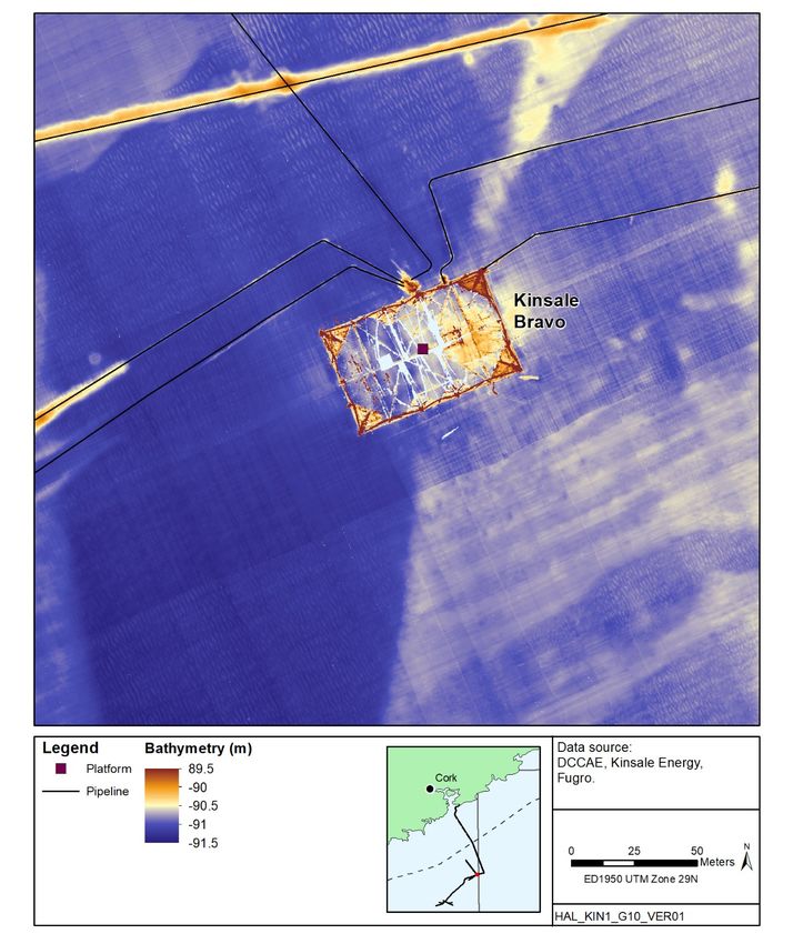
Kinsale Platform Survey:                                                                    PSE Kinsale Energy Limited
EIA Screening Report                                                                                      March 2020
                                                                                                                Page i

Contents
Glossary .................................................................................................................... ii
1     Introduction ........................................................................................................ 1
    1.1     The Applicant .............................................................................................. 1
    1.2     Background and document purpose ......................................................... 1
    1.3     Legislative background and EIA process ................................................. 1
2     Project Description ............................................................................................ 5
    2.1     Survey background and purpose .............................................................. 5
    2.2     Survey activity and equipment .................................................................. 5
    2.3     Vessel ........................................................................................................... 6
3     Environmental characteristics of the area ...................................................... 7
    3.1     Physical environment ................................................................................. 7
    3.2     Biological environment............................................................................. 10
    3.3     Other users ................................................................................................ 31
4     Identification of Potentially Significant Effects and EIA Screening ............ 36
    4.1     Introduction ............................................................................................... 36
    4.2     Approach to screening for potential effects ........................................... 36
5     Consideration of Potential Effects ................................................................. 42
    5.2     Cumulative effects .................................................................................... 51
    5.3     Transboundary effects ............................................................................. 51
6     Conclusion ....................................................................................................... 53
7     References ....................................................................................................... 54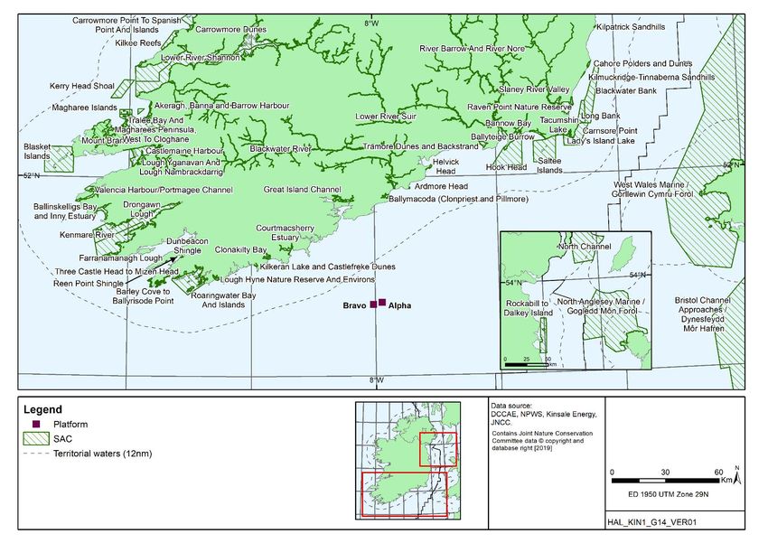
Kinsale Platform Survey:                                              PSE Kinsale Energy Limited
EIA Screening Report                                                                March 2020
                                                                                         Page ii

GLOSSARY
   Term                                           Definition
AA            Appropriate Assessment
ASCOBANS      Agreement on the Conservation of Small Cetaceans of the Baltic and North Seas
              1991
BOEM          US Bureau of Ocean Energy Management
BWI           Bird Watch Ireland
CSHAS         Celtic Sea Herring Acoustic Survey
DCCAE         Department of Communications, Climate Action and Environment
DCENR         Department of Communications, Energy and Natural Resources
EIA           Environmental Impact Assessment
EIAR          Environmental Impact Assessment Report
EPA           Environmental Protection Agency
EUNIS         European Nature Information System
HRGS          High-Resolution Geophysical Survey
IBA           Important Bird Areas
IMO           International Maritime Organisation
KA            Kinsale Alpha
KB            Kinsale Bravo
MARPOL        The International Convention for the Prevention of Pollution from Ships
MSFD          Marine Strategy Framework Directive
Natura 2000   Natura 2000 is a network of nature protection areas in the territory of the
              European Union. It is made up of Special Areas of Conservation (SACs) and
              Special Protection Areas (SPAs) designated respectively under the Habitats
              Directive and Birds Directive.
NHA/pNHA      Natural Heritage Area/proposed Natural Heritage Area
NPWS          National Parks and Wildlife Service
PAD           Petroleum Affairs Division of the Department of Communications, Climate Action and
              Environment
PAM           Passive Acoustic Monitoring
PEXA          Military Practice and Exercise Areas
PTS           Permanent Threshold Shift
RAMSAR        Intergovernmental treaty that provides the framework for the conservation and
              wise use of wetlands and their resources
SAC           Special Area of Conservation: established under the Habitats Directive
SBP           Sub-Bottom Profiler
SFPA          Sea Fisheries Protection Authority
SPA           Special Protection Area: established under the Birds Directive
TTS           Temporary Threshold Shift
UKOOA         United Kingdom Offshore Operators Association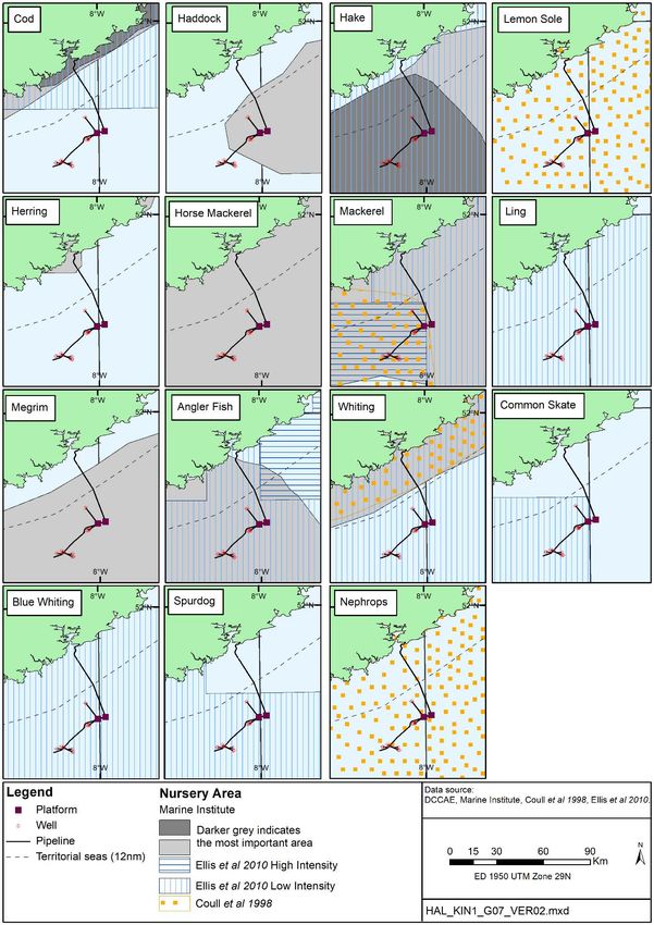
Kinsale Platform Survey:                                            PSE Kinsale Energy Limited
EIA Screening Report                                                              March 2020
                                                                                       Page 1

1          INTRODUCTION
1.1        The Applicant
PSE Kinsale Energy Limited (Kinsale Energy) is applying for consent to undertake survey
activities at the Kinsale Alpha (KA) and Bravo (KB) platforms in petroleum lease area No.1
covering Blocks 48/20, 48/25, 49/16 and 49/21 in the North Celtic Sea Basin. The platforms
are located off the coast of Co. Cork, approximately 47km and 45km from the nearest
landfall respectively (Figure 1.1).

Discovery of the Kinsale Head area gas reserves were made by Marathon Oil in 1971, and
production commenced in 1978 following the installation of the KA and KB platforms.
Subsequent discoveries were made in the Kinsale Head area including Ballycotton,
Southwest Kinsale and the Seven Heads fields and developed as subsea tie-backs to the
Kinsale Head platforms.

1.2        Background and document purpose
Kinsale Energy is preparing for the decommissioning of the Kinsale Area gas fields and
facilities which are coming to the end of their productive life, and in keeping with lease
obligations have prepared Decommissioning Plans and related Environmental Impact
Assessment Report (EIAR) and Appropriate Assessment (AA) screening reports, which have
been submitted to the Petroleum Affairs Division (PAD) of the Department of
Communications, Climate Action & Environment (DCCAE). To inform the detailed removal
procedures for the platform jackets, a survey is proposed to confirm the shallow seabed
conditions in the immediate vicinity of the platforms. The survey will include the use of
equipment (e.g. sub-bottom profiler and chirp) to detect the depth of surficial sediments and
their contact with the underlying bedrock to inform the need for any excavation around the
jacket piles during jacket removal (more detail is provided in Section 2).

1.3       Legislative background and EIA process
The development and administration of policy in relation to exploration and production of
Ireland’s petroleum resources is the responsibility of PAD within DCCAE. The Department is
also responsible for environmental regulation and monitoring of offshore developments.

There are mandatory requirements where an Environmental Impact Assessment Report
(EIAR) is to be prepared (as outlined in Annex I of the EIA Directive 2011/92/EU1), also see
Schedule 1 of the European Communities (Environmental Impact Assessment) Regulations
1989 (as amended). Additionally, provisions relating to EIA for exploratory activities relating
to oil & gas activity in Ireland are contained in the European Union (Environmental Impact
Assessment) (Petroleum Exploration) Regulations 2013, amended by the European Union
(Environmental Impact Assessment) (Petroleum Exploration) (Amendment) Regulations
2019. For projects listed in Annex II of the Directive, the approach in Ireland has been to set
certain thresholds/criteria whereby an Environmental Impact Assessment Report (EIAR)
would be prepared, and the competent authorities may request an EIAR be prepared with
reference to those criteria set out in Annex III of the Directive, if in their opinion, the
proposed activities are likely to have significant effects on the environment “by virtue, inter
alia, of their nature, size and location”. The Licensing Terms and the Rules and Procedures

1
  Amended by Directive 2014/52/EU, and transposed by The European Union (Planning and
Development) (Environmental Impact Assessment) Regulations 2018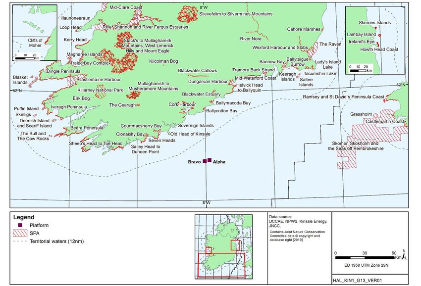
Kinsale Platform Survey:                                              PSE Kinsale Energy Limited
EIA Screening Report                                                                March 2020
                                                                                         Page 2

for Offshore Petroleum Exploration and Appraisal Operations specify various relevant
standards and provisions for the offshore industry relevant to this application.

In view of the nature of the proposed survey, it is not considered that there is a statutory
requirement to complete an EIAR. This EIA screening report has been prepared to fulfil the
requirements of the EIA Directive by providing an environmental appraisal of the potential for
direct and indirect significant effects of the proposed survey programme as outlined in
Section 2, in order to provide the relevant information to allow the Competent Authority to
make a screening decision on whether an Environmental Impact Assessment (EIA) is
required, and whether consent for the activities can be granted.

1.3.1      Other relevant legislation
Ireland is a contracting party to the Convention on the Prevention of Marine Pollution by
Dumping from Ships 1972, and to the Paris Convention on the Prevention of Marine
Pollution from Land-based Sources 1974 (the “Oslo” and “Paris” Conventions respectively,
both of which include offshore installations), and has adopted as a minimum requirement the
international standards set by PARCOM and OSPAR. Ireland has ratified the International
Convention for the Prevention of Pollution from Ships 1973 as modified by the Protocol of
1978 relating thereto (MARPOL 73/78) and implements requirements through regulations
under the Sea Pollution Act 1991 (as amended). Any vessel used in the survey campaign
would therefore be subject to relevant controls under MARPOL.

There is a range of international and national legislation aimed at protecting fauna, flora and
habitats. The UNESCO Convention on wetlands of international importance especially as
waterfowl habitat (Ramsar Convention) has been ratified by Ireland. The requirements of
EU nature conservation directives EC Council Directive 92/43/EEC on the conservation of
natural habitats and of wild fauna and flora (the “Habitats and Species Directive”); and EC
Council Directive 2009/147/EC (the “Bird Directive”) have been implemented through the
European Communities (Conservation of Wild Birds) Regulations 1985 (as amended) and
the European Communities (Birds and Natural Habitats) Regulations 2011 both under the
Wildlife Act 1976 (as amended). Ireland is also a signatory to the Agreement on the
Conservation of Small Cetaceans of the Baltic and North Seas 1991 (ASCOBANS).
ASCOBANS requires governments to undertake habitat management, conduct surveys and
research and to enforce legislation to protect small cetaceans.

Ireland is a signatory to the Espoo Convention 1991, which requires government
consideration of the potential of certain projects to have significant transboundary impact on
the environment of any neighbouring state.

1.3.2      Appropriate Assessment Screening
An Appropriate Assessment (AA) screening exercise has been undertaken to consider the
potential for likely significant effects to arise in relation to Natura 2000 sites from activities
associated with the proposed survey. The AA screening has been undertaken in keeping
with European Communities (Birds and Natural Habitats) Regulations 2011 (as amended)
and in accordance with the requirements of Directive 2009/147/EC on the conservation of
wild birds (the “Birds Directive”), and Council Directive 92/43/EEC on the conservation of
natural habitats and of wild fauna and flora (the “Habitats Directive”).

The outcome of the AA screening exercise is documented in a separate Screening for
Appropriate Assessment report, which considers the implications of the proposed survey, on
its own and in combination with other plans or projects, for European sites in view of the
conservation objectives of those sites.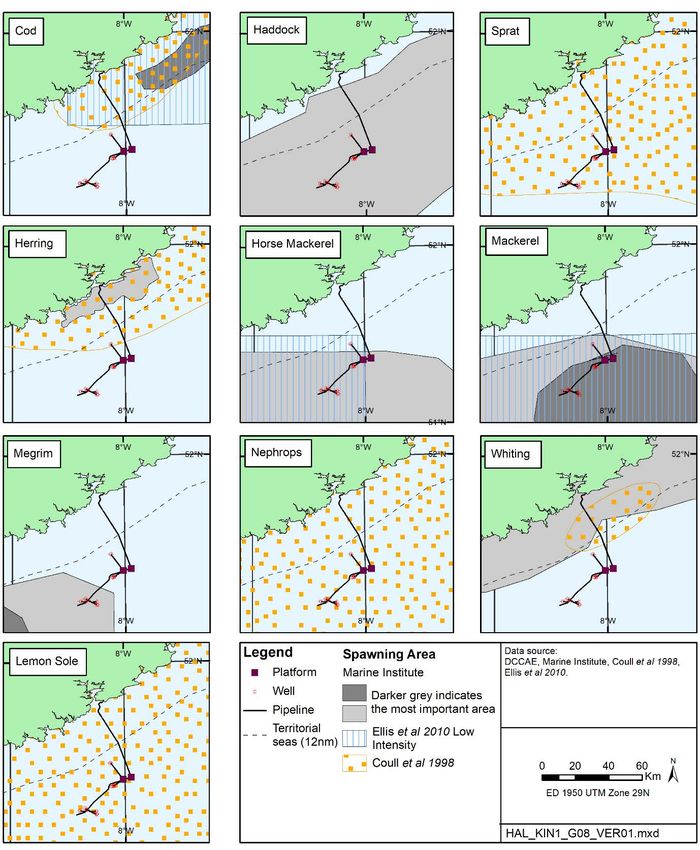
Kinsale Platform Survey:                                           PSE Kinsale Energy Limited
EIA Screening Report                                                             March 2020
                                                                                      Page 3

1.3.3      Annex IV Species Screening Assessment
In addition to the requirement to consider the potential for effects on Natura 2000 Sites
under Article 6 of the Habitats Directive (above), the Directive and transposing legislation,
the European Communities (Birds and Natural Habitats) Regulations 2011 (as amended),
requires consideration of the potential effects on species listed under Annex IV of the
Directive (termed Annex IV species). Under Article 12, Annex IV species are afforded strict
protection throughout their range, both inside and outside of designated protected areas.
The potential for interaction with Annex IV species and related effects are considered in
Section 5 of this report.

1.3.4      Pre-survey fisheries assessment
The survey programme is focussed on an area directly associated with KA and KB and
within the statutory 500m exclusion zone which surrounds the platforms, with operations
expected to be complete within one day (see Section 2). The fisheries baseline is described
in this EIA screening along with a consideration of the potential for interaction with and for
effects on fisheries. See also the separate Pre-survey Fisheries Assessment Report
prepared for this survey.
Kinsale Platform Survey:                                     PSE Kinsale Energy Limited
EIA Screening Report                                                       March 2020
                                                                                Page 4

 Figure 1.1: Location of the Kinsale Alpha and Bravo platforms in the wider Kinsale
                                        Area
Kinsale Platform Survey:                                              PSE Kinsale Energy Limited
EIA Screening Report                                                                March 2020
                                                                                         Page 5

2         PROJECT DESCRIPTION
2.1       Survey background and purpose
As noted in Section 1, Kinsale Energy is preparing for the decommissioning of the Kinsale
Area gas fields and facilities, including the Kinsale Alpha (KA) and Kinsale Bravo (KB)
platforms. Two applications have been made in relation to the decommissioning of the
Kinsale area facilities which were each accompanied by an Environmental Impact
Assessment Report and Appropriate Assessment screening2. These applications covered;
facilities preparation, well plug and abandonment, platform topsides and subsea structure
removal (application no. 1); and jacket removal (application no. 2).

As noted in the decommissioning programme for application no. 2 (see Section 3 of the
related EIAR), it is proposed that the jacket piles are cut prior to jacket removal through the
use of an internal cutting tool, or where required, cutting externally. Some excavation of
surficial seabed sediments may therefore be required to access the piles to allow external
cutting as part of jacket removal.

The surficial sediments across the Kinsale Head area are shallow, with sub-cropping chalk
present near the surface. It is proposed that a survey is undertaken in order to determine
the present depth of the surficial sediments at each platform to inform the level of any
excavation required. For the purposes of jacket lift, it is only required to determine whether
the chalk/seabed sediment contact is within 5m of the seabed.

This EIA Screening Report has been prepared to cover the survey elements only. The
jacket removal procedures have already been detailed and assessed as part of the
application no. 2 and will not be considered again here.

2.2        Survey activity and equipment
The specific equipment to be used as part of the survey is yet to be selected, but the range
of equipment which could be deployed is listed in Table 2.1, and all are considered in terms
of their potential impact in Section 4. The potential equipment includes several different
types of sub-bottom profilers (SBPs) which can provide information on the shallow geology
to depths of between a few metres to up to 100m below the seabed depending on the
specific device and sediment characteristics. The selected equipment will not differ
substantially from those listed in Table 2.1 such that the scale or nature of potential effects
will not differ from those assessed in this report.

A line plan for the survey is shown in Figure 2.1, applicable to both platforms. Around each
platform, four lines, each of approximately 120-160m length, will be surveyed at 30m off
each platform face. Equipment may be hull mounted or towed; in the case of the latter, the
equipment will first be deployed over board prior to the sailing of the survey lines. Data
collection quality will be monitored and additional lines may need to be run if required, these
will be in the same area as indicated in Figure 2.1.

2
  See: https://www.dccae.gov.ie/en-ie/natural-resources/topics/Oil-Gas-Exploration-
Production/environment/statutory-consents/ministerial-decisions/decommissioning-kinsale-head-and-
seven-heads-
facilities/Pages/Decommissioning%20Kinsale%20Head%20and%20Seven%20Heads%20Facilities.as
px and https://www.dccae.gov.ie/en-ie/natural-resources/consultations/Pages/Decommissioning-of-
certain-facilities-within-the-Kinsale-Head-Petroleum-Lease-area.aspx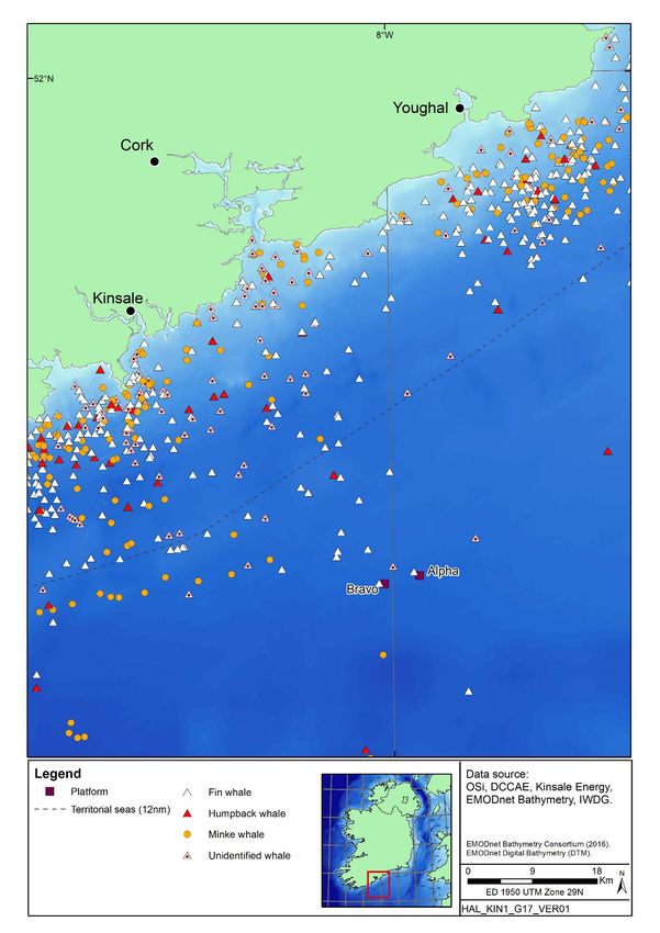
Kinsale Platform Survey:                                            PSE Kinsale Energy Limited
EIA Screening Report                                                              March 2020
                                                                                       Page 6

It is planned that the survey will take place within the period of April to September 2020, and
is expected to be complete in less than one day; operations will not take place in hours of
darkness.

                   Table 2.1: Summary of potential survey equipment
                                               Source type                Central operating
         Potential equipment
                                                                             Frequency
Knudsen Pinger SBP                      Pinger SBP                   3.5kHz/15Hz
Edgetech 3100                           Chirp SBP                    2-16kHz
Knudsen Chirp 3260                      Chirp SBP                    3.5kHz
Innomar SES2000                         Parametric/non-linear SBP    Primary: 100kHz
                                                                     Secondary: 2-22kHz
                                                                     (planned = 2kHz-10kHz)

                     Figure 2.1: Indicative survey lines for KA and KB

2.3        Vessel
The vessel to complete the survey programme has not yet been selected. For the purposes
of this assessment, a representative vessel has been assumed (e.g. RV Celtic Explorer, RV
Ocean Researcher or equivalent).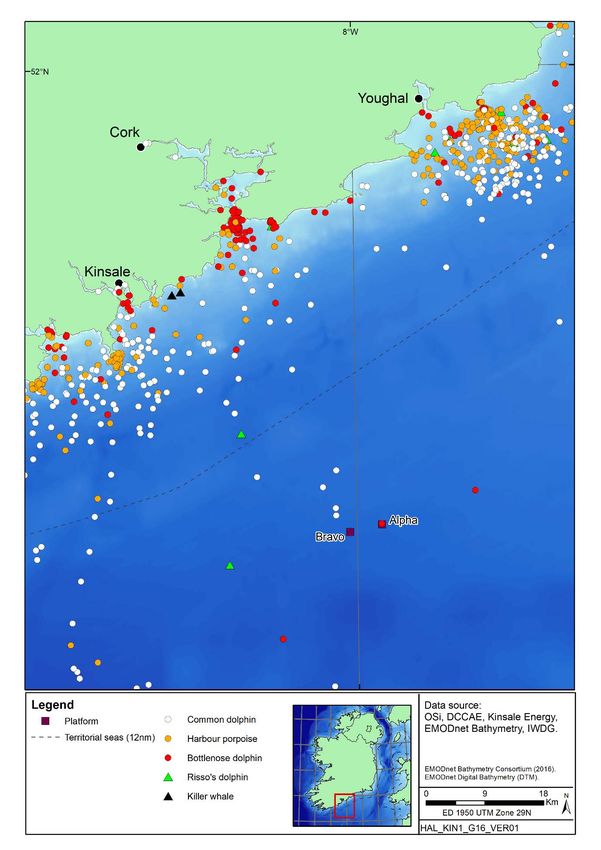
Kinsale Platform Survey:                                            PSE Kinsale Energy Limited
EIA Screening Report                                                              March 2020
                                                                                       Page 7

3          ENVIRONMENTAL CHARACTERISTICS OF THE AREA
3.1        Physical environment
3.1.1      Seabed topography, geology and sediments
The seafloor around the platforms is generally flat and has a depth of approximately 90m
(Fugro 2017) – refer to Figure 3.1. Broadscale sediments relevant to the platforms, and
across the wider Kinsale Area, variously comprise gravelly sands with outcrops of hard
substrate – the underlying Cretaceous chalk bedrock – intermittently exposed with a variable
covering of muddy sands (AquaFact 2003, 2004). Seabed samples collected in close
proximity to the KA and KB platforms (Marine Institute 2017) indicate the presence of fine to
medium sand and coarse sand to gravel respectively.

3.1.2      Climate, oceanography and hydrography
The area has a mild maritime climate with mean air temperatures varying between
approximately 6-9°C in winter to 15-16°C in summer (seasonal mean temperatures for 1981-
2010, Walsh 2012 and M5 Wexford Coast buoy observations 2004-2016, Met Eireann
website). The predominant winds over the open waters south and west of Ireland are from
the west and southwest (DCENR 2011). In the open ocean, winds of greater than 8m/s are
experienced on 70-80% of occasions in winter (October to March) and 30-35% in summer
(April to September) (Irish Coast Pilot 2006). Gales (17-20m/s) occur on approximately 20-
30% of winter days and less than 2% of summer days (Irish Coast Pilot 2006). Sea fog is
most frequent in summer, and most commonly associated with warm moist air blowing over
a relatively cold sea with winds between southeast and southwest.

Swell distributions are dominated by swells from a south-west and west direction throughout
the year, with mean significant wave heights varying between 1-1.5m in summer to 3m in
winter (data for 15 July 2016 and 15 January 2016 respectively from Marine Institute monthly
model means). Estimates of 100 year extreme metocean conditions for the Kinsale Area
indicate a significant wave height of up to 13.8m, a maximum wave height of 24.7m, and a
current speed of 1.13m/s, all from a southwesterly direction (Fugro 2015).

The general pattern of transport of water into the Celtic Sea was reviewed by Pingree & Le
Cann (1989), who identified a weak, variable but persistent flow, with typical mean speeds of
0.03m/s, moving northwards along the Brittany coast and across the mouth of the English
Channel. North of the Scilly Isles, part of this flow diverges to the west and is deflected
southwards around the south coast of Ireland, and there is generally a strong clockwise flow
around the Irish coast caused by easterly winds and the Irish Coastal Current (Fernand et al.
2006).

Surface water temperatures range from 8-10°C in winter to 15-16°C in summer, while bottom
temperatures show less variation and remain at around 8-10°C throughout the year (Connor
et al. 2006). Thermal stratification of the water column develops in spring, with a thermocline
between warm surface waters and colder deeper waters. Stratification breaks down to an
extent through autumn, although the area remains frontal throughout winter (Connor et al.
2006). Mean sea surface salinity at the Kinsale Area during the summer is 34.75‰
increasing in winter to 35.10‰, reflecting stratified and mixed conditions respectively (BODC
1998).
Kinsale Platform Survey: PSE Kinsale Energy Limited
EIA Screening Report March 2020
Page 8
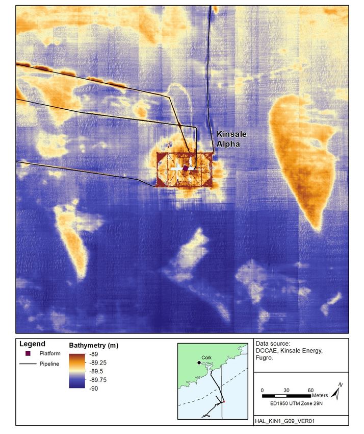
Figure 3.1: Bathymetry
a: Kinsale AlphaKinsale Platform Survey: PSE Kinsale Energy Limited
EIA Screening Report March 2020
Page 9
b: Kinsale BravoKinsale Platform Survey: PSE Kinsale Energy Limited
EIA Screening Report March 2020
Page 10
3.2 Biological environment
3.2.1 Plankton
The waters of the Celtic Sea are seasonally stratified, with greater mixing in shallower areas.
There is a heavy terrestrial influence, but also an important oceanic influence from the
Atlantic. In waters off the south of Ireland a phytoplankton bloom typically occurs every
spring, usually from mid-April, as increasing light levels and the development of the
thermocline in the stratified water column lead to an increase in phytoplankton biomass
(O’Boyle & Silke 2010). Early in the season, the phytoplankton community largely comprises
diatoms such as Thalassiosira spp. (the most frequently recorded phytoplankton taxa),
Skeletonema spp. and Chaetoceros spp., with Rhizosolenia spp. and Ceratulina spp.
increasing in abundance as the bloom develops (Pybus 1996, Johns & Wootton 2003). As
stratification increases into the summer months, opportunistic diatom species decline, and
dinoflagellate species such as Ceratium spp., Protoperidinium spp. and Dinophysis spp.
become dominant within the community. The bloom declines as summer progresses and
nutrients deplete, although occasional, smaller autumn blooms may occur. There has been
an increase in the numerical abundance of both diatoms and dinoflagellates in Irish waters
since 1998 (Marine Institute 2009).
Zooplankton communities in the Celtic Sea are dominated by copepods. Small copepods
such as Acartia spp., Oithona spp., Centropages typicus, Paracalanus spp. and
Pseudocalanus spp. are abundant in the region, along with euphausiids, cladocerans and
meroplankton such as echinoderm larvae. Amongst the calanoid copepods, the warm-water
species Calanus helgolandicus is considerably more numerous than Calanus finmarchicus
(Johns & Wootton 2003), and there has been a general movement north of C. helgolandicus
and an increase in abundance off the coast of southwest Ireland (Marine Institute 2009).
Jellyfish in the area include Rhizostoma octopus, Aurelia aurita, Chrysaora hysoscella and
Cyanea lamarckii, as well as the hydrozoans Physalia physalis (the Portuguese man-o-war)
and Velella velella (Pikesley et al. 2014). The zooplankton acts as a trophic link between the
producers (phytoplankton) and the higher predators within the ecosystem. Pelagia noctiluca,
an oceanic water-water species, may be carried into Irish waters by the shelf edge current
(Marine Institute 2009).
3.2.2 Benthos
Benthic communities are traditionally considered as two groups: infauna and epifauna. The
infauna live within the seabed sediment, and represent the most commonly surveyed and
well-known benthic community. Epifauna live on the surface of the sediment, are generally
larger than infauna, and may be sessile, such as sponges and hydroids; or mobile, such as
echinoderms and crustaceans.
The dynamic nature of the sedimentary environment of the Kinsale Head gas field which
includes the KA and KB platforms presents a range of relatively impoverished
heterogeneous benthic habitats. According to the EUNIS habitat classification, the
underlying habitat is circalittoral coarse sediment (Figure 3.2). This habitat, as with
shallower coarse sediments, can be characterized by robust infaunal polychaetes, mobile
crustaceans and bivalves (Connor et al 2004).Kinsale Platform Survey: PSE Kinsale Energy Limited
EIA Screening Report March 2020
Page 11
Figure 3.2: Predicted seabed habitatsKinsale Platform Survey: PSE Kinsale Energy Limited
EIA Screening Report March 2020
Page 12
Extensive survey work has been undertaken in the wider Kinsale Area since the discovery of
the Kinsale Head field in 1971, with the most recent survey information covering the period
2002-2017 (Aquafact 2002, 2004, Hartley Anderson 2003, 2007, Marine Institute 2010,
2011, 2017, Ecoserve 2011, Fugro 2012, Gardline 2015).
The Marine Institute (2017) pre-decommissioning survey for the Kinsale facilities sampled 31
stations with the sediments found being predominantly very coarse sand and very fine
gravel, with typically little mud (silt and clay particles) present. The benthic fauna (sampled
at 28 of the 31 stations) had a low to moderate abundance and species richness, with many
species being found across the surveyed area. Multivariate analyses of the faunal data
indicated three relatively weak clusters of stations which were geographically spread across
the survey area and with some overlapping characteristic species. The characteristic species
from the clusters included the polychaetes Spiophanes kroyeri, Lumbrineris aniara,
Mediomastus fragilis, Goniadella gracilis, Glycera lapidum, and Amphitrite cirrata, the
anemone Edwardsia sp., unidentified Nematoda and Nemertea, and the echinoderms
Amphiura filiformis and Echinocyamus pusillus. This suite of species is similar to those
recorded in previous surveys and is believed to reflect the nature of the sediments on the
area; no species indicative of contamination or organic enrichment were recorded.
All recent benthic sampling and photographic surveys in the Kinsale Area have been
consistent in reporting no indication of sensitive species or habitats which would be subject
to protection under the EU Habitats Directive (92/43/EEC) i.e. Annex I habitats. Ramboll
(2017a & b) noted the possible presence of the cold water coral Lophelia on some of the
Kinsale Area subsea infrastructure. As such colonies would be of conservation interest,
various areas with possible Lophelia were investigated by ROV during the 2017 pre-
decommissioning surveys. All colonies of possible Lophelia inspected proved to be colonies
of the serpulid polychaete Filograna implexa, a common and widespread species.
3.2.3 Fish and shellfish
The waters of southern Ireland support a diversity of fish and shellfish, including a number of
commercially valuable species. Fish assemblages tend to be closely associated with
particular physical environments, with temperature, depth and sediment type all influencing
the community composition. The southern Irish coast acts as a gateway to the wider Atlantic
from the enclosed waters of the Bristol Channel and Irish Sea. Pelagic species, including
herring (Clupea harengus), mackerel (Scomber scombrus), sprat (Sprattus sprattus) and
horse mackerel (Trachurus trachurus) are abundant in the region, and move widely between
feeding and spawning grounds (Heessen et al. 2015). The most abundant species in the
region are haddock (Melanogrammus aeglefinus), poor cod (Trisopterus minutus), Norway
pout (Trisopterus esmarkii) and whiting (Merlangius merlangus) (Marine Institute 2012),
while cod (Gadus morhua), monkfish (Lophius piscatorius), hake (Merluccius merlucius),
plaice (Pleuronectes platessa) and dab (Limanda limanda) are also abundant (Heessen et
al. 2015). The areas of sandy sediment tend to support flatfish and sandeels, while gobies,
blennies, wrasse and large gadoids are more abundant over rockier regions (Boelens et al.
1999). There are important Nephrops norvegicus (Norway lobster, scampi) grounds to the
south of Cork (Lordan et al. 2015).
The platforms are located within ICES Rectangles 31E1 and 31E2. Table 3.1 shows that the
proposed survey location overlaps or is close to known spawning grounds and nursery areas
for certain fish species. Rectangle 31E2 is within the spawning areas for herring, sprat, cod,
whiting, plaice, lemon sole and Nephrops (Coull et al. 1998), as well as haddock, megrim
(Lepidorhombus whiffiagonis) and horse mackerel (Marine Institute data – see Figure 3.3).
In addition Ellis et al. (2012) identified low spawning activity for mackerel in the area.
Mackerel, cod, whiting, lemon sole, blue whiting (Micromesistius poutassou), ling (MolvaKinsale Platform Survey: PSE Kinsale Energy Limited
EIA Screening Report March 2020
Page 13
molva), European hake, sandeels (Ammodytes spp.) and Nephrops all use the area as a
nursery area at low intensity, while the area is a high intensity nursery area for monkfish
(Ellis et al. 2012). The Marine Institute have also identified nursery grounds for herring,
haddock, megrim and horse mackerel, in addition to whiting and mackerel (Figure 3.4) The
Block is not located within any known elasmobranch spawning grounds, but was identified
within a low intensity nursery ground for spurdog (Squalus acanthias) (Ellis et al. 2012). Fish
spawning can vary temporally and spatially; spawning areas are not rigidly fixed and fish
may spawn earlier or later in the season.
A number of elasmobranch species are present in the region, including the spurdog
(Squalus acanthias) and the lesser spotted dogfish (Scyliorhinus canicula) (Marine Institute
2012). Aerial surveys from 2015-2016 for the ObSERVE project reported multiple sightings
of blue sharks in the offshore Celtic Sea region in summer (Rogan et al. 2018). Other
oceanic sharks such as thresher (Alopias vulpinus) and mako (Isurus oxyrinchus) sharks
may make occasional, seasonal visits to the region. The southern Irish coast is an area
where basking sharks are particularly common, with numerous sightings reported annually in
the summer months (Solandt & Chassin 2014).
Aerial surveys from 2015-2016 in the ObSERVE project reported ocean sunfish (Mola mola)
to be frequently observed in most offshore waters around Ireland, including off the south
coast where mot sightings were recorded in summer (Breen et al. 2017, Rogan et al. 2018).
For offshore waters of the Celtic Sea, design-based estimates of 4,625 (95% CI 2,679-
7,987) and 2,068 (95% CI 1,398-3061) were produced for the two summer surveys, and
1,044 (95% CI 606-1,799) and 73 (95% CI 14-375) for the two winter surveys (Rogan et al.
2018).
The River Lee contains populations of the diadromous species Atlantic salmon (Salmo salar)
and brown trout (Salmo trutta), which migrate from the sea to spawning locations up-river.
Salmon runs take place through the summer, with June to September particularly fruitful for
anglers.
Table 3.1: Spawning and nursery grounds in the Kinsale Area
Species Spawning grounds Nursery grounds Spawning period
Herring (a,c) January - March
Sprat (a) - May - August
Mackerel (b,c) (low) March - July
Horse mackerel (c) March - August
Blue whiting (b) - (low) -
Cod (a,b,c) (low) January - April
Haddock (c) February – May
Whiting a,b,c) (low) February - June
Hake (b,c) - (low) -
Ling (b) - (low) -
Plaice (a) - December - March
Lemon sole (a) April - September
Megrim (c) January - March
Monkfish (b,c) - (high) -Kinsale Platform Survey: PSE Kinsale Energy Limited
EIA Screening Report March 2020
Page 14
Species Spawning grounds Nursery grounds Spawning period
Spurdog (b) - (low) -
Common skate (b) - (low) -
Nephrops (a) January - December
Sources: a = Coull et al. (1998), b = Ellis et al. (2012), c = Marine Institute (2012) – spawning period
detail taken from Coull et al. (1998) and Ellis et al. (2012)
3.2.4 Marine reptiles
There are seven species of marine turtle, of which five species have been recorded in the
seas around Ireland and the UK: leatherback turtle (Dermochelys coriacea), loggerhead
turtle (Caretta caretta), Kemp’s ridley turtle (Lepidochelys kempii), green turtle (Chelonia
mydas) and hawksbill turtle (Eretmochelys imbricata). The leatherback turtle is the largest of
the marine turtles and is the only species of turtle to have developed adaptions to cold water
(Goff & Stenson 1988). The species is covered under Annex IV of the Habitats Directive
(see Section 5).
A significant majority of turtle sightings recorded in Irish waters are of the leatherback turtle
(King & Berrow 2009), which migrates into the waters of the Celtic and Irish Seas in
response to the distribution of the gelatinous zooplankton which make up their favoured diet
(Doyle et al. 2008, Fossette et al. 2010). Tagging studies show that they migrate across the
Atlantic from the eastern American mainland and the Caribbean (Hays et al. 2004, Doyle et
al. 2008). Sightings in the wider region are concentrated off the south and west of Ireland,
the southwest of England and the west coast of Wales. Most sightings occur in the summer,
peaking in August (Penrose & Gander 2016). The 2014 Celtic Sea Herring Acoustic Survey
(Cronin & Barton 2014) made four sightings of leatherback turtle, three of them
approximately 70km south of Cork Harbour, although no confirmed sightings of this species
were made in subsequent surveys (O’Donnell et al. 2016, 2017, 2018). Aerial surveys for
the ObSERVE project from 2015-2016 recorded a handful of leatherback turtle sightings at
the southern limits of Irish offshore waters in summer; none were observed in the wider
Kinsale area (Rogan et al. 2018).Kinsale Platform Survey: PSE Kinsale Energy Limited
EIA Screening Report March 2020
Page 15
Figure 3.3: Fish spawning areasKinsale Platform Survey: PSE Kinsale Energy Limited
EIA Screening Report March 2020
Page 16
Figure 3.4: Fish nursery areasKinsale Platform Survey: PSE Kinsale Energy Limited
EIA Screening Report March 2020
Page 17
3.2.5 Birds
The south coast of Ireland provides numerous habitats for seabirds, with rocky cliffs and
productive seas supporting a variety of gulls, auks, terns and shearwaters. Seabird
distribution is influenced by the distribution of prey species, which in turn is affected by a
range of physical factors. Sandeels, herring, sprat and small gadoids are among the prey
items favoured by most seabirds, and there are several spawning and nursery areas for
these in the area. Each summer, over half a million seabirds, from 24 species, search for
suitable breeding sites on the cliffs and islands of the south coast of Ireland. In addition,
over 50 species of waterbirds arrive on migration either on passage or to over-winter
(https://www.npws.ie/research-projects/animal-species/birds/wintering-waterbirds). There
are numerous SPAs (Special Protection Areas) along the coast which offer protection to
species or aggregations of seabirds and waterbirds (see Section 3.2.7). Key sources of
information on the distribution of birds in the Celtic and Irish seas include Webb et al. (1990)
and Stone et al. (1995). In addition, various surveys, including the Celtic Sea Herring
Acoustic Surveys (O’Donnell et al. 2016, 2017, 2018) and the ObSERVE programme
(Rogan et al. 2018) have recorded seabird sightings around the Kinsale Area.
Seabirds
Gulls commonly found in the Kinsale Area include herring gull (Larus argentatus), lesser
black-backed gull (Larus fuscus), great black-backed gull (Larus marinus), black-headed gull
(Chroicocephalus ridibundus) and black-legged kittiwake (Rissa tridactyla). Most gulls are
resident to the area, and are frequently recorded along the coast throughout the year. Also
resident along the south coast of Ireland are a number of auks, including guillemot (Uria
aalge), razorbill (Alca torda), Atlantic puffin (Fratercula arctica) and the black guillemot
(Cepphus grylle). Razorbill, guillemot and black guillemot are generally found in coastal
waters, although Atlantic puffin is more of an oceanic species, often found offshore off the
Porcupine Seabight, or around small islands off the south coast or in the Irish Sea. The Old
Head of Kinsale is the largest seabird colony on the south coast, between the Saltee Islands
on the southeastern point and the Bull Rock on the southwestern point. The colony it
supports has nationally important populations of black-legged kittiwake and guillemot, as
well as significant populations of herring gull, razorbill, Northern fulmar (Fulmarus glacialis)
and European shag (Phalacrocorax aristotelis) (https://www.npws.ie/research-
projects/animal-species/birds/seabirds). Great Cormorants (Phalacrocorax carbo) and
European shag also tend to remain closely associated with the coast, largely as a result of
their plumage which is less water resistant than many other seabirds. Key sites for Great
cormorants and European shags include Helvick Head, the Keeragh Islands, the Saltee
Islands and the Sovereign Islands (see Figure 3.8 for locations).
Northern Gannets (Morus bassanus) are found in large colonies, from which they forage up
to 480km offshore, along the shelf edge (DCENR 2015). Highest densities occur off the
south coast in spring and summer, with the breeding season starting in April and May. Great
Saltee Island, to the east of the Kinsale Area, is the site of one of the largest gannetries in
Ireland, with 2,446 pairs recorded there in 2004 (NPWS website).
Seasonal visitors to the area include various terns, skuas and shearwaters. Terns arrive in
the summer months at inshore areas to breed. Tern species regularly sighted in the Kinsale
area include the common tern (Sterna hirundo), the Arctic tern (Sterna paradisaea), the
Sandwich tern (Sterna sandivicensis) and the little tern (Sternula albifrons). Predatory Arctic
skuas (Stercorarius parasiticus) also tend to be summer visitors, with high densities
recorded along the Celtic Sea coast from July to September although the great skua
(Catharacta skua) is a resident which breeds in the west of Ireland (DCENR 2015), and is
occasionally recorded in the Celtic Sea. The highly pelagic petrels and shearwaters,Kinsale Platform Survey: PSE Kinsale Energy Limited
EIA Screening Report March 2020
Page 18
including the fulmar (Fulmarus glacialis), the storm petrel (Hydrobates pelagicus) and the
Manx shearwater (Puffinus puffinus), a species of which the Celtic and Irish Seas have
particularly high densities, are all most abundant in spring and summer.
Many seabirds forage considerable distances from their breeding habitats. Thaxter et al.
(2012) presented a review of representative foraging ranges during the breeding season,
based on surveys conducted over breeding colonies across Europe (including Northern
gannets on Saltee Island). Species such as Northern fulmar, Northern gannet, guillemot,
lesser black-backed gull and black-legged kittiwake, which have maximum foraging ranges
in excess of 100km, may be present in the Kinsale Area. The Celtic Sea Herring Acoustic
Surveys (O’Donnell et al. 2016, 2017, 2018) surveyed coastal and offshore waters from
Mizen Head eastwards to the Irish Sea in 2016-2018, each taking place over 2-3 weeks in
October3. The 2016 survey sighted a total of 26,429 individual seabirds representing 27
species. The most commonly recorded species were northern gannet (15,147 individuals),
guillemot (3,293), lesser black-backed gull (1,901), black-legged kittiwake (928) and razorbill
(763). The 2017 and 2018 surveys observed a similar species composition but the total
number of individuals recorded on each survey (6,939 and 3,805 respectively) was less than
in 2016.
As part of the ObSERVE programme, widespread aerial surveys of Ireland’s offshore waters
were conducted in both summer and winter in 2015 and 2016 to investigate the occurrence,
distribution and abundance of seabirds, cetaceans and other marine megafauna (Rogan et
al. 2018). Offshore waters off the south coast, including the Kinsale area, are in Stratum 4, a
large area of 62,510km2 extending from approximately 15-20km off the coast to the RoI/UK
median line and shelf waters, west to longitude 11°W. Density and abundance estimates for
the most commonly sighted species and species groups in this area are presented in Table
3.2. These indicate that gannet, Manx shearwater and petrel are consistently the most
abundant species/group in summer.
Table 3.2: Seabird density and abundance estimates for offshore waters south of
Ireland (Stratum 4) from the ObSERVE aerial surveys
1
Density; abundance (CV)
Species Summer 2015 Winter 2015-16 Summer 2016 Winter 2016-17
Gannet 0.26; 16,549 (14.6) 0.10; 6,487 (92.2) 0.34; 21,584 (16.5) 0.23; 14,169 (24.6)
Fulmar 0.12; 7,471 (42.4) 0.28; 17,225 (27.3) 0.11; 6,979 (31.4) 0.61; 38,320 (58.2)
Black-backed gull*Kinsale Platform Survey: PSE Kinsale Energy Limited
EIA Screening Report March 2020
Page 19
Waterbirds
Waterbirds, a loosely defined category including seaducks, divers, herons, waders, geese
and swans, are a major feature of the coastal habitats of Ireland, with resident, migratory
and over-wintering populations present in the area. Ireland lies on some of the major
migratory flyways of the east Atlantic, with many species not only overwintering in the area,
but also using the UK as a stopover during spring and autumn migrations. The rivers,
estuaries, bays and other coastal areas of southern Ireland are of great importance to
wintering and passage wildfowl, as well as for breeding waders and other waterbirds; several
SPA sites are designated for such features in the region (see Section 3.2.7).
3.2.6 Marine mammals
Irish waters are among the most important in Europe for cetacean species, with 25 species
having been recorded in the region, and, in 1991, the government declared Irish waters a
whale and dolphin sanctuary4. Eighteen of these species are regularly observed, while the
remaining seven might be classed as vagrant species (NPWS 2014). The combination of
shallow waters, deep oceanic areas with complex bathymetry and the productive shelf edge
provide a range of habitats and feeding opportunities.
There are several key data resources on the species composition and relative abundance of
the marine mammal fauna in the Kinsale area and wider Celtic Sea. The annual Celtic Sea
Herring Acoustic Surveys (CSHAS) cover waters off the south coast of Ireland, typically over
a three week period each October and extends from 2-3km off the coast to over 100km
offshore (e.g. O’Donnell et al. 2017). Dedicated marine mammal observers recorded
sightings when light and environmental conditions permitted; combined data from 11 years
of surveys from 2008-2018 are provided in Table 3.2. Table 3.2 also shows data extracted
from the Irish Whale and Dolphin Group’s (IWDG) Casual Cetacean Sightings database,
which includes sightings submitted by IWDG members, researchers and the general public
and validated by the IWDG (IWDG 2018). These extracted data include all sightings from
January 2008 to December 2019 (12 years) within an area spanning ~150km of the south
coast of Ireland, approximately bounded by Ardmore in the east, Spain Point in the west and
south to 51ºN (the typical offshore extent of the CSHAS) (Figures 3.5 and 3.6). The IWDG
casual sightings data are not effort corrected, and are biased towards busier and more
accessible coastal waters, and areas subject to research (e.g. Ryan et al. 2010, Whooley et
al. 2011); but provide useful information on the composition and relative abundance of
cetacean species of the area. Data from the IWDG casual database and other sources over
the period 2005-2011 were synthesised by Wall et al. (2013), which includes an assessment
of the seasonal occurrence of the most commonly sighted species.
The harbour porpoise (Phocoena phocoena), common dolphin (Delphinus delphis) and
bottlenose dolphin (Tursiops truncatus) are the most common toothed cetaceans off the
south coast of Ireland (Table 3.3), where they are sighted year-round (Table 3.4). Risso’s
dolphin (Grampus griseus) are occasionally seen in this region, primarily in summer, while a
small number of killer whale (Orcinus orca) sightings have occurred close to the coast.
Minke (Balaenoptera acutorostrata) and fin (Balaenoptera physalus) whales are the most
commonly sighted baleen whales in summer and late summer-autumn, respectively. Minke
whale are also frequently observed during late summer to autumn, albeit in apparently lower
abundance. Small numbers of humpback whales also occur in this area, with sightings
4
The Irish whale and dolphin sanctuary is not a legal entity, rather a statement of political will which
has resulted in considerable public awareness and interest towards cetaceans in Irish waters. They
are protected by national legislation (Whale Fisheries Act 1937 & 1982; Wildlife Act 1976), the EC
Habitats Directive and several international conventions.Kinsale Platform Survey: PSE Kinsale Energy Limited
EIA Screening Report March 2020
Page 20
peaking from late summer through to January. Grey (Halichoerus grypus) and harbour
(Phoca vitulina) seals are native to Irish waters and are found around the coast, although
sightings off the south coast of Ireland and in the Kinsale Area are few.
Grey and harbour seal, harbour porpoise and bottlenose dolphin are listed on Annex II of the
Habitats Directive and all cetaceans are listed on Annex IV, and their conservation status is
noted in Section 3.2.7. The indicative seasonal occurrence of cetaceans is given in Table
3.3.
Table 3.3: Cetacean sightings: (i) recorded during the annual Celtic Sea Herring
Acoustic Surveys and (ii) extracted from the IWDG Casual Cetacean Sightings
database for the Kinsale area and ~150km of adjacent coast
Celtic Sea Herring Acoustic Surveys IWDG Casual sightings
(CSHASs) 2008-2018 database 2008-2019
Species Number of years Total number of
Total number of sightings
observed sightings
(individuals)
(of a maximum of 11) (individuals)
Toothed cetaceans
Common dolphin 11 849 (12,031) 1,117 (88,867)
Harbour porpoise 8 41 (248) * 588 (2,626)
Bottlenose dolphin 6 8 (40) 202 (1,469)
Risso's dolphin 4 6 (14) 50 (390)
Killer whale 1 1 (3) 10 (26)
Pilot whale 0 0 (0) 1 (5)
Unidentified na 74 (600) 102 (1,101)
dolphin
Baleen whales
Fin whale 11 125 (222) 658 (2,530)
Minke whale 11 79 (90) 814 (4,665)
Humpback whale 6 18 (25) 245 (543)
Unidentified whale 9 62 (79) 184 (383)
Total na 1,263 (13,352) 3,971 (102,605)
Notes: See main text for a description of the two data sources. * Total harbour porpoise
sightings in the CSHASs were heavily influenced by data from the 2016 cruise report where
22 sightings, representing 191 individuals, were reported in the Celtic Deep (>100km east of
the Kinsale field); excluding 2016 data yields a total of 19 harbour porpoise sightings totalling
57 individuals.
Source: Nolan et al. (2014), O’Donnell et al. (2008, 2011, 2012, 2013, 2015, 2016, 2017,
2018) Saunders et al. (2009, 2010), IWDG (2020).Kinsale Platform Survey: PSE Kinsale Energy Limited
EIA Screening Report March 2020
Page 21
Table 3.4: Seasonal occurrence of cetaceans in the Kinsale Area
Species J F M A M J J A S O N D
Harbour porpoise 2 2 2 3 3 2 2 2 2 2 2 2
Common dolphin 2 2 2 2 2 2 2 2 1 1 1 1
Bottlenose dolphin 3 3 3 3 3 3 3 3 3 3 3 3
Risso’s dolphin - - - 4 4 3 3 3 4 4 4 -
Minke whale - - 4 3 3 3 3 3 2 2 2 4
Humpback whale 3 4 - 4 4 4 3 3 3 3 2 3
Fin whale 4 4 - - 4 4 3 3 3 2 2 3
Source: Wall et al. (2013) and S. Berrow, IWDG (pers. comm. May 2018) (see additional
references provided in text below for additional further information) Notes: Information on
seasonal abundance of cetaceans is limited, so this table should be regarded as indicative of
general trends. Abundance has been ranked from 1-4, where 1 is “very abundant” and 4 is
“low abundance”. ‘-‘ means no sightings were recorded in that month and/or abundance is
considered likely to be extremely low.
Two strata surveyed for marine mammals as part of the ObSERVE programme are relevant
to the Kinsale Area. These are Stratum 4 (as described above) and Stratum 8, which was
only surveyed in summer and winter 2016, and covered 9,506km2 of coastal waters off the
south and south-west coasts. Cetacean sightings and abundance estimates in these two
strata are summarised in Table 3.5.
For Stratum 4 (offshore), the abundance of bottlenose, common and unidentified dolphins
was considerably higher in winter. The opposite was observed for harbour porpoise, which
were by far the most abundant species recorded in Stratum 4 in summer. In Stratum 8
(coastal), both harbour porpoise and all species of dolphin showed higher abundance in
summer. Minke whale abundance was estimated to be similar across two summer and one
winter surveys, although the number of sightings was low. Within Stratum 8, minke whales
were not seen in the winter survey, but observed 20 times in summer, with sightings
clustered off the south-west coast. There were very few sightings of pinnipeds off the south
coast of Ireland, with those few being clustered in the south-west and south-east, distant to
the Kinsale Area.
For the general Kinsale Area, predicted distribution maps suggested the presence of higher
densities of harbour porpoise in summer, bottlenose dolphin in winter, and common dolphin
in winter (relative to other surveyed areas for each species). Predicted densities of minke
whale in the Kinsale Area are higher in summer than winter, with waters off the south-west
coast appearing to be of higher importance.
The ObSERVE aerial survey data provide a greater level of quantification and seasonal
information on cetaceans than was previously available for waters off the south coast of
Ireland. These new data confirm the high diversity of cetacean species off the south coast,
along with the seasonal patterns for the area which previous data had suggested.Kinsale Platform Survey: PSE Kinsale Energy Limited
EIA Screening Report March 2020
Page 22
Figure 3.5: Sightings of toothed cetaceans submitted to the IWDG Casual Cetacean
Sightings database from 2008-2019Kinsale Platform Survey: PSE Kinsale Energy Limited
EIA Screening Report March 2020
Page 23
Figure 3.6: Sightings of baleen whales submitted to the IWDG Casual Cetacean
Sightings database from 2008-2019Kinsale Platform Survey: PSE Kinsale Energy Limited
EIA Screening Report March 2020
Page 24
Table 3.5: Cetacean sighting numbers and abundance estimates for waters south of
Ireland from the ObSERVE aerial surveys in 2015 and 2016
Stratum 4 (offshore) Stratum 8 (coastal)
Species & N groups Abundance; N groups Abundance;
season (mean group density (CV) (mean group density (CV)
size) size)
Harbour porpoise
Summer 2015 41 (1.2) 14,190; 0.227 (27.4) - -
Winter 2015-16 11 (1.3) 3,752; 0.060 (41.3) - -
Summer 2016 42 (1.3) 14,196; 0.227 (37.2) 8 (1.6) 1,977; 0.208 (62.6)
Winter 2016-17 0 (na) na 3 (1) 568; 0.060 (73.2)
1
Bottlenose dolphin
Summer 2015 7 (6) 3,885; 0.062 (64.3) - -
Winter 2015-16 26 (2.9) 6,217; 0.098 (28.4) - -
Summer 2016 17 (4) 5,549; 0.088 (47.7) 39 (7.2) 11,266; 1.161 (59.9)
Winter 2016-17 91 (7.8) 58,647; 0.929 (22.3) 17 (3.8) 3,322; 0.342 (47.6)
2
Common dolphin and common/striped dolphin
Summer 2015 3 (4.5) 2,554; 0.041 (73.8) - -
Winter 2015-16 45 (8.9) 40,027; 0.639 (51.5) - -
Summer 2016 0 na 5 (5.2) 1,319; 0.139 (45.5)
Winter 2016-17 0 na 2 (4.0) 779; 0.082 (76.0)
1, 3
Risso’s dolphin
Summer 2015 0 na - -
Winter 2015-16 1 (1) 40; 0.001 (101.6) - -
Summer 2016 2 (10) 809; 0.013 (94.8) 3 (7.7) 549; 0.057 (50.9)
Winter 2016-17 0 na 0 na
1
Unidentified dolphin
Summer 2015 19 (4.9) 4,814; 0.076 (43.9) - -
Winter 2015-16 92 27,348; 0.433 (39.0) - -
Summer 2016 27 (3.3) 4,982; 0.079 (37.2) 57 (6.2) 10,047 (45.0); 1.035
Winter 2016-17 107 (7.1) 38,413; 0.608 (20.9) 28 (3.5) 4,142 (41.4); 0.427
Minke whale
Summer 2015 4 (1.0) 836 (66.6); 0.013 - -
Winter 2015-16 4 (1.0) 751 (64.8); 0.012 - -
Summer 2016 4 (1.0) 761 (63.3); 0.012 20 (1.0) 2,242 (66.1); 0.236
Winter 2016-17 0 na 0 na
1, 3
Fin whale
Summer 2015 0 na - -
Winter 2015-16 0 na - -
Summer 2016 0 na 0 na
Winter 2016-17 0 na 1 (2.0) 33 (98.4); 0.003
1
Notes. Abundance estimates for these species are uncorrected for detection probability and
2.
are therefore likely to be underestimates. Includes a small number of sightings where the
two species could not be differentiated; as Strata 4 and 8 are restricted to shelf waters andKinsale Platform Survey: PSE Kinsale Energy Limited
EIA Screening Report March 2020
Page 25
striped dolphins favour deeper waters, the values presented here can be assumed to be
3.
almost exclusively common dolphins. The abundance estimates for Risso’s dolphin and fin
whale are based on very few sightings, are highly uncertain and should be interpreted with
caution. Abundance estimates are rounded to the nearest whole number; CV rounded to 2
decimal places.
Source: Rogan et al. (2018).
Harbour porpoise
The harbour porpoise is the most abundant and widespread species occurring around the
Irish coast, commonly seen in shallow coastal waters in the summer, although surveys
suggest highest densities along the south coast occur in autumn (Marine Institute 2013).
They move further offshore in the spring; although the details of this migration are uncertain,
it may be linked to calving (DCENR 2015). Harbour porpoise are generally less often
encountered in the Celtic Sea than in the Irish Sea, although it may be that this is a result of
lower survey effort and higher sea states off the south coast (Wall et al. 2013). In both the
CSHAS and selected IWDG casual sightings data (Table 3.2), harbour porpoise are the
second most frequently sighted toothed cetacean, seen both close to shore and in offshore
waters (Figure 3.5). A comparison of the results of the broad-scale SCANS and SCANS-II
surveys (SCANS-II 2008) indicate there has been a general shift to the southwest and an
increase in the harbour porpoise population in the region over the period between the
surveys. Harbour porpoise are a designated feature within the Roaringwater Bay and Islands
SAC, 76km to the west of the Kinsale Area, with a population that has been consistently
estimated at between 150-160 individuals (Berrow et al. 2014).
Common dolphin
The common dolphin is Ireland’s most common dolphin species and it is most abundant off
the south and southwest coasts, where they are often seen in very large groups. They tend
to move east over the winter, with sightings off County Cork at their greatest between
September and January (Berrow et al. 2010). Common dolphins were, by a large margin,
the most frequently observed and numerous species during the recent CSHAS and in the
IWDG casual sightings data extract. Sightings were widely distributed throughout the waters
off the south coast of Ireland (Figure 3.5). Common dolphins typically move further offshore
in the summer and are seen in large groups, moving to inshore waters in autumn, probably
linked to the presence of large numbers of schooling pelagic fish (Marine Institute 2013).
Bottlenose dolphin
Bottlenose dolphins are present in the Celtic Sea and there is a small semi-resident
population present at Cork Harbour, where six individuals have been repeatedly sighted
(Ryan et al. 2010), with larger numbers visiting the area during the summer. The species is
more commonly seen off the west coasts of the country, with sightings peaking in summer
(Berrow et al. 2010). There are few CSHAS records of bottlenose dolphins in offshore
waters off the south coast, although there are occasional opportunistic sightings of the
species offshore, including around the Kinsale field (Wall et al. 2013, IWDG 2018). Photo-
identification data from groups of bottlenose dolphins at several locations around the coast
of Ireland have revealed movement of animals between sites separated by 130-650km over
durations of 26-760 days, providing evidence that many individuals should be considered
highly mobile and transient (O’Brien et al. 2009).Kinsale Platform Survey: PSE Kinsale Energy Limited
EIA Screening Report March 2020
Page 26
Other dolphins
Risso’s dolphin are occasionally observed in the wider area, most commonly in the summer
months and within a few kilometres of the coast (Wall et al. 2013). One Risso’s dolphin was
recorded outside Cork Harbour during the 2014 CSHAS (Nolan et al. 2014), while none were
seen off the south coast of Ireland in 2016 or 2017. A small number of killer whales have
been recorded off the south coast, primarily during summer (Wall et al. 2013). Records of
other toothed cetacean species off the south coast (i.e. white-beaked dolphin
Lagenorhynchus albirostris and long-finned pilot whale Globicephala melas) are very rare
and these species would be highly unlikely to be present in the Kinsale area.
Baleen whales
Baleen whales are sighted along the south coast of Ireland primarily from late summer
through autumn. Minke whales are observed in most months of the year, but are most
frequently seen from April to November (Berrow et al. 2010). The larger fin and humpback
whales are regularly observed in small numbers both close to the coast and further offshore,
primarily in autumn and winter when these waters are a known foraging ground (Marine
Institute 2013). Fin whales sightings peak in November (Berrow et al. 2010, Whooley et al.
2011), and they were the most frequently sighted and most numerous baleen whale in the
CSHAS data (Table 3.3). Photo-identification data were collected from whale-watching
vessels over 79 trips from 2003-2008, which resulted in the identification of 62 individual fin
whales, of which 11 were sighted across multiple years (Whooley et al. 2011). Ryan et al.
(2016) analysed several hundred humpback whale sightings from the IWDG casual
database collected from 1999-2013, revealing an annual easterly movement along the
southern coast; most sightings in the wider Kinsale Area occurred from October-December.
Grey seals
Grey seals occupy haul-outs along the Irish coast, to which they return to rest, breed and
rear young. Breeding in Ireland generally takes place between September and December
(Cronin et al. 2011). Grey seals favour exposed rocky shores, sand-bars or sea caves, with
easy access to deep water for breeding and as such, the largest colonies are found on
exposed islands off the west and southwest coasts. The closest major colony to the Kinsale
Area is at Roaringwater Bay. They are a designated feature of the Roaringwater Bay and
Islands SAC, where a permanent population of up to 150 individuals is estimated (NWPS
website). The total grey seal population of Ireland has been estimated at between 5,500 and
7,000 individuals (Ó Cadhla et al. 2008) and Duck & Morris (2013) estimated that 9% were
present along the County Cork coast. Grey seals may forage at distances of up to 100km
from their haul-out (Jones et al. 2015). Distances travelled by seals tagged on Great Blasket
Island in County Kerry by Cronin et al. (2011) were variable. It was found that larger seals
spent longer foraging at sea but travelled shorter distances, while smaller seals were found
to travel as far as the Western Isles of Scotland, utilising haul-out sites along the way. The
seals were found to spend more time at sea during the summer.
Marine usage maps for the UK and Ireland based on extensive tagging data suggest a very
low occurrence of grey seals in the Kinsale Area, with animals present in waters around the
south coast of Ireland focused off southwest Cork and southeast Wexford (Jones et al.
2015). Grey seals were observed in five of the 11 annual CSHAS from 2008-2018,
comprising 14 sightings of single seals, most of which were close to the coast (e.g.
O’Donnell et al. 2018).You can also read