Norfolk Strategic Planning Framework - Shared Spatial Objectives for a Growing County and Emerging Statement of Common Ground
←
→
Page content transcription
If your browser does not render page correctly, please read the page content below
Norfolk Strategic Planning Framework

 Shared Spatial Objectives for a Growing County
  and Emerging Statement of Common Ground

March 2018
Acknowledgements The authors would like to thank the following organisations for their support in the production of this document: Breckland District Council Broadland District Council Broads Authority Great Yarmouth Borough Council Borough Council of King’s Lynn and West Norfolk North Norfolk District Council Norwich City Council South Norfolk Council Norfolk County Council Suffolk County Council Babergh & Mid Suffolk District Councils Waveney District Council West Suffolk Council Fenland District Council East Cambridgeshire District Council South Holland District Council Natural England Environment Agency Anglian Water New Anglia Local Enterprise Partnership Greater Cambridge Greater Peterborough Local Enterprise Partnership Great Yarmouth & Waveney CCG North Norfolk CCG Norwich CCG South Norfolk CCG West Norfolk CCG Norfolk Strategic Planning Framework Page 2
Contents

ACKNOWLEDGEMENTS ............................................................................................................... 2

SUMMARY OF AGREEMENTS ...................................................................................................... 5

SECTION 1 – INTRODUCTION ...................................................................................................... 8
1.1 Purpose of this Document .......................................................................................................................... 8
1.2 Changes to the document since consultation ............................................................................................. 9
1.3 Timescale for and coverage of the Document .......................................................................................... 10

SECTION 2 – VISION AND OBJECTIVES ....................................................................................... 11
2.1 Introduction ............................................................................................................................................. 11
2.2 Proposed Spatial Vision ........................................................................................................................... 13
2.3 Proposed Shared Objectives .................................................................................................................... 13

SECTION 3 – UNDERSTANDING THE COUNTY............................................................................ 16
3.1 Administrative Boundaries....................................................................................................................... 16
3.2 Housing Markets ...................................................................................................................................... 17
3.3 Strategic Functional Economic Market Areas ........................................................................................... 19
3.4 Implications of Changing Infrastructure on Market Areas ........................................................................ 21

SECTION 4 – PROJECTIONS OF GROWTH................................................................................... 24
4.1 Population Projections ............................................................................................................................. 24
4.2 Household Projections ............................................................................................................................. 27
4.3 Employment Projections .......................................................................................................................... 27

SECTION 5 – THE ECONOMY ..................................................................................................... 29
5.1 Introduction ............................................................................................................................................. 29
5.2 Strategic Employment Sites ..................................................................................................................... 32
5.3 Key Cross-Boundary Economic Issues and Interventions .......................................................................... 34
   The role of Norwich .......................................................................................................................................... 34
   Cambridge to Norwich Technology Corridor .................................................................................................... 35
   A47 Corridor ..................................................................................................................................................... 36
   Offshore Energy Sector / Ports of Great Yarmouth & Lowestoft ..................................................................... 36
   Norfolk Coast, the Broads and the Brecks ........................................................................................................ 36
   A10 corridor ..................................................................................................................................................... 37
5.4 Strategic Principles of Economic Success .................................................................................................. 38

SECTION 6 – HOUSING .............................................................................................................. 39
6.1 Introduction ............................................................................................................................................. 39
6.2 Existing targets, supply, and delivery rates up to 2021 ............................................................................. 42
6.3 Future Housing Demand and Need 2015-2036. ........................................................................................ 43
   The Broads........................................................................................................................................................ 45
   Implications of the City Deal for Housing ......................................................................................................... 45
6.4 Type of Homes ......................................................................................................................................... 46
   Specialist types of accommodation .................................................................................................................. 47
   Elderly People................................................................................................................................................... 47

Norfolk Strategic Planning Framework                                                                                                  Page 3
Student Housing and the OAN ......................................................................................................................... 47
   Accommodation needs of Gypsies, Travellers, and other types of accommodation ....................................... 48
6.5 Capacity and Distribution ......................................................................................................................... 49
6.6 Delivering Housing Growth ...................................................................................................................... 49

SECTION 7 – INFRASTRUCTURE AND ENVIRONMENT................................................................ 51
7.1 Introduction ............................................................................................................................................. 52
7.2 Utilities .................................................................................................................................................... 53
7.3 Electricity ................................................................................................................................................. 54
7.4 Water ....................................................................................................................................................... 55
7.5 Telecoms .................................................................................................................................................. 56
   Broadband ........................................................................................................................................................ 56
   Mobile telephony ............................................................................................................................................. 58
   Coverage in Norfolk .......................................................................................................................................... 58
7.6 Social Infrastructure ................................................................................................................................. 59
   Health ............................................................................................................................................................... 59
   Education ......................................................................................................................................................... 61
7.7 Transportation ......................................................................................................................................... 62
   Improvements needed ..................................................................................................................................... 65
7.8 Flood Protection and Green Infrastructure .............................................................................................. 67
   Flood Protection ............................................................................................................................................... 67
   Green Infrastructure and the Environment ..................................................................................................... 69

SECTION 8 – NEXT STEPS........................................................................................................... 73

APPENDIX 1 – NSF CONTACTS ................................................................................................... 74

Norfolk Strategic Planning Framework                                                                                                     Page 4
Summary of Agreements
Agreement 1 - That when preparing new Local Plans which seek to identify levels of Objectively
Assessed Need for housing the Norfolk Planning Authorities will produce documents which
provide for the development needs of their areas until at least 2036.
Agreement 2 - In preparing their Local Plans the Norfolk Planning Authorities will seek to
positively contribute towards the delivery of the following vision.
‘By the middle of the 21st century Norfolk will be increasingly recognised nationally for having a
strong and vibrant economy providing high quality economic opportunities for residents in urban
and rural areas. Its settlements and key infrastructure will be physically resilient to the impacts of
climate change. The natural, built and historic environments will be enhanced through the
regeneration of settlements, safeguarding and enhancement of current assets and networks,
improving both biodiversity and the quality of life for residents. Housing needs will be met in full in
socially inclusive communities. The County will be better connected by having good transport links
to major cities in the UK and Europe and excellent digital connectivity. A good relationship between
homes and jobs will minimise the need to travel and residents will have choice about how they meet
their demand for local travel.’
Agreement 3 - By 2036, through co-operation between Local Authorities and preparation of
Development Plans, Norfolk will seek to maximise the delivery of the following objectives (in no
particular order):
• To realise the economic potential of Norfolk and its people *
• To reduce Norfolk’s greenhouse gas emissions as well as the impact from, exposure to, and
effects of climate change *
• To address housing needs in Norfolk *
• To improve the quality of life for all the population of Norfolk *
• To improve and conserve Norfolk’s rich and biodiverse environment *
[* full details of each objective are in section 2 of this document]
Agreement 4 - To produce and maintain Strategic Housing Market Assessments covering the three
contiguous and non-overlapping broad market areas of Great Yarmouth, Central Norfolk and West
Norfolk.
Agreement 5 - That Great Yarmouth and King’s Lynn and West Norfolk will each continue to
prepare separate Local Plans for their areas.
Agreement 6 - That Breckland and North Norfolk will continue to prepare separate Local Plans for
their areas whilst Broadland District Council, Norwich City Council and South Norfolk Council will
co-operate on a new Greater Norwich Local Plan that will replace the current Joint Core Strategy
and various other existing Local Plan documents in this area.
Agreement 7 - That, in view of the very distinct issues facing the Broads Authority Area, spatial
planning matters will continue to be best addressed by way of a standalone Broads Local Plan.
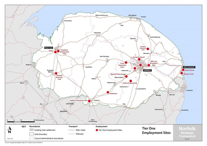
Agreement 8 - The above list of locations are the Tier One Employment sites and should be the
focus of investment to drive increasing economic development in key sectors, and protected from
loss to other uses.
Norfolk Strategic Planning Framework Page 5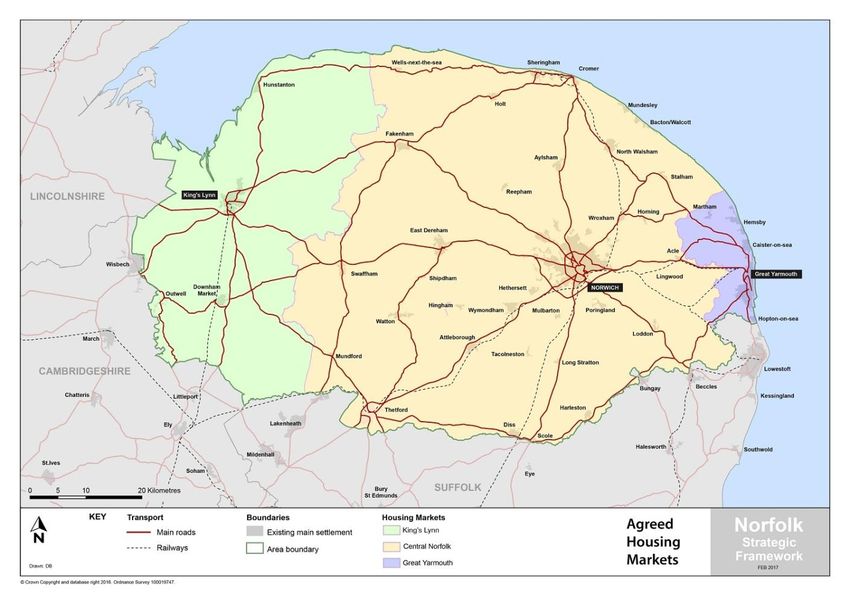
Agreement 10 - When determining their respective Local Plan housing targets each authority,
working together where desirable, will aim to deliver at least Objectively Assessed Need as
identified in the most up to date evidence (Table 8). Where this would result in unsustainable
development, agreement will be sought with other authorities, initially within the same Housing
Market Area, to ensure sufficient homes are provided to meet identified needs and demands in
the area until at least 2036.

Agreement 11 - The Broads Authority will meet its calculated portion of the wider housing need
within each of the relevant SHMAs, as far as is compatible with the protection of the Broads
landscape and special qualities.

Agreement 12 - South Norfolk, Norwich City, Broadland, North Norfolk, and Great Yarmouth
Councils will seek to include appropriate provision within their Local Plans to address the housing
needs arising from the parts of the Broads Authority area overlapping their administrative
boundaries if these cannot be met within the Broads Local Plan.

Agreement 13 - In addition to their OAN, Broadland, Norwich City, and South Norfolk Councils will
seek to deliver an additional supply of 5,228 homes42 within the Greater Norwich Local Plan to
ensure the housing needs arising from the City Deal are met in full.

Agreement 14 - The Norfolk Planning Authorities will quantify the need for, and plan to provide
for, the specialist accommodation needs of the elderly, students, gypsy and travelling Show
People, and those residing in other specialist types of accommodation and working together will
ensure that the distribution of provision responds to locally identified needs.

Agreement 15 - All Local Planning authorities will produce their Housing and Economic Land
Availability Assessments to the standard Norfolk methodology.

Agreement 16 - To minimise the risk of slow delivery over the next plan period, where it is
sustainable to do so, the following will be done:

•       Housing strategies will seek to allocate a range of different sizes of sites, where such sites
are available and would result sustainable development.

•       Clear evidence and demonstration of ability to deliver development will be required prior
to the allocation of larger sites for development.

Agreement 17 - Norfolk is identified as an area of serious water stress, the Norfolk Authorities
have agreed that when preparing Local Plans to seek to include the optional higher water
efficiency standard (110 litres/per person/per day) for residential development.

Agreement 18 - The Norfolk Authorities, Anglian Water and Essex and Suffolk Water have agreed
to provide regular and timely updates to each other on the delivery of development sites and
proposed utility projects to ensure that development is aligned with water and wastewater
infrastructure.

Agreement 19 - To maximise the speed of rollout of 5G telecommunications to Norfolk, the Local
Planning Authorities will seek to engage with the telecommunications industry to produce shared
guidance on the location of base and booster stations for the 5G network, taking into account
material planning considerations. The aim is to get this guidance agreed before the end of 2018
with it potentially being included in emerging Local Plan documents.

Norfolk Strategic Planning Framework                                             Page 6
Agreement 20 - The authorities agree to endorse Planning in Health: An Engagement Protocol
Between Local Planning Authorities61, Public Health and Health Sector Organisations in Norfolk
and undertake its commitments.

Assuming this is formally agreed it is expected that each Norfolk CCG will formally agree the
Protocol via its Governing Body, and NHS England will do via senior officer support.

Agreement 21 - The Local Planning authorities will continue to work closely with the County
Council and school providers to ensure a sufficient supply of school places and land for school
expansion or new schools, and use S106 and / or Community Infrastructure Levy funds to deliver
additional school places where appropriate. The authorities agree to continue supporting the
implementation of the County Council’s Planning Obligations Standards as a means of justifying
any S106 payments or bid for CIL funds needed to mitigate the impact of housing growth on
County Council infrastructure.

Agreement 22 - In recognition of:

a) the importance the Brecks, the Broads and the Area of Outstanding National Beauty, together
with environmental assets which lie outside of these areas, brings to the county in relation to
quality of life, health and wellbeing, economy, tourism and benefits to biodiversity;

b) the pressure that development in Norfolk could place on these assets; and

c) the importance of ecological connections between habitats

the Local Planning Authorities will work together to produce a GI Strategy for Norfolk in early 2018
which will aid Local Plans in protecting and where appropriate enhancing the relevant assets.

Agreement 23 - In recognition of the benefits gained by co-ordinating and co-operating on
strategic planning activities the signatories to this document agree to support the activities of the
Norfolk Strategic Planning Member Forum and to continue to appropriately resource joint
planning activity.

Norfolk Strategic Planning Framework                                            Page 7
Section 1 – Introduction
1.1 Purpose of this Document
Norfolk’s Local Planning Authorities (including Norfolk County Council) have a long track record of
working together to achieve shared objectives. In early 2015 they, working through its strategic
planning member forum, agreed to formally cooperate on a range of strategic cross-boundary
planning issues through the preparation of this Norfolk Strategic Planning Framework (previously
called the Norfolk Strategic Framework and referred to in this document as the NSF).

The aim of producing the framework is to:

   -   Agree shared objectives and strategic priorities to improve outcomes for Norfolk and inform
       the preparation of future Local Plans;
   -   Demonstrate compliance with the duty to co-operate and consistency with the National
       Planning Policy Framework (while recognising the latter is due to be revised shortly);
   -   Find efficiencies in the planning system through working towards the establishment of a
       shared evidence base;
   -   Influence subsequent high level plans (such as the Strategic Economic Plan); and
   -   Maximise the opportunities to secure external funding to deliver against agreed objectives.

The project has been underway since October 2015. Four working groups have been established to
pull together a shared evidence base on housing, employment, infrastructure and delivery issues.
The working groups consist of Local Authority staff assisted by other organisations including the
Environment Agency, Natural England, Anglian Water, UK Power Networks, Homes and Communities
Agency and the New Anglia Local Enterprise Partnership. Our thanks is extended to all those who
have contributed to this work which has informed this framework.

For further information on the work of the Norfolk Strategic Planning Member Forum and about the
process for preparing this strategy please see the Forum’s website:

www.norfolk.gov.uk/nsf

This document is intended to be strategic in nature. It provides only an overview of background
information and shared research. A wealth of information has been produced by the working
groups; however a decision has been made to keep this document concise and to concentrate on the
matters where there is a clear need for agreement between the Local Authorities. We acknowledge
that not all factors have been considered, but where appropriate, relevant additional information
has been highlighted. Mitigation of certain issues does not diminish their importance or value.

Details of the lead contact in each local Council on strategic planning matters are included in
Appendix 1.

Norfolk Strategic Planning Framework                                          Page 8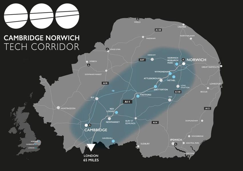
1.2 Changes to the document since consultation
A draft of this document was published for extensive public consultation over the summer of 2017.
The consultation closed on 22nd September and a significant number of representations were
received during the period. These representations have all been analysed and a considerable
number of changes to this document have been made in response. Details of the representations made
and responses to them can be seen at:

https://norfolk.citizenspace.com/consultation/norfolk-strategic-framework/

Shortly before the consultation on the NSF closed the government published consultation proposals
titled “Planning for the right homes in the right places”1. This document potentially has some
significant implications for the NSF which have been reflected in this version of the document. In
particular the government consultation proposed:

    a) a detailed methodology of a proposed standard approach to assessing housing need across
       local authority areas which had been previously proposed in the housing white paper 2as a
       measure to make the assessment of local housing need simpler, quicker and more
       transparent and therefore speed the production of local plans; and
    b) to introduce a requirement in the revised National Planning Policy Framework3 that all local
       planning authorities should produce a statement of common ground setting out cross
       boundary matters, including the housing need for the area, distribution and proposals for
       meeting any shortfalls.

Both these proposals have the potential to significantly impact upon the NSF as the draft document
already addressed issues of housing need and also did much of what the government are proposing
to introduce by introducing the requirement for producing a statement of common ground. In the
consultation document the government stressed that “The statement of common ground is not
intended to replicate any stage of the plan-making process, nor should it be an additional burden on
local planning authorities. Critically, we do not want this proposal to disrupt existing joint working
arrangements where these are effective.”4

Taking this steer from government the authorities are of the view that the NSF should effectively
become the statement of Common Ground for Norfolk and a number of amendments have been
made to the NSF so it is clear that this is the intention and to comply with the detail of what was
proposed by government in the consultation document. Clearly as the government proposals have
only been published for consultation at this stage it will be necessary to keep this decision under
review and change the NSF further during 2018 if this is deemed necessary in order to comply with
the requirements of the revised national Planning Policy Framework when it is finalised.

1
 See https://www.gov.uk/government/consultations/planning-for-the-right-homes-in-the-right-places-
consultation-proposals
2
  https://www.gov.uk/government/collections/housing-white-paper
3
  Due to be produced by Spring 2018
4
  See para 65 of the consultation document

Norfolk Strategic Planning Framework                                                Page 9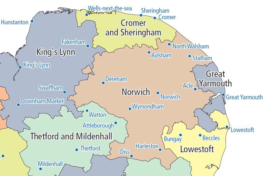
1.3 Timescale for and coverage of the Document
This document relates to the whole of Norfolk and all Norfolk authorities which include:

Breckland District Council, Broadland District Council, Broads Authority, Great Yarmouth Borough
Council, Borough Council of King’s Lynn and West Norfolk, Norwich City Council, North Norfolk
District Council, South Norfolk Council and Norfolk County Council.

All Norfolk Local Planning Authorities have agreed that in their next generation of Local Plans to plan
to a common end date of at least 2036. This is reflected in the evidence base for this framework
insofar as it seeks to provide statistical information looking ahead to this period. This is also the date
by when objectives are to be achieved. However, in parts, notably the vision, it is necessary for the
document to take a longer term view.

Agreement 1 - That when preparing new Local Plans which seek to identify levels of
Objectively Assessed Need for housing the Norfolk Planning Authorities will produce
documents which provide for the development needs of their areas until at least 2036.

Norfolk Strategic Planning Framework                                                Page 10
Section 2 – Vision and Objectives
2.1 Introduction
Norfolk is a diverse County. It covers a land area of 5,370 sq. km (2,074 sq. miles) and has a
population of 892,9005. It is a largely rural county with a relatively low population density, although
over half of the population lives in the built up areas of Norwich, Great Yarmouth and King’s Lynn
and a number of market towns6. These built up areas have a very considerable stock of historic
assets and can offer a very attractive quality of life to residents.
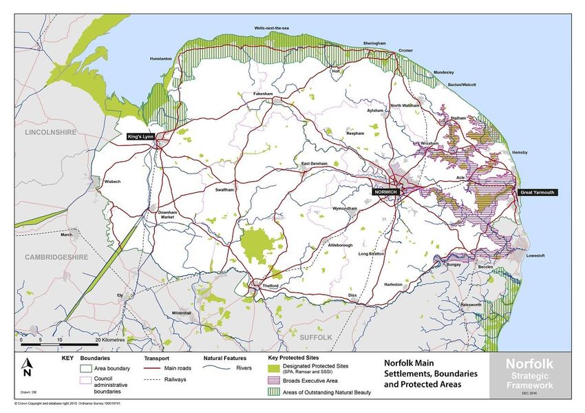
Figure 1: Map of Norfolk’s main settlement, Authority boundaries, major transport connections and protected areas.
2017
Norfolk borders Suffolk to the south, Cambridgeshire to the southwest, and Lincolnshire to the west,
and has a long coastal boundary stretching from The Wash to the south of Great Yarmouth. It
contains many environments which are highly valued for their landscape and for their biodiversity
and/or geodiversity interests. In particular, the Norfolk Coast Area of Outstanding Natural Beauty,
the Brecks and the Broads, which is a unique network of protected rivers and lakes that extends
partly into Suffolk and has the equivalent status to a National Park.
5
Mid year 2016 ONS estimate see Norfolk Insight web page http://www.norfolkinsight.org.uk/population
6
The 21 largest others centres are Attleborough, Aylsham, Cromer, Dereham, Diss, Downham Market,
Fakenham, Harleston, Holt, Hunstanton, Loddon, Long Stratton, North Walsham, Sheringham, Stalham,
Swaffham, Thetford, Wroxham/Hoveton, Wymondham, Watton, Wells-Next-The-Sea
Norfolk Strategic Planning Framework Page 11Norfolk’s economy is also diverse. It is home to a number of world class industries such as on the Norwich Research Park and the offshore energy sector in Great Yarmouth. Employment levels are growing; there is a highly skilled and versatile population with good graduate retention rates and improving links to the thriving markets of Cambridge, London and the wider South East. However, it is not without challenges, gross value added per job in the area remains below the UK average7, there are high levels of deprivation especially in urban areas and skill levels in the workforce are relatively low. The Economic Strategy (which was produced by the New Anglia Local Enterprise Partnership in 2017) identifies a number of interventions designed to significantly uplift economic performance in Norfolk. Additionally, the King’s Lynn and West Norfolk Council area is also covered by the Greater Cambridge Greater Peterborough (GCGP) Local Economic Partnership. Details of the GCGP Strategic Economic Plan can be seen online8. The document is under review. The new Cambridgeshire Combined Authority is also reviewing economic prospects in their area. Norfolk’s infrastructure is comparatively under developed compared to many other parts of the wider South and East of England. For many years Norwich was the largest city in England not connected to the motorway network by a dual carriageway. Cross county trips tended to be slow and unreliable and rail journey times from London were comparable to places in the north of England such as York and Warrington. However, the dualling of the A11 improved travel time and connectivity considerably, and recent announcements on both the A47 and the Greater Anglia rail franchise have the potential to improve this further. Norwich Airport, the busiest airport in East Anglia, offers regular flights to various destinations in the UK and Europe. Many of the key road and rail links connecting Norfolk to the rest of the UK are still in need of improvement as are many of the links within the County. The need to enhance capacity of infrastructure networks can add considerable costs and increase delays to development. Patchy mobile coverage is a continuing frustration to residents and businesses. However, the picture regarding superfast broadband coverage is rapidly improving; nearly 88% of the county’s homes and businesses can now access superfast broadband, up from 42% in 20129, and through the extension to the better broadband for Norfolk programme it is aimed to make high-speed broadband available to more than 95 per cent of Norfolk’s premises by spring 2020. Through working together and with government, businesses and residents Norfolk’s Local Authorities hope to successfully address the challenges faced and maximise the potential of the County. As a basis for guiding this shared endeavour, the following shared vision and objectives have been agreed for consultation by the Strategic Planning Member Forum. For further information on the background to this material please see the papers previously considered by the Member Forum10. 7 See NEW Anglia Lep http://www.newanglia.co.uk/wp-content/uploads/2014/03/New-Anglia-Strategic- Economic-Plan-V2.pdf 8 see http://www.gcgp.co.uk/local-growth-strategy/ 9 See Better Broadband for Norfolk Information Sheet 26 (26 May 2017) 10 th See papers for the 13 October 2016 Member Forum at www.norfolk.gov.uk/nsf Norfolk Strategic Planning Framework Page 12
2.2 Proposed Spatial Vision
Agreement 2 - In preparing their Local Plans the Norfolk Planning Authorities will seek to
positively contribute towards the delivery of the following vision.
“By the middle of the 21st century Norfolk will be increasingly recognised nationally for having a
strong and vibrant economy providing high quality economic opportunities for residents in urban
and rural areas. Its settlements and key infrastructure will be physically resilient to the impacts of
climate change. The natural, built and historic environments will be enhanced through the
regeneration of settlements, safeguarding and enhancement of current assets and networks,
improving both biodiversity and the quality of life for residents. Housing needs will be met in full in
socially inclusive communities. The County will be better connected by having good transport links
to major cities in the UK and Europe and excellent digital connectivity. A good relationship between
homes and jobs will minimise the need to travel and residents will have choice about how they meet
their demand for local travel.”
2.3 Proposed Shared Objectives
Agreement 3 - By 2036, through co-operation between Local Authorities and preparation
of Development Plans, Norfolk will seek to maximise the delivery of the following
objectives (in no particular order):
To realise the economic potential of Norfolk and its people by:
facilitating the development and infrastructure needed to support the region’s business
sectors and clusters, driving economic growth through the enhancement of productivity,
skills and education to provide widening opportunities in line with the New Anglia Local
Enterprise Partnership Economic Strategy, the Greater Cambridge Greater Peterborough
Enterprise Partnership Economic Strategy and this framework;
fully exploiting the economic opportunities offered by the economic success and global
reputation of Cambridge;
providing for job growth broadly matching increases in housing provision and improving the
alignment between the locations of workplaces and homes;
ensuring effective and sustainable digital connections and transport infrastructure between
and within Norfolk’s main settlements and across county boundaries to strengthen inward
investment; and
strengthening Norfolk’s connections to the rest of the UK, Europe and beyond by boosting
inward investment and international trade through rail, road, sea, air and digital connectivity
infrastructure.
strengthening Norfolk's competitiveness through the delivery of well-planned balanced new
developments providing access to a range of business space as well as high quality
residential, well serviced by local amenities and high quality educational facilities.
Recognising the role of our city centre and town centres as a focus for investment and
enhancing the quality of life for residents.
recognising that the long term conservation of Norfolk's natural environment and heritage is
a key element of the county's competitiveness.
Norfolk Strategic Planning Framework Page 13To reduce Norfolk’s greenhouse gas emissions as well as the impact from, exposure to, and effects of
climate change by:
locating development so as to reduce the need to travel;
effecting a major shift in travel away from car use towards public transport, walking and
cycling;
maximising the energy efficiency of development and promoting the use of renewable and
low carbon energy sources; and
managing and mitigating against the risks of adverse weather events, sea level rise and
flooding by reducing the impacts on people, property and wildlife habitats.
To address housing needs in Norfolk by:
providing for the quantity of housing growth which will support the economic prospects of
the County and address in full the identified need for new homes in line with the Economic
Strategies of New Anglia & GCGP LEPs;
ensuring that new homes built are of the right sort in terms of size, type, and tenure to
contribute positively towards addressing identified needs including for affordable homes,
homes for the elderly and students, and other groups in society requiring specialist living
accommodation;
Ensuring that new homes are served and supported by adequate social infrastructure,
including schools, libraries, fire service provision; play space and green infrastructure
provided through developer funding (e.g. through S106 agreements and/or Community
Infrastructure Levy)
contributing towards sustainable patterns of development including improving the
relationship between homes, jobs and other key day to day services;
delivering high quality, energy efficient homes in attractive communities which make a
positive contribution to the health and well-being of communities; and
ensuring that homes are delivered at the right time to address identified needs.
To improve the quality of life for all the population of Norfolk by:
ensuring new development fulfils the principles of sustainable communities, providing a
well-designed and locally distinctive living environment adequately supported by social and
green infrastructure;
promoting social cohesion by significantly improving the educational performance of our
schools, enhancing the skills of the workforce and improving access to work, services and
other facilities, especially for those who are disadvantaged;
maintaining cultural diversity while addressing the distinctive needs of each part of the
county;
ensuring all our communities are able to access excellent sporting facilities, health services
and opportunities for informal recreation;
promoting regeneration and renewal of disadvantaged areas; and
increasing community involvement in the development process at local level.
Norfolk Strategic Planning Framework Page 14To improve and conserve Norfolk’s rich and biodiverse environment by:
ensuring the protection and enhancement of Norfolk’s environmental assets, including the
built and historic environment, biodiversity, geodiversity, soils, protected landscapes, the
Broads, the Brecks and the coast;
protecting the landscape setting of our existing settlements where possible and preventing
the unplanned coalescence of settlements;
maximising the use of previously developed land within our urban areas to minimise the
need to develop previously undeveloped land;
minimising, where possible, development on the best and most versatile agricultural land;
where previously undeveloped land is developed, the environmental benefits resulting from
its development will be maximised;
protecting, maintaining and enhancing biodiversity through the conservation of existing
habitats and species, and by creating new wildlife habitats through development;
providing a coherent connected network of accessible multi-functional greenspaces;
reducing the demand for and use of water and other natural resources; and
Protecting and enhancing water, air, soil and other natural resource quality where possible.
Norfolk Strategic Planning Framework Page 15Section 3 – Understanding the County
3.1 Administrative Boundaries
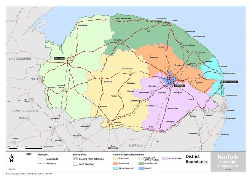
Within Norfolk there are seven separate District Council areas11 (as shown in Fig.2), each of which is
a Local Planning authority. Overlying parts of five of these areas (and also part of Waveney District
in Suffolk) is the Broads Authority which is the Local Planning Authority for its area rather than the
District Councils. The Broads Authority Executive Area (in which the Broads Authority are the
planning authority) overlays these administrative areas and is illustrated in Figure 1.
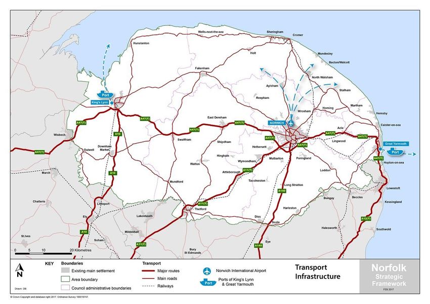
Figure 2: Map of Norfolk District boundaries and the major transport connections. 2017
In addition to the eight Local Planning Authorities the County Council are also a Local Planning
Authority responsible for minerals and waste planning as well as certain operational development
related to their functions (most notably for educational development). As County wide plans are
already in place for minerals and waste12 this framework does not address minerals and waste
matters further although further iterations of these documents will doubtless need to reflect our
11
Breckland District Council, Broadland District Council, Great Yarmouth Borough Council, King’s Lynn and
West Norfolk Borough Council, North Norfolk District Council, Norwich City Council and South Norfolk Council.
12
https://www.norfolk.gov.uk/what-we-do-and-how-we-work/policy-performance-and-partnerships/policies-
and-strategies/minerals-and-waste-planning-policies/adopted-policy-documents
Norfolk Strategic Planning Framework Page 16shared ambitions for growth. As the marine planning authority for England the MMO is responsible for preparing marine plans for English inshore and offshore waters. At its landward extent, a marine plan will apply up to the mean high water springs mark, which includes the tidal extent of any rivers. As marine plan boundaries extend up to the level of the mean high water spring tides mark, there will be an overlap with terrestrial plans which generally extend to the mean low water springs mark. Marine plans will inform and guide decision makers on development in marine and coastal areas. On 2 April 2014 the East Inshore and Offshore marine plans were published, becoming a material consideration for public authorities with decision making functions. Social, economic and environment considerations are neither determined by, nor constrained to, the administrative boundaries of the various planning authorities. Some issues affect single authorities, others are universal to the whole of the County, and across the area there are strong functional relations between places administered by neighbouring authorities. Indeed some settlements straddle the boundaries of planning authorities (Wroxham and Hoveton), as does the infrastructure which is necessary to support development. The economic geography of Norfolk is complex as it reflects a multicentric area and boundaries tend to be fuzzy. Overall the County has a relatively high level of self-containment as the vast majority of the resident workforce stay in Norfolk for work, although there are some strong functional cross county boundary linkages13. Within the County the three larger urban areas of Norwich, King’s Lynn and Great Yarmouth have a considerable influence providing jobs, retail, health care and a broad range of services and facilities as well as homes for a significant proportion of the county’s population. These three centres are located in the east, west and centre of the County and have relatively limited functional connection with one another, notwithstanding the A47 linking all three. 3.2 Housing Markets Housing Market Areas (HMAs) are defined by household demand and preferences for all types of housing, reflecting the key functional linkages between places where people live and work. In defining them, regard is given particularly to: house prices and rates of change in house prices; household migration and search patterns; and contextual data (for example travel to work area boundaries, retail and school catchment areas). They tend to represent “...the geographical area in which a substantial majority of the employed population both live and work and where those moving house without changing employment choose to stay”14. All areas need to be identified as being within a housing market although housing market areas can overlap. Norfolk HMAs can be seen in Figure 3. The Norfolk Districts and the Broads Authority have produced up to date Strategic Housing Market Assessments (SHMAs) which cover the entire County15. Within the Central Norfolk SHMA area 13 The linkages between Great Yarmouth and Lowestoft; the settlements in the Waveney Valley; and between King’s Lynn and the Fens and Cambridge being particularly important. 14 Local Housing Systems Analysis: Best Practice Guide. Edinburgh: Scottish Homes 15 See https://www.norwich.gov.uk/download/downloads/id/3993/shma_-_june_2017.pdf https://www.west-norfolk.gov.uk/download/downloads/id/1736/shma_document.pdf Norfolk Strategic Planning Framework Page 17
(comprising of Broadland District Council, Norwich City Council and South Norfolk Council) a case can
also be made for the identification of a core area based around Norwich and its immediate environs
including parts of both South Norfolk and Broadland District Councils. Outputs from the Central
Norfolk SHMA include separate conclusions in relation to this core area.

The boundaries of Housing Market Areas will rarely correspond with the administrative boundaries
of Local Authorities (Fig.3). In Norfolk there are three distinct HMAs centred on Norwich, King’s Lynn,
Yarmouth and their surrounding hinterlands. However there are some areas of the County which are
distant from any of these centres; functional links are less apparent, and the case for inclusion within
one HMA rather than another is less compelling. To ensure comprehensive coverage the Norfolk
Authorities have agreed that the boundaries of the Housing Market Areas should be co-terminus and
because housing targets will be set for each Planning Authority area the boundaries of HMAs should
be ‘snapped to’ Authority boundaries.

  Figure 3: Map of Norfolk agreed housing markets and major transport connections. 2017

Agreement 4 –To produce and maintain Strategic Housing Market Assessments covering
the three contiguous and non-overlapping broad market areas of Great Yarmouth, Central
Norfolk and West Norfolk

https://www.great-yarmouth.gov.uk/CHttpHandler.ashx?id=1241

Norfolk Strategic Planning Framework                                                      Page 18
The housing needs of the relevant parts of the Broads Authority Area are included within the SHMAs
for Central Norfolk, Great Yarmouth and Waveney. The level of need within the Broads Authority
area is specified within the Central Norfolk SHMA16.
By virtue of the methodological requirements of the definition HMAs, the Central Norfolk Housing
Market is very large and includes settlements some considerable distance apart which have little or
no functional connection. In response to this the Central Norfolk Strategic Housing Market
Assessment17 defines a core housing market area identifying the settlements with the strongest
connections to the Norwich Urban Area. This supports the decision to prepare separate Local Plans
for North Norfolk and Breckland District Councils (see below).
The above agreement was drafted in advance of the publication of the “Planning for the right homes
in the right places”. Clearly, with the possibility of a new standard methodology to assess objectively
assessed housing need whether there will be a need to produce Strategic Housing Market
Assessments in future is now open to question. However, it is clear that government still expects
local planning authorities to plan for the right mix of home types and tenures to reflect local needs
and the evidence base for such planning is only currently available from the SHMAs and is not
available from the new proposed standard methodology. Therefore it has been concluded that until
revised guidance from government is available on these matters it is best to retain agreement 4
within the NSF.
3.3 Strategic Functional Economic Market Areas
Government guidance recognises that since patterns of economic activity vary from place to place,
there is no standard approach to defining a functional economic market area. However in
recognising these areas it is possible to define them by taking account of factors including:
extent of any Local Enterprise Partnership within the area;
travel to work areas;
housing market area;
flow of goods, services and information within the local economy;
service market for consumers;
administrative area;
catchment areas of facilities providing cultural and social well-being; and
transport networks.
Boundaries of Travel to Work Areas (TTWAs) are illustrated below in Figure 4. Information on retail
matters are captured within the existing evidence base supporting Local Plans18. Both these sources
suggest that whilst Norwich is a major Regional Centre and draws trade from an extensive
catchment across Norfolk and the wider region, both King’s Lynn and Great Yarmouth retain a
16
See pages 132-134 of the Central Norfolk SHMA
https://www.norwich.gov.uk/download/downloads/id/3993/shma_-_june_2017.pdf
17
See pages 35-36 of the Central Norfolk SHMA
https://www.norwich.gov.uk/download/downloads/id/3993/shma_-_june_2017.pdf
18
See in particular www.greaternorwichgrowth.org.uk/dmsdocument/816
Norfolk Strategic Planning Framework Page 19sufficient degree of self-containment to be considered in different functional economic market areas for most purposes. It should also be noted that there are some very strong and significant cross boundary functional economic relationships. Great Yarmouth has particularly strong links with Lowestoft to the South. Within the Waveney Valley there are strong relationships between settlements on both sides of the County boundary. In the West of the County, King’s Lynn in particular has functional economic linkages to the Lincolnshire and Cambridgeshire Fens. Settlements such as King’s Lynn, Downham Market and Thetford also benefit to some extent by good access to the Cambridge economy. The position within the Central Norfolk area is again more complicated as for certain economic functions (such as higher order retail and cultural activities) the catchment area extends over the whole of Central Norfolk areas; there are far weaker connections in other areas of economic activity. In outer parts of the Central Norfolk area there is little functional connection for convenience shopping and the proportion of working residents who work in the Norwich urban area is very low19. Both Thetford and Mildenhall and Cromer and Sheringham are still regarded as being distinct Travel to Work Areas. These are illustrated below. Figure 4: Norfolk’s 2011 travel to work areas (TTWAs). Source: ONS 2015 The information available, including particularly the TTWAs and the higher retail analysis, suggests that the boundaries of strategic functional market areas are likely to be similar to the Housing Market Areas described above. Albeit, for many purposes significant sub-areas within these 19 The Central Norfolk SHMA identified the following settlements within the area of the 5 Central Norfolk Districts as having less than 10% of their resident workforce working in Norwich: Diss, Harleston, Sheringham, Swaffham, Thetford, Watton and Wells. Norfolk Strategic Planning Framework Page 20
strategic areas will exist for a number of economic functions, especially within the Central Norfolk
area.
3.4 Implications of Changing Infrastructure on Market Areas
Norfolk has benefitted from a number of significant improvements to its transport infrastructure. It
is arguable that these, and others expected to be built over the next few years will have some effect
on the functionality of the housing and economic markets. For example the dualling of the A11
(Fiveways to Thetford) was completed and opened in December 2014, significantly improving the
road connectivity between much of the County, Cambridge, the wider South East and the Midlands.
The A47/A143 link road, which opened in December 2015, now better connects Great
Yarmouth’s Enterprise Zone at Beacon Park to further growth areas. Work has also
commenced on the Norwich Northern Distributor Road, which is expected to be completed before
the end of 2018, and is a key part of the Norwich Area Transportation Strategy which also includes
considerable investment in a range of other improvements across Norwich20.
The Highways (England) Roads Investment Strategy contains a number of improvement schemes for
the A47 as part of the government’s trunk road programme from 2015 to 2020:
A47 Vauxhall and Gapton Roundabouts, Great Yarmouth
A47 Blofield to Burlingham Dualling
A47 Easton to Tuddenham Dualling
A47/A11 Thickthorn junction
Additionally further improvement to the strategic road network of the County will be delivered by
the Long Stratton bypass which is expected to be underway by 2020. The A17 is an important part of
the road network, serving longer-distance trips, and is expected to be included as part of the Major
Road Network, which we understand government will consult on before the end of the year.
In summer 2016 the Department for Transport confirmed Abelio as the operator of the new East
Anglian rail franchise, which commenced in October 2016. The new nine year franchise will deliver a
variety of improvements including the following that are of particular significance for Norfolk:
Replacement of the entire fleet of trains which will all be in service by the end of 2020;
More services and faster journeys across the network, including two 'Norwich in 90' trains each
way per day;
Norwich to Cambridge services extended to Stansted Airport every hour;
Faster services between Cambridge and London;
Work with Network Rail to implement specific schemes to drive up performance and reliability
throughout the franchise;
Increase in seats into London in the morning peak period, and an increase of more than 1,000
services per week on the franchise network; and
Various other improvements including improvements to WiFi, stations and ticketing systems.
20
See www.greaternorwichgrowth.org.uk/dmsdocument/554 for further information
Norfolk Strategic Planning Framework Page 21A priority is the improvement of the Cambridge Norwich services including half hourly frequency.
Whilst the recently delivered and announced infrastructure enhancements are welcomed and
cumulatively will assist the County in reaching its economic potential it is not considered likely they
will result in any significant change to the functional geography of the County in the immediate
future with regard to either housing or economic markets. East/West communications across the
County will remain relatively slow and lack reliability, therefore it is likely that both King’s Lynn and
Great Yarmouth will retain similar levels of self-containment in housing and economic matters as
present. The functional geography of the County will remain broadly as it is at least for the period of
the preparation of the next round of Local Plans.
In the “Planning for the right homes in the right places21” consultation document the government
proposes “that every local planning authority produce a statement of common ground over the
housing market area or other agreed geographical area where justified and appropriate”.
In the light of the objectives of the government in introducing the requirement for statements of
common ground, and the above analysis of our functional economic geography it is the view of the
Norfolk Local Planning Authorities that there is a strong case to produce a single statement of
common ground across Norfolk rather than seeking to produce three separate ones based on one
large and two small Housing Market Areas. The reasons for this are:
- The recognised desire of the government not to disrupt existing joint working arrangements
where these are effective;
- The high overall rate of self-containment of the Norfolk economy;
- The somewhat weak functional relationship between the outer areas of the Central Norfolk
Housing Market Area and its core and the similarity of the strategic issues faced by these
outer areas with the adjoining coastal and rural areas of Kings Lynn and West Norfolk and
Great Yarmouth Boroughs; and
- The way in which the Broads Authority area overlaps both the Great Yarmouth and Central
Norwich Housing Market Areas and five of the District planning authority areas which are
signatories to this Framework.
Furthermore the shared understanding of economic geography has led to a number of agreements
being reached about appropriate Local Planning areas for Norfolk.
The relative self-containment of both King’s Lynn and Great Yarmouth suggests that in practical
terms there may be problems in seeking to meet growth pressures evident in King’s Lynn and Great
Yarmouth within the central Norfolk area and vice versa. In the light of this the following agreement
has been reached.
Agreement 5 - That Great Yarmouth and King’s Lynn and West Norfolk will each continue
to prepare separate Local Plans for their areas.
21
https://www.gov.uk/government/consultations/planning-for-the-right-homes-in-the-right-places-
consultation-proposals
Norfolk Strategic Planning Framework Page 22With regard to Central Norfolk, the evidence does suggest that there may be some possibility for some of the growth pressures evident within the five Districts of Central Norfolk to be met within the different administrative areas of Central Norfolk. These five District authorities (Breckland, Broadland, North Norfolk, Norwich City and South Norfolk, along with the Broads Authority that partly overlaps 4 of their administrative areas) already co-operate closely, have a shared SHMA and are working on other joint studies. However, as noted above the Central Norfolk Housing Market Area is broad and contains places that have little relationship within one another and only a comparatively weak relationship with Norwich at the centre of the area. In the light of this the Local Authorities have reached agreement that whilst it will be necessary to closely co-operate on strategic planning matters and shared evidence it is only appropriate to seek to plan jointly over the area closer to Norwich with much stronger functional connectivity. The possible advantages of producing a single Local Plan covering all of Central Norfolk are considered to be outweighed by the delays this would cause to plan preparation and the difficulty of getting meaningful engagement over such a large area. Agreement 6 - That Breckland and North Norfolk will continue to prepare separate Local Plans for their areas whilst Broadland District Council, Norwich City Council and South Norfolk Council will co-operate on a new Greater Norwich Local Plan that will replace the current Joint Core Strategy and various other existing Local Plan documents in this area. The issue of whether it is appropriate to define any sub market areas or not will be a matter for those Plans. This approach does not preclude the possible redistribution of growth across the Central Norfolk area should this be supported by evidence and agreed by the relevant planning authorities. Furthermore, the Broads Authority Area overlaps functional housing and travel to work areas of Central Norfolk, Great Yarmouth and Lowestoft. The area clearly has a unique environment and a very distinct set of planning challenges which suggest that joint Local Planning would not be the best approach. Agreement 7 - That, in view of the very distinct issues facing the Broads Authority Area, spatial planning matters will continue to be best addressed by way of a standalone Broads Local Plan. For further information on the current Local Plans in the County and the timetable for review please see the Norfolk Compendium22. 22 See https://www.norfolk.gov.uk/-/media/norfolk/downloads/what-we-do-and-how-we-work/policy- performance-and-partnerships/policies-and-strategies/monitoring-land-use/norfolk-compendium-of-local- plans-2016.pdf Norfolk Strategic Planning Framework Page 23
You can also read