Grid connection for the proposed Redcap Nuweveld Wind Farms, Beaufort West Local Municipality, Central Karoo District Municipality, Western Cape ...
←
→
Page content transcription
If your browser does not render page correctly, please read the page content below

Palaeontological heritage assessment: desktop & field-based report

Grid connection for the proposed Redcap Nuweveld Wind Farms, Beaufort
West Local Municipality, Central Karoo District Municipality, Western Cape
John E. Almond
Natura Viva cc
PO Box 12410 Mill Street
CAPE TOWN 8010
naturaviva@universe.co.za

April 2021

EXECUTIVE SUMMARY

Red Cap Nuweveld North (Pty) Ltd, Hout Bay, is proposing to construct either a 132 kV OR a 400 kV
grid connection ≤105 km long in length between three proposed Nuweveld windfarms, to be situated c.
30 km south of Loxton, and the existing Eskom Droërivier Substation which is located c. 4 km southwest
of Beaufort West. The Nuweveld gridline corridor is underlain by continental sediments of the Teekloof
Formation (Lower Beaufort Group, Karoo Supergroup) of Middle to Late Permian age that were
deposited in a range of fluvial and shallow lacustrine settings in the main Karoo Basin. The Teekloof
beds are assigned to five stratigraphic subunits (members) of the Teekloof Formation, viz. the Poortjie,
Hoedemaker, Oukloof, Steenkampsvlakte and Javanerskop Members. They are associated with a
succession of four or five fossil assemblage zones (AZs), viz. the Tapinocephalus, Pristerognathus,
Tropidostoma, Cistecephalus and Daptocephalus AZs, that are largely defined on the basis of their
distinctive vertebrate faunas.
Dense fossil concentrations of small-bodied dicynodonts (herbivorous “mammal-like reptiles”) are
recorded from riverine exposures of the Poortjie and Hoedemaker Members within the gridline corridor
where this crosses the Nuweveld Wind Farm project area (e.g. on Annex Bultfontein 17, Gert
Adriaanskraal (Rocklands) RE/18). Elsewhere within the corridor, away from main drainage lines, the
potentially-fossiliferous mudrocks of the Teekloof Formation are often poorly-exposed due to extensive
cover by Late Caenozoic superficial deposits (alluvium, colluvium, surfaced gravels, soils, calcretes etc).
More resistant-weathering sandstone facies are usually fossil-poor, although locally abundant bone
fragments and teeth as well as transported woody plant stems occur within channel breccio-
congloerates of the Poortjie Member. A low palaeontological sensitivity is associated with low-relief
gridline sectors located between the WEF project area and the Nuweveldberge as well as in the
piedmont zone along the foot of the Nuweveld Escarpment near Beaufort West. Major dolerite intrusions
underlie more mountainous portions of the corridor, such as the Harpuisberg, Rooiberg and the
Nuweveldberge / Great Escarpment. The dolerites are unfossiliferous while baking and secondary
mineralisation of the adjacent sedimentary country rocks has often compromised fossil preservation.

    John E. Almond (2021)                          1                             Natura Viva cc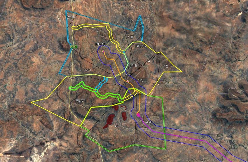
Palaeontological heritage assessment: desktop & field-based report

Despite poor bedrock exposure levels within the majority of the gridline corridor, available databases of
Karoo palaeontology (e.g. Nicolas, 2007) record a high density of vertebrate fossil sites between
Beaufort West and Loxton. It is highly likely that unrecorded, scientifically-valuable vertebrates and
other fossil remains (e.g. petrified wood and other plants, trace fossils such as tetrapod and invertebrate
burrows) are widely present within the gridline corridor, especially in areas with good hillslope and
riverine mudrock exposures. These possible unrecorded sites can only be located and documented
through further palaeontological fieldwork. Nevertheless, the methodology employed here, combining
desktop and reconnaissance-level field data, is considered to be sufficient to adequately assess
potential impacts on palaeontological heritage resources as well as to make realistic recommendations
for potential mitigation measures in the pre-construction phase. Most high-density fossil sites are likely
to occur along drainage lines and will be protected within the associated environmental buffer zones.
No palaeontological No-Go areas have been identified or defined within the Nuweveld gridline corridor.
Potential negative impacts on palaeontological heritage within outcrop areas of sedimentary bedrocks
have been reduced to a considerable extent through Screening Phase and Pre-Application Scoping
Phase palaeontological exercises that informed the current project layout (cf Almond 2019a, 2020a-d
and Site Verification Report in Appendix 3).
Based on the combined desktop and field-based study, and adopting a precautionary approach
regarding unrecorded fossil sites, the palaeontological impact significances of the 132 kV and 400 kV
Nuweveld gridlines are separately assessed as MODERATE (-ve) before mitigation. Anticipated impact
significance falls to MINOR (-ve) following implementation of the recommended mitigation measures.
These measures include:
   1. A pre-construction walkdown of the gridline alignment and project footprint by a suitably qualified
      palaeontological specialist, focusing primarily on sectors of inferred high palaeontological
      sensitivity, with recommendations on micrositing of the gridline infrastructure, if required and
      possible.
   2. Avoidance during construction of any very sensitive areas with a high density of in situ fossils
      mapped following the pre-construction walkdown.
   3. Professional palaeontological recording and sampling / collection of valuable fossils within the
      project footprint.
   4. If necessary, further pre-construction or construction phase monitoring and mitigation of bedrock
      excavations by a professional palaeontologist and the ECO, to be specified following the
      walkdown survey.
   5. Application of Chance Fossil Finds Protocol by the ECO and palaeontological specialist during
      the construction phase (See Appendix 2).
Applying the precautionary principle, a moderate (negative) rating for pre-mitigation cumulative impacts
is suggested for the Nuweveld 132 kV / 400 kV gridline in the context of (1) other transmission line
developments in the region as well as (2) the three proposed Nuweveld WEFs near Loxton (cf Almond
2020a-c). With appropriate mitigation of all projects that are approved, the cumulative impact
significance can be mitigated down to minor (-ve).
It is likely that most or all scientifically-valuable fossil sites recorded within the gridline and service /
access road footprints can be mitigated through professional recording and collection of fossil material
in the pre-construction / construction phase. Re-routing of the gridline or micrositing of individual pylons
is unlikely to be necessary, except in exceptional circumstances (e.g. high concentration of well-
preserved in situ vertebrate fossil remains within the original footprint). The palaeontological specialist
responsible for palaeontological mitigation would require a Fossil Collection Permit from Heritage
Western Cape. Following the walk-down a Phase 2 palaeontological assessment report as well as a
Fossil Collection Report must be submitted by the responsible palaeontologist to Heritage Western
Cape.

    John E. Almond (2021)                           2                              Natura Viva cc
Palaeontological heritage assessment: desktop & field-based report

Provided that the mitigation recommendations listed above are incorporated into the Environmental
Management Programme for the development and are fully implemented, there are no objections on
palaeontological heritage grounds to the authorisation of either a 132 kV OR a 400 kV gridline within
the corridor currently under consideration. In addition, the preferred alignment is found to be acceptable
within the refined corridor. Overall, the corridor does not present a fatal flaw for the routing of a lin.
Should the line routing change, the specialist would need to reconsider the alignment during micro siting
but would generally be comfortable with a change, as long as it remains within the corridor assessed.

    John E. Almond (2021)                          3                             Natura Viva cc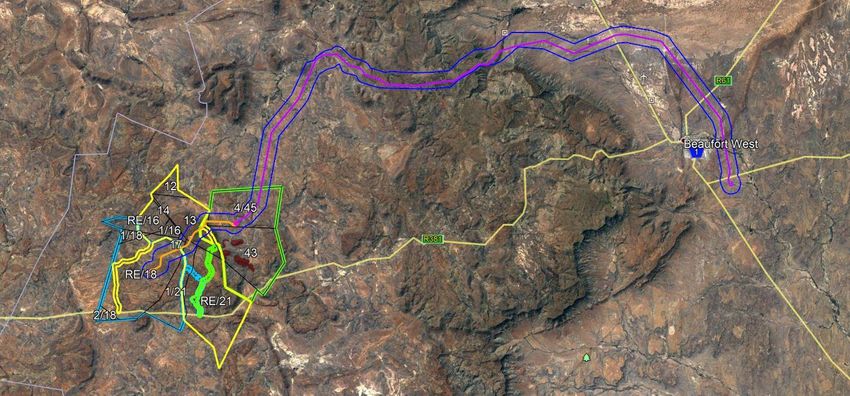
Palaeontological heritage assessment: desktop & field-based report

                 Index to components of this palaeontological specialist report

Regulation GNR 326 of 4 December 2014, as amended 7 April 2017, Appendix 6                       Report
                                                                                                 Section
(a) details of the specialist who prepared the report; and the expertise of that specialist
to compile a specialist report including a curriculum vitae;                                         12
(b) a declaration that the specialist is independent in a form as may be specified by the
                                                                                                     12
competent authority;
(c) an indication of the scope of, and the purpose for which, the report was prepared;                1
(cA) an indication of the quality and age of base data used for the specialist report;                2
(cB) a description of existing impacts on the site, cumulative impacts of the proposed
                                                                                                      8
development and levels of acceptable change;
(d) the duration, date and season of the site investigation and the relevance of the
                                                                                                      2
season to the outcome of the assessment;
(e) a description of the methodology adopted in preparing the report or carrying out the
                                                                                                      2
specialised process inclusive of equipment and modelling used;
(f) details of an assessment of the specific identified sensitivity of the site related to the
proposed activity or activities and its associated structures and infrastructure, inclusive        5&6
of a site plan identifying site alternatives;
(g) an identification of any areas to be avoided, including buffers;                                 n/a
(h) a map superimposing the activity including the associated structures and
                                                                                                   Not
infrastructure on the environmental sensitivities of the site including areas to be
                                                                                                 possible*
avoided, including buffers;
(i) a description of any assumptions made and any uncertainties or gaps in knowledge;                 3
(j) a description of the findings and potential implications of such findings on the impact
of the proposed activity, including identified alternatives on the environment, or                 7&8
activities;
(k) any mitigation measures for inclusion in the EMPr;                                             8&9
(l) any conditions for inclusion in the environmental authorisation;                                9
(m) any monitoring requirements for inclusion in the EMPr or environmental
                                                                                                      9
authorisation;
(n) a reasoned opinion—
i. as to whether the proposed activity, activities or portions thereof should be
authorised;
iA. Regarding the acceptability of the proposed activity or activities; and
                                                                                                      9
ii. if the opinion is that the proposed activity, activities or portions thereof should be
authorised, any avoidance, management and mitigation measures that should be
included in the EMPr or Environmental Authorization, and where applicable, the closure
plan;
(o) a summary and copies of any comments received during any consultation process
                                                                                                     n/a
and where applicable all responses thereto; and
(p) any other information requested by the competent authority                                       n/a
Where a government notice gazetted by the Minister provides for any protocol or                  Governme
minimum information requirement to be applied to a specialist report, the requirements            nt Notice
as indicated in such notice will apply.                                                           No. 320
                                                                                                  has been
                                                                                                  gazetted,
                                                                                                     and
                                                                                                 therefore a
                                                                                                     site
                                                                                                 verification
                                                                                                    report
                                                                                                   aligned

  John E. Almond (2021)                            4                               Natura Viva cc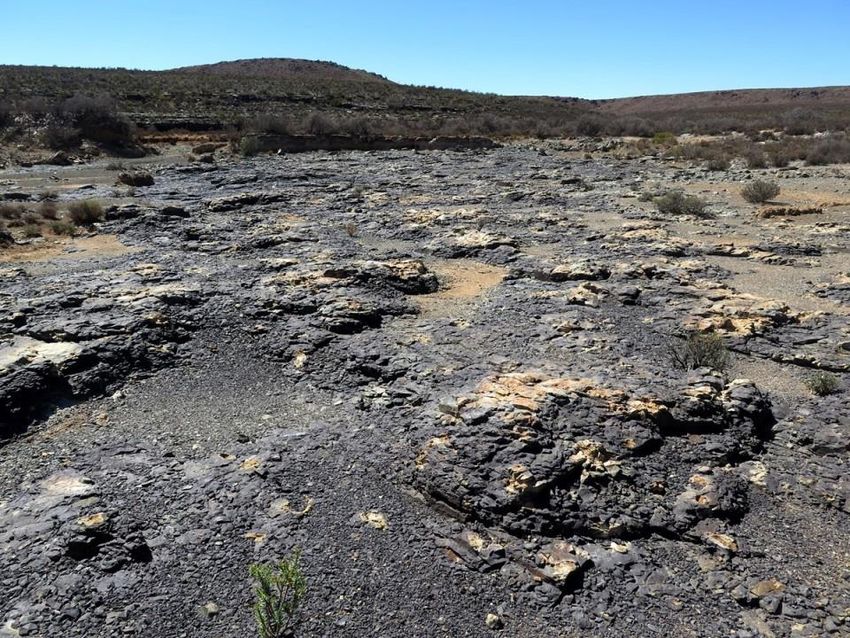
Palaeontological heritage assessment: desktop & field-based report

                                                                                       with the
                                                                                     requiremen
                                                                                        ts has
                                                                                         been
                                                                                     included in
                                                                                      this report
                                                                                      (Appendix
                                                                                           3)

•   See Section 8.2. The study area is too large to delimit palaeontological sensitivities on
    the ground during the field scoping phase. Experience shows that they are not well
    shown-up by satellite imagery. They will need to be defined and assessed during the
    walk-down phase, once the powerline route has been specified”

John E. Almond (2021)                        5                            Natura Viva cc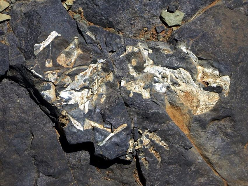
Palaeontological heritage assessment: desktop & field-based report

1.   PROJECT OUTLINE & BRIEF
The company Red Cap Nuweveld North (Pty) Ltd (Red Cap), Hout Bay, is proposing to develop up to
three adjoining wind farms (WEFs) - the Nuweveld North Wind Farm, Nuweveld West Wind Farm and
Nuweveld East Wind Farm - on a site in the Beaufort West Local Municipality, Central Karoo District
Municipality, Western Cape. The wind farms will be located approximately 65 km north of Beaufort West
and approximately 30 km south of Loxton and will be ±32,000 ha in total extent. The project proposal
includes the construction of an approximately ~120 km long 132 kV or 400 kV gridline which will connect
the three proposed wind farms to the existing Eskom Droërivier Substation situated approximately 4 km
southwest of Beaufort West (Fig. 1).
The main infrastructural components of the proposed Nuweveld gridline are as follows (See Table 1 for
further details):
•    132kV on-site powerlines connecting the three Nuweveld wind farm on-site substations and their
     associated switching stations to a centralised collector switching/ substation;
•    A ≤105 km long, 132 kV transmission line (with monopole pylons) OR a 400 kV transmission line
     (with lattice pylons) between the Nuweveld WEF switching / collector substation to the existing
     Eskom Droërivier Substation;
•    Access and service roads. Existing roads or new wind farm roads will be used within the WEF project
     area. Elsewhere it may be necessary to construct new access road sections of ≤ 6 m width from
     existing roads to the powerline servitude. The new service road (jeep track) will not exceed 4
     meters in width and will run beneath the grid line for the most part, except where short detours are
     required to obviate challenges such as steep slopes, water courses and environmentally sensitive
     areas.

The present combined desktop and field-based palaeontological heritage report (PIA) provides a
reconnaissance-level impact assessment of a 3 km to 11 km wide corridor between the combined
Nuweveld WEF site and Beaufort West within which the gridline will be sited (Orange polygon in Fig. 1).
It is noted that Red Cap is applying for authorisation of the entire corridor depicted in Figure 1 for the
purposes of the proposed new gridline development. This combined desktop and field-based PIA report
will contribute to the consolidated Heritage Impact Assessment (HIA) for the Nuweveld gridline project
which is being compiled by ASHA (Contact details: Dr Jayson Orton ASHA, 40 Brassie Street, Lakeside,
7945. E-mail: jayson@asha-consulting.co.za. Tel: 021 783 0557. Cell: 083 272 3225.). The HIA will in
turn form a component of the Basic Assessment (BA) for this development that is being co-ordinated by
Aurecon South Africa (Pty) Ltd, (Contact details: Mr Patrick Killick. Aurecon South Africa (Pty) Ltd. 65
York Street, George, 6530. Tel: +27 44 8055432. Fax:                       +27 44 8055454. E-Mail:
Patrick.Killick@aurecongroup.com).

     John E. Almond (2021)                         6                             Natura Viva cc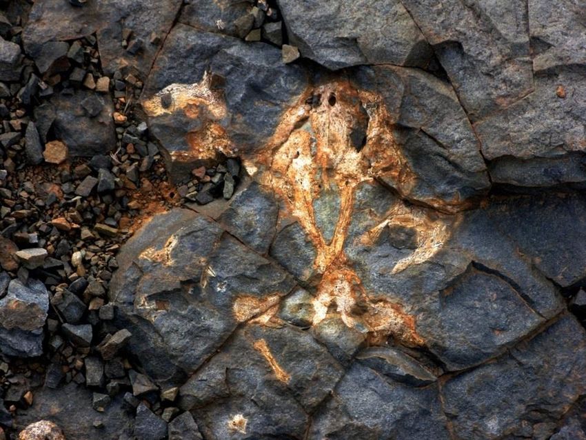
Palaeontological heritage assessment: desktop & field-based report

Table 1: Tabulated summary of infrastructural components of the proposed Nuweveld gridline
(Table provided by Aurecon).

     Project                 Specifications                                                                  Approximate
     Components                                                                                              Disturbance
     Description                                                                                             areas (WCS)
     Switching                                                                                               3.4ha
                             •    Each wind farm will have a Switching Station yard of 150m x 75m
     stations (x3)
                                  located next to the Wind Farm Substation. The Switching Station will
                                  consist of a Switchgear building and High Voltage Gantry.
                             •    The switching stations form part of the Gridline infrastructure and will
                                  be handed to Eskom in the operations phase (i.e. becoming part of the
                                  National Grid)
     132kV collector                                                                                         0.5ha
                             •    Up to approximately ≤15km of overhead 132kV high voltage monopole
     transmission
     lines                        pylon powerline is required to link the switching stations (x3) to the
                                  Collector switching station/substation. The pylons on average will be
                                  about 260m apart (estimate 65 pylons x 80m2= 0.5ha)
     Collector                                                                                               12.0ha
                             •    132kV scenario: 150m x 150m - 132kV collector switching station with
     switching
     station/substation           collector & switchgear building and High Voltage gantry (2.25ha)
                             •    400kV scenario: 300m x 400m – 400kV collector substation with
                                  collector & switchgear building and High Voltage gantry (12ha)
     132/400kV                                                                                               3.5ha
                             •    132kV scenario: Up to approximately ≤105km of overhead 132kV
     Gridline
                                  overhead powerline (440 x 80sqm = 3.5ha):
                                 o Monopole spans, without stays, are on average 260m apart
                                 o Triple pole (‘twin tern’) spans for valleys can be up to 800m apart
                                 o Pylon type and span distance is determined by topography but the
                                    majority will be the single monopole structures

                             • Up to approximately 105km of 400kV overhead powerline (estimate 290
                               pylons X 100sqm = 2.9ha):
                                o Cross-rope suspension spans, with stays, are on average 400m in
                                    length
                                o Self-supporting suspension spans, without stays, are on average
                                    400m in length
                                o Pylon type and span distance is determined by topography but the
                                    majority will be the cross-rope suspension structures
     Temporary
                         • Temporary laydown areas will be identified along the power line route,
     laydown, staging                                                                                        5ha
     and yards areas         with the main equipment and construction yards being based in one of
     and access              the surrounding towns or at the wind farm site camp & laydown areas.
     roads/tracks        •   Existing access roads and tracks (upgraded to ± 2-4m wide where
     required for the        needed) will be used as far as possible and new access tracks would             56ha
     construction /          be created where needed – these would be 2-4m wide (wider than 2m
     decommissioning         when side drains are needed or due to the topography).
     phase
     Total disturbance footprint (WCS)                                                                       81ha

    John E. Almond (2021)                                    7                                       Natura Viva cc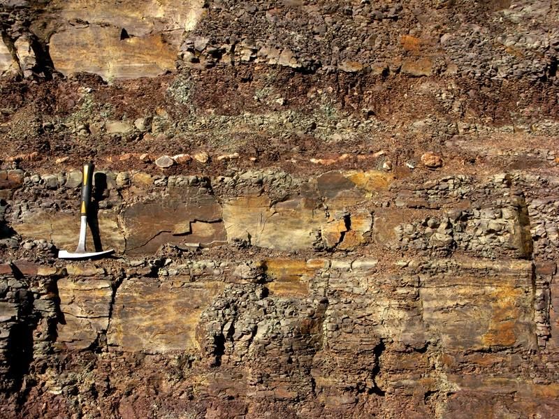
Palaeontological heritage assessment: desktop & field-based report

                                                                                                                                    N
                                                                            4
                                                               3                                              5
                                             2

                                         1

                                                                                                                         20km

Figure 1: Google Earth© satellite image showing the study corridor (outlined in blue) for the proposed 132 / 400 kV gridline between the
three adjoining Red Cap Nuweveld Wind Farms near Loxton (yellow, green and blue polygons) and the existing Droërivier Substation (red
triangle) on the western outskirts of Beaufort West, Western Cape. The five topographically-defined gridline sectors discussed in the text
are also indicated in orange.

    John E. Almond (2021)                     8                           Natura Viva cc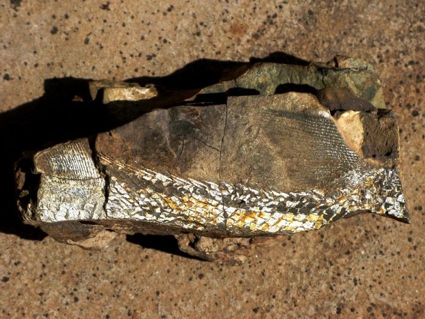
Palaeontological heritage assessment: desktop & field-based report

2.   PALAEONTOLOGICAL STUDY METHODOLOGY
This combined desktop and field-based palaeontological heritage report provides a reconnaissance-
level survey and assessment of the observed or inferred palaeontological heritage within the Nuweveld
gridline corridor, with recommendations for further specialist palaeontological studies and mitigation
where these are considered necessary. The report is based on:
     (1) a desktop review of the relevant scientific literature, including academic studies (e.g. Smith
         1993b) and previous palaeontological impact assessments in the wide Beaufort West area (e.g.
         Almond 2008, 2006, 2010a-c, 2011a-b, 2014, 2015, 2018, Durand 2017, Rubidge & Abdala
         2008);
     (2) published topographical and geological maps and accompanying sheet explanations (1: 250 000
         Sheets 3222 Beaufort West and 3122 Victoria West with explanations by Johnson & Keyser
         1979, Le Roux & Keyser 1988 respectively);
     (3) Google Earth© and other satellite imagery of the project area;
     (4) a 16-day combined field study of the consolidated Nuweveld wind farm and associated gridline
         study areas by the author and an experienced palaeontological field assistant, including the
         former western (R381 / Molteno Pass) and current eastern (DR2311 / De Jagers Pass) grid
         corridors (16 to 19 March 2019, 28 to 31 March 2019 and 13 to 20 September 2019). Note that
         the arid environment and low vegetative cover are such that the seasons do not affect the site
         work;
     (5) a palaeontological heritage gridline screening input for Red Cap centred on the western grid
         corridor option (subsequently screened out) as well as a subsequent Pre-Application Scoping
         Phase palaeontological heritage screening report (Almond 2020d) covering the great majority of
         the eastern grid corridor that is currently proposed;
     (6) the author’s extensive field experience with the formations concerned and their palaeontological
         heritage (cf Almond & Pether 2008); as well as
     (7) Consultation with palaeontologist colleagues, notably Prof. R. Smith of Wits University (cf
         benchmark papers by Smith 1993a, 1993b).
In preparing a palaeontological desktop study, the potentially fossiliferous rock units (groups, formations,
etc.) represented within the study area are determined from geological maps and satellite images. The
known fossil heritage within each rock unit is inventoried from the published scientific literature, previous
palaeontological impact studies in the same region, and the author’s field experience (consultation with
professional colleagues as well as examination of institutional fossil collections may play a role here, or
later following field assessment during the compilation of the final report). This data is then used to
assess the palaeontological sensitivity of each rock unit to development; provisional tabulations of
palaeontological sensitivity of all formations in the Western Cape have already been compiled by J.
Almond and colleagues (e.g. Almond & Pether 2008) and are shown on the palaeosensitivity map on
the SAHRIS (South African Heritage Resources Information System) website. The likely impact of the
proposed development on local fossil heritage is then determined on the basis of (1) the palaeontological
sensitivity of the rock units concerned and (2) the nature and scale of the development itself, most
notably the extent of fresh bedrock excavation and ground clearance envisaged. When rock units of
moderate to high palaeontological sensitivity are present within the development footprint, a field
assessment study by a professional palaeontologist is usually warranted.

     John E. Almond (2021)                          9                              Natura Viva cc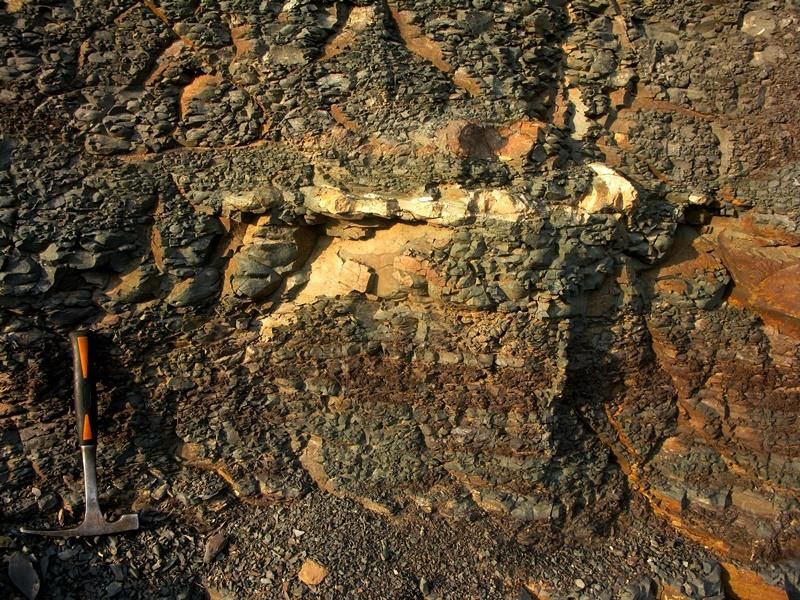
Palaeontological heritage assessment: desktop & field-based report

The focus of palaeontological field assessment is not simply to survey the development footprint or even
the development area as a whole (e.g. farms or other parcels of land concerned in the development).
Rather, the palaeontologist seeks to assess or predict the diversity, density and distribution of fossils
within and beneath the study area, as well as their heritage or scientific interest. This is primarily
achieved through a careful field examination of one or more representative exposures of all the
sedimentary rock units present (N.B. Metamorphic and igneous rocks rarely contain fossils). The best
rock exposures are generally those that are easily accessible, extensive, fresh (i.e. unweathered) and
include a large fraction of the stratigraphic unit concerned (e.g. formation). These exposures may be
natural or artificial and include, for example, rocky outcrops in stream or river banks, cliffs, quarries,
dams, dongas, open building excavations or road and railway cuttings. Uncemented superficial deposits,
such as alluvium, scree or wind-blown sands, may occasionally contain fossils and should also be
included in the field study where they are well-represented in the study area. It is normal practice for
impact palaeontologists to collect representative, well-localised (e.g. GPS and stratigraphic data)
samples of fossil material during field assessment studies. In order to do so, a fossil collection permit
from Heritage Western Cape (HWC) is required and all fossil material collected must be properly curated
within an approved repository (usually a museum or university collection).
Note that while fossil localities recorded during field work within the study area itself are obviously highly
relevant, most fossil heritage here is embedded within rocks beneath the land surface or obscured by
surface deposits (soil, alluvium, etc.) and by vegetation cover. In many cases where levels of fresh (i.e.
unweathered) bedrock exposure are low, the hidden fossil resources have to be inferred from
palaeontological observations made from better exposures of the same formations elsewhere in the
region but outside the immediate study area. Therefore, a palaeontologist might reasonably spend far
more time examining road cuts and borrow pits close to, but outside, the study area than within the study
area itself. Field data from localities even further afield (e.g. an adjacent province) may also be adduced
to build up a realistic picture of the likely fossil heritage within the study area.
On the basis of the desktop and field studies, the likely impact of the proposed development on local
fossil heritage and any need for specialist mitigation are then determined. Adverse palaeontological
impacts normally occur during the construction rather than the operational or decommissioning phase.
Mitigation by a professional palaeontologist – normally involving the recording and sampling of fossil
material and associated geological information (e.g. sedimentological and taphonomic data) – is usually
most effective during the preconstruction phase or, in some cases in the construction phase when fresh
fossiliferous bedrock has already been exposed by excavations. To carry out mitigation, the
palaeontologist involved will need to apply for a palaeontological collection permit from the relevant
heritage management authority, in this case Heritage Western Cape (Contact details: Heritage Western
Cape. Protea Assurance Building, Green Market Square, Cape Town 8000. Private Bag X9067, Cape
Town 8001. Tel: 021 483 9598. Email: ceoheritage@pgwc.gov.za). It should be emphasised that,
providing appropriate mitigation is carried out, the majority of developments involving bedrock
excavation can make a positive contribution to our understanding of local palaeontological heritage.
This specialist assessment has been produced as part of an iterative design process being undertaken
for the Nuweveld Wind Farm and associated powerline project. As part of this process, various design
and corridor options have been considered, assessed and further refined to ensure adherence to the
environmental and technical constraints present on site. Previous processes include a Screening Phase
and a Pre-Application Scoping Phase which included the production and distribution of a Pre-application
Scoping Report (Almond 2020d). Specialist recommendations made to further refine the design and
corridor shape of the project were included in the Pre-application Scoping Report. The refined design
and corridor that resulted from the Pre-App Scoping Phase is what has been assessed in this report
and the findings of this report will inform the outcomes of the Scoping Phase of this project.

    John E. Almond (2021)                           10                              Natura Viva cc
Palaeontological heritage assessment: desktop & field-based report
3. ASSUMPTIONS AND LIMITATIONS
The accuracy and reliability of palaeontological specialist studies as components of heritage impact
assessments are generally limited by the following constraints:
(1) Inadequate database for fossil heritage for much of the RSA, given the large size of the country and
the small number of professional palaeontologists carrying out fieldwork here. Most development
study areas have never been surveyed by a palaeontologist.
(2) Variable accuracy of geological maps which underpin these desktop studies. For large areas of
terrain these maps are largely based on aerial photographs alone, without ground-truthing. The
maps generally depict only significant (“mappable”) bedrock units as well as major areas of
superficial “drift” deposits (alluvium, colluvium) but for most regions give little or no idea of the level
of bedrock outcrop, depth of superficial cover (soil etc), degree of bedrock weathering or levels of
small-scale tectonic deformation, such as cleavage. All of these factors may have a major influence
on the impact significance of a given development on fossil heritage and can only be reliably
assessed in the field.
(3) Inadequate sheet explanations for geological maps, with little or no attention paid to
palaeontological issues in many cases, including poor locality information.
(4) The extensive relevant palaeontological “grey literature” - in the form of unpublished university
theses, impact studies and other reports (e.g. of commercial mining companies) - that is not readily
available for desktop studies.
(5) Absence of a comprehensive computerised database of fossil collections in major RSA institutions
which can be consulted for impact studies.
In the case of palaeontological desktop studies without supporting Phase 1 field assessments these
limitations may variously lead to either:
(1) underestimation of the palaeontological significance of a given study area due to ignorance of
significant recorded or unrecorded fossils preserved there, or
(2) overestimation of the palaeontological sensitivity of a study area, for example when originally rich
fossil assemblages inferred from geological maps have in fact been destroyed by tectonism or
weathering or are buried beneath a thick mantle of unfossiliferous “drift” (soil, alluvium etc).
Since most areas of the RSA have not been studied palaeontologically, a palaeontological desktop study
usually entails inferring the presence of buried fossil heritage within the study area from relevant fossil
data collected from similar or the same rock units elsewhere, sometimes at localities far away. Where
substantial exposures of bedrocks or potentially fossiliferous superficial sediments are present in the
study area, the reliability of a palaeontological impact assessment may be significantly enhanced
through field assessment by a professional palaeontologist, as in the case of the present study.
Given the very large area enclosed by the c. 120 km – long gridline corridor under consideration (Fig. 1),
the considerable number of land parcels concerned, as well as unavoidable access and time constraints,
the present palaeontological field study was inevitably a reconnaissance-level exercise. This applies
especially to sectors of the corridor outside the Nuweveld WEF project area. Here fieldwork was
concentrated along major access roads and focussed on assessing the potential palaeontological
sensitivity of the terrain – based largely on geological proxies (rock units concerned, exposure and
weathering levels etc) – rather than on recording of new fossil sites. Extensive palaeontological field
data for the environs of Beaufort West is provided by several previous PIA assessments in this area (cf
those already listed in Section 2).
At this stage the principal gaps in palaeontological heritage coverage of the gridline corridor include the
following:
John E. Almond (2021) 11 Natura Viva ccPalaeontological heritage assessment: desktop & field-based report
• The steep, south-facing Great Escarpment Zone west of De Jagers Pass. Access here is very
challenging but bedrock exposure levels are often very low (pervasive colluvial cover) and ground-
level impacts will be very low. This zone is mainly of geoheritage concern.
• The highly-dissected, rugged zone of the Nuweveldberge on the northern side of the Great
Escarpment edge. Access here is difficult but much of this area is underlain by unfossiliferous major
dolerite intrusions. The adjacent sediments are often baked and of low palaeontological sensitivity,
although scattered fossils are recorded here in the literature (cf Nicolas 2007).
• The low-relief piedmont zone along the foot of the Great Escarpment to the NE of Beaufort West.
The area SE of the De Jagers Pass approach road, spanning the N1, is characterised by colluvial
and alluvial bajada sediments of generally low palaeontological sensitivity. However, limited bedrock
exposure along shallow incised drainage courses may occasionally yield fossil material here.
• Dissected hilly country to the east, and to a lesser extent south, of Beaufort West (e.g. within the
Steenbokkie Nature Reserve) lying outside previous PIA study areas.
Despite these constraints, it is considered that the present combined desktop and field-based study
does provide an adequate basis for (1) assessing the potential palaeontological impact significance of
the proposed Nuweveld 132 kV / 400 kV gridline development, as well as for (2) making
recommendations regarding the authorisation of the grid line corridor and any further specialist studies
and / or mitigation measures required before or during the construction phase. Confidence levels for
this assessment are rated as High.
4. LEGISLATIVE CONTEXT
The present combined desktop and field-based palaeontological heritage report falls under Sections 35
and 38 (Heritage Resources Management) of the South African Heritage Resources Act (Act No. 25 of
1999), and it will also inform the EMPr for this project.
The various categories of heritage resources recognised as part of the National Estate in Section 3 of
the National Heritage Resources Act include, among others:
• geological sites of scientific or cultural importance;
• palaeontological sites;
• palaeontological objects and material, meteorites and rare geological specimens.
According to Section 35 of the National Heritage Resources Act, dealing with archaeology,
palaeontology and meteorites:
(1) The protection of archaeological and palaeontological sites and material and meteorites is the
responsibility of a provincial heritage resources authority.
(2) All archaeological objects, palaeontological material and meteorites are the property of the State.
(3) Any person who discovers archaeological or palaeontological objects or material or a meteorite in
the course of development or agricultural activity must immediately report the find to the responsible
heritage resources authority, or to the nearest local authority offices or museum, which must
immediately notify such heritage resources authority.
(4) No person may, without a permit issued by the responsible heritage resources authority—
(a) destroy, damage, excavate, alter, deface or otherwise disturb any archaeological or
palaeontological site or any meteorite;
(b) destroy, damage, excavate, remove from its original position, collect or own any archaeological
or palaeontological material or object or any meteorite;
(c) trade in, sell for private gain, export or attempt to export from the Republic any category of
archaeological or palaeontological material or object, or any meteorite; or
John E. Almond (2021) 12 Natura Viva ccPalaeontological heritage assessment: desktop & field-based report
(d) bring onto or use at an archaeological or palaeontological site any excavation equipment or any
equipment which assist in the detection or recovery of metals or archaeological and
palaeontological material or objects, or use such equipment for the recovery of meteorites.
(5) When the responsible heritage resources authority has reasonable cause to believe that any activity
or development which will destroy, damage or alter any archaeological or palaeontological site is
under way, and where no application for a permit has been submitted and no heritage resources
management procedure in terms of section 38 has been followed, it may—
(a) serve on the owner or occupier of the site or on the person undertaking such development an
order for the development to cease immediately for such period as is specified in the order;
(b) carry out an investigation for the purpose of obtaining information on whether or not an
archaeological or palaeontological site exists and whether mitigation is necessary;
(c) if mitigation is deemed by the heritage resources authority to be necessary, assist the person on
whom the order has been served under paragraph (a) to apply for a permit as required in
subsection (4); and
(d) recover the costs of such investigation from the owner or occupier of the land on which it is
believed an archaeological or palaeontological site is located or from the person proposing to
undertake the development if no application for a permit is received within two weeks of the order
being served.
Minimum standards for the palaeontological component of heritage impact assessment reports (PIAs)
have been published by SAHRA (2013).
5. GEOLOGICAL CONTEXT
5.1. Gridline corridor sectors
In terms of topography, the project area for the proposed c. 120 km-long Nuweveld gridline corridor can
be broadly subdivided into six broadly defined sectors (Fig. 1):
Sector 1 (Figs. 2 to 7). The core Nuweveld WEF project area, where the WEF collector / switching
substations, on-site 132 kV powerlines as well as the northern stretch of the main 132 / 140 kV gridline
will be situated, is located in the semi-arid Upper Karoo region of the Western Cape. It lies some 65 km
north of Beaufort West and 35 km due south of Loxton, Western Cape Province. Most of the area is
situated on the eastern side of the R381 on a steep-sided, upland rocky plateau featuring major dolerite
intrusions (e.g. Harpuisberg, Rooiberg) that reaches up to 1690 m amsl and is elevated some 250 m
above the surrounding vlaktes. Drainage patterns here are broadly centrifugal, flowing into the Sakrivier
to the west and southwest, the Slangfontein se Rivier and Uitvlugrivier to the north and the Kromrivier
to the east. This mountainous, upland sector of the gridline project area is covered by separate PIA
assessments for the three Nuweveld wind farms.
John E. Almond (2021) 13 Natura Viva ccPalaeontological heritage assessment: desktop & field-based report
Figure 2: South-eastern edge of the Harpuisberg plateau, Bultfontein 13. Teekloof sediments
beneath the dolerite capping are largely obscured by coarse doleritic colluvium (scree, calcrete,
hillwash).
John E. Almond (2021) 14 Natura Viva ccPalaeontological heritage assessment: desktop & field-based report
Figure 3: Typical rocky scenery on the Harpuisberg plateau (Bultfontein 13) showing irregular
heaps of dolerite corestones and downwasted doleritic rubble with a rusty brown to metallic
grey patina of desert varnish, interspersed with sandy soils.
Figure 4: Baked, pale-brown channel sandstone of the Teekloof Formation on the Harpuisberg
plateau showing well-developed jointing and scabrous weathering, Gert Adrians Kraal RE/18.
John E. Almond (2021) 15 Natura Viva ccPalaeontological heritage assessment: desktop & field-based report
Figure 5: Riverine exposure of baked Teekloof Formation sediments south of Rocklands, Gert
Adrians Kraal RE/18 - grey hornfels in the foreground overlain by brownish, well-jointed, fine-
grained quartzite, with a dolerite sill on the skyline.
Figure 6: Extensive exposure of dark Teekloof Formation mudrocks in a dam overflow, NW
margins of Annex Bultfontein 17. This area is exceptionally rich in fossil vertebrates (cf Fig. 80).
John E. Almond (2021) 16 Natura Viva ccPalaeontological heritage assessment: desktop & field-based report
Figure 7: Erosion gulley exposure of weathered dolerite bedrock and coarse rubbly gravels
overlain by thick, partially calcretised, orange-brown sandy soils, Daskraalkloof, Gert Adrians
Kraal RE/18.
Sector 2 (Figs. 8 to 12). A topographically-subdued sector running between the mountainous, dolerite-
capped uplands of the Rooiberg / Harpuisberg (core WEF project area) and the Nuweveldberge range.
This sector is characterised by low rocky hills (often sandstone-capped) and gravelly alluvial vlaktes that
are drained by the Kromrivier and its tributaries (e.g. Spitskoprivier). The Kromrivier is locally deeply-
incised to form scenic rocky gorges (e.g. west of Perdeberg). Isolated, dolerite-capped koppies on the
outer margins of the gridline corridor include Perdeberg (1779 m amsl), Bobbejaanskop (1566m amsl)
and Driekop (1618 m amsl).
Figure 8: View of the Perdeberg from the SW looking across the Kromrivier Valley which is
incised into Poortjie Member sandstones, Duiker Kranse 3/45.
John E. Almond (2021) 17 Natura Viva ccPalaeontological heritage assessment: desktop & field-based report
Figure 9: Excellent sections through various channel sandstone and mudrock facies of the
Poortjie Member in riverbank cliffs along the Kromrivier Valley, c. 5.5 km west of Booiskraal.
Figure 10: Low relief vlaktes mantled with silty alluvial soils and downwasted surface gravels of
sandstone, Bronkers Valei RE/76, with a Poortjie Member sandstone ridge in the background.
John E. Almond (2021) 18 Natura Viva ccPalaeontological heritage assessment: desktop & field-based report
Figure 11: Heterolithic, thin-bedded package of Teekloof Formation sandstones and mudrocks
exposed along the banks of the Kromrivier near Hillcrest homestead, with Hoedemaker and
Oukloof Members exposed on the steep slopes of Bobbejaanskop in the background.
Figure 12: Low, sandstone-capped mesa of the Poortjie Member with surrounding vlaktes
mantled by silty, sparsely gravelly alluvial soils, Taaibosch Hoek 1/75.
John E. Almond (2021) 19 Natura Viva ccPalaeontological heritage assessment: desktop & field-based report
Sector 3 (Figs. 13 to 17). The Nuweveldberge Range comprises a rugged mountainous zone some
15 km wide that forms a sector of the Great Escarpment zone dividing the Onder and Bo-Karoo regions.
These highly-dissected uplands, with peaks such as Losberg (1770 m amsl.), Boesmankop (1564 m
amsl.), Sneeukop (1849 m amsl) and Rondawel se Berg (1515 m amsl) are characterised by deep river
valleys, with thick, often coarse colluvial and alluvial deposits, as well as steep rocky hillslopes of dolerite
and baked Karoo sediments.
Jd
Steenkampsvlakte Mb
Oukloof Mb
Hoedemaker Mb
Poortjie Mb
Figure 13: Teekloof Formation succession capped by a dolerite sill (Jd) on the northern slopes
of Losberg, Nuweveldberge Range.
John E. Almond (2021) 20 Natura Viva ccPalaeontological heritage assessment: desktop & field-based report
Oukloof Mb
Jd
Hoedemaker Mb
Figure 14: Major dolerite feeder dyke (Jd) intruding the Hoedemaker and Oukloof Members, SW
face of Boesmanskop, Nuweveldberge. Note the thick uppermost Oukloof sandstone package.
Figure 15: Dolerite-capped mountain slope outcrops of the Oukloof and Steenkampsvlakte
Members of the Teekloof Formation, Bok Poort 5/54.
John E. Almond (2021) 21 Natura Viva ccPalaeontological heritage assessment: desktop & field-based report
Figure 16: Typical dolerite scenery in the Nuweveldberge uplands, with valley floors choked with
calcretised, coarse doleritic colluvial and alluvial debris (foreground).
Figure 17: Dolerite scenery looking south towards the deeply-incised Great Escarpment edge,
Farm 425. Dark cliffs in the background are baked Teekloof sediments.
John E. Almond (2021) 22 Natura Viva ccPalaeontological heritage assessment: desktop & field-based report
Sector 4 (Figs. 15 to 21). The dramatic, south-east facing Nuweveld Escarpment crosses the gridline
corridor at Oshoekberg (1734 m amsl.), just west of De Jagers Pass. This scenically-spectacular zone
is also of considerable Great Karoo geoheritage significance. The escarpment zone features numerous
deeply-incised stream gullies, with steep cliffs on higher slopes defined by thick, resistant-weathering
dolerite sills and the adjacent baked Karoo metasediments. The watershed along the escarpment
separates N- to NW-flowing drainage into the Sakrivier and Kromriver from streams flowing southwards
into Great Karoo sensu stricto, including the arid plains of the Aberdeenvlaktes and the Gamka River
near Beaufort West. Scree and colluvial fans along the escarpment face and piedmont zone at its foot
merge southwards into a broad, semi-arid, low-relief bajada zone where thick, largely unconsolidated
alluvium, colluvial and sheetwash deposits overlie the bedrock pediment. Bedrocks exposure here is
largely confined to small, shallow stream gullies of the Platdoringrivier and Kuilspoort drainage systems
as well as in artificial excavations (e.g. road cuttings, farm dams).
Jd
Steenkampsvlakte Mb
Oukloof Mb
Hoedemaker Mb
Poortjie Mb
Figure 18: The highly scenic Great Escarpment just west of De Jagers Pass showing the Teekloof
Formation subunits cropping out in this area (Farm 443).
John E. Almond (2021) 23 Natura Viva ccPalaeontological heritage assessment: desktop & field-based report
Figure 19: View south-westwards along the Great Escarpment from De Jagers Pass with
Oshoekberg in the middle ground.
Figure 20: Low, conical alluvial fan in the piedmont zone of the Great Escarpment, Skipberg.
John E. Almond (2021) 24 Natura Viva ccPalaeontological heritage assessment: desktop & field-based report
Figure 21: Typical flat to very gently-sloping bajada zone stretching southwards from the Great
Escarpment, mantled by fine-grained alluvium and surface gravels, Farm 2/408.
Sector 5 (Figs. 22 to 27). The varied karroid terrain on the outskirts of Beaufort West, at the southern
end of the 132 / 400 kV gridline corridor, ranges from calcretised alluvial plains and shallow drainage
lines (e.g. Bulskop se Leegte) on the western margins of the Aberdeenvlaktes to dissected hilly country
interspersed with gravelly vlaktes elsewhere. Most of the low, rocky koppies here (e.g. Steenbokkie
Nature Reserve, Vaalkoppies) are capped by Beaufort Group sandstones but E-W trending ridges of
resistant dolerite are also seen (e.g. Damkop, Bruinrant). This sector is drained by the headwaters of
the Gamka River and its various tributaries, some of which are quite deeply incised with good bedrock
exposure along their banks and beds (e.g. Hansrivier, Kwaggarivier, Droërivier). Numerous shallow
streams (e.g. Lemoenfonteinspruit) drain the bajada zone north of town, including the Lammertjiesleegte
in the Karoo National Park.
John E. Almond (2021) 25 Natura Viva ccPalaeontological heritage assessment: desktop & field-based report
Figure 22: Low ridges of Poortjie Formation bedrocks (Vaalkoppies) on the southeastern
outskirts of Beaufort West with gravel-strewn vlaktes in the foreground.
Figure 23: Patchy, low exposures of Poortjie Member mudrocks on the south-eastern outskirts
of Beaufort West, between the Vaalkoppies and Steenbokkie Nature Reserve.
John E. Almond (2021) 26 Natura Viva ccPalaeontological heritage assessment: desktop & field-based report
Figure 24: Hillslope exposures of Poortjie Member mudrocks near Walker’s Dam on the NW
outskirts of Beaufort West.
Figure 25: Grey Poortjie Member mudrocks overlain by calcretised doleritic gravels on the
moderately incised banks of the Hansrivier, SW outskirts of Beaufort West.
John E. Almond (2021) 27 Natura Viva ccPalaeontological heritage assessment: desktop & field-based report
Figure 26: Coarse terrace gravels overlying Poortjie Member outcrops along the Gamka River,
Noordeinde, Beaufort West.
Figure 27: Extensively calcretised fine alluvial deposits overlying weathered Teekloof Mudrocks,
Farm 413 on the eastern outskirts of Beaufort West.
John E. Almond (2021) 28 Natura Viva ccPalaeontological heritage assessment: desktop & field-based report
5.2. Geological overview
The geology of the Nuweveld WEF gridline corridor is covered by 1: 250 000 geology sheets 3122
Victoria West and 3222 Beaufort West (Council for Geoscience, Pretoria), with short sheet explanations
by Johnson & Keyser (1979) and Le Roux & Keyser (1988) respectively (Fig. 28). The area is largely
underlain at depth by continental (fluvial, lacustrine) sediments of the Teekloof Formation (Lower
Beaufort Group / Adelaide Subgroup, Karoo Supergroup) that are of Middle to Late Permian age.
Subunits of the Teekloof Formation represented within the gridline corridor include, in stratigraphic
order, the Poortjie, Hoedemaker, Oukloof, Steenkampsvlakte and Javanerskop Members; they
constitute the complete range of members currently recognised within the western outcrop area of the
Teekloof Formation in the Main Karoo Basin (Figs. 29 & 30). Due to the regional dip towards the south
and east of the Teekloof beds within this sector of the western Main Karoo Basin, the lowermost subunits
of the Teekloof Formation (Poortjie and Hoedemaker Members) crop out near Beaufort West in the
Onder Karoo as well low down in De Jagers Pass to the NE and in the WEF project area in the Bo Karoo
to the south of Loxton. Good representative profiles through the Teekloof succession within or close to
the gridline corridor are seen on the southern slopes of Perdeberg near Booiskraal homestead, on
Losberg on the northern margins of the Nuweveldberge Range (Fig. 13) as well as in road cuttings De
Jagers Pass and nearby slopes of the Great Escarpment (e.g. Oshoekberg and Ribbokkop) (Figs. 32,
70 & 71).
Good accounts of the geology, including sedimentology, age, palaeontology and environmental
interpretation, of the Teekloof Formation are provided by Rubidge (Ed., 1995), Smith et al. (2012) and
Viglietti et al. (2017), among others. In several sectors of the gridline project area the Beaufort Group
sediments are extensively intruded and thermally metamorphosed or baked by dolerite sills and dykes
of Early Jurassic age (Duncan and Marsh 2006). A short, illustrated account of the geology of the
Nuweveld WEF project area is given in the separate PIA reports for the wind farms. For the purposes
of the present gridline palaeontological assessment report, brief notes concerning the main rock units
represented outside the main WEF project area are provided in the following section, together with
images of selective informative exposures.
John E. Almond (2021) 29 Natura Viva ccPalaeontological heritage assessment: desktop & field-based report
10km
N
John E. Almond (2021) 30 Natura Viva ccPalaeontological heritage assessment: desktop & field-based report
Figure 28 (previous page): Extracts from adjoining 1: 250 000 geology sheets 3122 Victoria West
and 3222 Beaufort West (Council for Geoscience, Pretoria) showing the outline of the gridline
corridor (lilac) and the Nuweveld WEF project area (blue) (Maps kindly generated by Aurecon
South Africa (Pty) Ltd). The main geological units represented here include:
Middle to Late Permian Teekloof Formation (Lower Beaufort Group) – medium green (Pt). On the
northern sheet this formation is differentiated into the Ptp = Poortjie Member (Pt), Hoedmaker
Member (Pth) and Oukloof Member (Pto). Small black symbols, most numerous in the Nuweveld
escarpment zone, refer to fossil sites.
Early Jurassic Karoo Dolerite Suite – red (Jd)
Late Caenozoic alluvium – yellow with flying bird symbol
Figure 29: Stratigraphy and biostratigraphic zonation of the Beaufort Group in the Main Karoo
Basin (From Rubidge (Ed.) 1995). The red rectangle indicates the Lower Beaufort rock units and
fossil assemblage zones that are represented in the Nuweveld grid connection study area. Note
that recent studies (Day et al. 2015) indicate that the Tapinocephalus Assemblage Zone in fact
extends up into the lower part of the Poortjie Member and is represented on the outskirts of
Beaufort West. An updated stratigraphy for the upper Teekloof Formation is provided in the
following figure.
John E. Almond (2021) 31 Natura Viva ccPalaeontological heritage assessment: desktop & field-based report
Figure 30: Viglieti et al. 2017 revised lithostratigraphy and biostratigraphy of the Teekloof
Formation in the Main Karoo Basin. Note the newly established Javanerskop Member at the top
of the preserved Teekloof succession in the Western Cape.
Oukloof Mb
Hoedemaker Mb
Poortjie Mb
Figure 31: Teekloof Formation succession cropping out on the southern slopes of Perdeberg,
capped by a dolerite sill on the skyline.
John E. Almond (2021) 32 Natura Viva ccPalaeontological heritage assessment: desktop & field-based report
Jd
Steenkampsvlakte Mb
Oukloof Mb
Hoedemaker Mb
Poortjie Mb
Figure 32: Teekloof Formation stratigraphy along the Great Escarpment between Oshoekberg
and Skipberg. The cliff on the skyline is composed of a thick dolerite sill overlying darker-hued,
baked Steenkampsvlakte Member sediments.
5.3. Poortjie Member
The sandstone-rich Poortjie Member at the base of the Teekloof Formation is characterised by several
golden-hued, multi-hued sandstone packages alternating with multi-hued mudrocks which contain well-
developed palaesols marked by rusty-brown calcrete concretions (Smith & Keyser 1995a). The erosive-
based Poortjie channel sandstones are well-exposed in riverine cliffs along the Kromrivier valley, for
example between Leeukloof and Booiskraal homesteads (Figs. 9 & 34). Good slope exposures of
overbank mudrock and channel sandstone facies are also seen to the south of Booiskraal homestead
(Fig. 30). However, between the WEF project area and the Nuweveldberge the Poortjie Member
overbank facies are poorly exposed for the most part due to a mantle of alluvial sediments and
downwasted sandstone gravels (Figs. 10 & 68). In contrast, the prominent-weathering “golden”
sandstones cap low koppies (Fig. 12) and project as ridges on the lower slopes of mountains on the
margins of the gridline corridor (Figs. 8, 13, 18 & 31). Excellent road cutting sections through upper
Poortjie Member are seen along the lower part of De Jagers Pass, including thick packages of dark,
thin-bedded to laminated mudrocks of the distal floodplain (possibly including playa lake facies) as well
as moderately thick, erosive-based sandstone packages that locally feature calcrete-rich basal breccias
(Figs. 35 & 36). Low hillslope exposures of Poortjie rocks are well-represented on the margins of
Beaufort West, where downwasted palaeocalcrete nodules and cherty tuff clasts may dominate surface
gravels (e.g. near Vaalkoppies and Droërrivier; Fig. 12).
John E. Almond (2021) 33 Natura Viva ccPalaeontological heritage assessment: desktop & field-based report
Figure 33: Extensive mulita-hued hillslope and valley exposures of the Poortjie Member south of
Booiplaas homestead, Sneeuwkraal 46. This area has a high fossil potential.
Figure 34: Good vertical sections through interbedded, tabular Poortjie member mudrocks and
sandstones in the Kromrivier valley, Duiker Kranse 3/45.
John E. Almond (2021) 34 Natura Viva ccPalaeontological heritage assessment: desktop & field-based report
Figure 35: Excellent Poortjie Member road cuttings in lower section of the De Jagers Pass
showing yellow-hued, erosive-based channel sandstone, tabular crevasse splay sandstone and
thin-bedded overbank mudrock facies.
Figure 36: Detail of Poortjie Member overbank mudrock facies in De Jagers Pass showing
horizon of calcrete concretions marking a palaesol (fossil soil) horizon (Hammer = 30 cm).
John E. Almond (2021) 35 Natura Viva ccPalaeontological heritage assessment: desktop & field-based report
5.4. Hoedemaker Member
The mudrock-dominated Hoedemaker Member is well represented within the Nuweveld WEF project
area where this is traversed by the gridline corridor. The highly fossiliferous Hoedemaker mudrocks
there are covered by the separate Nuweveld WEF palaeontological assessment reports. As discussed
therein, the lower stratigraphic boundary between the Hoedemaker and Poortjie Members is
ambiguously defined in the present study area. Thick, closely-spaced sandstone packages of the
Poortjie Member “sensu stricto” are well seen in cliff sections along the Sakrivier and Kromrivier to the
southwest and east of the Nuweveld WEF project area. Several thinner, but otherwise typical Poortjie-
type, yellow-hued sandstone packages occurring at slightly higher stratigraphic levels are included
within the lower part of the Hoedemaker Member as defined by Smith & Keyser (1995a, their Fig. 2) and
are mapped as such on the 1: 250 000 geology sheet 3122 Victoria West (Fig. 28). These thin yellowish-
weathering sandstone packages are well-seen on the western, southern and eastern margins of the
WEF project area as well as within Sector 2 of the gridline corridor (Fig. 12). They are provisionally
included within the Poortjie Member for the purposes of this report.
Exposure levels of Hoedemaker mudrocks on hillslopes are frequently much lower than anticipated on
the basis of satellite imagery; dark grey hues here often reflect dry bossieveld vegetation and surface
gravels, with good bedrock exposures largely confined to larger rivers and erosion gullies. Compared
with the underlying Poortjie Member, the Hoedemaker mudrocks are predominantly (but not exclusively)
grey rather than multi-hued, while the sandstone packages are thinner, brownish-weathering rather than
“golden-hued”, better-sorted, finer-grained and lack well-developed basal breccias. A range of
contrasting depositional settings – including river channel sandstones, heterolithic levee and/ or
crevasse-splay delta packages as well as thin-bedded distal floodplain and possible playa lake
mudrocks - is well-represented in riverine exposures of the Hoedemaker Member (as mapped) on Gert
Adriaans Kraal (Rocklands) RE18 (cf Smith 1993b) (Figs. 6 & 37). In the vicinity of major dolerite
intrusions, the fine-grained sandstones may be baked to splintery, well-jointed, chert-like quartzites
while the mudrocks are transformed into dark grey to blackish hornfels (Fig. 5).
Outside the core WEF project area, Hoedemaker Member exposure is generally very poor; away from
drainage lines these beds typically underlie low-relief terrain with pervasive superficial sediment cover.
On steeper hillslopes (e.g. Perdeberg, Driekop, Losberg, Great Escarpment) the Hoedemaker Member
can often be recognised as a smoother band due to the absence here of thick channel sandstone
packages, but the bedrocks are usually obscured by colluvium (Figs. 11, 13, 14, 18, 31, 32, 70 & 71).
Outstandingly good road cuttings through the recessive-weathering Hoedemaker Member are available
along De Jagers Pass; the cuttings here represent a high percentage of the total member thickness.
They cover a range of different mudrock facies plus occasional thin (single-storey), thin, brownish
sandstone bodies as well as at least one possible thin tuff unit (Figs. 38 & 39).
John E. Almond (2021) 36 Natura Viva ccYou can also read