Topographic Map Analysis of Mountain Passes Crossing the Continental Divide Between Colorado River Headwaters and North and South Platte River ...
←
→
Page content transcription
If your browser does not render page correctly, please read the page content below
Journal of Geography and Geology; Vol. 12, No. 1; 2020
                                                                              ISSN 1916-9779      E-ISSN 1916-9787
                                                               Published by Canadian Center of Science and Education

        Topographic Map Analysis of Mountain Passes Crossing the
     Continental Divide Between Colorado River Headwaters and North
     and South Platte River Headwaters to Test a New Geomorphology
                         Paradigm, Colorado, USA
                                                  Eric Clausen1
1
    Jenkintown, PA, USA
Correspondence: Eric Clausen, Jenkintown, PA 19046, USA. E-mail: eric2clausen@gmail.com

Received: January 20, 2020              Accepted: March 30, 2020               Online Published: April 24, 2020
doi:10.5539/jgg.v12n1p50                URL: http://dx.doi.org/10.5539/jgg.v12n1p50

Abstract
Detailed topographic maps are used to identify and briefly describe named (and a few unnamed) mountain passes
crossing high elevation east-west continental divide segments encircling south- and southwest-oriented Colorado
River headwaters and linking the Colorado River drainage basin (draining to the Pacific Ocean) with the North
and South Platte River drainage basins (draining to the Platte, Missouri, and Mississippi Rivers and Gulf of
Mexico). Previous researchers following commonly accepted geomorphology paradigm rules have not explained
how most, if any of these mountain passes originated. A recently proposed geomorphology paradigm requires all
Missouri River drainage basin valleys to have eroded headward across massive south- and southeast-oriented
floods, which implies south- and southeast-oriented floods flowed from what are today north-oriented North Platte
River headwaters across the continental divide, the present-day south- and southwest-oriented Colorado River
headwaters valley, and then across what is now the continental divide a second time to reach east- and southeast-
oriented South Platte River headwaters. Paradigms are rules determining how a scientific discipline governs its
research and by themselves are neither correct nor incorrect and are judged on their ability to explain observed
evidence. From the new paradigm perspective, a stream eroded each of the passes into a rising mountain range
until the uplift rate outpaced the erosion rate and forced a flow reversal in what would have been the upstream
valley. The passes and the valleys leading in both directions from the continental divide are best explained if
diverging and converging south- and southeast-oriented flood flow channels crossed rising mountain ranges. While
explaining observed drainage patterns and erosional landforms such an interpretation requires a fundamentally
different regional middle and late Cenozoic glacial and geologic history than what previous investigators using the
accepted paradigm perspective have described.
Keywords: Barbed Tributary, Blue River, Drainage Basin, Drainage Divide, High-Level Erosion Surface, Never
Summer Range, Rabbit Ears Range, Topographic Map Interpretation
1. Introduction
1.1 Statement of Problem
Thomas Kuhn (1970) suggests scientific paradigms are rules defining how a scientific community governs its
research and are selected based on their ability to explain observed evidence. Kuhn further says most scientific
research is “normal science” in which an accepted paradigm is fleshed out and not questioned, but paradigms also
identify anomalous evidence (evidence the paradigm cannot explain). Scientists, according to Kuhn, deal with
anomalous evidence in three ways. First, the accepted paradigm eventually explains the anomalous evidence and
the paradigm continues without interruption. Second, the anomalous evidence is described and catalogued and
shelved for future study. Third, the anomalous evidence leads to a new paradigm with a fundamentally different
set of rules (which are capable of explaining the anomalous evidence) and then to a battle over which paradigm
should be used. During such paradigm battles the competing paradigms should not be used to judge each other
(the paradigms are fundamentally different sets of rules, which by themselves are neither correct nor incorrect).
Instead the competing paradigms should be judged on their ability to explain evidence with Occam’s Razor, which
in science according to Anderson (2002, p. 57) says “what can be done with fewer [assumptions] is done in vain
with more,” being used to compare how well each of the two fundamentally different paradigms explains evidence.

                                                        50
jgg.ccsenet.org                           Journal of Geography and Geology                         Vol. 12, No. 1; 2020

North America’s east-west continental divide (see Figure 1) follows high Rocky Mountain ridges as it loops around
south- and southwest-oriented Colorado River headwaters (flowing to the Pacific Ocean) while to the north and
west are north-oriented North Platte River headwaters and to the north, east, and south are north-, east-, and
southeast-oriented South Platte River headwaters. Today the north-oriented North Platte River flows into central
Wyoming before turning in a southeast direction to reach western Nebraska and southeast-and east-oriented South
Platte River headwaters turn in a north-northeast direction to leave the Rocky Mountains and then to flow in a
northeast direction to join the North Platte River and to form the east-oriented Platte River with its water eventually
reaching the Gulf of Mexico. Many North and South Platte River drainage route features, including their direction
changes, and the mountain passes linking Colorado River and North and South Platte River headwaters represent
anomalous evidence that has been mapped and catalogued and left for future geomorphologists to explain.
A recently proposed geomorphology paradigm (new paradigm) has emerged and requires all Missouri River
drainage system valleys to have been eroded headward across massive south- and southeast-oriented floods
(Clausen, 2018). The North and South Platte Rivers are included in the Missouri River drainage system and the
new paradigm requires immense south- and southeast-oriented floods to have crossed their entire drainage basin
areas, which implies immense south- and southeast-oriented floods also crossed the Colorado River headwaters
area. From the accepted geomorphology paradigm (accepted paradigm) perspective such an interpretation is
unlikely, and probably impossible, but one paradigm should not be used to judge a competing paradigm. To date,
the accepted paradigm has led to continuing controversies as geomorphologists have tried to explain North and
South Platte River and Colorado River drainage routes, high-level Rocky Mountain erosional surfaces, and other
erosional landform features. The study reported here analyzes detailed topographic map evidence to determine
whether or not the new paradigm, which requires the Rocky Mountains to have been rising as massive south- and
southeast-oriented floods flowed across them, can explain evidence such as the Colorado River-Platte River
drainage divides and the mountain passes that link the two opposing drainage systems any better than published
accepted paradigm interpretations.

 Figure 1. Modified United States Geologic Survey (USGS) National Map website imagery showing Colorado
  River (C) headwaters between North Platte (NP) and South Platte (SP) River headwaters and Blue River-B,
Cache la Poudre River-CP, Laramie River-L, Platte River-P, and Sweetwater River-S. Dashed red line shows the
                                continental divide in this paper’s study region

                                                          51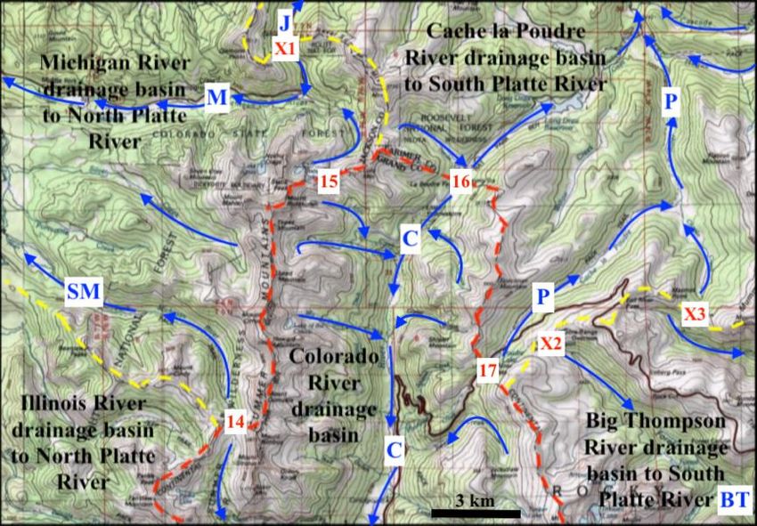
jgg.ccsenet.org                           Journal of Geography and Geology                         Vol. 12, No. 1; 2020

1.2 Geographic Setting
North-oriented North Platte River headwaters (seen in figure 1) flow into and through a mountain-surrounded
structural basin known as North Park to reach Wyoming. The Michigan (north) and Illinois (south) Rivers are the
unlabeled northwest-oriented North Platte River tributaries shown in North Park. North Park is located between
the Sierra Madre and Park Ranges (west), Medicine Bow and Never Summer Ranges (east), with the Rabbit Ears
Range to the south. The North Platte River has cut canyons into structural uplifts where it leaves North Park and
at various points along its north- and southeast-oriented Wyoming route. Southeast-oriented South Platte River
headwaters flow through South Park, another mountain-surrounded structural basin, before turning in a north-
northeast direction to enter deep canyons and eventually reach the Great Plains. Between North and South Parks,
south- and southwest-oriented Colorado River headwaters flow through Middle Park, another mountain-
surrounded structural basin, to reach Gore Canyon where the river flows through the Gore Range. Gore Canyon
floor elevations are in the 2200-meter range while Gore Range elevations to the south exceed 3500 meters and to
the north exceed 3200 meters, although abandoned valleys cross the Gore Range both to the south and the north
of Gore Canyon. Numerous mountain passes of varying depths cross the Park, Rabbit Ears, and Never Summer
Ranges and link north-oriented North Platte River headwaters valleys with Colorado River tributaries and cross
high mountain ridges to link north-, east- and southeast-oriented South Platte River headwaters and tributary
valleys with the Colorado River headwaters and tributary valleys.
1.3 Previous Work
Critical to the study reported here are paradigm neutral United States Geological Survey (USGS) detailed
topographic maps covering this paper’s entire study region (available at the USGS National Map website).
Drainage routes are shown and water eroded landforms such as valleys, drainage divides, asymmetric drainage
divides, water gaps, barbed tributaries, erosional escarpments, abandoned valleys, and mountain passes (and wind
gaps) are easily identified and interpreted. While detailed topographic maps are excellent tools for identifying
stream capture evidence and reconstructing former drainage routes, previous investigators have focused most of
their attention on the region’s high-level erosion surfaces (referred to as peneplains in earlier work). Bradley (1987)
in a Colorado Front Range erosion surface literature review notes how Davis (1911) recognized remnants of a
high-level Rocky Mountain peneplain or erosion surface (at about 11,500 feet or 3505 meters) above which some
of Colorado’s highest mountains now stand. Lee (1923, p. 2) comments “Davis believes that only two main cycles
of erosion are represented in the Rocky Mountains in Colorado–an older one resulting in the formation of a
peneplain and a younger one during which the canyons and cirques were excavated.” Lee then proposes that two
erosion surfaces are present with the lower erosion surface having an elevation of between 9,000 and 9,500 feet
(2743 and 2896 meters).
Little (1925, p. 497) observes “for practical purposes… the peneplains of the Front Range may be considered as
cut wholly across pre-Cambrian granites, gneisses, and schists, with the former especially abundant” and then
includes a table comparing how twelve different reports interpreted the number of Front Range peneplains and the
ages and names assigned to each of the suggested peneplains. That table demonstrates by the mid 1920s researchers
were disagreeing about the number and nature of Front Range erosion surfaces and those controversies continue
today with many Colorado geologists (e.g. Chapin and Kelley, 1997) considering the high-level Rocky Mountain
erosion surface to be late Eocene in age. In Wyoming, just to the north of this paper’s study region Mears (1993)
in a literature review notes most Wyoming geologists consider the high-level Rocky Mountain erosion surface to
be late Miocene in age.
Early workers did not have good quality topographic maps and while more recent researchers have had such access,
they have used other types of evidence when reconstructing the former drainage routes. For example, Hunt (1969,
p. 70) comments “In Oligocene time, the ancestral headwaters of the Colorado River discharged westward… from
the Park Range and possibly from the Front Range…. This course is recorded by river gravels under the tuffaceous
beds and lava, thought to be of early Pliocene age…. The gravels are at an altitude of 10,400 feet [3170 meters],
but part of this high altitude is due to 2,000 feet [610 meters] or more of late Tertiary or Quaternary uplift.” After
implying the uplift forced the Colorado River onto its present route Hunt continues (p. 71) “The present course of
the Colorado River through Middle Park, across the Gore Range… clearly is younger than the lavas and
sedimentary rocks in the basins and apparently became established by being superimposed across the structures at
the very end of Miocene time or the beginning of Pliocene time. The canyons, though, seem to be antecedent.”
Fan et al. (2014, p. 547) suggest “When and how the central Rocky Mountains (Rockies) … gained modern
topography remains a controversial question” and then suggest “the region underwent differential uplift to form
relief similar to that of today before the earliest Oligocene time.” Addressing evidence located in Wyoming (just

                                                          52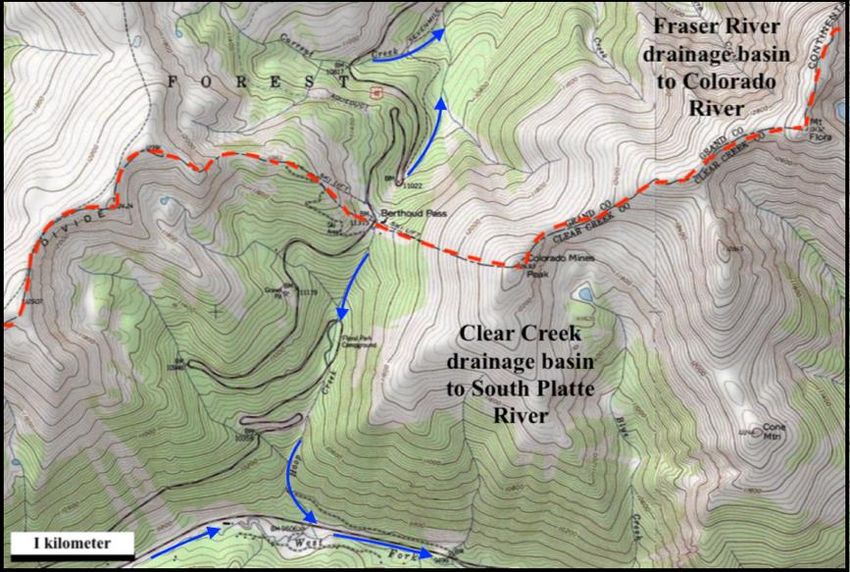
jgg.ccsenet.org                          Journal of Geography and Geology                       Vol. 12, No. 1; 2020

to the north of this paper’s study region) Flanagan and Montagne (1993, p. 597) comment “The depth and timing
of Wyoming’s basin fill remains a controversial subject. The essential question is whether Wyoming’s foreland
basins were filled volumetrically with more Cenozoic sedimentary material between late Eocene and Pleistocene
and then substantially excavated or whether the material in the basins today is the maximum sediment fill deposited
in the basins throughout the Cenozoic” and add, “the superposition of river systems suggest that these rivers were
flowing across basins filled with sedimentary material to elevations of approximately 9,000 ft. (2700 m).”
Chapin and Kelley (1997, p. 101) comment that following the Laramide orogeny the Rocky Mountain erosion
surface developed during the Eocene “by the coalescence of pediments and was protected from dissection by a
combination of volcanic cover and alluvial aprons that bordered the range. Change to a significantly wetter,
stormier climate beginning in the early Pliocene led to excavation of the protecting piedmont sediments and
allowed incision of the deep canyons that now cross the surface,” but do not provide the former drainage route
details. Wohl (2008, p. F01007), in a discussion of lower elevation Cache la Poudre River drainage areas, uses
evidence presented by Anderson et al. (2006) and Crowley et al. (2002) to suggest the Colorado “Front Range has
been relatively tectonically quiescent since the early Tertiary.” McMillan et al. (2006) suggest Oligocene and
Miocene sediments filled intramontane basins and partially buried the mountains before regional uplift raised the
mountains and initiated the Oligocene and Miocene basin sediment fill excavation. Such an interpretation
according to Pelletier (2009, p. 4) requires the intramontane basins of the southern Rocky Mountains to “have
undergone up to 1.5 km of erosion from the middle Miocene to the present.”
The new paradigm is based on detailed topographic map evidence and requires large south- and southeast-oriented
floods to have flowed across rising mountain ranges from the North Platte River drainage basin across what are
now Colorado River headwaters to reach South Platte River headwaters. To date new paradigm publications are
limited and document how the new paradigm explains previously unexplained northern Missouri River drainage
basin topographic map evidence (some are summarized in Clausen, 2018). The new paradigm requirement forces
recognition of a fundamentally different glacial history (than described by workers who have used the accepted
paradigm) in which a thick continental ice sheet created and occupied a deep “hole” by eroding the underlying
continental bedrock and by causing crustal warping that raised mountain ranges and plateau areas as immense melt
water floods flowed across them. Landform evidence supporting the new paradigm interpretation in the deep “hole”
floor area is given in Clausen (2019a) while subsequent papers (Clausen, 2019b) and (Clausen, 2019c, p. 410)
demonstrate “how prior to a drainage reversal that caused the melt water floods to flow back into the deep ‘hole’
space, south-oriented melt water floods flowed across the east-oriented Sweetwater River drainage basin and the
Great Divide Basin to reach the southwest-oriented Colorado River. Further… the east-oriented Sweetwater River
drainage basin is located along a deep “hole” rim segment, with the deep “hole” rim in Montana, Wyoming, and
northern Colorado following the present-day east-west continental divide.”
2. Research Method
The new paradigm discussed here was constructed after many attempts to solve previously unsolved drainage
history and erosional landform origin problems and was developed during two separate three-year systematic
studies of detailed topographic maps covering the entire Missouri River drainage basin (and several adjacent
drainage basins). The goal of these studies was to determine how drainage divides (between streams large enough
to be shown on the maps) originated. The first study used large mosaics of (hard copy) detailed topographic maps
and was done during the 1999-2001 time period. The unexpected results were fundamentally different from
anything in the published literature and could not be easily demonstrated to skeptical reviewers. That first study
was repeated during the 2011-2013 time period using National Geographic TOPO digital maps and software and
resulted in more than 500 detailed research notes in blog format describing origins for approximately 4000
different Missouri River drainage basin drainage divides which can be found at geomorphologyresearch.com.
The map interpretation techniques used to determine drainage divide origins first identify low points (or divide
crossings or mountain passes in the case of this paper) located along a drainage divide. These low points (unless
there is reason to believe otherwise) are interpreted to be where water once flowed in one direction or the other
across what is now a drainage divide. Valleys draining in opposite directions from the identified drainage divide
low point are interpreted to have first originated when water flowed across the drainage divide and the drainage
divide is interpreted to have originated when flow in one of those valleys was reversed (or otherwise changed) so
as to no longer cross the drainage divide. Reasons for the flow reversal or direction change are then sought. In
some cases, uplift at a rate faster than the rate of water erosion explains why the flow was reversed, although in
other situations stream capture, where a deeper valley beheaded the flow route crossing the drainage divide,
accounts for the flow reversals and drainage divide formation. Where numerous closely spaced streams once
crossed a drainage divide the present-day opposing drainage routes suggest the multiple streams may have been

                                                        53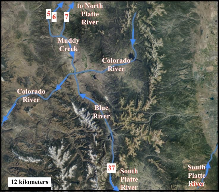
jgg.ccsenet.org                              Journal of Geography and Geology                              Vol. 12, No. 1; 2020

diverging and converging channels in a flood-formed anastomosing channel complex.
The study reported here used detailed topographic maps and tools available at the United States Geological Survey
(USGS) National Map website and began by identifying and listing in Tables 1 and 2 the named (and a few
unnamed) Colorado mountain passes located along the North Platte River-Colorado River and Colorado River-
South Platte River drainage divide segments making up the North American east-west continental divide. Listed
pass floor elevations were determined by use of the spot elevation tool and where possible checked against
published pass floor elevations. Listed pass depths are approximate and are based on nearby continental divide
high point elevations. Each listed pass links valleys on either side of the continental divide and was interpreted to
have been eroded by water flowing in one direction or the other. Listed passes were analyzed as described in the
results section below to determine how the passes were eroded and how the present-day drainage system evolved
as mountain uplift dismembered the previous drainage system.
3. Results
3.1 Passes Along the North Platte River-Colorado River Drainage Divide (in Colorado)
Named mountain passes (on detailed topographic maps) and a few unnamed mountain passes identified in
sequence (from the Wyoming border southward and eastward toward the Colorado River headwaters) along
Colorado’s North Platte River-Colorado River drainage divide segment of the east-west continental divide are
listed in Table 1. Each of the listed passes links a North Platte River tributary valley with a Colorado River tributary
valley. The passes are notched into what today are high mountain ridges and the depths indicate in approximate
numbers how much higher (in meters) nearby ridges are than the pass floor. Today it is difficult to imagine how
water could have flowed across the ridges as long and steep climbs on both sides are now needed to reach the
passes, yet water flowing across what is now a major drainage divide must have eroded each pass (glaciers
subsequently further modified some passes). The first three passes are in the Park Range located to the west of
North Park and link North Platte River tributaries with Elk River tributaries (the Elk River flows to the Yampa
River, which flows to the Green River, which flows to the Colorado River). The middle eight passes are located in
the Rabbit Ears Range (south of North Park) and the final passes are in the Never Summer Range (southeast and
east of North Park). The listed passes and numerous other unnamed and unlisted passes indicate that prior to
regional and mountain range uplift multiple streams of water flowed in one direction or the other across the Park,
Rabbit Ears, and Never Summer Mountain Ranges.

Table 1. Named and a few unnamed Colorado mountain passes (with floor elevations and depths in meters) linking
Colorado River tributary drainage routes with North Platte River drainage routes
                                                                                   North Platte drainage
 Pass Name               Floor elevation   Pass depth   Colorado drainage valley                              Pass orientation
                                                                                   valley
 1. Unnamed pass         2995              450-550      N Fork Elk River           Encampment River           N-S
 2. Red Dirt Pass        3520              130-150      Gold Creek                 Shafer Creek               NE-S
 3. Ute Pass             3345              250-300      Gold Creek                 Bear Creek                 NW-SE
 4. Buffalo Pass         3146              50-200       Fish Creek                 Summit Lake outlet         NE-SW
 5. Rabbit Ears Pass     2873              100-350      Muddy Creek                Grizzly Creek              E-W
 6. Muddy Pass           2655              350-750      Little Muddy Creek         Grizzly Creek              N-S
 7. Arapahoe Pass        2729              150-270      Diamond Creek              Indian Creek               NE-SW
 8. unnamed pass         2903              100-300      Lindsey Creek              Indian Creek               NE-SW
 9. Troublesome Pass     3056              400-450      Haystack Creek             Willow Creek               N-S
 10. Willow Creek Pass   2944              400-600      Pass Creek                 Snyder Creek               N-S
 11. Illinois Pass       3047              150-350      Trout Creek                Illinois River             N-W
 12. unnamed pass        3093              150-350      Willow Creek               Illinois River             N-S
 13. Bowen Pass          3430              200-300      Bowen Gulch                Illinois River             W-SE
 14. Baker Pass          3432              300-400      Baker Gulch                S Fork Michigan River      N-S
 15. Thunder Pass        3450              300-350      Lulu Creek                 Michigan River             N-S

Pass number 1 in Table 1 (seen in Figure 2), while not named on the map, links north-oriented Encampment River
headwaters (draining to the North Platte River) with the west-oriented North Fork Elk River valley (draining to
the Elk, Yampa, Green, and Colorado Rivers). A Tweto (1976) geologic map shows glacial deposits in both valleys,
but more prevalent in the north-oriented valley. To the north of Figure 2 a 370-meter deep 10-kilometer long and

                                                             54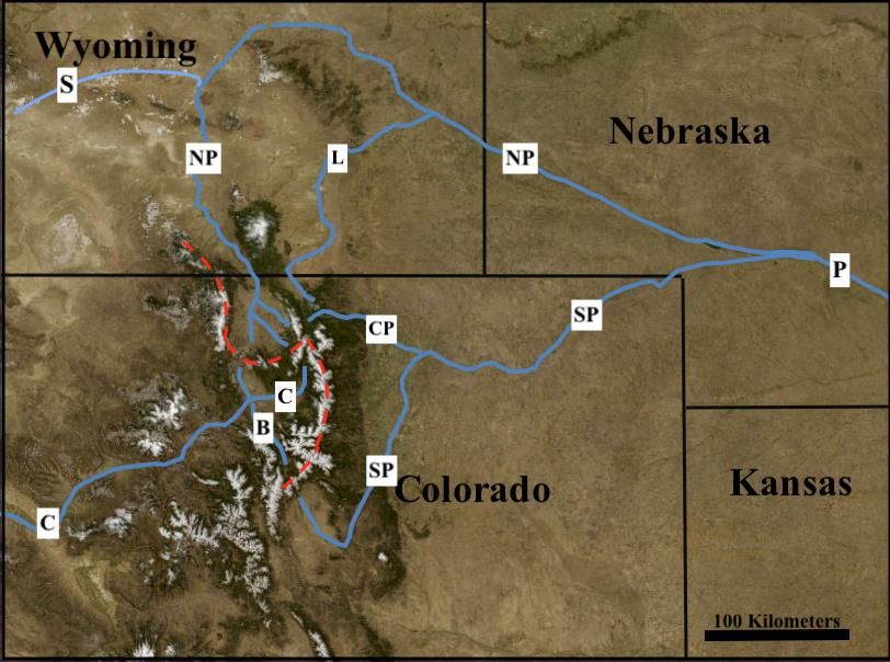
jgg.ccsenet.org                          Journal of Geography and Geology                       Vol. 12, No. 1; 2020

west- and north-oriented valley diverges from and then converges with the comparably deep north-oriented
Encampment River valley with only a 35-meter high drainage divide separating the two valleys. Other valleys also
diverge from and then converge with the north-oriented Encampment River valley. These diverging and converging
valleys suggest large and prolonged diverging and converging streams of water carved deep valleys into what must
have been rising mountains. The “T” intersection in Figure 2 suggests water first flowed in a south direction at an
elevation nearly as high as the adjacent mountain tops and was captured by headward erosion of the west-oriented
North Fork Elk River valley and continued to flow in a south direction as the pass valley was eroded. Continued
regional and mountain uplift eventually forced a reversal of flow to create what is today the drainage divide and
the north-oriented Encampment River.

 Figure 2. Modified topographic map from USGS National Map website showing an unnamed (on topographic
  maps) mountain pass (number 1 in Table 1) across the east-west continental divide (dashed red line) linking
 north-oriented Encampment River (E) flowing to the north-oriented North Platte River with west- and south-
oriented North Fork Elk River (NE) with its water eventually reaching the Colorado River. The contour interval
                                            is 40 feet (12 meters)

Red Dirt and Ute Passes provide further evidence for south-oriented flow across the high-level surface now
preserved along ridge tops. Red Dirt Pass is located on a southeast-oriented continental divide segment and links
northeast-oriented Shafer Creek headwaters (flowing to the North Platte River) with south-oriented Gold Creek
headwaters (in the Colorado River drainage basin) while Ute Pass is located almost directly south of Red Dirt Pass
on a southwest-oriented continental divide segment and links south-oriented Gold Creek headwaters with
southeast-oriented Bear Creek which flows to the north-oriented North Platte River as a barbed tributary (the
south-oriented Gold Creek headwaters valley makes a turn to the southwest and west just to the north of Ute Pass).
Present-day drainage routes can be explained if headward erosion of a west-oriented Gold Creek valley (from the
Middle Fork Elk River valley in the Colorado River drainage basin) captured south-oriented water that had been
flowing across Red Dirt Pass (from the present-day North Platte River drainage basin), next along the south-
oriented Gold Creek headwaters alignment (now in the Colorado River drainage basin), then across Ute Pass, and
finally back into the present-day North Platte River drainage basin where it flowed along the southeast-oriented
Bear Creek alignment to join south-oriented water flowing on the present-day north-oriented North Platte River
alignment. To cross Red Dirt Pass such south-oriented water must have flowed on a surface equivalent to what are

                                                        55
jgg.ccsenet.org Journal of Geography and Geology Vol. 12, No. 1; 2020
now some of the region’s highest ridge tops and there must have been sufficient volumes of water over prolonged
periods of time to carve what are today deep valleys into rising mountains before the continued uplift forced a
reversal of flow to create what is today the north-oriented North Platte River drainage system.
Buffalo Pass (number 4 in Table 1) links northeast- and east-oriented Chedsey Creek flowing to the north-oriented
North Platte River with southwest-oriented Fish Creek flowing to a north-oriented Yampa River segment. To the
north of where Fish Creek joins it the Yampa River turns in a west direction and eventually joins the south-oriented
Green River with its water then reaching the Colorado River, while to the south a large through valley links the
north-oriented Yampa River headwaters valley with a south-oriented Colorado River tributary valley and suggests
the north-oriented Yampa River headwaters are flowing in what at one time was a major south-oriented flow route.
Gravels described by Madole (1991) indicate the Yampa River headwaters have flowed in a north direction since
Rocky Mountain glaciation meaning the south-oriented drainage that eroded Buffalo Pass, passes number 1-3, and
probably the other Table 1 passes must have predated glaciation in what are now high Rocky Mountain regions.
Rabbit Ears Pass is located between south-oriented Muddy Creek (flowing to the Colorado River) and southeast-
and northeast-oriented Grizzly Creek (flowing to the North Platte River) and is probably best explained by flow
that diverged from the upper Muddy Creek valley and then moved along the southeast-oriented Grizzly Creek
headwaters alignment to reach and erode Muddy Pass to reach and flow along the Little Muddy Creek alignment
to converge with the Muddy Creek route again. Regional (and Rabbit Ears Range) uplift dismembered the
diverging and converging flow routes with headward erosion of the northeast-oriented Grizzly Creek valley
capturing the dismembered southeast-oriented Grizzly Creek headwaters.
Passes across the west-to-east oriented Rabbit Ears Range include Muddy Pass (number 6 in Table 1) and proceed
eastward to Illinois Pass (number 11) with passes 12-15 being in the Never Summer Range. The Rabbit Ears and
Never Summer Ranges were local volcanic centers in what was an extensive Middle Tertiary volcanic field
(Stevens, 1975) and it is possible some passes represent low points between constructional landforms. However,
all listed passes in Table 1 link North Platte River tributary valleys with south-oriented valleys draining directly to
the Colorado River strongly suggesting that all passes were water eroded. Based on present-day topography it is
difficult to imagine how streams flowing in one direction or the other could have crossed what is now a high
drainage divide. However, diverging and converging streams of water must have eroded deep valleys into the
rising Rabbit Ears and Never Summer Mountain Ranges until the uplift rate outpaced the erosion rate with the
water first being channeled to flow into what are now the deeper pass valleys while at the same time forcing
reversals of flow to create what eventually became North Platte River headwaters drainage routes. It is possible
diverging and converging streams of water crossed what are now the Rabbit Ears and Never Summer Ranges not
only as uplift was occurring, but also as volcanic activity was underway.
3.2 Passes along the South Platte River-Colorado River Drainage Divide Segment
Named passes (on USGS detailed topographic maps) along the South Platte River-Colorado River drainage divide
are identified in Table 2 and Figure 3 provides a modified topographic map from the USGS National Map website
showing how the continental divide loops around the south-oriented Colorado River headwaters and locations of
Baker Pass and Thunder Pass (14 and 15 in Table 1), La Poudre Pass and Milner Pass (16 and 17 in Table 2),
Cameron Pass (X1 in Figure 3, floor elevation 3,132 meters, depth of 350-450 meters), Forest Canyon Pass (X2,
floor elevation 3450 meters, depth 150-300 meters), and Chapin Pass (X3, floor elevation 3400 meters, depth 225-
375 meters). Cameron Pass links a south-oriented Michigan River tributary with north-oriented Joe Wright Creek
and Forest Canyon and Chapin Passes link the northeast-oriented Cache la Poudre River headwaters valley with
southeast-oriented Big Thompson River headwaters (both rivers use different routes to reach the South Platte
River).
To the north of Figure 3 Joe Wright Creek has been dammed to form Chambers Lake, which in addition to having
an outlet in the Joe Wright Creek valley leading to the north- and east-oriented Cache la Poudre River (which flows
to the South Platte River) also has an outlet to the north-oriented Laramie River, which flows to the North Platte
River (see Figure 1). Workman et al (2018) show Cameron Pass located along a north-south oriented fault line
although erosion of the Cameron Pass valley and the diverging Chambers Lake outlet routes are easiest to explain
if after mountain uplift blocked south-oriented flow across Baker and Thunder Passes south- and east-oriented
water turned in a north direction to further erode the Cameron Pass valley and then at the present-day Chambers
Lake location to split into diverging channels with one channel leading to the Laramie River and the other channel
to the Cache la Poudre River. Mountain uplift eventually blocked flow to the Laramie River valley and soon
thereafter through Cameron Pass to create the west- and northwest-oriented Michigan River drainage system
leading to what was then newly reversed flow along what is now the north-oriented North Platte River alignment.
56jgg.ccsenet.org Journal of Geography and Geology Vol. 12, No. 1; 2020
La Poudre Pass links the south-oriented Colorado River headwaters valley with lower gradient northeast-oriented
La Poudre Pass Creek, which flows to the north- and east-oriented Cache la Poudre River. Milner Pass is 178
meters higher than La Poudre Pass and links northeast- and north-oriented Cache la Poudre River headwaters with
a short south-oriented Colorado River tributary valley. Map evidence seen in Figure 3 (and better seen in more
detailed topographic maps) suggests that while regional and mountain uplift was occurring channels of south-
oriented water diverged so as to follow what are now the north-oriented Cache la Poudre River and La Poudre Pass
Creek valleys to reach an actively eroding south-oriented Colorado River headwaters valley until such time as
mountain uplift outpaced erosion on the Milner Pass route and all south-oriented flow was forced to flow along
what is today the northeast-oriented La Poudre Pass Creek route. Continued south-oriented flow on the La Poudre
Pass Creek route further eroded the La Poudre Pass valley while approximately 178 meters of additional uplift
occurred and the deep south-oriented Colorado River headwaters valley eroded 5-6 kilometers northward from the
Milner Pass location. Northwest oriented and barbed Colorado River tributaries suggest the Colorado River
headwaters valley (and the northeast-oriented Cache la Poudre River headwaters valley) also eroded headward
across southeast-oriented flow channels that had once moved water to the southeast-oriented Big Thompson River
headwaters.
Wohl (2008) interprets a Madole et al. (1998) map to suggest “Pleistocene glaciers extended down Poudre Canyon
to 2325 m,” which is lower than any areas seen in Figure 3. Text accompanying the Madole et al map (which does
not address evidence for glaciation in the North Platte River or Colorado River drainage basins) suggests the Cache
la Poudre valley glacier “was about 45 km long and as much as 600 m thick.” Topographic map evidence seen in
Figure 3 and in more detailed topographic maps supports the Madole et al. interpretation and also suggests valley
glaciers also once filled most valleys seen in Figure 3. While glaciers probably streamlined, deepened, and
otherwise altered valleys and mountain ridges seen in Figure 3 almost all valleys (including the mountain passes)
were eroded prior to the glaciation.
Table 2. Mountain passes (with floor elevations and depths in meters) linking Colorado River headwaters and
tributary valleys with South Platte River headwaters and tributary valleys
Floor Pass Colorado drainage South Platte drainage Pass
Pass Name
elevation depth valley valley Orientation
16. La Poudre Pass 3101 700-800 Colorado River La Poudre Pass Creek NE-SW
17. Milner Pass 3279 400-500 Beaver Creek Cache La Poudre R. NE-SW
18. Sprague Pass 3569 100-200 Tonahutu Creek Spruce Creek NE-SW
19. Ptarmigan Pass 3709 100-150 Ptarmigan Creek Fern Creek NE-SW
20. Andrews Pass 3645 200-350 Hallett Creek Andrews Creek NE-SW
21. Stone Man Pass 3812 200-500 North Inlet Glacier Creek NE-SW
22. Boulder Grand
3681 300-350 East Inlet North St Vrain Creek E-W
Pass
23. Buchanan Pass 3610 300-350 Buchanan Creek Middle St Vrain Ck E-W
24. Pawnee Pass 3825 120-200 Pawnee Lake outlet Blue Lake outlet E-W
25. Arapaho Pass 3629 300-400 Arapaho Creek Middle Boulder Creek N-SE
26. Devils Thumb Pass 3580 80-180 Cabin Creek Jasper Creek NW-SE
27. Rollins Pass 3559 100-200 Ranch Creek S Fk Mid Boulder Ck NE-SW
28. Berthould Pass 3449 400-450 Fraser River Hoop Creek NNE-SSW
29. Vasquez Pass 3565 300-400 Vasquez Creek Clear Creek N-S
30. Jones Pass 3796 100-150 Jones Creek W Fk Clear Creek E-W
31. Loveland Pass 3655 350-400 Clear Creek N Fk Snake River N-S
32. Argentine Pass 4025 180-220 Peru Creek Leavenwork Creek W-E
33. Webster Pass 3700 160-220 Snake River Handcart Gulch N-S
34. Georgia Pass 3531 500-600 S Fk Swan River Michigan Creek N_S
35. French Pass 3672 300-400 French Gulch French Creek N-S
36. Boreas Pass 3499 450-500 Indiana Creek N Tarryall Creek N-S
37. Hoosier Pass 3517 500-600 Blue River Mid Fk S Platte River N-S
57jgg.ccsenet.org Journal of Geography and Geology Vol. 12, No. 1; 2020
Figure 3. Modified topographic map from USGS National Map website showing drainage divides in Colorado
River headwaters area. Dashed red line shows the continental divide and dashed yellow lines show other
drainage divides. Blue letters identify rivers BT-Big Thompson River, C-Colorado River, J-Joe Wright Creek, M-
Michigan River, P-Cache la Poudre River, and SM-South Fork Michigan River. Red numbers are passes listed in
Tables 1 and 2. X1 is Cameron Pass, X2 is Forest Canyon Pass, and X3 is Chapin Pass. Contour interval is 50
meters
Erosion of the deep La Poudre and Milner Pass valleys is best explained by prolonged floods of south-oriented
water coming from outside the study region that flowed across what are now Cache la Poudre drainage basin areas
with elevations today in excess of 3279 meters into what must have been an actively eroding Colorado River
headwaters valley while at the same time the region and mountains were being uplifted by as much as 800 meters
or more. Eventually regional and mountain uplift outpaced erosion on the La Poudre Pass route and forced a
reversal of flow so as to create what is today the north-oriented Cache la Poudre River drainage route seen in
Figure 3, (which diverging and converging abandoned valleys now link with the north-oriented Laramie River
valley). Headward erosion of a deeper east-oriented Cache la Poudre River valley captured the newly reversed
flow and subsequent to the Cache la Poudre River flow reversal (in Figure 3 map area) significant regional and
mountain uplift must have continued to produce the present-day La Poudre and Milner Pass elevations. While
difficult to imagine today the north-oriented Cache la Poudre River headwaters valleys originated as south-oriented
flood flow routes.
Other passes listed in Table 2 are to the south of Figure 3 and are listed in sequence from the north to the south. In
addition to the named passes there are numerous unnamed (on the topographic maps) passes suggesting that at one
time dozens of streams or diverging and converging flood flow channels crossed what is now the high elevation
continental divide. While pass and valley orientations near the continental divide can be significantly different
most valleys on the South Platte River side drain to east- or southeast-oriented South Platte River tributaries and
many valleys on the Colorado River side drain to northwest- or north-oriented Colorado River tributaries. The
north-northeast oriented South Platte River in addition to its southeast-oriented headwaters also has southeast-
oriented tributaries, which join the South Platte River as barbed tributaries while southwest-oriented Colorado
River segments have many southeast- and northwest-oriented barbed tributaries. The abundance of northwest-
southeast oriented drainage routes suggests prior to regional and mountain uplift and to headward erosion of the
deep southwest- and south-oriented Colorado River valley (and the north-northeast-oriented South Platte River
58jgg.ccsenet.org Journal of Geography and Geology Vol. 12, No. 1; 2020
valley) numerous southeast-oriented streams or diverging and converging flood flow channels crossed the region
and the north-northeast oriented South Platte River valley and subsequently the southwest- and south-oriented
Colorado River valley eroded headward into a rising region and rising mountains to capture southeast-oriented
flood flow.
Pass orientations appear to reflect the continental divide orientation, which along the South Platte River-Colorado
River drainage divide changes frequently and significantly. Sprague, Ptarmigan, Andrews, Stone Man, and Rollins
Passes are oriented in northeast to southwest directions and cross discontinuous continental divide segments
oriented in a northwest to southeast direction. Boulder Grand, Buchanan, Pawnee, Devils Thumb, and Jones Passes
cross discontinuous continental divide segments oriented in more of a north to south direction. Arapahoe, Berthold,
Vasquez, Loveland, Webster, Georgia, French, Boreas, and Hoosier Passes cross discontinuous continental divide
segments oriented in more of an east to west direction. While each pass has unique features close investigation of
those unique features suggests multiple northwest to southeast oriented streams or diverging and converging flood
flow channels once crossed the region as what is now the east-west continental divide was being formed.
Figure 4. Modified topographic map from USGS National Map website showing the Sprague Pass area. Sprague
Pass is at location A and locations B and C are passes discussed in the text. The red dashed line follows the
continental divide. The contour interval is 40 feet (12 meters)
Sprague Pass (seen in Figure 4) has a northeast-southwest orientation and links the northeast-oriented Spruce
Creek valley with a southwest-oriented Tonahutu Creek valley segment, which at first glance does not support
erosion by southeast-oriented water. However, to the southwest of Sprague Pass Tonahutu Creek begins as a
southeast-oriented stream at a 200- to 300-meter deep northwest-to southeast oriented pass (at location B in Figure
4). To the northwest of that pass is the (unseen in Figure 4) southeast- and southwest-oriented headwaters valley
of Onahu Creek. A pass similar to the pass at location B links the southeast-oriented Onahu Creek headwaters
valley with the northwest-oriented Timber Creek headwaters valley, with Timber Creek turning in a southwest and
then northwest direction to join the south-oriented Colorado River as a barbed tributary. Looking in the other
direction location C identifies a 200-meter deep pass linking a northwest-oriented Tonahutu Creek tributary valley
with the south-oriented Ptarmigan Creek valley, which flows to northwest- and southwest-oriented North Inlet.
Such passes similar to those at locations B and C suggest headward erosion of southwest-oriented Colorado River
tributary valleys systematically dismembered a large southeast-oriented stream or river flowing adjacent to and
roughly parallel to the present-day continental divide. To the east of Figure 4 Spruce Creek joins the southeast-
59jgg.ccsenet.org Journal of Geography and Geology Vol. 12, No. 1; 2020
oriented Big Thompson River headwaters which flow in a similar southeast-oriented valley before turning in an
east direction, although to the southeast of that turn the north-northwest oriented Aspen Brook valley is linked by
Wind River Pass with the south- and southeast-oriented Tahosa Creek valley. In other words, the continental divide
segment seen in Figure 4 once separated two or more large southeast-oriented streams or rivers and a southwest-
oriented stream of water diverging from the channel on the South Platte River side to the channel on the Colorado
River side probably eroded Sprague Pass.
Figure 5. Modified topographic map from USGS National Map website showing the Berthould Pass area. The
dashed red line follows the continental divide and blue arrows emphasize present-day drainage directions. The
contour interval is 40 feet (12 meters)
While the number of passes along the continental divide’s South Platte River-Colorado River drainage divide
segment is more than this finite paper can discuss the named and unnamed passes can be used to reconstruct what
must have been large streams of water that once flowed adjacent to and across what is now the continental divide.
Figure 5 illustrates Berthould Pass, which has a north-northeast to south-southwest orientation with a south-
southwest stream to the south draining into an east-southeast oriented stream. Drainage to the north of Figure 5
leads to the northwest-oriented Fraser River, which joins the south- and southwest-oriented Colorado River as a
barbed tributary (although immediately downstream from that confluence the Colorado River makes a short
northwest-oriented jog). To the north of where the Fraser River joins the Colorado River is south-southeast oriented
Willow Creek, which begins at Willow Creek Pass (number 10 in Table 1) and which once may have also been fed
by water crossing the continental divide at other unnamed Rabbits Ears Mountain passes. [Willow Creek now joins
the Colorado River upstream from the Fraser River, but highway 125 follows a north-south oriented through valley
linking the Willow Creek valley with the Fraser River mouth.] In other words, present-day drainage routes suggest
a hypothesis that south-southeast oriented water from what is now the North Platte River drainage basin crossed
what is now the continental divide at Willow Creek Pass and flowed across what is now the deep southwest-
oriented Colorado River valley and then along what is now the northwest-oriented Fraser River alignment and to
cross what is now the continental divide at Berthould Pass and then to flow in a southwest direction along the
alignment of are now the northeast-oriented West Fork Clear Creek headwaters. That south-oriented stream or
river was then dismembered as uplift raised the mountains and region and headward erosion of deep valleys
systematically captured the flow from the southeast to the northwest and diverted the water in other directions.
60jgg.ccsenet.org Journal of Geography and Geology Vol. 12, No. 1; 2020
Figure 6. Modified imagery from USGS National Map website showing how south-southeast oriented Muddy
Creek and north-northwest oriented Blue River drainage routes link Rabbit Ears (5), Muddy (6), and Arapahoe
(7) Passes across the North Platte River-Colorado River drainage divide with Hoosier Pass (37) across the
Colorado River-South Platte River drainage divide. Southeast-oriented drainage from Hoosier Pass flows to the
South Fork South Platte River. Note north-northeast South Platte River in the Figure 6 southeast corner
Easier to observe evidence illustrating how Colorado River tributary routes link passes across the North Platte
River-Colorado River divide with passes across the Colorado River-South Platte River divide is seen in Figure 6
where south-southeast oriented Muddy Creek and the north-northwest oriented Blue River link Rabbit Ears,
Muddy, and Arapahoe Passes in the north with Hoosier Pass across the Colorado River-South Platte River divide
to the south. While not shown (in Figure 6) Boreas, French, and Georgia Passes are to the northeast of Hoosier
Pass and link northwest-oriented Blue River tributary valleys with southeast-oriented South Platte River tributary
valleys. The passes leading from the North Platte River drainage basin to the southeast-oriented Muddy Creek
valley and from the Blue River drainage basin to the South Platte River headwaters suggest south- and southeast-
oriented diverging and converging channels from what is now the north-oriented North Platte River drainage basin
initially moved water across what must have been rising mountains ridges into the southeast-oriented South Platte
River headwaters area. Colorado River valley headward erosion, probably aided by regional and mountain uplift,
captured the south-southeast oriented flow, which reversed flow on the beheaded channels to create what are today
the north-northwest oriented Blue River drainage system and the Colorado River-South Platte River drainage
divide. Subsequently water continued to flow from the North Platte River drainage basin across Rabbit Ears,
Muddy, and Arapahoe Passes and along the Muddy Creek alignment to the newly formed Colorado River valley
until mountain and regional uplift ended flow across Rabbit Ears Pass first, Arapahoe Pass second, and finally
Muddy Pass and to a reversal of flow in the North Platte River valley.
One previous investigator who did observe a relationship between the passes and the Colorado tributary valleys
61jgg.ccsenet.org Journal of Geography and Geology Vol. 12, No. 1; 2020
was Eaton (1986) who commented on similarities between this paper’s study region and the mid-Atlantic ridge.
Eaton (p. 179-180) discusses axial valleys and drainage and in regard to the Blue River and Hoosier Pass
orientation and notes “Major faults and Neogene movement flank the Blue river… The valley is half graben that
has been largely stripped of its sedimentary fill. Near-source Neogene conglomerates are preserved as small
patches faulted against Precambrian bedrock.” While a case can be made that regional faults have determined the
locations of some passes and drainage routes the faults alone do not provide a complete explanation. Massive
erosion also occurred and the question needing to be answered is did that erosion take place as massive southeast-
oriented floods crossed rising mountains (i.e. as in the new paradigm interpretation) or did the erosion take place
more gradually as many previous investigators have suggested (i.e. as in the accepted paradigm interpretation)?
4. Discussion and Conclusion
Mountain passes (and other low points along drainage divides), drainage route and valley orientations, and stream
capture evidence (e.g. elbows of capture and barbed tributaries) are clues to the existence and nature of a previous
regional drainage system. Reconstructing former drainage systems is similar to solving a giant sudoku puzzle. Like
in a sudoku puzzle all clues are important and the correct solution, once found, can be easily checked by any
investigator willing to do so. The numerous high elevation mountain passes crossing North Platte River-Colorado
River and Colorado River-South Platte River drainage divide segments of North America’s east-west continental
divide and barbed tributaries flowing to the south- and southwest-oriented Colorado River headwaters (as
discussed here) provide a selected set of easy-to-observe (on detailed topographic maps) evidence that previous
investigators (following accepted paradigm rules) have yet to explain and which is consistent with the new
paradigm prediction that immense south- and southeast-oriented floods once flowed from the present-day north-
oriented North Platte River headwaters area across rising mountain ranges and what is now the south- and
southwest-oriented Colorado River headwaters area and then across more rising mountain ranges to reach east-
and southeast-oriented valleys leading to the north-northeast oriented South Platte River valley, although many
questions remain.
Questions arising from the new paradigm’s ability to explain the Platte River-Colorado River drainage divide
mountain pass origins include where did the floodwaters originate and why did mountain ranges rise as immense
south-oriented floods flowed across them? The new paradigm rule forces recognition of a large continental ice
sheet thick and heavy enough to deeply erode the underlying bedrock and to cause crustal warping so as to create
and occupy a deep “hole” with at least some of what is today the east-west continental divide in northern Colorado
being a segment of that deep “hole’s” southwest rim. Such an ice sheet could have produced prolonged and
immense south-oriented melt water floods, however, accepted paradigm rules do not recognize a North American
continental ice sheet that deeply eroded the underlying bedrock and that caused crustal warping so as to create and
occupy a deep “hole,” nor do accepted paradigm rules permit melt water from any recognized North American
continental ice sheet to have reached Colorado, much less to have flowed across what are now high Colorado
continental divide segments. In other words, the two paradigms lead to fundamentally different North American
middle and late Cenozoic geologic and glacial histories and the new paradigm by successfully explaining the listed
mountain pass and discussed drainage feature origins is also challenging the accepted paradigm’s middle and late
Cenozoic regional geologic and glacial history interpretation. A full discussion of the two alternate middle and late
Cenozoic regional geologic histories is beyond this paper’s scope, although investigators need to be aware the new
paradigm successfully explains drainage divide and drainage system evidence the accepted paradigm has yet to
explain.
Acknowledgements
During the mid 1960s Arthur Strahler, then at Columbia University, and Brainerd “Nip” Mears, Jr., then at the
University of Wyoming, introduced the author of this paper to numerous unsolved drainage history problems.
Preliminary work leading to this paper was done while employed as a faculty member at Minot State University
(North Dakota) where other faculty members, library staff, and students provided valuable assistance.
Conflict of interests
The authors declare that there is no conflict of interests regarding the publication of this paper.
Reference
Anderson, D. L. (2002). Occam’s razor: Simplicity, complexity, and global dynamics. Proceeding of the American
Philosophical Society, 146(1), 56-76.
Anderson, R. S., Riihimaki, C. A., Safran, E. B., & MacGregor, K. R. (2006). Facing reality: Late Cenozoic
evolution of smooth peaks, glacially ornamented valleys, and deep river gorges of Colorado’s Front Range.
62jgg.ccsenet.org Journal of Geography and Geology Vol. 12, No. 1; 2020
In S. D. Willett et al. (Eds.), Tectonics, Climate, and Landscape Evolution. Geological Society of America
Special Paper. 398. 397-418. https://doi.org/10.1130/2006.2398(25)
Bradley, W. C. (1987). Erosion surfaces of the Colorado Front Range: A review. In W. L. Graf (Ed.), Geomorphic
systems of North America: Geological Society of America Centennial (Special Volume 2, pp. 215-220).
Chapin, C. E., & Kelley, S. A. (1997). The Rocky Mountain erosion surface in the Front Range of Colorado. In D.
W. Boyland, & S. A. Sonnenberg (Eds.), Geologic history of the Colorado Front Range (pp. 101-114). Denver,
Colorado: Rocky Mountain Association of Geologists. https://doi.org/10.3133/b730a
Clausen, E. (2018). Deep Erosion by Continental Ice Sheets: A Northern Missouri River drainage basin perspective,
North America. Current Research in Geoscience, 8, 27-38. https://doi.org/10.3844/ajgsp.2018.27.38
Clausen, E. (2019a). How a fundamentally different and new glacial history paradigm explains North America
glaciated Prairie Region erosional escarpments and drainage patterns. Earth Science Research, 8(2), 23-34.
https://doi.org/10.5539/esr.v8n2p2
Clausen, E. (2019b). Topographic map interpretation of Bighorn River-Wind River drainage divide located east of
Wyoming’s Wind River Canyon, USA. Universal Journal of Geoscience, 7(2) 56-67.
https://doi.org/10.13189/ujg.2019.070202
Clausen, E. (2019c). Use of topographic map evidence to test a recently proposed regional geomorphology
paradigm: Wind River-Sweetwater River drainage divide area, Central Wyoming, USA. Open Journal of
Geology, 9, 404-423. https://doi.org/10.4236/ojg.2019.98027
Crowley, P. D., Reiners, P. W., Reuter, J. M., & Kaye, G. D. (2002). Laramide exhumation of the Bighorn
Mountains, Wyoming: An apatite (U-Th) He thermochronology study. Geology, 30, 27-30.
https://doi.org/10.1130/0091-7613(2002)0302.0.co;2
Davis, W. M. (1911). The Colorado Front Range: Annals of the Association of American Geographers (Vol. 1, pp.
21-84).
Eaton, G. P. (1986). A tectonic redefinition of the Southern Rocky Mountains. In B. Johnson & A. W. Bally (Eds.),
Intraplate Deformation: Characteristics, Processes and Causes. Tectonophysics, 132, 163-194.
https://doi.org/10.1016/0040-1951(86)90031-4
Fan, M., Heller, P., Allen, S., & Hough, B. G. (2014). Middle Cenozoic uplift and concomitant drying in the central
Rocky Mountains and adjacent Great Plains. Geology, 42(6), 547-550. https://doi.org/10.1130/g35444.1
Flanagan, K. M., & Montagne, J. (1993). Neogene stratigraphy and tectonics of Wyoming. In A. W. Snoke, J. R.
Steidtmann, & S. M. Roberts (Eds.), Geology of Wyoming. Geological Survey of Wyoming Memoir, 5, 572-
607.
Hunt, C. B. (1969). Geologic history of the Colorado River. In The Colorado River and John Wesley Powell:
United States Geological Survey Professional Paper (Vol. 669, pp. 59-130). https://doi.org/10.3133/pp669c
Kuhn, T. S. (1970). The Structure of Scientific Revolutions (2nd ed., p. 210). University of Chicago Press, Chicago.
Lee, W. (1923). Peneplains of the Front Range and Rocky Mountain National Park, Colorado: Chapter A. In
Contributions to the Geography of the United States, 1922, United States Geological Survey Bulletin (Vol.
730, p. 17). https://doi.org/10.3133/b730a
Little, H. P. (1925). Erosional cycles in the Front Range of Colorado and their correlation. Bulletin of the
Geological Society of America, 36, 495-512. https://doi.org/10.1130/gsab-36-495
Madole, R. (1991). Yampa River Basin. In M. C. Reheis (Ed.), Quaternary history of some southern and central
Rocky Mountain basins, chapter 14. In R. B. Morrison (Ed.), Quaternary Nonglacial Geology: Conterminous
U.S., vol. K-2 of The Geology of North America. Geological Society of America, 427-440.
https://doi.org/10.1130/dnag-gna-k2.407
Madole, R. F., Van Sistine, D. P., & Michael, J. A. (1998). Pleistocene glaciation in the upper Platte River drainage
basin, Colorado. United States Geological Survey Geologic Investigation Series Map I-2644, 1(309), 280.
McMillan, M. E., Heller, P. L., & Wing, S. L. (2006). History and causes of post-Laramide relief in the Rocky
Mountain orogenic plateau. Geological Society of America Bulletin, 118(3/4), 393-405.
https://doi.org/10.3133/i2644
Mears, B. Jr. (1993). Geomorphic history of Wyoming and high-level erosion surfaces. In A. W. Snoke, J. R.
Steidtmann, & S. M. Roberts (Eds.), Geology of Wyoming: Geological Survey of Wyoming Memoir (Vol. 5,
63You can also read