Use of Topographic Map Evidence From Drainage Divides Surrounding Wyoming s Great Divide Basin to Compare Two Fundamentally Different Regional ...
←
→
Page content transcription
If your browser does not render page correctly, please read the page content below
Earth Science Research; Vol. 9, No. 1; 2020
                                                                                       ISSN 1927-0542      E-ISSN 1927-0550
                                                                       Published by Canadian Center of Science and Education

Use of Topographic Map Evidence From Drainage Divides Surrounding
Wyoming‟s Great Divide Basin to Compare Two Fundamentally Different
                Regional Geomorphology Paradigms
                                                       Eric Clausen
Correspondence: Eric Clausen, 100 West Ave D-17, Jenkintown, PA 19046, United States.
E-mail: eric2clausen@gmail.com

Received: October 28, 2019             Accepted: December 27, 2019              Online Published: January 11, 2020
doi:10.5539/esr.v9n1p45               URL: https://doi.org/10.5539/esr.v9n1p45

Abstract
Divide crossings (or low points or gaps) notched into the North American east-west continental divide segments
completely encircling Wyoming‟s Great Divide Basin interior drainage region (as observed on detailed topographic
maps) are used to compare the commonly accepted regional geomorphology paradigm with a fundamentally different
and new regional geomorphology paradigm. Paradigms are sets of rules governing how a scientific discipline conducts
its research and are judged on their ability to explain observed evidence. Published literature is used to contrast an
accepted paradigm interpretation that east-oriented drainage previously flowed across what is now the Great Divide
Basin with the new paradigm basic requirement that mountain range and continental divide uplift occurred while
immense south-oriented floods flowed across them. Numerous divide crossings are notched into the continental divide
segments now completely encircling the relatively flat-floored Great Divide Basin interior drainage area and divide
crossings observed along each of the Great Divide Basin‟s north, east, south, and west margins are described and
interpreted first from the accepted paradigm perspective (using published literature interpretations to the extent possible)
and second from the new paradigm perspective. The published literature does not mention most of the described divide
crossings, much less provide explanations for their origins, perhaps because the accepted paradigm cannot satisfactorily
explain those origins. In contrast the new paradigm successfully explains most if not all of the described (and observed,
but undescribed) divide crossings, although the new paradigm requires a completely different middle and late Cenozoic
regional geologic history than what most published regional geology literature describes.
Keywords: Continental Divide, Crooks Gap, drainage divide crossings, Leucite Hills, Muddy Gap, Sinclair Gap,
Wamsutter Gap, Wyoming
1. Introduction
1.1 Statement of the Problem
Southwestern Wyoming‟s Great Divide Basin (seen in figure 1) is a closed basin, approximately 104 km2 in size and is
located in a high-altitude desert region along North America‟s east-west continental divide. The encircling continental
divide extends from the much higher Wind River Mountains (northwest) to the much higher Sierra Madre Mountains
(southeast) and separates the closed basin from the North Platte River drainage basin (north and east and draining
eventually to the Gulf of Mexico) and from Colorado River tributary drainage basins (south and west and draining to
the Pacific Ocean). Heller et al (2010, p. 150), working from the commonly accepted middle and late Cenozoic regional
geology paradigm (accepted paradigm) perspective, suggest “climate change, through its impact on erosion and flexure,
provides the primary mechanism of basin closure.” In contrast, Clausen (2019a and 2019b), working from a new and
fundamentally different middle and late Cenozoic regional geology paradigm (new paradigm) perspective suggests what
is now the Wyoming east-west continental divide originated when a thick continental ice sheet caused crustal warping
to raise what are now high plateau areas and mountain ranges as massive south-oriented continental ice sheet meltwater
floods flowed across them.
Heller et al (p. 152) also state “Total relief within the [closed] basin is significant… However, on average, the basin is
quite flat” with an average elevation of about 2100 m above sea level and “the lowest gaps along the basin divide
include Wamsutter Gap (2051 m), Muddy Gap (2066 m), Sinclair Gap (1996 m), and Sand Gap (2097 m)…, and thus
these are the minimum spillover elevations.” Heller et al further note (p. 152), “Bedrock exposed among the dunes at
Sand Gap is at an elevation of 1990 m which is slightly lower than the elevation of the divide at Sinclair Gap.” For this

                                                            45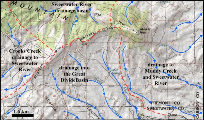
esr.ccsenet.org                                   Earth Science Research                               Vol. 9, No. 1; 2020

reason, Heller et al consider Sand Gap to have been the last Great Divide Basin outflow location. In contrast, the new
paradigm requires (unless there is good reason to believe otherwise) all gaps or low points along a drainage divide (also
referred to here as divide crossings) to have been eroded by water flowing in one direction or the other and the new
paradigm rule is the Missouri River drainage system developed as valleys eroded headward across immense south- and
southeast-oriented continental ice sheet meltwater floods (implying meltwater floods from a continental ice sheet once
flowed across the Great Divide Basin). This new paradigm defining rule is impossible from the accepted paradigm
perspective, meaning the two paradigms are fundamentally different.
Scientific paradigms according to Kuhn (1970) are frameworks of rules governing how a specific discipline conducts its
research and the paradigms by themselves are neither correct nor incorrect. A paradigm enables researchers to explain
evidence and to open up research opportunities, but also identifies anomalous evidence the paradigm rules cannot
satisfactorily explain. Kuhn suggests anomalous evidence is dealt with in one of three ways. First, the accepted
paradigm eventually explains the evidence and the paradigm continues without serious interruption. Second, the
anomalous evidence is shelved for future consideration. Third, the anomalous evidence leads to a new paradigm and a
battle over which paradigm should be used. In such a battle Kuhn suggests one paradigm should not judge the other, but
instead the competing paradigms should be evaluated based on their abilities to explain evidence.

  Figure 1. Modified imagery from United States Geological Survey (USGS) National Map website showing Great
 Divide Basin location and the east-west continental divide (dashed yellow line). Blue letters identify drainage routes:
BC-Bitter Creek, G-Green River, LS-Little Snake River, M- Muddy Creek, MB-Medicine Bow River, NP-North Platte
 River, S-Sweetwater River, SFP-South Fork Powder River, W-Wind River. Red letters identify mountains: C-Crooks
  Mountain, F-Ferris Mountain, G-Green Mountain, GM- Granite Mountains, L-Laramie Range, MB-Medicine Bow
                          Mountains, SM-Sierra Madre Mountains, WR-Wind River Range
Heller et al only mention four gaps or divide crossings, yet topographic maps show numerous other divide crossings
along continental divide segments now encircling the Great Divide Basin and these other divide crossings all link Great
Basin low areas (and sub-basins) with external drainage basins. Heller et al do not explain why only four divide
crossing are mentioned or why their paper for all practical purposes ignores three of those four mentioned divide
crossings, although it is possible the accepted paradigm rules do not permit satisfactory explanations for those other
divide crossings. This paper briefly describes several of the numerous divide crossings (including those in the Heller et
al paper) that are notched into continental divide segments encircling the Great Divide Basin and attempts to explain
those divide crossings from the accepted and the new paradigm perspectives. Finally, Occam‟s Razor, which in science

                                                           46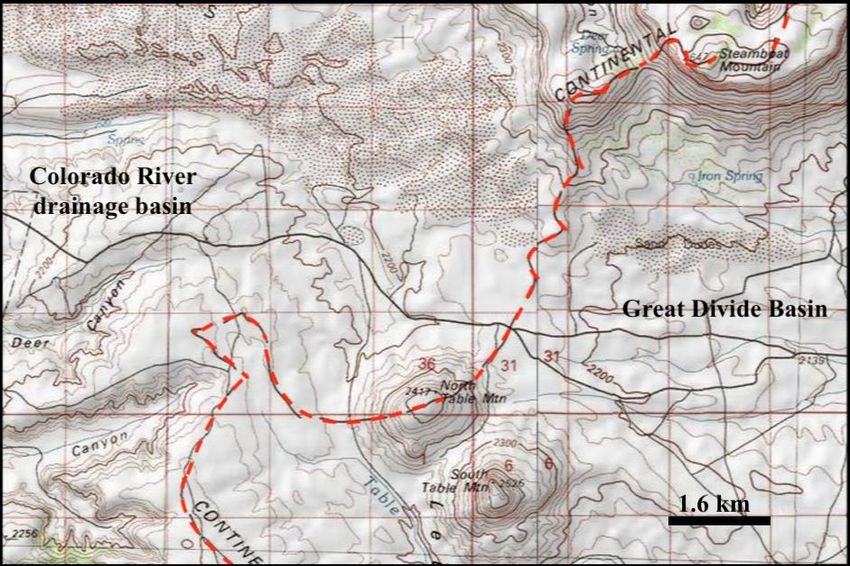
esr.ccsenet.org                                     Earth Science Research                                 Vol. 9, No. 1; 2020

according to Anderson (2002, p. 57) says “what can be done with fewer [assumptions] is done in vain with more,” is
used to compare the two fundamentally different paradigm explanations.
1.2 Geographic Setting
The previously mentioned figure 1 shows the Great Divide Basin location in relation to surrounding drainage routes and
mountain ranges (note the Wyoming border with Colorado and Utah near the bottom). The dashed yellow line shows
the east-west continental divide that follows the Wind River Mountains crest in a northwest-to-southeast direction
before splitting to encircle the Great Divide Basin and then to again become a single drainage divide along the Sierra
Madre Mountains crest. The Green River drainage basin with its water eventually reaching the Colorado River and the
Pacific Ocean is located to the west and south of the Great Divide Basin (the Little Snake River flows to the Yampa
River, which then flows to the Green River). The North Platte River is located to the east of the Great Divide Basin
where it flows in a north direction before turning in an east direction with its water eventually reaching the Missouri
River and ultimately the Gulf of Mexico. To the north of the Great Divide Basin is the narrow east-oriented Sweetwater
River drainage basin, which drains to the North Platte River, while further to the north the Wind River turns abruptly
from flowing in a southeast direction to flow in a north direction with its water eventually reaching the Missouri River
and water in the north-oriented South Fork Powder River also eventually reaches the Missouri River.
1.3 Previous Work
For paradigm comparisons previous work needs to be subdivided into three groups. The first group presents observed
evidence requiring explanations regardless of the paradigm used. Detailed topographic maps like those at the United
States Geological Survey (USGS) National Map website are examples of paradigm-neutral previous work. Geologic
maps, such as the Love and Christiansen (1985) Geologic Map of Wyoming, also record paradigm-neutral observations,
although paradigm-influenced interpretations are sometimes included. Further, published geologic reports contain
paradigm-neutral observations such as the Conroy et al (2008, p. 751) statement that the Great Divide Basin is
underlain by “a syncline with well over a thousand meters of mostly flat-lying sedimentary rocks of the Paleocene Fort
Union Formation and the Eocene Wasatch, Green River, and Bridger formations overlying Cretaceous rocks of the
Mesa Verde Group.” Steidtmann et al (1989, p. 39) also provide paradigm neutral evidence by observing that volcanic
clasts now found in “middle Eocene Bridger Formation” conglomerates that had been moved by a south-oriented
drainage system across what are now the high Wind River Mountains from the Absaroka volcanic field (in the north) to
what is now the upper Green River drainage basin.
Reports written from the accepted paradigm perspective represent a second previous work type. To explain how rivers
cut deep canyons across Wyoming mountain ranges a Mears (1993, p. 609) literature review says. “At the climax of the
Laramide orogeny, during the latest Paleocene and earliest Eocene, the relief of the mountains exceeded that of the
present. …in the early mid-Eocene, the crests of the mountains were lowered by erosion and the mountain valleys and
broad intermontane basins were filled. The basin deposits were partially excavated during a widespread late Eocene
interval of regional erosion that preceded the onset of renewed basin filling in the latest Eocene. During the ensuing
aggradation, clastic debris derived from the mountains was overwhelmed by ash from distant volcanic eruptions. The
rising level of Oligocene and then Miocene deposits eventually lapped across the lower segments of the
crystalline-cored uplands that finally had been eroded down to broad subsummit surfaces surmounted by residual hills
and peaks.” Following the filling of the intermontane basins and the near burial of the mountains Mears continues by
saying a broad regional uplift and exhumation of the broad basin floors began. Based on such an accepted paradigm
interpretation Lillegraven and Ostresh (1988, p. 320) determined that “Because of the extensive early Oligocene
infillings of Wyoming‟s basins, a basic eastwardly grained drainage pattern… was established” and include a map
showing early Oligocene east-oriented drainage routes crossing what is now the Great Divide Basin and flowing to an
ancestral north- and east-oriented North Platte River drainage route (roughly following its present-day alignment).
Many accepted paradigm interpretation details remain unknown. Flanagan and Montagne (1993, p. 597) state, “The
depth and timing of Wyoming‟s basin fill remains a controversial subject. The essential question is whether Wyoming‟s
foreland basins were filled with volumetrically more Cenozoic sedimentary material between late Eocene and
Pleistocene and then substantially excavated or whether the material in the basins today is the maximum sediment fill
deposited in the basins throughout the Cenozoic,” although they also say (p. 598) “The superposition of river systems
suggest that these rivers were flowing across basins filled with sedimentary material to elevations of approximately
9,000 ft. (2700 m).” Fan et al (2014, p. 547) suggest “When and how the central Rocky Mountains (Rockies) of western
North America gained modern topography remains a controversial question” and then suggest “the region underwent
differential uplift to form relief similar to that of today before earliest Oligocene time.” Heller et al (2010, p. 150) state
“during the early part of the Laramide orogeny, [the Great Divide] basin was part of the greater Green River Basin” and
that “The basin was not closed, however, until at least middle to late Miocene time.” They further suggest “closure of

                                                             47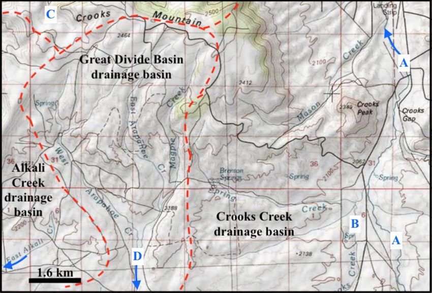
esr.ccsenet.org                                    Earth Science Research                                Vol. 9, No. 1; 2020

the Great Divide Basin took place with no internal faulting, nor did it require any extrabasinal tectonic activity to force
its closure.”
In spite of unanswered questions Hansen (1986, p. 67) suggests, “by late Eocene or early Oligocene time… Drainage
out of the Green River Basin was presumably eastward, across the present continental divide… The Great Divide Basin
rose so much in late Pliocene time that it was largely stripped of post-Eocene rocks (Love, 1971). As the eastern Uinta
Mountains subsided, moreover, the new drainage along and across the range gradually extended its watershed, and the
Upper Green River finally was captured near the present mouth of Bitter Creek.” Hansen further notes “late Tertiary and
Quaternary uplift of the Continental Divide across southern Wyoming probably was partly responsible for the Upper
Green‟s capture and diversion,” and (p. 69) “the capture may have been a middle Pleistocene event, although modern
indigenous fish species in the Upper Green River drainage differ markedly from those in the North Platte and
Sweetwater.” Hansen and Lillegraven and Ostresh do not address Love‟s (1970, p. C119) observation that a
south-oriented late Eocene “powerful river from the Absaroka Range continued to flow southeastward along the west
margin of the Granite Mountains and into the Great Divide basin” and that “Boulders of Tertiary igneous rocks as much
as 8 feet (2.4 m) in diameter were carried 90 miles (145 km) or more and deposited along the stream valley. The volume
of water and the stream velocity and gradient necessary to move boulders of this size a distance of 90 miles (145 km)
should be investigated further.”
The third type of previous work addresses the new paradigm and to date is limited to Clausen‟s 2017-2019 publications.
These publications define the new paradigm with a rule that says today‟s Missouri River drainage basin developed as
deep valleys eroded headward from the Mississippi River valley and from what was a continental ice sheet location
across and along immense south- and southeast-oriented floods. This definition (which from the accepted paradigm
perspective did not and could not have happened) forces recognition of a North American continental ice sheet thick
and heavy enough to create a deep “hole” by deeply eroding the bedrock under it and by causing crustal warping
elsewhere on the continent that raised what are now mountain ranges and high plateau areas as immense meltwater
floods flowed across them. Clausen (2019a and 2019b) states prior to drainage reversals that caused the melt water
floods to flow into deep “hole” space being opened up by ice sheet melting, south-oriented melt water floods flowed
across what is now the Bighorn-Wind River drainage divide and into the Wind River Basin and then southward across
the east-oriented Sweetwater River drainage basin and the Great Divide Basin to reach the Colorado River and the
Pacific Ocean. Several other recent papers demonstrate how the new paradigm explains previously unexplained
topographic map evidence for more than 15 specific northern Missouri River drainage basin geographic regions, some
of which are summarized in Clausen (2018a, 2018b, and 2019c), while other papers such as Clausen (2018c and 2019d)
demonstrate how the new paradigm explains previously unexplained mountain pass and valley origins.
2. Research Method
This paper is one of several being written to demonstrate how the new paradigm explains previously unexplained
detailed topographic map evidence. After more than 20 years investigating anomalous drainage evidence a decision was
made to spend three years (1999-2001) using map interpretation techniques to study large mosaics of detailed hard copy
USGS and Canadian Geological Survey topographic maps so as to systematically cover the entire Missouri River
drainage basin and several adjacent drainage basins to determine how all drainage divides between streams (shown on
the maps) originated. Conclusions reached during that Missouri River drainage basin landform origins research project
were unexpected and fundamentally different from anything in the published scientific literature, but could not easily be
demonstrated to skeptical reviewers. The first three-year investigation was repeated during the 2011-2013 time period
using National Geographic TOPO digital maps and software and more than 500 research notes in blog format now
describe origins for almost 4000 different Missouri River drainage basin drainage divides and can be found at
geomorphologyresearch.com.
New paradigm development relied on detailed topographic map interpretation to identify drainage divides and low
points (divide crossings) along those divides which are interpreted (unless there is good reason to believe otherwise) to
be places where water once crossed the divide. The low points typically link valleys now draining in different directions,
suggesting water in one of those valleys has reversed its flow direction. Detailed topographic maps are used to study
downstream areas to determine why flow in one valley was reversed. Frequently, but not always, the reversed flow
valley now drains to a deeper valley as a barbed tributary suggesting the deeper valley beheaded and captured flow that
had been once moving across the drainage divide. The large number of divide crossings (observable on detailed
topographic maps along most drainage divides) are then used to reconstruct former drainage routes, which almost
always suggest large complexes of diverging and converging channels once crossed the studied drainage divides. The
diverging and converging channels are next interpreted to be flood formed anastomosing channel complexes, which can
be followed both downstream and upstream (using divide crossings and stream capture evidence observable on detailed
topographic maps). Detailed topographic maps of mountainous and high plateau areas when studied using such map

                                                            48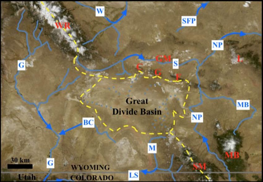
esr.ccsenet.org                                   Earth Science Research                               Vol. 9, No. 1; 2020

interpretation techniques provide good evidence that the mountains and plateau areas must have been rising as the
floodwaters flowed across them, which caused the floodwaters to be systematically diverted to flow in different
directions.
Research related to the project reported here used detailed topographic maps and tools available at the USGS National
Map website. Drainage divides surrounding the Great Divide Basin were identified and studied to locate gaps or divide
crossings where water flowing in one direction or the other had once crossed into and/or out of the Great Divide Basin.
Detailed topographic maps covering Great Divide Basin interior regions were also studied to identify pathways across
what are now shallow closed basins within the Great Divide Basin that might have served as flow routes for water
moving between various sets of divide crossings. Previous investigator published reports were reviewed to search for
references identifying any of the observed divide crossings and any discussions related to the origins of those mentioned
divide crossings. Published literature was also reviewed to note references suggesting that drainage routes once flowed
into and/or out of what is now the Great Divide Basin and the suggested directions and routes of flow. While the
reviewed literature only mentioned a few gaps or divide crossings the map study observed numerous divide crossings,
far too many to describe in this finite paper. What were regarded to be the most significant divide crossings (including
all divide crossings or gaps mentioned in the reviewed literature) were then briefly described in the results section
below. Accompanying those descriptions are attempts to explain the described divide crossings first from the accepted
paradigm perspective (using previous investigator interpretations if available) and second from the new paradigm
perspective (also based on published literature information if available).
3. Results
3.1 Divide Crossings Along the Great Divide Basin’s Northern Margin
The Great Divide Basin is bounded on the north (from the northwest to the southeast) by Crooks Mountain, Sheep
Mountain (a relatively small upland), Green Mountain, and the Ferris Mountains with the Seminoe Mountains
(unlabeled in figure 1) located to the east of Ferris Mountain. Alkali Creek is the north-oriented Sweetwater River
tributary shown in figure 1 (but unlabeled) to the west of Crooks Mountain and flows from the Great Divide Basin
northern margin in the wide gap between the Wind River Mountains and Crooks Mountain. Cyclone Rim is an arcuate
shaped ridge with elevations ranging from about 2140 to 2240 meters that for a distance of more than 10 kilometers
forms the low drainage divide between northeast-oriented West Alkali Creek and south-oriented drainage routes leading
into the Great Divide Basin. Northeast-oriented East Alkali Creek drains the south slope of the western two-thirds of
Crooks Mountain with low points along the East Alkali Creek-Great Divide Basin drainage divide being in the
2170-meter range. High points at the east end of Crooks Mountain seen in figure 2 exceed 2500 meters, but further to
the west several deep divide crossings notched into the Crooks Mountain upland have floor elevations in the 2230- to
2280-meter range. Arapahoe Creek headwaters (seen in figure 2) originate on the south side of the Crooks Mountain
highest ridges and Arapahoe Creek is a south-oriented stream flowing into the Great Divide Basin‟s Lost Creek Basin,
which is a shallow Great Divide Basin closed basin, while the north side of the Arapahoe Creek headwaters (and the
Crooks Mountain highest points) is drained by several north-oriented Sweetwater River tributaries.
Crooks Creek is the north-oriented Sweetwater River tributary flowing through Crooks Gap (seen in figure 2) and
drains the western two-thirds of the Green Mountain southwest slope and small areas along the Crooks Mountain south
and east flanks. A 100-meter deep divide crossing is located between Sheep Mountain and Green Mountain. Crooks
Creek originates as a south-oriented stream near the Green Mountain southeast end (see figure 3) and flows in a north
direction between Crooks Mountain and Sheep Mountain after flowing in a northwest direction along the Green
Mountain southwest flank where southwest-oriented tributaries draining much of the Green Mountain southwest slope
join it. Elevations along the West Fork Crooks Creek-Arapahoe Creek drainage divide (seen in figure 2) are as low as
2130 meters while elevations along the Sweetwater River-Arapahoe Creek drainage divide rise to more than 2500
meters and further to the east and southeast elevations at the Green Mountain southeast end (seen in figure 3) along the
Sweetwater River-Great Divide basin drainage rise to 2812 meters at Whiskey Peak (at the Green Mountain southeast
end). North-oriented Muddy Creek flows between Green Mountain and the Ferris Mountains and like Crooks Creek
flows from the Great Divide Basin northern margin with south-oriented tributaries draining the Green Mountain eastern
end and much of the Ferris Mountains southwest slope. Further to the east south-oriented streams drain a section of the
Ferris Mountains south flank directly into the Great Divide Basin while southeast-oriented Sand Creek headwaters drain
the eastern end of the Ferris Mountains south slope and then turn to flow in a north direction.
Previous investigators working from the accepted paradigm perspective have not addressed how drainage systems in the
Sweetwater River-Great Divide Basin drainage divide area originated. For example, Jaworowski (1991, p 417) states
“tributaries to the Sweetwater River flowed northward from Green Mountain during Quaternary time” but makes no
mention of how those drainage routes originated. Rackley (1972, p. 756), who was most interested in the regional

                                                           49
esr.ccsenet.org Earth Science Research Vol. 9, No. 1; 2020
uranium deposits states “With renewed uplift in early Eocene time… an apron of alluvial fans spread southward into the
Great Divide basin” in the area to the south of Crooks Gap (between Crooks Mountain and Green Mountain) and of
Muddy Gap (between Green Mountain and the Ferris Mountains), but makes no mention of how the present-day
north-oriented Alkali, Crooks, Muddy, and Sand Creek drainage systems evolved. Heller et al (2010, p. 150-2) while
mentioning, but not discussing Muddy Gap and two other gaps consider the Sand Creek drainage route to have been the
last Great Divide Basin outlet and state “Continued erosion in the surrounding drainage led to flexural rebound, against
which erosion by the outlet from the Great Divide Basin was unable to compete,” but do not explain how the present
day Alkali, Crooks, Muddy Creek drainage systems originated. These and other investigators ignored most of the
Sweetwater River-Great Divide Basin drainage divide area gaps or divide crossings, perhaps because the accepted
paradigm provides no good way to determine how the large numbers of gaps or divide crossings originated.
Figure 2. Modified topographic map from USGS National Map website showing drainage routes at and near tCrooks
Mountain southeastern end. Letters identify: A-north-oriented Crooks Creek, B-West Fork Crooks Creek, C-area
drained by north- and northeast-oriented Sweetwater River tributaries, D-Arapahoe Creek draining into Great Divide
Basin. Unlabeled blue arrow in southwest corner shows East Alkali Creek headwaters. Contour interval is 20 meters
In contrast Clausen (2019b), who worked from the new paradigm perspective, described topographic map evidence
showing where immense south-oriented floods had once crossed the present-day Wind River-Sweetwater River
drainage divide and includes the statement (p. 410) “the east-oriented Sweetwater River drainage basin is located along
a deep „hole‟ rim segment, with the deep „hole‟ rim in Montana, Wyoming, and northern Colorado following the
present-day east-west continental divide” and (p. 417) “deep „hole‟ rim uplift enabled the shallow east- and
northeast-oriented Sweetwater River valley to erode headward across the south-oriented flood flow channels and caused
flow reversals on north ends of the beheaded channels to create north-oriented Sweetwater River tributaries and the
Sweetwater River-Great Divide Basin drainage divide.” Such a scenario explains the above described topographic map
evidence including the water gaps, wind gaps, drainage routes, and drainage divides. The Alkali, Crooks, Muddy, and
Sand Creek drainage systems seen today originated when uplift of the Sweetwater River-Great Divide Basin drainage
divide area enabled the Sweetwater River valley to erode headward across the south-oriented flood flow and forced the
beheaded south-oriented flood flow channels that had been moving water into what is now the Great Divide Basin to
reverse their flow direction and to create what are today north-oriented Sweetwater River tributaries with south-oriented
headwaters and tributaries.
50esr.ccsenet.org Earth Science Research Vol. 9, No. 1; 2020
3.2 Divide Crossings Along the Great Divide Basin’s Eastern Margin
At the north end of the Great Divide Basin‟s eastern margin Sand Creek after originating as a southeast-oriented stream
turns and flows in a north direction through a 300-meter deep canyon separating the Ferris Mountains southeast end
from Bear Mountain (to the east) and then turns in a northeast direction to join the North Platte River. A somewhat
wider and dry southwest-to-northeast oriented valley, almost as deep, separates Bear Mountain from Junk Hill along
with other less deep divide crossings in the Seminoe Mountains also link the Great Divide Basin with northeast-oriented
North Platte River tributaries. Further to the south Windy Ridge, Cheyenne Ridge, and Coal Creek Rim form
zig-zagging hogback ridges that roughly follow the Great Divide Basin-North Platte River drainage divide and link the
Seminoe Mountains with the Haystack Mountains. Divide crossings notched into these ridges also suggest water once
flowed across the Great Divide Basin-North Platte River drainage divide. The deepest of these divide crossings is cut
across Coal Creek Rim and has almost the same floor elevation as Sand Creek Gap (about 2100 m). Still further to the
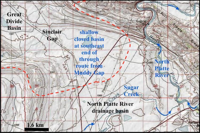
south Sinclair Gap (seen in figure 4) is located near the south end of a broad flat-floored and roughly north-northwest to
south-southeast oriented structural valley between the Haystack Mountains (east) and the Rawlins Uplift (west) that
links Separation Flats in the Great Divide Basin (to the north) with the north-oriented North Platte River valley.
Separation Lake (in a Separation Flats area extending southward between the Rawlins Uplift and the Haystack
Mountains) is near the south-southeast end of a series of shallow closed basins extending from figure 3 to Sinclair Gap.
Great Divide Basin drainage routes seen in figure 3, if they had sufficient volumes of water, would flow across the
Great Divide Basin‟s eastern margin in a south-southeast direction to Sinclair Gap and then to the North Platte River.
Based on present-day floor elevations Sinclair Gap (1996 m) is the lowest point on drainage divides surrounding the
Great Divide Basin (although Heller et al say the bedrock channel under Sand Creek Gap area sand dunes is 6 meters
lower).
Figure 3. Modified USGS topographic map showing major drainage divides (dashed red lines) in the Green Mountain
southeast end area. Blue lines and arrows show major drainage routes and directions. Contour interval is 20 meters
Within the Great Divide Basin Separation Creek begins as a southwest-oriented stream on a Cretaceous Lance
Formation surface near the south end of Great Divide Basin‟s eastern margin (McLaughlin and Fruhwirth, 2008) and
then makes a U-turn to flow in a north direction on a route west of the Great Divide Basin‟s eastern margin and along
the Rawlins Uplift west side before cutting across dipping Tertiary and Cretaceous stratigraphic units and making a
U-turn to flow around the Rawlins Uplift north end and then in a south direction between the Rawlins Uplift and
Haystack Mountains to end at Separation Lake (in a shallow closed basin about 15 kilometers to the northwest of figure
51esr.ccsenet.org Earth Science Research Vol. 9, No. 1; 2020
4). A well-defined 200-meter deep dry valley (floor elevation slightly less than 2200 meters) links the south end of the
north-oriented Separation Creek valley with south-oriented Alamosa Gulch draining to Muddy Creek in the Colorado
River drainage basin and suggests water once flowed in one direction or the other between the present-day Colorado
River drainage basin and the Great Divide Basin. Further to the north the City of Rawlins is located on the north side of
a well-defined west-to-east oriented divide crossing linking the Great Divide Basin‟s Separation Creek drainage basin
with east-oriented Sugar Creek flowing to the North Platte River (seen in figure 4). The Rawlins divide crossing has a
floor elevation of slightly more than 2110 meters and suggests possible erosion by east- or west-oriented anastomosing
channels. Today that divide crossing is used as a major east-to-west highway, railroad, and pipeline route. Other Great
Divide Basin eastern margin divide crossings, most with higher floor elevations are too numerous to discuss and
suggest multiple streams of water once flowed between the Separation Creek drainage basin (in the Great Divide Basin)
and the North Platte River drainage basin (now draining to the Gulf of Mexico).
Figure 4. Modified topographic map from the USGS National Map website showing Sinclair Gap between the Rawlins
Uplift (southwest) and the Haystack Mountains (north) and the north-oriented North Platte River water gap cutting
between the Haystack Mountains (west) and the Fort Steele Breaks (east). Red dashed line shows Great Divide
Basin-North Platte River drainage divide. Contour interval is 20 m
Heller et al (2010), who worked from the accepted paradigm perspective considered Sand Creek Gap to be where water
last exited the Great Divide Basin and other than briefly mentioning Sinclair Gap did not discuss other divide crossings
linking the Great Divide Basin and North Platte River drainage basin. Perhaps this failure was based on an
interpretation by several previous investigators that the Green River had once flowed across the Great Divide Basin in
an eastward direction to reach the North Platte River. If so, while not stated Heller et al may have sought to determine
where the Green River exited the Great Divide Basin and may have considered Sand Creek Gap the most likely location.
However, Sand Creek Gap is not the only divide crossing leading from the Great Divide Basin to the North Platte River
drainage basin. Each of the many other divide crossings is a place where water once flowed in one direction or the other.
If an east-oriented Green River eroded Sand Creek Gap then what other drainage routes eroded divide crossings at Coal
Creek Rim, at Sinclair Gap, or at Rawlins? And the problem gets more complex when the many other eastern margin
gaps, such as the dry valley between Bear Mountain and Junk Hill and the Separation Creek-Alamosa Gulch through
52esr.ccsenet.org Earth Science Research Vol. 9, No. 1; 2020
valley are included. The accepted paradigm does not permit reconstructions of the multitude of drainage routes that gaps
along the Great Divide Basin eastern margin indicate once moved water into or out of the Great Divide Basin.
In contrast the new paradigm requires massive south-oriented floods to have flowed across the entire Missouri River
drainage basin as crustal warping raised what are now high plateau areas and mountain ranges. The North Platte River is
included in the Missouri River drainage basin and the new paradigm requirement forces recognition that the present-day
north-oriented North Platte River segment to the east of the Great Divide Basin developed when crustal warping forced
a reversal of flow on what had been a major south-oriented flood flow route. The new paradigm requirement also forces
recognition that what are today northeast-oriented North Platte River tributaries were formed by reversals of
southwest-oriented anastomosing flood flow channels that had been moving water from what is today the North Platte
River drainage basin into what is now the Great Divide Basin. South-oriented floodwaters moving across the Great
Divide Basin‟s eastern area would have logically flowed through Sinclair Gap from what is now the Great Divide Basin
to reach south-oriented flood flow moving on what is now the north-oriented North Platte River alignment (which prior
to its reversal had been moving water across what are now high mountain passes to the Colorado River drainage basin
and to the Laramie and Cache la Poudre Rivers) or in the Separation Creek-Alamosa Gulch through valley to reach the
Colorado River drainage basin.
3.3 Divide Crossings Along the Great Divide Basin’s Southern Margin
Fillmore Creek begins at the Great Divide Basin southern margin‟s eastern end almost in the Separation Creek-Alamosa
Gulch through valley and flows in a northwest and west direction before turning in a north and northeast direction to
join Separation Creek. Several well-defined divide crossings suggest streams of water once flowed across the Fillmore
Creek-Muddy Creek (Great Divide Basin-Colorado River drainage basin) divide. One deeper divide crossing (floor
elevation 2193) has a depth of approximately 35 meters and like the other divide crossings links north- and
south-oriented valleys. To the west of the Fillmore Creek drainage area elevations along the Great Divide
Basin-Colorado River drainage divide decrease and are generally less than 2100 meters with elevations in the
Wamsutter Gap area decreasing to 2051 meters before rising to more than 2100 meters along the Wamsutter Rim crest.
To the west of the Wamsutter Gap area the Great Divide Basin-Colorado River drainage divide is located to the north of
the northwest- and southwest-oriented Bitter Creek drainage basin with Bitter Creek flowing to the south-oriented
Green River (which flows to the Colorado River). Interestingly a 7-kilometer long segment of this Great Divide
Basin-Bitter Creek (Colorado River) drainage divide stretch has elevations lower than 2100-meters, with the lowest
elevation being about 2080 meters. Elevations along the Great Divide Basin‟s southern margin are remarkably similar to
floor elevations of divide crossings along the Great Divide Basin‟s northern and eastern margins and if south-oriented
Arapahoe Creek (seen in figure 2) had sufficient volumes of water that water after filling some shallow closed basins
could easily overflow and continue in a south direction across the Great Divide Basin to reach many of the Great Divide
Basin southern margin divide crossings and the Colorado River drainage basin.
In spite of Love‟s (1970) suggestion that a powerful south-oriented river entered the Great Divide Basin and suggestion
that further investigation should be conducted subsequent investigators working from the accepted paradigm
perspective have not described where that powerful river went. Hansen (1986) describes an east-oriented Green River,
but makes no mention of a powerful south-oriented river and does not show how Great Divide Basin topographic map
evidence supports such an interpretation and also ignores the Great Divide Basin south margin topographic map
evidence. Heller et al (2010) reference Love‟s 1970 paper, but do not mention a powerful south-oriented river that once
entered what is now the Great Divide Basin. Love‟s powerful south-oriented river must have flowed completely across
the Great Divide Basin probably to reach the Colorado River drainage basin. Further, while briefly mentioning
Wamsutter Gap Heller et al do not discuss how any Great Divide Basin southern margin divide crossings originated.
Trying to use previously published interpretations to explain the Great Divide Basin southern margin divide crossing
evidence suggests researchers working from the accepted paradigm perspective have yet to ask the correct questions,
which are where did that powerful south-oriented river come from, where did it flow across the Great Divide Basin and
where did it exit from the Great Divide Basin?
The new paradigm requires immense south-oriented floods to have crossed the entire Missouri River drainage basin,
which includes what is today the east-oriented Sweetwater River drainage basin and such floods must have flowed into
and across the Great Divide Basin. Such a requirement forces recognition that the Great Divide Basin is located along a
deep “hole” rim segment formed by continental ice sheet caused crustal warping that occurred as massive
south-oriented floods flowed from the continental ice sheet to and across what is now the Montana, Wyoming, and
northern Colorado east-west continental divide. Uplift of that deep “hole” rim segment would have enabled the
east-oriented Sweetwater River valley to erode headward across south-oriented floodwaters so as to divert flood flow
along the rising deep “hole” rim in an eastward direction. At first the newly diverted east-oriented floodwaters would
have joined south-oriented flood flow on what is today the north-oriented North Platte River alignment (note in figure 1
53esr.ccsenet.org Earth Science Research Vol. 9, No. 1; 2020
how the Sweetwater River turns in a south direction to join the North Platte River), but as deep “hole” rim uplift
proceeded flood flow on the North Platte River alignment would have been reversed to form today‟s north-oriented
North Platte River. Assuming prior to Sweetwater River valley headward erosion south-oriented floodwaters moved in
complexes of diverging and converging channels into and across the Great Divide Basin all divide crossings along the
Great Divide Basin‟s southern margin, just like those along the northern and eastern margins, can be easily explained.
3.4 Divide Crossings Along the Great Divide Basin’s Western Margin
Divide crossing floor elevations along the Great Divide Basin‟s western margin are generally higher than lowest divide
crossing floor elevations along the northern, eastern, and southern margins, and like the north, east, and south margins
the Great Divide Basin‟s western margin has more divide crossings than this finite paper can address. However, divide
crossings located near the western margin‟s south end in the Leucite Hills area (figure 5) merit attention. The Leucite
Hills are located on the Rock Springs uplift‟s north flank and are eroded remnants of a “Pliocene-Pleistocene” volcanic
field. Note how the Colorado River-Great Divide Basin drainage divide (shown by red dashed line) crosses North Table
Mountain before dropping in elevation as it crosses a 200-meter deep divide crossing to then cross the top of Steamboat
Mountain. Maps by Scott and Jones (2009) and Hallberg and Case (2015) show Steamboat Mountain and North Table
Mountain and South Table Mountain to have a volcanic caprock overlying Tertiary sediments. Drainage on the west
side of the continental divide flows to south-oriented Killpecker Creek, which joins southwest-oriented Bitter Creek
shortly before Bitter Creek joins the south-oriented Green River (which then flows to the Colorado River). The
Killpecker Creek valley floor to the west of figure 5 has approximately the same elevation (about 2020 meters) as the
floor of the shallow Great Divide Basin closed basin where the east-oriented drainage routes end.
Figure 5. Modified topographic map from the USGS National Map website showing the continental divide location (red
dashed line) and the 200-meter deep divide crossing between North Table Mountain and Steamboat Mountain. West-
and southwest-oriented drainage flows to south-oriented Killpecker Creek, which flows to Bitter Creek and then to
south-oriented Green River. The contour interval is 20 meters
Working from the accepted paradigm perspective Lange et al (2000, p. 329) state Leucite Hills “volcanic activity
spanned the interval from 3.0 to 0.89 Ma” and “there is a strong correlation… between the height of the volcanic mesas
(the volcanic cap protects the underlying sediment from erosion) and their eruption age, providing an average sediment
54esr.ccsenet.org Earth Science Research Vol. 9, No. 1; 2020
erosion rate of about 0.113 mm/year over the last 2.5 million years.” They determined ages for Steamboat Mountain
caprock of about 1.8 Ma, North Table Mountain caprock of about 1.4 MA, and South Table Mountain caprock of about
2.5 or 1.8 MA. These ages imply that about two million years ago Tertiary sediments capped by volcanic rocks
extended across the entire figure 5 map area to a level as high as the North Table Mountain and Steamboat Mountain
tops and may have extended westward across what is now the Killpecker Creek valley and eastward into and possibly
across what is now the Great Divide Basin. Such basin fill is consistent with previously discussed accepted paradigm
interpretations, although other than providing an erosion rate the Lange et al paper provides no clue as to how the gap
between North Table and Steamboat Mountains was eroded or as to how the Killpecker Valley or the Great Divide
Basin to the east were eroded. On the other hand, working from the new paradigm perspective Clausen (2019b)
described how massive south-oriented floods eroded Sweetwater Gap (and other gaps) across a rising Wind River
Range (to the north of the figure 5). Such floods could easily have reached the figure 5 map area with one diverging
channel flowing between North Table and Steamboat Mountains while the main channel continued southward along the
Killpecker Creek alignment. Headward erosion of the deep Killpecker Creek valley eventually would have captured all
east- and southeast-oriented flow moving around North and South Table Mountains into what is now the Great Divide
Basin and that capture would have created the present-day drainage divide.
4. Discussion and Conclusion
This paper describes enough divide crossings notched into drainage divides encircling the Great Divide Basin interior
drainage region to demonstrate that water once flowed at numerous locations into and/or out of the Great Divide Basin.
For some reason previous investigators working from the accepted paradigm perspective have failed to mention and
discuss almost all of the described divide crossings. It is possible accepted paradigm rules focus investigator attention
on other types of evidence and cause investigators to ignore drainage divides and places where water once flowed
across those drainage divides. Rather than studying drainage divides and divide crossings several previous investigators
focused their attention on a hypothesized east-oriented Green River, yet those previous investigators have not
demonstrated where the Green River entered and/or exited the Great Divide Basin nor have they documented where the
Green River flowed across the Great Divide Basin. Today the Green River heads in the Wind River Mountains (see
figure 1) and flows in a south direction across the Green River Basin to reach Utah and then enter deep canyons as it
flows across the eastern Uinta Mountains uplift. Any hypothesis suggesting the Green River once flowed across the
Great Divide Basin also requires a good explanation of how a valley could erode headward across the high Uinta
Mountains uplift and capture an east-oriented Green River. To date no such explanation has been offered. At best the
accepted paradigm explanations are incomplete and do not explain the easy to observe erosional landform evidence.
Unlike the accepted paradigm the new paradigm by recognizing the Great Divide Basin and adjacent mountain ranges
were uplifted at the same time that immense south-oriented floods flowed across the Rocky Mountains successfully
explains most if not all observed drainage divide and divide crossing origins and as such provides much simpler
drainage divide and divide crossing origin explanations than the accepted paradigm. However, new paradigm
explanations also raise questions such as, where did the floodwaters come from and why were the floodwaters flowing
across what is today the east-west continental divide at a time when that continental divide and the adjacent mountain
ranges were being uplifted? The new paradigm definition (that all Missouri River drainage basin valleys eroded
headward across immense south-oriented floods) forces recognition of a continental ice sheet that was heavy enough to
cause significant crustal warping and to create and occupy a deep “hole” and also forces recognition that the North
American east-west continental divide in Montana, Wyoming, and northern Colorado (which today is a Missouri River
drainage basin drainage divide segment) originated as a deep “hole” rim segment. Meltwater floods from such a
continental ice sheet would have flowed in south directions across the rising deep “hole” rim until rim uplift forced the
floodwaters to first flow in an east direction (enabling the east-oriented Sweetwater River valley to capture the
floodwaters by eroding headward across the south-oriented flood flow channels) and then forced massive reversals of
the south-oriented flood flow back toward the ice sheet margin (e.g. see the Wind River direction change in figure 1).
But such explanations lead to a fundamentally different middle and late Cenozoic regional geologic history than what
previous investigators working from the accepted paradigm perspective have described.
Without question the new paradigm provides simpler explanations for the erosional landform features discussed here
and based on Occam‟s Razor should be the preferred paradigm. However, the new paradigm success demonstrated here
relates only to erosional landform evidence found in one geographic region. Other types of geologic evidence in other
geographic regions led previous investigators (who used the accepted paradigm perspective) to describe a completely
different middle and late Cenozoic regional geologic history than what the new paradigm interpretations discussed here
suggest occurred. The new paradigm success in explaining those other types of geologic evidence has yet to be
demonstrated, just as the accepted paradigm has yet to demonstrate its ability to satisfactorily explain erosional
landform evidence of the type described here. While additional new and accepted paradigm testing is needed
55esr.ccsenet.org Earth Science Research Vol. 9, No. 1; 2020
investigators should be aware the new paradigm can explain significant erosional landform evidence that to date the
accepted paradigm has yet to satisfactorily explain.
Acknowledgements
Arthur Strahler, then at Columbia University, and Brainerd Mears, Jr., then at the University of Wyoming during the
mid 1960s introduced the author to numerous unsolved drainage history problems. Preliminary work leading up to the
new paradigm development was done while employed as a faculty member at Minot State University (North Dakota)
where other faculty members, students, and library staff members helped to provide access to many thousands of
hard-copy detailed topographic maps.
References
Anderson, D. L. (2002). Occam‟s razor: simplicity, complexity, and global dynamics. Proceeding of the American
Philosophical Society, 146(1), 57.
Clausen, E. (2018a). Deep erosion by continental ice sheets: a northern Missouri River drainage basin perspective,
North America. Current Research in Geoscience, 8, 27-38. https://doi.org/10.3844/ajgsp.2018.27.38
Clausen, E. (2018b). Geomorphic history of the Beaver Creek drainage basin as determined from topographic map
evidence: eastern Montana and western North Dakota, USA. Journal of Geography and Geology, 10(3), 79-91.
https://doi.org/10.5539/jgg.v10n3p79
Clausen, E. (2018c). Topographic map analysis of high elevation Black Hills through valleys linking Spearfish and
Rapid Creek headwaters valleys, Lawrence County, South Dakota, USA. Journal of Geography and Geology,
10(1), 8-21. https://doi.org/10.5539/jgg.v10n1p8
Clausen, E. (2019a). Topographic map interpretation of Bighorn River-Wind River drainage divide located east of
Wyoming‟s Wind River Canyon, USA. Universal Journal of Geoscience, 7(2), 56-67.
https://doi.org/10.13189/ujg.2019.070202
Clausen, E. (2019b). Use of topographic map evidence to test a recently proposed regional geomorphology paradigm:
Wind River-Sweetwater River drainage divide area, Central Wyoming, USA. Open Journal of Geology, 9, 404-423.
https://doi.org/10.4236/ojg.2019.98027
Clausen, E. (2019c). How a fundamentally different and new glacial history paradigm explains North America glaciated
prairie region erosional escarpments and drainage patterns. Earth Science Research, 8(2), 23-34.
https://doi.org/10.5539/esr.v8n2p23
Clausen, E. (2019d). Use of stream and dismembered stream valleys now crossing Wyoming‟s northern Laramie
Mountains to test a recently proposed regional geomorphology paradigm, USA. Open Journal of Geology, 9,
731-751. https://doi.org/10.4236/ojg.2019.98027
Conroy, G. C., Anemone, R. L., Van Regenmorter, J., & Addison, A. (2008). Google Earth, GIS, and the Great Divide:
a new and simple method for sharing paleontological data. Journal of human evolution, 55(4), 751.
https://doi.org/10.1016/j.jhevol.2008.03.001
Fan, M., Heller, P., Allen, S. D., & Hough, B. G. (2014). Middle Cenozoic uplift and concomitant drying in the central
Rock Mountains and adjacent Great Plains. Geology, 42(6), 547-550. https://doi.org/10.1130/G35444.1
Flanagan, K. M., & Montagne, J. (1993). Neogene stratigraphy and tectonics of Wyoming. In Snoke, A. W., Steidtmann,
J. R., and Roberts, S. M. (eds) Geology of Wyoming. Geological Survey of Wyoming Memoir, 5, 597-598
Hallberg, L. L., & Case, J. C. (2015). Preliminary surficial photogeologic map of the Red Desert Basin 30‟ x 60‟
quadrangle, Sweetwater County, Wyoming. Wyoming State Geologic Survey, Open File Report 15-4, scale
1:100,000. https://doi.org/10.3133/ofr72309
Hansen, W. R. (1986). Neogene tectonics and geomorphology of the eastern Uinta Mountains in Utah, Colorado, and
Wyoming. United States Geological Survey, Professional Paper;(USA), 75(1356). https://doi.org/10.3133/pp1356
Heller, P. L., McMillan, M. E., & Humphrey, N. (2010). Climate-induced formation of a closed basin: Great Divide
Basin, Wyoming. Geological Society of America Bulletin, 123(1-2), 150-157. https://doi.org/10.1130/B30113.1
Jaworowski, C. (1991). Green Mountain-Sweetwater River area. In Morrison, R. B. (Ed), Quaternary nonglacial
geology: conterminous U.S. volume K-2. Geological Society of America, 417-418.
Kuhn, T. S. (2012). The structure of scientific revolutions. University of Chicago press.
Lange, R. A., Carmichael, I. S. E., & Hall, C. M. (2000). 40Ar/39Ar chronology of the Leucite Hills, Wyoming: eruption
rates, erosion rates, and an evolving temperature structure of the underlying mantle. Earth and Planetary Science
56esr.ccsenet.org Earth Science Research Vol. 9, No. 1; 2020
Letters, 174(3-4), 329-340. https://doi.org/10.1016/S0012-821X(00)00093-5
Lillegraven, J. A., & Ostrech, L. M. Jr. (1988). Evolution of Wyoming‟s early Cenozoic topography and drainage
patterns. National Geographic Research, 4, 303-327.
Love, J. D. (1970). Cenozoic geology of the Granite Mountains area, central Wyoming (No. 495-C).
https://doi.org/10.3133/pp495C
Love, J. D. (1971). Relation of Cenozoic geologic events in the Granite Mountains area, central Wyoming, to economic
deposits, In Symposium on Wyoming tectonics and their economic significance. Wyoming Geological Association
Guidebook, 23rd Annual Field Conference, 71-80. https://doi.org/10.3133/pp495C
Love, J. D., & Christiansen, A. C. (1985). Geologic map of Wyoming. United States Geologic Survey, Wyoming State
Geological Survey 2014 release.
McLaughlin, J. F., & Fruhwirth, J. (2008). Preliminary geologic map of the Rawlins 30‟ x 60‟ quadrangle, Carbon and
Sweetwater Counties, southeastern Wyoming. Wyoming Geological Survey, Open File Report OFR 08-4, scale
1:100,000. https://doi.org/10.3133/ofr74179
Mears Jr, B. (1993). Geomorphic history of Wyoming and high-level erosion surfaces. Geology of Wyoming: Laramie,
Geological Survey of Wyoming Memoir, 5, 608-626.
Rackley, R. I. (1972). Environment of Wyoming Tertiary uranium deposits. American Association of Petroleum
Geologists Bulletin, 56(4), 755-774. https://doi.org/10.1306/819A4080-16C5-11D7-8645000102C1865D
Scott, J. E., & Jones, R. W. (2009). Preliminary geologic map of the Rock Springs Quadrangle, Wyoming Geological
Survey, Open File Report 09-4, scale 1:100,000. https://doi.org/10.3133/ofr76229
Steidtmann, J. R., Middleton, L. T., & Shuster, M. W. (1989). Post Laramide (Oligocene) uplift in the Wind River
Range, Wyoming. Geology, 17(1), 38-41. https://doi.org/10.1130/0091-7613(1989)0172.3.CO;2
Copyrights
Copyright for this article is retained by the author(s), with first publication rights granted to the journal.
This is an open-access article distributed under the terms and conditions of the Creative Commons Attribution license
(http://creativecommons.org/licenses/by/4.0/).
57You can also read