2021 Atikokan Crown Land Route Book - Northern Tier
←
→
Page content transcription
If your browser does not render page correctly, please read the page content below
2021 Atikokan Crown Land Route Book
        You are receiving this document because your crew has chosen to paddle in the Crown Lands or you are a
crew of 9 to 11 people which can only travel in the Crown Lands. The Ontario Ministry of Natural Resources
requires a route selection well in advance of your trip. You must select your preferred route by the day your
final payment is due so that we may submit it to the Ministry of Natural Resources (MNR) with enough
notice for your trip.

       Canada is comprised of 89% Crown Land. It is all un-owned land, coast to coast in Canada. Locals refer
to the area we paddle simply as “the Bush.”

        The routes in this document allow us to better accommodate your crew and give our Interpreters a
general idea of where you want to travel so they may plan accordingly. Please review this document with
your crew and make your route selection. When you arrive at the Atikokan base, your crew and Interpreter will
have time to decide the specifics of your trip ranging from daily distances, where you’ll camp each night, and
options to extend or shorten certain sections of your route. While the exact route may have some flexibility,
assigned entry points and exit points will not change and major route edits must be pre-approved.

        The day length in each section is to be used as a guideline. They do not need to be strictly adhered
to. For example, if your crew wants to paddle more distance, they can select a route that suggests more days. If
your crew would prefer to spend more time fishing or take a layover day, they can pick a route that would
require fewer days to complete. The average Northern Tier crew covers around 10-15 miles per day.

        Weather and water levels in our area are constantly changing. Winter storms, aggressive beavers, human
activity, and nearby dam levels all prevent us from guaranteeing “easy”, “medium”, or “hard” rating for each
route. Unforeseen early or late season environmental hazards may exist which could add to the level of
difficulty. Because data for each trip was gathered from previous summers, “Difficulty” and “Distance” are
approximations and may be different for your crew. Unfortunately, we are unable to provide exac t number of
portages. Route lines on the maps are approximations and are not to be used for navigation. Northern Tier
may need to amend the following routes based on known trail conditions of the current season.

        To manage and rehabilitate the Canadian Crown Lands, the Ministry of Natural Resources has limited
camping in an area called the “Green Zone”. Your crew is welcome to continue fishing and travelling while in
these sections, but camping is not permitted. The Green Zone has been grayed out in the following route
thumbnails.

        After selecting a route, the staff at Northern Tier will confirm that the itinerary you chose will work with
your length of stay and will communicate with you if they feel you have chosen a route that isn’t suitable for
your trip length

       Please select your first and second choices by following the instructions in the email. Sister crews cannot
select the same two routes.

       If your crew has chartered a float plane for you trip, please contact Northern Tier after you have
selected a route as float planes can only fly into certain lakes. This may change each year and so some routes
may be available or not based on the season. Float planes are not included in your Northern Tier fee and
your crew must make arrangements separately.

Legend
( - Entry point
) - Pickup/End point
   Donald Rogert Canoe Base (Atikokan
   Base) Entry Point
   Pickup/End Point

                                                                                                                   1
Short Trip Length
Routes (6-7 Night Trip)

                          2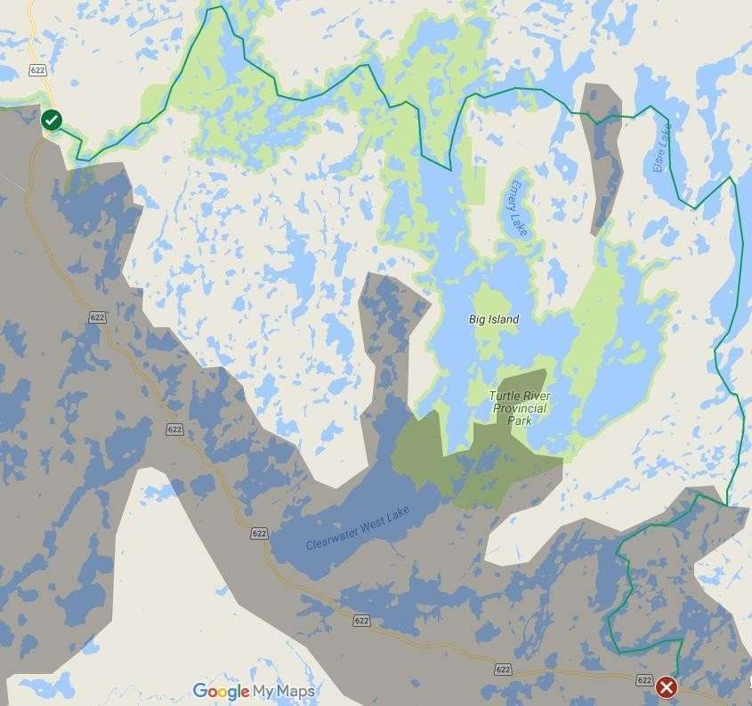
There and Back Again

Distance: 50 miles
Difficulty: Easy

     Hawknest
     White Otter
     Nora

     White Otter
     Hawknest

Maps: White Otter G/4

Keep it sweet and simple with this route. Big lakes mean your crew will be
able to cover good distance each day, once they master paddling. Expect a
couple of fun portages to make you work hard, but you’ll have a lovely camp
site to lay your head each night. Campsites along this route are known
amongst interpreters for being classy and comfortable. Plus, you’ll even get a
taste of river travel and have a chance to spot a pictograph. If your crew likes
the route but wants more of a challenge, talk to your interpreter upon arrival
about heading east through Elsie, Mabel, and Sandford, then across the Ann
Bay Portage, a 3 km portage that’ll end on a gorgeous beach on Ann Bay.

                                                                               3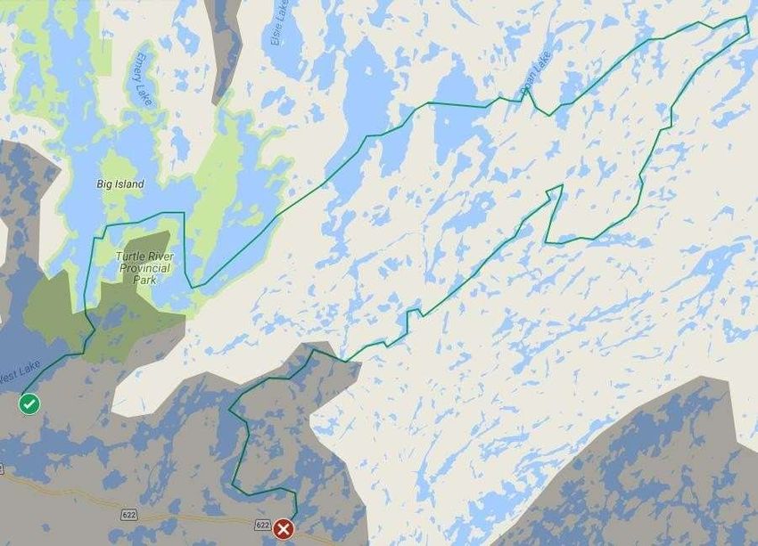
Child’s Play

      Distance: 60 miles
      Difficulty: Easy

      Route: (Clearwater
              White
              Otter Nora
              Elsie
              Mabel
              Sandford
              Wasp
              Crowrock
              Dashwa)

      Maps: White Otter G/4
            Atikokan B/13
       This route contains several large lakes that connect in a big loop. Your first and last days
require a haul to get to an area suitable for camping. This route allows your group to see White
Otter Castle and some fantastic campsites. The lakes on this route are all large to very large so
wind can play a factor in travel. Your Interpreter will have guidance in safely canoeing in this
area. This is one of the more travelled routes so you may encounter a few crews and make new
friends. Motor boats can access White Otter Lake, but they are rarely a nuisance. Consider passing
over the popular Ann Bay portage, a 3 km portage that will shorten your route to Sandford. If
more miles are of interest, consider extending into beautiful Irene and then meander down the
gamble river to continue the route from Wasp Lake.

                                                                                                  4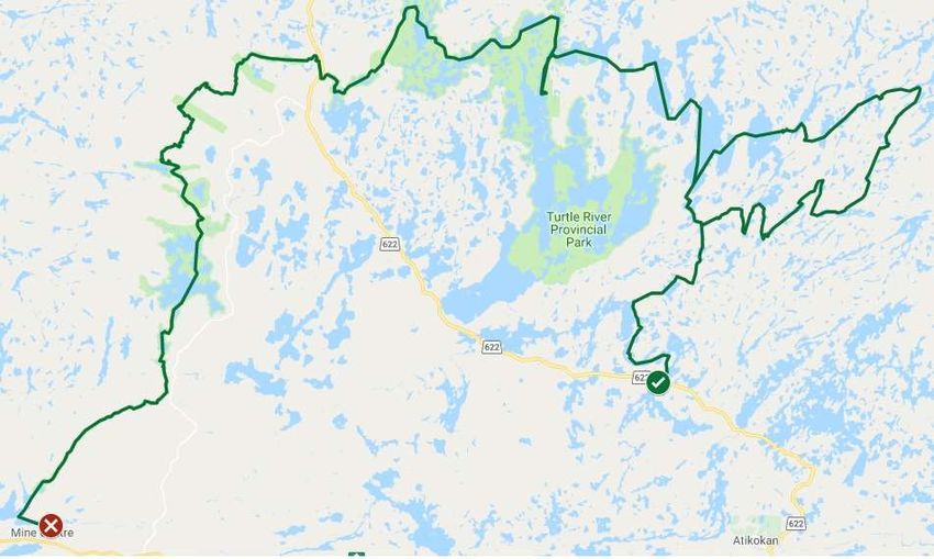
Call of the Loon

Distance: 60 miles

Difficulty: Easy/Medium

Route: (Dashwa
     Crowrock
     Wasp
     Sandford
     Mabel
     Elsie
     Nora
     White Otter
     Clearwater)

Maps: White Otter G/4
     Atikokan B/13

     This is the reverse option for Child’s Play. This route is a little bit harder,
because you’ll have a long stretch to paddle day one, when you are still
mastering paddling and portaging. Other than that, these two routes are very
similar and take you across large lakes with beautiful campsites. See White Otter
Castle. Motor boats can access these lakes, but they are rarely a nuisance.

                                                                                5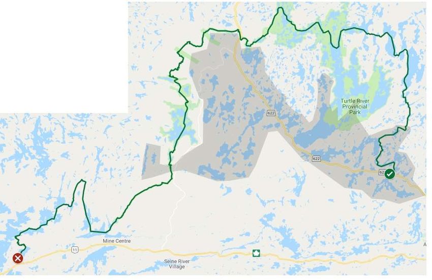
Tortoise and the Hare
Distance: 40 miles
Difficulty: Easy
Route:(Turtle River
       Smirch
       Dibble
       White Otter
       Clearwater)

Maps: White Otter G/4
     Atikokan B/13
     Pekagoning F/1

     Start your trip in a more remote area, seeking waterfalls and
pictographs along the Turtle River. Then head east to the bigger lakes. Visit
an old trapper’s cabin before stopping at the White Otter Castle. This
route has it all: great campsites, beautiful scenes, moving water and steady
lakes. It offers you glimpses of First Nation history and settlers’ past. Looking
for more miles? Add on a loop through Nora, to the north of White Otter,
ride the Turtle River south into Ann Bay and paddle back to Clearwater
for your pick up.

                                                                                6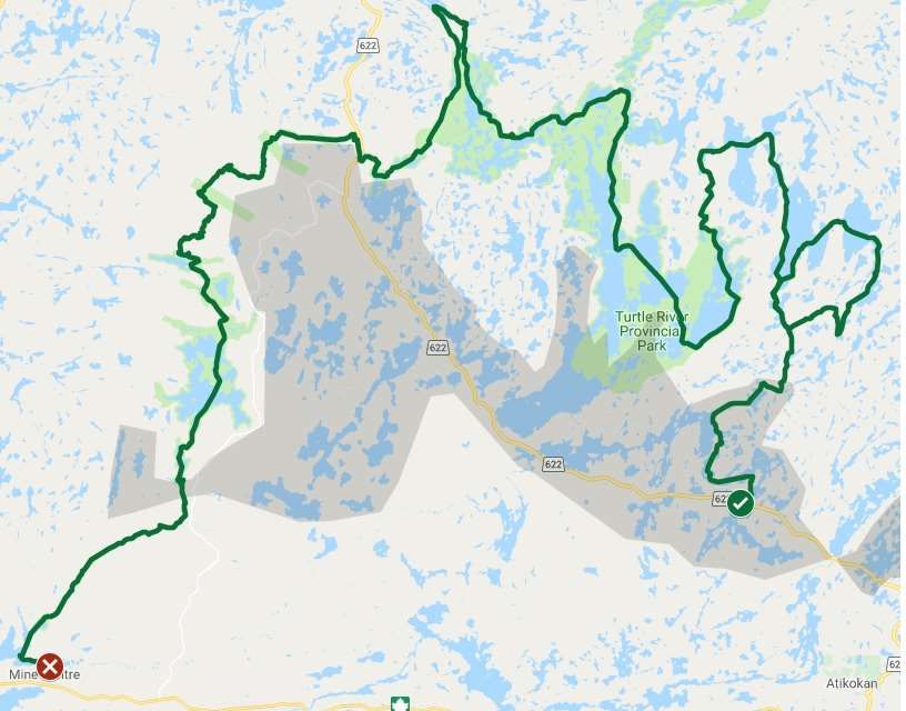
Chrysemys Picta

Difficulty: Medium
Distance: 51 miles
Route: (Turtle River
        Johnson Lake
        Turtle River
        Eltrut Lake
        Turtle River
        Robinson Lake
        Turtle River
        Little Turtle Lake)

Maps: Pekagoning F/1
      Manion C/16
      Mine Centre C/15

     This is a route for river lovers that want a mental challenge as well as a
physical. With the current behind you, paddling is a little bit speedier, but
your crew should be ready to listen to the advice of your interpreter as river
navigation means planning ahead, being on the correct side of the river
when approaching portages and being willing to get out of the canoe when
the going gets rough. Expect a few long portages and quite a few short
ones. The rewards of this route are worth any challenge. With waterfalls
and rapids moving the Turtle River through remote and beautiful woods, this
route is a treat.

                                                                             7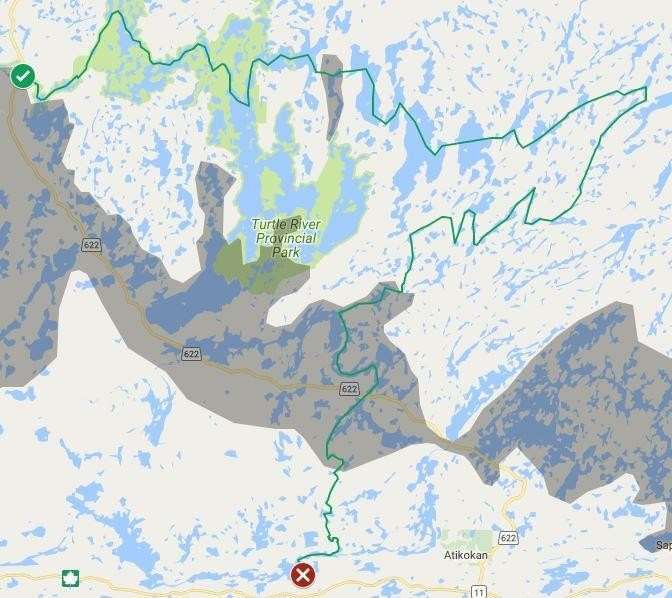
Spela Dunk

Difficulty: Medium

Distance: 50 Miles

Route:
(Clearwater,
Hawknest,
White Otter,
Heuston,
Kingfish,
Sedgwick,
Dibble,
Smirch,
Turtle River)

Maps:
White Otter G/4
Atikokan B/13,
Pekagoning F/1

     This is a new route that manages to explore a new area while also
taking time to stop by some old favorites. Begin on Clearwater Lake and
proceed northward through Hawknest into White Otter. Travel up most of
the length of this long lake before turning left and boldly going into Heuston
Lake, though not before taking a detour up to visit the famous White Otter
Castle. From Heuston, continue down to Kingfish then over to Sedgwick,
home to a small cave that makes this route famous. After a brief spelunk
and dunk, head north through a series of new and adventurous portages to
return to the beaten path of Dibble and Smirch. Paddle down the winding
Turtle River to conclude your adventure by being picked up at the
designated rendezvous spot.
                                                                          8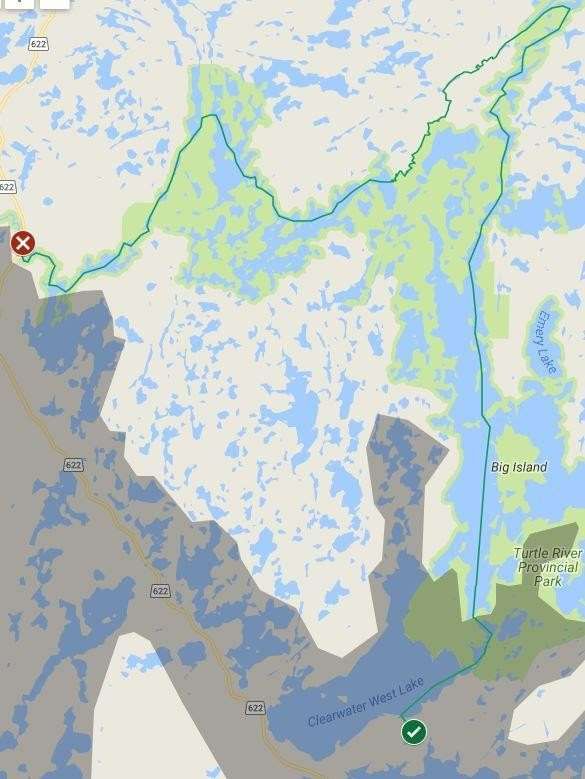
Entwash

Difficulty: Medium

Distance: 55 miles

Route: (Clearwater
     White Otter
     Sandford
     Irene
     Gamble
     River
     Little
     Gull
     Gamble
     River
     Wasp
     Dashwa)

Maps: White Otter G/4
Atikokan B/13

      From big water to rivers running, this trip gives you a sample of all that we
offer. Start on Clearwater and White Otter and head east. You’ll have
mastered paddling just in time to take on the longest portage we offer. At 3
km, Ann Bay Portage has an intimidating length, but it’s a popular trail
that’s simple to follow. Then skip across Sandford and into Irene where the
Gamble River will float you gently into Little Gull. Hop back on the river where it’s
a straightforward yet scenic paddle down Dashwa to your pick-up point.

                                                                                 9
No Sole but Duct Tape

 Difficulty: Hard
 Distance: 65 miles
 Route: (Clearwater
       White Otter
       Nora
       Elsie
       Mabel
       Sandford
       Wasp
       Below Bow
       Highland
       Hardtack
       Finlayson)

Maps: White Otter G/4
      Atikokan B/13

       Begin on quintessential Atikokan Crownland lakes and visit the White Otter Castle. Travel
across the Nora portages and visit a great island campsite or two. Then head off the beaten
path for the finale of your trip. Cross unnamed lakes in an adventurous area that has only
recently been travelled by Northern Tier crews. Cross fun portages with a variety of difficult
terrain. Then come out on Hardtack and Finlayson lakes for a beautiful end to your trip.
Consider passing over the popular Ann Bay portage, a 3 km portage that will shorten your
route to Sandford. If the 75-miler patch is of interest, consider extending into beautiful
Irene and then meander down the Gamble River to continue the route from Wasp Lake.
                                                                                               10
Leech Licks
Difficulty: Medium/Hard
Distance: 60 miles
Route: (Finlayson
Hardtack
Highland
Little Gull
Gamble River
Wasp
Dashwa
Eye
Little Eye
Eye River
Ear
Seine River
Perch
Atikokan Base)
Maps: White Otter G/4
Atikokan B/13
Begin your trip on Finlayson, a lake well loved by locals and visitors alike for its beautiful waters.
Then, head north through an area that has just recently been connected by Northern Tier staff. Expect
some tough terrain and muck on portages but know that you’ll be paddling through some gorgeous
small lakes that rarely see humans. Pass through a series of unnamed lakes and come out on Little
Gull. From there, ride the Gamble River to Wasp Lake. Then, be prepared for a long paddle south. Cross
the Green Zone of Dashwa and Eye in one day – plan to be on water for the whole day, as this is a
large distance to cover. Then, enjoy the beautiful, remote river system of the Eye River. At last,
paddle into base on your final day. Just remember, crews are not allowed to arrive in base before 1pm
as the Atikokan base staff are attending to the crews going on water in the morning. Plan to picnic
somewhere on your last day.
11Tooth and Nail
Distance: 65 miles
Difficulty:
Medium/Hard
Route: (Clearwater
White Otter
Sandford
Wasp
Crowrock
Below Bow
Highland
Hardtack
Finlayson
Little Falls
Seine River Diversion
Seine River
Perch
Atikokan
Base)
Maps: White Otter G/4
Atikokan B/13
Start with a lovely paddle across Clearwater and southern White Otter. You’ll have mastered
paddling just in time to take on the longest portage we offer. At 3 km, Ann Bay Portage has an
intimidating length, but it’s a popular trail that’s simple to follow. Relax on Sandford before
beginning your journey south. Peak at the pictographs on Wasp Lake then swing around to Below
Bow. Next, head south through an area that has rarely been traveled and shows its disuse. Paddle a
few unnamed lakes and creeks and portage over some very difficult terrain and muck. Once you hit
Finlayson, you’re nearly home free. Just follow the Seine River Diversion to the Seine River and
paddle into base.
12Distance: 50 miles
Route: (Dashwa
Crowrock
Wasp
Sandford
Irene
Little Gull
Highland
Hardtack
Finlayson)
Maps: White Otter G/4
Atikokan B/13
Start your trip with a long paddle out of the Green Zone or take on the
challenge of taking a series of portages and a beaver dammed stream.
Then keep heading north into the beautiful waters of Sandford. Next,
head east into Irene before following a portion of the Gamble River on its
lazy float into Little Gull. Be sure you’ve gotten good at paddling at
portaging during the first part of this trip because now comes the
adventurous part. Take the muddy portages south out of Little Gull to the
Bow Chain. Then, keep heading south to cross unnamed lakes in a remote
area that has only recently been travelled by Northern Tier crews. Expect
some steep hills, some mucky trail, some strange landings, and a very
rewarding wilderness adventure. Then finish your trip on Finlayson for
your pick up.
13Over or Under
Difficulty: Very Hard
Distance: 55 miles
Route: (Clearwater
White Otter
Nora
Patricia
Unnamed Lakes
Balmoral River
Dibble
Smirch
Turtle River)
Maps: White Otter G/4
Pekagoning F/1
Ignace G/5
Start off with an easy journey north through Clearwater and White Otter. Visit the White Otter Castle.
Keep heading north and begin a more difficult leg of the journey. Portage through trails that show their
disuse. If you make it through that section, it’s time for the hard part to actually start. The Balmoral
river is full of beaver dams, sand bars, and rapids, each which must be navigated through carefully.
Watch out for your ankles and mind your interpreter – they’ll have important safety advice. Expect
to build a campsite or two after long hard days on untouched shores. But if you survive the waters of
the Balmoral, it will treat you with a waterfall, pictographs, and the remote quietness of the
wilderness. Then, finish the Balmoral River and make your way through Dibble, Smirch, and a section of
the Turtle River to the pick- up. Enjoy the pictographs and waterfalls of this area as well. This route is
tough on the Kevlar canoes. For this reason, aluminum canoes are required to avoid large damage
fees.
14Distance: 40 miles
Route: (Mud Lake
Little Turtle River
Dovetail
Big Joe
Bootleg
Calm
Banning
Chub
Perch
Atikokan Base)
Maps: Manion C/12
Pipe C/9
Want to make a trip to indulge memories for decades? Then come to the remote
areas of Mud Lake and see the history of logging. Like lumber jacks, you will have to
travel hard using both land and water to cross the first 20 miles. You will be
traveling in equal measures on both and will be able to stand and proudly say you
have completed a 3-mile portage. Along the way you will see the impact and remains
of logging operations from centuries past up to a few examples of today’s impacts. You
will get to some very remote places. You will then reach the Seine River and reconnect
with civilization on the second leg of the route. Your journey ends when you reach Perch
Lake and paddle to the base’s beach landing. Like a forester you will see that in some
area nature has sought to reclaim the portages, but you and your Interpreter will be
able to cross with determination, bushwhacking, and a plan. This route will
challenge you but the sense of accomplishment you gain will empower you to great
feats. Just remember, crews are not allowed to arrive in base before 1pm, as the
Atikokan base staff are attending to the crews going on water in the morning. Plan to
picnic somewhere on your last day.
15\
Medium Trip Length Routes
(8-9 Night Trip)
(7-8 Days on Water)
16Long Way from Home
Distance: 70 miles Maps: Pekagoning F/1
Difficulty: Easy White Otter G/4
Atikokan B/13
Route: (Turtle River
Smirch
Dibble
White Otter
Nora
Elsie
Mabel
Sandford
Wasp
Crowrock
Dashwa)
This route begins on Turtle River allowing your crew to see some great rapids,
waterfalls, and pictographs. This route also includes the opportunity to see the famous
White Otter Castle. Eventually, your crew will make it to Sandford, which has some of the
clearest water in the area. The trip ends with roughly a 13-mile paddle to your pickup
point. There are portions of the route that can be changed based on your crew’s ability.
You could swing south and cross the 3 km Ann Bay Portage or add a loop east into Irene
for some river paddling and extra miles. Your Interpreter will be able to help you with any
adjustments when you arrive. This route includes some very large lakes, so wind can play
a factor in travel. Your Interpreter will have guidance in safely canoeing in this area.
17Reptilian River Raft
Distance: 85 miles
Difficulty: Medium
Route: (Turtle
River,
Johnson,
Turtle River,
Eltrut,
Turtle River,
Little Turtle,
Turtle River,
Rainy Lake (Red
Gut Bay),
Ottertail)
Maps:
Pekagoning F/1
Manion C/16
Mine Center C/15
While this route includes a lot of river travel, there are still a good number of
portages. There are a few instances of rapids around the Turtle River that will
require portages. Your Interpreter will teach you how to portage around it safely to
avoid damage to your gear, canoes, and yourselves. Be aware that if you choose this
route, you will have to paddle into Rainy Lake. Your crew will be in a relatively small
and contained bay, it is still very large, and wind may play a factor in paddling. Your
Interpreter will have guidance in safely canoeing in this area. This route will take
you through a First Nations area. Please be respectful of the community and do not
expect to camp within their bounds or use facilities. Your crew will see a large
waterfall and through one of the largest lakes in western Ontario. This route has a
lot of mileage but is an easy paddle. Your last day will take you into Ottertail to be
transported back to base.
18Tippecanoe
Difficulty: Medium
Distance: 100 mi
Route: (Clearwater
White
Otter Nora
Patricia
Dimple
Dibble
Smirch
Turtle River
Maps: White Otter G/4
Jones
Pekagoning F/1 Eltrut
Manion C/16 Robinson
Mine Centre C/15 Turtle
River Little
Turtle)
Begin on the big lakes of Clearwater and White Otter. Visit the White Otter Castle, then head
north. Take the challenging portages into Patricia and float the Jac Saga River through tall grass.
Paddle across Dibble and Smirch. Keep your eyes out for pictographs near a waterfall and a rapid.
Then begin your journey south into a more remote area. Follow the Turtle River south and portage
around waterfalls and rapids in this beautiful, remote area. Finish the trip on Little Turtle Lake near
Mine Centre. Be prepared to carry your gear to the pick-up point, as our vans cannot drive directly to
the water. There are motor boats on White Otter and Little Turtle Lake, but they are usually friendly
and polite, just looking to enjoy the water and the fish. This trip is great for seeing major sights of
the area as well as some waterfalls and rapids.
19Albatross
Distance: 75 miles
Difficulty: Medium
Route:
(Clearwater,
White Otter,
Nora,
Elsie,
Mabel,
Sandford,
Irene,
Gamble River,
Little Gull,
Wasp,
Sandford,
Ann Bay,
White Otter,
Clearwater)
Maps:
White Otter B/4
This is a fantastic route that takes you through the sights and the
sites to see in our area of the Crownlands. Visit White Otter Castle. Head
East through the lady lakes of Nora, Elsie, Mabel and Irene. These lakes
are beautiful paddling experiences, giving you plenty of time on water.
Head south then west by riding the Gamble River through a section of lazy
stream then into a well-paced river. Visit Sandford Lake, a favorite of
Interpreters for its clean water and fantastic island campsites. Take on
the challenge of the 3 km Ann Bay Portage, our longest portage. It
certainly takes a long time to walk, but with the right attitude, definitely
accomplishable. Then finish your trip via Clearwater.
20The Shuttle Driver
Difficulty: Medium/Hard
Distance: 77 Miles
Route: (Atikokan Base
Perch
Seine River
Eye River
Eye
Dashwa
Wasp
Sandford
Irene
Gamble River
Little Gull
Highland
Hardtack
Finlayson
Seine River Diversion
Little Falls
Seine River
Perch
Atikokan Base)
Maps: White Otter G/4,
Atikokan B/13
Indulge in this historic new route, one that is a complete loop which begins and ends at the
beautiful beach landing of the Atikokan Base. No shuttle driver needed. Begin by paddling up the Eye
River, portaging past a waterfall as you go, then prepare for a 23-mile paddle through the Green
Zone. This can be a long, challenging, yet rewarding day of travel that many crews have successfully
completed. From there, head north into the crystal blue waters of Sandford and proceed east into
Irene before starting south again. Meander down the Gamble River into Little Gull, then press ever
onward into Highland Creek. Cross unnamed lakes in this adventurous area that has only recently been
travelled by Northern Tier crews. Emerge from the challenge triumphantly onto Finlayson. Once on
Finlayson, all that is left is to paddle your way down the Seine River back to base, exactly where your
adventure began. Just remember, crews are not allowed to arrive in base before 1pm, as the
Atikokan base staff are attending to the crews going on water in the morning. Plan to picnic
somewhere on your last day.
21Fish Sticks
Distance: 85 miles
Difficulty: Medium/Hard
Route: (Dashwa,
Below Bow,
Lower Bow,
Upper Bow,
Sparkle,
Adele,
Boulder,
Gamble,
Doan,
Irene,
Sandford,
Wasp,
Dashwa)
Maps: Atikokan B/13
White Otter G/4 Gulliver G/3
Begin your adventure with a long paddle out of Dashwa, then head up the Bow Chain.
Though it’ll take some effort, this beginning will get you into more remote areas right away. The
Bow Chain is known for good fishing and for good moose sightings – so stay quiet and keep your
eyes out. Then head north through a series of unnamed lakes before visiting Sparkle and Adele.
Next up, pass through two famous and dynamic portages, one of which has earned the name “Fun
and Games,” but both will make sure you remember them. Then begin heading back toward your
pick-up. Either route through the Gamble River or through Sandford Lake. Upon returning to
Dashwa, you may choose a long paddle or a series of portages and beaver dams.
22Jiimaan
Route: (Clearwater
White
Otter
Sandfor
d Irene
Doan
Gamble
Distance: 80 miles Boulder
Adele
Difficulty: Medium/Hard Sparkle
Upper Bow
Maps: Atikokan B/12 Lower Bow
White Otter G/4 Below Bow
Gulliver G/3 Dashwa)
Start on the big lakes of Clearwater, White Otter, and Sandford and
take the time to master paddling. Portage practice will come by crossing
the Ann Bay Portage, a popular 3 km long portage. Once you’ve passed
through this educational area, it is time to trek into a more remote area.
Cross two challenging 1 km trails – one of which has earned the name “Fun
and Games”. Enjoy solitude and adventure as you traverse remote and wild
lakes that have yet to be named. Finally, your crew’s grand finale will be a
gentle paddle through the Green Zone, giving you a chance to reflect on the
teamwork and skills gained as you paddle to your pick-up point.
23All the Fun and Games
Route: (Dashwa,
Below Bow,
Lower Bow,
Little Gull,
Sparkle,
Adele,
Gamble,
Doan,
Distance: 95 miles Irene,
Sandford,
Difficulty: Medium/Hard Ann Bay Portage,
Maps: Atikokan B/12 White Otter,
Nora,
White Otter G/4 White Otter,
Clearwater)
Gulliver G/3
Your crew will start the route by traveling through Dashwa to Below Bow. This
area is great for spotting wildlife. Once through the Bow lakes, you enter the wild
country and create a big loop through the “Lady Lakes”. This is a fantastic and remote
area. Eventually, you will get to cross the Ann Bay Portage, a popular 3 km long
portage. Then you get to set your canoes in White Otter Lake, paddle up to Nora, then
back down to White Otter to visit its famous Castle. Finally, your crew enters
Clearwater to be picked up and transported back to base. Motor boats can access White
Otter Lake, but they generally are just out for some good fishing too and are rarely a
nuisance. This route includes some very large lakes so wind can play a factor in travel.
Your Interpreter will have guidance in safely canoeing in this area.
24Turtle Toes
Difficulty: Hard
Distance: 95 miles
Route: (Finlayson,
Hardtack,
Highland,
Lower Bow,
Upper Bow,
Sparkle,
Adele,
Boulder,
Gamble,
Grummet Creek,
Upper Doan,
Doan,
Irene,
Sandford,
Wasp,
Dashwa,
Eye
Little Eye,
Eye River,
Ear,
Seine River,
Perch,
Atikokan Base)
Maps: Atikokan B/12
White Otter
G/4 Gulliver G/3
Start your journey with a bit of a challenge. From Finlayson, go through a less
traveled area from Hardtack to Highland to Lower Bow. This area has some tough portages
with steep ups and mucky downs, but also offers some beautiful sights. Take Lower Bow
and Upper Bow north to a remote section of lakes. Begin journeying west and check out an
area that no Northern Tier crew has visited in recent years, but where there once were
trails connecting Gamble, Grummet Creek, and Upper Doan (or cut south to take “Fun &
Games”). Coast through the big lakes of Irene and Sandford before heading south through
the Green Zone. Plan for a long day’s paddling as you’ll need to cross Dashwa and Eye
before you can camp. Then, follow the Eye River chain, a stunning area, to the Seine River.
At long last, paddle yourself into base! Just remember, crews are not allowed to arrive in
base before 1pm as the Atikokan base staff are attending to the crews going on water in
the morning. Plan to picnic somewhere on your last day.
25Yo-Yo
Difficulty: Hard/ Very Hard
Distance: 88 miles
Route: (Clearwater
Hawknest
White Otter
Nora
Patricia
Balmoral
McNamara
Agimak
McNamara
Balmoral
Patricia
Nora
White Otter
Hawknest
Clearwater)
Maps: Atikokan B/12
White Otter G/4
Ignace G/5
This is the only trip that consists of a 100% Yo-Yo route. Why would one
choose to do this? It is still a challenging route as getting up to the town of
Ignace will require some crafty navigation and determined and creative
portaging, but the reward is an afternoon in town where you can treat
yourself to a hot meal and cold ice cream. The second reason is that your
return will provide a fantastic oppurtunity to put your newfound skills to the
test and witness just how much you’ve grown individually and as a canoe
travelling team. If you’re looking for a greater test of your skills, consider
travelling down the Balmoral River upon on your return. This river is a
remote, challenging, team building machine that can also provide relief
from the mental strain a true yo-yo route can provide. Note: The Balmoral
River requires aluminum caoes to avoid the potential for damaged gear.
26Neapolitan Ice Cream
Difficulty: Very Hard
Distance: 75 miles
Route: (Finlayson
Hardtack
Serpent
Upper
Bow
Sparkle
Adele
Boulder
Gamble
Doan Maps: Atikokan B/12
Irene White Otter G/4
Sandford Gulliver G/3
White Otter
Clearwater)
Hungry for more? This route takes you across our three most famous portages: Red
Paint, Fun & Games, and Ann Bay. Red Paint is a 2 km muck slog that can take anywhere
from an hour and a half to four hours. Fun & Games involves some creative over-and-unders
with your canoes and packs. Ann Bay hits a full 3 km, making it our longest portage. If
these portages were the worst this route had to offer, then it wouldn’t earn its difficulty
rating. Before even making it to Red Paint, cross muddy, difficult terrain on fresh cut
portages. Hack your way into Serpent through dense woods and across marshland. Only
then will you hit Red Paint. After Red Paint, head north through remote unnamed lakes.
Cross a kilometer-long portage that offers its own trials and tribulations before hitting “Fun
& Games” for more work. Only then will you take hike on Ann Bay Portage. At long last,
you’ll paddle your way into Clearwater for your pick-up.
27Long Trip Length Routes
(10-11 Night Trip)
(9-10 Days on Water)
28Follow the Sunset
Route: (Dashwa
Crowrock
Wasp
Sandford
Mabel
Elsie
Nora
Distance: 120 miles White Otter
Dibble
Difficulty: Medium Kenoshay
Turtle River
Maps: White Otter G/4 Jones
Eltrut
Pekagoning F/1 Robinson
Manion C/16 Turtle River
Mine Centre C/15 Little Turtle)
This route can really give you a taste of all we offer here. Start your trip paddling
across big lakes, stay at an island campsite, enjoy the wide waters. Then visit the White
Otter Castle and even swing past an old trapper’s cabin. Head west on Dibble and visit a
pictograph. Then cut through Kenoshay to do some bushwhacking and really test your
meddle in what might be an easy addition, or could be a hard fight through thick brush.
Then ride the Turtle River south all the way to Mine Centre. Enjoy the waterfalls, rapids,
and the portages around them as well as the easy current that will give you a little bit of
a boost. Portage to your pick-up at Mine Centre.
29Yellow Brick Road
Distance: 125 miles
Difficulty: Medium
Route:
(Turtle River,
Smirch,
Dibble,
White Otter,
Nora
Elsie,
Mabel,
Sandford,
Irene,
Doan,
Gamble,
Adele,
Sparkle,
Upper Bow,
Lower Bow,
Little Gull,
Gamble River,
Wasp,
Dashwa, Maps: White Otter G/4
Eye, Pekagoning F/1
Eye River,
Gulliver G/3
Ear,
Seine River, Atikokan B/1
Perch,
Atikokan Base)
This route starts with the shuttle sweeping you away to our farthest drop off point. Then
you’ll have to follow this route all the way home. Beginning on the Turtle River, you’ll see a few
waterfalls and rapids. Keep your eyes peeled for pictographs. Then head east. You can visit an old
trapper’s cabin and the White Otter Castle. Follow big lakes further east and be amazed with how
your canoe can speed across the water on smooth days (or, if you’re less lucky, how much wind
can slow down even the strongest paddle strokes). Even further east you will go, into a more
remote area. Expect to cross two 1 km portages, one of which earned the name “Fun and Games.”
At long last you can begin your journey south. Take the follow Upper Bow and Lower Bow to a
couple mucky portages, then float down the Gamble River. Spend a long day’s work passing
through the Green Zone to the Eye River. Follow this river chain through a beautiful area to the
Seine River. Float your way back to base. Crews are not allowed to arrive in base before 1pm as
the Atikokan base staff are attending to the crews going on water in the morning. Plan to picnic
somewhere on your last day.
30Distance: 200 miles Route:
(Dashwa,
Difficulty: Medium/Hard Below Bow,
Lower Bow,
Maps: Upper Bow,
Atikokan B/12 Sparkle,
Gulliver G/3 Adele,
White Otter G/4 Gamble,
Stormy F/8 Doan,
Irene,
Pekagoning F/1
Gamble River,
Manion C/16 Little Gull,
Mine Centre C/15 Sanford,
Mabel,
Hungry for the 200-miler award? Then this Nora,
route will make you earn it, tooth and nail. White Otter,
Paddle the remote waters east of the big Smirch,
lakes and conquer a series of unnamed lakes Bending,
and a few very hard portages. Take the Turtle River,
central lake system through some stunning Jones,
big water and visit the White Otter Castle Eltrut,
and a trapper’s cabin. Spot pictographs, Robinson,
waterfalls, and rapids as your crew makes Turtle River,
its way west and south. This route will give Little Turtle Lake,
you days where you see no other person but Otter Lake,
your own crew mates, and days you can Turtle River,
wave to people in motor boats as they go Redgut Bay of Rainy Lake,
by. You’ll be able to check off nearly every
Ottertail)
part of the Atikokan experience.
31Hoot and a Half
Route: Dimple, Begin your trip with a long paddle out of the Green
(Dashwa, Dibble, Zone. Keep heading north to get a glimpse of
Wasp, Smirch,
Sandford before starting your journey east. Cross
Sandford, Bending,
Irene, Turtle River, over the tricky “Fun and Games” portage. Meet
Doan, Johnson, Adele and Sparkle before heading south into a
Gamble, Eltrut, serious of unnamed lakes. Take the Bow Chain west
Boulder, Robinson, and ride the Gamble River back into Wasp. Face
Adele, Turtle River, Sandford again, from south to north, before moving
Sparkle, Little Turtle)
Upper Bow, into Mabel, Elsie, and White Otter. See the White
Lower Bow, Otter Castle and the remains of a POW camp. Head
Little Gull, north through Nora into Patricia. Then begin follow
Gamble River, the sun west down a creek into Dibble. Now you’re
Wasp, on the Turtle River, and you’ll remain in its waters
Sanford,
for the rest of your trip. Go north into Bending Lake
Mabel,
Elsie, then turn south. See rapids, waterfalls, and even a
Turtle River, pictograph. Pass through Johnson, Eltrut, and
White Otter, Robinson Lake before tackling the last stretch of the
Nora, river into Little Turtle Lake for your pick up.
Patricia,
32Pike on a Bite
Distance: 105 miles
Difficulty: Hard
Route:
(Clearwater,
White Otter,
Nora,
Elsie,
Mabel,
Sandford,
Wasp,
Lower Bow,
Upper Bow,
Red Paint,
Serpent,
Hardtack,
Finlayson,
Seine River Diversion,
Little Falls,
Seine River Diversion,
Seine River,
Perch,
Atikokan Base)
Maps: White Otter G/4
Atikokan B/12
Gulliver G/3
If you want to see everything on the map, you’ll want to select this route. This
route includes some very large lakes so wind can play a factor in travel. Your
Interpreter will have guidance in safely canoeing in this area. Beginning on Clearwater,
you’ll travel through White Otter and then the Lady Lakes. Eventually, you’ll end up at
the Red Paint Portage which is just over 1-mile of muddy trail and takes a few hours
for even the strongest. It’s difficult, but finishing is truly a treat! After, you’ll go down
Serpent, and, depending on the year, break trail into Hardtack, and then Finlayson
until you get to the Seine River Diversion. While it is a river, be prepared to portage
around the rapids as you make your way down the slow current. Eventually, this all
leads to Perch Lake where you can have the unique opportunity to paddle into base.
Crews are not allowed to arrive in base before 1pm as the Atikokan base staff are
attending to the crews going on water in the morning. Plan to picnic somewhere on
your last day.
33Bon Voyage
Difficulty: Hard
Length: 150 Miles
Route:
(Dashwa,
Crowrock,
Wasp,
Sandford,
Mabel,
Elsie,
Nora,
White Otter,
Dibble,
Smirch,
Turtle River,
Jones,
Eltrut, Maps: White Otter G/4 Atikokan B/13
Robinson,
Turtle River, Pekagoning F/1 Manion C/16
Little Turtle, Mine Centre C/15
Otter,
Turtle River,
Redgut Bay of Rainy Lake,
Ottertail)
This route travels through a mix of large, popular lakes and rolling rivers which will
give your crew a taste of almost all the Atikokan Crown Lands have to offer. Begin on
Dashwa and work your way north out of the Green Zone. Continue North through the
crystal blue waters of Sandford then West through Elsie and Mabel. Enjoy a few dynamic
portages and explore the rich history of the area along the way. White Otter Castle can be
a pit stop before moving onto the Turtle River, which you follow for about 90 miles. This
route will have long days in order to earn all 150 miles. Expect interesting portages,
waterfalls, excellent fishing, and a chance to truly hone your wilderness travel skills.
Additionally, this route will take your crew through a First Nations area. Please be
respectful of the community and do not expect to camp within their bounds or use
facilities. Your last day will take you into Ottertail to be transported back to base.
34Maps: White Otter G/4
Difficulty:
Atikokan B/13
Hard/Very Hard
Crownlandapalooza Pekagoning F/1
Manion C/16
Distance: 175 miles
Mine Centre C/15
Route:
(Dashwa,
Crowrock,
Wasp,
Sandford,
Irene,
Little Gull,
Gamble River,
Wasp,
Sandford,
Mable,
Campus,
Elsie,
Halfmoon,
Ann Bay,
White Otter,
Nora,
Patricia,
Dimple, Are you ready to travel everywhere? Take this grand tour of the
Dibble, Crown Lands and travel from the East to the West, seeing lakes and
Smirch, rivers on this adventure. You start out with a long paddle or series
of portages out of the green zone and get to head to the East into
Turtle River,
Wasp and Irene. Then come back on the Gamble River as you ready
Jones, yourself for different environment. Travel westward to the beauty
Turtle River, of Ann Bay and her pictographs and onto the main area of White
Eltrut, Otter to see the White Otter Castle stand tall. Further on your trail
Turtle River, you will see more rivers and water falls and make your way into the
Turtle River with its rewarding fishing. After clearing that area, you
Little Turtle)
will exit out on to Mine Centre. You will have to portage up to the
van as they cannot make it to the water front.
35Difficulty: Very Hard Distance: 105 miles
No Mountain
Unsummited Maps: Atikokan B/12 White Otter G/4
Ignace G/5 Gulliver G/3 Pekagoning F/1
Route:
(Finlayson
Hardtack
Serpent
Red Paint
Upper Bow
Sparkle
Adele
Boulder
Gamble
Doan
Irene
Sandford
Mabel
Elsie
Nora
Patricia
Balmoral
Balmoral River
Dibble
Smirch
Turtle River)
Are you seeking the ability to challenge yourself and summit some of
the most arduous and beautiful areas Atikokan has to offer? If so, then
prepare yourselves to travel on portages made by Northern Tier in some
deeply remote areas of the Crown Lands. Your crew will face four
challenging areas: the work of Highland Creek, the mud of Red Paint
Portage, navigating “Fun and Games”, and the wilderness of the Balmoral
River. The climb will be difficult, but the memories will last a life time. This
route is tough on the Kevlar canoes. For this reason, aluminum canoes are
required to avoid large damage fees.
36Distance:
115 miles
Difficulty:
Very Hard
Route:
(Clearwater,
White Otter,
Nora,
Patricia,
Balmoral,
Balmoral River,
Dibble,
Smirch,
Turtle River,
Johnson,
Eltrut,
Robinson,
Maps: White Otter G/4, Ignace G/5, Stormy F/8, Turtle River,
Pekagoning F/1, Manion C/16, Mine Centre C/15 Little Turtle)
When your crew puts in at Clearwater, North is the way to go. Up Clearwater, up
White Otter, past White Otter Castle, up Nora, up Patricia, up and over a series of hard,
soggy portages where few people roam, up to Balmoral. Then turn east and take on the
challenge that makes this route Very Hard: the Balmoral River. Go over, go under, get out
of the canoe, get back in, and most importantly, careful of your ankles. The Balmoral
River takes only the best on its waters, but if you make it, you’ll have the pleasure of
remote wilderness, a waterfall very few ever see, and the chance to grow together
through teamwork. Cross Dibble then head north again. Keep out an eye for
pictographs and paddle carefully – there’s whitewater to portage around. Take your
crew north to Smirch before beginning the southern branch of the Turtle River. Follow
the gentle current down a stunning river. Take a variety of short and long portages
around rapids and waterfalls. Finish your trip on Little Turtle Lake near Mine Centre.
37The Log Flume
Difficulty: Very hard
Distance: 111 miles
Route:
(Atikokan Base,
Perch,
Seine River,
Eye River,
Eye,
Dashwa,
Wasp,
Sandford,
Mable,
Elsie,
Halfmoon,
Nora,
White Otter,
Hawknest,
Clearwater, The history of this route is many fold. Be among the few who
Turtle, have been able to paddle out of Atikokan Base and return to it on
Mud Lake, the same trip. While you’re doing this, you will see the large White
Little Turtle Otter Castle; the work of a woodsmen and prospector. Further
River, along your route in Mud Lake you will see modern and traditional
Dovetail, logging patches and be able to learn about their history. This route
Big Joe, contains some rather challenging areas at the end of your trip, but
you will have time to train. Still, be warned this route will be
Bootleg, challenging to your body and soul, so be ready for anything on this
Calm, adventure. There will be a day that is equal parts paddling and
Banning, portaging. So, are you ready to embrace the culture of the north
Chub, woods and ride the Log Flume? Just remember, crews are not
Perch, allowed to arrive in base before 1pm as the Atikokan base staff are
attending to the crews going on water in the morning. Plan to
Atikokan Base)
picnic somewhere on your last day.
38Difficulty:
Hard
Interpreter Down
Distance:
190 miles
Route:
(Seine River,
Eye River,
Ear,
Eye,
Dashwa,
Sparkle,
Adele,
Gamble,
Doan,
Irene,
Gamble
River,
Little Gull,
Wasp,
Sandford,
Mabel,
Elsie,
Turtle River,
White Otter,
Nora,
Patricia,
Smirch, Start your journey headed south on the Seine River Diversion. Hop
Bending, around a few rapids and a dam before joining in the main Seine River.
Turtle River) Enjoy paddling with the current while you can, because next you’ll
head north up the Eye River. Enjoy some peace and quiet passing
Maps: through Ear Lake and Little Eye before embarking on a long paddle
Atikokan through the Green Zone with Eye and Dashwa. Follow the Bow Chain
B/13 northeast. Meet some remote unnamed lakes and pass into Sparkle and
White Otter Adele Turtle River before turning west. Tackle the Fun and Games
G/4 portage - known for being a tricky trail. Then take Irene to the Gamble
Gulliver River and relax on a nice float. Now it’s time to test your paddling
G/3 skills on large lakes from Sandford, to Mabel, to Elsie, to White Otter.
Pekagoning See the White Otter Castle and the remains of a POW camp. Take a
F/1 detour into Clearwater for a few extra miles. Head north through some
strange portages and then follow a creek between Dimple and Dibble
Lake. Then follow the Turtle River north into Smirch and Bending, then
south again toward your pick up. Be sure to enjoy the beautiful
waterfalls, rapids, and even a pictograph.
39Float Plane
Routes
40White Otter (Ann Bay) to Dashwa via
Sandford
Distance: 56 miles
Difficulty: Easy/Medium
Route:
(White Otter, Nora, Halfmoon,
Elsie, Mabel, Sandford, Wasp,
Crowrock, Dashwa)
Maps:
White Otter G/4
Atikokan B/13
This route has the float plane set you
down in Ann Bay, setting you up to
paddle to whole of White Otter Lake.
By the time your crew visits the White
Otter Castle, you’ll be pro paddlers,
which is good because you have more
large water to paddle through. Take on
Nora’s mucky portages and head east
into Elsie and Mabel. Enjoy your time
paddling the entirety of Sandford. It’s a
lake known for its beautiful waters and
great campsites. See the Wasp Lake
pictographs before settling in for your
final night. On your last day, cross the
Green Zone either by paddling
Crowrock and Dashwa lakes, or cut
through a series of portages and beaver
dams. Your shuttle will meet you on
Dashwa’s sandy landing with a beautiful
41Dibble to
Dashwa
via
dock.
Distance: 54 miles
Difficulty: Easy/Medium
Route:
(Smirch, Dibble,
White Otter, Nora,
Elsie, Mabel,
Sandford, Wasp,
Crowrock, Dashwa)
Maps:
Pekagoning F/1
White Otter G/4
Atikokan B/13
Begin your trip in Smirch Lake and start heading south. Take time to enjoy the
waterfall as you portage into Dibble. From Dibble begin your eastward journey.
See an old trapper’s cabin just before you enter White Otter Lake. Visit White
Otter Castle before portaging into Nora. It’s time to master big lake paddling as
you cross from Nora into Elsie, Mabel and Sandford. Master portaging through muck
and rocks. On Sandford, enjoy the vistas this large lake offers and visit an island
campsite or beachy shore. Spend your last night on Wasp lake. On your last day,
cross the Green Zone either by paddling Crowrock and Dashwa lakes, or cut
through a series of portages and beaver dams. Your shuttle will meet you on
Dashwa’s sandy landing with a beautiful dock.
42You can also read