Rwanda Étude de bureau - Rome, 2020
←
→
Page content transcription
If your browser does not render page correctly, please read the page content below
Étude de bureau

   Rwanda

    Rome, 2020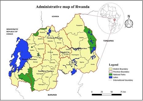
FRA 2020 Étude de bureau, Rwanda

Depuis 1946, la FAO assure un suivi des ressources forestières mondiales tous les 5 à 10 ans. Les évaluations des ressources forestières mondiales (FRA) sont désormais produites tous les cinq ans afin de fournir une
approche cohérente pour décrire les forêts du monde et leur évolution. FRA est un processus piloté par les pays et les évaluations reposent sur les rapports préparés par les correspondants nationaux nommés
officiellement. Si aucun rapport n'est disponible, le secrétariat de FRA prépare une étude de bureau à l'aide de rapports antérieurs, d'informations existantes et/ou d'analyses basées sur des études par télédétection.

Ce document a été généré automatiquement à partir d'une étude de bureau. La FAO ne peut être tenu responsable de l'utilisation qui pourrait être faite des informations contenues dans le présent rapport.

                                                                                                               2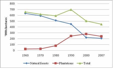
FRA 2020 Étude de bureau, Rwanda

                                                                    TABLE DES MATIÈRES

        Introduction

        1. Étendue, caractéristiques et changement des forêts

        2. Matériel sur pied, biomasse et carbone forestiers

        3. Désignation et gestion des forêts

        4. Droits de propriété et de gestion des forêts

        5. Perturbations forestières

        6. Politiques et dispositions législatives sur les forêts

        7. Emploi, enseignement et PFNL

        8. Objectif de développement durable 15

                                                                               3
FRA 2020 Étude de bureau, Rwanda
Introduction
Texte d'introduction
No official report was received. This report was the subject of a desk study by the FRA Secretariat summarizing the existing information in the format indicated for the FRA 2020 national reports.
Rwanda
The Republic of Rwanda lies in east-central Africa. The terrain consist of a north–south ridge of the watershed between the Zaire and Nile rivers, with elevations of 2 400–3 000 m; highlands, which decrease in elevation from west to east; and a
large area of hills and swampy lakes in the east with elevations of 1 400–1 700 m. There is also a group of volcanoes in the far northwest.
The climate is equatorial montane, with an average annual temperature of 20 °C and relatively moderate rainfall spread throughout the year. Average annual rainfall is less than 1 000 mm in the east and 1 250–2 400 mm in the west. In the FAO
global map of ecological zones Rwanda belongs just to the tropical mountain zone.
Main tree species are Eucalyptus spp., Strombosia scheffleri and Pinus patula. Main forest types are the broadleaved mountain dense natural forests, open broadleaved sclerophyllous forests and the broadleaved eastern natural forest formations.
[1] Also some savannah woodlands and gallery forests exist. The dominant planted species are Eucalyptus spp. with Pinus spp..
Concerning plantations and reforestation, the forest law in force set in motion a tree-planting regime to complement the reforestation effort. This is a legal instrument designed to develop forest plantations on agricultural land for the dual purpose
of soil protection and wood production. [2]Rwanda’s Nationally Determined Contributions promote, in the program of action for Sustainable Forestry, Agroforestry and Biomass Energy, afforestation/reforestation of designated areas through
enhanced germplasm and technical practices in planting and post-planting processes along with employ Improved Forest Management for degraded forest resources. It is also state in the vision for mitigation avoiding deforestation along with
other important issues.[3]
Figure: Adminsitrative map of Rwanda [4]
[1] Rwanda - Global Forest Resources Assessment 2015 – Country Report, FAO, 2015. Retrieved April 27, 2017.
[2] Country Profiles – Department of Forest http://www.fao.org/forestry/country/en/ . FAO. Retrieved April 27, 2017.
[3] UNFCCC Nationally Determined Contribution (NDC) Rwanda. October 06, 2016. Retrieved April 27, 2017.
[4] FOREST INVESTMENT PROGRAM FOR RWANDA. Ministry of Lands and Forestry. Republic of Rwanda. Prepared by: Rwanda Water and Forestry Authority, Led MDB: African Development Bank Group, Supporting MDB: The World Bank. 10
November 2017.
https://www.climateinvestmentfunds.org/sites/cif_enc/files/fip_final_rwanda.pdf
4FRA 2020 Étude de bureau, Rwanda
1 Étendue, caractéristiques et changement des forêts
1a Étendue des forêts et des autres terres boisées
Données nationales
Source des données + type de source de données par ex. IFN, etc
References Variables Year
Natural forest
FOREST INVESTMENT PROGRAM FOR RWANDA. Ministry of Lands and Forestry. Republic of Rwanda. Prepared by: Rwanda Water and Forestry Authority, Led area and
1 2008
MDB: African Development Bank Group, Supporting MDB: The World Bank. 10 November 2017. https://www.climateinvestmentfunds.org/sites/cif_enc/files/fip_final_rwanda.pdf change,
Plantation area
FOREST PLANTATIONS AND WOODLOTS IN RWANDA. AFRICAN FOREST FORUM WORKING PAPER SERIES. Volume 1. Issue 14, 2011.
2 Plantation area 2010
https://www.researchgate.net/publication/301695197_Forest_Plantations_and_Woodlots_in_Rwanda
RWANDA FOREST COVER MAPPING USING HIGH RESOLUTION AERIAL PHOTOGRAPHS (Paper presented at the Global Geospatial Conference 2013 integrating Africa GIS2013 and GSDI 14 which was held from 4th to 8th
3 November 2013 at Addis Ababa, Ethiopia). Nduwamungu Jean, Nyandwi Elias, Mazimpaka Jean Damascene, Mugiraneza Theodomir, Mukashema Adrie, Uwayezu Ernest, Rwanyiziri Gaspard and Nzabanita Vital.
https://www.researchgate.net/publication/301695298_RWANDA_FOREST_COVER_MAPPING_USING_HIGH_RESOLUTION_AERIAL_PHOTOGRAPHS_1
BIOMASS ENERGY STRATEGY (BEST), RWANDA. Volume 2 - Background & Analysis. Reference NO.: 81098569. Project NO: 01.2457.8-007.24. June 2009. EUEI PDF- GTZ- MARGE. 1990,
4 Plantation area
https://www.cleancookingalliance.org/binary-data/RESOURCE/file/000/000/35-1.pdf 2000
Classification et définitions nationales
Definition of Forest in Rwanda (from reference 1, page 6)
Forest: The 2012 forest cover mapping of Rwanda from Orthophotos, defined forests based on ability to map them as: A group of trees higher than 7 m and a canopy cover of more than 10 %, or trees able to reach these thresholds in situ on a
land area of 0.25 ha or more (CGIS and RNRA, 2012).
Shrublands: were defined as: A group of perennial trees smaller than 7 m (shrubs) at maturity and a canopy cover of more than 10% on a land area of 0.25 ha or more (CGIS and RNRA, 2012). However, the R-PP, referring to the conditions in
which forests of Rwanda exist, defined forests as A group of trees and bamboo plantations, higher than 2m and a canopy cover of more than 10 %, or trees and bamboos plantations able to reach these thresholds in situ on a land of at least 0.05
ha (MINIRENA/RNRA, 2014).
State forest: A forest found on state land planted by the State, Government Project, planted through community work or any other organ, a natural forest, forest planted along State roadsides, along the shores of rivers and lakes, a forest
transferred to the State and any other unowned forest (Forest Law 2013).
District forest: A forest located on a District land and that was planted by the District, a District project, planted through community work or planted by any other organ partnering with the District, a forest along the District roads or forest that has
been transferred to the District (forest Law 2013).
Public forests: Refers to all State forests and District forests (Forest Law 2013)
Private forests: Are forests planted by an individual, planted through community work or by any other person on private land. Private forest could be small scattered forests that include agroforestry systems or large contiguous blocks of trees.
Trees inside forests (TIF): Are specifically trees in forest plantations on public lands.
Trees on other lands (ToFo): Are classified as trees either in agroforestry systems or on shrublands.
Données de base
Text copied from reference 3, pages 3 and 4:
"The high resolution aerial photographs (to a resolution of 25 cm) used were acquired from the former National Land Center (now the Department of Lands and Mapping under the RNRA).
A few high resolution satellite images (4%) were also used to complete the aerial photo coverage along the border lines between Rwanda and the Democratic Republic of Congo (DRC) and over the Volcanoes National Park area for security and
meteorological conditions reasons. The majority of aerial photographs used in this project were taken in 2008 and a few in 2009 during an aerial survey mission carried out by Swedesurvey and were supplied in the form of orthophotographs.
Orthophotographs (or orthophotos) are digital aerial photographs from which distortions owing to camera tilt and ground relief have been removed. An orthophoto has the same scale throughout and can be used as a map. The extraction of forest
5FRA 2020 Étude de bureau, Rwanda
polygons was performed using the acquired orthophotos of 2008. Consequently, all forest plantations that could not be identified from the 2008 images (that is probably all forest plantations established from 2007 onwards) are not included in the
GIS database produced in this project. However, the database can be updated using GIS tools once new images or survey data are available.
In order to harmonize the concept of a forest and facilitate the process of forest polygon extraction, a “forest” was defined as follows: “a group of trees higher than 7 m and a canopy 4 cover of more than 10 %, or trees able to reach these
thresholds in situ on a land of about 0.25 ha or more”. However, since in the eastern parts of the country there is a woody vegetation commonly called “shrub” which could not fit in the above definition of forest and another definition was adopted
for what was considered as shrub: “a group of perennial trees smaller than 7 m (shrubs) at maturity and a canopy cover of more than 10% on a land of about 0.25 ha or more”.
The visual interpretation algorithms for image interpretation were used to ease forest polygons extraction and further related characterisation delineation. The proposed scheme for the classification of vegetation and forest types followed a
stepwise approach based on forest categories, forest types and forest canopies (degree of canopy closure). After fieldwork and confirmation on the ground of the forest resources found in Rwanda, the forest classes were finally adopted to be
included in the attributes of digitized forest polygons."
The majority of the aerial photos used are from 2008, which is used as reference year for the data.
[1]
Table 2: Forest cover per province (from reference 1, page 7)
Province Natural forest (ha) Forest plantation (ha) Shrubland (ha) Total (ha)
Northern 11,716 54,813 - 66,529
Southern 42,850 109,765 582 153,197
Eastern 1,843 35,986 258,403 296,232
Western 69,733 74,905 1,519 146,157
Kigali City 59 11,340 - 11,399
Total 126,201 286,809 260,504 673,516
[1] Taken from Rwanda National Forest Inventory - 2015
Table 6: Change over time (1984 to 2015) of key natural forests in Rwanda
(from reference 1, page 12 )
Name of the forest Area (ha) 1984 Area (ha) 2015 % Loss
Buhanda Natural Forest 1116 18 98.4%
Gishwati Natural Forest 21213 1440 93.2%
Mashyuza Natural Forest 85 6 92.7%
Ibanda-Makera Natural Forest 1425 169 88.1%
Karama Natural Forest 3235 1061 67.2%
Dutake Natural Forest 31 11 65.7%
Karehe-Gatuntu Natural Forest Complex 48 19 60.3%
Nyagasenyi Natural Forest 45 19 58.2%
Akagera National Park 267,741 112,185 58.1%
Mukura Natural Forest 4376 1988 54.6%
Sanza Natural Forest 49 24 51.0%
Mashoza Natural Forest 36 18 51.0%
6FRA 2020 Étude de bureau, Rwanda
Muvumba Natural Forest 1286 688 46.5%
Ndoha Natural Forest 39 29 26.0%
Kibirizi-Muyira Natural Forest 454 352 22.4%
Busaga Natural Forest 191 159 16.9%
Nyungwe National Park 112,230 101,005 10.0%
Volcanoes National Park 16,128 16,004 0.8%
Total 429,728.47 235,192.27 45.27%
Note that the natural forest area in this data set comprises both forest and shrublands. The figure on forest loss has been used to estimate the forest area before 2008.
Text and table copied from reference 2, page 11 and 17:
"The alarming degradation of forest cover and encroachment of natural forests observed during the 1970s due to population pressure, led to the creation by decree of the Rwanda Office of Tourism and National Parks (ORTPN) in 1974 (FAO, 2002).
This office was charged to ensure the protection of all national parks and to manage tourist activities in parks. The development of tourism today and effective protection of the remaining natural vegetation in the country can be mainly attributed to
the efforts made by ORTPN since its establishment in 1974. In fact, currently almost all the remaining natural forests are under protected area management."
Table 5: Overall forest areas in 2010. Sources: MINIRENA/CGIS-NUR (2007), FAO (2010), RDB (2010), PAFOR and PAREF reports (2011).
Area (ha)
Forest classes
(rounded to nearest 100 ha)
Protected areas 224 000
Akagera National Park 108 500
Nyungwe National Park 97 000
Volcano National Park 16 000
Gishwati Forest Reserve 1 000
Mukura Forest Reserve 1 600
Plantations 301 500
Eucalypts plantations 63 600
Young plantations and coppice (mainly Eucalyptus spp. and Acacia spp.) * 62 700
Softwood plantation (Pinus spp., Cupressus spp. And Callitris spp.) 12 100
Woodlots and tree resources outside forests (Eucalyptus spp., Grevillea spp., Pinus spp., Cupressus spp.; Callitris spp., Acacia spp., Alnus spp., Casuarina spp.) 162 800
Total 525 500
Note: MINIRENA/CGIS-NUR (2007) plus young plantations by PAFOR (16 764 ha) and PAREF (6 747 ha).
Figure 3: Evolution of Forest Areas in Rwanda (> 0.5 ha) (from reference 4, page 20)
7FRA 2020 Étude de bureau, Rwanda
Sources: MINAGRI for 1960 to 2000, ISAR for 2007
Analyse et traitement des données nationales
Estimation et prévision
(a) It is assumed zero natural forest loss in the period 2008-2015, based on the statement in reference 2, page 11: "In fact, currently almost all the remaining natural forests are under protected area management."
(b) As stated in reference 3, the majority of aerial photographs used in the project were taken in 2008, therefore the data is considered to be from 2008 (and not 2015 when the results of the forest inventory were published).
(c) Furthermore, it is also assumed that the area of Scrublands of 2008 corresponds to Other Wooded Land and it is maintained constant for the whole time series.
(d) and finally, the areas of plantation for 1990 and 2000 are estimated at 245 000 and 275 000 respectively according to reference 4, figure 3. However these figures also includes small woodlots and some areas with trees outside forest and have
therefore been adjusted (see below).
Estimations for natural forests are as follows:
Natural Forest in 2008 was: 126,135 (from reference 2 Table 3)
Forest loss between 1984-2008 : 45.27% (from reference 2 Table 6)
Natural forest 1984 (estimated using loss rate above) 230,468
Estimated natural forest loss 1984-2008 (ha) 104,333
Estimated annual natural forest loss 1984-2008 (ha/yr) 4347
Estimates for plantations
From reference 2, page 17
Plantations in 2010 Area (ha) % of the total plantation area
Eucalyptus plantations 63600
Young plantations and coppice 62700
Softwood plantation 12100
Small woodlots and ToF 162800 54%
8FRA 2020 Étude de bureau, Rwanda
Total plantations including small woodlots and ToF 301200
Forest plantations excluding small woodlots and ToF) 138400 46%
The above assumptions and estimates gives the following estimated time series:
Areas in 1000 ha: 2008 1990 2000 2010 2015 2016 2017 2018 2019 2020
Naturally regenerating forest 126 204 161 126 126 126 126 126 126 126
Plantations incl. woodloots and ToF 287 245 275
Plantations excl. woodlots and ToF (46% of above) 113 127 138 144 146 147 148 149 150
Other Wooded Land 261 261 261 261 261 261 261 261 261 261
TOTAL FOREST 317 287 265 270 272 273 274 275 276
Reclassification dans les catégories de FRA 2020
-
9FRA 2020 Étude de bureau, Rwanda
1000 ha Forêt Autre terre boisée
300
250
200
150
100
50
0
1990 1995 2000 2005 2010 2015 2020
10FRA 2020 Étude de bureau, Rwanda
Superficie (1000 ha)
Catégories de FRA
1990 2000 2010 2015 2016 2017 2018 2019 2020
Forêt (a) 317.00 287.00 265.00 270.00 272.00 273.00 274.00 275.00 276.00
Autre terre boisée (a) 261.00 261.00 261.00 261.00 261.00 261.00 261.00 261.00 261.00
Autre terre (c-a-b) 1 889.00 1 919.00 1 941.00 1 936.00 1 934.00 1 933.00 1 932.00 1 931.00 1 930.00
Total des terres émergées
2 467.00 2 467.00 2 467.00 2 467.00 2 467.00 2 467.00 2 467.00 2 467.00 2 467.00
(c)
La superficie des terres
enregistrée par FAOSTAT pour
l'année 2015 est utilisée pour
toutes les années de référence
Domaine climatique % de superficie forestière 2015 Remplacer valeur
Boréal 0.00
Tempéré 0.00
Sous-tropical 0.00
Tropical 100.00
Commentaires
11FRA 2020 Étude de bureau, Rwanda
1b Caractéristiques des forêts
Données nationales
Source des données + type de source de données par ex. IFN, etc
References Variables Year
FOREST INVESTMENT PROGRAM FOR RWANDA. Ministry of Lands and Forestry. Republic of Rwanda. Prepared by: Rwanda Water and Forestry Authority, Led Natural forest area and change,
1 2008
MDB: African Development Bank Group, Supporting MDB: The World Bank. 10 November 2017. https://www.climateinvestmentfunds.org/sites/cif_enc/files/fip_final_rwanda.pdf Plantation area
FOREST PLANTATIONS AND WOODLOTS IN RWANDA. AFRICAN FOREST FORUM WORKING PAPER SERIES. Volume 1. Issue 14, 2011.
2 Plantation area 2010
https://www.researchgate.net/publication/301695197_Forest_Plantations_and_Woodlots_in_Rwanda
RWANDA FOREST COVER MAPPING USING HIGH RESOLUTION AERIAL PHOTOGRAPHS (Paper presented at the Global Geospatial Conference 2013 integrating Africa
GIS2013 and GSDI 14 which was held from 4th to 8th November 2013 at Addis Ababa, Ethiopia). Nduwamungu Jean, Nyandwi Elias, Mazimpaka Jean Damascene, Mugiraneza
3
Theodomir, Mukashema Adrie, Uwayezu Ernest, Rwanyiziri Gaspard and Nzabanita Vital.
https://www.researchgate.net/publication/301695298_RWANDA_FOREST_COVER_MAPPING_USING_HIGH_RESOLUTION_AERIAL_PHOTOGRAPHS_1
BIOMASS ENERGY STRATEGY (BEST), RWANDA. Volume 2 - Background & Analysis. Reference NO.: 81098569. Project NO: 01.2457.8-007.24. June 2009.
4 EUEI PDF- GTZ- MARGE. Plantation area 1990, 2000
https://www.cleancookingalliance.org/binary-data/RESOURCE/file/000/000/35-1.pdf
Classification et définitions nationales
Definition of Forest in Rwanda (from reference 1, page 6)
Forest: The 2012 forest cover mapping of Rwanda from Orthophotos, defined forests based on ability to map them as A group of trees higher than 7 m and a canopy cover of more than 10 %, or trees able to reach these thresholds in situ on a
land area of 0.25 ha or more (CGIS and RNRA, 2012).
Shrublands: were defined as A group of perennial trees smaller than 7 m (shrubs) at maturity and a canopy cover of more than 10% on a land area of 0.25 ha or more (CGIS and RNRA, 2012). However, the R-PP, referring to the conditions in which
forests of Rwanda exist, defined forests as A group of trees and bamboo plantations, higher than 2m and a canopy cover of more than 10 %, or trees and bamboos plantations able to reach these thresholds in situ on a land of at least 0.05 ha
(MINIRENA/RNRA, 2014).
State forest: A forest found on state land planted by the State, Government Project, planted through community work or any other organ, a natural forest, forest planted along State roadsides, along the shores of rivers and lakes, a forest
transferred to the State and any other unowned forest (Forest Law 2013).
District forest: A forest located on a District land and that was planted by the District, a District project, planted through community work or planted by any other organ partnering with the District, a forest along the District roads or forest that has
been transferred to the District (forest Law 2013).
Public forests: Refers to all State forests and District forests (Forest Law 2013)
Private forests: Are forests planted by an individual, planted through community work or by any other person on private land. Private forest could be small scattered forests that include agroforestry systems or large contiguous blocks of trees.
Trees inside forests (TIF): Are specifically trees in forest plantations on public lands.
Trees on other lands (ToFo): Are classified as trees either in agroforestry systems or on shrub lands.
Données de base
Text copied from reference 3, pages 3 and 4:
"The high resolution aerial photographs (to a resolution of 25 cm) used were acquired from the former National Land Center (now the Department of Lands and Mapping under the RNRA).
A few high resolution satellite images (4%) were also used to complete the aerial photo coverage along the border lines between Rwanda and the Democratic Republic of Congo (DRC) and over the Volcanoes National Park area for security and
meteorological conditions reasons. The majority of aerial photographs used in this project were taken in 2008 and a few in 2009 during an aerial survey mission carried out by Swedesurvey and were supplied in the form of orthophotographs.
Orthophotographs (or orthophotos) are digital aerial photographs from which distortions owing to camera tilt and ground relief have been removed. An orthophoto has the same scale throughout and can be used as a map. The extraction of forest
polygons was performed using the acquired orthophotos of 2008. Consequently, all forest plantations that could not be identified from the 2008 images (that is probably all forest plantations established from 2007 onwards) are not included in the
GIS database produced in this project. However, the database can be updated using GIS tools once new images or survey data are available.
12FRA 2020 Étude de bureau, Rwanda
In order to harmonize the concept of a forest and facilitate the process of forest polygon extraction, a “forest” was defined as follows: “a group of trees higher than 7 m and a canopy 4 cover of more than 10 %, or trees able to reach these
thresholds in situ on a land of about 0.25 ha or more”. However, since in the eastern parts of the country there is a woody vegetation commonly called “shrub” which could not fit in the above definition of forest and another definition was adopted
for what was considered as shrub: “a group of perennial trees smaller than 7 m (shrubs) at maturity and a canopy cover of more than 10% on a land of about 0.25 ha or more”.
The visual interpretation algorithms for image interpretation were used to ease forest polygons extraction and further related characterisation delineation. The proposed scheme for the classification of vegetation and forest types followed a
stepwise approach based on forest categories, forest types and forest canopies (degree of canopy closure). After fieldwork and confirmation on the ground of the forest resources found in Rwanda, the forest classes were finally adopted to be
included in the attributes of digitized forest polygons."
[1]
Table 2: Forest cover per province (from reference 1, page 7)
Province Natural forest (ha) Forest plantation (ha) Shrubland (ha) Total (ha)
Northern 11,716 54,813 - 66,529
Southern 42,850 109,765 582 153,197
Eastern 1,843 35,986 258,403 296,232
Western 69,733 74,905 1,519 146,157
Kigali City 59 11,340 - 11,399
Total 126,201 286,809 260,504 673,516
[1] Taken from Rwanda National Forest Inventory - 2015
Table 6: Change over time (1984 to 2015) of key natural forests in Rwanda
(from reference 1, page 12)
Name of the forest Area (ha) 1984 Area (ha) 2015 % Loss
Buhanda Natural Forest 1116 18 98.4%
Gishwati Natural Forest 21213 1440 93.2%
Mashyuza Natural Forest 85 6 92.7%
Ibanda-Makera Natural Forest 1425 169 88.1%
Karama Natural Forest 3235 1061 67.2%
Dutake Natural Forest 31 11 65.7%
Karehe-Gatuntu Natural Forest Complex 48 19 60.3%
Nyagasenyi Natural Forest 45 19 58.2%
Akagera National Park 267,741 112,185 58.1%
Mukura Natural Forest 4376 1988 54.6%
Sanza Natural Forest 49 24 51.0%
Mashoza Natural Forest 36 18 51.0%
Muvumba Natural Forest 1286 688 46.5%
Ndoha Natural Forest 39 29 26.0%
Kibirizi-Muyira Natural Forest 454 352 22.4%
13FRA 2020 Étude de bureau, Rwanda
Busaga Natural Forest 191 159 16.9%
Nyungwe National Park 112,230 101,005 10.0%
Volcanoes National Park 16,128 16,004 0.8%
Total 429,728.47 235,192.27 45.27%
Text and table copied from reference 2, page 11 and 17:
"The alarming degradation of forest cover and encroachment of natural forests observed during the 1970s due to population pressure, led to the creation by decree of the Rwanda Office of Tourism and National Parks (ORTPN) in 1974 (FAO, 2002).
This office was charged to ensure the protection of all national parks and to manage tourist activities in parks. The development of tourism today and effective protection of the remaining natural vegetation in the country can be mainly attributed to
the efforts made by ORTPN since its establishment in 1974. In fact, currently almost all the remaining natural forests are under protected area management."
Table 5: Overall forest areas in 2010. Sources: MINIRENA/CGIS-NUR (2007), FAO (2010), RDB (2010), PAFOR and PAREF reports (2011).
Area (ha)
Forest classes
(rounded to nearest 100 ha)
Protected areas 224 000
Akagera National Park 108 500
Nyungwe National Park 97 000
Volcano National Park 16 000
Gishwati Forest Reserve 1 000
Mukura Forest Reserve 1 600
Plantations 301 500
Eucalypts plantations 63 600
Young plantations and coppice (mainly Eucalyptus spp. and Acacia spp.) * 62 700
Softwood plantation (Pinus spp., Cupressus spp. And Callitris spp.) 12 100
Woodlots and tree resources outside forests (Eucalyptus spp., Grevillea spp., Pinus spp., Cupressus spp.; Callitris spp., Acacia spp., Alnus spp., Casuarina spp.) 162 800
Total 525 500
Note: MINIRENA/CGIS-NUR (2007) plus young plantations by PAFOR (16 764 ha) and PAREF (6 747 ha).
Figure 3: Evolution of Forest Areas in Rwanda (> 0.5 ha) (from reference 4, page 20)
14FRA 2020 Étude de bureau, Rwanda
Sources: MINAGRI for 1960 to 2000, ISAR for 2007
Analyse et traitement des données nationales
Estimation et prévision
(a) It is assumed zero natural forest loss in the period 2008-2015, based on the statement in reference 2, page 11: "In fact, currently almost all the remaining natural forests are under protected area management."
(b) As stated in reference 3, the majority of aerial photographs used in the project were taken in 2008, therefore the data is considered to be from 2008 (and not 2015 when the results of the forest inventory were published).
(c) Furthermore, it is also assumed that the area of Scrublands of 2008 corresponds to Other Wooded Land and it is maintained constant for the whole time series.
(d) and finally, the areas of plantation for 1990 and 2000 are estimated at 245 000 and 275 000 respectively according to reference 4, figure 3. However these figures also includes small woodlots and some areas with trees outside forest and have
therefore been adjusted (see below).
Then:
Natural Forest in 2008 was: 126,135 (from reference 2 Table 3)
Forest loss between 1984-2015 (2008): 45.27% (from reference 2 Table 6)
Natural forest 1984 (estimated) 230,468
Estimated natural forest loss 1984-2008 (ha) 104,333
Estimated annual natural forest loss 1984-2008 (ha) 4347
From reference 2, page 17
Plantations in 2010 Area (ha) % of the total area
Eucalyptus plantations 63600
Young plantations and coppice 62700
Softwood plantation 12100
Small woodlots and ToF 162800 54%
Total 301200
15FRA 2020 Étude de bureau, Rwanda
Forest plantations (total - Small woodlots and ToF) 138400 46%
From reference 4, figure 3:
The areas of plantation for 1990 and 2000 are estimated at 245 000 and 275 000 respectively.
Reclassification dans les catégories de FRA 2020
Areas in 1000 ha: 2008 1990 2000 2010 2015 2016 2017 2018 2019 2020
Naturally regenerating forest 126 204 161 126 126 126 126 126 126 126
Plantations incl. woodloots and ToF 287 245 275
Plantations excl. woodlots and ToF (46% of above) 113 127 138 144 146 147 148 149 150
Other Wooded Land 261 261 261 261 261 261 261 261 261 261
TOTAL FOREST 317 287 265 270 272 273 274 275 276
16FRA 2020 Étude de bureau, Rwanda
1000 ha Forêt naturellement régénérée Forêt de plantation Autre forêt plantée
200
150
100
50
0
1990 1995 2000 2005 2010 2015 2020
17FRA 2020 Étude de bureau, Rwanda
Superficie forestière (1000 ha)
Catégories de FRA
1990 2000 2010 2015 2016 2017 2018 2019 2020
Forêt naturellement régénérée
204.00 161.00 126.00 126.00 126.00 126.00 126.00 126.00 126.00
(a)
Forêt plantée (b) 113.00 126.50 138.01 144.00 146.00 147.00 148.00 149.00 150.00
Forêt de plantation 113.00 126.50 138.01 144.00 146.00 147.00 148.00 149.00 150.00
…dont d'espèces introduites
Autre forêt plantée 0.00 0.00 0.00 0.00 0.00 0.00 0.00 0.00 0.00
Total (a+b) 317.00 287.50 264.01 270.00 272.00 273.00 274.00 275.00 276.00
Total superficie forestière 317.00 287.00 265.00 270.00 272.00 273.00 274.00 275.00 276.00
Commentaires
18FRA 2020 Étude de bureau, Rwanda
1c Forêt primaire et catégories spéciales de forêts
Données nationales
Source des données + type de source de données par ex. IFN, etc
-
Classification et définitions nationales
-
Données de base
-
Analyse et traitement des données nationales
Estimation et prévision
-
Reclassification dans les catégories de FRA 2020
-
19FRA 2020 Étude de bureau, Rwanda
Superficie (1000 ha)
Catégories de FRA
1990 2000 2010 2015 2020
Forêt primaire
Temporairement non boisée
et/ou récemment régénérée
Bambous
Mangroves 0.00 0.00 0.00 0.00 0.00
Bois de caoutchouc
Commentaires
As a landlocked country, it is assumed that area of mangroves is zero.
20FRA 2020 Étude de bureau, Rwanda
1d Expansion annuelle de la forêt, déforestation et changement net
Données nationales
Source des données + type de source de données par ex. IFN, etc
-
Classification et définitions nationales
-
Données de base
-
Analyse et traitement des données nationales
Estimation et prévision
-
Reclassification dans les catégories de FRA 2020
-
21FRA 2020 Étude de bureau, Rwanda
Superficie (1000 ha/an)
Catégories de FRA
1990-2000 2000-2010 2010-2015 2015-2020
Expansion de la forêt (a)
…dont boisement
…dont expansion naturelle
Déforestation (b)
Changement net de la
-3.00 -2.20 1.00 1.20
superficie forestière (a-b)
Commentaires
22FRA 2020 Étude de bureau, Rwanda
1e Reboisement annuel
Données nationales
Source des données + type de source de données par ex. IFN, etc
-
Classification et définitions nationales
-
Données de base
-
Analyse et traitement des données nationales
Estimation et prévision
-
Reclassification dans les catégories de FRA 2020
-
23FRA 2020 Étude de bureau, Rwanda
Superficie (1000 ha/an)
Catégories de FRA
1990-2000 2000-2010 2010-2015 2015-2020
Reboisement 1.38 1.19 1.19 1.19
Commentaires
Data derived from the assumptions and estimations done in table 1b.
24FRA 2020 Étude de bureau, Rwanda
1f Autre terre dotée de couvert arboré
Données nationales
Source des données + type de source de données par ex. IFN, etc
-
Classification et définitions nationales
-
Données de base
-
Analyse et traitement des données nationales
Estimation et prévision
-
Reclassification dans les catégories de FRA 2020
-
25FRA 2020 Étude de bureau, Rwanda
Superficie (1000 ha)
Catégories de FRA
1990 2000 2010 2015 2020
Palmiers (a)
Vergers (b)
Système agroforestier (c)
Arbres en milieu urbain (d)
Autre (préciser dans les
commentaires) (e)
Total (a+b+c+d+e) − − − − −
Superficie d'autre terre 1 889.00 1 919.00 1 941.00 1 936.00 1 930.00
Commentaires
26FRA 2020 Étude de bureau, Rwanda
2 Matériel sur pied, biomasse et carbone forestiers
2a Matériel sur pied
Données nationales
Source des données + type de source de données par ex. IFN, etc
1. Rapport de la Commission Nationale d’Agriculture, 1991.
2. 2007 ISAR Forest Inventory, cited in Biomass Energy Strategy (BEST), Rwanda Volume 2 - Background & Analysis.
Classification et définitions nationales
-
Données de base
Data from source 1: Natural Forest
ha m3/ha
Nyungwe +Cyamudongo 60900 130
Mukura + Gishwati 2100 60
Galeries + Savanes arborées 55000 40
Weighted average volume 86.8
Data from source 2, table 3: Plantations:
Average volume of plantations: 122.6 m3/ha
Analyse et traitement des données nationales
Estimation et prévision
The same growing stock per hectare has been used for all reporting years
Reclassification dans les catégories de FRA 2020
-
27FRA 2020 Étude de bureau, Rwanda
Matériel sur pied m³/ha (sur écorce)
Catégories de FRA
1990 2000 2010 2015 2016 2017 2018 2019 2020
Forêt naturellement régénérée 86.80 86.80 86.80 86.80 86.80 86.80 86.80 86.80 86.80
Forêt plantée 122.60 122.60 122.60 122.60 122.60 122.60 122.60 122.60 122.60
…dont forêt de plantation 122.60 122.60 122.60 122.60 122.60 122.60 122.60 122.60 122.60
…dont autre forêt plantée
Forêt 99.56 102.72 105.13 105.89 106.03 106.08 106.13 106.22 106.27
Autre terre boisée
Total matériel sur pied (millions m³ sur écorce)
Catégories de FRA
1990 2000 2010 2015 2016 2017 2018 2019 2020
Forêt naturellement régénérée 17.71 13.97 10.94 10.94 10.94 10.94 10.94 10.94 10.94
Forêt plantée 13.85 15.51 16.92 17.65 17.90 18.02 18.14 18.27 18.39
…dont forêt de plantation 13.85 15.51 16.92 17.65 17.90 18.02 18.14 18.27 18.39
…dont autre forêt plantée 0.00 0.00 0.00 0.00 0.00 0.00 0.00 0.00 0.00
Forêt 31.56 29.48 27.86 28.59 28.84 28.96 29.08 29.21 29.33
Autre terre boisée
Commentaires
28FRA 2020 Étude de bureau, Rwanda
2b Composition du matériel sur pied
Données nationales
Source des données + type de source de données par ex. IFN, etc
-
Classification et définitions nationales
-
Données de base
-
Analyse et traitement des données nationales
Estimation et prévision
-
Reclassification dans les catégories de FRA 2020
-
29FRA 2020 Étude de bureau, Rwanda
Matériel sur pied dans la forêt (millions m³ sur écorce)
Catégories de FRA Dénomination scientifique Dénomination usuelle
1990 2000 2010 2015 2020
Espèce d'arbre indigène
#1 Classé(e) en volume
#2 Classé(e) en volume
#3 Classé(e) en volume
#4 Classé(e) en volume
#5 Classé(e) en volume
#6 Classé(e) en volume
#7 Classé(e) en volume
#8 Classé(e) en volume
#9 Classé(e) en volume
#10 Classé(e) en volume
Espèces d'arbres indigènes restantes
Volume total espèces d'arbres indigènes − − − − −
Espèce d'arbre introduite
#1 Classé(e) en volume
#2 Classé(e) en volume
#3 Classé(e) en volume
#4 Classé(e) en volume
#5 Classé(e) en volume
Espèces d'arbres introduites restantes
Volume total espèces d'arbres introduites − − − − −
Total matériel sur pied − − − − −
Commentaires
30FRA 2020 Étude de bureau, Rwanda
2c Biomasse
Données nationales
Source des données + type de source de données par ex. IFN, etc
-
Classification et définitions nationales
-
Données de base
Data from tables 1b and 2a were used as input to the biomass calculator spreadsheet.
Analyse et traitement des données nationales
Estimation et prévision
Insert the percentages of Growing stock by IPCC forest type for each of the FRA forest categories
FRA forest categories
IPCC forest types Naturally regenerating forest Plantation forest Other planted forest
% of Growing stock
Broadleaved humid 75% 50%
Broadleaved dry 25% 50%
Coniferous 0% 0%
100% 100% 0% Must add up to 100%
Insert Carbon fraction used by country (IPCC default = 0.47)
Carbon Fraction 47%
Biomass conversion and expansion factors (BCEF)
Naturally regenerating forest 1990 2000 2010 2015 2016 2017 2018 2019 2020
Broadleaved humid 1.50 1.50 1.50 1.50 1.50 1.50 1.50 1.50 1.50
Broadleaved dry 1.50 1.50 1.50 1.50 1.50 1.50 1.50 1.50 1.50
Coniferous 0.76 0.76 0.76 0.76 0.76 0.76 0.76 0.76 0.76
31FRA 2020 Étude de bureau, Rwanda
Plantation forest
Broadleaved humid 1.30 1.30 1.30 1.30 1.30 1.30 1.30 1.30 1.30
Broadleaved dry 1.30 1.30 1.30 1.30 1.30 1.30 1.30 1.30 1.30
Coniferous 0.70 0.70 0.70 0.70 0.70 0.70 0.70 0.70 0.70
Other planted forest
Broadleaved humid
Broadleaved dry
Coniferous
Weighted BCEF
Naturally regenerating forest 1.50 1.50 1.50 1.50 1.50 1.50 1.50 1.50 1.50
Plantation forest 1.30 1.30 1.30 1.30 1.30 1.30 1.30 1.30 1.30
Other planted forest
Root-shoot ratios
Naturally regenerating forest 1990 2000 2010 2015 2016 2017 2018 2019 2020
Broadleaved humid 0.24 0.24 0.24 0.24 0.24 0.24 0.24 0.24 0.24
Broadleaved dry 0.28 0.28 0.28 0.28 0.28 0.28 0.28 0.28 0.28
Coniferous 0.29 0.29 0.29 0.29 0.29 0.29 0.29 0.29 0.29
Plantation forest
Broadleaved humid 0.24 0.24 0.24 0.24 0.24 0.24 0.24 0.24 0.24
Broadleaved dry 0.28 0.28 0.28 0.28 0.28 0.28 0.28 0.28 0.28
Coniferous 0.20 0.20 0.20 0.20 0.20 0.20 0.20 0.20 0.20
Other planted forest
Broadleaved humid
Broadleaved dry
Coniferous
Weighted RS ratio
Naturally regenerating forest 0.25 0.25 0.25 0.25 0.25 0.25 0.25 0.25 0.25
Plantation forest 0.26 0.26 0.26 0.26 0.26 0.26 0.26 0.26 0.26
Other planted forest
32FRA 2020 Étude de bureau, Rwanda
Above-ground biomass (t/ha)
1990 2000 2010 2015 2016 2017 2018 2019 2020
Naturally regenerating forest 130.20 130.20 130.20 130.20 130.20 130.20 130.20 130.20 130.20
Plantation forest 159.38 159.38 159.38 159.38 159.38 159.38 159.38 159.38 159.38
Other planted forest
Total 140.60 143.04 145.45 145.76 145.86 145.91 145.96 146.01 146.06
Below-ground biomass (t/ha)
1990 2000 2010 2015 2016 2017 2018 2019 2020
Naturally regenerating forest 32.55 32.55 32.55 32.55 32.55 32.55 32.55 32.55 32.55
Plantation forest 41.44 41.44 41.44 41.44 41.44 41.44 41.44 41.44 41.44
Other planted forest
Total 35.72 36.46 37.20 37.29 37.32 37.34 37.35 37.37 37.38
Reclassification dans les catégories de FRA 2020
-
33FRA 2020 Étude de bureau, Rwanda
Biomasse forestière (tonnes/ha)
Catégories de FRA
1990 2000 2010 2015 2016 2017 2018 2019 2020
Biomasse aérienne 140.60 143.04 145.45 145.76 145.86 145.91 145.96 146.01 146.06
Biomasse souterraine 35.72 36.46 37.20 37.29 37.32 37.34 37.35 37.37 37.38
Bois mort
Commentaires
34FRA 2020 Étude de bureau, Rwanda
2d Carbone
Données nationales
Source des données + type de source de données par ex. IFN, etc
-
Classification et définitions nationales
-
Données de base
Data from tables 1b and 2a were used as input to the biomass calculator spreadsheet.
Analyse et traitement des données nationales
Estimation et prévision
See table 2c.
Reclassification dans les catégories de FRA 2020
-
35FRA 2020 Étude de bureau, Rwanda
Carbone forestier (tonnes/ha)
Catégories de FRA
1990 2000 2010 2015 2016 2017 2018 2019 2020
Carbone dans la biomasse
66.08 67.23 68.36 68.51 68.56 68.58 68.60 68.62 68.65
aérienne
Carbone dans la biomasse
16.79 17.14 17.48 17.53 17.54 17.55 17.56 17.56 17.57
souterraine
Carbone dans le bois mort
Carbone dans la litière 2.10 2.10 2.10 2.10 2.10 2.10 2.10 2.10 2.10
Carbone dans le sol 47.00 47.00 47.00 47.00 47.00 47.00 47.00 47.00 47.00
Profondeur du sol (cm)
utilisée pour les estimations 30.00
du carbone dans le sol
Commentaires
Data on litter and soil carbon from the IPCC 2006 guidelines.
36FRA 2020 Étude de bureau, Rwanda
3 Désignation et gestion des forêts
3a Objectif de gestion désigné
Données nationales
Source des données + type de source de données par ex. IFN, etc
-
Classification et définitions nationales
-
Données de base
-
Analyse et traitement des données nationales
Estimation et prévision
-
Reclassification dans les catégories de FRA 2020
-
37FRA 2020 Étude de bureau, Rwanda
Objectif de gestion désigné principal
Superficie forestière (1000 ha)
Catégories de FRA 2020
1990 2000 2010 2015 2020
Production (a)
Protection du sol et de l'eau
(b)
Conservation de la
biodiversité (c)
Services sociaux (d)
Usages multiples (e)
Autre (à préciser dans les
commentaires) (f)
Aucune fonction/Fonction
317.00 287.00 265.00 270.00 276.00
inconnue (g)
Superficie forestière totale 317.00 287.00 265.00 270.00 276.00
Superficie totale avec un objectif de gestion désigné
Superficie forestière (1000 ha)
Catégories de FRA 2020
1990 2000 2010 2015 2020
Production
Protection du sol et de l'eau
Conservation de la
biodiversité
Services sociaux
Autre (à préciser dans les
commentaires)
Commentaires
38FRA 2020 Étude de bureau, Rwanda
3b Superficie forestière se trouvant à l'intérieur d'aires protégées juridiquement constituées et superficie forestière soumise à des
plans de gestion forestière à long-terme
Données nationales
Source des données + type de source de données par ex. IFN, etc
The data comes from the tools offered by this platform - WCMC protected areas and Hansen's tree cover map.
Classification et définitions nationales
-
Données de base
Categories 2000 2001 2002 2003 2004 2005 2006 2007 2008 2009 2010 2011 2012 2013 2014 2015 2016 2017
Total area of protected areas (ha) 224,556 224,556 224,556 224,556 224,556 224,556 224,556 224,556 224,556 224,556 224,556 224,556 224,556 224,556 224,556 224,556 224,556 224,556
Forest area in protected areas (ha) 211,478 211,450 211,410 211,387 211,359 211,335 211,315 211,315 211,311 211,303 211,299 211,287 211,276 211,224 211,137 211,069 210,942 210,848
Analyse et traitement des données nationales
Estimation et prévision
The figure of the year 2000 has been used to report for 1990 and the figure of the year 2017 have been repeated until 2020.
Reclassification dans les catégories de FRA 2020
-
39FRA 2020 Étude de bureau, Rwanda
Superficie (1000 ha)
Catégories de FRA
1990 2000 2010 2015 2016 2017 2018 2019 2020
Superficie forestière à
l'intérieur d'aires protégées 211.00 211.00 211.00 211.00 211.00 211.00 211.00 211.00 211.00
juridiquement constituées
Superficie forestière soumise à
un plan de gestion forestière à
long-terme
…dont dans des aires
protégées
Commentaires
reported data may include areas with Other wooded land.
40FRA 2020 Étude de bureau, Rwanda
4 Droits de propriété et de gestion des forêts
4a Propriété de la forêt
Données nationales
Source des données + type de source de données par ex. IFN, etc
-
Classification et définitions nationales
-
Données de base
Analyse et traitement des données nationales
Estimation et prévision
-
Reclassification dans les catégories de FRA 2020
-
41FRA 2020 Étude de bureau, Rwanda
Superficie forestière (1000 ha)
Catégories de FRA
1990 2000 2010 2015
Propriété privée (a)
…dont appartenant à des
particuliers
…dont appartenant à des
entreprises et des institutions
commerciales privées
…dont appartenant à des
collectivités locales, tribales et
indigènes
Propriété publique (b)
Inconnue/Autre (à préciser
− − − −
dans les commentaires) (c)
Superficie forestière totale 317.00 287.00 265.00 270.00
Commentaires
42FRA 2020 Étude de bureau, Rwanda
4b Détenteur des droits de gestion des forêts publiques
Données nationales
Source des données + type de source de données par ex. IFN, etc
-
Classification et définitions nationales
-
Données de base
-
Analyse et traitement des données nationales
Estimation et prévision
-
Reclassification dans les catégories de FRA 2020
-
43FRA 2020 Étude de bureau, Rwanda
Superficie forestière (1000 ha)
Catégories de FRA
1990 2000 2010 2015
Administration publique (a)
Particuliers (b)
Entreprises et institutions
commerciales privées (c)
Collectivités locales, tribales
et indigènes (d)
Inconnue/Autre (à préciser
− − − −
dans les commentaires) (e)
Propriété publique totale − − − −
Commentaires
44FRA 2020 Étude de bureau, Rwanda
5 Perturbations forestières
5a Perturbations
Données nationales
Source des données + type de source de données par ex. IFN, etc
1. FOREST PLANTATIONS AND WOODLOTS IN RWANDA. AFRICAN FOREST FORUM WORKING PAPER SERIES. Volume 1. Issue 14, 2011.
https://www.researchgate.net/publication/301695197_Forest_Plantations_and_Woodlots_in_Rwanda
Classification et définitions nationales
-
Données de base
Text from reference "Forest Plantations and Woodlots in Rwanda, Volume 1, Issue 14, 2011", page 25.
2.3.5 Forest health
In general, there are no forest health threats reported in the country in recent years. The dominant tree species in Rwanda, e.g. Eucalyptus spp., Pinus patula, Grevillea robusta and Acacia melanoxylon, are normally not attacked by diseases and
insects. Cupressus lusitanica plantations, which were strongly affected by the Cinara cupressii aphids in the late 1980s and early 1990s, are so far considered the only vulnerable plantation species in the country. However in some places some
plantations (on the Congo-Nile divide) are still resisting the aphids.
Termites are the biggest problem for plantation establishment in most arid areas in the eastern parts of the country. Termite resisting species are therefore recommended there, otherwise tree planting (e.g. of Eucalyptus spp.) is normally done with
insecticides in order to be successful.
Forest fires were frequent in Rwanda until stringent measures were taken against bush fires in the late 1970s. Thus, the occurrence of fires was considerably reduced in the 1980s but dramatically resurged during the war of the mid 1990s. There is
no statistics on areas and species affected, but ROR (2004) reported that 6 130 ha, 2 658 and 4 344 ha of forests, respectively, were destroyed by fires in 2000, 2001 and 2002. However, in recent years, no fires are reported in forested areas
except in the dry Akagera National Park. No statistics on forest extent and species affected were available for the period 2005-2009. There are no invasive species or any other disturbances reported in forest plantations/woodlots during this period
as well.
Analyse et traitement des données nationales
Estimation et prévision
-
Reclassification dans les catégories de FRA 2020
-
45FRA 2020 Étude de bureau, Rwanda
Superficie (1000 ha)
Catégories de FRA
2000 2001 2002 2003 2004 2005 2006 2007 2008 2009 2010 2011 2012 2013 2014 2015 2016 2017
Insectes (a)
Maladies (b)
Événements météorologiques
graves (c)
Autre (à préciser dans les
commentaires) (d)
Total (a+b+c+d) − − − − − − − − − − − − − − − − − −
Superficie forestière totale 287.00 − − − − − − − − − 265.00 − − − − 270.00 272.00 273.00
Commentaires
46FRA 2020 Étude de bureau, Rwanda
5b Superficie touchée par les incendies
Données nationales
Source des données + type de source de données par ex. IFN, etc
1. Global Wildfire Information System. https://gwis.jrc.ec.europa.eu/static/gwis_stats/gwis-estimates/RW
2. Forest Ecology and Management, Volume 352: Global forest area disturbance from fire, insect pests, diseases and severe weather events. 7 September 2015, Pages 78-88.
http://www.fao.org/forest-resources-assessment/forest-ecology-and-management/en/
Classification et définitions nationales
-
Données de base
Data from http://gwis.jrc.ec.europa.eu/static/gwis_stats/gwis-estimates/RW
Year Burnt Areas (ha) Burnt Areas (1000 ha) Number of fires
2001 42748 42.748 110
2002 61281 61.281 214
2003 35071 35.071 139
2004 25805 25.805 51
2005 24308 24.308 84
2006 15896 15.896 67
2007 5536 5.536 50
2008 15801 15.801 69
2009 12165 12.165 67
2010 35429 35.429 98
2011 6985 6.985 43
2012 29893 29.893 88
2013 35000 35 120
2014 25068 25.068 34
2015 58811 58.811 183
2016 58644 58.644 176
2017 46907 46.907 111
Analyse et traitement des données nationales
Estimation et prévision
-
Reclassification dans les catégories de FRA 2020
-
47FRA 2020 Étude de bureau, Rwanda
Superficie (1000 ha)
Catégories de FRA
2000 2001 2002 2003 2004 2005 2006 2007 2008 2009 2010 2011 2012 2013 2014 2015 2016 2017
Superficie totale de terre
42.78 61.28 36.57 35.38 29.24 18.11 1.07 11.49 9.04 29.18 8.56 24.50 35.00 25.06 58.81 58.64 46.90
touchée par les incendies
…dont de forêt 2.28 2.03 0.98 1.44 0.02 0.27 1.30 0.27 0.13 0.13
Commentaires
48FRA 2020 Étude de bureau, Rwanda
5c Forêt dégradée
Votre pays surveille-t-il la superficie de forêt dégradée Non
Quelle est la définition
nationale de "forêt dégradée"?
Si "oui"
Décrire le processus de
surveillance et les résultats
obtenus
Commentaires
Text from the "Forest Landscape Restoration Opportunity Assessment for Rwanda. Ministry of Natural Resources, Republic of Rwanda. September 2014".http://cmsdata.iucn.org/downloads/roar_web_version.pdf, page vi:
"In 2011, Rwanda made an ambitious pledge to the Bonn Challenge to restore 2 million hectares of forest and agricultural land, establishing itself as a global leader in the restoration movement. Rwanda’s pledge represents a significant
commitment to both its people and environment by recognizing the value of the goods and services provided by landscapes and also providing a platform for Rwanda to achieve many of the goals outlined in EDPRS 2 and Vision 2020."
49FRA 2020 Étude de bureau, Rwanda
6 Politiques et dispositions législatives sur les forêts
6a Politiques, législation et plateforme nationale de participation des parties prenantes aux politiques forestières
Données nationales
Source des données + type de source de données par ex. IFN, etc
1. Rwanda National Forestry Policy, February 2018. Ministry of Lands and Forestry. Republic of Rwanda
http://www.rwfa.rw/fileadmin/user_upload/Rwanda_National_Forestry_Policy_2018.pdf
Classification et définitions nationales
-
Données de base
Given the information below from the Rwanda National Forestry Policy from February 2018, it is assumed that there are policies, legislations and regulations supporting Sustainable Forest Management at national level, as well as a platform that
promotes or allows for stakeholder participation in forest policy development.
Text from reference 1, page vii:
The revised National Forest Policy is in line with national and international development framework and it addresses all aspects of cross-cutting issues that appear in conventions, treaties and regional/international programmes which the
Government of Rwanda has committed to. It defines the government’s medium to long-term intentions for the development and management of the national forest resources in the following seven policy statements:
1. The capacity of forest institutions and actors will be enhanced to match the requirements for Sustainable Forest Management (SFM);
2. Ensure Sustainable Forest Management through the establishment and implementation of integrated forest management plans at all levels;
3. Private sector will be encouraged to increase their investment in forestry sector;
4. Appropriate regulatory instruments will be developed and implemented to ensure sustainable and efficient biomass supply;
5. Biodiversity and ecosystems services and values will be enhanced in accordance with national and international agenda;
6. Active participation of stakeholders in Sustainable Forest Management to ensure ownership and proper benefit sharing;
7. The adoption of Agroforestry and Trees Outside Forest (TOFo) techniques will be enhanced to contribute to overall forest resources and agriculture productivity.
The features of each policy statement such as main drivers, targets and potential policy actions are identified.
Text from page 12:
5.2 Sustainable Forest Management
Policy Statement 2: Ensure SFM through the establishment and implementation of integrated forest management plans at all levels.
5.2.1 Sustainable Forest Management policy drivers
Rwanda’s forest land is not fully covered by forest management plans. In many cases those that are in place are not adequate related to technical deficiencies, inaccurate or out-of-date inventory and other data or because they have not been
updated and no longer reflect the expected outcomes.
Forest Management Unit (FMU) approach which is a delimited area composed by a set of different forest stands that constitutes an economic unit to be managed sustainably will be applied in private and public forests.
50FRA 2020 Étude de bureau, Rwanda
Booléen (Oui/Non)
Indiquer l'existence de
Nationales Sous-nationales
Politiques en faveur de la GDF Oui Non
Législations ou règlements en
Oui Non
faveur de la GDF
Plateforme favorisant ou
permettant la participation des
parties prenantes à Oui Non
l'élaboration des politiques
forestières
Système(s) de traçabilité des
produits ligneux
Commentaires
51You can also read