Impacts of large vessel anchoring on seabed habitats and Marine Protected Areas - A report by Dorset Wildlife Trust
←
→
Page content transcription
If your browser does not render page correctly, please read the page content below
DORSET
                                         WILDLIFE
                                         TRUST

 Impacts of large vessel
 anchoring on seabed habitats
 and Marine Protected Areas

 A report by
 Dorset Wildlife Trust

Part of a
nationwide network
of Wildlife Trusts

                         Protecting Wildlife for the Future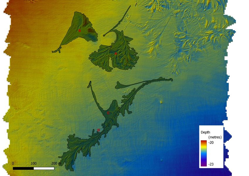
This report has been produced by Dorset Wildlife Trust using acoustic data from survey work funded by Natural
                England. Views expressed in this report are not necessarily those of Natural England

                                                  Cite this report as:

Tinsley, P., 2021. Impacts of large vessel anchoring on seabed habitats and Marine Protected Areas, s.l.: Dorset
Wildlife Trust.

                                                           2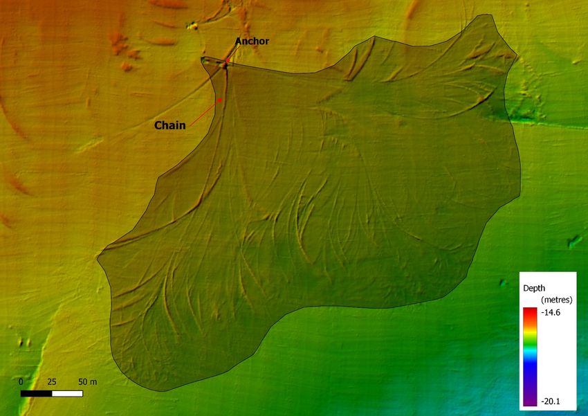
Impacts of large vessel anchoring on seabed
habitats and Marine Protected Areas
Since March 2020, a number of large cruise ships have been anchored in Poole Bay and Weymouth Bay
On 20 October, 23 cruise ships were visible in the English Channel, 15 of which were at anchor on the south coast
and one in port in Southampton. These include some of the largest cruise ships in the world, such as the Allure of the
Seas, at 360m length, a gross tonnage of 225,282t and capable of carrying over 6000 passengers. In January 2021
Dorset Wildlife Trust commissioned remote sensing surveys in Weymouth Bay and Poole Bay, with funding from
Natural England, to understand and document the impact of large vessel anchoring on seabed features and Marine
Protected Areas.

Figure 1 Screenshot from VesselFinder on 20 October 2020

The right to anchor.
Article 17 of the United Nations Convention on the Law of the Sea (UNCLOS) grants all ships the right of innocent
passage – this includes stopping and anchoring, “but only in so far as the same are incidental to ordinary navigation
or are rendered necessary by force majeure or distress or for the purpose of rendering assistance to persons, ships
or aircraft in danger or distress.”

It is reasonable to accept that the global outbreak of Covid-19 constituted a force majeure for cruise ships, leaving
them suddenly with no passengers and nowhere to go. That argument is less compelling after nearly a year.

Cruise ships were monitored using reported AIS positions as visible on VesselFinder.com. Hourly screenshots from
VesselFinder were collected between October 2020 and early January 2021, centred on Weymouth Bay (50.56N,
2.28W) and Poole Bay (50.66N, 1.9W) zoom level 12.

Weymouth Bay
Between 8 October and 28 December 2020, the following cruise ships were recorded as apparently at anchor in
Weymouth Bay:

Arcadia, Aurora, Britannia, Ventura (P&O Cruises), Marella Explorer, Marella Explorer 2, Marella Discovery (TUI UK),
Norwegian Bliss, Norwegian Encore (Norwegian Cruise Line), Queen Elizabeth, Queen Mary 2, Queen Victoria
(Cunard)

                                                           1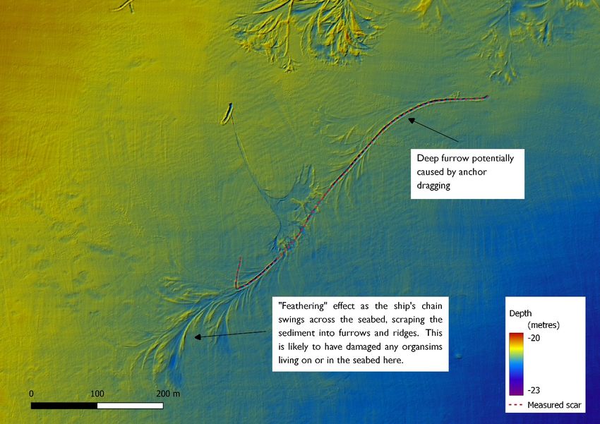
During this period the vessels either moved around or left and returned such that, between them, they appear to
have dropped anchor at least 73 times (Appendix 4)

Anchoring during the ‘ordinary course of navigation’ is part of the Public Right of Navigation making it a highly
complex issue (Griffiths, et al., 2017). There are 2 types of anchorages:

         1) those identified by and positioned within harbour authority jurisdiction

         2) those outside harbour limits which have historically been used and identified by navigational stakeholders
         led by the MCA.

Neither type of anchorage is formally recognised as being managed by any organisation and anchoring is considered
a common law right.

Weymouth Bay is a recognised anchorage, sheltered from southwesterly weather by the Isle of Portland. There are
a number of designated deepwater and hazardous cargo anchorages within the Outer Harbour of Portland Harbour,
just outside the North-eastern Breakwater. These are under the control of Portland Harbour Authority. The east
coast of Portland, from the East Ship Channel to Grove Point, also under the jurisdiction of Portland Harbour
Authority, is a no-anchoring zone and inner Weymouth Bay, from the northern limit of Portland Harbour Authority to
Redcliff Point, is under the control of Port of Weymouth.

To the east lies the Purbeck Coast MCZ/Studland to Portland SAC, in which it would be inappropriate to anchor a
large vessel other than in an emergency – though there is no de facto restriction on anchoring in MPAs. Some
anchoring has apparently occurred just over the border of the MPA – when this has happened, MMO/MCA have
requested the vessel move – though by then any damage is already done.

Between these restricted areas, there is a box of about 280ha marked on the Admiralty chart as a designated
anchorage. Some of the cruise ships have chosen to anchor within this area, but there is only room for about 4
vessels at one time – up to 8 cruise ships have been seen at one time at anchor. The presence of the cruise ships is
also displacing the occasional commercial cargo vessels and tankers that traditionally use the anchorage.

Figure 2 Cumulative image of cruise ship positions from VesselFinder.com between Oct and Dec 2020

Figure 2 is a composite image of all hourly Weymouth Bay screenshots between October and December – dark areas
indicate the density of overlapping positions, showing likely anchoring locations.

                                                                   2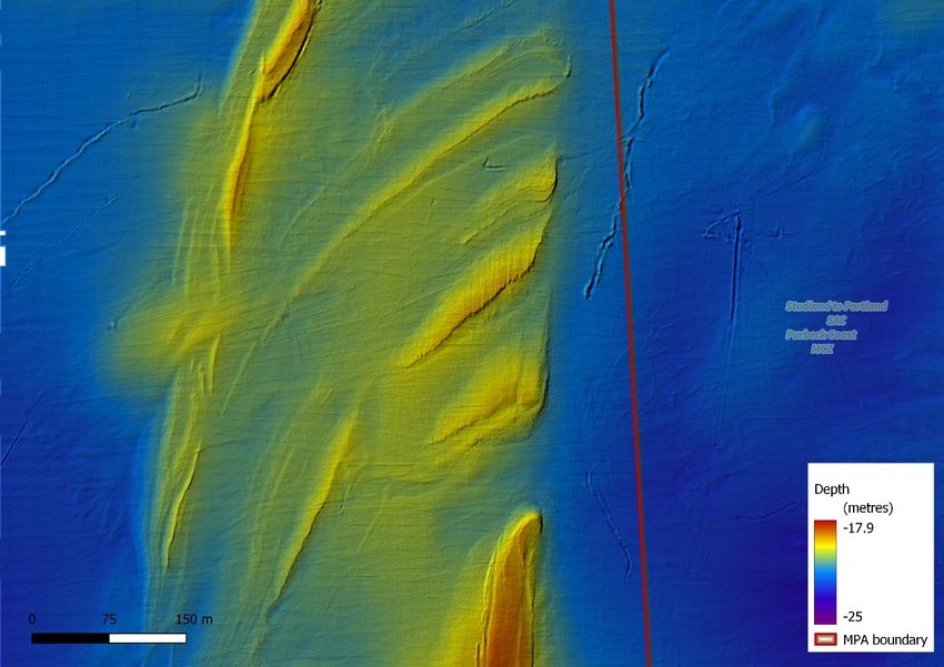
Concern has been raised about the impact of this unprecedented level and duration of anchoring of such large
vessels on the seabed. To better understand this impact and to discover if it is affecting the MPA, 3x 1km2 blocks of
multibeam sonar data were collected in early January 2021 (Appendix 6), with funding provided by Natural England.
Block 1 is within the designated anchor zone, block 2 is to the south of this and partly overlaps the anchoring areas
detected from VesselFinder and Block 3 straddles the MPA boundary where one of the cruise ships (Marella
Explorer) was seen anchoring in December.

Figure 3 Details of designated anchorage and sites of Multibeam Echosounder (MBES) survey blocks

                                                                   3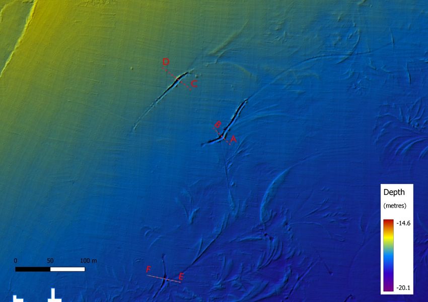
Figure 4 Location of ground-truthing photos from DORIS drop-down camera survey (Axelsson, et al., 2011) near survey blocks
Block 1
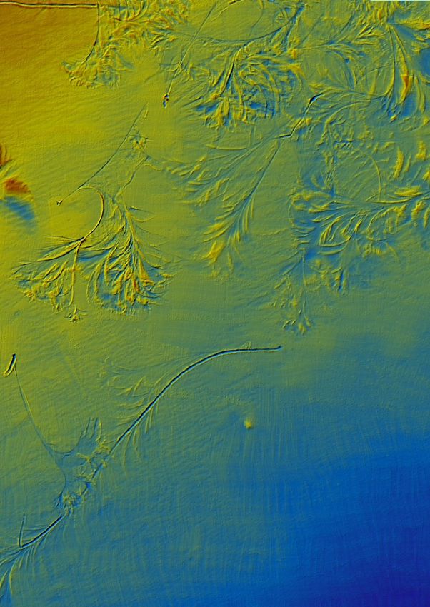
Block 1 is within the designated anchoring area. Depth ranges between 15 and 19m and the seabed is a fine
muddy sand with a stiff clay and numerous burrows. Drop video tracks C39 and C26 (Appendix 1) show the seabed
at the top and bottom of the slope. There are a number of anchor scars identifiable. Figure 5 shows a number of
deep grooves, up to 60cm deep and about 5m wide, often with a lip of raised sediment on one side. These are most
likely caused by an anchor being dragged across the seabed. A typical scar comprises a long groove where the chain
lies on the seabed with a fan of fainter marks caused by the vessel moving around the end of the anchor chain and
possibly a short (100m or so) deeper groove caused by the anchor dragging.
The extensive scar in Figure 8, radiating from a central anchoring point, covers over 6 hectares of seabed. This
corresponds to the position of the cruise ship “Aurora”, which occupied this area between 27 December and mid
January and would have been at anchor during the survey – the anchor and chain are visible in the multibeam image.
It is not certain that all of this disturbance is from one anchoring event but it is consistent with the ship initially lying
east of the anchor and shifting to a position to the south of the anchor.
4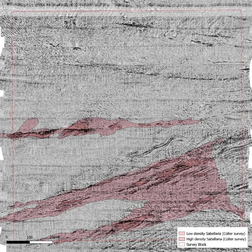
Figure 5 Deep scars in Block 1 – most likely from anchor drag

 Profile of line AB

 Profile of line CD

 Profile of line EF

                                                                5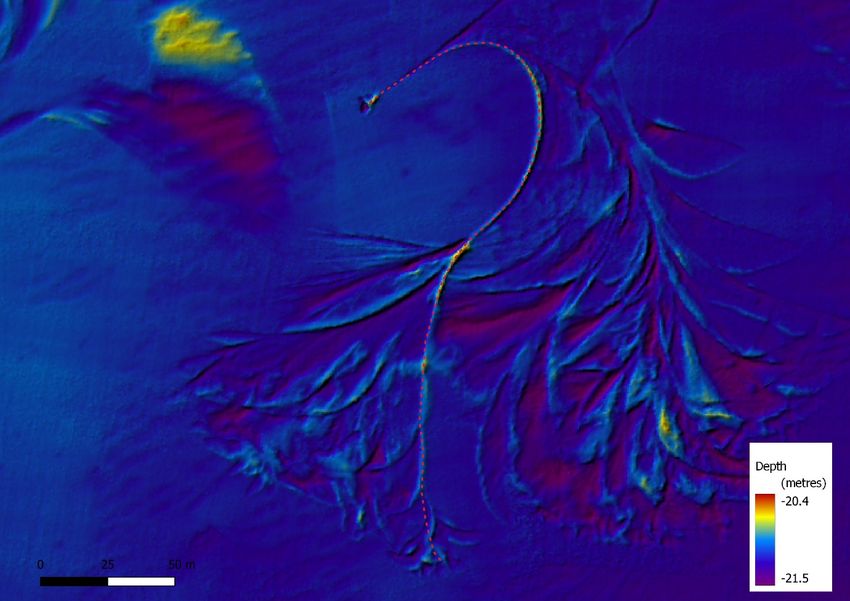
Figure 6    Profiles of lines AB, CD and EF across anchor scars. All measurements in metres

                                                                                               Scar       Length(m)
                                                                                                      1          95
                                                                                                      2         106
                                                                                                      3          67
                                                                                                      4         103
                                                                                                      5         180
                                                                                                      6         152
                                                                                                      7         191

Figure 7 Traces of anchor drag furrows in Block 1

                                                                      6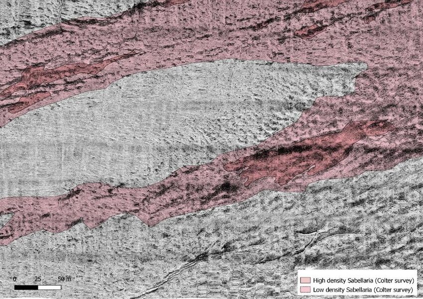
Figure 8 Extent of scarring around an anchoring location

Block 2
Block 2 is to the south of the designated anchoring area and is slightly deeper – between 20 and 22m. The seabed is
similar to Area 1, with a greater abundance of slipper limpets – see images from transect C35 (Appendix 2)

The north-east corner of this block is almost entirely impacted by anchoring( Figure 9), which gives an indication of
the cumulative effects of many anchoring events over a long period. There is little opportunity for any recovery. The
same area was surveyed in 2008 – only two faint scars were visible at that time (Figure 10).

Figure 11 shows a different scarring pattern which could be from the use of two anchors and a shorter chain. Here,
the “feathering” pattern is replaced with two almost symmetrical broad depressions and associated mounds.

Figure 12 shows a single anchor scar of 550m length, with an additional 200m of “feathering” caused by the vessel
dragging the chain across the seabed as it moves with the wind and tide. This feathering pattern is visible along
much of the length of the deeper scar, suggesting the vessel has dragged at anchor. This deeper scar is 5m wide and
about 30cm deep. This is 4 times the length of the scar attributed to the dragging of a 1 tonne anchor from a cruise
ship (Griffiths, et al., 2017).

In Figure 13      Length of anchor chain deduced from multibeam image, we can trace the full length of the chain in
contact with the seabed – this totals 267m and all but the 30m nearest the anchor have dragged across the seabed,
tracing an area out to approx. 200m from the anchor.

Figure 14 shows an attempt to calculate the area impacted by four individual anchoring events. These range from
0.9 ha to 2.7ha.

                                                           7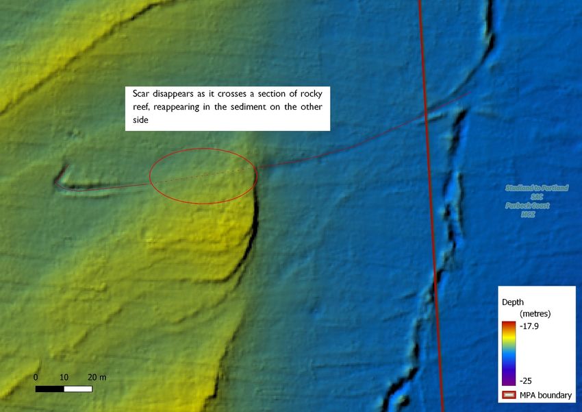
Figure 9 North-east corner of block 2, showing extensive anchor scars

Figure 10 The same area as above, from 2008. The stripe down the right hand side and adjoining curve are survey artefacts, showing the
survey vessel track.

                                                                        8
Figure 11 Twin anchor? scar alongside more typical scar
9Figure 12 A single anchor drag scar measuring 550m
Figure 13 Length of anchor chain deduced from multibeam image
10Figure 14 Attempt to calculate area of individual scars. Area A – 2.7ha, Area B – 1.5ha, Area C – 0.9ha, Area D – 2.7ha
Block 3
Block 3 straddles the boundary of the Studland to Portland SAC/Purbeck Coast MCZ. This site is between 18 and
23m deep and is a mix of sediment and exposed bedrock reefs. Ground-truthing survey tracks C36 and
C31`(Appendix 3) give a good indication of the range of habitats here.
There were occasions where vessels appeared to be anchoring within, or very close to, the protected area. On these
occasions, the vessels were requested to move. The Marella Explorer was recorded in Block 3 between from 10 to
12 October and between 8 and 11 December. There are three scars visible close to the MPA boundary - one just
crossing the boundary, one about 100m inside, and a third scar just outside the boundary. A fourth scar in the
northwest corner of the block corresponds to the recorded position of Marella Explorer between 10 and 12 October.
The MPA is designated for Annex I reef and subtidal coarse and mixed sediment. The MBES data shows the impact
on the sediment but the trail disappears where it crosses a corner of reef. This does not mean there is no impact,
just that the survey method is not able to detect it. Without knowing precisely where the anchor went down, it
would be very difficult to detect damage over reef habitat.
Marella Explorer also spent some time inside the MPA boundary about a kilometre further south, between 18 and 22
October, moving to just on the boundary for a further 2 days before moving closer to the designated anchorage. This
area was not covered in this survey.
11Figure 15 North-east corner of Block 3, showing scarring within MPA boundary
Figure 16 Showing difficulty in detecting a scar where it crosses a rocky outcrop
12Recommendations
Figure 17 Screenshot from MarineTraffic on 9 Feb 2021
On 8 February, Marella Discovery moved into the Lyme Bay and Torbay SAC to anchor just south of Bridport. It was
later joined the following day by Marella Explorer 2. This was quickly reported to MMO and a request to move was
made by MCA. Both vessels moved on 10 February, after requesting the coordinates of the MPA boundary. Marella
Discovery initially moved to a position right on the border of the Chesil Beach and Stennis Ledges MCZ.
This raises several issues:
Other than in an emergency, there should be no reason for these large vessels to drop anchor within a Marine
Protected Area, but there seems to be no legal barrier to prevent them doing so. All MPAs designated for seabed
features should have a strong legal protection from anchoring of large vessels, presuming a sensible size cut-off can
be agreed that would not affect continuing routine use by small vessels. This would require a MMO byelaw.
Related to this is the inconsistency around the marking of MPA boundaries and sensitive features on navigational
charts. Figure 17 shows the Navionics electronic chart from the MarineTraffic website. At first glance, this appears
to prohibit anchoring and fishing in Lyme Bay, but this refers to a small area, only marked at lower zoom levels, off
West Bexington, which is a submarine cable area, though no longer believed to be in use. There are a number of
areas marked with red dashed lines – some of these are military areas, but some are MPAs. On closer inspection, it
appears that Marine Conservation Zones are marked, but Special areas of Conservation are not. Based on their
behaviour elsewhere, it is possible that Marella Discovery and Marella Explorer 2 would not have anchored so far
inside the SAC, had the boundary been marked on the chart. This is something that could be easily addressed and
should be done with some urgency.
While vessels do seem to be avoiding anchoring within MPAs, there have been a number of instances where
anchoring takes place right on the border of a protected area. The multibeam data from the recent survey
demonstrates that the seabed impact can extend 500m or more from the ships position. This would suggest at least
a 500m buffer zone around any protected area or known sensitive feature. This should also be explicitly marked on
the charts.
13Poole Bay
Using hourly screengrabs from www.vesselfinder.com, we have tracked the arrivals and departures of cruise ships in
Poole Bay between 08 October 2020 and 5 Jan 2021. In that period, the following vessels were recorded: –
Jewel of the Seas, Anthem of the Seas, Explorer of the Seas, Allure of the Seas (Royal Caribbean International) and
Arcadia (P&O Cruises)
Each of these vessels spent most of the time at anchor but regularly left the bay, usually returning within a day or
two. Each time an anchor is dropped or recovered, there is the possibility of an impact on the seabed. “Arcadia”
arrived on 8 October and left within a week, without returning. The other 4 vessels weighed/dropped anchor 28
times between them over the 89 days (Appendix 5).
Figure 18 Composite image of hourly screengrabs from VesselFinder.com between October and December 2020
A composite of all of the hourly screengrabs shows where the vessels spend most of their time – see Figure 18. The
larger patches indicate where a vessel has re-anchored in the same general location – “Explorer of the Seas” spent
most of its time in the area to the south of Southbourne Rough MCZ, but other vessels were less faithful to any
particular site.
14Figure 19 Anchoring locations shown against seabed type (from HI1366)
The severity of any impact from anchoring would depend on the sensitivity of the seabed and the frequency of
anchoring. The majority of the anchoring sites seem to be associated with “Sand and gravelly sand”, which is
widespread across the bay, but they do not entirely avoid outcropping or sub-cropping bedrock and seabed features
such as rock scarps/ridges.
While most of Poole Bay has been covered by multibeam survey as recently as 2012, there is little in the way of
ground-truthing data to help locate any more sensitive habitats. The Environmental Survey (Corallian Energy Ltd,
2017) carried out prior to the oil appraisal well drilled in Poole Bay in 2018 did identify and map some sensitive
features, including Sabellaria spinulosa reefs. While Sabellaria spinulosa is widespread as an encrusting worm on rocks
and pebbles, in the right conditions, aggregations of Sabellaria worm tubes can form boulder-like concretions up to
1m across and 30cm high. This is a Habitat of Principal Importance, listed in S41 of the NERC Act 2006.
Sabellaria spinulosa reefs were first discovered in Poole Bay in 1999 about 2 miles east of Swanage and these reefs
were extensively surveyed in the early 2000s. This area is now within the Purbeck Coast Marine Conservation
Zone, though there are no recent records of healthy Sabellaria reefs from this area.
15Figure 20 From Colter (98/11-E) Appraisal Well: Environmental Statement
The central Poole Bay Sabellaria reefs were discovered in the southeast corner of the Environmental Survey study
area and it is highly likely that the feature extends further east, potentially for up to 2km, as the mapped areas of
reef seem to be associated with a seabed features visible from existing multibeam data.
16Figure 21 Mapped Sabellaria reef in relation to seabed features.
Intensity and distribution of anchoring in Poole Bay
Figure 22 shows that one anchoring cluster (“Anthem of the Seas”) coincides with the Sabellaria reef mapped by the
Colter Appraisal ES survey. The “Anthem of the Seas” occupied this area from before 8 October 2020 to 16 October
2020, at which point it moved offshore. The vessel returned to Poole Bay on 18 October 2020 but took up a
different anchoring position and has since occupied several other sites in the bay.
Figure 22 Extent of Sabellaria reef (from Colter 2018) shown over anchoring locations.
To better understand the impact of large anchors on Sabellaria reefs, 1km2 of sidescan survey data was collected
from this area on 8 Jan 2021. This was funded by Natural England.
17Results
The sidescan from 2021 matches well with that collected from the same area in 2017. Darker patches in the 2021
data line up well with the areas identified as Sabellaria reef from the Colter study. No ground-truthing has yet been
undertaken on the recent sidescan but the Colter survey results are backed up by drop-camera surveys, clearly
showing well-developed Sabellaria reef. If anything, there appear to be more textured areas, suggesting Sabellaria
reef, on the 2021 data than on the 2017, but this would need ground-truthing.
Figure 23 2021 sidescan mosaic with overlay of 2017 Sabellaria extent
A large scar, over 200m long and 5m wide, is clearly visible in the centre of the survey block. This is less than 100m
from an area characterised as “high density” Sabellaria reef in the 2017 survey. A smaller and fainter scar is visible
at the south of the survey area.
18Figure 24 Section of sidescan mosaic showing visible seabed scar.
Figure 25 Fainter scar visible at southern edge of survey block
We can date the scar as we know the vessel moved on 84 days prior to the survey – it would seem likely that much
of the scar was caused by dragging the anchor along the seabed as it was retrieved. Since that time there have been
19a number of weather events, storm Bella on 26/27 Dec being the most significant, but none of these have erased the
scar.
Figure 26 Significant wave height from Poole Bay WaveBuoy
Recommendations
The current situation is unusual and unprecedented and is happening at several sites along the south coast. Each
time one of these large vessels drops and retrieves an anchor, it is making a noticeable impact on the seabed. The
cumulative effect of this on sensitive habitats could be significant. Poole Bay seabed is generally described as largely
mobile sediments but it is far from uniform. This study has shown that at least one sensitive habitat, Sabellaria
spinulosa reef, is at risk and that scars created in what is considered coarse mobile sediment in a tideswept area are
able to persist for almost 3 months.
The arrival of these cruise ships along the south coast has brought with it an additional pressure on the marine
environment. We do not know how typical this scar is, nor do we know the sensitivity of the habitats at the other
anchoring sites. Data from multibeam survey around anchoring sites in soft mud in Weymouth Bay suggest that the
impact of anchoring is wider than that detected by this sidescan survey – there is likely to be a fan of scraped seabed
at one end of the chain scar caused by dragging of the chain at the vessel end. As the ship moves around the anchor
in different weather/tide conditions, this could impact an area of several hectares – this could have a very significant
impact on a delicate, highly localised habitat such as Sabellaria reef – the known mapped area is just over 20ha. An
unlucky anchor drop could potentially destroy a third of this.
We are concerned that the currently unprecedented level of anchoring in Weymouth Bay and Poole Bay may have
long-lasting impacts on a considerable area of seabed. While anchoring within the MPAs has mostly been limited,
the seabed outside of the MPA boundaries should not be treated as a free-for-all. It is likely that significant impact
has already occurred, this study helps indicate the potential scale of this.
We would like to see anchoring in Poole Bay restricted, at least until it is possible to better identify some sensitive
areas to be avoided, such as the recently discovered Sabellaria reefs. Figure 27 shows a suggested 500m buffer zone
around the known mapped area of Sabellaria plus the associated seabed feature.
20Figure 27 Suggested no-anchoring zone around recently discovered Sabellaria reef in Poole Bay
In the absence of more detailed survey work, the map below shows a suggested wider precautionary area to avoid,
based on a250m buffer around any rock outcrop, rock sub-crop, rock scarp or ridge identified in HI1366, or any MPA
designated for seabed features.
Figure 28 Suggested precautionary area to avoid anchoring
21We would like to see underwater noise levels monitored and kept within yet-to-be agreed thresholds.
We would like to see night-time lighting reduced as much as possible.
We would be interested to hear of any opportunities for beneficial use of these vessels while they are tied up in
Dorset’s waters – environmental monitoring, observation, survey for example.
It should be possible to accurately date some of these scars, using AIS data. Future re-survey will help determine the
longevity of such scars and the overall recovery of the site once the cruise ships resume normal operations. Diver
survey of the reef in Figure 14 might shed some light on the impact of anchoring on reef habitat and drop camera
survey of the Sabellaria reef site in Poole Bay would be useful to ascertain the continued existence of this feature.
Acknowledgements:
Multibeam and sidescan survey funded by Natural England
Maps contain data from Maritime and Coastguard Agency and Ordnance Survey, licenced under the Open
Government Licence v3.0
22Appendix 1. DORIS Drop camera images near Block 1
23Appendix 2. DORIS drop camera images near Block 2
24Appendix 3. DORIS drop camera images near Block 3
Figure 29 Drop video images - Track C31 Figure 30 Drop video images - Track C36
25Appendix 4. Log of arrivals and departures to Weymouth Bay between Oct and Dec
2020
Date Movements Anchor drops Anchor hauls
08/10/2020 Aurora, Marella Explorer, Britannia present
09/10/2020 Queen Elizabeth arrives 1
10/10/2020 Marella Discovery and Norwegian Encore arrive 2
12/10/2020 Aurora and Marella Discovery leave 2
Aurora and Norwegian Bliss arrive, Marella Explorer
14/10/2020 leaves 2 1
14/10/2020 Marella Discovery arrives 1
15/10/2020 Marella Explorer arrives 1
16/10/2020 Arcadia arrives 1
Queen Victoria arrives, Marella Explorer and
17/10/2020 Norwegian Encore leave 2 1
Marella Explorer arrives (in SAC), Norwegian Bliss
18/10/2020 moves 2 1
19/10/2020 Arcadia and Queen Victoria leave 2
20/10/2020 Marella Discovery leaves, Norwegian Bliss moves 1 2
21/10/2020 Britannia leaves 1
Marella Explorer moves outside SAC, Marella
22/10/2020 Discovery and Queen Victoria arrive 3 1
23/10/2020 Norwegian Bliss and Queen Victoria leave 2
24/10/2020 Aurora, Queen Elizabeth and Marella Discovery leave 3
Aurora, Britannia, Queen Elizabeth, Marella
25/10/2020 Discovery and Queen Victoria arrive 5
26/10/2020 Norwegian Bliss arrives, Queen Victoria leaves 1 1
Marella Explorer moves to Portland Harbour,
27/10/2020 Britannia and Marella Discovery leave 3
28/10/2020 Marella Explorer arrives, Norwegian Bliss leaves 1 1
2629/10/2020 Aurora and Britannia arrive 1 1
30/10/2020 Aurora, Britannia and Queen Elizabeth leave 3
31/10/2020 Marella Explorer leaves 1
Aurora, Marella Explorer, Britannia, Queen Elizabeth,
04/11/2020 Marella Discovery and Queen Victoria arrive 6
05/11/2020 Queen Elizabeth leaves 1
07/11/2020 Queen Elizabeth arrives 1
08/11/2020 Marella Discovery moves to Portland Harbour 1
10/11/2020 Marella Discovery arrives, Marella Explorer leaves 1 1
10/11/2020 Marella Discovery leaves 1
Norwegian Bliss arrives, Britannia and Queen Victoria
11/11/2020 leave 1 2
11/11/2020 Norwegian Bliss leaves 1
Aurora, Britannia, Marella Discovery, Norwegian Bliss
12/11/2020 and Queen Victoria arrive 5
13/11/2020 Arcadia arrives 1
13/11/2020 Aurora and Arcadia leave 2
Britannia, Queen Elizabeth, Marella Discovery,
14/11/2020 Norwegian Bliss and Queen Victoria leave 5
Aurora, Marella Explorer, Britannia, Queen Elizabeth,
16/11/2020 Marella Discovery and Norwegian Bliss arrive 6
17/11/2020 Norwegian Bliss moves to Portland Harbour 1
Marella Explorer, Britannia, Queen Elizabeth and
18/11/2020 Marella Discovery leave 4
Marella Explorer, Queen Elizabeth and Marella
19/11/2020 Discovery arrive 3
20/11/2020 Britannia arrives 1
22/11/2020 Queen Victoria arrives 1
2723/11/2020 Marella Explorer 2 arrives, Aurora leaves 1 1
25/11/2020 Marella Discovery leaves 1
27/11/2020 Aurora and Norwegian Bliss arrive 2
30/11/2020 Marella Explorer leaves 1
02/12/2020 Marella Explorer 2 leaves 1
03/12/2020 Queen Elizabeth leaves 1
Marella Explorer, Marella Explorer 2, Norwegian Bliss
04/12/2020 and Ventura arrive, Britannia leaves 4 1
05/12/2020 Aurora, Marella Explorer 2 and Norwegian Bliss leave 3
Aurora, Queen Elizabeth, Marella Explorer 2 and
06/12/2020 Queen Victoria arrive 4
06/12/2020 Queen Elizabeth leaves 1
07/12/2020 Marella Explorer 2 moves close to SAC boundary 1 1
08/12/2020 Britannia arrives 1
09/12/2020 Queen Victoria leaves 1
10/12/2020 Queen Victoria arrives 1
11/12/2020 Marella Explorer 2 leaves 1
12/12/2020 Queen Victoria leaves 1
15/12/2020 Britannia leaves 1
16/12/2020 Ventura leaves 1
16/12/2020 Queen Elizabeth and Ventura arrive 2
17/12/2020 Queen Mary 2 arrives 1
17/12/2020 Queen Elizabeth and Queen Mary 2 leave 2
18/12/2020 Ventura leaves 1
19/12/2020 Britannia, Queen Elizabeth and Ventura arrive 3
21/12/2020 Ventura leaves 1
22/12/2020 Aurora arrives 1
23/12/2020 Queen Victoria arrives 1
25/12/2020 Norwegian Bliss arrives 1
28Aurora, Britannia, Queen Elizabeth, Norwegian Bliss
26/12/2020 and Queen Victoria leave 5
Aurora, Britannia, Queen Elizabeth and Queen
27/12/2020 Victoria arrive 4
28/12/2020 Norwegian Bliss arrives 1
Total 73 75
29Appendix 5. Log of arrivals and departures in Poole Bay between October 2020 and
January 2021
Date Movements Anchor drops Anchor hauls
08/10/2020 Jewel of the Seas, Anthem of the Seas and Explorer of the Seas present
08/10/2020 Arcadia arrives, Explorer of the Seas leaves 1 1
09/10/2020 Explorer of the Seas arrives 1
10/10/2020 Allure of the Seas arrives 1
14/10/2020 Arcadia leaves 1
15/10/2020 Explorer of the Seas leaves 1
16/10/2020 Anthem of the Seas leaves 1
17/10/2020 Explorer of the Seas arrives 1
18/10/2020 Anthem of the Seas arrives 1
19/10/2020 Jewel of the Seas leaves 1
20/10/2020 Jewel of the Seas arrives 1
23/10/2020 Anthem of the Seas leaves 1
24/10/2020 Anthem of the Seas arrives 1
25/10/2020 Explorer of the Seas leaves and returns 1 1
26/10/2020 Explorer of the Seas moves close to Swanage then returns 2 1
28/10/2020 Allure of the Seas leaves, Anthem of the Seas moves 1 2
30/10/2020 Allure of the Seas arrives 1
31/10/2020 Allure of the Seas leaves, Anthem of the Seas moves 1
01/11/2020 Jewel of the Seas and Anthem of the Seas leave 2
02/11/2020 Explorer of the Seas leaves 1
Jewel of the Seas, Explorer of the Seas, Anthem of the Seas and Allure of
04/11/2020 the Seas arrive 4
05/11/2020 Anthem of the Seas moves 1 1
13/11/2020 Explorer of the Seas leaves 1
14/11/2020 Allure of the Seas leaves 1
16/11/2020 Explorer of the Seas and Allure of the Seas arrive 2
3018/11/2020 Anthem of the Seas leaves 1
20/11/2020 Anthem of the Seas arrives 1
21/11/2020 Jewel of the Seas leaves 1
22/11/2020 Jewel of the Seas arrives 1
23/11/2020 Explorer of the Seas leaves and returns 1 1
26/11/2020 Allure of the Seas leaves 1
28/11/2020 Allure of the Seas arrives 1
03/12/202 Explorer of the Seas leaves 1
04/12/2020 Explorer of the Seas arrives 1
05/12/2020 Jewel of the Seas leaves 1
07/12/2020 Jewel of the Seas arrives 1
09/12/2020 Explorer of the Seas leaves 1
15/12/2020 Allure of the Seas leaves 1
18/12/2020 Anthem of the Seas leaves 1
20/12/2020 Anthem of the Seas arrives 1
26/12/2020 Anthem of the Seas and Jewel of the Seas leave 2
28/12/2020 Jewel of the Seas and Anthem of the Seas arrive 2
04/01/2021 Jewel of the Seas leaves 1
05/01/2021 Jewel of the Seas arrives 1
Total 29 29
31Appendix 6. Hydrographic Survey Data Collection Parameters
Software Acquisition: Hypack Survey (latest update)
Processing: Hypack Survey (latest update)
Positioning Type: Single beam: CEESCOPE GPS
Multibeam: Applanix POSMV Wavemaster 2
Correction service: Trimble VRS NOW
Accuracy: 0.05 metre horizontal & vertical
Calibration: Checked against digital background data
Frequency: Static momentary position
Position: Observed to be within survey tolerance
Tides Method: RTK GPS using Trimble VRS NOW virtual tide gauge
Datum: Ordnance Datum Newlyn
CD/ODN value: -0.93 metres (Weymouth) n/a Poole (no soundings)
Presentation/XYZ To Chart Datum using the above separation value
Calibration: Checked against predicted values
MBES Type: Norbit iWBMS
Frequency: 400
Beam width (deg): 0.9 x 0.9 @400 kHz
Swathe width (degrees): Typically 130 (steered where necessary)
Resolution (metres): 0.01
Accuracy (metres): ~0.10
On-line smoothing: None
Velocity of Sound
Water column: Instrument: Valeport Swift
Sample rate: Pre, post and hourly intervals
Beam forming: Instrument: Valeport Mini SVS
Sampling rate: 1 Hz and applied in real time
Motion reference: Instrument: Applanix POSMV Wavemaster 2
Location: Factory installed within the
Sonar head
Heading reference Instrument: Applanix POSMV Wavemaster 2
Dual antenna heading reference
Calibration Verified patch test and GAMS test
Cross-referenced to single beam soundings for gross error
Processing
System: Hypack Hysweep (latest update)
Smoothing: None
Filter: Minimum beam quality: 3
Read density (metres) 0.5x0.5
Output density (metres) 0.5x0.5 Shoal bias
Output definition: One point per cell located on actual XY (where possible)
Presentation rounding: IHO Rounding Rules
Post processing: POSPac
Comment: Data has been collected to determine bed levels only
Sidescan Sonar Type: CMAX
(Poole only)
Frequency(kHz): 325 Range (m): 75
Record type: Digital
Resolution: 0.01 metres
32Accuracy (horizontal) +/- 5 metres
Accuracy (vertical) +/- 0.2m
Interpretation: None – Geotif line by line provided to client
Calibration: Opposing track target closure
Conditions and Max wave height: 0.5 metres (both sites
comments
Max swell height: 0.0 metres (both sites)
Conditions were suitable for the duration of the surveys
Bibliography
Axelsson, M., Dewey, S. & Plastow, L., 2011. Dorset Integrated Seabed Survey (DORIS) Drop-down camera (ground-
truthing) survey report, s.l.: Seastar Survey Ltd.
Corallian Energy Ltd, 2017. Colter (98/11-E) Appraisal Well: Environmental Statement, s.l.: BEIS.
Griffiths, C., Langmead, O. & Tillin, H., 2017. Anchoring and Mooring Impacts in English and Welsh Marine Protected
Areas, s.l.: Defra.
33You can also read