Cornwall Strategic Housing Land Availability Assessment Cornwall Council January 2016
←
→
Page content transcription
If your browser does not render page correctly, please read the page content below
Cornwall Strategic Housing Land
    Availability Assessment

       Cornwall Council
        January 2016

                                  1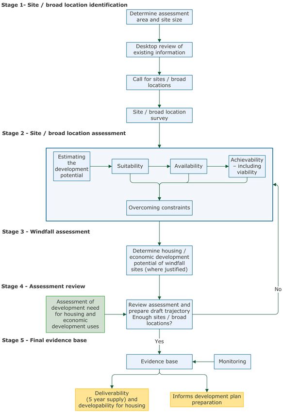
Contents
1. Introduction .....................................................................................5
  1.1 Background .................................................................................5
  1.2 Study Area ..................................................................................5
  1.3 Purpose of this Report ...................................................................6
  1.4 Structure of the Report .................................................................7
2. Planning Policy Context ......................................................................8
  2.1 Introduction .................................................................................8
  2.2 National Planning Policy Framework (2012) .....................................8
  2.3 Emerging Cornwall Local Plan .........................................................9
3. Methodology ................................................................................... 13
  3.1 Introduction ............................................................................... 13
  3.2 Updates and Baseline Date .......................................................... 13
  3.3 A Partnership Approach ............................................................... 13
  3.4 Methodology Overview ................................................................ 14
  3.5 Site / Broad Location Identification (Stage 1) ................................. 15
    3.5.1   Assessment Area and Site Size (Threshold) ............................ 15
    3.5.2   Overview of Sources............................................................ 15
    3.5.3   Planning Permissions ........................................................... 16
    3.5.4   District Local Plan and Neighbourhood Plan Allocations ............ 17
    3.5.5   Town Framework Plan Documents ......................................... 17
    3.5.6   Other Existing Sources ........................................................ 17
    3.5.7   Calls for Sites ..................................................................... 17
    3.5.8   Overlaps ............................................................................ 19
    3.5.9   Types of Sites Included........................................................ 19
    3.5.10 Desktop Review .................................................................. 20
    3.5.11 Data Management ............................................................... 20
  3.6 Estimating the Housing Potential of Each Site ................................. 20
    3.6.1   Existing Information and Urban Design Approach .................... 21
    3.6.2   Density Multiplier / Contextual Approach................................ 22
    3.6.3   Assessing When and Whether Sites are Likely to be Developed . 23
    3.6.4   Assessing the Suitability of Sites for Housing .......................... 24
    3.6.5   Assessing the Availability of Sites for Housing......................... 25
    3.6.6   Assessing the Achievability of Sites for Housing ...................... 26
    3.6.7   Build Out Rates................................................................... 28
    3.6.8   Role of Stakeholders in Assessing Deliverability and
    Developability ................................................................................. 28
  3.7 Windfall Assessment (Stage 3) ..................................................... 29
    3.7.1   Baseline Windfall Rates ........................................................ 30
    3.7.2   Anticipated Future Trends in Windfall Rates ............................ 32
    3.7.3   Progress in Windfall Delivery to Date ..................................... 34
4. Assessment Findings and Review (Stage 4) ........................................ 36
  4.1 SHLAA Sites ............................................................................... 36
  4.2 Phase 1: Cornwall Five Year Supply (2015/16 – 2019/20) ............... 36
  4.3 Phase 2: Years 6-10 (2020/21 – 2024/25)..................................... 36
  4.4 Phase 3: Years 11-15 (2025/26 – 2029/30) ................................... 36

                                                                                                     2
4.5 Phase 4: Years 16-20 (2030/31 onwards) ...................................... 36
  4.6 SHLAA Capacity by Phase and Location ......................................... 37
  4.7 SHLAA capacity by Brownfield Land .............................................. 41
  4.8 Risk Assessment......................................................................... 41
5. Summary, Conclusions, Review and Monitoring ................................... 42
  5.1 Summary .................................................................................. 42
  5.2 Conclusions ............................................................................... 42
  5.3 Review and Monitoring ................................................................ 43
6. Appendices ..................................................................................... 44
  6.1 Appendix 1: SHLAA Panel Members at January 2016 ....................... 44
  6.2 Appendix 2: SHLAA sites by Location ............................................ 46
    6.2.1  Penzance with Newlyn, Heamoor, Gulval & Longrock ............... 46
    6.2.2  West Penwith CNA Residual .................................................. 47
    6.2.3  Hayle ................................................................................ 48
    6.2.4  St Ives with Carbis Bay........................................................ 49
    6.2.5  Hayle & St Ives CNA Residual ............................................... 50
    6.2.6  Helston .............................................................................. 50
    6.2.7  Helston & The Lizard CNA Residual ........................................ 51
    6.2.8  Camborne, Pool, Redruth & Illogan ....................................... 51
    6.2.9  Camborne, Pool, Redruth & Illogan CNA Residual .................... 54
    6.2.10 Falmouth & Penryn.............................................................. 55
    6.2.11 Falmouth & Penryn CNA Residual .......................................... 55
    6.2.12 Truro with Threemilestone & Shortlanesend ........................... 56
    6.2.13 Truro & Roseland CNA Residual ............................................ 57
    6.2.14 St Agnes & Perranporth CNA ................................................ 58
    6.2.15 Newquay with Quintrell Downs ............................................. 59
    6.2.16 Newquay & St Columb CNA Residual ..................................... 59
    6.2.17 Eco-Communities ................................................................ 60
    6.2.18 St Austell ........................................................................... 60
    6.2.19 St Austell & Mevagissey CNA Residual ................................... 61
    6.2.20 St Blazey, Fowey & Lostwithiel CNA ....................................... 62
    6.2.21 China Clay ......................................................................... 62
    6.2.22 Wadebridge ........................................................................ 63
    6.2.23 Wadebridge & Padstow CNA Residual .................................... 64
    6.2.24 Bodmin .............................................................................. 65
    6.2.25 Bodmin CNA Residual .......................................................... 66
    6.2.26 Camelford .......................................................................... 66
    6.2.27 Camelford CNA Residual ...................................................... 66
    6.2.28 Bude with Stratton, Flexbury & Poughill ................................. 67
    6.2.29 Bude CNA Residual.............................................................. 68
    6.2.30 Launceston ........................................................................ 68
    6.2.31 Launceston CNA Residual ..................................................... 69
    6.2.32 Liskeard............................................................................. 70
    6.2.33 Liskeard & Looe CNA Residual .............................................. 70
    6.2.34 Callington .......................................................................... 71
    6.2.35 Caradon CNA Residual ......................................................... 71
    6.2.36 Saltash .............................................................................. 72

                                                                                                    3
6.2.37 Torpoint............................................................................. 72
  6.2.38 Cornwall Gateway CNA Residual ........................................... 73
6.3 Guide to Proportion of Undiscounted SHLAA Capacity that is Brownfield
Land 74

                                                                                               4
1. Introduction
1.1 Background
The purpose of the assessment is to identify sites within the Cornwall study area
which have the potential to accommodate housing but which do not as yet have
planning permission for residential use.
This Strategic Housing Land Availability Assessment (SHLAA) has been prepared by
Cornwall Council as part of the evidence base for the Cornwall Local Plan. This update
builds on and refreshes the previous Cornwall SHLAAs (published 2011, 2013 and
2015). Whilst the 2011 study focused solely on the main towns in Cornwall, the 2013
study both extended the coverage to smaller settlements and updated the original
assessment, compiling the results into a single report. The contents have also been
reviewed in 2015 and 2016 to incorporate additional SHLAA sites from public
submissions sites and to factor in new planning permissions and revised build out
rates. Due to the scale and nature of producing a SHLAA to cover the whole of
Cornwall, the Council took the decision to only re-assess sites from the previous
studies where more up to date information was available.
The study has been prepared by officers of Cornwall Council in consultation with a
panel of developers, agents, and public bodies. The site assessments broadly apply
the same scoring system which was developed for the 2011 SHLAA by consultants in
consultation with the then Cornish district/borough councils and local developers and
stakeholders. Subsequent amendments to the methodology have been made in
consultation with the Panel. The approach reflects the DCLG 2014 Housing and
Economic Land Availability Assessment Planning Practice Guidance. There are
instances where the methodology differs from the Planning Practice Guidance. This
has been necessary given the size of the Council – one of the largest planning
authorities in England – and the practicalities of applying the methodology at this
scale. These differences are explained in Section 3.
1.2 Study Area
The original SHLAA covered the main settlements of Bodmin, Bude, Camborne-Pool-
Illogan and Redruth, Falmouth-Penryn, Hayle, St. Ives-Carbis Bay, Helston,
Launceston, Liskeard, Newquay, Penzance-Newlyn, Saltash, St Austell-St Blazey,
Torpoint, Truro and Wadebridge.
This report updates the results for these towns but also covers the smaller towns and
villages identified in the ‘Settlements – Hierarchy and Settlement Categories Update
2012’ which is available to view on the Council’s website:
www.cornwall.gov.uk/default.aspx?page=32813. It does not however include very
small settlements which are identified as ‘open countryside’.
The latest amendments to the Cornwall Local Plan: Strategic Policies – which are
expected to be subject to public consultation commencing in January 2016 – identify
a housing requirement for each community network area (CNA) and for the main
5towns within these areas (see Figure 1). The SHLAA capacity figures have been
disaggregated on this basis.
Figure 1: Community Network Areas and Settlements with a Housing Target
in the latest amendments to the Cornwall Local Plan: Strategic Policies
1.3 Purpose of this Report
The Cornwall Strategic Housing Land Availability Assessment is a study to identify all
available sites within the study area which have the potential for future housing
development. Its primary role is to:-
• Identify available sites with the potential for housing;
• Assess each site’s housing capacity; and
• Assess when each site is likely to be developed.
The main outcomes from the SHLAA are:
• To support the Local Plan as part of the evidence base;
• An explanation of the methods, assumptions, judgements and findings of the
study;
• A list of sites quantifying the amount of housing that could potentially be
delivered on each site;
• Mapping showing the location of each site;
• The identification of constraints that could affect the delivery of the
development for each site; and
6• An indication of when each site is realistically expected to be developed based
upon an assessment of the deliverability and developability of each site in
terms of its suitability, availability and achievability for future housing
development.
Box 1: Status of the Cornwall SHLAA Report and Identified Sites
The Cornwall SHLAA is not a planning decision making document. It makes broad
assumptions in terms of site suitability in order to bring forward a wide range of sites
for consideration of housing potential. Sites that are identified in the Cornwall SHLAA
would be required to be further tested by the planning application or allocation
processes including consideration of sustainability and planning criteria, development
plan policies and consultation before they could be deemed suitable in planning
terms.
In summary:
• The SHLAA is not development plan policy;
• The SHLAA does not indicate that sites will be granted planning permission;
• The SHLAA does not preclude sites from being developed for other suitable uses;
and
• The SHLAA is an important evidence base technical document but is not a planning
decision making document.
The SHLAA does not preclude other sites which have not been submitted or assessed
during this process from coming forward for housing.
1.4 Structure of the Report
The remainder of this document sets out the assessment process and key findings
and is structured as follows:
• Section 2: Presents the planning policy context within which the assessment
has been undertaken.
• Section 3: Outlines the approach to the assessment.
• Section 4: Presents the findings of the assessment.
• Section 5: Draws together the main conclusions from the assessment and
outlines monitoring and review mechanisms.
72. Planning Policy Context
2.1 Introduction
The planning system plays an important role in delivering the development required
to meet communities’ needs as well as helping to protect the environment in our
towns and villages and the wider countryside. The development plan is a key part of
the system and local planning policy sets out the Council’s policies and proposals for
the development and use of land in the plan area. Plans are produced to control and
influence the use of land in the public interest by identifying areas where
development can and cannot take place; setting out the criteria against which
proposals will be judged, and the standards they should achieve.
2.2 National Planning Policy Framework (2012)
Published in March 2012, the National Planning Policy Framework (NPPF) distils and
revises the previous raft of national planning policy guidance down into a single
concise document. The policy approach to housing delivery emphasises the
importance of ensuring an adequate supply and choice of housing.
As with previous guidance, the NPPF advocates the efficient and effective use of land,
in locations that offer good access to a range of community facilities, key services,
employment opportunities and infrastructure. The importance of re-using previously
development land is retained.
Whilst the government has removed the regional tier of planning guidance and
devolved the responsibility for setting housing targets down to unitary and district
authorities, the NPPF sets out strong guidance on the considerations for setting
housing figures.
Councils need to ensure that their Local Plans meet the ‘full, objectively assessed
needs for market and affordable housing in the housing market area’, identifying and
updating annually a supply of deliverable sites sufficient to provide 5 years’ worth of
housing with an additional buffer of 5% to ensure choice and competition. Where
there is a persistent record of under delivery an additional 20% buffer is required.
Beyond the first five years the NPPF requires Local Authorities to ‘identify specific,
developable sites or broad locations for growth, for 6-10 years and, where possible,
for years 11-15’.
The NPPF also sets out policy provisions for neighbourhood plans. These have to be in
conformity with the Local Plan, and whilst they can put forward higher levels of
development they cannot be used as a tool to promote a lower level of provision in
their area.
In planning for housing, there are a number of other key considerations that need to
be taken into account. The government recognises that managing flood risk,
minimising pressures on water and waste infrastructure, and conserving and
enhancing green space and biodiversity are all important concerns, as is design
8quality for helping to create successful and sustainable places. The government
considers that more homes are needed across the whole country, in both urban and
rural areas.
The strategic housing role is at the heart of local authority place shaping – creating
vibrant mixed communities by ensuring that the right housing, of the highest quality,
is in the right place with the necessary infrastructure and support.
Local authorities are required to prepare a SHLAA to establish realistic assumptions
about the availability, suitability and the likely economic viability of land to meet the
identified need for housing over the plan period. Guidance on how a SHLAA should be
prepared is set out in ‘Housing and economic development needs assessments’
Planning Practice Guidance 1.
2.3 Emerging Cornwall Local Plan
The Cornwall Local Plan – together with national planning policy and neighbourhood
plans – will provide the planning framework for development in Cornwall. It will set
out the Council’s planning policies for meeting the county’s economic, environmental
and social aims for the future.
In the light of the abolition of the South West Regional Spatial Strategy and the
publication of the NPPF, which now takes precedence where the local plan is ‘absent,
silent or relevant policies are out-of-date’, the Council has found that it is appropriate
to refer to the emerging Cornwall Local Plan in consideration of proposals, along with
other saved policies but will consider the weight to be given, particularly where there
appears to be a conflict with the NPPF. It is proposed to follow the Local Plan:
Strategic Policies with a site allocations document. The SHLAA evidence will have
particular relevance to that document in helping to identify what site specific options
are available.
The 2015 Cornwall Local Development Scheme 2 states that the list of Cornish
Development Plan Documents will comprise:
• Cornwall Local Plan: Strategic Policies DPD – Sets out the spatial vision, objectives
and strategy for the spatial development of Cornwall and strategic policies and
proposals to deliver the vision for the period to 2030. It provides the Council’s
policies for meeting the county’s economic, environmental and social aims for the
future, where this effects the development and use of land.
• Cornwall Local Plan: Site Allocations DPD – Allocates sites required to meet growth
targets in the Local Plan: Strategic Policies document.
• Cornwall Local Plan: Travelling Communities Site Allocations DPD – Allocates sites
to meet the needs of travelling communities identified in the Local Plan.
1
http://planningguidance.communities.gov.uk/blog/guidance/housing-and-economic-
development-needs-assessments/
2 http://www.cornwall.gov.uk/environment-and-planning/planning/planning-policy/adopted-
plans/local-development-scheme/
9• Cornwall Local Plan: Minerals Safeguarding DPD – Sets out non-strategic policy for
safeguarding.
• Local Plan: Policies Map DPD – Ordnance Survey based map representing site
specific policies.
• Neighbourhood Plans – Prepared by city, town or parish councils to address local
priorities and provide local policies and allocations as decided by the local council,
best in consultation with Cornwall Council.
The emerging Cornwall Local Plan: Strategic Policies was submitted to the Secretary
of State for examination on 6th February 2015, having been through Issues and
Options, Preferred Approach, Pre-Submission, Proposed Submission and Focused
Changes consultations. The hearings for the examination commenced in May 2015
and were later suspended to enable further work to be undertaken on issues
including objectively assessed need.
Following the latest statement on objectively assessed need3, proposed amendments
to the housing target and distribution were approved for future consultation by
Cornwall Council on 15th December 2015. The proposed amended housing target is
52,500, with a distribution as set out in Table 1.
Table 1: Local Plan Proposed Amended Housing Distribution
Emerging Local Plan
Location
Housing Target
Penzance with Newlyn, Heamoor, Gulval and Longrock 2,150
West Penwith CNA residual 1,000
CNA Total 3,150
Hayle 1,600
St Ives with Carbis Bay 1,100
Hayle and St Ives CNA residual 480
CNA Total 3,180
Helston 1,200
Helston and the Lizard CNA residual 1,100
CNA Total 2,300
Camborne, Pool, Illogan & Redruth 5,200
CPR CNA residual 1,000
CNA Total 6,200
Falmouth-Penryn 2,800
Falmouth and Penryn CNA residual 600
CNA Total 3,400
Truro with Threemilestone and Shortlanesend 3,900
Truro and Roseland CNA residual 1,200
3
https://democracy.cornwall.gov.uk/ieListDocuments.aspx?CId=584&MId=6650&Ver=4 (see
item 5.1, Appendix 2)
10Emerging Local Plan
Location
Housing Target
CNA Total 5,400
St Agnes & Perranporth CNA Total 1,100
Newquay with Quintrell Downs 4,400
Newquay and St Columb CNA residual 400
CNA Total 4,400
Eco-Communities 1,500
St Austell 2,600
St Austell CNA residual 300
CNA Total 2,900
St Blazey, Fowey and Lostwithiel CNA Total 900
China Clay CNA Total 1,800
Wadebridge 1,100
Wadebridge and Padstow CNA residual 1,000
CNA Total 2,200
Bodmin 3,100
Bodmin CNA residual 100
CNA Total 3,200
Camelford 315
Camelford CNA remainder 685
CNA Total 1,000
Bude with Stratton, Flexbury and Poughill 1,200
Bude CNA residual 600
CNA Total 1,800
Launceston 1,800
Launceston CNA residual 500
CNA Total 2,300
Liskeard 1,400
Liskeard and Looe CNA residual 1,500
CNA Total 2,900
Callington 480
Caradon CNA remainder 520
CNA Total 1,000
Saltash 1,200
Torpoint 350
Cornwall Gateway CNA residual 350
CNA Total 1,900
TOTAL: 52,500
11The SHLAA is a component of the evidence base supporting the delivery of sufficient
land to meet the community’s need for more housing. While the SHLAA does not in
itself determine whether a site should be allocated for housing development, its
evidence plays a key role in underpinning the Local Plan by helping to identify the
choices available in meeting the scale and distribution of housing proposed.
123. Methodology
3.1 Introduction
The approach to the assessment of housing potential in Cornwall follows the
Department for Communities and Local Government (DCLG) (2014) Housing and
Economic Land Assessment Planning Practice Guidance1 which sets out the broad
methodology for undertaking assessments to identify the capacity of potential
housing sites within a study area.
3.2 Updates and Baseline Date
This review provides an update to the documents previously produced, namely:
• ‘Cornwall Council Strategic Housing Land Availability Assessment March 2011’
(baseline December 2009);
• ‘Cornwall Strategic Housing Land Availability Assessment September 2013’
(baseline 1st April 2013); and
• ‘Cornwall Council Strategic Housing Land Availability Assessment February
2015’ (baseline 1st April 2014).
The baseline for the updated study is 1st April 2015. This date is used as a cut-off for
the removal of land with residential planning permission from the SHLAA and it
corresponds with the baseline for updates to the housing trajectories and five year
land supply. Nevertheless, appropriate SHLAA submissions received since 1st April
2015 are also reflected in the SHLAA.
3.3 A Partnership Approach
The DCLG Guidance advocates a partnership approach, involving key partners from
the outset. Reflecting this guidance (also promoted in the 2007 DCLG Strategic
Housing Land Availability Assessments Practice Guidance), the original SHLAA
methodology was agreed by the former local authorities in Cornwall in November
2008 following extensive consultation including neighbouring authorities during a six
week period between 15th August 2008 and 29th September 2008. This consultation
comprised two key elements:
• First, the methodology was sent to key agencies (known collectively as the
SHLAA Panel), including the Environment Agency, Natural England, the
Highways Agency, house builders, housing associations, parish councils,
developers and landowners; and
• Second, the methodology was made available on each of the former LPAs’
websites. Comments from stakeholders were analysed and the methodology
amended as appropriate prior to formal agreement by the former district
councils in November 2008.
During the preparation of the 2013 SHLAA Report, the Council decided to make minor
changes in the approach, drawing on the experience of the original study. An
expanded Panel was able to comment on both the process and the additional sites
13included before the report was finalised. The Panel have also been consulted on the
additional sites included subsequently as well as amendments to the build out rates
(see 3.6.8). Panel membership is set out at Appendix 6.1.
3.4 Methodology Overview
The 2014 DCLG guidance identifies five main stages to the assessment as shown in
Figure 2 below.
Figure 2: SHLAA Process As Shown in the 2014 DCLG Guidance on Housing
and Economic Land Availability Assessment
14The following sections explain the process undertaken in relation to the stages set
out above for this assessment.
3.5 Site / Broad Location Identification (Stage 1)
3.5.1 Assessment Area and Site Size (Threshold)
The local planning authority area is the entirety of the county of Cornwall not
including the Isles of Scilly which has a separate unitary authority. This has been
used as the geographic area for the SHLAA and reflects the approach of the Strategic
Housing Market Needs Assessment (2013) for the sub-region which works to the local
planning authority boundaries.
The first Cornwall SHLAA Report was published in 2011 and focused on the main
Cornish towns of Penzance, Newlyn, Carbis Bay, St Ives and Hayle, Helston,
Camborne, Redruth, Illogan and Pool, Truro, Falmouth and Penryn, Newquay, St
Austell and St Blazey, Bodmin, Wadebridge, Launceston, Bude, Saltash, Liskeard and
Torpoint. This included work previously undertaken by Kerrier District Council on a
SHLAA for Camborne, Redruth, Illogan and Pool in 2009. These settlements reflect
the “Strategic Urban Centres” and “Other Main Towns and Centres” identified in the
2004 Cornwall Structure Plan which has since been revoked.
The second SHLAA Report was published in 2013. It updated the 2011 version and
also extended the remit to the whole of Cornwall. The subsequent updates maintain
the Cornwall-wide coverage.
The 2014 DCLG Guidance states that a SHLAA should consider all sites capable of
delivering five or more dwellings although it also advises that alternative thresholds
may be considered where appropriate. Correspondingly, a site size threshold of 5
units or 0.1ha was applied for the 2009 Camborne/Pool/Illogan/Redruth SHLAA and
the 2011 Cornwall SHLAA.
Due to Cornwall being one of the largest local authority areas in England, with a vast
number of sites involved, it was decided that for the 2013 report onwards to focus
the limited resources on those sites exceeding 0.2 hectares or where it is anticipated
that a site has the capacity for a minimum of ten dwellings. This also provides
consistency with the Council’s annual housing trajectories. Sites submitted below this
threshold are held on record and can be reviewed later.
Due to the capacity of specific sites identified within this report (see Section 4) it was
not deemed necessary to consider broad locations.
3.5.2 Overview of Sources
A number of sources of information have been reviewed in order to inform the
assessment as set out in Table 2.
15Table 2: Capacity Sources
Capacity Source Origin
Planning Permissions Outline/Full Planning Permissions (not yet
NB These sites feature in the five delivered).
year land supply – not the SHLAA
Pending applications Pending applications
Expired Planning Permissions Expired Planning Permissions
Local Plan Housing Allocations Local Plan Housing Allocations
Local Plan Mixed Use Sites Local Plan Mixed Use Sites
Draft Area Action Plans Truro and Threemilestone AAP
Town Framework Plan Documents Penzance/Newlyn, Hayle, St Ives/Carbis Bay,
Camborne/Pool/Redruth, Newquay, Bude,
Launceston, Liskeard and Saltash Town
Frameworks
Masterplans Bodmin Masterplan
Regeneration Plans St Austell Regeneration Plan
Neighbourhood Plans Advanced neighbourhood plans
Eco-community information Plans for eco-communities at West Carclaze
(pending application) and Par
Affordable Housing Projects Includes Priority Parish work and Community
Land Initiative
Emerging LDF Sites from former Council LDF Preferred Options
District Councils Council LDF Preferred Options – Residential /
Mixed Use
Council LDF Preferred Options – Direction of
future growth
Regeneration Sites
Urban Capacity Sites Urban Capacity Study (2008)
Affordable Housing Land Availability Restormel BC AHLAA
Assessment
Planning Application Refusals & Planning Application Refusals & Withdrawals
Withdrawals
Surplus Public Sector Land Empty Property Register (SHLAA 2011)
Register of Surplus Public Sector Land
Surveys Sites HLA Survey 2008
National Land Use Database (NLUD)
2006 Sites
English House Condition Survey
Officer Knowledge
OS Maps / Aerial Photographs
Call for Sites Calls for sites (see 3.5.7)
3.5.3 Planning Permissions
The schedule of planning permissions has been kept up-to-date within the five year
land supply statement as a part of the Council’s authority planning annual monitoring
report (AMR). Any sites that have gained planning permission have been removed
from the SHLAA to avoid double counting.
163.5.4 District Local Plan and Neighbourhood Plan Allocations
Existing allocations are identified in the housing trajectory with an assessment made
of likely deliverability.
3.5.5 Town Framework Plan Documents
Town Framework Plans were prepared for the main Cornish towns together with a
Regeneration Plan for the St Austell area. They are non-statutory plans which provide
part of the evidence base for the Local Plan and have been consulted on alongside
the plan. The Town Framework Plans used Cornwall SHLAA 2010 sites as evidence
along with newly identified sites. A selection of sites from the Town Framework Plans
appear in the trajectories. These include sites which are also within the SHLAA so
care must be taken to avoid double counting.
3.5.6 Other Existing Sources
A number of additional sources of sites with the potential for significant levels of
housing capacity were also identified by the Council for inclusion within the housing
trajectory and SHLAA. Additional sources included Council-led regeneration
initiatives, Council property disposal, eco-community development, various affordable
housing led projects and initiatives, pending planning applications, sites identified as
part of the existing evidence base (e.g. urban capacity studies) as well as those sites
identified during street-by-street surveys. The estimated housing capacity of each of
the categories was calculated using an agreed density multiplier where existing
indicative capacity information was not available.
3.5.7 Calls for Sites
The calls for sites give landowners, developers and agents a specific opportunity to
put forward sites for inclusion in the SHLAA. Letters are sent to developers, agents
and specific land owners and the calls for sites are advertised on the Council website
and in the local press to maximise publicity to those not normally involved in
property development (as advised in the 2014 DCLG Guidance). Calls for sites
require details of land to be submitted on set SHLAA forms and to be accompanied by
a map, plan or aerial photograph clearly showing the boundaries of each site.
The original ‘calls for sites’ (2007-2009) for the 2011 SHLAA Report were conducted
individually by the six former district councils. A new call for sites was made in
January 2012 to coincide with the consultation on the Core Strategy Preferred
Approach. This helped to maximise the publicity for the exercise. This call extended
the coverage to the smaller settlements and rural areas and was also used as a
refresh for the main towns to build on and update the original SHLAA calls for sites.
The Council has since welcomed site suggestions on an ongoing basis as well as
through a call for brownfield sites held in 2015.
The advertised dates for each specific settlement’s ‘call for sites’ exercises are
included in Table 3.
17Table 3: Call for Sites Schedule
1st Call for 2nd Call for 3rd Call for
Authority Settlement
Sites Sites Sites
Former Penzance/Newlyn, Aug – Sept Aug – Sept Jun – July
Penwith DC St Ives/Carbis 2007 2008 2009
Bay & Hayle
Former Kerrier Camborne/Pool/ April 2008 Further sites received during
DC Redruth AAP process 2008/2009
Helston Jun – Jul 2009
Former Carrick Truro Dec 2008 – Jun – Jul 2009
DC Feb 2009
Falmouth/Penryn Jun – Jul 2009
Former St Austell/St Aug – Sep
Restormel BC Blazey & 2007
Newquay and
rural areas
(AHLAA – see
Table 2)
Former North Bodmin, Dec 2008 –
Cornwall DC Launceston, Jan 2009
Wadebridge &
Bude
Former Saltash/Torpoint Nov – Dec
Caradon DC & Liskeard 2008
Cornwall Cornwall-wide Jan – Feb Aug – Sep (Sites
Council (assessment 2012 2015 accepted on
focuses on those (targeting an ongoing
in the settlement brownfield basis)
hierarchy) land)
The 2014 DCLG Guidance suggests that authorities can specify the nature of
information sought e.g. potential types of development including tenures, types and
needs of different groups such as older people housing, private rented housing and
people wishing to build their own homes. This level of information has only recently
been sought by the Council. The preliminary nature of many of the SHLAA submission
proposals are that there are no firm tenures decided upon and the Council does not
have the resources to consider this level of detail for each site. Nevertheless tenure
information is now requested on SHLAA submission forms and can be assessed in the
future. Furthermore, the SHLAA process has included consideration of viability and
housing for older people and students is included in the commitments in Phase 1
(years 0-5) of the housing trajectory where planning permission has been granted.
Despite the recent targeted call for brownfield land, Cornwall Council continuously
welcomes SHLAA submissions (greenfield and brownfield) providing details of
additional sites or updates to previous submissions.
183.5.8 Overlaps
A number of sites have been submitted more than once as part of various studies
and calls for sites that have taken place over time. It was important that these
entries were identified to eliminate occurrences of double counting in the final SHLAA
figures. Priority was given to the latest call for sites submission if more than one was
submitted or the larger site where a smaller site entirely overlaps a larger site. If a
site was submitted as part of a SHLAA call for site process then it would typically be
these entries that would be given priority resulting in the deletion of the duplicate
sites from any other SHLAA source. To avoid overlaps with accounting in the five year
land supply, no sites with extant planning permission for residential use are included
in the SHLAA.
3.5.9 Types of Sites Included
There are many hundreds of settlements in Cornwall, ranging from those that are
strategically significant such as Truro, through small towns and local service centres
to the smallest of villages and hamlets. Many of Cornwall's towns and villages are
well-placed to meet the challenges of the next few decades because they are already
relatively self-sustaining and contain strong communities.
Prior to undertaking detailed assessments of specific sites, it was necessary to
undertake a screening exercise or “sieve” of sites in order to identify those not
suitable for inclusion within the assessment. This sieve comprised the application of a
site size threshold (see Section 3.5.1) and omission of sensitive areas. The excluded
areas are listed in Box 2 below and include land within a Special Areas of
Conservation (SAC), Special Protection Area (SPA) and Site of Special Scientific
Interest (SSSI). These designations have been excluded on the basis that national
policy advises against development that would have an adverse impact on such
nationally or internationally important conservation interests.
Some sites included within the assessment may be close to but not within particularly
sensitive designations. In reality a site close to these sensitive locations might have a
reduction in their capacity but this would require a detailed assessment which is more
appropriate for the planning application stage, therefore in this study unless
alternative figures have been supplied by the landowner their capacity has been
assessed using the standard density multiplier set out at 3.6.3.
Land within areas identified as Flood Risk Zone 3b was also excluded, as consistent
with national policy advice that only water compatible uses and essential
infrastructure should be permitted in these areas.
Rather than completely omit a site that lies partly within a SAC, SPA, SSSI or Flood
Risk Zone 3b, it was agreed that only the site area that fell outside such designations
would be used to calculate capacity. Capacity was also reduced where a site has
already been partially developed.
Consideration has also been given to the potential impact of individual SHLAA sites
becoming developed in the setting of the AONB. An additional study applies
discounting for sites within the AONB and those in Flood Zone 3a as well as a non-
19implementation rate. Section 4.8 provides further information on both of these
studies.
Consistent with the NPPF and emerging Local Plan, land within the open countryside
has been excluded from the SHLAA. In practice sites were included if it constituted
land that was considered to be within or physically connected to a settlement as
defined by the Cornwall settlement hierarchy. For further information on the
settlement hierarchy visit: www.cornwall.gov.uk/localplancornwall.
Land with planning permission was also excluded for reasons explained at 3.5.3.
Box 2: Land Excluded from the Survey
Special Area of Conservation
Special Protection Area
Site of Special Scientific Interest
Flood Risk Zone 3b
Open Countryside (i.e. land not in or well integrated with existing built-up areas)
Land with extant residential planning permission
NB Sites submitted completely within these areas have not been progressed within
the SHLAA although the submissions have been held on record for future reviews.
3.5.10 Desktop Review
For each site the following characteristics were recorded or checked as part of the
desktop review:
• Site size, boundaries, and location;
• Current use(s) and character;
• Character of surrounding area and the surrounding land use(s);
• Physical constraints;
• Potential environmental constraints;
• Where relevant, development progress;
• Suitability of residential use; and
• Viability.
3.5.11 Data Management
The boundaries of each site were digitised using a GIS system and site details
entered into a database. A unique reference number was assigned to both the spatial
(GIS) and textual (spreadsheet) information on a site. All sites were assembled on a
CNA basis. Sites were allocated to the CNA within which its respective settlement
primarily sits. Site Assessment (Stage 2)
3.6 Estimating the Housing Potential of Each Site
A combination of the following methods was used to determine the potential housing
capacity of each site:
• Existing information;
20• Density multiplier;
• Contextual approach;
• Submission responses; and
• Urban design approach.
Table 4 provides details of how the density for each specific capacity source was
derived.
Table 4: Density Calculation
Capacity Source Density Derived from…
Pending Applications (for five year supply) Submission Information
Expired Planning Permissions Density Multiplier / Contextual Approach
Local Plan Housing Allocations Existing Information / Density Multiplier
/ Contextual Approach
Local Plan Mixed Use Sites Existing Information / Density Multiplier
/ Contextual Approach
Draft Area Action Plans Existing Information / Urban Design
Approach
Town Framework Plan Sites Existing Information / Urban Design
Approach
Bodmin Masterplan Existing Information / Urban Design
Approach
St Austell Regeneration Plan Existing Information / Urban Design
Approach
St Austell and China Clay Eco Community Existing Information / Urban Design
Approach
Affordable Housing Projects Density Multiplier / Urban Design
Approach
Emerging LDF Sites from former District Existing Information / Urban Design
Councils (SHLAA 2011) Approach
Urban Capacity Sites Existing Information
Affordable Housing Land Availability Density Multiplier
Assessment
Planning Application Refusals & Density Multiplier / Contextual Approach
Withdrawals
Surplus Public Sector Land Density Multiplier / Contextual Approach
Surveys Sites Density Multiplier / Contextual Approach
Call for Sites Density Multiplier / Submission
Responses
Further information on each approach is discussed in-turn below.
3.6.1 Existing Information and Urban Design Approach
Existing capacity information was used where this was available from sources such as
pre-application discussions; development briefs, master plans and local housing
allocations with identified indicative capacities. For some large or strategic sites, an
urban design approach was used although in reality this information could be classed
under ‘existing information’ as the urban design analyses were undertaken for sites
in relation to the Area Action Plan process and existing master plans.
213.6.2 Density Multiplier / Contextual Approach
Where existing density information was not available or only available from the
landowner as part of a SHLAA submission, a density multiplier was applied to sites.
For the 2013 study onwards a revised set of multipliers was developed, adding a new
category for rural locations and slightly revising upwards the figure for the main
towns following the original 2011 SHLAA as set out in Box 3. The density multipliers
broadly reflect the densities sought by the former district authorities which were
generally in the range of at least 30 – 50 dwellings per hectare. Not all of the plans
specified density in policy and not all policies were saved. The emerging Local Plan
does not specify residential densities. The 2014 DCLG Guidance on SHLAA
preparation advises that where plan policy does not provide a sufficient basis to
make a judgement, existing development schemes can be used as the basis for
judgement.
Box 3: Density Multipliers
Within Town Centre Boundaries: 60dph – same as per SHLAA 2011
Main Towns: 50dph – subsequently increased from the 45dph in SHLAA 2011
because this was considered too low (e.g. more propensity for flats) and to allow
gradation down to suburban and rural areas. The list of settlements was also
expanded from the RSS “significant” towns to include those with a strategic role in
the emerging Local Plan
o Truro
o Falmouth & Penryn
o Camborne
o Pool
o Redruth
o St Austell
o Newquay
o Bodmin
o Launceston
o Saltash
o Penzance & Newlyn
Smaller Towns: 45dph – increased from 40dph in SHLAA 2011 as this was
considered too low and to allow gradation down to rural areas
o Bude with Stratton & Poughill
o Hayle
o Helston
o St Ives & Carbis Bay
o Liskeard
o Wadebridge
o Torpoint
Rural: 40dph –
o All other locations
The density assumptions presented above have been used to provide an estimate of
potential housing capacity only and do not necessarily reflect the density of housing
to be provided on site which will be the subject of additional examination through any
allocation process and/or for future planning applications.
22In order to determine the net developable area of sites without existing information
and enable a calculation of potential capacity, a further assessment was undertaken
to determine the need for, and the amount of, other infrastructure that may be
required on sites of varying size, such as roads, open space, trees etc. and the
calculation shown in Table 5 was applied.
Table 5: Net Developable Area
Number of Dwellings (whole site) Area of Site Developed for Housing
Below 25 units Whole site could be developed for
housing
25 to 50 Units 85% of site (net) developed for housing
Over 50 units 70% of site (net) developed for housing
For the purposes of SHLAA reporting, the calculated capacity was considered to be a
maximum level of housing. Where the calculated capacity exceeds the capacity given
on a SHLAA submission form, the figure in the submission was used.
3.6.3 Assessing When and Whether Sites are Likely to be Developed
Having established the capacity figure for individual sites, the next stage in the
assessment was to establish whether a site can be considered deliverable,
developable or not currently developable for housing development which in turn
would inform assumptions with respect to when each is likely to come forward.
Box 4 provides a definition as to what constitutes deliverable, developable and not
currently developable sites in the context of this SHLAA together with when such
sites are expected to come forward based on the phasing set out in the NPPF.
Box 4: Deliverability and Developability and Phasing
Deliverable – site is available now, offers a suitable location for housing
development now is achievable and there is a realistic prospect that it will be
delivered within 5 years and in particular that development of the site is viable. Sites
with planning permission should be considered deliverable until permission expires,
unless there is clear evidence that schemes will not be implemented within five
years, for example they will not be viable, there is no longer a demand for the type
of units or sites have long term phasing plans.
Developable – a site should be in a suitable location for housing development, and
there should be a reasonable prospect that it will be available and could be developed
at a specific point in time (years 6 to 10 and where possible years 11 to 15).
Not currently developable – it is unknown when a site could be developed. This
may be, for example, because of the constraints to development is severe, and it is
not known when it might be overcome.
The assessment of sites involved a judgement of when and whether sites were likely
to come forward for development, based on their suitability, availability and
achievability. A representation of the methodology and processes involved in the
classification of individual sites can be found in more detail in Table 6. Due to the
scale of the Cornwall SHLAA it was not possible with the resources available to
23consider how to overcome potential barriers on individual sites. Those sites scoring
poorly in terms of suitability, availability and achievability were however shifted into
a later phase in order to enable more time for potential barriers to be overcome.
Table 6: Suitability, Availability and Achievability of Sites
Suitability Availability Achievability
- Policy restrictions - Planning - Market factors
Designations / protected application/allocation Adjacent uses/ economic
areas / existing planning viability of existing,
policy / sustainable - No legal or ownership proposed and alternative
community policy problems uses in terms of land
Multiple ownership / values / attractiveness of
- Physical problems or ransom strips / tenancies / locality / level of potential
limitations operational requirements market demand /
Access / infrastructure / of landowners projected rate of sales
ground conditions / flood
risk / hazardous risks / - Interest to develop - Cost factors
pollution / contamination Land owner expressed an Site preparation relating to
intention to develop physical constraints / any
- Potential impacts exceptional works
Effect upon landscape necessary / relevant
features and conservation planning standards or
obligations / prospect of
- Environmental funding or investment to
conditions address identified
Which would be constraints or assist
experienced by prospective development
residents
- Delivery factors
Developers phasing /
realistic build out rates on
larger sites / likely start
and completion dates /
single or multiple
developers / size and
capacity of developer
Each stage above is described in more detail in the following sections.
3.6.4 Assessing the Suitability of Sites for Housing
DCLG Guidance states sites in existing development plans or with planning
permission will generally be considered suitable for development although it may be
necessary to assess whether circumstances have changed which would alter their
suitability. This is checked as part of the housing land review process – the
information is gathered either by contacting the developers direct or asking the
relevant Development Management officers if there has been any updated since
permission granted. For all sites the guidance lists a range of factors to be
considered in assessing a site’s suitability:
• The development plan, emerging plan policy and national policy;
24• Market and industry requirements in that housing market;
• Physical limitations or problems such as access, infrastructure, ground
conditions, flood risk, hazardous risks, pollution or contamination;
• Potential impacts including the effect upon landscapes including landscape
features, nature and heritage conservation;
• Appropriateness and likely market attractiveness for the type of development
proposed;
• Contribution to regeneration priority areas;
• Environmental/amenity impacts experienced by would be occupiers and
neighbouring areas.
The Cornwall SHLAA methodology applies a two stage approach to assessing the
suitability of a site. The first stage as described at 3.5.9 consists of assessing sites
against a range of strategic considerations (flood zone, located in open countryside
etc.). If a site fails this initial stage, it is deemed to be an unsuitable location for
housing development and does not proceed to the more detailed second stage
assessment.
The second stage assessment consists of checking sites against a wider range of
development factors. Those factors include the following designations and attributes
• Conservation Areas • Greenfield / brownfield
• Historic Battles • Flood Zone
• Listed Buildings • Topography
• Scheduled Ancient Monument • Site access
• World Heritage Site • Contamination
• Landscape Character Area • Neighbouring uses
• AGLV • Drainage capacity
• AGSV • Open space / recreational
• Ancient Woodland facilities
• Historic Parks and Gardens • Employment land
• Local Nature Reserve • Distances to primary and
• County Wildlife Sites secondary schools
• RIGG • Distances to an A or B Road
• TPO • Distance town centre (town sites
• AONB only)
• Agricultural land grades • Public rights of way
• Minerals • Relationship to settlement
consultation/safeguarding area
Sites that were considered to be suitable were then assessed in terms of their
availability and achievability.
3.6.5 Assessing the Availability of Sites for Housing
The DCLG Guidance states that a site is considered available when, on best
information available, there is confidence that there are no legal or ownership issues.
This often means that the land is controlled by a developer has expressed an
intention to develop housing or the land owner has indicated an intention to sell.
Deliverable sites are those coming forward in the first 5 years. There needs to be
evidence that they are available now. These sites are featured in the five year land
25supply statement, with delivery of sites with planning permission being informed by
developers/agents where possible (otherwise standard build-out rates were applied).
These sites do not feature in the SHLAA unless they have been granted planning
permission since the baseline date of 1st April 2015. The SHLAA only includes sites
considered capable of delivering sites in year 6 and onwards.
For developable sites – those coming forward from the sixth year onwards – there
needs to be evidence that there is a reasonable prospect of availability at the point
envisaged. The following list explains the methods used to undertake the availability
assessment of developable sites:
• A proforma was the principal method used to identify ownership details, legal
issues and an indication of the developer or landowner’s timeframe for housing
delivery on a site. The proforma also requested information relating to any
potential constraints that might hinder site delivery.
• As part of the review a SHLAA Panel was established comprising a mix of
landowners, stakeholders and developers (Appendix 6.1). The Panel were
supplied with details of every site identified through the call for sites for
inclusion in the assessment and were asked to provide information on site
availability, site constraint information and anticipated timescales in relation to
housing delivery.
• The SHLAA assessment scoring was also used as an indicator of availability,
with lower scoring sites (i.e. those with more potential problems) being shifted
to later phases to provide time for those difficulties to be overcome.
3.6.6 Assessing the Achievability of Sites for Housing
The DCLG Government Guidance states that the development of a site is achievable
where there is a reasonable prospect that housing will be developed on the site at a
particular point in time. This is essentially a judgement about the economic viability
of a site and the capacity of the developer to complete and sell the housing over a
certain period.
3.55 National Planning Practice Guidance on Viability (2014) sets out the following
principles for understanding viability in planning:
• Evidence based judgement: assessing viability requires judgements which are
informed by the relevant available facts. It requires a realistic understanding of
the costs and the value of development in the local area and an understanding of
the operation of the market.
• Understanding past performance, such as in relation to build rates and the
scale of historic planning obligations can be a useful start. Direct engagement
with the development sector may be helpful in accessing evidence.
• Collaboration: a collaborative approach involving the local planning authority,
business community, developers, landowners and other interested parties will
improve understanding of deliverability and viability. Transparency of evidence is
encouraged wherever possible.
26• A consistent approach: local planning authorities are encouraged to ensure
that their evidence base for housing, economic and retail policy is fully supported
by a comprehensive and consistent understanding of viability across their areas.
The Viability Guidance goes on to state that authorities should seek to align the
preparation of their Community Infrastructure Levy, Charging Schedules and their
Local Plans as far as is practical. Furthermore, it advises that assessing the viability
of plans does not require individual testing of every site or assurance that individual
sites are viable; site typologies may be used to determine viability at policy level.
Achievability will be affected by:
• Market factors – such as adjacent uses, economic viability of existing,
proposed and alternative uses in terms of land values, attractiveness of the
locality, level of potential market demand and, particularly for larger sites, the
projected rate of sales;
• Cost factors – including site preparation costs relating to any physical
constraints, any exceptional works necessary, relevant planning standards or
obligations, and the prospect of funding or investment to address identified
constraints or assist development; and
• Delivery factors – including phasing, the realistic build out rates on larger
sites, whether single developer or several developers, and the size and
capacity of the developer.
The call for sites pro-forma asks landowners or agents to supply information that
informed an assessment on the potential ‘achievability’ of a site. To supplement
information supplied through the calls for sites the Council also looked at the
economic viability of different areas across Cornwall. Sites submitted for SHLAA
March 2011 were assessed against a model based on the six former local authority
areas using the Three Dragons developed Cornwall Council’s Viability Toolkit. This is a
residual development appraisal model which is used by the Council (and formerly five
of the six local authorities) to negotiate sites with developers and land owners. The
model is particularly helpful in carrying out this type of analysis. It is based on a
range of sub market areas within each of the former local authority areas.
In 2012 the Council commissioned Three Dragons and Opinion Research Services to
produce a Housing Strategic Viability Appraisal (HSVA) which provides an analysis of
the economics of residential development in Cornwall focusing on the impact that
affordable housing and a Community Infrastructure Levy (CIL) has on development
viability. It has been prepared using the Three Dragons toolkit (consistent with
SHLAA 2011) and is based on authority level data supplied by Cornwall Council,
consultation with the development industry and quoted published data sources. The
findings were used to assess the viability of SHLAA sites, with those located in the
high value zones scoring higher than those in the lower value areas. The viability
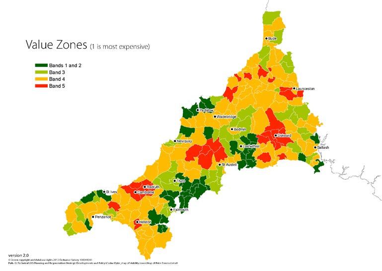
zones are set out in Figure 3.
27You can also read