TRANSPORT, TRAFFIC AND PARKING ASSESSMENT REPORT - APPENDIX P - Sydney Metro
←
→
Page content transcription
If your browser does not render page correctly, please read the page content below
TRANSPORT,
TRAFFIC AND PARKING
 ASSESSMENT REPORT

          APPENDIX P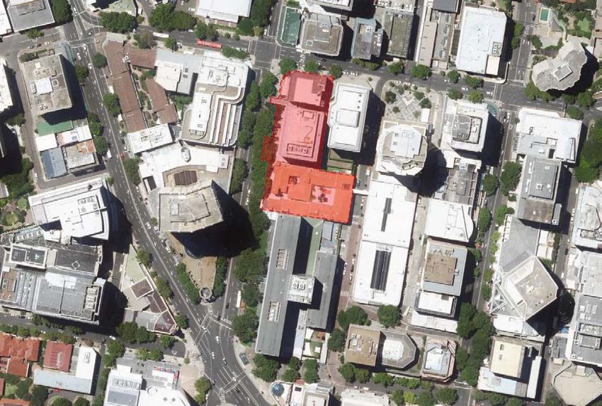
Appendix P

Sydney Metro City & South West
Victoria Cross Over Station
Development:

Traffic and transport report

Applicable to:            Sydney Metro City & Southwest

Author:                   AECOM Australia Pty Ltd

Owner                     Transport for NSW

Status:                   Final

Version:                  7

Date of issue:            17 May 2018

Review date:              17 May 2018

© Sydney Metro 2018
Table of Contents
1.0       Introduction.............................................................................................................5
          1.1         Purpose of this document............................................................................5
          1.2         Overview of the Sydney Metro in its context................................................7
          1.3         Planning relationship between Victoria Cross Station and the OSD ............9
          1.4         Assumptions and limitations ......................................................................11
          1.5         Report structure ........................................................................................11
          1.6         The site .....................................................................................................13
          1.7         Overview of the proposed development ....................................................15
2.0       Scope of assessment ...........................................................................................18
3.0       Regulatory context ...............................................................................................19
          3.1         North Sydney Local Environment Plan 2013 & North Sydney Development
                      Control Plan 2013 .....................................................................................19
          3.2         State Environmental Planning Policy (Infrastructure) 2007 ........................19
          3.3         Greater Sydney Region Plan.....................................................................20
          3.4         North District Plan .....................................................................................20
          3.5         Future Transport Strategy 2056 ................................................................21
          3.6         Sustainable Sydney 2030..........................................................................22
          3.7         Sydney’s Bus Future .................................................................................22
          3.8         Sydney’s Walking Future...........................................................................23
          3.9         Sydney’s Cycling Future............................................................................23
          3.10        Sydney Metro Planning Study – Crows Nest and North Sydney................24
          3.11        Relevant Policies and Guidelines ..............................................................24
4.0       Existing Conditions ..............................................................................................25
          4.1         Existing travel patterns ..............................................................................25
                  4.1.1              Journey to Work (JTW)..............................................................25
                  4.1.2              Household travel survey ............................................................27
                  4.1.3              Trends in Australian transport ...................................................28
          4.2         Road network ............................................................................................29
          4.3         Site vehicular access.................................................................................30
          4.4         Traffic conditions .......................................................................................31
          4.5         Intersection performance...........................................................................32
          4.6         Off Street parking and servicing ................................................................34
          4.7         On-street parking ......................................................................................34

© Sydney Metro 2018                                                                                                     Page 2 of 85

                                              Sydney Metro City & Southwest | Victoria Cross Over Station Development EIS

                                                                                       Appendix P: Traffic and transport report
4.8         Public transport access .............................................................................35
                  4.8.1             Train services............................................................................36
                  4.8.2             Buses ........................................................................................39
                  4.8.3             Taxi ...........................................................................................41
                  4.8.4             Pedestrian access .....................................................................41
          4.9         Cycling network.........................................................................................42
5.0       Servicing and parking provision review..............................................................44
          5.1         Description ................................................................................................44
          5.2         Car parking ...............................................................................................44
          5.3         Bicycle parking ..........................................................................................45
          5.4         Vehicular and bicycle access ....................................................................46
          5.5         Loading dock.............................................................................................49
          5.6         Parking compliance ...................................................................................50
6.0       Transport assessment..........................................................................................51
          6.1         Traffic generation ......................................................................................51
                  6.1.1             Existing traffic generation from passenger vehicles ...................51
                  6.1.2             Existing traffic generation from service vehicles ........................52
                 6.1.3              Summary of existing traffic generation.......................................53
                 6.1.4              Future traffic generation from passenger vehicles .....................54
                 6.1.5              Future traffic generation from service vehicles ..........................54
                 6.1.6              Future traffic generation from Victoria Cross Station .................55
                 6.1.7              Summary of forecast traffic generation ......................................55
          6.2         Transport network impacts ........................................................................56
                 6.2.1              Road network and intersection operation ..................................56
                 6.2.2              Mode share ...............................................................................56
                 6.2.3              Public transport .........................................................................58
                 6.2.4              Cycling ......................................................................................58
                 6.2.5              Emergency vehicle access ........................................................58
          6.3         Pedestrian generation ...............................................................................59
          6.4         Pedestrian impacts....................................................................................59
                 6.4.1              Cumulative impacts ...................................................................59
                 6.4.2              Footpath capacity ......................................................................61

© Sydney Metro 2018                                                                                                     Page 3 of 85

                                              Sydney Metro City & Southwest | Victoria Cross Over Station Development EIS

                                                                                       Appendix P: Traffic and transport report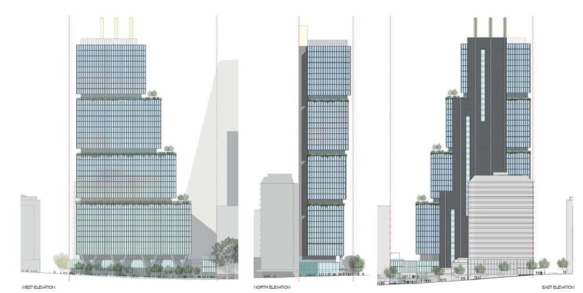
7.0         Cumulative traffic impacts ...................................................................................63
            7.1          Denison street pedestrianisation ...............................................................63
            7.2          Western Harbour Tunnel and Beaches Link ..............................................65
8.0         Construction management methodology ...........................................................69
            8.1          Staging and framework for managing environmental impacts....................69
                     8.1.1             Coordination with other C&SW contracts...................................69
                     8.1.2             OSD construction staging options .............................................69
                     8.1.3             Preferred construction staging scenario ....................................70
                     8.1.4             Management of combined environmental impacts.....................70
            8.2          Construction traffic management principles...............................................71
            8.3          Construction traffic management process .................................................72
            8.4          Construction management statement........................................................73
9.0         Conclusions ..........................................................................................................74
            9.1          Key findings ..............................................................................................74
            9.2          Alignment with SEARs ..............................................................................75
            9.3          Recommendations ....................................................................................80
Appendix A .........................................................................................................................82
            Delivery Service Plan Principles .............................................................................82

© Sydney Metro 2018                                                                                                     Page 4 of 85

                                                 Sydney Metro City & Southwest | Victoria Cross Over Station Development EIS

                                                                                         Appendix P: Traffic and transport report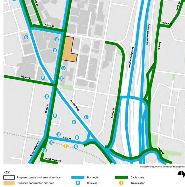
1.0 Introduction
1.1     Purpose of this report
This report supports a concept State Significant Development Application (concept SSD
Application) submitted to the Department of Planning and Environment (DP&E) pursuant to
Part 4 of the Environmental Planning and Assessment Act 1979 (EP&A Act). The concept
SSD Application is made under Section 4.22 of the EP&A Act.
Transport for NSW (TfNSW) is seeking to secure concept approval for a commercial office
tower above the Victoria Cross Station, otherwise known as the over station development
(OSD). The concept SSD Application seeks consent for a building envelope and its use as a
commercial premises (office, business and retail), maximum building height, maximum gross
floor area, pedestrian and vehicular access, circulation arrangements and associated car
parking, future subdivision (if required) and the strategies and design parameters for the
future detailed design of development.
TfNSW proposes to procure the construction of the OSD as part of an Integrated Station
Development package, which would result in the combined delivery of the station, OSD and
public domain improvements. The station and public domain elements form part of a
separate planning approval for Critical State Significant Infrastructure (CSSI) approved by
DP&E on 9 January 2017.

The project is identified as State Significant Development pursuant to Schedule 1, 19(2) (a)
of the State Significant Development (SSD) pursuant to Schedule 1, 19(2) (a) of the State
Environmental Planning Policy (State and Regional Development) 2011 (SRD SEPP). This
relates to the project’s attributes, which include its proximity to the rail corridor, and its
inclusion of railway infrastructure and commercial premises with a Capital Investment Value
of more than $30 million.
This report has been prepared to specifically respond to the Secretary’s Environmental
Assessment Requirements (SEARs) issued for the concept SSD Application for Victoria
Cross OSD. The SEARs were issued on 30th November 2017 and require that the EIS
include a Transport and Traffic Impact Assessment that provides, but is not limited to, the
following:

        Accurate details of the current daily and peak hour vehicle, public transport,
        pedestrian and bicycle movements from existing buildings/ uses on the site using the
        adjacent and surrounding road network;
        Forecast total daily and peak hour trips likely to be generated by the proposed
        development including vehicle, public transport, pedestrian and bicycle trips, together
        with cumulative impacts of existing, proposed and approved developments in the
        area and any transport/traffic upgrade;

© Sydney Metro 2018                                                                               Page 5 of 85

                                   Sydney Metro City & Southwest | Victoria Cross Over Station Development EIS

                                                                      Appendix P: Traffic and transport report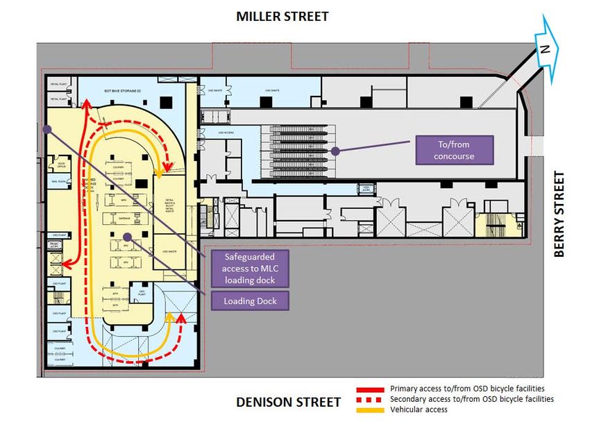
Impacts of the proposed development on the operation of existing and future
        transport networks, including the public transport capacity and its ability to
        accommodate the forecast number of trips to and from the development;
        Detailed assessment of the existing and future performance of key intersections
        providing access to the site, supported by appropriate modelling and analysis to the
        satisfaction of RMS and TfNSW;
        Measures to mitigate impacts of the proposed development on the operation of
        existing and future traffic, public transport, pedestrian and bicycle networks, including
        any required upgrades;
        Proposed car and bicycle parking provision for workers and visitors, including
        consideration of the availability of public transport and the requirements of the
        relevant parking codes and Australian Standards;
        Loading dock and servicing arrangements, including consideration of loading zone
        hub facilities;
        Measures to be implemented to encourage users of the development to make
        sustainable travel choices, including walking, cycling, public transport and car
        sharing, such as provision of adequate bicycle parking and end of trip facilities;
        Consider the future pedestrianisation of laneways east of the Metro site (Denison
        Street, Spring Street and Little Spring Street) with regard to the North Sydney
        Council concept plan for the treatment of laneways in the CBD;
        Consider the impacts of the proposed Western Harbour Tunnel Beaches Link; and
        Identify required work zones and the functionality and impact on pedestrian amenity
        and public domain.

© Sydney Metro 2018                                                                               Page 6 of 85

                                   Sydney Metro City & Southwest | Victoria Cross Over Station Development EIS

                                                                      Appendix P: Traffic and transport report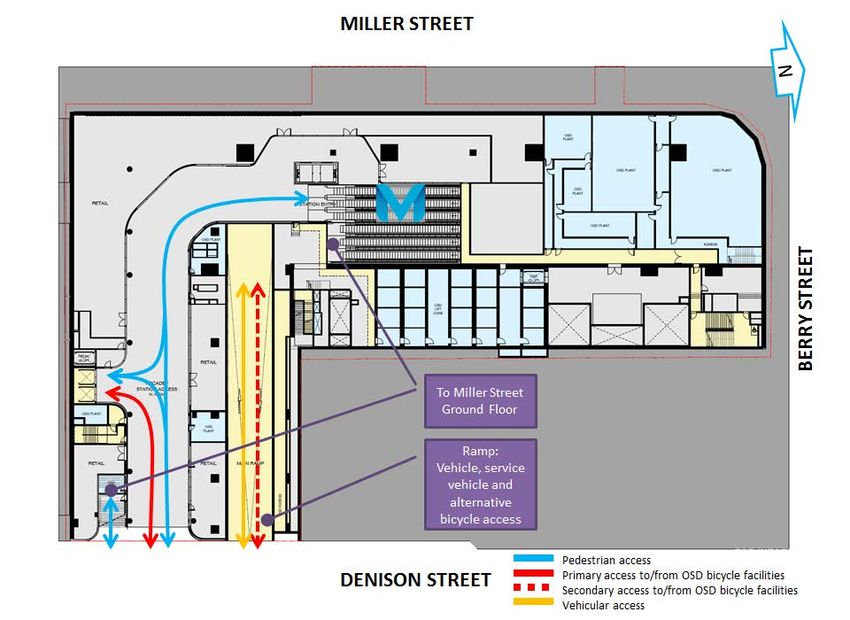
1.2      Overview of the Sydney Metro in its context
The New South Wales (NSW) Government is implementing Sydney’s Rail Future, a plan to
transform and modernise Sydney’s rail network so that it can grow with the city’s population
and meet the needs of customers in the future (Transport for NSW, 2012). Sydney Metro is a
new standalone rail network identified in Sydney’s Rail Future.

Sydney Metro is Australia’s biggest public transport project, consisting of Sydney Metro
Northwest (Stage 1), which is due for completion in 2019 and Sydney Metro City &
Southwest (Stage 2), which is due for completion in 2024 (Refer to Figure 1).

Figure 1: Sydney Metro alignment map

Stage 2 of Sydney Metro includes the construction and operation of a new metro rail line
from Chatswood, under Sydney Harbour through Sydney’s CBD to Sydenham and on to
Bankstown through the conversion of the existing line to metro standards.

The project also involves the delivery of seven (7) new metro stations, including at North
Sydney. Once completed, Sydney Metro will have the ultimate capacity for 30 trains an hour
(one every two minutes) through the CBD in each direction - a level of service never seen
before in Sydney.

© Sydney Metro 2018                                                                                   Page 7 of 85

                                       Sydney Metro City & Southwest | Victoria Cross Over Station Development EIS

                                                                          Appendix P: Traffic and transport report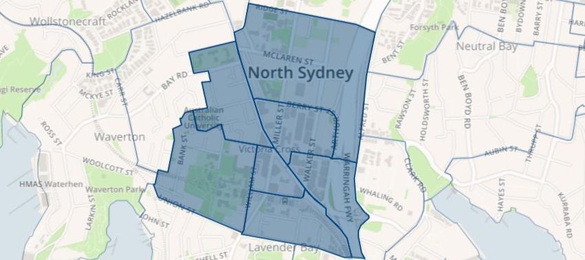
On 9 January 2017, the Minister for Planning approved the Sydney Metro City & Southwest -
Chatswood to Sydenham application lodged by TfNSW as a Critical State Significant
Infrastructure project (reference SSI 15_7400), hereafter referred to as the CSSI Approval.
The CSSI Approval includes all physical work required to construct the CSSI, including the
demolition of existing buildings and structures on each site. Importantly, the CSSI Approval
also includes provision for the construction of below and above ground structures and other
components of the future OSD (including building infrastructure and space for future lift
cores, plant rooms, access, parking and building services, as relevant to each site). The
rationale for this delivery approach, as identified within the CSSI application is to enable the
OSD to be more efficiently built and appropriately integrated into the metro station structure.
The EIS for the Chatswood to Sydenham component of the City & Southwest project
identified that the OSD would be subject to a separate assessment process.
Since the CSSI Approval was issued, Sydney Metro has lodged four modification
applications to amend the CSSI Approval as outlined below:
        Modification 1- Victoria Cross and Artarmon Substation which involves relocation of
        the Victoria Cross northern services building from 194-196A Miller Street to 50
        McLaren Street together with inclusion of a new station entrance at this location
        referred to as Victoria Cross North. 52 McLaren Street would also be used to
        support construction of these works. The modification also involves the relocation of
        the substation at Artarmon from Butchers Lane to 98 – 104 Reserve Road. This
        modification application was approved on 18 October 2017.
        Modification 2- Central Walk which involves additional works at Central Railway
        Station including construction of a new eastern concourse, a new eastern entry, and
        upgrades to suburban platforms. This modification application was approved on 21
        December 2017.
        Modification 3 - Martin Place Station which involves changes to the Sydney Metro
        Martin Place Station to align with the Unsolicited Proposal by Macquarie Group
        Limited (Macquarie) for the development of the station precinct. The proposed
        modification involves a larger reconfigured station layout, provision of a new unpaid
        concourse link and retention of the existing MLC pedestrian link and works to
        connect into the Sydney Metro Martin Place Station. It is noted that if the Macquarie
        proposal does not proceed, the original station design remains approved. This
        modification application was approved on 22 March 2018.
        Modification 4 - Sydenham Station and Sydney Metro Trains Facility South which
        incorporates Sydenham Station and precinct works, the Sydney Metro Trains Facility
        South, works to Sydney Water’s Sydenham Pit and Drainage Pumping Station and
        ancillary infrastructure and track and signalling works into the approved project. This
        modification application was approved on 13 December 2017.

© Sydney Metro 2018                                                                               Page 8 of 85

                                   Sydney Metro City & Southwest | Victoria Cross Over Station Development EIS

                                                                      Appendix P: Traffic and transport report
Given the modifications, the CSSI Approval is now approved to operate to Sydenham
Station and also includes the upgrade of Sydenham Station.
The remainder of Stage 2 of the City & Southwest project (Sydenham to Bankstown)
proposes the conversion of the existing heavy rail line and the upgrade of the existing
railway stations along this alignment to metro standards. This part of the project, referred to
as the Sydenham to Bankstown Upgrade, is the subject of a separate CSSI Application
(Application No. SSI 17_8256) which is currently being assessed by the DP&E.
1.3 Planning relationship between Victoria Cross station and the
OSD
While the Victoria Cross station and OSD will form an Integrated Station Development, the
planning pathways defined under the Environmental Planning & Assessment Act 1979
require separate approval for each component of the development. In this regard, the
approved station works (CSSI Approval) are subject to the provisions of Part 5.1 of the
EP&A Act (now referred to as Division 5.2) and the OSD component is subject to the
provisions of Part 4 of the EP&A Act.
For clarity, the approved station works under the CSSI Approval include the construction of
below and above ground structures necessary for delivering the station and also enabling
construction of the integrated OSD. This includes but is not limited to:
Demolition of existing development
Excavation
Station structure including concourse and platforms
Lobbies
Retail spaces within the station building
Public domain improvements
Pedestrian through-site link
Access arrangements including vertical transport such as escalators and lifts
Structural and service elements and the relevant space provisioning necessary for
constructing OSD, such as columns and beams, space for lift cores, plant rooms,
access, parking, retail and building services.
The vertical extent of the approved station works above ground level is defined by the
‘transfer slab’ level (which for Victoria Cross is defined by RL 82), above which would sit the
OSD. This delineation is illustrated in Figure 2.
© Sydney Metro 2018 Page 9 of 85
Sydney Metro City & Southwest | Victoria Cross Over Station Development EIS
Appendix P: Traffic and transport reportFigure 2: Delineation between Metro station and OSD
The CSSI Approval also establishes the general concept for the ground plane of Victoria
Cross Station including access strategies for commuters, pedestrians and workers. In this
regard, pedestrian access to the station would be from Miller and Denison Streets and the
commercial lobby would be accessed from Miller Street. Retail uses (approved under the
CSSI Approval) would be located on the ground floor of the development at both the Miller
Street and Denison Street levels activating the through-site link. Separate consent would be
sought in the future for the fit-out and specific use of this retail space.
Since the issue of the CSSI Approval, TfNSW has undertaken sufficient design work to
determine the space planning and general layout for the station and identification of those
spaces within the station area that would be available for the OSD. In addition, design work
has been undertaken to determine the technical requirements for the structural integration of
the OSD with the station. This level of design work has informed the concept proposal for
the OSD. It is noted that ongoing design development of the works to be delivered under the
CSSI Approval would continue with a view to developing an Interchange Access Plan (IAP)
and Station Design Precinct Plan (SDPP) for Victoria Cross Station to satisfy Conditions E92
and E101 of the CSSI Approval.
The public domain improvement works around the site would be delivered as part of the
CSSI Approval.
© Sydney Metro 2018 Page 10 of 85
Sydney Metro City & Southwest | Victoria Cross Over Station Development EIS
Appendix P: Traffic and transport report1.4 Assumptions and limitations
The assessment is based on the following assumptions and limitations:
The traffic generation rates as stated in the RMS Guide to Traffic Generating
Developments (2002) and the more recent RMS Technical Direction 2013/04a: Guide
to Traffic Generating Developments – Updated Traffic Surveys (RMS, 2013) and are
generally conservative given the characteristics of the planned uses.
Traffic distribution is based on information extracted from BTS Journey to Work data
for the North Sydney area.
The network assessment is limited to Weekday AM and PM peak period site survey
information obtained for local intersections in proximity of the site and RMS SCATS
data provided by RMS.
The land uses are consistent with the detail provided in the concept plan SSD
Application for the Victoria Cross and include consideration of the land uses in the
CSSI Approval (including station retail).
The assessment is based on an existing situation and full development of the site as
an Integrated Station Development and is limited by the data obtained and identified
in this report.
The assessment of the site and concept proposal does not consider development
staging as these are unlikely to impact on the local road network above or beyond
the current station construction activity. The possible construction staging scenarios
are addressed in Section 8.
The impact from the proposed construction activity on surrounding development is
expected to be managed through the staging of the development as stated in section
8.
The assessment was carried out at a high level using SIDRA modelling software and
does not consider detailed operational aspects related to specific uses beyond the
operation of local intersections during weekday AM and PM peak periods.
1.5 Report structure
The report is structured as follows:
This section – introduces the project, its relationship with Sydney Metro and
previous planning approvals, the SEARs for this proposal, the purpose and
limitations of the report, an overview of the site and its proximity within North Sydney
CBD, and an overview of the proposed development and its key features
Section 2.0 – covers the scope of the assessment
Section 3.0 – covers relevant legislation, policies and guidelines and its association
with the traffic and transport elements of this application
© Sydney Metro 2018 Page 11 of 85
Sydney Metro City & Southwest | Victoria Cross Over Station Development EIS
Appendix P: Traffic and transport reportSection 4.0 – provides an understanding of the existing situation including area and
network characteristics and the service and facility conditions.
Section 5.0 – defines the transport, traffic, parking and access attributes of the
proposal that form the basis for the assessment in section 6.
Section 0 – assesses the transport, traffic, parking, servicing and access impacts
from the likely operations of the proposed OSD Concept Design
Section 7.0 –provides an understanding of the key cumulative impacts and the
proposals relationship with known surrounding schemes
Section 8.0 – summarises the proposal options for managing the construction of the
OSD Concept and highlights the construction management principles that are
recommended to be adopted.
Section 9.0 –summarises how the Transport and Traffic elements of the SEARs
have been addressed, the key findings and recommended mitigation measures for
future stages in the planning process.
© Sydney Metro 2018 Page 12 of 85
Sydney Metro City & Southwest | Victoria Cross Over Station Development EIS
Appendix P: Traffic and transport report1.6 The site
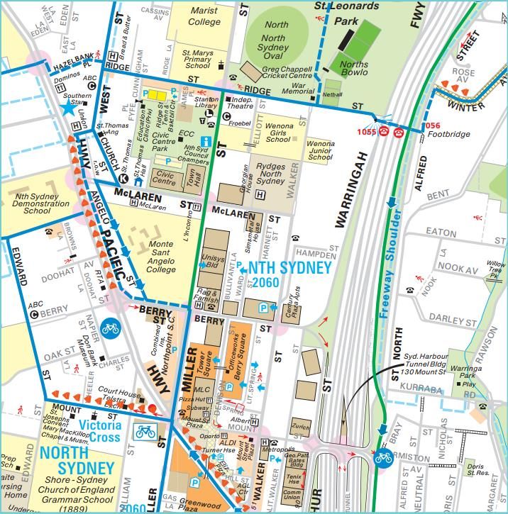
The Victoria Cross OSD site is located at the southeast corner of the intersection of Miller
and Berry Streets, North Sydney, above the southern portal of the future Victoria Cross
Station (refer Figure 3). The site is located in North Sydney CBD, which is identified as part
of Sydney’s “Harbour CBD” (along with Sydney CBD) in the Greater Sydney Region Plan
(2018). It is the third largest office market in Sydney and is a key component of Sydney’s
Global Economic Corridor.
Figure 3: Victoria Cross Station location plan
The proposed Victoria Cross Station is expected to perform as a key destination station
along the future Sydney Metro network through is ability to serve on a growing North Sydney
Central Business District (CBD). The proposal forms part of an integration development and
aligns with:
transit orientated development concept (identified in this report as an integrated
station design); and
the vision and direction set within Future Transport for the Eastern Harbour City
concept through its proximity to the public transport network, utilisation of existing
and planned infrastructure and assets, its contribution to the North Sydney skyline
and its ability to deliver on a 30 minute city.
© Sydney Metro 2018 Page 13 of 85
Sydney Metro City & Southwest | Victoria Cross Over Station Development EIS
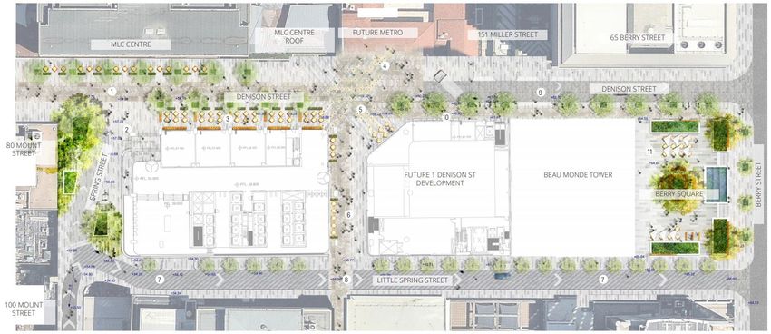
Appendix P: Traffic and transport reportThe southern portal site for Victoria Cross (refer Figure 4) is irregular in shape, has a total
area of approximately 4,815 square metres and has street frontages of approximately 37
metres to Berry Street, 34 metres to Denison Street and 102 metres to Miller Street.
Figure 4: The Site
The site is located in North Sydney Centre in the North Sydney Local Government Area and
forms part of the central core of the Eastern Harbour City. It is planned to be positioned
above the proposed Sydney Metro Victoria Cross Station and within the existing North
Sydney CBD. This enables the site to offer users facilities and services within easy walking
distance together with fast frequent high quality transport connections to other key urban
centres that are identified to support future growth. These include:
Sydney CBD approximately 3km to the south.
Chatswood approximately 5km to the northwest.
St Leonards / Crows Nest approximately 2km to the northeast.
The site comprises the following properties:
155–167 Miller Street SP 35644 (formerly Tower Square)
181 Miller Street Lot 15 in DP 69345, Lot 1 & Lot 2 DP 123056
and Lot 10 in DP 70667
187 Miller Street Lot A in DP 160018
© Sydney Metro 2018 Page 14 of 85
Sydney Metro City & Southwest | Victoria Cross Over Station Development EIS
Appendix P: Traffic and transport report189 Miller Street Lot 1 in DP 633088
Formerly part 65 Berry Street Lot 1 in DP 1230458
1.7 Overview of the proposed development
This concept SSD Application comprises the first stage of the Victoria Cross OSD project. It
will be followed by a detailed SSD Application for the design and construction of the OSD to
be lodged by the successful contractor who is awarded the contract to deliver the Integrated
Station Development.
This concept SSD Application seeks approval for the planning and development framework
and strategies to inform the future detailed design of the OSD. It specifically seeks approval
for the following:
A building envelope as illustrated in Figure 5
A maximum building height of RL 230 or 168 metres (approximately 42 storeys,
compromising of 40 commercial storeys and 2 additional storeys for the roof top
plant) for the high rise portion of building envelope and RL 118 or 55 metres
(approximately 13 storeys) for the high rise portion of building envelope and RL 118
or 55 metres (approximately 13 storeys) for the lower rise eastern portion of the
building envelope
A maximum gross floor area (GFA) of 60,000 square metres for the OSD component,
which is equivalent to a floor space ratio of 12.46:1
Use of the building envelope area for commercial premises including commercial
office, retail and business premises
Use of the conceptual OSD space provisioning within the footprint of the CSSI
Approval (both above and below ground), including the OSD lobby and associated
retail space, basement parking, end-of-trip facilities, services and back-of-house
facilities
Car parking for a maximum of 150 parking spaces over four basement levels with an
additional 11 parking spaces allocated to the station retail approved under the terms
of the CSSI Approval
Loading, vehicle and pedestrian access arrangements from Denison Street
Strategies for utility and services provision
Strategies for the management of stormwater and drainage
A strategy for the achievement of ecologically sustainable development
Indicative signage zones
A strategy for public art
A design excellence framework
The future subdivision of parts of the OSD footprint (if required).
© Sydney Metro 2018 Page 15 of 85
Sydney Metro City & Southwest | Victoria Cross Over Station Development EIS
Appendix P: Traffic and transport reportThe total GFA for the Integrated Station Development including the station GFA (i.e. retail,
station circulation and associated facilities) and the OSD GFA is 67,000 square metres and is
equivalent to a FSR of 13.9:1.
A drawing illustrating the proposed building envelope is provided in Figure 5.The concept SSD
Application includes an indicative design for the OSD to demonstrate one potential design
solution within the proposed building envelope (refer to Figure 6).
Victoria Cross Station is to be a key station on the future Sydney Metro network, providing
access to the growing North Sydney Central Business District (CBD). The proposal
combines the Metro station with a significant commercial office tower, contributing to the
North Sydney skyline. The OSD would assist in strengthening the role of North Sydney as a
key component of Sydney’s global economic arc and would contribute to the diversity,
amenity and commercial sustainability of the CBD.
It is noted that Victoria Cross northern services building and new station entrance at Victoria
Cross North do not form part of the concept SSD Application.
Figure 5: Proposed Victoria Cross OSD building envelope
Source: Bates Smart
© Sydney Metro 2018 Page 16 of 85
Sydney Metro City & Southwest | Victoria Cross Over Station Development EIS
Appendix P: Traffic and transport reportFigure 6: Victoria Cross Indicative OSD Design
Source: Bates Smart
© Sydney Metro 2018 Page 17 of 85
Sydney Metro City & Southwest | Victoria Cross Over Station Development EIS
Appendix P: Traffic and transport report2.0 Scope of assessment
This report is based on the OSD concept design drawings provided by TfNSW (thereafter
referred to as the indicative OSD design). This report documents the traffic and transport
impact assessment that has been undertaken for the OSD. It discusses the forecast impacts
on the surrounding road/pedestrian network from the proposed development and its
traffic/pedestrian generation, parking (vehicle and bicycle) and servicing requirements, and
also the cumulative impact of a number of proposed projects likely to impact surrounding
network operations in the future.
Owing to the OSD’s location above the CSSI approved Victoria Cross Station, a series of
collaboration workshops have been undertaken with TfNSW’s Stage 1 design Team
(METRON) to coordinate the designs, identify challenges and propose solutions. This
occurred as METRON advanced towards their Stage 1 design deliverable (approximately a
40% level of definition).
The assessment includes the traffic and transport assessment required to service the retail
tenancies and the commercial floor space in the Indicative OSD design.
The assessment incorporated:
Review of relevant legislation, policies and guidelines associated with traffic and
transport;
Consultation with TfNSW regarding traffic and pedestrian modelling, parking and
servicing requirements for the station;
Assessment of the forecast traffic and pedestrian impacts resulting from the operation of
the proposed Indicative OSD design and retail concessions associated with the station;
and
Assessment of the car parking, access and service dock design layout illustrated in the
Indicative OSD design.
© Sydney Metro 2018 Page 18 of 85
Sydney Metro City & Southwest | Victoria Cross Over Station Development EIS
Appendix P: Traffic and transport report3.0 Regulatory context
The following documents provide a number of transport planning provisions, goals and
strategic planning objectives which are relevant to the proposal.
3.1 North Sydney Local Environment Plan 2013 & North Sydney
Development Control Plan 2013
The North Sydney Local Environment Plan (LEP) 2013 is the principal legal document for
controlling development and guiding planning decisions within the North Sydney Council
area. The North Sydney Development Control Plan 2013 (DCP) provides guidance which
supports the implementation of the LEP. Although the DCP is not applicable to the SSD, it
provides a guide to the maximum number of on-site car parking spaces that can be provided
for new developments based on their location and level of transport accessibility. It also
recommends the minimum number of bicycle parking spaces to be provided by new
developments.
3.2 State Environmental Planning Policy (Infrastructure) 2007
The aim of the Infrastructure SEPP is to facilitate the provision of infrastructure across NSW.
Clauses relevant to the development include:
Clause 88B: Development near proposed metro stations
A consent authority must not grant consent to development on land to which this clause
applies unless it has taken into consideration:
- Whether the proposed development will adversely affect the development and
operation of a proposed metro station, including by impeding access to, or egress
from, the proposed metro station; and
- Whether the proposed development will encourage the increased use of public
transport.
The proposed development is to be constructed above the entrance to Victoria Cross
Station, and will not adversely affect access / egress to the proposed Sydney Metro Station.
Furthermore, the station is likely to encourage and facilitate the increased use of public
transport to and from the development.
Clause 104: Traffic-generating development
This clause sets out thresholds for scale of new or extended development, above which the
consenting authority must:
© Sydney Metro 2018 Page 19 of 85
Sydney Metro City & Southwest | Victoria Cross Over Station Development EIS
Appendix P: Traffic and transport reporta) Give written notice of the application to Roads and Maritime Services (Roads and
Maritime) within 7 days after the application is made, and
b) Take into consideration:
i. Any submission that RMS provides in response to that notice within 21 days after
the notice was given (unless, before the 21 days have passed, RMS advises that
it will not be making a submission), and
ii. The accessibility of the site concerned, including:
- The efficiency of movement of people and freight to and from the site and the
extent of multi-purpose trips, and
- The potential to minimise the need for travel by car and to maximise
movement of freight in containers or bulk freight by rail, and
iii. Any potential traffic safety, road congestion or parking implications of the
development.
The consent authority must follow these steps when assessing the development application
submitted for this development.
This traffic impact assessment has been prepared to assess how the proposed OSD impacts
these criteria, and where necessary describe possible mitigation measures to ensure the
efficiency of movement, reduce the need for private car travel and address any traffic safety,
congestion and parking impacts.
3.3 Greater Sydney Region Plan
In March 2018 A Metropolis of Three Cities – the Greater Sydney Region Plan was released.
The plan, along with Transport for NSW’s Future Transport 2056 and Infrastructure NSW’s
State Infrastructure Strategy 2018-36 will bring to life the vision of Greater Sydney as a
vibrant and sustainable metropolis of the Eastern Harbour City, Central River City and
Western Parkland City. It provides strategic direction for Sydney’s productivity,
environmental management, and liveability; and for the location of housing, employment,
infrastructure and open space. The Plan’s vision is to maintain Sydney’s position as a strong
global city and a great place to live. The proposed development is part of the Victoria Cross
Station that will contribute to the implementation of a world class transport system that is
connected, accessible and can accommodate the future demands of a growing population.
3.4 North District Plan
The Greater Sydney Regional Plan nominates six districts of Sydney, the district plans have
been released by the Greater Sydney Commission (GSC).
© Sydney Metro 2018 Page 20 of 85
Sydney Metro City & Southwest | Victoria Cross Over Station Development EIS
Appendix P: Traffic and transport reportThe North District Plan (GSC, 2018) sets out priorities and actions for the North District,
where the proposal is located. The vision includes strengthening the transport connections
from North Sydney CBD to the Eastern Economic Corridor and the Harbour CBD and is
illustrated in Figure 7.
Figure 7: North District Plan
Source: Greater Sydney Commission, 2018
The introduction of the new Victoria Cross Station will help strengthen the transport
connection from North Sydney CBD to the Eastern Economic Corridor and the Harbour CBD
through more frequent and better connected rail services. The proposed OSD will provide a
significant level of employment. Being located above the Victoria Cross Station, it will help
expand the catchment of accessibility through non-car modes of travel by taking advantage
of this important transport connection.
3.5 Future Transport Strategy 2056
The Future Transport Strategy 2056 is NSW Government’s framework for planning and
improving NSW transport system and was developed as part of the 5-year update to the
2012 Long Term Transport Master Plan for NSW. The plan enables Sydney to prepare for a
period of population growth with a vision for setting a pathway up to 2056. This vision is
based on Greater Sydney being a metropolis of three cities (Eastern Harbour City, Central
River City and Western Parkland City).
© Sydney Metro 2018 Page 21 of 85
Sydney Metro City & Southwest | Victoria Cross Over Station Development EIS
Appendix P: Traffic and transport reportThe strategy to accommodate population growth seeks to take advantage of technological
enabled mobility that offers opportunities to maximise travel by car free alternatives within
Sydney. This includes the transformation of the mass transit network to align with a 30
minute trip to services and employment. It also recognises the role of automation and how it
can help to improve safety, travel choices and mode concepts, service frequency, reliability
and travel times for customers when travelling within and around Sydney’s transport
network.
Sydney Metro City and Southwest and the proposed Victoria Cross station form a key part of
this future vision. It offers a modern technologically advanced public transport system
solution, which through the provision of a strategic public transport hub, supports both place
making and efficient connections to and from the North Sydney CBD. Future activity
generated by the proposed OSD (this application) will directly benefits from Sydney Metro,
which will help to appropriate manage its impacts through its proximity within North Sydney
CBD and its alignment with the objectives of this strategy.
3.6 Sustainable Sydney 2030
The plan for Sydney moving forward is to become a green city, whilst delivering world class
services and competing economically on a global scale. Sustainable transport networks are
key for Sydney to achieve this, and the Sydney Metro and proposed OSD will help contribute
to creating a more sustainable and active transport system within the CBD and inner city
suburbs.
3.7 Sydney’s Bus Future
Sydney’s Bus Future (Transport for NSW, 2013) provides the framework for improving and
delivering more frequent and reliable bus services throughout Sydney. The core aim of the
strategy is to provide an integrated bus network with seamless connections to other
transport services.
The strategy also aims to tailor bus services to customer needs. In this vein, bus services
will be focused into three key types, with associated priority and infrastructure investment:
- Rapid routes, which will use priority infrastructure, connect regionally throughout the
city and have stops every 800m-1km
- Suburban routes, which will have stops every 400m and have mix of frequent ‘turn
up and go’ and timetabled services
- Local routes, which will complete the network using local streets.
For North Sydney, the plan proposed that Local services will continue to run as peak
expresses for commuters to the CBD, providing fast, reliable and convenient access from
© Sydney Metro 2018 Page 22 of 85
Sydney Metro City & Southwest | Victoria Cross Over Station Development EIS
Appendix P: Traffic and transport reportinner Sydney suburbs such as North Sydney, Five Dock and Bondi Beach, supported by
new bus priority.
3.8 Sydney’s Walking Future
Sydney’s Walking Future (Transport for NSW, 2013) sets out a strategy to encourage people
in Sydney to walk more through actions that make it a more convenient, better connected
and safer mode of transport.
Key points to emerge from the strategy that are relevant to the proposed development
include:
- NSW Government commitment to invest in new walking links that connect people to
public transport.
- Prioritisation of investment in walking infrastructure to be prioritised within 2km of
centres and public transport interchanges.
- Commitment to invest in walking facilities as part of the Transport Access Program,
including improved circulation spaces around station precincts and safer walking
links.
The highest number of walking trips per day are made by people who live in Sydney (3.4
trips), Leichhardt (2.9 trips) and North Sydney (2.8 trips), with walking to work taking place
more often around major centres. With the third highest number of walking trips per day
taking place in North Sydney, and with the introduction of a metro station, the development
is well placed to take advantage of this strategy to encourage walking trips to and from the
site.
3.9 Sydney’s Cycling Future
Sydney’s Cycling Future (Transport for NSW, 2013) provides a framework for the way
cycling is planned and prioritised in Sydney. It aims to grow the number of people cycling for
transport by investing in safe, connected networks, making better use of existing
infrastructure and fostering the formation of partnerships to develop cycling infrastructure.
Key points to emerge from the strategy that are relevant to the OSD include:
- A safe and connected bicycle network benefits the wider transport network by
improving access to towns and centres, reducing congestion and increasing
capacity on the public transport system.
- The promotion of safe separation of cyclists from motor vehicles and pedestrians
where possible.
- Investment in bicycle infrastructure should be prioritised within 5km of public
transport interchanges to provide improved connections.
© Sydney Metro 2018 Page 23 of 85
Sydney Metro City & Southwest | Victoria Cross Over Station Development EIS
Appendix P: Traffic and transport report- Promoting ‘bike-and-ride’ at major public transport interchanges including secure
parking facilities integrated with public transport access.
The North Sydney Council is moving towards a well-connected cycle network to improve
accessibility for workers and visitors to the CBD. The development would encourage people
to cycle by providing high quality end-of-trip facilities for employees and visitors.
3.10 Sydney Metro Planning Study – Crows Nest and North Sydney
In response to the introduction of Sydney Metro, North Sydney Council has prepared a
planning study which aims to inform and guide the future planning and development of the
Metro, including OSD on Metro sites and their immediate surroundings.
The study concludes that OSD on metro sites will contribute to the overall amenity of the
North Sydney Centre, particularly with regard to provision of new commercial floor space in
the North Sydney Centre commercial core and the creation of new public spaces facilitating
a sense of place and identity. The implementation of OSD allows the incorporation of design
excellence to create an exceptional built form, and improve the performance and capacity of
the public domain in the vicinity of the site.
3.11 Relevant Policies and Guidelines
The following documents have also been considered in the development of this report:
Roads and Maritime Services Guide to Traffic Generating Developments.
Australian Standard - AS2890 Parking Facilities Parts 1 - 6
North Sydney Council Development Control Plan (DCP) 2013
North Sydney Council’s Central Laneways Masterplan proposals exhibited during
January 2018
© Sydney Metro 2018 Page 24 of 85
Sydney Metro City & Southwest | Victoria Cross Over Station Development EIS
Appendix P: Traffic and transport report4.0 Existing Conditions
4.1 Existing travel patterns
Travel data obtained from the Australian Bureau of Statistics (ABS) provides an insight into
the Journey to Work (JTW) and household Travel Survey (HTS) characteristics of workers
and residents of North Sydney respectively. This data is based off the 2011 Census data
collected by the ABS.
The Bureau of Transport Statistics (BTS) derives the ABS data collected during the 2011
Census, which includes method of travel to work at a travel zone level. Travel zones 1951,
1952, 1953, 1954, 1955, 1956 and 1957 represent the immediate catchment area of Victoria
Cross Station which is illustrated in Figure 8.
Figure 8: Location of Travel Zones 1951, 1952, 1953, 1954, 1955, 1956 and 1957
Source – NSW Bureau of Transport Statistics, 2017
4.1.1 Journey to Work (JTW)
Table 1 presents the following travel characteristics for the 39,511 people who work in these
travel zones and indicates:
The current high proportion of journey to work trips that are made by train, which
highlights that approximately 47 per cent of trips are attributable to this mode.
A total public transport mode share of 59 per cent, which is significantly greater than the
Greater Sydney average of 20 per cent and similar to other highly accessible Eastern
Harbour City localities.
© Sydney Metro 2018 Page 25 of 85
Sydney Metro City & Southwest | Victoria Cross Over Station Development EIS
Appendix P: Traffic and transport reportA high proportion of private vehicle trips for a CBD location, which currently represents
31 per cent of trips to the area.
These statistics reflect the area’s characteristics and are influenced by high public transport
service levels, good levels of connectivity to surrounding catchments, local and surrounding
density levels and its proximity to North Sydney and public transport catchments and parking
provision and management of long-term parking demand in the CBD.
In additional to the data for North Sydney the analysis also benchmarks against other highly
accessible locations situated in the Eastern Harbour City that is influenced by parking
controls, congestion along the road network, high density mix used environments and high
public transport accessibility and service levels. This information is presented in Table 1 for
travel zones that represent the Pitt Street and Martin Place catchment areas. The ABS data
indicates that Pitt Street and Martin Place display mode share travel trends that generate 7-9
per cent higher trips by public transport and approximately 17 per cent lower car trips.
Table 1: Journey to work mode share for workers near Victoria Cross Station
Source: BTS, based on 2011 Census
Eastern Harbour City
Greater Sydney
Mode of travel North Sydney Pitt Street Martin Place
Train 17,157 (47%) 47% 42% 14%
Bus 4,250 (12%) 21% 22% 6%
Car (driver) 10,376 (28%) 67%
14% 15%
Car (passenger) 1,130 (3%) 5%
Walked only 2,283 (6%) 6% 6% 4%
Mode not stated 424 (1%) 2%
11% 11%
Other (including bicycle) 1,039 (3%) 2%
Note: Excludes those who did not go to work
The construction and opening of the Sydney Metro City and Southwest (C&SW) line
(including Victoria Cross Station), together with the further intensification of North Sydney
CBD and the planned intensification of centres situated along the Sydney Metro C&SW
project alignment, may support a mode share comparable to Pitt Street or Martin Place. This
would see a reduction in the proportion of private vehicle generated trips and an increase in
the public / active transport mode share for North Sydney in the future.
© Sydney Metro 2018 Page 26 of 85
Sydney Metro City & Southwest | Victoria Cross Over Station Development EIS
Appendix P: Traffic and transport report4.1.2 Household travel survey
The Household Travel Survey highlights travel trends for residents of the catchment, which
is based on a survey of 2,179 people. Figure 9 illustrates the data set and indicates a high
public transport (trains and buses) mode share at 43 per cent with private vehicle
representing 29 per cent of all trips. Due to the proximity of the residential area to services
and employment the walk only mode is higher at 24 per cent and will be further influenced by
the continued intensification of North Sydney CBD and Crows Nest and St Leonards
precincts.
Figure 9: North Sydney residents’ mode choice split
Source – NSW Transport Performance and Analytics, 2011
In addition to the above, the latest journey to work data generated from the 2016 Census
data for centrally based local areas in City of Sydney and North Sydney LGA was also
reviewed (source - https://profile.id.com.au).
The review highlighted that the origin and destination of trips and the quality of travel choices
by mode influences how people travel. The data reviewed as part of this assessment
highlights that travel mode choice is influenced by proximity to transit options and the quality
of its offering together with controls on parking. The data also highlights that North Sydney
has a relationship with Sydney inner city (37% of trips), North Sydney/Mosman (33% of
trips), Chatswood/Lane Cove (10% of trips), and Ryde/Hunters Hill (4% of trips), which in
total represent 84% of trips generated into North Sydney. All of the above origins appear to
offer train, bus and active transport options for access to North Sydney.
Another trend that was identified from the review of data was that whilst the public transport
mode share and proportion of people living and working in the LGA was similar, the
difference was a lower dependency on private vehicle for access in the City of Sydney and a
higher dependency on walking and cycling. The review of the 2011 census data against the
2016 census data highlighted that the proportion of trips made by private vehicle trips in both
North Sydney and the City of Sydney is reducing and travel by rail, and in most cases,
walking is increasing in total and as a proportion of total journey to work trips.
© Sydney Metro 2018 Page 27 of 85
Sydney Metro City & Southwest | Victoria Cross Over Station Development EIS
Appendix P: Traffic and transport reportThis general trend was plotted for land use and highlights a high public transport mode share
around existing rail station nodes, as illustrated in Figure 10. It is also noted that the area
that will accommodate both the Victoria Cross Station and OSD already presents a trend for
high public transport travel for journey to work purposes.
Figure 10: Households travel to work by public transport
Source: Social Atlas North Sydney Council, 2017
4.1.3 Trends in Australian transport
Charting Transport is a website that reviews transport data and the trends of how people
travel in Australian cities. This includes research on growth in car travel plotted against
population growth and mass transit passenger kilometres travelled in Australia’s five largest
cities. The website displays data taken from the Bureau of Infrastructure, Transport, and
Regional Economics (BITRE) 2016 yearbook. The key extracted data from this study is
illustrated in Figure 11 and highlights that mass transit use is currently outpacing growth in
car travel and growth in population. The data highlights that reduced growth in car travel has
continued since 2003-04 across all of the cities analysed. The data also highlights that car
travel growth is also significantly lower than the rate of population growth. This trend is
generally reflective of a number of factors including:
Investment in public transport infrastructure and services;
Improvements in public transport services and monitoring of customer targets and
reliability;
A larger proportion of the population living in cities in proximity of centres and transport
nodes;
The trend of intensification of land uses around the transit lines and stations; and
© Sydney Metro 2018 Page 28 of 85
Sydney Metro City & Southwest | Victoria Cross Over Station Development EIS
Appendix P: Traffic and transport reportReduced parking provision and strengthening of parking management in CBD locations.
Figure 11: Growth in car and mass transit passenger km in Australia's five largest cities
Source: Charting Transport, 2017 with reference to BITRE 2016 yearbook
4.2 Road network
The key roads in the vicinity of the study area include Miller Street, Berry Street, Walker
Street and Pacific Highway.
Miller Street provides a north-south connection from North Sydney to Northbridge. It
continues as Blues Point Road to the south and Strathallen Avenue to the north. The section
located near the proposed Victoria Cross Station is classified as a regional road.
In its physical form, the road has in most locations through the CBD, two lanes in each
direction, with the kerbside lane subject to time restricted parking and ancillary turning lane
provision at some key intersections. The area adjacent to the site is currently designated
and signposted as a high pedestrian activity zone, with a speed limit of 40 kilometres per
hour. Travel along Miller Street is also impacted by a school zone that operates to the north
of Berry Street and supports school pick up and drop off periods during a typical weekday.
Berry Street is classified as a state road east of the intersection with the Pacific Highway
and follows an east-west alignment. It offers a three and four traffic lane configuration that
operates in an eastbound direction only. The kerbside lanes are subject to time restricted
parking. East of Walker Street, it joins Arthur Street and offers connections to the M1
Motorway and Sydney Harbour Bridge. For the majority of its length Berry Street is
designated as a 40 kilometres per hour speed zone.
Walker Street is a local road which runs parallel to Miller Street, with a north-south
alignment. It is located between Pacific Highway to the south and Ridge Street to the north.
The road allows for two-way traffic, generally providing one traffic lane in each direction and
permits time restricted parking in the kerbside lanes. The designated speed limit through the
© Sydney Metro 2018 Page 29 of 85
Sydney Metro City & Southwest | Victoria Cross Over Station Development EIS
Appendix P: Traffic and transport reportYou can also read