Global data set of long-term summertime vertical temperature profiles in 153 lakes
←
→
Page content transcription
If your browser does not render page correctly, please read the page content below
www.nature.com/scientificdata
OPEN Global data set of long-term
Data Descriptor summertime vertical temperature
profiles in 153 lakes
Rachel M. Pilla et al.#
Climate change and other anthropogenic stressors have led to long-term changes in the
thermal structure, including surface temperatures, deepwater temperatures, and vertical
thermal gradients, in many lakes around the world. Though many studies highlight warming
of surface water temperatures in lakes worldwide, less is known about long-term trends in
full vertical thermal structure and deepwater temperatures, which have been changing less
consistently in both direction and magnitude. Here, we present a globally-expansive data
set of summertime in-situ vertical temperature profiles from 153 lakes, with one time series
beginning as early as 1894. We also compiled lake geographic, morphometric, and water
quality variables that can influence vertical thermal structure through a variety of potential
mechanisms in these lakes. These long-term time series of vertical temperature profiles and
corresponding lake characteristics serve as valuable data to help understand changes and
drivers of lake thermal structure in a time of rapid global and ecological change.
Background & Summary
Lakes serve as important sentinels of climate and environmental changes1,2, and also as sources of vital ecosystem
services, such as fresh drinking water and fisheries. Several recent regional- to global-scale studies have quanti-
fied generally consistent trends of warming surface waters3,4, though few studies at broad geographic scales have
considered changes in the full vertical thermal structure of lakes5–7. Changes in vertical thermal structure can
affect ecological processes in lakes at depth, including vertical mixing8,9, oxygen depletion10,11, and productiv-
ity12. Further, deep waters are areas of critical habitat for many species, and changes in vertical thermal structure
at depth can alter population dynamics or trophic interactions based on the quality and availability of suitable
habitat13–15.
Drivers of vertical lake thermal structure may include those most important to surface water temperature,
including air temperature3,4, shortwave and longwave radiation16, wind speed17, and relative humidity18. However,
a more complex interaction exists between atmospheric meteorological drivers and vertical thermal structure,
which underscores the importance of other factors to understanding trends in deepwater temperatures and verti-
cal thermal structure. For example, water clarity is particularly influential on deepwater temperature and strength
of stratification due to its control of vertical light and heat distribution throughout the water column8,19–21.
Controls on deepwater temperature and vertical thermal structure can also be moderated by lake morphology
due to influences of fetch, basin shape, and depth5,22, which can also moderate the influence of other drivers on
lake thermal structure, such as has been observed for the interaction between lake size and water clarity23. The
interactions between stratification, wind stress, and basin morphometry also determine whether incoming heat
is retained in the epilimnion or mixed to deeper depths24. Hence, drivers of, and changes in, full vertical thermal
structure do not necessarily mimic those commonly reported for surface water temperatures, but are important
if we are to understand the breadth of ecological consequences associated with changing lake thermal structure.
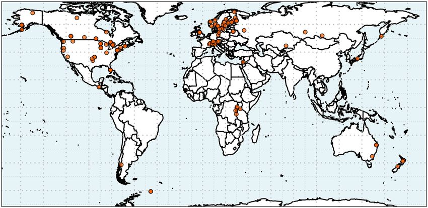
We present here a globally-expansive data set of vertical summertime temperature profiles of 153 lakes span-
ning 26 countries across all 7 continents (Fig. 1). Start and end years vary by lake, with starting years ranging
from 1894 to 2002 and ending years ranging from 1986 to 2016 (Fig. 2). The median number of years with
summertime vertical temperature profiles is 25 years, with a range from 3 to 96 years of data depending on the
#
A full list of authors and their affiliations appears at the end of the paper.
Scientific Data | (2021) 8:200 | https://doi.org/10.1038/s41597-021-00983-y 1www.nature.com/scientificdata/ www.nature.com/scientificdata
lake (Fig. 2). Lake characteristic data are also provided, including geographic, morphometric, and water quality
variables (Online-only Table 1; Supplementary Fig. S1).
Our goal was to assemble and publish this globally-expansive data set of lake vertical temperature profiles to
expand on prior global data sets of lake surface water temperatures25, and increase the understanding of changes
in deepwater temperatures and the full vertical thermal structure of lakes over time. A collaborative working
group at the Global Lake Ecological Observatory Network (GLEON; www.gleon.org) sought to analyze changes
in lake thermal structure at a global scale by collecting long-term vertical temperature profile data from a broad
range of lake types in order to address key scientific questions such as: How is vertical lake thermal structure
changing over time and depth? What types of lakes are experiencing the most rapid changes in temperature at
depth? How do trends in temperature at various depths or other metrics of thermal structure (i.e., mixing depth,
strength of stratification) vary among lakes? Through this data set, questions such as these can be more fully
addressed. This data set can be paired with meteorological or other climate or environmental data to analyze the
drivers of vertical thermal structure in comparison with the established drivers of surface water temperatures,
and to assess potential ecological consequences in times of global change. In addition, the data set can be used
to calibrate and evaluate lake models, such as the Lake Model Intercomparison Project26 (LakeMIP) and the
Inter-Sectoral Impact Model Intercomparison project27 (ISIMIP).
Methods
Temperature profiles, sampling methods, and physical descriptions were compiled for 153 globally-distributed
lakes. We selected vertical temperature profiles measured in the same location for multiple years, typically the
deepest part of the lake, using a single mid-summer profile for each lake and year. Data are presented for all
years for which profiles were available, with both raw vertical temperature profiles and interpolated vertical tem-
perature profiles presented. Depth increments for raw profiles vary by lake based on sampling methodology, as
described for each lake below. For interpolation, the selected temperature profiles were linearly interpolated or
binned to 0.5 m increments throughout the water column. Mid-summer profiles for each lake were selected as
described in (7). Briefly, we calculated relative thermal resistance to mixing28,29 (RTR) for all profiles for each
lake for each year. The day of year with the maximum RTR value for each year was selected for each lake, and the
median day of year across all years per lake was considered the target day for single mid-summer profile selection.
For each lake and year, the temperature profile nearest to this median day of year ± 21 days was selected. If no
profile spanning surface to near the maximum lake depth was available, then no profile was selected. Details on
sampling methods from each contributing research group follows, organized by major geographic region and
alphabetized within geographic region. Additional details for water chemistry sampling methods can be found in
the Supplementary Information (Supplementary Table S1).
Western North America. Castle Lake in California, USA has been sampled annually since 1959. Temperature
data were measured between 12:00 and 14:00 at the deepest part of the lake in 1 m depth intervals. Measurements
were taken using a reversing thermometer (1959–1975), Hydrolab (1975–1982; 2011–2013), and Yellow Springs
Instruments (YSI) model 85 (1999–2011) (sampling instrument is unknown for most of the 1980s and 90s).
Crater Lake is located in the northwestern USA at the crest of the Cascade Mountains in Oregon. Temperature
data were collected between 8:00 and 17:00 from the middle of the lake in the deepest basin. From 1988 to
present, temperature profiles were measured by lowering a Seabird Instruments SBE19 CTD through the water
column at a rate of approximately 0.5 m per second, collecting two readings per second. Data were binned to 1 m
increments. Prior to 1988, temperature profiles were measured manually with a Montedoro-Whitney thermistor
with a 250 m cable.
Emerald Lake, California, USA has temperature profiles measured from the deepest part of the lake beginning
in 1984. Temperature was measured in 1 m increments throughout the water column from 1984 to 2006 using a
YSI 58, after which a thermistor chain was deployed with Onset Water Temp Pro spaced at 0.5 to 1 m intervals.
Flathead Lake in northwest Montana, USA is the largest freshwater lake west of the Mississippi River by sur-
face area. Temperature data were collected fortnightly in June, July, and August 1978–2013 with various instru-
ments. From 1978–1984, data were collected with a Hydrolab I; from 1985–1993, with a Hydrolab Surveyor II;
from 1993–2003, with a Hydrolab Surveyor III; and from 2003–2001, with a Hydrolab Surveyor IV. Since 2011,
data have been collected with a Hydrolab DS5 unit. Measurements were taken between 10:00 and 14:00 at the
deepest point of the lake in 1 to 10 m depth intervals throughout the water column, with greater intervals between
measurements at deeper depths. The intervals between depths on a given sampling date also changed periodically
early in the data set before consistent intervals were established. Instrumentation was calibrated before each sam-
pling event to account for the elevation of the sampling site and highly variable barometric pressure.
Washington Lake is located in Washington, USA. Temperature profiles were measured between 9:00 and 16:00
in the main trench of the lake. Temperature was measured using various bathythermographs between 1933–1986,
a Kahl digital temperature meter 202WA510 beginning in 1974, and a YSI 6600 V2 sonde beginning in 2012. For
measurements with the bathythermographs, temperature was measured every 1 m close to the thermocline and
every 5 m elsewhere. When the Kahl temperature meter was used, temperature was recorded for every meter
through 20 m and in 5 m increments after 20 m depth. Data from the YSI sonde were recorded continuously, so
temperature readings were used at similar intervals to those from the previous instruments.
Central North America. Acton Lake is a eutrophic reservoir in southeastern Ohio, USA. Temperature was
measured in the deepest part of the lake at 0.5 m depth increments from 0 to 5 m and 1 m increments for the
remainder of the water column. Temperature data were typically collected in the mid-morning and occasionally
in the early afternoon in mid-July of each year from 1992–2012 using a handheld YSI temperature/dissolved
oxygen sensor or a YSI sonde.
Scientific Data | (2021) 8:200 | https://doi.org/10.1038/s41597-021-00983-y 2www.nature.com/scientificdata/ www.nature.com/scientificdata
Fig. 1 Map showing locations of the 153 lakes with vertical temperature profile data in this data set.
a b
100
Earliest year of data 25
Latest year of data
80
20
Number of lakes
Number of lakes
60
15
40 10
20 5
0 0
1890 1910 1930 1950 1970 1990 2010 0 10 20 30 40 50 60 70 80 90 100
Year Number of years of data
Fig. 2 Histograms of temporal coverage for each lake in this data set. (a) Histogram of the earliest year (green)
and latest year (orange) with temperature profile data for each lake. (b) Histogram of the total number of years
with temperature profile data for each lake.
Lakes Bighorn, Harrison, Pipit, and Snowflake are located along the eastern front range of the Rocky
Mountains in the Cascade Valley of Banff National Park (Alberta, Canada). Temperature data were collected
in the deepest point of the lake in 1 m depth intervals between 10:00 and 15:00 using a MK II Thermistor (Flett
Research Ltd, Winnipeg, Canada) for measurements taken beginning in the 1990s. Earlier measurements (1960s
and 1970s) were taken using a YSI Model 425 C thermistor thermometer, which was calibrated against a mercury
thermometer.
Douglas Lake is a mildly eutrophic glacially formed multiple ice-block kettle lake in northwestern Cheboygan
County, Michigan, USA. Temperature data were collected from 1913–2014 at 1 m intervals from 0 to 24 m in the
center of South Fishtail Bay Kettle with a reversing thermometer at approximately 1 m increments (1913–1970),
a YSI model 54 A oxygen electrode-thermistor thermometer (1971–1982), a Hydrolab MS-5 multiprobe (1983–
2009), and an 8-node MHL thermistor string (2010–2014).
Lakes Eucha, Grand Lake O’ the Cherokees, Spavinaw, Texoma, and Thunderbird are reservoirs located in
Oklahoma, USA. Temperature profiles were measured at the deepest point in these reservoirs between morn-
ing and mid-day with various sensors. YSI temperature probes were used for all samples collected in Lake
Thunderbird, through 1991 in Grand Lake O’ the Cherokees, through 1995 in Lakes Eucha and Spavinaw, and
through 2000 in Lake Texoma. Beginning in 2000 in Lake Texoma, Hydrolabs were used for temperature meas-
urements, with a Hydrolab H2O through 2008, and Hydrolab DSX5 thereafter. A Hydrolab was used for meas-
urements in Grand Lake O’ the Cherokees from 2011–2013. Lakes Eucha and Spavinaw were sampled with a
Hydrolab H2O through 2005, a YSI 6930 V2 for samples from 2006–2012, and a YSI EXO1 for samples after 2012.
Scientific Data | (2021) 8:200 | https://doi.org/10.1038/s41597-021-00983-y 3www.nature.com/scientificdata/ www.nature.com/scientificdata
Katepwa Lake is a eutrophic, riverine site located in the Qu’Appelle River drainage basin in southern
Saskatchewan, Canada. The lake has been sampled since 1994 as part of the Qu’Appelle Long-term Ecological
Research network (QU-LTER). Temperature data were collected from a standard deep site in 1 m intervals
between 10:30 and 13:00 using a YSI 85 or similar multi-parameter probe.
Northeastern North America. Temperature profiles were collected beginning in 1969 for six lakes (Lakes
222, 224, 239, 240, 373, and 442) at the IISD Experimental Lakes Area (International Institute for Sustainable
Development, Northwestern Ontario, Canada). Profiles were measured in the deepest part of the lake in 1 m
intervals, except in the thermocline where temperature was measured every 0.25 m. Montedoro-Whitney ther-
mistors (models TC-5A and TC-5C) were used through 1983, a Flett Research Mark II digital telethermometer
was used for temperature measurements from 1984–2009, and a RBR XRX620 multifunction probe with inte-
grated temperature sensor for measurements beginning in 2010.
The Dorset “A lakes”, Blue Chalk, Chub, Crosson, Dickie, Harp, Heney, Plastic, and Red Chalk Lakes are
located in the Muskoka-Haliburton region of south-central Ontario, Canada. The study sites are primarily
small headwater lakes, with the exception of Red Chalk Lake which is located downstream of Blue Chalk Lake.
Temperature data were collected from the deepest point in each lake using a YSI 58 temperature/dissolved oxygen
meter (or occasionally a digital YSI 95 meter) beginning in the late 1970s. Measurements were collected between
9:00 and 16:00, with readings taken every 1 m from the lake surface (0.1 m depth) to within approximately 1 m of
lake sediments.
Bubble Pond, Eagle Lake, and Jordan Pond are located on Mount Desert Island off the coast of Maine, USA.
Temperature data were collected from the location of the maximum depth at 1 m increments using a YSI 600XL
multiparameter water-quality monitor (sonde) from 2006 to present and a YSI 54ARC before this time.
Lake Champlain is located in the northeastern USA, on the border of Vermont and New York state and partly
extending into Quebéc, Canada. Temperature data were collected from a sampling station in Mallet’s Bay begin-
ning in 1992. Measurements of temperature were taken at 1 m intervals between 8:00 and 17:00 using a Hydrolab
MS-5 multi-probe sonde.
Clearwater, Sans Chambre, and Whitepine Lakes are located in northeastern Ontario, Canada, and Hawley
Lake is in the Hudson Bay Lowlands area of subarctic Ontario, Canada. Temperature profiles were measured
from near the area of maximum depth, beginning in the 1970s in Clearwater and Hawley, and beginning in the
1980s in Sans Chambre and Whitepine. Measurements were taken in 1 m intervals through the water column
between 12:00 and 17:00. Clearwater, Sans Chambre, and Whitepine Lakes’ temperature profiles were measured
using various YSI temperature/dissolved oxygen meters (models 50B, 51B, 52, 54, or 58) beginning in 1998,
with a YSI model 54 temperature/dissolved oxygen meter used for Sans Chambre and Whitepine for most ear-
lier years’ measurements. In Clearwater Lake, a YSI model 432D telethermometer was used through 1975, a
Montedoro-Whitney TC-5C thermistor from 1976–1981, and a Mark II Telethermometer from 1982–1998. In
Hawley Lake, various YSI temperature probes were used in earlier years, and since 2009, a YSI Pro ODO meter
was used to measure water temperature.
Lakes Giles and Lacawac are located in the Pocono Mountains region of Pennsylvania, USA. Temperature data
were collected from the deepest point in the lake in late July or early August each year beginning in 1988, between
9:00 and 16:00. Temperature measurements were measured in 1 m increments using a YSI 58 temperature/dis-
solved oxygen meter (1988–1992), or with a rapid recording Biospherical Instruments PUV 500 (1993–2003) or
BIC 2104 P (2004-present) recording at 4 Hz while being lowered through the water column. Profiles taken with
the YSI were linearly interpolated to 0.5 m depth increments, and profiles taken with the PUV and BIC were
binned to 0.5 m depth increments.
Lake Lillinonah is a reservoir on the Housatonic River located in western Connecticut, USA. Temperature
data were collected at the deepest point of the lake between 9:00 and 17:00 beginning in 1996 by First Light Power.
Measurements were collected every 5 m using a YSI 58 temperature/dissolved oxygen meter.
Mohonk Lake is a small glacial lake with a single deep basin located at the Shawangunk Ridge, New York, USA.
Temperature data were collected from the northern end of the lake from 1984–2013 during daytime. Temperature
measurements were measured manually in 1 m increments using Digi-sense Economical Thermistor 400 series
(Model #93210-00). Additional weekly temperature profiles are publicly available30.
Temperature profiles were compiled from 11 lakes from the North Temperate Long Term Ecological Research
Network in Wisconsin, USA. Fish, Mendota, Monona, and Wingra Lakes are located in southern Wisconsin, and
Allequash, Big Muskellunge, Crystal Bog, Crystal Lake, Sparkling, Trout Bog, and Trout Lake are in northern
Wisconsin. Temperature profiles were measured in 1 m increments from the surface to lake bottom at the deepest
location in each lake since 1981 (northern lakes) and 1995–1996 (southern lakes), and since 1894 in Mendota31.
Various temperature/dissolved oxygen probes were used to collect these data, and were calibrated in the field
prior to data collection. For the northern lakes, a Montedoro Whitney CTU-3B sensor was used for some data
collected between 1981–1986, a Whitney TC-5C for 1982–1983, Whitney DOR-2A in 1984, YSI-57 in 1983 and
1985, and a YSI-58 for 1985 onward. Temperature data in the southern lakes were collected with a YSI-58 tem-
perature/dissolved oxygen sensor.
Lake Opeongo is the largest oligotrophic deepwater lake in Algonquin Provincial Park, Ontario, Canada.
Temperature data were collected by Ontario Ministry of Natural Resources and Forestry staff at Harkness
Fisheries Research Station in the west basin of Opeongo’s South Arm in midsummer in 1958–1965, and between
9:00 and 16:00 in 1998–2014. Temperature loggers (Hobo Tidbits, 1998–2004; Onset Water Temperature Pro V1,
2004–2008; and Onset Pro V2, 2009–2014) were installed after ice out in the same location at approximately 1.5 m
intervals to a 15 m depth, with a deepwater thermistor placed at approximately 20 m. Temperatures were recorded
at high temporal resolution (10 to 15 minute intervals) throughout the summer using these temperature strings.
Earlier (1958–1965) temperature profiles were measured using handheld thermistors.
Scientific Data | (2021) 8:200 | https://doi.org/10.1038/s41597-021-00983-y 4www.nature.com/scientificdata/ www.nature.com/scientificdata
Lake Sunapee is the fifth largest lake located within New Hampshire, USA. Temperature data were collected
in the morning from the deepest point of the lake in the central basin beginning in 1986. Temperature measure-
ments were measured manually in 1 m increments using a YSI 52 temperature meter.
Lake Wallenpaupack is a reservoir in the Pocono Mountains region of Pennsylvania, USA. Temperature pro-
files were measured in the center of the lake during daytime hours, with measurements taken every 0.5 to 1 m.
Temperature was measured with various YSI instruments including a YSI 610-DM/600XL (2002–2005), YSI 85
(2008–2010), YSI 600XL sonde with 600D datalogger (2011–2012), and various temperature sensors prior to
2002.
Southeastern North America. Lake Annie is located in the Lake Wales Ridge region, Florida, USA.
Temperature data were collected from the deepest point in the lake on a monthly basis between 9:00 and 16:00
beginning in 1984. Temperature measurements were measured manually in 1 m increments using a Montedoro
Corporation Thermistor Model TC-5c (1984–2008) and a YSI Pro Plus (2009–2014) with values measured while
lowering the meter to the bottom of the lake and again when raising it to the surface. The data reported are the
means of the two depth-specific values.
Temperature data were measured in Lake Okeechobee in Florida, USA beginning in 1973. Temperature data
were measured near the surface at approximately 0.2 m between 8:00 and 12:00 using a Hydrolab through 1995
and a YSI 58 temperature sensor from 1996–2014.
Subarctic. Aleknagik, Beverley, Chignik, Hidden, Kulik, Little Togiak, Lynx, and Nerka Lakes are located in
Alaska, USA. Temperature profiles have been measured on these lakes since the 1960s (Aleknagik, Beverley, Kulik,
Little Togiak, and Nerka Lakes), and since the early 2000s (Chignik, Hidden, and Lynx Lakes). Measurements
were taken during the day, typically between 10:00 and 19:00. A bathythermograph was used for temperature
measurements through 1967, a digital thermistor from 1968–1998, a YSI 660 sonde for samples from 1999–2012,
and a YSI Castaway beginning in 2013, with the exception of samples from Chignik Lake, for which a handheld
thermometer was used to measure the water temperature from Van Dorn casts.
Toolik Lake is a kettle lake located in Alaska, USA. Temperature data were collected between June and August
in the south basin of the lake between 9:00 and 11:00. Temperature was recorded in 1 m increments throughout
the water column with a Hydrolab profiler sampling Surveyor 4a datalogger and a datasonde 4a multiprobe32–35.
Vulture Lake is located in the sub-Arctic region of the Northwest Territories, Canada. Temperature data were
collected from one of the deeper parts of the lake in late July or early August during the open-water season from
1997–2014. Temperature measurements were recorded using a multi-probe sonde (e.g., YSI 6820) at 0.5 m or
1 m increments (every 1 m for most years, except 1999 [every 0.5 m] and 2009 [every 0.2 m]). The corresponding
depth was measured using the readings from the depth sensor. Measurements were collected continuously from
just below the lake’s surface to approximately 0.5 m above the water-sediment interface. Sensors equipped on pro-
filing instruments were calibrated following the manufacturer’s recommended frequency and methods to ensure
accurate and reliable operation of the sensors in the field.
Central and South America. Lake Atitlán is a deep tropical mountain lake in the Guatemalan highlands,
sampled in 1968–1969 and 2010–2011. Temperature profiles at the lake center were measured manually between
7:00 and 13:00 in variable increments (1 to 5 m) in the first 30 m using a YSI 51 or YSI 95 temperature/dissolved
oxygen meter. For depths below 30 m, samples were collected using a Van Dorn bottle and temperature was meas-
ured immediately upon the sample reaching the surface.
Lake Mascardi is located in the North Patagonian Andes in Argentina. Temperature data were collected near
the deepest point in the Catedral arm of the lake in mid-summer (January-February) between 12:00 and 14:00
beginning in 1994. Temperature measurements were taken using rapid recording Biospherical Instruments PUV
500 (1994) or PUV 500B (1996–2014) recording at 4 Hz while being lowered through the water column.
Africa. Lake Kivu is located on the border between Rwanda and the Democratic Republic of Congo, and is
one of the seven African Great Lakes. Temperature data were collected in the Ishungu basin beginning in 2002
between 9:00 and 16:00. Temperature was measured in 5 m increments using a YSI 55 temperature/dissolved
oxygen meter (2002–2005), or with a suite of instruments (YSI 6600 V2, Hydrolab DS4a, DataSonde 4a 42071,
Sea and Sun 725 and 257) recording at high frequency while being lowered through the water column. All tem-
perature profiles were vertically interpolated to a regular vertical grid with 1 m increments using piecewise cubic
Hermite interpolation18,26.
Lake Nkugute is located in Uganda. Temperature data for Lake Nkugute were collected in the deepest part of
the lake at a depth interval of 1 to 5 m using a liquid-in-glass thermometer set in a Ruttner sampler in 1964 with
the contemporary (2002-present) data being measured with a YSI sonde.
Lake Nkuruba is located in western Uganda, in the vicinity of Kibale National Park (northern sector).
Temperature data were collected beginning in 1992 from the deepest part of the lake in 1 m increments through a
depth of approximately 30 m. Temperature was measured manually using a YSI 50 or 51B temperature/dissolved
oxygen meter.
Lake Tanganyika has temperature profile data dating back to 1912. Temperature profiles in this lake were typ-
ically measured in the morning, between 9:00 and 12:00 from the north basin of the lake near Kigoma, Tanzania.
Temperature profiles over this century of data collection have been taken using a multitude of instruments. Since
1993, temperature profiles have been measured using a YSI 6600 V2 sonde, titanium RBRduo TD, Seacat Profiler
V3.1b, Onset HOBO U22 temperature loggers, CTD Seabird 19, STD-12 Plus CTP profiler, and a YSI 58 tem-
perature/dissolved oxygen meter. Prior to 1993 various methods were used, including measurement of water
Scientific Data | (2021) 8:200 | https://doi.org/10.1038/s41597-021-00983-y 5www.nature.com/scientificdata/ www.nature.com/scientificdata
temperature from Van Dorn casts with a mercury thermometer, various data loggers, reversing thermometers,
and Niskin bottles and a bathythermograph36.
Lake Victoria is shared between Tanzania, Uganda, and Kenya. Temperature data were collected from stations
across the lake during acoustic surveys each year in 2000–2001 and in 2008 using a submersible Conductivity
Temperature-Depth profiling system (CTD, Sea-bird Electronics, Sea Cat SBE 19).
Scandinavia and Northern Europe. Lakes Allgjuttern, Brunnsjön, Fiolen, Fracksjön, Övre Skärjön,
Remmarsjön, Rotehogstjärnen, St. Skärsjön, Stensjön, and Stora Envättern are relatively small, boreal lakes in
Sweden. In contrast, Lake Vänern is the largest lake in Sweden. Temperature data have been collected since 1988
(since 1973 for Lake Vänern) between morning and mid-afternoon. Temperature measurements were taken from
the deepest point in each lake from the surface through 1 m above the lake bottom at depth intervals varying
between 1 m and up to 10 m (in Lake Vänern).
Lakes Byglandsfjorden, Hornindalsvatnet, Mjøsa, Øyeren, Selbusjøen, and Strynevatnet are all large and deep
lakes located in the central region of western Norway. Temperature profiles were measured in the deepest part
of the lake between 9:00 and 16:00 beginning in the mid-1990s. Temperature was measured using an Aanderaa
4060 every meter in the upper part of the water column, with greater than 1 m intervals between measurements
in depths below 20 m. For the past 2 to 3 years of data collection, a Castaway CTD recorded temperatures while
lowered. Data collection was made by The Norwegian Water Resources and Energy Directorate (NVE).
Temperature data were collected from Sweden’s Lake Erken from the deepest point in the lake in 1 m intervals
between 7:30 and 9:30 beginning in 1940. Temperature was measured at 1 m intervals using a variety of instru-
ments. In early years, a thermometer inside a transparent Ruttner sampler was read to obtain the temperature of
water collected from different depths. Later, underwater thermistors were used from a variety of manufacturers.
In recent years, combined temperature and dissolved oxygen sensors have been used to collect water temperature
measurements: a YSI model 52 (1996–2006), WTW Oxi 340i (2006–2012), and Hach HQ40d sensor system
(2012-present).
Lakes Inarijärvi, Kallavesi, Konnevesi, Näsijärvi, Päijänne, Pielinen, and Pyhäjärvi are generally large lakes
located throughout Finland, from southern Finland to the northern-most part of the country (Lapland). Lake
Pesiöjärvi in the same region has a significantly smaller surface area than others. Lakes Konnevesi and Päijänne
have two different temperature profile sites (Konnevesi: Näreselkä and Pynnölänniemi, Päijänne: Linnasaari and
Päijätsalo). Temperature data were typically collected in the deepest part of the lake, or in case of large fragmented
lakes, the deepest part of the respective basin. Reversing mercury thermometers (with or without Ruttner water
samplers) were used until the digital temperature measurements were introduced in the early 1970s. HL Hydrolab
Ab PT77A (approximately 1975–1995), DeltaOhm HD8601P (1995–2005), and HT Hydrotechnik Type 110
(2005–2014) have been used for measuring water temperature profiles. However, all device types have been used
at each station as long as they have worked. Unfortunately, site-specific documentation of devices used during
different years are not available. Before the 1980s, measurements were collected every 5 m before and every 10 m
after a depth of 20 m. Since 1980–1981, measurements have been made in 1 m intervals from the surface through
20 m, every 2 m from 20 to 50 m, and every 5 m past 50 m.
Lake Pyhäselkä (Pyhaselka) is a large, humic lake located in North Karelia, Finland. It is the northernmost
basin of the Saimaa lake system. Temperature data were collected from the deepest point in the lake (Kokonluoto)
in 5 m depth intervals beginning in 1962 between 8:00 and 16:00 using a thermometer in a Ruttner water sampler.
Central Europe. Lakes Annecy, Bourget, and Geneva are located in eastern France37. Temperature data were
collected from the deepest point in the lake between 9:30 and 11:00, beginning in 1991 for Lake Annecy, in
1984 for Lake Bourget, and in 1974 for Lake Geneva. In Lake Annecy, various multiparameter probes, including
Meerestechnik Elektronik (1991–2001), CTD 90 (2003–2005), CTD 90 M (2008–2011, 2013), and RBR (2012)
were used for temperature measurements at depth intervals between 0.01 and 1.8 m. Temperature profiles were
measured in Lake Bourget at depth intervals between 0.01 and 10 m using various multiparameter probes, includ-
ing ISMA probe DNTC (1984–1985), Meerestechnik Elektronik ECO 236 (1986–1998), CTD SBE 19SeaCAT
Profiler (1992–2002), and CTD SBE 19plus V2 SeaCAT (2003–2013). In Lake Geneva, water temperature was
measured from water samples with a thermometer until 1990 from discrete depths of 5 to 10 m intervals through
50 m depth and approximately 50 m intervals for the rest of the water column. After 1990 various multiparameter
probes were used for temperature measurements, including Meerestechnik Elektronik (1991–2001), CTD 90
(2002–2007), CTD 90 M (2008–2011, 2013), and RBR (2012). Data for Annecy, Bourget, and Geneva are available38
at https://data.inrae.fr/dataset.xhtml?persistentId=doi:10.15454/YOLA0Y.
The Cumbrian lakes in the English Lake District, Bassenthwaite Lake, Blelham Tarn, Derwent Water, Esthwaite
Water, Grasmere, and Windermere North Basin, are located in northwest England. Temperature data were col-
lected in midsummer at the deepest point of each between 9:00 and 14:00 beginning in 1991. Temperature profiles
were measured at depth intervals judged in the field depending on the stratification pattern and depth of the lake.
Temperature was measured with various combined temperature/oxygen sensors, including a YSI 58 (1991–2002)
and WTW Oxi 340 (2002–2013) in Windermere North Basin, and a YSI 58 (1991–2002), WTW Oxi 340i (2002–
2010), and Hach HQ 30d and LDO probe (2010–2013) in all other lakes.
Lake Constance is located on the border of Germany, Switzerland, and Austria. Temperature profiles were
measured at the deepest part of the central basin (Upper Lake Constance) of the lake beginning in 1964, with
measurements taken between 9:00 and 10:00 using a thermometer. Depth intervals between samples increased
with depth, with measurements taken every 2.5 to 5 m through 20 m, every 10 m through 50 m, and every 50 m
down to a depth of 250 m39.
Lake Mondsee is located in the Lake District “Salzkammergut” of Austria. Temperature data were col-
lected from the deepest point of the lake approximately monthly near noon beginning in 1968. Temperature
Scientific Data | (2021) 8:200 | https://doi.org/10.1038/s41597-021-00983-y 6www.nature.com/scientificdata/ www.nature.com/scientificdata
measurements were usually measured at depth intervals of 1 to 2 m in the epilimnion and 5 to 10 m intervals in
the hypolimnion using a thermometer housed in a Schindler sampler prior to 1998. Beginning in 1998, data were
extracted from continuous YSI 6920 profiler readings, with a YSI 6600 used beginning in 2008 and a thermistor
chain from 2010–2013.
Lake Müggelsee, located in Berlin, Germany was sampled weekly beginning in 1978 between 8:00 and 9:00.
Temperature was measured every 0.5 to 1 m at the deepest part of the lake using a Hydrolab H2O sensor begin-
ning in 1992, and a thermistor probe for years prior to 1992.
Lake Piburgersee is located in Tyrol, Austria. Temperature was measured using a calibrated thermometer
every 3 m throughout the water column in the deepest part of the lake, beginning in 1970. Additional information
and analyses are available elsewhere40.
Plusssee (Plußsee) is located in northern Germany (Schleswig-Holstein). Temperature data were collected
from the deepest point of the lake between 9:00 and 15:00 beginning in 1971. Temperature was measured manu-
ally in 1 m increments from 0 to 15 m and in 5 m increments from 15 to 25 m using a thermometer mounted into
a Ruttner sampler prior to 1976, and after 1976 with a WTW temperature/dissolved oxygen probe.
Traunsee is a large and deep oligotrophic lake in the Salzkammergut lake district of Austria. Temperature
data were collected at the deepest point of the lake between 9:00 and 12:00 beginning in 1965. Temperature was
measured at 2 to 5 m intervals through 20 m, and at 20 m intervals through the rest of the water column using a
mercury thermometer mounted in a 5-liter water sampler.
Lower Lake Zurich is located in Switzerland. Temperature profiles were measured at the deepest part of this
lake between 8:30 and 12:00 beginning in 1936. Measurements were taken at the deepest point in the lake using a
range of sensors, mainly NTC thermistors (1936–2000). Beginning in 2001 various sondes were used, including
FLP-10 multisonde (2001–2008), multisonde Hydrolab DS5 (2008–2015) at 0.5 to 1 m intervals through 30 m, 5 m
intervals through 50 m, and 10 m intervals throughout the rest of the water column.
Southern Europe. Lake Garda is one of the largest lakes in Europe, and the largest Italian lake. Owing to its
deep depth, Lake Garda is characterized by long periods of incomplete vertical winter water circulation, which are
interrupted by full mixing of the water column after the occurrence of harsh winters. Limnological investigations
have been carried out since 1991 in a pelagic station located at the point of maximum depth of the northwest
basin. Profiles of water temperature were recorded during the summer months using Idronaut Ocean Seven 401
(1991–1997), Seacat SBE 19–03 (1998–2008), and Idronaut Ocean Seven 316Plus since 200925.
Lake Iseo is located in northern Italy (Lombardy Region). It is a deep mesotrophic lake, characterized by long
periods of incomplete vertical winter water circulation41. Temperature was measured at the deepest point in the
lake using an automatic thermistor probe coupled with an oxygen sensor from 1993 to 2011 with Microprocessor
Oximeter WTW OXI 320 and from 2012 to 2016 with Microprocessor WTW multi 3410. Temperature was meas-
ured for at least ten discrete depths and all measurements were regularly checked with a mercury-filled Celsius
reversing thermometer.
Lake Lugano is located in the foothills of the Central Alps, on the border between Switzerland and Italy.
The lake is divided into a northern and southern basin, which are separated by a causeway (built on a natural
moraine). Due to reduced connectivity42 (flow of approximately 0.38 km3 year−1 from north to south) and differ-
ent morphometric characteristics, the two basins were considered separately in the data set. Temperature profiles
were collected at sites near the deepest point of each basin. Temperature was measured using reversing thermom-
eters from 1974–1979 and multiparameter probes thereafter (Hydropolyester HTP 77 during 1980–1985, Ocean
Seven 401 during 1986–1993, Ocean Seven 316 during 1994–2015). As an exception, temperatures at depths
greater than 100 m were also measured using a reversing thermometer between 1980–1985. Temperature was
measured for at least nine or seven discrete depths for the northern and southern basins, respectively, from 1974–
1986, whereas full temperature profiles with vertical resolution of 0.5 to 1 m were measured between 1987–2015.
Lake Maggiore is a deep lake located in northwestern Italy and Switzerland, south of the Alps. Lake Maggiore
can be classified as holo-oligomictic, with complete overturns only occurring at the end of particularly cold
and windy winters. Temperature data have been collected at the deepest point of the lake since 1981, usually
between 10:00 and 12:00 at the Ghiffa station. Temperature has been measured at discrete depths of 0, 5, 10, 20,
30, 50 m, and every 50 m through 360 m using mercury-filled thermometers connected to the bottle used for
water sampling43.
Eastern Europe. Lakes Batorino, Myastro, and Naroch are located in the northwest part of Belarus, in the
glacial landscape. Temperature data were collected monthly in the center of the lake during the vegetative season
of May to October beginning in the 1950s and 60s. Measurements of water temperature were taken every 2 to 4 m
through the water column between 9:00 and 14:00 with a mercury deepwater thermometer with a scale resolution
of 0.1°C mounted in a metal frame, or in a Ruttner sampler.
Russia. Lake Baikal is located in Siberia, Russia. Temperature data were collected from a station situated
2.8 km from the shoreline near the Bolshie Koty settlement at depths of 0 and 50 m between 9:00 and 12:00 from
1948–2009. Temperature was measured with a mercury thermometer inside a Van Dorn bottle.
Lake Glubokoe is located in Central European Russia, Moscow Province. Temperature profile data were col-
lected from the deepest point of the lake from the surface through 10 m. Since 1982, water was taken from the
required depth with a 10 L bathometer and its temperature was measured with a mercury thermometer; instru-
mentation prior to 1982 is unknown.
Kurilskoye Lake in Kamchatka, Russia was sampled beginning in 1942. Temperature profiles were measured
in the deepest part of the lake between 8:00 and 15:00. Various temperature sensors were used over time, includ-
ing a reversing thermometer (1942–1965), bathythermograph (1980–2003), Hydrolab (2004–2008), and RINKO
profiler (2009–2014).
Scientific Data | (2021) 8:200 | https://doi.org/10.1038/s41597-021-00983-y 7www.nature.com/scientificdata/ www.nature.com/scientificdata
Lake Shira is located in the south of Siberia, Russia. Temperature profiles were measured in the deepest part
of the lake between 11:00 and 15:00 from the surface to the depth of 20 to 24 m with various temperature sensors
including multisonde Hydrolab 4 A (2000–2008) and a YSI 6600 (2009–2014).
Middle East. Lake Kinneret is located in Israel (Jordan Valley). Temperature data were collected near the
deepest point of the lake (Station A) between 7:00 and 16:00 from 1969–2013, measured every centimeter with
an error of ± 0.005 °C, and averaged to every 1 m. Temperature measurements were taken from 1969 to 1986
using an underwater thermometer (Whitney-Montedoro), from 1987 to 2003 using a STD-12 Plus (Applied
Microsystems), and from 2003 to 2013 using AML Oceanographic Minos•X.
Asia. Lake Biwa is located in the central part of the Japanese archipelago (Shiga Prefecture, Japan). Temperature
data were collected from a station near the deepest part of the lake from 1958–2010. Temperature was mostly
measured between 9:00 and 12:00 at 5 m intervals from 1959–2005, and at 1 m intervals beginning in 2006.
Measurements were made using an electronic thermometer (Murayama Denki Ltd.) from 1958–1970, a ther-
mistor thermometer (Shibaura electronics, HCB III) from 1970–1994, a CTD profiler (Alec electronics, ABT-1)
from 1994–2006, and a CTD profiler (JFE Advantech, compact-CTD) from 2007–2010.
Australia. Lake Burley Griffin is a reservoir constructed in 1963 by damming the Molonglo River. It is located
in the geographic center of Canberra, the capital of Australia. Temperature data were collected from the deepest
point of the reservoir, near the dam wall. Profiles were measured in 1 m depth intervals (reduced to 3 m intervals
in 1992) between 8:45 and 16:15 from 1981–2010 by the National Capital Authority.
Lakes Samsonvale (North Pine) and Somerset are located on the east coast of Australia, in southeast
Queensland. Temperature in each lake was measured at a site approximately 100 m from the dam wall.
Samsonvale’s (North Pine’s) temperature was measured using a YSI 6560 sensor on a YSI 6600 V2 sonde begin-
ning in 2009 continuously over a 24-hour period at 1 m intervals. Prior to 2009, temperature was measured via
a thermistor string with various unknown instruments. Somerset’s temperature profiles from 2000–2002 were
measured using temperature sensors on a thermistor string, spaced at 0.5 m intervals through 3 m, 1 m intervals
through 7 m, 2 m intervals through 17 m, and 3 m intervals for the rest of the water column.
New Zealand. Lakes Brunner and Taupo are located in New Zealand, in the West Coast and Waikato regions,
respectively. Temperature profiles were measured at the deepest part of these lakes between 9:00 and 16:00, begin-
ning in the early 1990s. Temperature was measured by lowering CTD profilers through the water column, using
an YSI EXO sonde (Brunner) and RBR profiler (Taupo).
Lakes Okareka, Okaro, Okataina, Rerewhakaaitu, Rotoehu, Rotoiti, Rotoma, Rotorua, Tarawera, and Tikitapu
are located in Rotorua, Bay of Plenty, New Zealand. Temperature profiles were measured between 10:00 and 14:00
in the central basin using Seatech CTD casts with a Seabird 19Plus or 19PlusV2 beginning in 2003. Temperature
was measured at a frequency of 4 Hz during each cast and data were binned to 1 m depth intervals. Profiles before
2003 were measured in 1 m depth intervals with either a YSI Water Quality Logger 3800 or YSI Sonde model 3815.
Antarctica. Lakes Heywood (1962–1995), Moss (1972–2003), and Sombre (1973–2003) are located in the
South Orkney Islands, Antarctica. Temperature data from these lakes were collected using a Mackareth-type
probe at 1 to 2 m intervals in the deepest part of the lake.
Data Records
Data are presented in three comma delimited files44. The first contains the pertinent metadata for each lake
(“SiteInformation.csv”), including information about the source and contacts for each lake, sampling details,
and the geographic, morphometric, and water quality characteristics (Online-only Table 1). The second two
files contain the raw (“TempProfiles_Raw.csv”) and interpolated vertical temperature profiles (“TempProfiles_
Interpolated.csv”) from each summer for each lake. These three files can all be linked with the LakeID column pres-
ent in each file. All files are available at the Environmental Data Initiative, accessible at https://portal.edirepository.
org/nis/mapbrowse?scope=edi&identifier=705. Additional information, details, and methods can be acquired
by contacting the data providers at the emails found in “SiteInformation.csv”.
Technical Validation
Quality control and assurance of temperature profile data was completed iteratively at multiple steps to ensure
quality of all data. Both raw and interpolated data were visually inspected using contour maps to assess data
accuracy over depth and time. At this stage, any data points that appeared inaccurate were removed, and then
linear interpolation was re-run to fill in the missing data gaps. We used the same process to visually check vertical
temperature data over depth and time following selection of single summer profiles for each lake. We also visually
inspected time series plots of surface and deepwater temperature for each lake over time as an additional quality
check. Any suspect vertical temperature profiles were removed, and, when possible, replaced with another tem-
perature profile from the same lake with a similar sampling date.
Code availability
All data compilation and creation of figures were conducted in R version 4.0.245. R code can be found at https://
www.github.com/rmpilla/GlobalTempProfileData.
Received: 12 February 2021; Accepted: 18 June 2021;
Published: xx xx xxxx
Scientific Data | (2021) 8:200 | https://doi.org/10.1038/s41597-021-00983-y 8www.nature.com/scientificdata/ www.nature.com/scientificdata
References
1. Adrian, R. et al. Lakes as sentinels of climate change. Limnol. Oceanogr. 54, 2283–2297 (2009).
2. Williamson, C. E., Saros, J. E., Vincent, W. F. & Smol, J. P. Lakes and reservoirs as sentinels, integrators, and regulators of climate
change. Limnol. Oceanogr. 54, 2273–2282 (2009).
3. Schneider, P. & Hook, S. J. Space observations of inland water bodies show rapid surface warming since 1985. Geophys. Res. Lett. 37,
1–5 (2010).
4. O’Reilly, C. M. et al. Rapid and highly variable warming of lake surface waters around the globe. Geophys. Res. Lett. 42, 1–9 (2015).
5. Kraemer, B. M. et al. Morphometry and average temperature affect lake stratification responses to climate change. Geophys. Res. Lett.
42, 1–8 (2015).
6. Richardson, D. C. et al. Transparency, geomorphology and mixing regime explain variability in trends in lake temperature and
stratification across Northeastern North America (1975-2014). Water 9, 1–22 (2017).
7. Pilla, R. M. et al. Deeper waters are changing less consistently than surface waters in a global analysis of 102 lakes. Sci. Rep. 10, 20514
(2020).
8. Pilla, R. M. et al. Browning-related decreases in water transparency lead to long-term increases in surface water temperature and
thermal stratification in two small lakes. J. Geophys. Res. Biogeo. 123, 1651–1665 (2018).
9. Woolway, R. I. & Merchant, C. J. Worldwide alteration of lake mixing regimes in response to climate change. Nat. Geosci. 12,
271–276 (2019).
10. Foley, B., Jones, I. D., Maberly, S. C. & Rippey, B. Long-term changes in oxygen depletion in a small temperate lake: Effects of climate
change and eutrophication. Freshwater Biol. 57, 278–289 (2012).
11. Knoll, L. B. et al. Browning-related oxygen depletion in an oligotrophic lake. Inland Waters 8, 255–263 (2018).
12. Verburg, P., Hecky, R. E. & Kling, H. Ecological consequences of a century of warming in Lake Tanganyika. Science 301, 505–507
(2003).
13. De Stasio, B. T., Hill, D. K., Kleinhans, J. M., Nibbelink, N. P. & Magnuson, J. J. Potential effects of global climate change on small
north-temperate lakes: Physics, fish, and plankton. Limnol. Oceanogr. 41, 1136–1149 (1996).
14. Cohen, A. S. et al. Climate warming reduces fish production and benthic habitat in Lake Tanganyika, one of the most biodiverse
freshwater ecosystems. P. Natl. Acad. Sci. 113, 9563–9568 (2016).
15. Hansen, G. J. A., Read, J. S., Hansen, J. F. & Winslow, L. A. Projected shifts in fish species dominance in Wisconsin lakes under
climate change. Glob. Change Biol. 23, 1463–1476 (2017).
16. Schmid, M. & Köster, O. Excess warming of a Central European lake driven by solar brightening. Water Resour. Res. 52, 8103–8116
(2016).
17. Woolway, R. I., Meinson, P., Nõges, P., Jones, I. D. & Laas, A. Atmospheric stilling leads to prolonged thermal stratification in a large
shallow polymictic lake. Climatic Change 141, 759–773 (2017).
18. Thiery, W. et al. Understanding the performance of the FLake model over two African Great Lakes. Geosci. Model Dev. 7, 317–337 (2014).
19. Gaiser, E. E., Bachmann, R., Battoe, L., Deyrup, N. & Swain, H. Effects of climate variability on transparency and thermal structure
in subtropical, monomictic Lake Annie, Florida. Fundam. Appl. Limnol. 175, 217–230 (2009).
20. Read, J. S. & Rose, K. C. Physical responses of small temperate lakes to variation in dissolved organic carbon concentrations. Limnol.
Oceanogr. 58, 921–931 (2013).
21. Rose, K. C., Winslow, L. A., Read, J. S. & Hansen, G. J. A. Climate-induced warming of lakes can be either amplified or suppressed
by trends in water clarity. Limnol. Oceanogr. Lett. 1, 44–53 (2016).
22. Winslow, L. A., Read, J. S., Hansen, G. J. A. & Hanson, P. C. Small lakes show muted climate change signal in deepwater temperatures.
Geophys. Res. Lett. 42, 355–361 (2015).
23. Fee, E. J., Hecky, R. E., Kasian, S. E. M. & Cruikshank, D. R. Effects of lake size, water clarity, and climatic variability on mixing
depths in Canadian Shield lakes. Limnol. Oceanogr. 41, 912–920 (1996).
24. MacIntyre, S. et al. Climate related variations in mixing dynamics of an Alaskan arctic lake. Limnol. Oceanogr. 54, 2401–2417 (2009).
25. Sharma, S. et al. A global database of lake surface temperatures collected by in situ and satellite methods from 1985–2009. Sci. Data
2, 150008 (2015).
26. Thiery, W. et al. LakeMIP Kivu: Evaluating the representation of a large, deep tropical lake by a set of one-dimensional lake models.
Tellus A: Dynamic Meteorology & Oceanography 66, 21390 (2014).
27. Vanderkelen, I. et al. Global heat uptake by inland waters. Geophys. Res. Lett. 47, e2020GL087867 (2020).
28. Wetzel, R. G. Limnology: Lake and River Ecosystems. (Academic Press, 2001).
29. Kalff, J. Limnology: Inland Water Ecosystems. (Prentice Hall, 2002).
30. Mohonk P. et al. Weekly and high frequency temperature profile data and Secchi depth, Mohonk Lake, NY, USA, 1985 to 2017.
Environmental Data Initiative. https://doi.org/10.6073/pasta/7b67399344129afc63cd57e99e778160 (2020).
31. Robertson, D. Lake Mendota water temperature secchi depth snow depth ice thickness and meterological conditions 1894–2007.
Environmental Data Initiative https://doi.org/10.6073/pasta/f20f9a644bd12e4b80cb288f1812c935 (2016).
32. Giblin, A. & Kling, G. Physical and chemical data for various lakes near Toolik Research Station, Arctic LTER. Summer 1983 to
1989. ver 4. Environmental Data Initiative. https://doi.org/10.6073/pasta/1f780cc1b9e31f58a87d72b8eb2693ea (2016).
33. Giblin, A. & Kling, G. Physical and chemical data for various lakes near Toolik Research Station, Arctic LTER. Summer 1990 to 1999
ver 4. Environmental Data Initiative. https://doi.org/10.6073/pasta/1fd85582de93a281e5e5d3b80df97b52 (2016).
34. Giblin, A. & Kling, G. Physical and chemical data for various lakes near Toolik Research Station, Arctic LTER. Summer 2000 to 2009
ver 4. Environmental Data Initiative. https://doi.org/10.6073/pasta/791e3cb6288f75f602f23ef3e5532017 (2016).
35. Giblin, A. & Kling, G. Physical and chemical data for various lakes near Toolik Research Station, Arctic LTER. Summer 2010 to 2018
ver 4. Environmental Data Initiative. https://doi.org/10.6073/pasta/e440d2b3c94f798aa1a259e95b77596a (2019).
36. Craig, H. Lake Tanganyika Geochemical and Hydrographic Study: 1973 Expedition. UC San Diego: Library—Scripps Digital
Collection https://escholarship.org/uc/item/4ct114wz (1974).
37. Rimet, F. et al. The Observatory on LAkes (OLA) database: Sixty years of environmental data accessible to the public. J. of Limnol.
164-178 (2020).
38. Pilla, R. M. and Anneville, O. Time series dataset of water temperature profiles during stable summer stratification in Lakes Annecy,
Bourget and Geneva. Portail Data INRAE, V1, https://doi.org/10.15454/YOLA0Y (2020).
39. Straile, D., Jöhnk, K. D. & Rossknecht, H. Complex effects of winter warming on the physicochemical characteristics of a deep lake.
Limnol. Oceanogr. 48, 1432–1438 (2003).
40. Niedrist, G. H., Psenner, R. & Sommaruga, R. Climate warming increases vertical and seasonal water temperature differences, and
inter-annual variability in a mountain lake. Climatic Change 151, 473–490 (2018).
41. Leoni, B. et al. Long-term studies for evaluating the impacts of natural and anthropic stressors on limnological features and the
ecosystem quality of Lake Iseo. Adv. Oceanogr. Limnol. 10, 81–93 (2019).
42. Barbieri, A. & Mosello, R. Chemistry and trophic evolution of Lake Lugano in relation to nutrient budget. Aquat. Sci. 54, 219–237 (1992).
43. Ambrosetti, W. & Barbanti, L. Deep water warming in lakes: an indicator of climatic change. J. Limnol. 58, 1–9 (1999).
44. Pilla, R. M. et al. Global data set of long-term summertime vertical temperature profiles in 153 lakes. Environmental Data Initiative
https://doi.org/10.6073/pasta/8e3b506f86fa67949d336705c06d22f7 (2021).
45. R Core Team. R: A Language and Environment for Statistical Computing. http://www.R-project.org/ (R Foundation for Statistical
Computing, Vienna, 2020).
Scientific Data | (2021) 8:200 | https://doi.org/10.1038/s41597-021-00983-y 9www.nature.com/scientificdata/ www.nature.com/scientificdata
Acknowledgements
This work was conceived at the Global Lake Ecological Observatory Network (GLEON), and benefited from
continued participation and travel support from GLEON. This manuscript is dedicated to the late Karl Havens
and Alon Rimmer, who provided data for this manuscript. Funding and support for this work came from
the following sources: the Belarus Republican Foundation for Fundamental Research; the IGB Long-term
Ecological Research Programme; SOERE OLA, AnaEE-France, INRA Thonon les Bains, SILA (Syndicat Mixte
du Lac d’Annecy), CISALB (Comité Intercommunautaire pour l’Assainissement du Lac du Bourget), and CIPEL
(Commission Internationale pour la protection des eaux du Léman); Shiga Prefectural Fisheries Experiment
Station (SPFES); Castle Lake Environmental Research and Education Program, University of Nevada at Reno
and UC Davis; the Flathead Lake Monitoring program funded through a consortium of state and private funds,
and thank the generous citizens of Flathead Lake for their continued support of lake monitoring; the Institute for
water ecology, fish biology and lake research and the Institute for Limnology of the Austrian Academy of Sciences
(until 2011), and acknowledge the sampling efforts by many individuals over the long period of investigation,
especially H. Gassner, M. Luger, H. Ficker, and R. Kurmayer; the EC project “Response of European Freshwater
Lakes to Environmental and Climatic Change” (REFLECT, ENV4-CT97-0453), the EC-project “Climate Impacts
on European Lakes” (CLIME, EVK1-CT-2002-00121), the project “Risk Analysis of Direct and Indirect Climate
effects on deep Austrian Lake Ecosystems” (RADICAL) funded by the Austrian Climate and Energy Fund (No.
K09ACK00046) – Austrian Climate Research Programme (ACRP, http://www.klimafonds.gv.at); O. Garcia and
E. Bocel for data analysis and management; D. Cabrera, M.W. Dix, G. Ochaeta, S. van Tuylen, M. Orozco, E.
Symonds for sampling efforts; NSF grant No. 0947096 to E. Rejmankova, U.S. PeaceCorps and Ministerio de
Ambiente y Recursos Naturales of Guatemala; H. Swain, L. Battoe, K. Main, N. Deyrup (Archbold Biological
Station), the Florida Lakewatch program, E. Gaiser (Florida International University); the Crater Lake National
Park Long-Term Limnological Monitoring Program; the City of Tulsa (R. West and A. Johnson), the Grand River
Dam Authority (R. M. Zamor), W.M. Matthews and US ACE (T. Clyde), and the Oklahoma Water Resources
Board; Bay of Plenty Regional Council; Ministry of Business, Innovation and Employment: Enhancing the
Health and Resilience of New Zealand lakes (UOWX1503); the field and laboratory staff of the South Florida
Water Management District for collecting and analyzing the samples; the Norwegian Water Resources and
Energy Directorate (NVE), by courtesy of Å. S. Kvambekk; the Lake Champlain Long-term Monitoring program
(VT DEC and NY DEC); the National Capital Authority, ACT, Australia; Ontario Ministry of Environment,
Conservation and Parks; FirstLight Power Resources and Friends of the Lake, especially G. Bollard and R.
White; the Finnish Environment Institute SYKE database (Hertta) and S. Mitikka; N. Spinelli and the Lake
Wallenpaupack Watershed Management District; Lakes Heywood, Moss, and Sombre: Long-Term Monitoring
of Signy Lake Chemistry by BAS 1963–2004. Ref: GB/NERC/BAS/AEDC/00063, and dataset supplied by the
Polar Data Centre under Open Government License © NERC-BAS, Lake Nkugute: Beadle (1966), CLANIMAE
project funded by the Belgian Science Policy Office; Dr. L. Garibaldi; NSF awards #1418698 and North Temperate
Lakes LTER NTL-LTER #1440297; NSERC Canada, Canada Research Chairs, Canada Foundation for Innovation,
Province of Saskatchewan, University of Regina, and Queen’s University Belfast; Commissione Internazionale
per la protezione delle acque italo-svizzere, Ufficio della protezione delle acque e dell’approvvigionamento
idrico del Canton Ticino; KamchatNIRO scientists; Natural Environment Research Council award number NE/
R016429/1 as part of the UK-SCaPE programme delivering National Capability; U.S. NSF Arctic LTER DEB-
1637459; Belgian Science Policy (Choltic, Climlake, Climfish); Ontario Ministry of Natural Resources’ Harkness
Laboratory of Fisheries Research, especially T. Middel; Max-Planck-Institute for Limnology Plön; staff at Erken
Laboratory; Mohonk Preserve and D. Smiley; Lake Sunapee Protective Association; KLL database; International
Commission for the Protection of Swiss-Italian Waters (CIPAIS) and the LTER (Long Term Ecological
Research) Italian network, site “Southern Alpine lakes”, LTER_EU_IT_008; staff and students at MECP’s Dorset
Environmental Science Centre; the LTER (Long-Term Ecological Research) Italian network, site “Southern
Alpine lakes”, IT08-005-A (http://www.lteritalia.it), with the support of the ARPA Veneto; Prof. L. Chapman,
McGill University (Montréal, Québec, Canada); Amt für Abfall, Wasser, Energie und Luft (AWEL) of the Canton
of Zurich; grants of RSCF project # 18-44-06201 and # 20-64-46003, of Russian Ministry of Higher Education and
Research (projects № FZZE-2020-0026; № FZZE-2020-0023), and of Foundation for support of applied ecological
studies «Lake Baikal» (https://baikalfoundation.ru/project/tochka-1/); National Science Foundation Long Term
Research in Environmental Biology program (DEB-1242626); the National Park Service (the Inventory and
Monitoring Program as well as the Air Resources Division) and Acadia National Park and the Acadia National
Park monitoring program; Gordon and Betty Moore Foundation, the Andrew Mellon Foundation, the US
National Science Foundation and the Bristol Bay salmon processors; J. Franzoi, G. Larsen, and S. Morales, and
the LTSER platform Tyrolean Alps, which belongs to the national and international long-term ecological research
network (LTER‐Austria, LTER Europe and ILTER); Institut für Seenforschung, Langenargen (Internationale
Gewässerschutzkommission für den Bodensee - IGKB); University of Michigan Biological Station (A. Schubel)
and Cooperative Institute for Great Lakes Research (R. Miller); the Belgian Science Policy Office (BELSPO) is
acknowledged for supporting research on Lake Kivu through the research project EAGLES (CD/AR/02 A); US
National Science Foundation awards 9318452, 9726877, 0235755, 0743192 and 1255159; West Coast Regional
Council, the Bay of Plenty Regional Council, and Waikato Regional Council, and NIWA; D. Schindler (funding
and data access) and B. Parker (logistical support and data management); Swedish Infrastructure for Ecosystem
Science (SITES) and the Swedish Research Council under the grant no 2017-00635; NSF DEB 1754276 and NSF
DEB 1950170, the Ohio Eminent Scholar in Ecosystem Ecology fund, and Lacawac Sanctuary and Biological
Field Station; Russian Foundation for Basic Research, grant № 19-04-00362 A and № 19-05-00428.
Scientific Data | (2021) 8:200 | https://doi.org/10.1038/s41597-021-00983-y 10You can also read