ACARP Project C25032 Supplementary Report S2 An evidence based proposal for stakeholder engagement in planning post-mining land uses - Sustainable ...
←
→
Page content transcription
If your browser does not render page correctly, please read the page content below
ACARP Project C25032

                        Supplementary Report S2

An evidence based proposal for stakeholder engagement in
             planning post-mining land uses

Jo-Anne Everingham1*, John Rolfe2, Alex Lechner3, Susan Kinnear2, and Delwar Akbar2

    1.
         Sustainable Minerals Institute, University of Queensland, St Lucia Qld 4067.
    2.
         CQUniversity, Rockhampton, Qld 4702.
    3.
         University of Nottingham, Malaysia Campus

                                  May 2018
Research Team
Professor John Rolfe, Professor of Regional Economic Development, School of Business and Law, CQU
Dr Jo-Anne Everingham, Senior Research Fellow, Centre for Social Responsibility in Mining, UQ
Dr Delwar Akbar, Research Fellow, School of Business and Law, CQU
Professor Susan Kinnear, Dean Graduate Studies, CQUniversity
Acknowledgements
John Merritt (Peabody Energy) for instigating the project and providing valuable inputs and mentoring.
Dr Alexander Lechner, a landscape ecologist, conservation biologist assisted with project design and notably
developed the spatial representation of the mock mine and analysed responses.
Fleur Morrish assisted with workshop logistics, and literature reviews.
John Merritt (Peabody Energy) and Stuart Ritchie (Rio Tinto), were ACARP Industry Monitors
Keith Smith, was ACARP Project Coordinator.
Interviewees and workshop participants in Queensland gave valuable time and insight to the project.
Funding: The research was funded by the Australian Coal Association Research Program (ACARP).
ACARP project details:
Project number: C25032
Project duration: February 2016 – March 2018
Project value: $239,000
Recommended citation
Everingham, J., Rolfe, J. Lechner, A., Kinnear, S. and Akbar, D. 2017. C25032: Report 2 - An evidence based
proposal for stakeholder engagement in planning post-mining land uses. Queensland: ACARP.
Research Ethics
This study was approved by the CQUniversity Human Research Ethics Committee (Approval
H16/11-305) according to the National Statement on Ethical Conduct in Human Research.
Reports in the C2503 series:
Stakeholder involvement in planning to maximise the benefits and acceptance of land packages
post-coal-mining in Central Queensland. ACARP Project C2503. Final Report
S1: Processes to transfer post-mining lands to agricultural uses in the Bowen Basin: issues,
economics and analysis
S2: An evidence based proposal for stakeholder engagement in post-mining land uses
S3: Models for stakeholder engagement in land use change decisions in the Bowen Basin.
S4: Assessing the convergence of stakeholder views on post-mining lands uses in the Bowen Basin
S5: Using workshop processes to generate stakeholder agreement about post-mining land uses
iAbstract
In Queensland’s Bowen Basin, areas of post-mining land are increasing. These properties have been
subject to decades of coal-mining and, without appropriate transfer to alternative use, may remain as
vacant land unable to be used for grazing or other productive uses. Research that informs new and
revised policies and processes to optimize rehabilitation and post-mining land use planning is critical
in assisting regional economies to transition to post-mining contexts. This paper is the second
supplementary report for ACARP project C 25032, Stakeholder involvement in planning to maximise
the benefits and acceptance of land packages post-coal-mining in Central Queensland. It explores the
potential for panels of stakeholders to agree on a beneficial land use, which is one of the four goals of
mine rehabilitation and closure specified by the Queensland regulator. Whilst current guidelines
require stakeholder consultation, there is little real evidence that rehabilitation and closure planning
processes incorporate the perceptions of potential future land-users in terms of the utility of
examining leases, socio-economic value and associated opportunities and risks. In contrast, existing
literature does reveal the range of influencing factors that landholders, especially graziers, may
consider in determining the utility and value proposition of land packages – including physical,
agronomic, ecological, economic, aesthetic and recreational characteristics.
This gives rise to two questions: (i) what role can input from stakeholders and potential future
landusers play in considering the opportunities and barriers to incorporating ex-mine land into grazing
properties; and (ii) what are the characteristics of an appropriate model for engaging and empowering
a stakeholder panel to play that role? This research provides a narrative on both questions and
proposes a re-conceptualisation of rehabilitation goals. It also identifies a potential role for
stakeholders in adaptive management in collaboration with regulators and mining companies, and a
process of long-term engagement of a cross-section of predominantly local people using visual models
of an authentic case as the basis for reaching agreements about the land use challenge and reconciling
ecosystem, social and economic functions and values.
Keywords: Post-mining land use; Mine rehabilitation; Mine closure; Grazing; Stakeholder
engagement; Collaborative adaptive management; Visual landscape representations
iiTable of Contents
Abstract ............................................................................................................................................... ii
1. Introduction .................................................................................................................................. 1
2. Opportunities from and barriers to incorporating mined land into a grazing property in central
Queensland ................................................................................................................................... 3
3. A role for input from stakeholders and grazing ‘experts’ in mine closure processes .................. 4
4. A panel model for engaging stakeholders in planning post-mining land uses ............................. 8
6. An alternative approach to post-mining land use decision-making based on utility ................. 12
References......................................................................................................................................... 13
iiiA proposal for stakeholder engagement in planning post-mining land uses.
1. Introduction
Attaining and maintaining for future generations an acceptable post-mining land use is integral to the
concept of responsible mining. In Australia, mining activities are regulated by the various state
governments. For example, in Queensland, mine closure and completion involves a two-step process
of first achieving environmental certification and then relinquishing the mine lease to the satisfaction
of the relevant state government departments: Department of Environment and Heritage Protection
(DEHP) and the Department of Natural Resources and Mines (DNRM). Initial planning for mine closure
is defined much earlier, at the mine-planning stage, with project proponents (companies) nominating
a post-mining use aligned with prior uses, surrounding uses and pre- and post-mining site
characteristics and land suitability in an environmental impact statement (EIS) which they submit for
approval with the mining lease application (White et al, 2012, p. 246).
Currently government’s approvals and environmental authority are designed around the future land
use proposed by the mining company in the EIS and related documents. Conditions specified at that
early stage are used to eventually certify satisfactory achievement of rehabilitation outcomes and
endorse suitability for subsequent uses. This process has rarely gone full circle in Queensland with
very few examples of mines achieving closure (Lamb, Erskine, & Fletcher, 2015) and many historic
examples of abandoned mines (Unger et al, 2012). Current estimates suggest there are 20,000
hectares of land disturbed by mining and that by 2021, on current trends, there will be 12 times as
much ex-mining land remaining disturbed as there is land that is rehabilitated and supporting
alternative uses (Queensland Government Interdepartmental Committee on Financial Assurance for
the Resource Sector, 2017). Hence the state faces the prospect of large tracts of mined land in various
stages of rehabilitation (Lechner, Kassulke, & Unger, 2016) that remain forever in the custody of
mining companies.
There are four goals of rehabilitation: land should be non-polluting, safe, stable and able to support
an agreed use (DEHP, 2016). The favoured rehabilitation strategy to achieve these on about half of the
rehabilitated land in the dry, sub-tropical region of central Queensland is pasture-based revegetation
with grazing commonly nominated as the post-mining land use (Grigg, Shelton, & Mullen, 2000).
However, considerable biophysical research has identified threats to sustainability of grazing on
rehabilitated land suggesting that scientifically there are unanswered questions and obstacles to
rehabilitating for this subsequent land use in Australian conditions (Baumgartl & Glenn, 2013; Doley
& Audet, 2013; Lechner et al, 2014; Perring, Standish, & Hobbs, 2013).
While there are few examples in the peer reviewed literature of long-term monitoring studies
demonstrating successful rehabilitation for pastoralism in Australia, one study of a north Queensland
copper mine rehabilitation areas (1–7 years post-rehabilitation) and nearby comparison sites within
surrounding grazed and un-grazed agro-ecosystems undisturbed by mining, suggested a sustainable
post-mining land use was achievable with careful, locally attuned, management strategies (Vickers,
Gillespie, & Gravina, 2012). Likewise, Maczkowiack and colleagues (2012) profiled risk factors for
grazing in the Bowen Basin and suggested that where land is managed by local graziers and
productivity will support commercial cattle grazing, this is likely to be a low risk post-mining land use.
Other positive examples can also be found in the grey literature (Grigg et al, 2006; Melland et , 2014;
Mulligan, 2003).
While the environmental science continues to explore the factors determining the sustainability of
grazing in these post-mining landscapes, researchers have acknowledged that science and technology
will not provide all the answers any more than regulation and a legal frameworks can (Limpitlaw &
1Briel, 2014). Mines and the nascent post-mining landscapes being developed by rehabilitation
activities are embedded within rural communities and there has been insufficient consideration of
what that means for rehabilitation and closure planning (Collier, 2011). Besides evidence of the bio-
physical condition and productivity of post-mining landscapes, data about preferences and needs of
stakeholders such as potential land users are also relevant. This means that it is valuable to consider
input from those living on the land in determining the specifics of postmining land uses because “what
is ‘best’ depends for a large part on the perception of farmers” (Milestad et al, 2012, p. 368; see also
Palmer, 2012). In other land use contexts, research recommends combining socio-economic insights
from practitioners with bio-physical modelling of potential productivity to achieve robust and practical
development solutions (Alves-Pinto et al., 2017). With specific regard to post-mining land-use
projects, it is argued that many suffer more from “lack of due diligence in assessing the markets,
communities’ livelihood systems, experiences and knowledge base, and … an absence of community
participation” than from insufficient consideration of the science (Mborah, Bansah, & Boateng, 2016,
p. 15).
Until recently, land-use planning in rural regions of Queensland has been mostly a top-down,
technocratic, rationalist approach that paid little attention to wider land-use values and stakeholder
interests. However, it is land-users who are expected to manage and eventually own privately, these
post-mining landscapes. Other directly affected stakeholders are local and state government,
businesses and civil society groups in proximate communities as well as NRM groups, environment
protection groups and Indigenous interests. While in other land-use planning contexts participatory
decision making is regularly advocated (Lawrence & Deagen, 2001; Renn, 2006), within the context of
land use planning for mining landscapes there are limited examples.
In this paper we consider the argument for including potential land users and local community
members with a stake in responsible stewardship of these land areas in contributing to some of the
decisions; opportunities that may be realised by adopting inclusive and participatory stakeholder
approaches to decision-making for post-mining land; and how such approaches may help address
barriers to incorporating ex-coal-mining land into grazing properties in central Queensland’s Bowen
Basin. This involves a focus on the potential for involving stakeholders in considering suitable
postmining land use as one of the four goals of the guideline that drives rehabilitation practices and
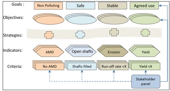
programs in Queensland as suggested in Figure 1.
To explore these issues, we review and critically analyse the current mining, rural development and
natural resource management literature in relation to two questions: 1) what role can input from
stakeholders and potential future land-users play in mine closure processes in Queensland? and 2)
what are the key characteristics of an appropriate model for engaging a stakeholder panel to play that
role? Our review focuses on coal mining in central Queensland, but is applicable to post-mining land-
use decision making in general. We conclude by proposing an alternative approach to postmining land
use decision-making based on a goal of “utility” and then describe three focus areas for future
research.
2Figure 1: Potential for stakeholder input under Guideline 18 (adapted from Minserve Group &
CQU, 2007 p. ii). Note AMD = Acid Mine Drainage
2. Opportunities from and barriers to incorporating mined land into a grazing property in
central Queensland
The potential benefits from incorporating post-mining lands into grazing properties relate to restoring
productive, social and aesthetic functions of the land as well as ecological ones. In some cases this
may mean returning the land to an alternative productive use once mining is completed (Harvey, 2016;
Unger, 2017). There is additional value in ensuring ongoing stewardship of parcels of disturbed land
that could otherwise become wildfire risks or pose challenges to control of weeds and pests
(Maczkowiack & Smith, 2012). Incorporating land into the surrounding land uses also minimises the
impact of closure on local character and the regional economy (Pavloudakis, Galetakis, & Roumpos,
2009).
Nevertheless, there are several challenges associated with incorporating mined land into grazing
properties. The major issue is that currently, there is no specific process for transferring mining lands
to agriculture and little guidance about what process and criteria to use for determining that such new
land uses are ‘acceptable’. While pasture-based revegetation is a common target for rehabilitation,
and, like bushland, a preferred subsequent land use among stakeholders in one survey (Maczkowiack
& Smith, 2012) the hierarchy of rehabilitation goals outlined by the Queensland regulator prioritises
environmental outcomes ahead of the social and economic dimensions of sustainability (Njeru, Kragt,
& Banning, 2015). Thus the bulk of attention of both companies and government is on defining and
meeting the environmental criteria.
There are also difficulties in quantifying and managing the residual risk associated with the potential
for rehabilitation to fail though eliminating all risk may be a long-term and near impossible task. It
appears inappropriate that residual risk should be assigned to future land owners, and the State
Government is unlikely to accept the transfer of large residual risks to the Crown/State. However,
there are opportunities for mechanisms to cover the residual risks and manage their incidence, such
as bond or insurance instruments, or tenure mechanisms and conditions that clearly specify any
responsibilities beyond those regarded as standard in a grazing enterprise.
3A third challenge is that mining companies may sometimes be discouraged from undertaking unclear
or unrewarding processes or be reluctant to seek land use change and relinquishment in case it
interferes with operations or they want to reopen the site in the future. Alternatively, they might get
certification and relinquishment, but keep exploration rights. In parallel there is the potential
reluctance of agricultural producers to take on post-mining land where remaining coal resources are
not sterilised and there may therefore be some risk of renewed mining interest in the sites.
The following sections outline evidence about how potential opportunities may be realised and the
challenges outlined above addressed to some extent by participatory approaches.
3. A role for input from stakeholders and grazing ‘experts’ in mine closure processes
Despite concerns about the capacity or responsibility of stakeholders in deliberations about complex
and uncertain situations such as satisfactory use of mined land, one survey of more than 200 cases of
stakeholder participation in making environmental and natural resource decisions demonstrated the
quality of such decisions and that the stakeholder groups have access to adequate scientific and
technical knowledge (Beierle, 2002).
Farming Systems Research similarly endorses landholder participation in rural land management that
is holistic and multidisciplinary (Norman, 2002). Such research may contain some lessons relevant to
the value and means of involving graziers and land users in management of post-mining lands. For
instance there is evidence that potential landholders may “assume some degree of risk so long as they
have control over the land and over decisions about what business to conduct on it and how to manage
it” (Milestad et al., 2012, p. 375 italics added). There are also indications that farmer participation in
multi-stakeholder initiatives ensures that land management options are acceptable from multiple
perspectives, not only from the perspective of productivity (de Krom, 2017). Additionally, stakeholder
input facilitates assessment of direct consequences of the choice of landuse on the potential future
farmers and of indirect consequences from the proposed economic activities, including on access to
public utilities and on amenity.
Changes in life-style and economic prosperity make the selection of a post-mining land use a complex,
multi-faceted decision requiring consideration of many factors associated with a viable future for
potential landusers and the affected community (Pavloudakis et al., 2009). Mine closure planning
needs to be consistent with wider understanding that “Systems should be tested with respect to their
ability to meet community goals” (Star, 2016: 243). Participatory approaches are argued to be
beneficial in both farming and mining contexts in developing relevant and acceptable principles and
practices based on local understanding of natural processes, available resources, farming systems and
planning regimes (Glass, Scott, & Price, 2013; Pavloudakis et al., 2009). Accordingly, Worrall, Neil,
Brereton and Mulligan (2009) suggest that management of post-mining land parcels should be attuned
to local context and “should ultimately be the responsibility of the relevant government agencies,
developed through a participative process with local stakeholders and private enterprise” (p. 1433).
Proposed future land uses may be, like farm management decisions and suitability to agricultural uses,
more readily evaluated with landholder participation in the formative stages as well as in the
evaluation of outcomes (Chataway, 2006; Norman, 2002). Future land use can be evaluated in terms
of the farmer’s financial situation, likely impacts on farm profitability, non-financial incentives and
costs involved, and alignment with the farmer’s current farming system, skill set and personal values
(Boardman, Bateman, & Seymour, 2017; Burton, 2004; Kragt et al., 2014; Morgan, Hine, Bhullar, & Loi,
2015; Page & Bellotti, 2015; Pannell et al., 2006). According to Roche (1999, p. 49), such stakeholders
“have a special position or experience that gives them unique insights... in this sense, what may be
4seen by others as 'anecdotal' becomes critical data because of the source's value". Despite
considerable variation and context-dependence (Knowler & Bradshaw, 2007), generally, rural
producers will adopt changes that perform well against these criteria and provide (or are perceived to
provide) private production benefits (Morgan et al., 2015; Page & Bellotti, 2015) or lifestyle benefits
(Burton, 2004).
The research shows that a complex mix of considerations is relevant to key decisions of rural producers
and the same would likely apply to decisions about the suitability of post-mining land to a grazing
enterprise with considerations proposed to include alternative values of utility, safety, beauty and
integrity (Harvey 2016). For example, the focus of rehabilitation in Europe is said to have become more
multi-functional – with attention to restoring productive functions as well as consideration of
ecological, aesthetic and social aspects of the landscape (Svobodova et al 2012; Unger, 2017).
Stakeholders need to evaluate options for land uses and identify potential management strategies to
avoid known rehabilitation risks while satisfying the productivity, efficiency and other criteria of
graziers. While environmental experts in mining companies can provide details of the likely landscape
and site conditions, local graziers will be the prime source of details of grazing systems and practices
and both groups can pool their knowledge with scientists from various disciplines to identify key
opportunities and threats with respect to long term production and sustainability. There are a number
of different domains of an ex-mine site (such as pit, tailings, spoil heaps, revegetated areas, off-set
zones and locations of decommissioned infrastructure). They pose varying degrees of risk and would
likely be considered separately when considering post-mining land use (Doley & Audet, 2013; Grigg et
al., 2006). Not all of these domains may be suitable for grazing, and the suggestion is that graziers
may be best positioned to assess that and explain their reasons.
Greater community engagement is actually endorsed in current mine relinquishment requirements
and processes. For instance Queensland’s guideline on Rehabilitation requirements for mining
resource activities states that,
[Completion criteria] 1 should be developed in consultation with stakeholders (e.g. the
landowner, local government, indigenous groups, community groups and various State
departments). The criteria are of importance to landowners because they may set limitations
on the agreed future land use and expose the landholder to risks and potential costs
associated with maintaining the former mine site in a safe and productive condition
(Department of Environment and Heritage Protection, 2014, p. 18).
Certification and relinquishment come late in the mine life-cycle, however input from stakeholders is
advocated from early in the life of mine,
The expectation created by mining legislation, self-regulation statements and guidelines is for
early, transparent stakeholder engagement, detailed closure planning at feasibility stage,
exemplary environmental practices and performance reporting during the operational phase,
and that land disturbed by mining will be progressively returned to a useable postmining
condition, of a similar or better land-use than existed prior to mining (White et al., 2012, p.
67).
1
Completion criteria “provide a clear definition of successful rehabilitation for each domain at the mine site in
the form of a set of measurable benchmarks against which the rehabilitation indicators can be compared to
determine whether the objectives are being met.” (DEHP, 2014, p. 17)
5Table 1: Roles of regulator, mining company and potentially stakeholders in the mine
rehabilitation process (Modified from DEHP 2014: 7)
Regulator Mining company Potential Questions/problem to
(DEHP/DNRM) stakeholder collaboratively solve
engagement
Pre-mining
Exploration and Identify acceptable What land use/ mosaic of
feasibility studies – future land uses – land uses would be
including baseline whether pre-mining, acceptable/ appropriate on
studies and natural or novel this mining lease area once
planning of possible ecosystem/ land use. mining has finished?
rehab objectives Signal what factors What factors do you take
they consider in into consideration to
calculating the value determine suitability of
proposition and land to grazing? – (e.g., site
identify requirements conditions and
to make land suitable characteristics?
for end use/s (i.e. to Financial viability/ business
make land safe, stable considerations?
and non-polluting for Personal values and
those uses and meet circumstances?
other functional External conditions
requirements e.g. (markets, drought etc)?
viability, lifestyle etc) - Proposed indicators of land
i.e. propose being suitable, safe, stable
completion criteria for and non-polluting for the
goal 4. (These would multiple functions
not override the envisaged and to meet
ecological criteria but other functional
may add new requirements?
information e.g. about
(i) acceptable residual
risk (ii) acceptable
trade-offs and
balances or (iii) whole-
of-enterprise/
landscape assessment
versus isolated
domains.
Pre-design Participation of What completion criteria
conference stakeholders - as (standards re the
orientation so they are indicators) would you apply
informed of options to say ‘a grazing
being considered and proposition’?
can provide ‘insider’ Acceptable levels of
perspective on those residual risk?
EIA requirement Prepare EIS and/or Closely engaged in What are the possible
decision application for site- preparation of EIS impacts and what is their
specific EA for a including social impact significance?
prescribed ERA assessment (SIA) and
6(environmentally in mine planning and What level of risk
relevant activity) risk assessments. (likelihood and
consequences) is
associated with mining
activities?
What are the pros and cons
of various mitigation
options?
Prepare draft Do stakeholders have any
Environmental objection or suggest any
Authority (EA) conditions to feed in during
Objection hearing if statutory public
required consultation periods?
Issue EA – including
conditions re rehab
During mining
Progressive rehab Participation in Are targets and conditions
and monitoring monitoring and being met?
adaptive management
of rehab.
Apply for Endorsing ‘readiness’ to be
progressive (partially) certified (by their
certification standards for goal 4) as one
perspective for authorities
to consider. Also input
about acceptability of
residual risk
Assess progressive
rehab report
Decide the
application
Adjust financial
assurance
Post-Mining
Apply for surrender Is specialist expertise about
of EA – including Contribute to likely risks advisable (if so,
final rehab report consensus on what sort?)
and residual risk acceptable residual
calculation risk or areas where
more science is
needed
Assess final rehab Potentially involved Are any long-term
report (PRAC) through covenants, management
land access arrangements needed and
Decision on Lodge any residual agreements etc how would they work for
application risk payment future landholders and
Post closure neighbours?
management (if
required)
74. A panel model for engaging stakeholders in planning post-mining land uses
The widespread endorsement of participatory approaches and stakeholder engagement in closure
planning does not mean there is consensus about effective ways of doing that. In other fields such as
Natural resource management and urban planning, approaches include citizen’s juries, reference
panels, stakeholder advisory committees, world cafés, deliberative polls, focus groups, field days,
surveys, Delphi rounds, choice experiments, action research and participatory monitoring
(ÁlvarezFarizo, Gil, & Howard, 2009; Bell, Morse, & Shah, 2012; Carson & Gelber, 2001; Harding &
Macdonald, 2001; Renn, 2006; Solomon, 1999; Strand, Carson, Navrud, Ortiz-Bobea, & Vincent, 2017).
Rauschmayer and Risse (2005) propose that the choice of an appropriate participatory approach
should be based, on consideration of their information management, legitimacy, social dynamics and
costs. An alternative set of criteria are scope, representativeness, timing, comfort and convenience,
and influence (Eiter & Vik, 2015). The existence of different criteria is a recognition that participatory
approaches offer differing opportunities for incorporating diverse and equally valuable perspectives,
co-producing knowledge and ideas, generating dialogue and fostering an open and positive future-
focus.
In this section we outline and provide a rationale for one structured model of participatory planning
highlighting the key qualities of such an approach suited to engaging stakeholders in the context of
post-mine planning. We do not aim to provide a comprehensive review of participatory techniques
(for reviews see Rauschmayer & Risse, 2005; Reed, 2008; Rowe & Frewer, 2005; Warburton, 1997;
Webler, 1999). Nor are we comparing or evaluating models of participatory processes (for approaches
to comparative evaluations see Eiter & Vik, 2015; Hassenforder, Smajgl, & Ward, 2015). Here we build
on the findings of other researchers to specifically identify an approach that seems appropriate for
the mining context concentrating on the dimensions of who to engage and how in a process that may
extend over years, even decades, and will involve potentially conflicting judgements of economic
opportunity, risk and responsibility.
A stakeholder panel is an established means of natural resource management and catchment
management that involve group deliberation of relevant factors from various perspectives and
identification of potential areas of conflict and of consensus. We suggest that a stakeholder panel (or
participatory advisory committee or reference group) is a useful and appropriate approach for
participatory decision-making about agreed land uses in the mining rehabilitation context. While there
are limited examples in the mining context (Minserve Group & CQU, 2007; Owen & Middlin, 2010), in
other settings, such a panel is often advocated as a robust strategy for managing shared land since it
provides a forum for managing risk and supporting stakeholder assessments, analysis and decision-
making as a basis of adaptive management in dynamic and uncertain situations where questions of
sustainability are an issue (Doelle & Sinclair, 2006; Glass et al., 2013; Leys & Vanclay, 2011). A
stakeholder panel, which involves a limited number of participants, is particularly appropriate in the
context of planning in central Queensland where the number of potential landholders and viewpoints
are fewer than for other decision making contexts such as regional planning or developments in urban
areas. Stakeholder panels can participate in a process of adaptive interaction and decision making at
intervals throughout the mine life-cycle. The panels would involve different roles for the regulator,
proponent, graziers and other stakeholders with some of the challenges at each stage collaboratively
tackled to ensure effective and lasting strategies. Table 1 proposes the role stakeholders could play at
various points throughout the mine life cycle to complement the roles and responsibilities of the
relevant state government departments and mining companies and provides samples of questions
relevant to all parties.
8The composition, structure and modus operandi of panels suited to rural change vary considerably. As
one example, for rural producers, Chataway (2006) outlines a process of identifying ‘hosts’ of primary
study sites and then using existing industry discussion groups, of which the host landholders were
members, as reference groups. In the case of mine rehabilitation the appropriate ‘hosts’ would be
underlying landowners and neighbours, with industry groups such as the Queensland Farmers’
Federation and Agforce, or resource groups like Landcare, or Catchment Associations potentially
acting as the reference groups. This would allow consideration of different scales of interest – both
localised, regional and statewide. Other examples are commonly used for regional and landscape level
planning notably multi-sectoral committees and community management boards (Eberhard,
Johnston, & Everingham, 2013; Kellert, Mehta , Ebbin, & Lichtenfeld, 2000; Robins & Dovers, 2007).
As well as considering different forms, scales and functions, it is also valuable for group decision
processes to include strategies to focus the discovery, dialogue and decision making and to bridge
boundaries between the different perspectives of the ecologist, mine technical experts, regulators
and various community stakeholders. Each of these stakeholder groups has its own body of
knowledge, values, priorities and standards which often result in apparently incompatible positions.
Arguably a key purpose for engaging different perspectives will be to explicitly address the lack of
certainty about some issues such as the residual risks associated with mined land. Groups who
participate in the stakeholder panel need to draw on diverse forms of knowledge and be able to
understand not only basic biophysical data but also the drivers and barriers affecting land managers
and the impacts of land management practices on key regional assets and ecosystems (Byron & Lesslie,
2008).
For a stakeholder advisory panel working on rehabilitation and closure planning at a landscape level,
to “incorporat[e] different viewpoints in a fair and flexible manner” (Star, 2016, p. 246) requires
holistic consideration of multiple interlocking social, economic and ecological systems involving a
range of stakeholders. Each stakeholder group has a “local view that includes information about only
a subset of the tasks” (Star, 2016, p. 246). Participatory approaches for choosing post-mining
landscapes assume that stakeholders are well-positioned to define the varied challenges and
opportunities they face and that they have the capacity to respond effectively to their own life
circumstances. These may not always reveal conflicting interests. Collier (2011) demonstrated that
stakeholder engagement in open planning and decision-making without prior prescriptions, brought
stakeholders to a desire for multiple land uses and similar rehabilitation conclusions and goals as
ecological practitioners, academics, and NGOs.
An advantage of group situations is that they facilitate stakeholders’ learning from one another and
provide the basis for understanding of landscape-scale effects and intersections with policy decisions.
Rather than top-down application of formulaic regional development strategies, these situations rely
on “learning the specifics of a particular setting and enabling participants to learn from their own
experience and that of others” (Ostrom, 2005, p. 275). Considering the perceptions of groups of
stakeholders in aggregate is appropriate because landholders are not isolated decisionmakers and the
role of collective processes and group dynamics in farm management choices should be recognised
and incorporated into engagement processes (Milestad et al., 2012). Group settings stimulate greater
reflexivity and allow participants to explain and qualify their responses or identify important
contingencies associated with their answers – important elements of exploring hypothetical scenarios
or projecting the future (Stewart, Shamdasani, & Rook, 2007).
Although stakeholders may seek out additional expertise and technical information, deliberative
decision making amongst the stakeholder panel is most productive if it happens in a dialogical and
9interactive way and the stakeholders are empowered. Rather than information being obtained from
various parties as the basis for separate synthesis or ‘ajudication’ by ‘experts’ about the best solution
or trade-off, knowledge and understanding are co-produced by engaged parties with the assistance
of facilitators. The facilitators “open up spaces for dialogue between these contrasting modes of
knowledge construction built upon different life experiences, expectations and identities” (Long &
Beierle, 1999, p. 19). Menconi, Grohmann and Mancinelli (2017) conducted a systematic review of
participatory processes involving farmers. They identified both strengths and weaknesses in the
involvement of farmers in decision-making, for example, often in such processes farmers were
engaged only as a source of information rather than as active participants in the choices for the
protection, management and transformation of the rural territory. Thus genuine empowerment
through a deliberative process, especially of potential future landholders, is consistent with the
general literature about agricultural innovation, sustainable farming systems and responsible land use
management which designates the role of the landholder as crucial to successful farm management
(Grigg et al., 2006; Milestad et al., 2012). Such an approach also recognises Australian farming as a
multifunctional management exercise with production, consumption and protection objectives.
Graziers are those who routinely manage central Queensland's rural spaces but opportunities for them
to collaborate with those making decisions about the transformation of these territories after mining
have been limited.
5.Tools and techniques to focus and facilitate stakeholder panel decision-making
This section identifies from the literature specific techniques that may assist and add value to
stakeholder panel deliberations drawing on the considerable interest in developing tools and
techniques to focus and facilitate the participatory decision-making including the use of visual
prompts, spatial representations, GIS visualisation methods and interactive modelling (de Groot,
Alkemade, Braat, Hein, & Willemen, 2010; Minserve Group & Central Queensland University, 2007;
Owen & Middlin, 2010; Svobodova, Sklenicka, & Vojar, 2015; Voinov & Bousquet, 2010). Such methods
are particularly useful for mining landscapes where the dramatic changes to the landscape may be
hard to visualise without aids. Research about some of these and their application to mining
landscapes is outlined in this section.
Research evidence suggests there is potential for interdisciplinary groups and stakeholders with
different areas of expertise to cooperate successfully despite having different goals, time horizons and
methods of working with data and not fully understanding the models of others (Star, 2016). The
success of such efforts is facilitated by the development of bridging social capital if very disparate
social groups are involved (de Krom, 2017) and by the use of what has been called a “boundary object”
(Star, 2016). An abstracted map is a prime example of a boundary object to be a hypothetical but
authentic representation for all parties to communicate and cooperate over tackling a multifaceted
task (Star, 2016).
The use of GIS, mapping and visual representations have potential for engaging landholders (Minserve
Group, 2007; Owen & Middlin, 2010). These tools facilitate realistic consideration of landholding-scale
sites and can lead to better understandings of relationships among topography, ecosystems,
economics and other dimensions (Andrews, McMullen, & Grimshaw, 2007; Teutsch, Collins, & Ditsch,
1999). Spatial tools allow rural land use decisions to be attuned to a particular landscape context as
well as based on the specific needs of the agricultural sector and the socioeconomic and
environmental consequences (Tassinari, Torreggiani, & Benni, 2013). Spatial mapping, for example, is
a powerful tool for understanding the socio-cultural realities of landscapes and ecosystems. It enables
10the localization of potential conflict areas and the representation of multiple dimensions including
intangible ones that may not readily be quantified.
Visual representations have been used in some stakeholder group contexts as suitable analytical and
design tools and techniques to aid decision-making and identify preferences and perceptions. Visual
indicators can give strong representation of a range of physical, chemical and biological properties and
conditions that are readily assessed by the practised eye (Tongway & Hindley, 2004). Various tools
appropriate to land use change decisions combining ecosystems and restoration targets have been
researched (see de Groot et al., 2010 for an overview). For instance, Byron and Lesslie (2008) report
using GIS to integrate remotely sensed information, land parcel boundary information, forest and
reserve mapping, land cover, and local government zoning with data from a social survey of
landholders about their values, perceptions and practices. This demonstrates the potential of spatial
methodologies to provide material to aid group deliberations. Other researchers have compared
qualitative assessments of biophysical and socioeconomic parameters obtained in focus groups of
local stakeholders with resource management categories and decisions based purely on GIS data
(Mehra, Singh, Abrol, & Oinam, 2017). Though this research did not advocate synthesis of different
data it provides an assurance of the authenticity of the GIS representations. Visual landscape
preferences and judgements on the basis of realistic configurations of visual clues and attributes are
established techniques in some planning situations (Svobodova, Sklenicka, Molnarova, & Salek, 2012).
Typical attributes of a post-mining landscape can be identified and used in an assessment of post-
mining options as demonstrated by Svobodova and colleagues (2012). They found seven variables
were significant to acceptance of mining land rehabilitated to agricultural or forestry uses to restore
productive functions.
Along with static GIS maps, time-series land use mapping at various scales can be developed using
diverse information sources to track significant trajectories in land use change and understand the
interaction of variables. It also allows comparisons of different scenarios and improves transparency
about trade-offs and costs as well as integration of local knowledge (Ungaro, Häfner, Zasada, & Piorr,
2016). One suggestion in this vein is representing a small number of alternatives spatially, with maps
or photographs as shared information to stimulate dialogue among a range of viewpoints. This is seen
as appropriate for multi-dimensional decisions especially ones that can have wider public good
implications and also to “induce participants to assume a longer-term and more socially-oriented
position” (Bunse, Rendon, & Luque, 2015, p. 90).
Multi-criteria analysis in combination with GIS mapping is a common analytical decision making
approach to reach agreement about different land use planning decisions. Logan, Murphy and Beale
(2007), describe a hybrid assessment technique based on multi-criteria analysis, risk analysis and cost-
benefit analysis in which alternative closure configurations are scored on an integrated set of weighted
criteria. They suggest the advantages of the technique are its ability to be customdesigned to
accommodate meaningful environmental, social and economic criteria and the userfriendliness that
facilitates the engagement of stakeholders. Applications of the multi-criteria approach to particular
sites in central Queensland have been described by Grimshaw (2007) and Welsh, Bianco and Roe
(2007). Other techniques that show promise are using “spatial units” to support syntheses of land-
use, economic, agricultural, and landscape planning (Tassinari et al., 2013) and employing a
hypothetical grazing land management scenario to explore, through choice modelling, graziers’
reasons for and the costs of particular patterns of decision making on rangeland properties (Gregg &
Rolfe, 2016) as well as game-style challenges under various scenarios (Lamarque et al., 2013). The
importance of assessment methods involving economic aspects besides physical, agronomic, and
ecological ones is being increasingly advocated in rural land-use planning (Tassinari et al., 2013). The
11inclusion of the economic criterion is appropriate since efficiency is a key priority for graziers.
However, producers may have multiple values in addition to the profit-maximising criterion especially
when they are confronted with considerable uncertainty and constantly changing circumstances. For
farm managers to achieve higher enterprise and environmental efficiency the limits and associated
costs need to be understood (Gregg & Rolfe, 2016).
This body of research points to the use of a visual ‘boundary object’ to facilitate stakeholder
deliberations given many of the characteristics of the challenges involved in considering post-mining
land uses. Stakeholders must come to practical conclusions about hypothetical and hard-to-visualise
landscapes that require economic, social and environmental considerations in the public interest as
well as self-interest. In such situations, presenting stakeholder groups with a realistic post-mining
landscape can stimulate dialogue and elicit people’s experiences, values and preferences.
6. An alternative approach to post-mining land use decision-making based on utility
Unclear and unformulated approaches to rehabilitation and mine closure in central Queensland pose
environmental risks and economic burdens for mining companies, government and the pastoral
industry (Fourie & Brent, 2006). The uncertainty prevailing in this jurisdiction contrasts with other coal
mining regions where more guidance is provided (for example the USA see Skousen & Zipper, 2014).
To propose a pathway to more functional outcomes, this paper has focussed on exploring the potential
for stakeholder input with regard to one of the four sustainability goals of mine rehabilitation and
closure as specified under Guideline 18 in Queensland – “Agreed beneficial land use” (Department of
Environment and Heritage Protection, 2014). Rather than the various rehabilitation goals being
achieved sequentially they are presumed to be iterative. Stakeholders input is represented in Figure
1 as being primarily related to the fourth goal of agreed land use (solid line), however, it will influence
deliberation on other goals since they affect agricultural management (dashed line). Agreed beneficial
land use has not received the systematic attention that has been directed at the other three goals –
safe, stable and non-polluting landscapes. If rehabilitated landscapes are designed and implemented
to optimise post-mining utility and with guidance and agreement of stakeholders to prevent poor
decisions early in a mine’s life, long-lasting negative legacies may be avoided. This paper proposes an
approach to decision-making about postmining land uses – or utility – on the basis of its exploration
of two questions.
First it concludes that most of what is known about the opportunities and risks of grazing as a
postmining land use in central Queensland’s Bowen Basin is based on techno-scientific knowledge –
notably crucial environmental science about the success factors in rehabilitating to pasture and
impacts of grazing on the stability, safety and non-polluting status of land rehabilitated to pasture.
However only a handful of studies have considered the opportunities and risks from the perspective
of potential future land users and the issues they consider in determining long-term utility of a
property. This leaves a major gap in knowledge about production, consumption and protection goals
of stakeholders and the critical factors in land management decisions by graziers that affect
communities’ well-being. The proposition therefore is for stakeholder participation in establishing
rehabilitation plans and post-mining land uses.
There are different views about the status of input from stakeholders and potential future land users
in formal mine closure processes, and no clear demonstration of how that input on one of the four
closure goals would be balanced with scientific and technical understandings in decision-making. A
second proposition in the paper is for a collaborative process based on greater understanding of the
factors influential in decisions of the wider group of stakeholders. This perspective could inform
closure processes and improve confidence in some options. For instance, understanding of land uses
12that would be deemed acceptable/ appropriate on mining leases once mining has finished and the
factors that stakeholders take into consideration to determine suitability of land to grazing may be of
value to proponents in planning their rehabilitation practices and also to regulators in considering
whether rehabilitation outcomes satisfactorily maximise residual opportunities of post-mining land
and minimise the risks (to the land, the miner, the pastoralist and the Queensland public interest/
government). In line with this, Table 1 suggests potential roles for stakeholders alongside those of
proponents and regulators throughout the mine life-cycle and regulatory process. This sort of
collaborative governance of multi-dimensional land use changes allows for consideration of the
interdependence of environmental, social and economic factors and is emerging in many contexts
(Banzhaf et al., 2017).
Third, the review suggests that an appropriate model for engaging and empowering a stakeholder
panel to play that role would have the following characteristics:
a. Ideally meaningful engagement of stakeholders would begin early and continue at intervals
throughout operations and the rehabilitation and closure processes. This would allow for
adaptive management and community preferences and considerations of utility to be built
in alongside consideration of more technical and scientific constraints and objectives.
b. The stakeholders involved should be a cross-section of predominantly local people who are
potentially affected in some way by closure and by decisions about future land use notably
graziers as potential future land-users as well as other ‘experts’.
c. The question/ challenge or task set for this group should be very open so as not to constrain
innovation and the synergies of harnessing multiple resources and diverse experience and
perspectives.
d. Group deliberations focused on an authentic case and with the ability to draw upon a range
of expertise should play a major part in the process.
To a large extent that leaves unanswered the question of how decisions reached in such groups and
by such processes would be integrated with current evidence and decisions weighed in progressive
certification and mine closure processes. Those issues of combining ecosystem, economic and social
functions holistically are matters that decision makers and standard setters will need to determine,
and a pilot or ‘virtual’ demonstration of what could be achieved through a process such as that
outlined above could suggests options for aligning the regulation of rehabilitation and closure with
the public interest and the interests of potential future landusers.
References
Alves-Pinto, H. N., Latawiec, A. E., Strassburg, B. B. N., Barros, F. S. M., Sansevero, J. B. B., Iribarrem,
A., . . . Silva, A. C. P. (2017). Reconciling rural development and ecological restoration:
Strategies and policy recommendations for the Brazilian Atlantic Forest. Land Use Policy, 60,
419-426. doi:http://dx.doi.org/10.1016/j.landusepol.2016.08.004
Andrews, M., McMullen, A., & Grimshaw, S. (2007). GIS-Based 3-D Analysis and Visualisation Tools –
An Example in Advanced Planning for Mine Closure, Hunter Valley, Australia. Paper
presented at the Second international seminar on mine closure, Santiago, Chile.
Banzhaf, E., Kabisch, S., Knapp, S., Rink, D., Wolff, M., & Kindler, A. (2017). Integrated research on
land-use changes in the face of urban transformations – An analytic framework for further
studies. Land Use Policy, 60, 403-407.
doi:http://dx.doi.org/10.1016/j.landusepol.2016.11.012
13Baumgartl, T., & Glenn, V. (2013). Returning productivity of Australian prime agricultural land after
mining: how international experiences in rehabilitation may show the way forward. AusIMM
Sustainability News, 2, 6-8.
Beierle, T. C. (2002). The Quality of Stakeholder‐Based Decisions. Risk Analysis, 22(4), 739-749.
doi:10.1111/0272-4332.00065
Bell, S., Morse, S., & Shah, R. A. (2012). Understanding stakeholder participation in research as part
of sustainable development. Journal of Environmental Management, 101, 13-22.
doi:http://dx.doi.org/10.1016/j.jenvman.2012.02.004
Boardman, J., Bateman, S., & Seymour, S. (2017). Understanding the influence of farmer motivations
on changes to soil erosion risk on sites of former serious erosion in the South Downs
National Park, UK. Land Use Policy, 60, 298-312.
doi:http://dx.doi.org/10.1016/j.landusepol.2016.10.043
Bunse, L., Rendon, O., & Luque, S. (2015). What can deliberative approaches bring to the monetary
valuation of ecosystem services? A literature review. Ecosystem Services, 14(Aug), 88-97.
doi:http://dx.doi.org/10.1016/j.ecoser.2015.05.004
Burton, R. J. F. (2004). Seeing Through the ‘Good Farmer's’ Eyes: Towards Developing an
Understanding of the Social Symbolic Value of ‘Productivist’ Behaviour. Sociologia Ruralis,
44(2), 195-215. doi:10.1111/j.1467-9523.2004.00270.x
Byron, I., & Lesslie, R. (2008). Spatial Methodologies for Integrating Social and Biophysical Data at a
Regional or Catchment Scale. In R. J. Aspinall & M. J. Hill (Eds.), Land Use Change: Science,
Policy and Management (pp. 43-61). Boca Raton: CRC Press.
Carson, L., & Gelber, K. (2001). Ideas for Community Consultation: A discussion on principles and
procedures for making consultation work. Deprtment of Urban Affiars and Planning , NSW.
Retrieved 18 May 2017 from
http://www.activedemocracy.net/articles/principles_procedures_final.pdf
Chataway, R. (2006, March). The role of farmer participants in developing practices that better
sustain the soil resource base on cropping based dairy farms in southern Queensland. Paper
presented at the Asia Pacific Extension Network 2006 National Forum. Beechworth, Victoria.
Collier, M. J. (2011). Incorporating Socio-economic Factors into Restoration: Implications from
Industrially Harvested Peatlands. Restoration Ecology, 19(5), 559-563. doi:10.1111/j.1526-
100X.2011.00794.x
de Groot, R. S., Alkemade, R., Braat, L., Hein, L., & Willemen, L. (2010). Challenges in integrating the
concept of ecosystem services and values in landscape planning, management and decision
making. Ecological Complexity, 7(3), 260-272.
doi:http://dx.doi.org/10.1016/j.ecocom.2009.10.006
de Krom, M. P. M. M. (2017). Farmer participation in agri-environmental schemes: Regionalisation
and the role of bridging social capital. Land Use Policy, 60, 352-361.
doi:http://dx.doi.org/10.1016/j.landusepol.2016.10.026
DEHP (Department of Environment and Heritage Protection). (2014). Guideline. Resource Activities:
Rehabilitation requirements for mining resource activities (EM1122). Brisbane: Queensland
Government Retrieved 6 March 2017 from
https://www.ehp.qld.gov.au/assets/documents/regulation/rs-gl-
rehabilitationrequirements-mining.pdf.
Doelle, M., & Sinclair, A. J. (2006). Time for a new approach to public participation in EA: Promoting
cooperation and consensus for sustainability. Environmental Impact Assessment Review,
26(2), 185-205. doi:10.1016/j.eiar.2005.07.013
Doley, D., & Audet, P. (2013). Adopting novel ecosystems as suitable rehabilitation alternatives for
former mine sites. Ecological Processes, 2(1), 1-11. doi:10.1186/2192-1709-2-22
14You can also read