ENHANCING RUNOFF AND DRAINAGE MANAGEMENT IN THE FRASER VALLEY AGRICULTURAL SECTOR - Climate Action Initiative
←
→
Page content transcription
If your browser does not render page correctly, please read the page content below
Fraser Valley Climate Adaptive Drainage Management Forum

ENHANCING RUNOFF AND DRAINAGE MANAGEMENT IN THE
        FRASER VALLEY AGRICULTURAL SECTOR

                                      Final Report

                                          Prepared For

 The BC Blueberry Council in partnership with the BC Agriculture & Food Climate Action Initiative

                                          Prepared By

                                       in association with:
Fraser Valley Climate Adaptive Drainage Management Forum

STATEMENT OF LIMITATIONS
This report has been prepared by Tim Wilson and Eco-Logical Resolutions for the exclusive use and
benefit of the BC Agriculture & Food Climate Action Initiative (CAI), the Fraser Valley Agricultural
Adaptation Working Group and project partners. This document represents the best judgement of Tim
Wilson and Eco-Logical Resolutions, based on the information available at the time of its completion,
and as appropriate for the scope of work. Services were performed according to normal professional
standards in a similar context and for a similar scope of work.

ACKNOWLEDGEMENTS
The Fraser Valley Climate Adaptive Drainage Management Forum project was directed by a Project
Management Committee (PMC) selected from the Fraser Valley Agricultural Adaptation Working Group.
PMC members include:

Alison Stewart            Manager of Strategic Planning, Fraser Valley Regional District
Allen James               Sweetbriar Poultry Farm, Chilliwack | BC Agriculture Council and BC Poultry
                          Association Board Member | CAI Chair
Chris Zabek               Regional Agrologist, Ministry of Agriculture
David Trotter             Agroforesty Specialist, Sector Development Branch, Ministry of Agriculture
Emily MacNair             Manager, Adaptation Programming, Climate Action Initiative
Holger Schwichtenberg     Holberg Farm, Kent | BC Dairy Association and Mainland Milk producers | CAI
                          Board Member
Jason Smith               Fraser Berry Farms, Matsqui Prairie | PIER Management and Consulting| BC
                          Blueberry Council |CAI Board Member
Kyle St Amour             Drainage Technician, Engineering Department, City of Chilliwack
Matthew Connolly          Environmental and Engineering Services Coordinator, District of Kent
Mike Firlotte             Acting Director of Utility Operations | Manager, Dyking, Drainage, and
                          Irrigation Committee, City of Abbotsford
Samantha Charlton         Project Coordinator, Adaptation Programming, Climate Action Initiative
Stephanie Tam             Water Management Engineer, Drainage, Ministry of Agriculture

Dru Yates of ES Cropconsult Ltd. provided outreach and logistical support to the project. Emily MacNair
and Samantha Charlton provided valuable feedback on all materials produced as part of the Project.

The Pacific Climate Impacts Consortium conducted climate modelling, analysis, and data interpretation,
and reviewed explanatory text within the report.

Research into innovative runoff and drainage management strategies benefited from interviews with
the following topic experts who graciously provided their time and perspectives:

Chris Elder               Long Range Planner, Whatcom County Planning & Development Services
David Trotter             Agroforesty, Sector Development Branch, Ministry of Agriculture
Dr. David Lapen           Research Scientist, Ottawa Research Centre, Agriculture and Agri-Food
                          Canada
Dr. Sean Smukler          Assistant Professor, Applied Biology & Soil Science, Faculty of Land and Food
Fraser Valley Climate Adaptive Drainage Management Forum

                           Systems, UBC
Gé van den Eertwegh        KnowH2O, Netherlands
Harold B. Rudy             Executive Officer, Research and Business Development, Ontario Soil and Crop
                           Improvement Association
Holger Schwichtenberg      Holberg Farm, Kent | BC Dairy Association and Mainland Milk producers | CAI
                           Board Member
Jason Smith                Fraser Berry Farms, Matsqui Prairie | PIER Management and Consulting| BC
                           Blueberry Council |CAI Board Member
Kyle St Amour              Drainage Technician, Engineering Department, City of Chilliwack
Matthew Connolly           Environmental and Engineering Services Coordinator, District of Kent
Mike Firlotte              Acting Director of Utility Operations and Manager, Dyking, Drainage, and
                           Irrigation Committee, City of Abbotsford
Mike Younie                Deputy Chief Administrative Officer, District of Mission
Scott Barrett              Director, Resource Management - South Coast, BC Forests, Lands, Natural
                           Resources and Rural Development
Stephanie Tam              Water Management Engineer, Drainage, Ministry of Agriculture
Sterling Chan              Manager of Engineering and Infrastructure, Fraser Valley Regional District
Ted van der Gulik          President, Partnership for Water Sustainability in British Columbia

The Forum benefited from presentations given by the following guest speakers:

Chris Elder                Long Range Planner, Whatcom County Planning and Development Services
Jennifer Prive             Professional Biologist, Environmental Dynamics Inc.
Ted van der Gulik          President, Partnership for Water Sustainability in British Columbia
Trevor Murdock             Climate Scientist, Pacific Climate Impacts Consortium

The authors are additionally grateful to Forum participants who shared their expertise and perspectives
during group discussion and deliberation.

PROJECT FUNDING

Funding for this project has been provided by the Governments of Canada and British Columbia
through the Investment Agriculture Foundation of BC under Growing Forward 2, a federal-provincial-
territorial initiative. The program is delivered by the BC Agriculture & Food Climate Action Initiative.
The Governments of Canada and British Columbia are committed to working with industry partners.
Opinions expressed in this document are those of Tim Wilson and Eco-Logical Resolutions and not
necessarily those of the Governments of Canada or British Columbia, the Investment Agriculture
Foundation or the B.C. Agricultural Research Development Corporation.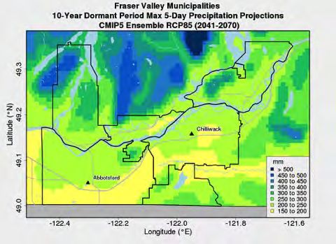
Fraser Valley Climate Adaptive Drainage Management Forum

LIST OF ACRONYMS
ARDSA     Agricultural and Rural Development Subsidiary Agreement
BCUC      BC Utilities Commission
BMP       Best management practice
CAI       BC Agriculture & Food Climate Action Initiative
CREP      Conservation Reserve Enhancement Program
CTD       Controlled tile drainage
DDI       Dyking, Drainage, and Irrigation Committee
DFO       Department of Fisheries and Oceans (or Fisheries and Oceans Canada)
DID       Drainage Improvement District
DMP       Drainage Management Plan
ECCC      Environment & Climate Change Canada
ESI       Ecological Service Initiative
FLNRORD   BC Ministry of Forests, Lands, Natural Resource Operations and Rural Development
FRISP     Farmland-Riparian Interface Stewardship Program
FVRD      Fraser Valley Regional District
GCM       Global Climate Model
IAFBC     Investment Agriculture Foundation of British Columbia
IPCC      Intergovernmental Panel on Climate Change
ISMP      Integrated Stormwater Management Plan
MAG       BC Ministry of Agriculture
NGO       Non-Governmental Organization
PCIC      Pacific Climate Impacts Consortium
QEP       Qualified Environmental Professional
RCP8.5    Representative Concentration Pathway 8.5
ROI       Return on Investment
WID       Watershed Improvement District
Fraser Valley Climate Adaptive Drainage Management Forum

EXECUTIVE SUMMARY
The Fraser Valley Climate Adaptive Drainage Management Forum project was initiated to generate and
share the best available precipitation projections for the Fraser Valley; research collaborative climate
adaptive drainage management strategies adopted in comparable settings; and host a Forum between
producers, local government and agency staff, researchers and agricultural association representatives
to deliberate preferred drainage management strategies to address local runoff and drainage
challenges.

Implications of climate change for drainage management
Drainage remains one of the primary limiting criteria for agricultural production in the Fraser Valley, yet
changing climate and additional drainage demands are reducing the effectiveness of existing drainage
infrastructure. The climate projections indicate that changes in Fraser Valley precipitation patterns will
considerably increase the agricultural drainage burden. Compared to past climate (1971 – 2000) in the
region, average values for the following precipitation indicators are projected to increase by ~2050 as
follows:

    •   Compared to the rest of the year, increases in total precipitation and maximum storm
        precipitation amounts will be largest during Spring (March, April, May) and Fall (September,
        October, December) when field trafficability is particularly important.
    •   The precipitation amount for the ARDSA growing season extreme design storm is projected to
        increase by about 20%, although in any given year it could increase by 40% or more.
    •   The precipitation amount for the ARDSA dormant season extreme design storm is projected to
        increase by about 10%, although in any given year it could increase by 20% or more.
    •   Considerably more precipitation (about 20%) is expected to fall during extremely wet days (1-in-
        20 wettest day) in the future. Expressed differently, extremely wet days that used to occur once
        every 20 years are projected to occur once every 10 years.
    •   The wettest periods in the region are projected to become even wetter (by about 35%), and the
        wettest days of the year are projected to occur more closely together.
Given these projections, and with parts of the region already not meeting the ARDSA criteria (KWL,
2017), the probability of increased crop losses and localized flooding is likely to rise without
incremental intervention and investment in improved drainage management and infrastructure.

Preferred drainage management strategies

Deliberation amongst participants of the Forum workshop revealed broad support and preference for
pursuing producer-led drainage area management planning; and improving drainage management and
maintenance knowledge and capacity. Potential action items arising from the Forum include:

Action 1. Pilot development of drainage area management planning

Action 1a: Create producer-led agricultural drainage planning group.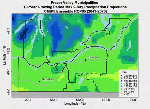
Fraser Valley Climate Adaptive Drainage Management Forum

Action 1b: Inventory, characterize and assess a pilot drainage area including identification of drainage
           (and irrigation) enhancement opportunities.

Action 1c: Pilot a multi-stakeholder, multi-objective drainage area planning process, with the intention
           of embedding individual actions within a broader plan and securing funding for upgrades.

Action 2:   Improve drainage management and maintenance knowledge and capacity

Action 2a: Establish an online, map-based decision support tool to support watercourse permit
           applications and the selection and application of watercourse management and
           maintenance Best Management Practices.

Action 2b: Increase the professional support available to producers through improved access to
           qualified professionals (create new training opportunities and prequalification and
           promotion options for trained individuals).

Action 2c: Improve knowledge transfer to producers, potentially through a liaison role, via workshops,
           field days and streamlined information for/to producers.
Several agency staff felt that updating watercourse classifications within current operations could be
pursued as an early Forum outcome. Depending on upcoming programming and budget decisions, there
may be an opportunity for the Climate Action Initiative to work with local partners in the Fraser Valley
to advance next steps on select preferred strategies.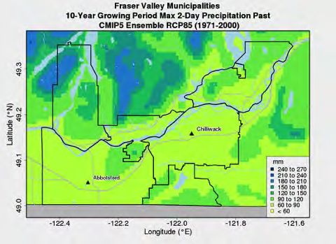
Fraser Valley Climate Adaptive Drainage Management Forum

TABLE OF CONTENTS
1     INTRODUCTION ............................................................................................................................... 1

    1.1     Project Motivation ................................................................................................................... 1

    1.2     Project Objectives .................................................................................................................... 1

    1.3     Project Methods ...................................................................................................................... 2

2     FRASER VALLEY RUNOFF AND DRAINAGE MANAGEMENT CHALLENGES ....................................... 4

    2.1     Existing Issues .......................................................................................................................... 4

    2.2     Current agricultural drainage criteria ...................................................................................... 4

    2.3     Projected climate changes in the Fraser Valley ....................................................................... 5

    2.4     Implications of climate change for drainage management ................................................... 12

3     CLIMATE ADAPTIVE DRAINAGE MANAGEMENT – POTENTIAL COLLABORATIVE STRATEGIES...... 12

    3.1     Whatcom County – An Illustrative Example .......................................................................... 12

    3.2     Potential Strategies for the Fraser Valley .............................................................................. 15

4     ADVANCING FRASER VALLEY CLIMATE ADAPTIVE DRAINAGE MANAGEMENT ............................ 22

    4.1     Potential Action Projects ....................................................................................................... 22

    4.2     Early Opportunities ................................................................................................................ 23

APPENDIX 1            FORUM PARTICIPANTS ................................................................................................ 24

APPENDIX 2            CLIMATE CHANGE PROJECTION FIGURES ................................................................... 26

APPENDIX 3            ADDITIONAL CLIMATE ADAPTIVE DRAINAGE MANAGEMENT CASE STUDIES............. 29

APPENDIX 4            POTENTIAL FUNDING MECHANISMS .......................................................................... 33

APPENDIX 5            RESEARCH CONTACTS ................................................................................................. 35

APPENDIX 6            WEB RESOURCES ......................................................................................................... 36

APPENDIX 7            REFERENCES ................................................................................................................ 38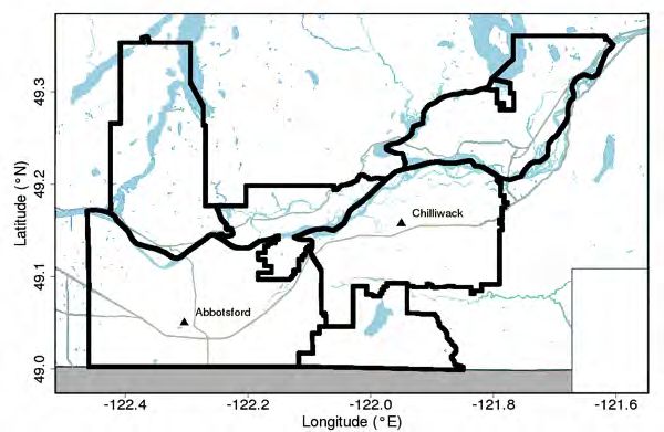
Fraser Valley Climate Adaptive Drainage Management Forum

1 INTRODUCTION

1.1      Project Motivation

In the Fraser Valley, climate change is projected to result in a significant increase in annual precipitation
with much of this falling as rain (and less as snow) during the winter, spring and autumn. Rain will also
be concentrated in more frequent and intense precipitation events, resulting in greater challenges with
managing runoff (both onto and off) the predominantly low-lying agricultural land base.

Beginning in 2014, the Fraser Valley Adaptation Strategies planning process brought together
agricultural producers and local and provincial government partners to evaluate climate change impacts
on local agricultural production, and to develop strategies and actions to address the associated
challenges. With respect to agricultural drainage, actions to “develop a coordinated cross-agency
approach to agricultural ditch and drainage management” and “identify, pilot & evaluate mechanisms to
reduce runoff onto and off agricultural lands” were prioritized. (CAI, 2015)

As a first collaborative step to implement these actions, the Enhanced Collaboration for Drainage &
Ditch Management project, completed in Spring 2017, identified a number of areas for further
consideration and action. One of the most significant gaps identified was around planning for drainage
systems that are adapted for a changing climate. The study noted that: “In many areas, the drainage
system capacity has not been assessed for future climate scenarios. Therefore, regulatory and funding
requirements to address climate change impacts are not well understood.” (KWL, 2017)

Building forward from the previous work, this new project was initiated in the autumn of 2017 with the
intention of generating and sharing the best available precipitation projections for the Fraser Valley.
The project also includes a multi-jurisdictional scan because planning and managing for the potential
changes in frequency and intensity of extreme precipitation is a challenge facing many jurisdictions.
While the Fraser Valley will require its own locally suitable approaches, examples of innovative upland
runoff and lowland drainage can help to inform “climate adaptive drainage.”

The final element of the new project was a Forum – hosted in January of 2018 – to support a dialogue
between producers, local government and key agency staff and other specialists about how the
projected precipitation changes impact planning, decision-making, research and farm level
management. The Forum was also intended to generate a sub-set of favoured potential projects or
solutions to support improved drainage and runoff management.

1.2      Project Objectives
The Fraser Valley Climate Adaptive Drainage Management Forum (“Forum”) project was initiated to:

1 Develop more specific and detailed indicators for projected precipitation changes;
2 Research collaborative climate adaptive drainage management strategies adopted in comparable
  settings; and,

                                                                                                       Page 1
Fraser Valley Climate Adaptive Drainage Management Forum

3 Host a Forum between producers, local government and agency staff, researchers and agricultural
  association representatives to discuss the implications of increased precipitation for agricultural
  drainage in the Fraser Valley, and to deliberate preferred feasible and effective strategies to advance
  in the region.

1.3       Project Methods

1 .3 .1       P re c ip ita tio n P ro je c tio n s

The Pacific Climate Impacts Consortium (PCIC) developed updated climate/precipitation projections for
the Fraser Valley using standard, well-established analytical methods and models that have been used
for other BC jurisdictions such as Metro Vancouver. The study area (Figure 1), established by the Project
Management Committee (PMC), includes the municipalities of Abbotsford and Chilliwack, the Districts
of Mission and Kent, and Electoral Areas G (Nicomen Island/Deroche/Dewdney/Hatzic Island) and H
(Cultus Lake/Columbia Valley/Lindell Beach) of the Fraser Valley Regional District (FVRD).

Figure 1 | Study Area (combined municipal areas outlined in black, thickened for emphasis)

1 .3 .2       Research Scan

The previously completed project – Enhanced Collaboration for Drainage & Ditch Management –
engaged representatives of local governments, regulatory agencies, producers, and specialists to assess
and summarize key issues facing runoff and drainage management in the Fraser Valley, as well as
several management strategies for further consideration and action.

                                                                                                    Page 2
Fraser Valley Climate Adaptive Drainage Management Forum
Using this earlier work as the basis for researching collaborative climate adaptive drainage management
strategies for consideration at the Forum, interviews were conducted with knowledge experts identified
by the PMC plus those discovered through the research itself. For some options, case studies were
developed to highlight their benefits and outline implementation considerations learned from other
jurisdictions. The results of Research Scan, including lists of interviewees, references and website
resources, are provided as appendices to this report.
1 .3 .3 F o ru m W o rk s h o p
The Forum objectives and workshop design were developed in conjunction with the PMC. The objectives
included:
• Establish a shared understanding of new precipitation projections to 2050 and their implications
for drainage requirements in the Fraser Valley;
• Discuss and evaluate collaborative approaches for climate adaptive runoff and drainage
management;
• Discuss early opportunities to advance preferred Climate Adaptive Drainage Management
initiatives.
Thirty-one participants attended the event, including 10 producers (Dairy, Berry, Poultry, Vegetable and
Nursery sectors); 6 Agency staff (BC Ministry of Agriculture and Ministry of Forests, Lands, Natural
Resource Operations & Rural Development); 8 Local Government staff (Fraser Valley Regional District,
District of Kent, City of Chilliwack, District of Mission, and City of Abbotsford); 4 NGO representatives
(Stewardship Centre for BC, ARDCorp, Partnership for Water Sustainability in British Columbia, and
Climate Action Initiative); and 4 Researchers/Consultants (UBC, Environmental Dynamics Ltd). A list of
participants is provided in APPENDIX 1 Forum Participants.
The Forum included plenary presentations and discussion of the following topics:
• Agricultural drainage for multiple values – revisiting infrastructure requirements and funding -
Ted van der Gulik, Partnership for Water Sustainability in British Columbia (PWSBC).
• Future climate information for agricultural drainage - Trevor Murdock, Pacific Climate Impacts
Consortium (PCIC).
• Collaborative regional runoff and drainage management approaches in Whatcom County,
Washington - Chris Elder, Planner, Whatcom County Agriculture Program.
• Updates to the Environmental Farm Plan (EFP) Drainage Management Guide - Jennifer Prive,
Environmental Dynamics Inc.
Potential management strategies to address existing and future management challenges for the Fraser
Valley were presented for discussion within small groups, and to inform a priority ranking exercise for
individual participants. After identifying any important overlooked issues and strategies, participants
assessed each strategy according to (1) Effectiveness, (2) Commonality (applicability across the region
and to different sectors), and (3) Feasibility; and in terms of which strategies they would prefer to be
implemented in the near and long term.
Page 3Fraser Valley Climate Adaptive Drainage Management Forum
The Forum concluded with a brief discussion of the value of continued Forum-style workshops and
potential next steps.
2 FRASER VALLEY RUNOFF AND DRAINAGE MANAGEMENT
CHALLENGES
2.1 Existing Issues
The Fraser Valley is facing numerous management challenges (issues) with respect to maintaining and
adapting agricultural drainage. These issues pertain to increasing physical runoff volumes and duration
which will also exacerbate existing challenges with complex/lengthy regulatory processes and funding
and knowledge gaps.
For the most part, higher runoff volume and duration is due to climate change and increased upstream
development; lengthier and more complex regulatory processes are due to increasing habitat
requirements and reduced capacity of regulatory agencies; funding gaps are as a result of increased
infrastructure requirements coupled with declining government drainage financing programs; and
knowledge gaps are attributable to insufficient and/or disparate knowledge and training resources
available to producers and specialists supporting the sector.
2.2 Current agricultural drainage criteria
The agriculture drainage criteria established for BC is based on the Agricultural and Rural Development
Subsidiary Agreement (ARDSA) criteria originally developed in the 1960/70s. The ARDSA criteria describe
the level of drainage required to allow for good on-farm drainage while achieving a positive agronomic
return on drainage investment. The criteria accepted some risk, since more stringent criteria would be
too costly for projects to proceed. (van der Gulik, 2017a)
In terms of extreme precipitation events, the design storms were established as:
1. Remove the runoff from a 10-year, 5-day storm, within 5 days in the dormant period (November
1 to February 28);
2. Remove the runoff from a 10-year, 2-day storm, within 2 days in the growing period (March 1 to
October 31).
In between storm events and in periods when drainage is required, the base flow in channels is to be
maintained at 1.2 m below field elevation; and for both peak and base flows, the conveyance system
must be sized appropriately.
Drainage remains one of the primary limiting criteria for agricultural production in the Fraser Valley.
(van der Gulik 2017b) Effective drainage supports crop health and productivity as well as maintaining
field trafficability. Regional drainage requires both adequate regional conveyance and effective on-farm
drainage management.
Page 4Fraser Valley Climate Adaptive Drainage Management Forum
However, several changing conditions and pressures are impacting the effectiveness of existing drainage
infrastructure, including (van der Gulik, 2018):
• In some cases, farm level drainage systems may not be optimal for several reasons. In general,
there is a lack of qualified drainage contractors (anecdotally only one in B.C.); installation costs
of tile drainage are high; ongoing maintenance is required to maintain tile drainage function;
challenges exist with on-going maintenance of constructed surface ditches due to species
habitat requirements and delayed regulatory approvals; and cost-sharing/funding programs
available to producers are limited/minimal.
• Local governments are not achieving the current level of ARDSA agriculture drainage criteria for
several reasons including high capital costs; challenges with on-going maintenance due to
species habitat requirements and delayed regulatory approvals; upland runoff, which was not
originally considered within the ARDSA agricultural drainage criteria, is increasing lowland
drainage burdens; and storm event rainfall amounts are significantly increasing due to climate
change;
• Additional landscape and infrastructure values, which did not exist when the ARDSA agricultural
drainage criteria were established, are adding to drainage requirements. This includes fish and
other species habitat; housing developments; highways, roads and bridges; water and sewage
lines; power transmission lines; and railroads.
2.3 Projected climate changes in the Fraser Valley
Several standard climate change indicators were chosen to characterize climate change effects on
precipitation affecting Fraser Valley runoff and drainage management. Added to these were indicators
based on the ARDSA criteria design storm events to better support Forum deliberations. Except for the
devised ARDSA criteria, the definitions are largely based on those used in the Climate Projections for
Metro Vancouver study. (Metro Vancouver, 2015)
Each of these indicators are computed using a set of 12 Global Climate Models (GCMs), based on the
internationally recognized “business as usual” greenhouse gas emissions scenario (Representative
Concentration Pathway 8.5, or RCP8.5), and statistically downscaled to the ~10 km grid of the ANUSPLIN
historical dataset (see https://pacificclimate.org/data/statistically-downscaled-climate-scenarios for
more information on the GCMs, ANUSPLIN, and the BCCAQ statistical downscaling method). Further bias
correction using the high-resolution (~800 m) climatology was performed to produce the maps of each
indicator (see https://pacificclimate.org/data/high-resolution-prism-climatology for more information
on PRISM). For a more in-depth description of climate modelling, see the Methodology section of the
Climate Projections for Metro Vancouver study. (Metro Vancouver, 2015)
The resulting precipitation indicators and their baseline/predicted values are shown in Table 1 on page
7. Baseline (1971-2000) values correspond to the historical gridded (~10 km) values inside the Study
Area outlined in Figure 1 on page 2. The 2050s change for the same area is based on the difference
between the 2041-2070 average and the 1971-2000 baseline for each downscaled projection (following
Page 5Fraser Valley Climate Adaptive Drainage Management Forum
RCP8.5 emissions). They are generally represented as % change from the baseline value, except for time
values where units are expressed in absolute terms. Negative values mean that the change is downward,
i.e. reduced in the future compared to the present.
The values are presented using the following convention:
22% (5 to 37%)
where the first value (in this example, 22%) is the average of all 12 runs over the 2041-2070 period. The
values in brackets represent the 10th percentile (in this example, 5%) to 90th percentile (in this example,
37%) of results from the 12 runs over the 2041-2070 period. This range reflects both climate model
uncertainty as well as natural variability. It is prudent to plan for the full range of change in the 10th to
90th percentile, not just the mean change.
The inclusion of the District of Mission was tested to see whether its greater proportion of high-
elevation areas skewed the regional averages shown in in Table 1. This effect was not observed
(Murdock, 2018).
The results for several indicators are also shown spatially across the Study Area. For example, Figure 2
shows the change in 1-in-20 wettest day storm events by the 2050s for the average of 12 GCMs
(following RCP8.5 emissions). Per the indicator projections in Table 1, it represents a 22% increase in the
intensity of the event over the entire Study Area outlined in black on the map. Additional spatial
representations for select indicators are available in APPENDIX 2.
Figure 2 | Projected Change in 1-in-20 Wettest Day Precipitation by 2050s
Page 6Fraser Valley Climate Adaptive Drainage Management Forum
1
Table 1 | Climate change projections
Baseline Projected
value change from
Indicator Definition Interpretation
(1971- baseline by
2000) 2050s
1-in-20 A day so wet that it has only a one-in- 114 mm 22% (5 to 37%) Considerably more precipitation (about 20%
wettest day twenty chance of occurring in a given year. on average) is expected to fall during the 1-in-
precipitation That is, there is a 5% chance in any year that 20 extreme one-day precipitation events in
a one-day rainfall event of this magnitude the future.
will occur. This indicator points to what we
can expect in terms of extreme one-day
precipitation events in the region.
The 1-in-20 wettest day can be expressed as 20 years 10 years Extremely wet days (1-in-20 wettest day) that
a Return Interval, which indicates how (4 to 19 years) used to occur once every 20 years are
frequently the Baseline 1-in-20 wettest day projected to occur about twice as often by the
precipitation amount (114 mm) is projected 2050s.
to occur.
Growing Corresponds to the ARDSA growing season 91 mm 18% (-1 to 44%) The precipitation amount for the ARDSA
season extreme design storm. This describes the growing season extreme design storm is
storm amount of precipitation that falls within a 2- projected to increase by about 20% on
day storm event, during the period Mar 1 to average, although in any given year it could
Oct 31, that has a 1-in-10 chance per year of increase by 40% or more.
occurring.
1
All values averaged over the 12 climate model runs for the RCP 8.5 emission scenario.Fraser Valley Climate Adaptive Drainage Management Forum
Baseline Projected
value change from
Indicator Definition Interpretation
(1971- baseline by
2000) 2050s
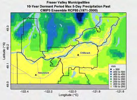
Dormant Corresponds to the ARDSA dormant season 216 mm 10 (-2 to 23) % The precipitation amount for the ARDSA
season extreme precipitation design storm. This dormant season extreme design storm is
storm describes the amount of precipitation that projected to increase by about 10% on
falls within a 5-day storm event, during the average, although in any given year it could
period Nov 1 to Feb 28, that has a 1-in-10 increase by 20% or more.
chance per year of occurring.
Total All precipitation summed over a season or Projections indicate that the Fraser Valley will
precipitation year, including rain and snow water experience an increase in total annual
equivalent. This is a high-level indicator of precipitation of a modest 5% by the 2050s.
how precipitation patterns are projected to While this is a relatively small difference from
change. Seasons are defined as Winter the past, the increase will be distributed
(December-February), Spring (March-May), unevenly over the seasons. While most rain
Summer (June-August) and Fall (September- will continue to fall over the winter months,
November). the largest percentage increase in rainfall will
occur in the Spring and Fall (about 10% more
Winter(DJF) 663 mm 5% (-3 to 12%)
by the 2050s). Summer, already the region’s
Spring(MAM) 423 mm 9% (-4 to 19%) driest season, will experience a decline of
about 20% by the 2050s. While the models
Summer(JJA) 223 mm -19% (-40 to 1%) indicate a range of possible change, they
Fall(SON) 556 mm 11% (-2 to 26%) mostly agree about the direction of change for
each season.
Annual 1888 mm 5% (-1 to 10%)
Page 8Fraser Valley Climate Adaptive Drainage Management Forum
Baseline Projected
value change from
Indicator Definition Interpretation
(1971- baseline by
2000) 2050s
Single-day Describes the largest amount of rain that Despite the slight increase noted above in
maximum falls on any single day in the year. This value total annual precipitation by the 2050s, the
precipitation is used to understand how extreme increases are projected to be more
precipitation will change over time. Results concentrated within the wettest days in the
are summed for each season and year. Fall, Spring and Winter seasons.
Winter(DJF) 58 mm 15% (2 to 31%)
Spring(MAM) 38 mm 16% (-1 to 33%)
Summer(JJA) 32 mm -1% (-24 to 24%)
Fall(SON) 59 mm 19% (-3 to 52%)
Annual 72 mm 18% (6 to 34%)
Five-day Describes the largest amount of rain that Like the single-day maximum precipitation,
maximum falls over a period of 5 consecutive days in increases are projected to be more
precipitation the year. Results are summed for each concentrated within the wettest days in the
season and year. Fall, Spring and Winter.
Winter(DJF) 136 mm 9% (3 to 24%)
Spring(MAM) 87 mm 12% (-3 to 23%)
Summer(JJA) 63 mm -3% (-25 to 21%)
Fall(SON) 135 mm 15% (-3 to 40%)
Annual 161 mm 14% (6 to 27%)
Page 9Fraser Valley Climate Adaptive Drainage Management Forum
Baseline Projected
value change from
Indicator Definition Interpretation
(1971- baseline by
2000) 2050s
Precipitation Total annual precipitation that occurs on 406 mm 34% (3 to 64%) The wettest periods in the region are
during wet days that are wetter than 95% of days on projected to become even wetter. The wettest
days which precipitation occurs (“R95p wet days that exceed the baseline 95th percentile
days”). threshold will produce about a third more rain
by the 2050s.
Annual wet The number of times per given year that 4 times 6 times The wettest days of the year are projected to
days within R95p wet days occur within 5 days of each (4 to 7 times) occur close together more frequently
5 days other.
Dormant The average duration between R95p wet 25 days 20 days The wettest days of the ARDSA dormant
season - days within the ARDSA dormant season (17 to 23 days) season are projected to occur more closely
duration (Nov 1 to Feb 28). together.
between
wet days
Dry spell Number of consecutive days with daily 20 days 25 days Dry spells are expected to increase in length
duration precipitation is less than 1 mm. The value (22 to 29 days) by about 25% by the 2050s.
denotes the longest stretch of dry days in a
year, typically in summer. This number does
not indicate extreme droughts, as it is
averaged over the 30-year period
Growing An annual measure that counts the number 272 days 324 days In the past, the Fraser Valley had an average of
season of days between the first span of at least 6 (310 to 329 days) 272 days in the growing season. By the 2050s,
length days with a daily average temperature about 50 days will be added, resulting in an
greater than 5°C, and first span after July 1 almost year-round growing season (roughly
of 6 days with a temperature less than 5°C. 90% of the year on average).
It indicates the length of the growing season
for typical plants or crops in our region.
Page 10Fraser Valley Climate Adaptive Drainage Management Forum
Baseline Projected
value change from
Indicator Definition Interpretation
(1971- baseline by
2000) 2050s
Growing A measure of heat accumulation that is 1957 2857 degree- Growing degree days are projected to
degree days useful for agriculture and horticulture. degree- days significantly increase by the 2050s, rising by
Growing degree days are calculated in this days (2446 to 3229 about 50% on average.
region by how much warmer daily degree-days)
temperatures are compared to a base
temperature of 5°C (although different base
temperatures may be useful for different
crops). For example, if a day had an average
temperature of 11°C, that day would have a
value of 6 growing degree days. Annual
growing degree days are accumulated this
way for each day of the year and then
summed. This measure is a useful indicator
of opportunities for agriculture, as well as
the potential for invasive species to thrive.
Frost days Represents the annual count of days with a 60 days 24 days Future projections indicate conditions where
night-time low temperature below 0°C. (14 to 39 days) the “new normal” would be a regional climate
that is almost entirely frost-free. The number
of frost fee days in the region is projected to
decline from 60 days on average to about 25
days by the 2050s.
Page 11Fraser Valley Climate Adaptive Drainage Management Forum
2.4 Implications of climate change for drainage management
The climate projections indicate that changes in Fraser Valley precipitation patterns will considerably
increase the agricultural drainage burden. Compared to past climate (1971 – 2000) in the region,
average values for the following precipitation indicators are projected to increase by ~2050 as follows:
• Compared to the rest of the year, increases in total precipitation and maximum storm
precipitation amounts will be largest during Spring (March, April, May) and Fall (September,
October, December) when field trafficability is particularly important.
• The precipitation amount for the ARDSA growing season extreme design storm is projected to
increase by about 20%, although in any given year it could increase by 40% or more.
• The precipitation amount for the ARDSA dormant season extreme design storm is projected to
increase by about 10%, although in any given year it could increase by 20% or more.
• Considerably more precipitation (about 20%) is expected to fall during extremely wet days (1-in-
20 wettest day) in the future. Extremely wet days that used to occur once every 20 years are
projected to occur once every 10 years.
• The wettest periods in the region are projected to become even wetter (by about 35%), and the
wettest days of the year are projected to occur more closely together.
Given these projections, and with parts of the region already not meeting the ARDSA criteria (KWL,
2017), the probability of increased crop losses and localized flooding is likely to rise without
incremental intervention and investment in improved drainage management and infrastructure.
3 CLIMATE ADAPTIVE DRAINAGE MANAGEMENT – POTENTIAL
COLLABORATIVE STRATEGIES
3.1 Whatcom County – An Illustrative Example
The Research Scan highlights several case studies of jurisdictions outside of the Fraser Valley that have
pursued various planning approaches, practices and technologies to address runoff and drainage
management challenges in the face of climate change. Of these, Whatcom County, located just south of
the Fraser Valley in the State of Washington, offers the most illustrative example of how collaborative
strategies can help to address drainage management challenges associated with climate change,
endangered species, and upland development. See APPENDIX 2 for the remaining case studies.
To meet such challenges Whatcom farmers and government agencies established several collaborative
entities and initiatives to proactively assess, plan, and implement Drainage Management Plans (DMPs).
Stakeholders participate through several coordinating bodies, including the Whatcom Conservation
District and Watershed Improvement Districts.
Established in 1948, the Whatcom Conservation District is a non-regulatory agency that offers free farm
planning services to providers and acts as a liaison between producers, improvement districts, and
Page 12Fraser Valley Climate Adaptive Drainage Management Forum
various levels of governments and agencies. It has several valuable resources that producers and
drainage contractors can access.
Watershed Improvement Districts, founded under Washington State law, are “farmer-led” district
bodies that represent the needs of the agriculture community. A WID is a type of special purpose
district, governed by landowners, that is apart from any city or county, with its own governance
(producer Boards), staff and assessment authority. While WIDs are legally organized as an “irrigation”
district under Washington state law, they have statutory authority to work on a variety of issues –
including water supply, water quality, drainage, and habitat restoration. (SVPA, 2015)
Addressing drainage on a systematic basis, rather than parcel by parcel, was one of the key reasons
WIDs were formed. A WID addresses drainage by working with agency partners to evaluate drainage
problems, design solutions, and identify funding sources as part of developing and implementing DMPs
(see below). In addition, the WID approach allows for the management of species habitat in ways that
can fit with agricultural drainage needs and permits solutions in response to distinct farming types in
different areas. (Elder, 2018)
The WIDs are additionally organized together into the Ag Water Board [sic] with the goals of:
• jointly cooperating on organizational, administrative, legal, engineering, and other services for
all WIDs in a manner that provides cost savings and efficiencies;
• representing the collective interests of the WIDs in project and policy efforts with other
interests and agencies;
• ensuring transparency and accountability in the operation of WIDs by establishing uniform
procedures, education, and training opportunities for WIDs.
Each of the six Whatcom County WIDs has developed a Drainage Management Plan (DMP) to achieve
(Boggs, 2009):
• Better knowledge of drainage system infrastructure based on reach by reach assessments.
• Easier permitting using agreed upon Best Management Practices (BMPs).
• Certainty of permit requirements based upon watercourse classification.
• Cost savings from using new or different drainage management techniques.
• Easier budgeting once maintenance needs are assessed.
• Potential for funding once enhanced drainage opportunities are identified and prioritized.
• Directing five-year workplans.
The DMPs were developed collaboratively between local WIDs/landowners, conservation districts, local
government and state agencies and regulators. Included in the DMP planning process are the following
steps (Boggs, 2009):
Step 1 - Prepare a general overview of the drainage basin
Step 2 - Map and classify watercourses
Step 3 - Inventory and map other infrastructure
Page 13Fraser Valley Climate Adaptive Drainage Management Forum
Step 4 - Map significant natural resources
Step 5 - Identify maintained watercourses and divide into reaches
Step 6 - Schedule drainage maintenance work by reach
Step 7 - Adopt Best Management Practices
Step 8 - Identify habitat improvement projects and set goals
Step 9 - Adopt monitoring, reporting and Adaptive Management Plans
An approved DMP, when combined with appropriate permit applications, results in a “shovel ready”
five-year work plan. A guide for developing DMPs and a list of completed plans is available online at:
http://www.whatcomcd.org/sites/default/files/publications/dmg/DMG_Final.pdf
Several management strategies employed in developing and implementing the Whatcom DMPs are
readily transferrable to the Fraser Valley. They include:
Long-term / area-wide permitting. As within the Fraser Valley, the regulatory process to apply and
receive ditch maintenance approvals is considerably complex due to the existence of multiple
management objectives amongst different regulatory agencies. To increase the efficiency and timeliness
of ditch maintenance permitting, the DMPs implement longer term (5-year) and/or area-wide
permitting plans in collaboration with regulatory agencies (Elder, 2017). This reduces individual
permitting efforts for producers, local governments and regulators alike.
Regional opportunity assessments. One of the first steps in developing a DMP is to conduct a region
wide assessment of drainage enhancement opportunities in a systematic way. Local and on-farm level
action can then be focused within the context of a larger scale plan; and the larger scale plan can help to
identify priorities and potential funding for rewarding local and on-farm projects. While the process has
shown exciting potential to assist in management of runoff and drainage, it requires increased outreach
and communication with the producers to achieve full benefits. (Elder, 2017)
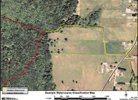
Standardized management prescriptions by watercourse. Like watercourse classifications in BC,
watercourses have been identified and classified under a regional scheme. The classifications include
constructed, modified and natural watercourse. Each classification has predetermined activities and
BMPs prescribed to them (Figure 3). To ensure that the benefits of the classification system are realised
extensive outreach is needed with producers so that they understand activities associated with the
classification system. (Elder, 2017)
Page 14Fraser Valley Climate Adaptive Drainage Management Forum
Figure 3: Example Water Course Classification Mapping
Cost-sharing arrangements. Several financing strategies have been adopted to encourage habitat
protection and BMPs by landowners. Strategies include sharing costs between neighbouring landowners
that are managing/protecting the same waterway and a leasing model whereby producers who convert
farmland to riparian buffers receive long-term (15-year term, renewable to 30-years) government lease
payments to offset capital and maintenance costs and any associated loss of farm revenues.
Extension initiatives to improve BMPs. Whatcom County has undertaken several studies in conjunction
with universities to examine BMPs for enhancing watershed function at the agricultural level. In one
study, they found that narrow (5’to 15’ wide) densely planted riparian buffers are as effective as wider
(35’-180’ wide) buffers with respect to reducing air temperature and creating shade. Experiments were
conducted to identify which riparian plant types were most appropriate for different conditions and help
to reduce weeds and pests (Benedict et al., 2012).
Knowledge Transfer – Online Tools. The Ag Water Board has implemented an online “story map” that
serves as an effective tool for “giving farmers a voice” and sharing agriculture and watershed knowledge
and project activities with farmers, regulators and the public. It is available online at:
http://www.agwaterboard.com/storymap
3.2 Potential Strategies for the Fraser Valley
Table 2 provides a succinct list of collaborative management strategies (options) that were identified
through research and Forum deliberation as potentially useful to address the Fraser Valley drainage
Page 15Fraser Valley Climate Adaptive Drainage Management Forum
management challenges. Note that the list is not considered exhaustive; its purpose was to distill the
most relevant approaches into a list suitable for discussion at the Forum.
Forum participants evaluated these strategies as part of group discussion and individual ranking. Those
strategies that generally ranked higher in terms of effectiveness, feasibility, and commonality; and were
favoured to begin in the near term (in several cases, likely due to being easier and faster to achieve)
and/or to be pursued over the long term (in several cases, likely due being more complex/harder to
achieve yet still beneficial enough to be worth the additional effort) are highlighted in green in Table 2.
In addition, a few strategies generally ranked near the bottom because of perceived limited
application/benefit across the region – these are highlighted in red.
Group discussion identified some additional concerns and/or potential strategies that are not shown in
this list. These include:
• Collaborating with local First Nations;
• Irrigation and water quality requirements are also important considerations for coordinated
water basin management and planning; and
• Investigating potential solutions for farms on leased land where investment in subsurface tile
drainage is complicated by the ownership/leasing structure.
Page 16Fraser Valley Climate Adaptive Drainage Management Forum
2
Table 2 | Potential Collaborative Runoff and Drainage Management Strategies
Category Issue Potential Collaborative Strategy
Coordinated Lack of communication and coordination Implement / rejuvenate producer-led agricultural water management councils
Management between government agencies, First to give producers a voice, offer training and cost-sharing services, and find
and Planning Nations, and agricultural stakeholders. collaborative solutions.
Conduct a region-wide assessment of collaboration opportunities to identify
primary management options at a landscape level. The assessment could include
advising on the suitability of different soil and hydrological profiles to support
certain crop types versus others, as well as identify projects that could serve
overall drainage basin objectives with corresponding funding opportunities.
Expanding objectives, requirements and Pilot a multi-stakeholder, multi-objective drainage basin planning process with
uses/beneficiaries of drainage networks. representation from producer associations, relevant agencies, First Nations,
regional and local governments, and related interests. Planning would need to
consider both urban and rural activities on water management schemes.
Permitting and maintenance is delayed Classify watercourses by habitat requirements and prescribed management
and/or difficult to conduct when critical activities. Update landscape level surveys to determine the most suitable and
habitat associated with species at risk effective activities that can be applied at the farm level to help with runoff and
and biodiversity are associated with a drainage. In Whatcom County, agreements on maps have helped to increase the
watercourse. In some cases, the species level of management certainty for all parties. (Elder 2017)
requirements are not well understood or
defined.
2
Strategies highlighted in green were generally ranked higher by Forum participants in terms of effectiveness, feasibility, and commonality, and were favoured
to begin in the near term and/or to be pursued over the long term. Strategies highlighted in red were generally ranked near the bottom.Fraser Valley Climate Adaptive Drainage Management Forum
Category Issue Potential Collaborative Strategy
Lack of clarity and agreement regarding Revisit and update agricultural drainage criteria considering the full suite of
suitability of existing ARDSA criteria in a uses and values at risk, risk tolerance and funding availability, and evolving crop
changing climate and for different crop types. Given the greater volumes of upland and on-farm runoff anticipated with
types over time. climate change, the increased costs of drainage infrastructure and changing
agronomics and economics for agriculture, and evolving and widening risk
tolerance across the region, a review of criteria with updated risk assessment
and cost-benefit analysis is likely warranted.
Differing and/or uncertain application Conduct a region-wide assessment of drainage/water management
level of design criteria across the region; requirements and gaps.
increasing need for summer irrigation
due to climate change; increasing water
quality objectives.
Infrastructure Undersized agriculture drainage capacity Increase watercourse, culvert, pump and/or flood box capacities.
Requirements to meet increased volume and duration
of water flows arising from increasing
extreme rainfall events and additional
upland stormwater contributions.
Reduce duration and peak volume of urban stormwater inflows by minimizing
impervious areas in the watershed and improving watershed hydrologic function
through retention and infiltration of rainwater.
Investigate the return on investment (ROI) of controlled tile drainage to reduce
peak runoff into conveyance systems; reduce drainage conveyance
maintenance, improve groundwater levels in droughts and improve nutrient
retention.
Page 18Fraser Valley Climate Adaptive Drainage Management Forum
Category Issue Potential Collaborative Strategy
Investigate the ROI and funding opportunities of retention ponds in low lying
areas where excess water can infiltrate groundwater or otherwise delay release
into the conveyance network. Retention ponds additionally reduce sediment
runoff which when captured can be periodically harvested. A major
consideration is the opportunity cost associated with alienating productive crop
land. High land values in the Fraser Valley may reduce the economic return of
this strategy to unacceptable values (Lapen, 2017). They are currently being
piloted in agricultural areas within Whatcom County.
Operation & Complex regulatory processes preventing Increase the adoption of multi-year, area-wide permitting to improve
Maintenance or delaying drainage maintenance. timeliness and efficiency of permit applications and approvals. Efficiencies
benefit all parties involved, including producers, local governments, and
regulators. Examples exist in Abbotsford, Chilliwack, and the District of Kent
(Barrett, 2017).
Lack of local and experienced Qualified Investigate incentives to increase the number of locally knowledgeable QEPs
Environmental Professionals (QEP) and (Qualified Environmental Professionals)
drainage contractors.
Page 19Fraser Valley Climate Adaptive Drainage Management Forum
Category Issue Potential Collaborative Strategy
Unrealized use of on-farm drainage best Investigate the synergistic effects and ROI of on-farm BMPs, including:
management practices (BMPs) to • Enhancing soil organic matter to improve water holding capacity and improve
minimize watercourse capacity and winter water dynamics for infiltration and retention. Soil which has more organic
maintenance requirements content to retain water longer, as well as provide associated benefits including
nutrient cycling and carbon storage (Smukler, 2017).
• Maintaining bank and forest vegetation to slow or reduce runoff and reduce
ditch maintenance. Additional potential agronomic and ecological benefits can
include maintaining bank stability and water quality, shading water and
providing habitat for fish and aquatic species, controlling sediment, nutrient, and
bank erosion, and shading out Reed canary grass. Potential disadvantages
include attract or encouraging noxious weeds and pests such as insects, birds,
rodents, ungulates and predators such as coyotes.
• Use of buffers and berms or raised ground between watercourse banks and
crop lands. This helps to reduce sediment losses and decrease the amount of
ditch maintenance needed. It also improves infiltration and has added benefits
to the environment.
• Seasonal crop cover, including grasses, clover and herbaceous plants, in rainy
and windy seasons to reduce unprotected soils and enhance soil organic matter.
It reduces the need for ditch maintenance as well as improves infiltration and
holding capacity of water in soils (Bradbeer, 2012).
Financing and Financing of infrastructure upgrades. Investigate new or expanded local government drainage financing, including
Affordability utility models, local area service taxes, user fees, development cost charges
(DCC), habitat leases and insurance sector investment.
Investigate potential infrastructure improvement grants from federal and
provincial governments and municipal associations.
Educate local councillors, MLAs and MPs and public about the importance of
adequate and effective Agricultural drainage;
Page 20Fraser Valley Climate Adaptive Drainage Management Forum
Category Issue Potential Collaborative Strategy
Feasibility and affordability of on-farm Investigate the addition or expansion of drainage management cost sharing
investments. services for on-farm runoff and drainage design, installation, and maintenance.
This could be associated with producer-led agricultural water management
councils.
Investigate potential grants for regional and on-farm improvements and
adaptations to climate change, e.g. Farmland Advantage, FRISP, and IAFBC.
Knowledge Ineffective or hard to access education Compile relevant research and information resources, including knowledge held
Transfer materials regarding drainage by retiring/retired agency staff.
requirements, regulations, and best
management practices.
Develop an on-line drainage management decision support tool to help inform
and determine required and/or cost-effective BMPs at the farm level. This could
include map-based inventories and communication.
Modernize web and print materials, including delivery in multiple languages.
Inefficient or insufficient working Investigate the creation of a drainage management liaison role to assist
relationships between regulators and producers with design and maintenance of surface and subsurface drainage. The
ditch maintenance authorities, position could be associated with existing producer associations with financial
contractors and/or producers. assistance from government.
Increase the availability and knowledge of drainage contractors, especially
given their intermediary role between authorities and clients. As a key
knowledge group dealing with ditch and drainage maintenance, drainage
contractors could be targeted for additional training on issues such as species at
risk and tile maintenance.
Increase stakeholder collaboration through regular workshops.
Page 21You can also read