Manchester City, Salford City and Trafford Councils Level 2 Hybrid SFRA - USER GUIDE
←
→
Page content transcription
If your browser does not render page correctly, please read the page content below

Manchester City, Salford City
and Trafford Councils
Level 2 Hybrid SFRA

USER GUIDE
Final
May 2010

Trafford Council
Sale Waterside
Sale
M33 7ZF
Structure of the Manchester, Salford and Trafford SFRA
The Manchester City, Salford City and Trafford Councils Level 2 Hybrid SFRA is supplied
as four Volumes, described in the table below. Readers should refer to SFRA User Guide
for guidance on how to use the information provided in the SFRA.

 SFRA Volume        Contents

 User Guide         This provides detailed guidance for Policy
                    Planners, Development Control Officers and
                    Emergency Planners on their responsibilities
                    within regional and local flood risk management
                    as defined within PPS25 and the use of the SFRA
                    as a supporting tool.
 Level 1 SFRA       The Level 1 SFRA has used mostly existing data to make
                    an assessment of flood risk from all sources now and in
                    the future and builds on the Association of Greater
                    Manchester Authorities (AGMA) Sub-Regional SFRA. It
                    looks at the risk of flooding from rivers, canals, reservoirs,
                    groundwater and surface water / sewers. It provides
                    evidence for LPA officers to apply the Sequential Test and
                    identify the need to pass the Exception Test where
                    required.

 Level 2 SFRA       The Level 2 SFRA provides more detailed information on
                    flood risk from rivers (The Lower Irwell, Grey Irwell, Rivers
                    Irk, Medlock and Mersey and the Corn Brook), canals
                    (Manchester Ship Canal and the Bridgewater, Rochdale
                    and Ashton Canals) and surface water / sewers.
                    It also looks at the impacts of development on flood risk
                    and the interactions between different sources of flooding.
                    The additional detail can also inform a sequential
                    approach to development allocation within flood risk areas,
                    the likelihood of sites passing the Exception Test and
                    mitigation options where appropriate.

 Maps               This volume collates the map outputs for the SFRA and
                    provides a Maps Index.

2009s0290 Final MST SFRA User Guide May 2010.docx                                     i
JBA Consulting
The Brew House
Wilderspool Park
Greenall's Avenue
Warrington
WA4 6HL

JBA Project Manager
Hannah O'Callaghan

Revision History
 Revision Ref / Date Issued             Amendments                             Issued to
 Draft v1.0 (October 2009)                                                     Colin Moss (TC), Fiona Moss
                                                                               (SCC), Helen Best (MCC) and
                                                                               Helen Telfer (EA)
                                                                               Colin Moss (TC), Fiona Moss
 Working Draft v2.0 (February
                                        EA and LPA comments                    (SCC), Helen Best (MCC) and
 2010)
                                                                               Helen Telfer (EA)
                                                                               Colin Moss (TC), Fiona Moss
 Final draft (May 2010)                 LPA comments                           (SCC), Helen Best (MCC) and
                                                                               Helen Telfer (EA)
                                                                               Colin Moss (TC), Fiona Moss
 Final (May 2010)                       EA comments                            (SCC), Helen Best (MCC) and
                                                                               Helen Telfer (EA)

Contract
This report describes work commissioned by Trafford Council, on behalf of Manchester
City, Salford City and Trafford Councils, by a letter dated 26 May 2009. Trafford‟s
representative for the contract was Colin Moss. Hannah O'Callaghan and Christoff Power
of JBA Consulting carried out this work.
Prepared by ....................................................................... Hannah O'Callaghan BSc
                                                                                    MCIWEM C. WEM
                                                                                    Senior Flood Risk Policy Analyst

Reviewed and approved by ............................................... Jonathan Cooper BEng MSc
                                                                         CEng MICE MCIWEM MloD
                                                                         DipCD

Purpose
This document has been prepared as a Final SFRA User Guide for Manchester City,
Salford City and Trafford Councils. JBA Consulting accepts no responsibility or liability for
any use that is made of this document other than by the Client for the purposes for which it
was originally commissioned and prepared.
JBA Consulting has no liability regarding the use of this report except to Manchester City,
Salford City and Trafford Councils.

2009s0290 Final MST SFRA User Guide May 2010.docx                                                                  ii
Acknowledgments
JBA Consulting would like to acknowledge the support of the SFRA steering group: Colin
Moss, Steve Hark (Trafford BC), Fiona Moss, Nigel Openshaw, Will Horsfall (Salford CC),
Helen Best, Andrew Parkin (Manchester CC), Helen Telfer and Chris Waring
(Environment Agency).
We would also like to thank Neil D‟Arcy at British Waterways for his contribution in
understanding the risk of flooding from canals and the Manchester Ship Canal Company.

Copyright
© Jeremy Benn Associates Limited 2010

Carbon Footprint

            304g

A printed copy of this document will result in a carbon footprint of 239g if 100% post-
consumer recycled paper is used and 304g if primary-source paper is used. These figures
assume the report is printed in black and white on A4 paper and in duplex.
JBA is a carbon neutral company and the carbon emissions from our activities are offset.

2009s0290 Final MST SFRA User Guide May 2010.docx                                          iii
Executive Summary
Introduction
Manchester City, Salford City and Trafford Councils are required to undertake a Strategic
Flood Risk Assessment (SFRA) as an essential part of the pre-production/evidence
gathering stage of the Local Development Framework (LDF) and in preparing their Local
Development Documents (LDDs). The SFRA provides baseline information for use in the
preparation of the Sustainability Appraisal (SA) of LDDs for the scoping and evaluation
stages.
The requirement for and guidance on the preparation of SFRAs is outlined in Planning
Policy Statement 25 Development and Flood Risk (PPS25) and its Practice Guide. This
requires Local Planning Authorities (LPAs) to take a more dominant role in local flood risk
management and to demonstrate that due regard has been given to the issue of flood risk
at all levels of the planning process to avoid inappropriate development. The minor
revisions to PPS25 in March 2010 are of no significance to the content of the SFRA. Any
future changes to national guidance will of course be considered in terms of their impact
on the SFRA.
Local authority planners must demonstrate that a risk based, sequential approach has
been applied in preparing development plans and that flood risk has been considered
during the planning application process. This must be achieved through the application of
the Sequential and Exception Test as outlined in PPS25.
By providing a central store for data, guidance and recommendations for flood risk issues
at a local level, the SFRA is an important planning tool that enables the LPA to carry out
the Sequential and Exception Test and to select and develop sustainable site allocations
with regard to flood risk.
SFRAs can also provide a much broader and inclusive vehicle for integrated, strategic and
local Flood Risk Management (FRM) assessment and delivery, by providing the linkage
between Catchment Flood Management Plans (CFMPs), Regional Flood Risk Appraisals
(RFRAs) and Surface Water Management Plans (SWMPs) and site specific Flood Risk
Assessments (FRAs). The suite of flood risk policy issues and information on the scale
and nature of the risks in these various documents needs to be brought into “real” settings
with the SFRA tasked with improving the understanding of flood risk across the districts.
The Manchester, Salford and Trafford (MST) Level 2 Hybrid Strategic Flood Risk
Assessment (SFRA) is presented across four separate report volumes:
    ● User Guide
    ● Level 1 SFRA
    ● Level 2 SFRA
    ● Maps
This User Guide has been developed to provide guidance for Local Authority users of the
SFRA. Each user specific section links to the evidence provided in the Level 1 and Level
2 SFRAs and their associated mapping. The guidance within this document does not
supersede or replace relevant national or regional policy or guidance, but is intended to
provide tailored and supplementary information to help Local Authorities to use the SFRA
effectively. Developers may also find some elements of the guidance useful in interpreting
the other SFRA documents.
It is recognised that this Hybrid Level 2 SFRA has functional hydraulic and other links to
the other Hybrid SFRAs in other parts of Greater Manchester, and beyond in the wider
catchments, and that it is important that users also consider these wider links.
It is also recognised that flood risk is one of a number of key issues that Local Authorities
will need to consider in exercising their statutory functions, consistent with relevant
legislation.

2009s0290 Final MST SFRA User Guide May 2010.docx                                          iv
MST SFRA Mapping The Level 1 and Level 2 SFRAs have produced a suite of strategic flood risk maps that are contained in the Maps Volume. These maps show areas at risk of flooding from different sources and will be an important element of the evidence base used to inform Planning and Investment decisions consistent with PPS25. Use of SFRA Data It is anticipated that the SFRA report (all volumes) and associated maps will be made available via each Council website. Each LPA will be able to use the modelled output (depths, hazards and outlines) for internal use. The use of this information must consider the context within which it was produced (as a strategic output for planning purposes). The use of this data will fall under the license agreement between the LPA and the Environment Agency as it has been produced using Environment Agency data. This license agreement covers Environment Agency data that has been passed to the LPA. It should be remembered that the modelling undertaken for the SFRA is of a strategic nature and more detailed FRAs should seek to refine the understanding of flood risk from all sources to any particular site, in accordance with PPS25 and with regard to the Hybrid SFRA and other relevant information. SFRA data should not be passed on to third parties outside of the LPA. Any third party wishing to use existing Environment Agency flood risk datasets should contact External Relations in the Environment Agency North West Region. A charge is likely to apply for the use of this data. 2009s0290 Final MST SFRA User Guide May 2010.docx v
Contents

1         Introduction ........................................................................................................ 1
1.1       Background .......................................................................................................... 1
1.2       Development of the SFRA ................................................................................... 2
1.3       Maps Volume ....................................................................................................... 3
1.4       SFRA Monitoring ................................................................................................. 3
2         Guidance for Policy Planners ........................................................................... 5
2.1       Introduction .......................................................................................................... 6
2.2       Applying the Sequential Test and assessing the likelihood of passing the
          Exception Test ..................................................................................................... 6
2.3       Flood Risk and Green Infrastructure ................................................................... 13
2.4       Liaison between services..................................................................................... 17
3         Guidance for Development Control ................................................................. 18
3.1       Introduction .......................................................................................................... 19
3.2       The Sequential Test and Exception Test............................................................. 19
3.3       Supporting the FRA Process ............................................................................... 21
3.4       Drainage for new developments .......................................................................... 31
4         Flood Risk Management ................................................................................... 35
4.1       Introduction .......................................................................................................... 35
5         Guidance for Emergency Planners .................................................................. 42
5.1       Introduction .......................................................................................................... 42
5.2       Emergency planning overview ............................................................................. 42
5.3       Flood Plan Recommendations ............................................................................ 43
5.4       Planning Approvals – Flood Plans including flood warning ................................. 44
5.5       Flood Awareness ................................................................................................. 45
Appendix A: Links to relevant data sources................................................................ I

2009s0290 Final MST SFRA User Guide May 2010.docx                                                                                   vi
List of Figures
Figure 2-1: Taking flood risk into account in LDDs .................................................... 8
Figure 2-2: Sequential Test and Exception Test Flow Diagram ................................. 10
Figure 2-3: First and Second Pass of Proposed Development Sites Sequential
Test...................................................................................................................... 12
Figure 2-4: Identifying the Likelihood of Passing the Exception Test ...................... 13
Figure 2-5: Green Infrastructure and District Places – Key Diagram ........................ 15
Figure 2-6: Green Infrastructure in a changing climate .............................................. 16
Figure 3-1: FRA Preparation .......................................................................................... 24
Figure 3-2: Example breach hydrograph ...................................................................... 29
List of Tables
Table 1-1: SFRA Review Triggers ................................................................................. 4
Table 2-1: Sequential & Exception Test Key Steps ..................................................... 11
Table 3-1: Development types and application of Sequential and Exception
Tests.................................................................................................................... 20
Table 3-2: FRA Considerations and supporting evidence ......................................... 23
Table 4-1: Possible Mitigation Measures ..................................................................... 37
Table 5-1: Flood Warning, Evacuation Plans and SFRA Evidence............................ 45
viiAbbreviations
ABD Areas Benefiting from Defences
AEP Annual Exceedance Probability
AGMA Association of Greater Manchester Authorities
CDA Critical Drainage Area
CFMP Catchment Flood Management Plans
CLG Communities and Local Government
COW Critical Ordinary Watercourses
CRR Community Risk Register
CSO Combined Sewer Overflow
DPDs Development Plan Documents
EA Environment Agency
EU European Union
FCERM Flood and Coastal Erosion Risk Management
FRA Flood Risk Assessment
FRM Flood Risk Management
GI Green Infrastructure
GMRF Greater Manchester Resilience Forum
LDDs Local Development Documents
LDF Local Development Framework
LRF Local resilience Forum
LIDAR Light Detection and Ranging
LPAs Local Planning Authorities
MCC Manchester City Council
MST Manchester Salford Trafford
NFCDD National Fluvial and Coastal Defence Database
PPS Planning Policy Statement
RFRA Regional Flood Risk Assessment
RBMP River Basin Management Plans
RPB Regional Planning Bodies
RPG Regional Planning Guidance
RSS Regional Spatial Strategy
SA Sustainability Appraisal
SCC Salford City Council
SCI Statement of Community Involvement
SEA Strategic Environmental Assessment
SFRA Strategic Flood Risk Assessment
SHLAA Strategic Housing Land Availability Assessment
SMP Shoreline Management Plans
SoP Standard of Protection
SUDS Sustainable (Urban) Drainage Systems
SWMP Surface Water Management Plan
TC Trafford Council
UDP Unitary Development Plan
UKCIP United Kingdom Climate Impacts Programme
UKCP United Kingdom Climate Projections
UU United Utilities
WCS Water Cycle Study
WFD Water Framework Directive
viii1 Introduction
1.1 Background
JBA Consulting was commissioned in May 2009 by Manchester City, Salford City and
Trafford Councils to undertake a Level 2 Hybrid Strategic Flood Risk Assessment (SFRA)
following on from the Greater Manchester Sub-Regional SFRA completed in August
1
2008 . This is a hybrid SFRA as it fills in the gaps from the Level 1 SFRA and fulfils the
criteria for a Level 2 SFRA.
The Hybrid SFRA has been prepared in accordance with current best practice, Planning
2
Policy Statement 25 Development and Flood Risk (PPS25) and the PPS25 Practice
3
Guide .
This document is centred on providing guidance for critical users of the Manchester City,
Salford City and Trafford Councils Level 2 Hybrid SFRA and should be read alongside the
Level 1 and 2 SFRAs and the Maps Volume, as well as PPS25 and other relevant
documents.
1.1.1 Flood Risk Assessment
Flooding is a natural process and does not respect administrative boundaries; it is
influenced principally by natural elements of rainfall, tides, geology, topography, rivers and
streams and man made interventions such as flood defences, roads, buildings, sewers
and other infrastructure. As was seen in the summer 2007 floods, flooding can cause
massive disruption to communities, damage to property and possessions and even loss of
life. The risk of flooding from rivers, surface water, sewers, groundwater, canals and
reservoirs has been explored for Manchester, Salford and Trafford as part of this SFRA.
The SFRA has focussed on existing and proposed development areas and is not a
comprehensive assessment of all flooding within Manchester, Salford and Trafford. Some
areas which are at risk of flooding have not yet been allocated for development and
therefore have not been discussed in detail within the SFRA.
There is an intricate and well connected network of rivers, streams, sewers and canals
within Greater Manchester. Flooding does not respect administrative boundaries and
actions to manage flood risk and water from new development need to be carefully
considered so that they do not increase risk downstream. Manchester City, Salford City
and Trafford Councils and the Environment Agency should work together on flooding
problems, particularly where actions could exacerbate flooding in downstream
communities; other stakeholders should also be involved where relevant.
It is important to try to avoid developing in flood risk areas in the first instance. Where this
is not possible development should be directed to areas with the lowest possible level of
flood risk. Having exhausted all opportunities to direct development away from areas of
flood risk then the allocation of land for development must consider the vulnerability of the
proposed land use to flooding and take measures to minimise flood risk to people,
property and the environment. This is the thrust of the risk based sequential approach to
managing flood risk and it is the backbone of PPS25.
Current Government policy requires local authorities to demonstrate that due regard has
been given to the issue of flood risk as part of the planning process. It also requires that
flood risk is managed in an effective and sustainable manner and where new development
is, as an exception, necessary in flood risk areas, the policy aim is to make it safe without
increasing flood risk elsewhere and wherever possible reduce flood risk overall.
1
AGMA (2008) Greater Manchester Sub-Regional SFRA
2
Communities and Local Government (2006) Planning Policy Statement 25: Development and Flood Risk. The
March 2010 revision to PPS25 has also been considered and there are no significant issues in terms of the
content of this SFRA.
3
Communities and Local Government (2009) Planning Policy Statement 25: Development and Flood Risk –
Practice Guide
2009s0290 Final MST SFRA User Guide May 2010.docx 1The SFRA fits into a hierarchy of Flood Risk Assessments, each at an increasing level of
detail that are designed to inform different stages within the planning system, from
Regional Spatial Strategies to site specific Planning Applications; the different tiers should
be consistent with each other and reflect relevant guidance.
1.1.2 The Planning Framework
The land use planning process is driven by a whole host of policy guidance on a national,
regional and local level. Local Development Frameworks, and Core Strategies in
particular, are required to generally accord with national Planning Policy Statements
(PPSs) and the Regional Spatial Strategy (RSS), including in terms of housing and
employment land allocations and their spatial focus within the Region; the RSS having
been informed by the Regional Flood Risk Appraisal. Whilst the majority of these policies
are not aimed at mitigating flood risk, there are key links at strategic, tactical and
operational levels between land use and spatial planning (Regional and Local
Government), and Flood Risk Management (FRM) planning (Environment Agency), which
should be considered as part of a planned and integrated approach to delivering
sustainable development. Links to planning information are provided in Appendix A.
1.2 Development of the SFRA
A Steering Group was set up for the SFRA, comprising spatial planning officers from
Manchester, Salford and Trafford Councils and from AGMA, together with officers from the
Environment Agency (EA). British Waterways, the Manchester Ship Canal Company and
United Utilities were consulted on specific elements of the SFRA, during its development,
and drainage engineers and civil contingency officers within the three authorities and
AGMA have also been engaged.
The Manchester, Salford and Trafford Level 2 Hybrid Strategic Flood Risk Assessment
(SFRA) is presented across four separate report volumes:
● Level 1 SFRA
● Level 2 SFRA
● Maps
● User Guide
1.2.1 SFRA User Guide
This volume has been developed to provide guidance on the use of the SFRA for Local
Authority officers.
The guidance within this document does not supersede or replace relevant national or
regional policy or guidance, or policies contained within local development documents, but
is intended to provide tailored and supplementary information to help Local Authorities to
use the SFRA effectively, picking up on hydraulic and other relevant linkages and setting
out how these could be effectively addressed. Developers may also find some elements
of the guidance useful in interpreting the other SFRA documents.
It is recognised that this Hybrid Level 2 SFRA has functional hydraulic and other links to
the other Hybrid SFRAs in other parts of Greater Manchester, and beyond in the wider
catchments, and that it is important that users also consider these wider links.
It is also recognised that flood risk is one of a number of key issues that Local Authorities
will need to consider in exercising their statutory functions, consistent with relevant
legislation.
2009s0290 Final MST SFRA User Guide May 2010.docx 21.2.2 Level 1 SFRA
The Level 1 SFRA has used existing data to make an assessment of flood risk from all
sources now and in the future and builds on the Association of Greater Manchester
Authorities (AGMA) Sub-Regional SFRA. It provides the evidence for LPA officers to
apply the Sequential Test and identifies the need to pass the Exception Test where
required. Both of these tests are a fundamental part of PPS25.
The main tasks for the Level 1 SFRA include:
● Stakeholder consultation, data collection and review
● Assessment of current flood risk
● Delineation of PPS25 Flood Zones including the Functional Floodplain and the
impact of climate change
● Assessing flood risk from „other‟ sources including surface water, groundwater,
sewers, reservoirs and canals
● Considering the impact of climate change
● Assessing potential development sites
● Producing a range of strategic flood risk maps
● SFRA recommendations
1.2.3 Level 2 SFRA
The Level 2 SFRA provides evidence for key communities where the Exception Test may
need to be applied. It considers the detailed nature of flood hazard taking account of the
presence of flood risk management measures such as flood defences. The additional
detail can also inform a sequential approach to development allocation within flood risk
areas and mitigation options where appropriate.
The main tasks for the Level 2 SFRA included:
● Development of detailed 1D-2D linked hydraulic river models along the River
Irwell, Irk, Medlock, Mersey and Manchester Ship Canal at strategic development
locations
● Production of fluvial depth and hazard maps for a range of scenarios including
breaching, overtopping and the impacts of climate change
● Assessment and modelling of residual risks associated with canals
● Detailed surface water flooding maps, delineation of Critical Drainage Areas and
recommendations for SWMPs
● Assessment of the consequences of upstream development
● Assessment of the hydraulic interactions between different sources of flood risk
● Development strategy
● Recommendations for future work
1.3 Maps Volume
This volume collates the map outputs for the SFRA and provides a Maps Index. It provides
information on how the maps should be used and data sources.
1.4 SFRA Monitoring
Whilst this SFRA has been produced using the most up-to-date national guidance and
flood risk data, it is recommended that the SFRA should be updated on a regular basis.
The Environment Agency has suggested that this be every 3 to 4 years, unless there is a
significant flood affecting the area, giving rise to new information or areas at flood risk. A
review of the SFRA should also be undertaken if there are any major national policy
changes.
2009s0290 Final MST SFRA User Guide May 2010.docx 3There are a number of key outputs from possible future studies and datasets which are
known to be regularly updated. These should be incorporated in any updates to the
SFRA. Table 1-1 shows the triggers for revising the SFRA.
Table 1-1: SFRA Review Triggers
Trigger Sources Possible Timescale
Irwell or Upper Mersey CFMP Environment Agency Updated every 5 years
Flood Zones Environment Agency Updated quarterly
NFCDD Environment Agency Ongoing
Updated modelling of the Manchester Environment Agency Unknown
Ship Canal and/ or Grey Irwell
Possible Flood Event All Unknown
Greater Manchester Multi-Agency GM Resilience Ongoing
Flood Plan
Planning Policy Communities & Local Unknown
Government
Surface Water Management Plans Greater Manchester Unknown
2009s0290 Final MST SFRA User Guide May 2010.docx 42 Guidance for Policy Planners
The aim of this section is to provide guidance on the use of the SFRA in Planning Policy
Development. Planners should also refer to the guidance on SFRA maps provided in the Maps
Index and other sources of relevant information, the links to which are in Appendix A.
Policy Planners should use the guidance in this SFRA User Guide, and where relevant PPS25
and its Practice Guide to:
Help scope the Sustainability Appraisal of the Core Strategy
o Screen development options
o Produce appropriate flood risk indicators
Avoid allocating strategic sites at high risk of flooding where no other planning
objectives outweigh flood risk
o Using Sustainability Appraisal and Sequential Test Spreadsheet and other
relevant information
Carry out the Sequential Test on all proposed development sites
o Using information provided in the MST Level 1 SFRA and Sequential Test
Spreadsheet to avoid sites at high risk
Identify those sites where a greater understanding of flood risk is required, and
what the risks are
o These should include key development sites at high risk of flooding
Help to identify the likelihood of sites passing the Exception Test
o Using the Sustainability Appraisal to assess development sites with regards to
other planning objectives and assign weight given to flood risk as an
environmental constraint
o Using information provided in the MST Level 2 SFRA, and other relevant
information to assess level of risk to each site
Help to allocate appropriate sites for development, informed by the Sustainability
Appraisal
o Produce evidence that both tests have been applied by noting the outcome and
decisions made to avoid, substitute or allocate the site
Inform the drafting of flood risk and other relevant policies and develop guidance
on site allocations, informed by the Sustainability Appraisal
o Guidance should include the need for site-specific FRAs to pass Part C) of the
Exception Test
2009s0290 Final MST SFRA User Guide May 2010.docx 52.1 Introduction
PPS25 provides the basis for the sequential approach, in which its policies require that the
LPA consider flood risk, its mechanisms, spatial distributions and development
vulnerability in all stages of the development planning process.
PPS25 promotes positive planning to deliver strategic opportunities to reduce flood risk to
communities and apply the Government‟s policy on flood risk management. The Practice
Guide also provides further advice on how flood risk should be taken into account in the
LDF (See Section 2.20-2.24 of PPS25 PG).
Throughout the risk based sequential approach, management actions to avoid, substitute,
control and mitigate flood risk should always be kept in mind and opportunities taken to
minimise flood risk at every stage of the planning process. The principal aim of these
actions is to ensure that flood risk to people, their property and the environment is reduced
to acceptable levels.
The hierarchy of management decisions and actions include:
● Avoidance by locating new development outside areas at risk of flooding;
● Substitution by changing from a more to a less vulnerable land use; and
● Control & Mitigation of the risks by implementing flood risk management
measures through a variety of techniques to reduce the impact and mitigate
residual risks.
The sequential approach is achieved through the successive application of the
Sequential Test and Exception Test. Both the Level 1 and Level 2 SFRAs provide the
evidence base for this decision making process and should form part of the baseline
information for the Sustainability Appraisal of LDDs for the scoping and evaluation stages.
The SFRA provides the relevant information on flood risk to allow the LPA to:
● Produce appropriate policies for the allocation of sites and for Development
Control which reduces and where possible avoids flood risk to people and
property,
● Produce appropriate flood risk indicators to inform the Sustainability Appraisal,
● Undertake the Sequential Test and Exception Test, and
● Allocate appropriate land use.
Within the context set by the RSS in terms of the scale and spatial distribution of
development, the Level 2 SFRA also provides information to allow planners to make
strategic decisions that identify the amount and type of development that may be suitable
in particular areas and the likelihood of this development remaining safe from flooding if
allocated. It also, therefore, identifies potential strategic and local mitigation strategies
and measures that may be required for development to be feasible in these areas.
2.2 Applying the Sequential Test and assessing the likelihood of passing the Exception
Test
This section provides the following guidance on how Policy Planners may apply the
Sequential and Exception Test within the Sustainability Appraisal of LDDs.
When allocating land for development in flood risk areas, those responsible for making
decisions are expected to demonstrate that there are no suitable alternative development
sites (of the type and nature proposed by the Core Strategy) located in lower flood risk
areas.
If the Sequential Test has been applied, and the LPA cannot allocate planned
development in lower flood risk areas, the Exception Test should be undertaken. At the
Policy Planning stage, only the likelihood of passing the Exception Test can be
assessed, as actually passing the test will require the completion of a site specific
FRA to determine if the development site and its occupiers will be safe during times
of flood.
2009s0290 Final MST SFRA User Guide May 2010.docx 6PPS25 does not provide step-by-step guidance on how to apply each Test rather the
broad approach which should be followed.
What the guidance below will do, if followed appropriately, is produce clear and
transparent evidence that both the Sequential and Exception Tests have been applied
which can then feed into the Sustainability Appraisal process of LDDs. This can either be
reported within the Sustainability Appraisal itself or a supporting stand alone document
which then feeds into the Sustainability Appraisal.
The guidance provided in this Manchester City, Salford City and Trafford Councils Level 2
Hybrid SFRA User Guide does not supersede PPS25 or other plans and policies, but
should be seen as a practicable approach in how the LPA could apply the Sequential and
Exception Tests within the preparation of the LDF.
2.2.1 Spatial Planning Flow Diagrams and Tables
Figure 2-1 illustrates the process of taking account of flood risk within LDDs and the use of
SFRAs. The flow diagram has been adapted from PPS25 Practice Guide (Figure 2.4 p.18)
to link in with guidance provided within this User Guide.
Each colour represents a key stage in the sequential approach process. Identical
colours are used throughout this Chapter to make it easier to identify what
guidance relates to individual steps within the sequential approach sequence.
Figure 2-1 is a generic flow diagram, and each LPA may have produced a Core Strategy
(and other LDDs) prior to undertaking the Sequential Test with the benefit of the data in
this SFRA. Therefore the generic flow diagram in this User Guide should be used in this
context and should take account of steps which may have previously been taken within
the first pass of the Sustainability Appraisal stage.
2009s0290 Final MST SFRA User Guide May 2010.docx 7Figure 2-1: Taking flood risk into account in LDDs
Undertake a Level 1 SFRA
Use the SFRA to inform scope of Use the SFRA to identify where
the Sustainability Appraisal of development can be located in
LDD areas with a low probability of
flooding
Consult on scope of Sustainability
Appraisal
Strategic Sequential Test
See steps 1-5
Assess alternative development options using Sustainability Appraisal;
considering flood risk and other planning objectives. Can sustainable
development be achieved through new development located entirely within areas
with a low probability of flooding?
No Yes
Development Site Sequential Test
See steps 6-8
Use the SFRA to apply the
Sequential Test
Likelihood of passing Exception Test
See steps 9-10
If the Exception Test needs to be
applied, undertake a Level 2 SFRA
Assess alternative development
options using Sustainability
Appraisal, balancing flood risk
against other planning objectives
Producing an Evidence Base
See steps 11-12
Use the Sustainability Appraisal to inform the allocation of land in accordance
with the Sequential Test. Include a policy on flood risk considerations and
guidance for each site allocation. Where appropriate, allocate land to be
used for flood risk management purposes
Include the results of the application of the Sequential Test, and Exception Test
where appropriate in the Sustainability Appraisal Report. Use flood risk
indicators and Core Output Indicators to measure the Plan‟s success
The steps in this Figure relate to those in Figure 2-2 and Table 2-1
2009s0290 Final MST SFRA User Guide May 2010.docx 8The following flow diagrams and table provide a recommended approach for Policy Planners in applying the two Tests keeping in mind the flood risk management hierarchy of avoid, substitute, control and mitigate, whilst identifying and allocating sustainable development sites. Colours have again been used to represent key stages in the sequential approach process as identified in Figure 2-1. The same colours are used in the flow diagrams and tables below, the aim of which is to make it easier to identify what guidance relates to individual steps within the sequential approach sequence. Consultation should take place with the Environment Agency Development and Flood Risk Team (where required) to obtain further guidance, and for hydraulically linked sites a broadly consistent approach to this across the three authorities would be beneficial, although recognising that in terms of site allocations the three authorities are distinct. During this process there is a need to identify which sites should be avoided, substituted, those which can go forward, or once the Sequential Test has been applied how to assess if the site will remain safe during the Exception Test. This is a step wise process and must be documented, but a challenging one as a number of the criteria used are qualitative and based on experienced judgement. 2009s0290 Final MST SFRA User Guide May 2010.docx 9
Figure 2-2: Sequential Test and Exception Test Flow Diagram
                                            INPUT                                                          OUTPUT

                                                               Development Options Sequential Test
                          Core Strategy
  Steps 1 - 5

                                                            Considering other planning objectives, can                   Sequential Tested
                                                         development be located entirely within areas of low         Development Options within
                          Level 1 SFRA                                probability of flooding?                         Sustainability Appraisal
                        Flood Zone Maps

                                                    1st Pass of Proposed Development Sites Sequential Test

                    Proposed Development Sites
                                                         Spatial assessment of proposed development sites             Sequential Test Screening
                                                                          and flood risk                                   Spreadsheet
                           Level 1 SFRA
  Step 6

                         Flood Zone Maps

                     Sequential Test Screening
                          Spreadsheet
                                                         Spatial assessment of proposed development sites            Avoidance of Development in
                                                                          and flood risk                                   High Risk Areas
                        Sequential Tested
                       Development Options

                                                    2nd Pass of Proposed Development Sites Sequential Test

                          Flood Zone Map                Can appropriate development be located within lower
                                                                                                                       Substitution of Land Use
                                                        risk areas within the development sites at risk, if not,
                                                                                                                      within the Development Site
                                                             could it be located in areas at medium risk?
                     Climate Change Sensitivity
  Step 6 - 8

                               Maps

                    Areas Susceptible to Surface
                       Water Flooding Maps               Assess viability of development sites – considering         Avoidance of Development in
                                                           flood risk implications on yield and site layouts               High Risk Areas
                     Other Sources of Flooding
                              Maps

                                                                     Applying the Exception Test
                                                                                                                     Identification of sites requiring
                     Development Vulnerability               EI         HV         MV         LV        WC
                                                                                                                              Exception Test

                           Core Strategy
  Steps 9 - 10

                                                                                                                      Avoidance of Inappropriate
                                                        Are there any other planning objectives that outweigh
                                                                                                                      Development in High Risk
                   Sustainability Appraisal Flood                             flood risk?
                                                                                                                               Areas
                          Risk Indicators
                                                         Can it be demonstrated that the development would
                                                         remain safe and not increase flood risk elsewhere?
                       Depth & Hazard Maps                                                                            Identification of Appropriate
                                                         Can compensation for loss of floodplain storage be               Development Sites
                        Residual Risk Maps                                 delivered?

                                                                   Producing an Evidence Base
                                                                                                                       Sustainable & Transparent
  Steps 11 -12

                                                                                                                       Appreciation of Flood Risk
                     Appropriate Development                                                                                  within LDD
                                                               Update Sustainability Appraisal of LDDs
                               Sites
                                                                                                                       Allocation of Development
                                                                                                                                  Sites

                                                              Site-Specific Flood Risk Assessments
  Steps 11 -12

                    Application of Development
                                Site                                                                                 Identification of Appropriate
                                                        Sites will still need site-specific FRA to pass Part C) of
                                                                                                                     Mitigation Techniques & Site
                                                                            the Exception Test
                       Detailed Site Specific                                                                                   Layouts
                             Modelling

                 EI = Essential Infrastructure, HV = Highly Vulnerable, MV = More Vulnerable, LV = Less Vulnerable, WC = Water Compatable

2009s0290 Final MST SFRA User Guide May 2010.docx                                                                                              10
Table 2-1: Sequential & Exception Test Key Steps
Applying the Sequential Test during the SA of Development Options
Step 1 - State the geographical area over which the Sequential Test is to be applied. Whilst
PPS25 recognises that the Sequential Test should be applied to a whole LPA area, it is
recognised that Local Authority Core Strategies seek to allocate development in
communities and a pragmatic approach to undertaking the Sequential Test should be
agreed with the LPA and the EA regarding the area of search.
Step 2 - Identify reasonably available areas of strategic growth
Step 3 - Identify the presence of all sources of risk using the evidence provided in this SFRA
Step 4 - Screen available land for development in ascending order from Flood Risk Zone 1 to
3, including the subdivisions of Flood Risk Zone 3
This can be achieved using the information provided in the Sequential Test
Spreadsheet (See Level 1 SFRA section 4). The screening spreadsheet provides a
spatial assessment of each proposed development site provided by the LPA against
Flood Zones and SFRA surface water susceptibility zones
Step 5 - Could all development be located in lower risk areas? If not, move onto the next Steps
st nd
1 and 2 Pass of the Proposed Development Sites Sequential Test
Follow Figure 2-3 using the Sequential Test Spreadsheet to:
Step 6 - Identify those sites which should be avoided where risk is considered too great and
there is no strategic planning objectives identified in Core Strategy
Step 7 - Identify those sites in which the consequence of flooding can be reduced through
substitution within the site boundary
Step 8 - Assess yield and layout issues for remaining high risk sites to check whether
development is viable
Identify the Likelihood of passing the Exception Test
Follow Key Questions imbedded within Figure 2-4 and SFRA evidence to identify the
likelihood of those sites remaining at risk passing the Exception Test. The Strategic
Location summary tables and Flood Risk Balance Sheets produced in the Level 2 SFRA
sections 8 and 9 can aid this process
Step 9 - Assess the compatibility of the development vulnerability using Table D.2 of PPS25
and identify the requirement of passing the Exception Test using Table D.3 of PPS25
Step 10 - Use the SA to assess alternative development options by balancing flood risk against
other planning constraints. Proposed sites should be avoided and removed if it is
unlikely to pass the Exception Test i.e. if:
Key Questions in Figure 2-4 attributes a significant negative response
Where development will require significant mitigation measures to make the site
safe and to reduce impacts downstream
Where the requirement of loss of floodplain compensation cannot be delivered
Producing an Evidence Base
The following steps should be used within the SA to produce the evidence that all tests
have been applied:
Step 11 - Produce a supporting stand alone document recording all decisions made during
Steps 1 to 10. Each proposed development site should be referenced and the
decisions made to avoid, substitute, or allocate the site and the evidence used. This
can be incorporated within the appendix of the SA
Step 12 - Allocate development allocations within the SA, including appropriate flood risk
policies and development guidance on each allocated site. Guidance should include
the need for appropriate site-specific FRAs.
The Environment Agency and other relevant stakeholders (such as United Utilities or
British Waterways) should be consulted on any policies drafted that inform the
application of the Exception Test and the production of FRAs within the LPA area
2009s0290 Final MST SFRA User Guide May 2010.docx 11Figure 2-3: First and Second Pass of Proposed Development Sites Sequential Test
Appropriate to Avoid
Allocate Or remove development
Sustainable Appraisal Flood
area at flood risk
Risk Indicator not required
Flood Zone 1
& not in CDA
Flood Zone 3b
Low risk from other
sources
Sequential Test
Can development be Spreadsheet
located in lower risk
areas within site Flood Zone 2/3a Flood Zone 2/3a No
boundary? and/or within CDA
Low fluvial % cover
Can yield be
& low/medium surface High fluvial % Cover
achieved in lower
risk areas? water risk
Are there any Strategic Planning
No Objectives?
Yes Check with Core Strategy
Yes
Appropriate to
Allocate Level 2 SFRA required
Flood Risk avoided/ Review required using detailed flood risk
reduced through information and identify likelihood of
substitution passing Exception Test
2009s0290 Final MST SFRA User Guide May 2010.docx 12Figure 2-4: Identifying the Likelihood of Passing the Exception Test
Level 2 SFRA
Detailed Flood Risk Information
Key Questions
Actual Risks
SFRA Evidence
Are flood depths > 1.5m
Fluvial Depth Maps
Are flood hazards dangerous for most or higher? Yes
Fluvial Hazard Maps
Climate Change sensitive?
Climate Change Sensitivity
Are mitigation measures significant?
Maps
Could requirement for compensational storage impact on yields
SFRA User Guide Possible
achievable? Proposed development site is
Mitigation Measures Table
Will development add more buildings/people to the community at risk? unlikely to pass the
Exception Test on flood risk
No grounds. The site should be
avoided at this stage and
Residual Risks withdrawn from the
SFRA Evidence Sustainability Appraisal
Are they Acceptable?
Fluvial Overtopping Depth & Is the community covered by a flood warning system?
Hazard Maps Can appropriate access & egress routes be identified?
Breach Depth & Hazard Maps No
Is flood risk an urban design issue?
Canal Hazard Zones Maps Are compensation works possible?
Flood Risk Management Maps Are mitigation measures achievable/appropriate and could they reduce
risk to the surrounding community?
Yes
Assess alternative development options using
Sustainability Appraisal, balancing flood risk
against other planning objectives
Produce Evidence Base and Allocate
Development Sites using Sustainability
Appraisal
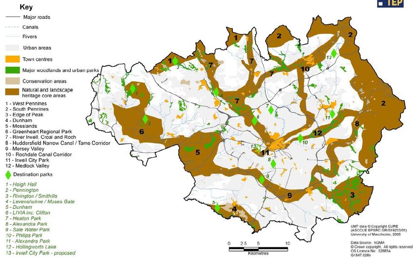
2.3 Flood Risk and Green Infrastructure
The Green Infrastructure (GI) of Manchester, Salford and Trafford is part of the districts'
life support system. It is a planned and managed network of natural environmental
components and green spaces that intersperse and connect the urban centres, suburbs
and rural fringe consisting of:
● Open Spaces – parks, woodlands, nature reserves, lakes
● Linkages – River corridors and canals, pathways and cycle routes and greenways
● Networks of “urban green” – private gardens, street trees, verges and green roofs
With regards to flood risk, green spaces can be used to manage storm flows and free up
water storage capacity in existing infrastructure to reduce risk of damage to urban
property, particularly in city centres and vulnerable urban regeneration areas. GI can also
improve accessibility to waterways and improve water quality, supporting regeneration and
improving opportunity for leisure, economic activity and biodiversity.
Towards a Green Infrastructure Framework for Greater Manchester (September 2008)
was published by TEP for AGMA and Natural England on the feasibility of a GI framework
for Greater Manchester. Figure 2-5 is an extract of the Summary Report illustrating the
broad GI network in Greater Manchester. Figure 2-6 shows the GI in relation to flood risk
areas.
2009s0290 Final MST SFRA User Guide May 2010.docx 13GI should be incorporated into master planning and individual sites where practicable, directed by the need to retain exceedance flood paths and natural attenuation of flood flows. The evidence provided in the MST Level 1 and Level 2 SFRA should be used to enhance Towards a Green Infrastructure Framework for Greater Manchester by identifying opportunities for delivering FRM measures through GI. River corridors identified as functional floodplain are an excellent linkage of GI and can provide storage during a flood event. Areas that either suffer from, or contribute to, critical surface water flooding problems should be incorporated into council GI strategies. Opening up land to create flow paths or flood storage areas can help protect current and future developments. 2009s0290 Final MST SFRA User Guide May 2010.docx 14
Figure 2-5: Green Infrastructure and District Places – Key Diagram

2009s0290 Final MST SFRA User Guide May 2010.docx                                              15
Figure 2-6: Green Infrastructure in a changing climate

2009s0290 Final MST SFRA User Guide May 2010.docx                                                            16
2.4   Liaison between services
      Given the cross cutting nature of flooding, it is essential that effective communication
      protocols and working arrangements at both a District and at a GM level are developed
      and maintained. The linkages between Policy Planning and Development Control are well
      established, but between Policy Planning, Emergency Planning and Drainage Engineering
      they are less so. Engagement with external stakeholders such as the Environment
      Agency, United Utilities, British Waterways and the Manchester Ship Canal Company, as
      well as the emergency services, should also be included as appropriate.
      Planning policy should have regard to flood warning and evacuation plans prepared by
      Emergency Planners at different spatial levels.
      It may be useful to consider how key parts of agreed flood evacuation plans could be
      incorporated within LDFs, including in terms of protecting evacuation routes and assembly
      areas from inappropriate development.

      2009s0290 Final MST SFRA User Guide May 2010.docx                                           17
3 Guidance for Development Control
The aim of this section is to provide guidance on the use of the SFRA by Development Control
officers. When it comes to individual planning applications, Planners should use the guidance in
this SFRA User Guide, PPS25 and its Practice Guide to:
Check whether the Sequential Test and/or the Exception Test have already been
applied
o Refer developer to LDD and supporting evidence to identify if the Sequential
Test has been applied and development is likely to pass the Exception Test –
site may have already been assessed
o If evidence is available, the Sequential Test and likelihood of passing the
Exception Test have been assessed. If no evidence is available, developers
must apply the Sequential and Exception Tests – move on to the next stage
Refer developer to the following in order for them to apply the Sequential for all
sites and Exception Tests where necessary
o Manchester City, Salford City and Trafford Councils Level 1 SFRA to inform
Sequential Test
o Sequential Test Spreadsheet to compare similar sites assessed
o Manchester City, Salford City and Trafford Councils Level 2 SFRA to inform the
likelihood of passing the Exception Test
o Manchester City, Salford City and Trafford Councils SFRA maps to review
scale and nature of flood risk
o Manchester City, Salford City and Trafford Councils SFRA maps to identify
residual risks
Consult with Environment Agency and other relevant stakeholders to
o Assess flood risk constraints identified on site using the Manchester City,
Salford City and Trafford Councils Level 2 Hybrid SFRA
Scope an appropriate FRA
o What is the scale and nature of risk from all sources?
o Is there coherence in terms of assumptions / scenarios - conflict must be
avoided
o Does the site lie within a CDA identified in the Level 2 SFRA Section 5?
o Refer developers to Section 3, 4 and 5 of this SFRA User Guide
Consult with Environment Agency over FRA acceptance/approval
2009s0290 Final MST SFRA User Guide May 2010.docx 183.1 Introduction
The LPA are the principal decision-makers on applications for new development. This is
carried out through Development Control. Whilst it is the overall responsibility of the
developer to carefully consider flood risk issues regarding their proposed development
site, the LPA should be involved at the earliest possible stage during pre-application
discussions. For all planning applications, Development Control planners should consult
appropriate drainage colleagues to assess whether there are flooding problems in addition
to those picked up by the Environment Agency, United Utilities or the SFRA. Discussions
with Planning Policy colleagues should also take place.
Development proposals should be supported by a coherent FRA which meets the
requirements of PPS25, and has full regard to the hybrid Level 2 SFRA. Consistent
assumptions and modelled scenarios for hydraulically linked watercourses in all FRAs will
be necessary to develop a robust and coherent approach across the three authorities;
cumulative impacts should also be considered. The three Local Authorities and the
Environment Agency should be mindful of a developer (or different developers) seeking to
use certain assumptions/ scenarios for one location, and different scenarios and
assumptions for another location, to support development proposals. The potential for
conflict between assumptions/ scenarios for different locations should be recognised and
the implications of different assumptions/ scenarios for not only the development location,
but also elsewhere along the watercourse.
Development Control officers must always consider development from a strategic
view point and the cumulative effect of all proposed development taking place, even
though applications for developments are submitted at a site level. It should not be
presumed that flood risk has been fully addressed at a strategic high level - site
specific Flood Risk Assessments will be required, in line with national policy, and
applications should be considered within the context of a wider flood risk
management strategy for an area.
3.2 The Sequential Test and Exception Test
Development proposals for allocated sites will have been sequentially appraised.
However, developers should apply the sequential approach to site layout when matching
land use vulnerability to flood risk areas within allocated sites, as described in PPS25. The
LPA will then consider whether this passes the Exception Test.
However, where a site has not been identified within a Sequentially Tested LDD, the
Sequential Test will need to be applied i.e. the developer will need to provide evidence to
the LPA that there are no other reasonable available sites where the development could
be located. The LPA will then use this information to apply the Sequential Test. This
particularly applies to Windfall Sites that have not been allocated in the LDF.
Development Control officers should refer to Section 2 of this report for guidance on
applying the Sequential and Exception Tests. Developers will need to provide evidence
that the Exception Test can be passed where relevant. This will be needed for allocated
and windfall sites, if required according to the vulnerability of the proposed land use, and
the risk of flooding. Development Control officers will then need review the evidence
provided and decide whether a site passes the Exception Test.
Some locations may require a strategic approach when it comes to planning development,
due to the possibility of large off site impacts caused by piecemeal development. This is
one of the reasons why clear and robust cross-boundary working arrangements are
needed to effectively manage risk.
PPS25 Practice Guide Section 4.23 to 4.45 provides more detail and a recommended
approach on how to apply the Sequential Test and Exception Test to individual planning
applications, windfall sites, existing and single properties and changes of use and must be
referred to.
2009s0290 Final MST SFRA User Guide May 2010.docx 19Table 3-1: Development types and application of Sequential and Exception Tests
Development Sequential Who Applies the Exception Test Who Applies the
Test Sequential Test? Required? Exception Test?
Required
Allocated Sites No LPA should have Dependent on LPA to advise
already carried land use on the likelihood
out the test vulnerability of test being
during the passed. But the
allocation of developer must
development provide
sites within their evidence that
LDD the test can be
passed by
providing
planning
justification and
producing a
detailed FRA
Windfall Sites Yes Developer Dependent on Developer must
provides land use provide
evidence that the vulnerability evidence that
test can be the test can be
passed to the passed by
LPA. An area of providing
search to be planning
agreed within justification and
the local producing a
4
authority area . detailed FRA
Regeneration Sites No - Dependent on LPA to advise
Identified Within land use on the likelihood
LDD vulnerability of test being
passed. But the
developer must
provide
evidence that
the test can be
passed by
providing
planning
justification and
producing a
detailed FRA
Renewable Energy No PPS22 Dependent on LPA to advise
Projects Renewable land use on the likelihood
Energy advises vulnerability. of passing test.
the LPA not to But the
use a sequential developer must
approach in the provide
consideration of evidence that
such proposals the Test can be
passed by
providing
planning
justification and
producing a
detailed FRA.
4
Whilst PPS25 recognises that the Sequential Test should be applied to a whole LPA area, it is recognised that
Local Authority Core Strategies seek to allocate development in communities and a pragmatic approach to
undertaking the Sequential Test should be agreed with the LPA and the EA regarding the area of search. This
may be restricted to communities or wards if justified.
2009s0290 Final MST SFRA User Guide May 2010.docx 20Development Sequential Who Applies the Exception Test Who Applies the
Test Sequential Test? Required? Exception Test?
Required
Part B of the
Exception Test
may not apply in
accordance with
PPS22.
Redevelopment of No - Dependent on Developer must
Existing Single land use provide
Properties vulnerability evidence that
the test can be
passed by
providing
planning
justification and
producing a
detailed FRA
Changes of Use No - Dependent on Developer must
land use provide
vulnerability evidence that
the test can be
passed by
providing
planning
justification and
producing a
detailed FRA
3.3 Supporting the FRA Process
Certain types of development and development in certain areas must be supported by an
appropriate site-specific FRA in accordance with the guidance provided in PPS25 Practice
Guide Section 3.80 to 3.90.
Site specific Flood Risk Assessments (FRAs) are prepared by those proposing
development. The principal aims of a FRA are to determine the acceptable management
of flood risk to the development proposal itself and any impacts elsewhere, and to ensure
that the development and its users/occupants remain safe in times of flood. The
Developer should consult the LPA and the Environment Agency (and other relevant flood
risk consultees, such as United Utilities, the Manchester Ship Canal Company or British
Waterways), to identify known flood-related site constraints and agree the scope of an
appropriate FRA.
This should meet the requirements of PPS25, and have full regard to the hybrid Level 2
SFRA, particularly in terms of hydraulically linked watercourses and the scope for
cumulative impacts across the three authorities and beyond. The three Local Authorities
and the Environment Agency should be mindful of a developer (or different developers)
seeking to use certain assumptions/ scenarios for one location, and different scenarios
and assumptions for another location, to support development proposals. The potential
for conflict between assumptions/ scenarios for different locations should be recognised
and the implications of different assumptions/ scenarios for not only the development
location, but also elsewhere along hydraulically linked watercourses, considered.
There are three levels of FRA:
● Level 1- Screening study, to identify whether there are any flooding or surface
water management issues that need to be considered further
2009s0290 Final MST SFRA User Guide May 2010.docx 21You can also read