The Hive Kelham Island Sheffield - Historic Environment Desk-based Assessment including Historic Buildings Appraisal - Planning Alerts | UK
←
→
Page content transcription
If your browser does not render page correctly, please read the page content below
The Hive
          Kelham Island
            Sheffield
Historic Environment Desk-based Assessment
     including Historic Buildings Appraisal

          Document Ref.: 242400.02
              February 2021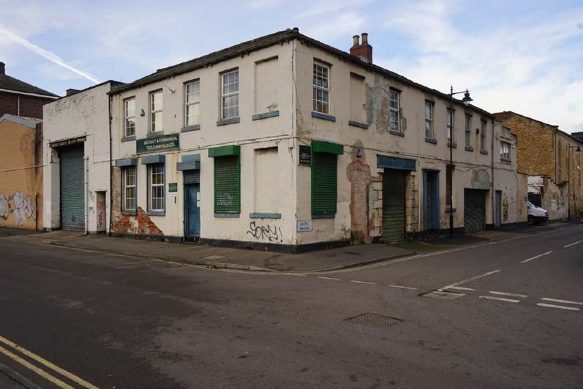
© Wessex Archaeology Ltd 2021, all rights reserved

Unit R6
Sheaf Bank Business Park
Prospect Road
Sheffield
S2 3EN

www.wessexarch.co.uk

Wessex Archaeology Ltd is a company limited by guarantee registered in England, company number 1712772. It is also a
Charity registered in England and Wales number 287786, and in Scotland, Scottish Charity number SC042630. Our
registered office is at Portway House, Old Sarum Park, Salisbury, Wiltshire, SP4 6EB.

Disclaimer
The material contained in this report was designed as an integral part of a report to an individual client and was prepared
solely for the benefit of that client. The material contained in this report does not necessarily stand on its own and is not
intended to nor should it be relied upon by any third party. To the fullest extent permitted by law Wessex Archaeology will
not be liable by reason of breach of contract negligence or otherwise for any loss or damage (whether direct indirect or
consequential) occasioned to any person acting or omitting to act or refraining from acting in reliance upon the material
contained in this report arising from or connected with any error or omission in the material contained in the report. Loss
or damage as referred to above shall be deemed to include, but is not limited to, any loss of profits or anticipated profits
damage to reputation or goodwill loss of business or anticipated business damages costs expenses incurred or payable to
any third party (in all cases whether direct indirect or consequential) or any other direct indirect or consequential loss or
damage.

Document Information
Document title                   The Hive, Kelham Island, Sheffield
Document subtitle                Historic Environment Desk-based Assessment including Historic
                                 Buildings Appraisal
Document reference               242400.2

Commissioned by                  Grantside Ltd
Address                          Middlethorpe Manor
                                 York
                                 YO23 2QB
National grid reference          435080, 388019

Project management by            Mark Turner
Document compiled by             Andrew Reid/Seth Price

Quality Assurance
Issue and date            Status                             Author   Approved by
1     05/01/2021          First Internal Draft               AR/SP

                                                                                     AR
2     22/01/2021          Second Internal Draft              AR/SP
                                                                                         LEM
3     04/02/2021          External Draft                     AR/SP
                                                                                    MT
The Hive, Kelham Island, Sheffield
Historic Environment Desk-based Assessment including Historic Buildings Appraisal
Contents
Summary........................................................................................................................................... iv
Acknowledgements ............................................................................Error! Bookmark not defined.
1 INTRODUCTION ......................................................................................................................1
1.1 Project background .........................................................................................................1
1.2 Development proposals ...................................................................................................1
1.3 Aims and purpose of the assessment .............................................................................1
2 METHODOLOGY .....................................................................................................................2
2.1 Introduction ......................................................................................................................2
2.2 Study Area .......................................................................................................................2
2.3 Sources ...........................................................................................................................2
2.4 Site visit ...........................................................................................................................2
2.5 Assessment of significance .............................................................................................3
2.6 Setting assessment .........................................................................................................3
2.7 Assumptions and limitations ............................................................................................4
2.8 Copyright .........................................................................................................................5
3 BASELINE RESOURCE ..........................................................................................................5
3.1 Introduction ......................................................................................................................5
3.2 Site description ................................................................................................................5
3.3 Designated heritage assets .............................................................................................5
3.4 Historical and archaeological background .......................................................................6
4 ARCHAEOLOGICAL INTEREST AND SIGNIFICANCE .........................................................9
4.1 Potential impact ...............................................................Error! Bookmark not defined.
4.2 Conditions for survival .....................................................Error! Bookmark not defined.
4.3 Interest and significance ..................................................................................................9
5 BUILT HERITAGE..................................................................................................................10
5.1 Introduction ....................................................................................................................10
5.2 2-4 South Parade ..........................................................................................................11
5.3 Kelham Island Conservation Area .................................................................................14
6 SETTING ASSESSMENT ......................................................................................................16
6.1 Introduction ....................................................................................................................16
6.2 Scoping exercise (Step 1) .............................................................................................16
6.3 Setting – (Steps 2 and 3) ...............................................................................................17
6.4 William Brothers of Sheffield (NHLE 1247393) .............................................................17
6.5 Crucible Workshop at Former Williams Brothers (NHLE 1392551)...............................18
6.6 The Fat Cat (NHLE 1388269) .......................................................................................19
7 CONCLUSIONS .....................................................................................................................20
REFERENCES ................................................................................................................................23
Bibliography ............................................................................................................................23
Site and Monuments Records ................................................................................................24
Cartographic and documentary sources (accessed online)....................................................24
Online resources.....................................................................................................................24
APPENDICES ....................................................................................................................................II
Appendix 1: Terminology ..........................................................................................................II
Appendix 2: Legislative and planning framework ....................................................................III
Appendix 3: Gazetteer ............................................................................................................ VI
i
Doc ref 242400.02
Issue 3, Feb 2021The Hive, Kelham Island, Sheffield
Historic Environment Desk-based Assessment including Historic Buildings Appraisal
Figures
Figure 1 Site location and key designated heritage assets
Figure 2 Site and relevant SMR entries identified in text
Figure 3 Site and previous excavations in the surrounding area
Figure 4 1894 Ordnance Survey Map
Figure 5 1924 Ordnance Survey Map
Figure 6 1974 Ordnance Survey Map
Figure 7 2-4 South Parade Phased Plan
Plates
Plate 1 Southeast and northeast elevations of 2-4 South Parade, from the junction of South
Parade and Bowling Green Street
Plate 2 Northeast elevation of 2-4 South Parade, with the roof line of the northern range to the
building visible to the top right, facing southeast from South Parade
Plate 3 View to the southeast elevation of 2-4 South Parade along Bowling Cross Street from
the south
Plate 4 View of modern opening to the rear elevation of the South Parade range from within
the Site, facing northeast. Note the modern stud wall elements dividing the interior of
the building.
Plate 5 View of modern kitchen extension to the rear of the Bowling Green Street range, facing
southwest.
Plate 6 Southeast elevation of the northern range from within the Site – note the blocked
windows to the ground floor and extant timber sash windows to first floor.
Plate 7 Lobby and main stair within the Bowling Green Street range ground floor, facing
northwest
Plate 8 Reception, ground floor of Bowling Green Street range, facing west
Plate 9 Office, ground floor of Bowling Green Street range, facing northeast
Plate 10 Office, first floor of Bowling Green Street range, facing northeast
Plate 11 Kitchen, with modern store beyond, first floor of Bowling Green Street range, facing
northwest
Plate 12 Bedroom, first floor of Bowling Green Street range, facing west
Plate 13 Original window architrave to the first-floor bedroom, Bowling Green Street range,
facing southeast
Plate 14 Garage, ground floor South Parade range, facing north
Plate 15 Welding shop, ground floor South Parade range, facing north
Plate 16 Welding shop, ground floor South Parade range, facing east
Plate 17 Toilets, ground floor South Parade range, facing north
Plate 18 Staircase accessing first floor of the South Parade range and north range, north range,
facing northwest
Plate 19 Timber-framed sash to former courtyard, stairwell landing, north range, facing
southeast
Plate 20 Storage room, first floor South Parade range, facing southeast
Plate 21 Workshop, first floor north range, facing south – note original sash windows
Plate 22 Surviving walls to an earlier structure within the centre of the Site – note the inserted
openings (left) and truncated brickwork (centre)
Plate 23 Surviving walling pertaining to previous structures within the centre of the Site
Plate 24 View to the Site looking northwest, emphasising the poor character and appearance of
the area to the southeast of the Site.
Plate 25 View to the Site from the south – note the scale and character of the surrounding
development in comparison with that within the Site
Plate 26 Character of development to the north of the Site, facing northeast along Ebenezer
Place
ii
Doc ref 242400.02
Issue 3, Feb 2021The Hive, Kelham Island, Sheffield
Historic Environment Desk-based Assessment including Historic Buildings Appraisal
Front cover
View of 2-4 South Parade
iii
Doc ref 242400.02
Issue 3, Feb 2021The Hive, Kelham Island, Sheffield
Historic Environment Desk-based Assessment including Historic Buildings Appraisal
Summary
Wessex Archaeology were commissioned by Grantside Ltd to prepare a Historic Environment Desk-
based Assessment for a parcel of land situated off Bowling Green Street, Sheffield, South Yorkshire.
The report is intended to inform the design process and to be submitted as part of the planning
application for the construction of a new five-storey building.
This report provides an assessment of the historic environment considerations of the proposed
development and includes a historic buildings appraisal of 2-4 South Parade which has been
identified as a non-designated heritage asset and are located within the Kelham Island Conservation
Area.
There is an archaeological interest within the site which is characterised as a very high potential for
encountering the remains of former 19th century buildings visible on historic mapping with a low
potential for earlier remains due to disturbance from development. While further assessment in the
form of intrusive excavation is likely to be required, there are no indications that, if present, the
archaeological resource within the site would be so complex, rare, and well-preserved so as to
elevate its significance and preclude development therein. The details of any further works should
be agreed in consultation with the Principal Archaeologist for South Yorkshire Archaeology Service.
2-4 South Parade derives its significance primarily from its historic interest, being illustrative of the
once large and common place Sheffield steel and cutlery manufacturing industry in the Kelham
Island area, and forming part of the former Ashberry Metal Works. It has some architectural interest
also, albeit reduced by unsympathetic repair and alteration. The physical fabric of the building
provides evidence of its past use, development and architectural features associated with 19th-
century industry, contributing to its archaeological interest. Similarly, the limited structural remains
within the centre of the Site have some historic and archaeological interest, attesting to the past
character and function of the Site as a whole.
2-4 South Parade is a non-designated heritage asset and its demolition will result in a total loss of
its significance. This total loss will equate to harm in line with the criteria set out in paragraph 197 of
NPPF. This loss should form part of a balanced judgement where the benefits of the proposed
development should be taken into account when determining an application where harm will occur
to a non-designated heritage asset.
The loss of 2-4 South Parade could be partially offset through a programme of building recording.
2-4 South Parade makes a contribution to significance of the Conservation Area through both its
character and appearance, while the remainder of the site does not. This contribution is, however,
limited by its stilted appearance within the surrounding later 20th century and early 21st century
townscape which serves to sever any consistent appearance of historic value.
Its loss will therefore lead to harm on a designated heritage asset, which has been assessed as less
than substantial as the significance embroiled in its character will still be appreciable through the
larger works buildings and river views as set out above. That less than substantial harm should be
weighed against the public benefits of the proposal as set out within paragraph 195 of NPPF.
The construction of the proposed development will not have an effect on the character or appearance
of the Conservation Area. The recent development undertaken within the past 20 years has
dramatically altered the character and appearance with a further addition on its southern edge away
from the core areas of significance will not lead to an appreciable change and thus, will not lead to
any harm to its significance.
iv
Doc ref 242400.02
Issue 3, Feb 2021The Hive, Kelham Island, Sheffield
Historic Environment Desk-based Assessment including Historic Buildings Appraisal
The settings assessment considered designated heritage assets within a 1 km study area which had
the potential for their identified significance to be impacted through a change in their setting. Scoping
identified three assets which required further assessment, the Grade II listed William Brothers of
Sheffield (a former chapel and Sunday school), the Grade II listed Crucible Workshop at Former
Williams Brothers and the Grade II listed Fat Cat public house. Other assets were scoped out as the
site does not lie within their setting or make any meaningful contribution to their significance; the
significance of these assets will not be effected by the proposed development.
The assessment identified that the Site does not lie within the setting of any of these assets which
makes a contribution to their significance and therefore the introduction of a new modern
development will not change how these assets are appreciated.
Similarly, as the non-designated asset 2-4 South Parade makes no discernible contribution to the
significance of these assets and its removal will not alter how any of the designated assets are
understood as remaining elements of the former landscape.
v
Doc ref 242400.02
Issue 3, Feb 2021The Hive, Kelham Island, Sheffield
Historic Environment Desk-based Assessment including Historic Buildings Appraisal
The Hive
Kelham Island
Sheffield
Historic Environment Desk-Based Assessment
including Historic Buildings Appraisal
1 INTRODUCTION
1.1 Project background
1.1.1 This Historic Environment Desk-based Assessment (HEDBA) was commissioned by
Grantside Ltd to assess the potential impact to the historic environment resource from a
new development on a parcel of land situated off Bowling Green Street, Sheffield, South
Yorkshire centred on National Grid Reference (NGR) 435080, 388019 (hereafter ‘the Site’;
Figure 1).
1.1.2 This study seeks to inform the design process and will be submitted as part of the planning
application.
1.2 Development proposals
1.2.1 At the time of writing, development proposals set out the construction of a new five-storey
building arranged around an internal courtyard which would necessitate the demolition of
all existing structures within the Site.
1.2.2 The proposals seek to respect the historic development of the area by mimicking the
traditional courtyard layout of the former steel and metal trades industries in Sheffield, whilst
using masonry from the existing buildings to incorporate into the design to provide a strong
link to the former character of the area.
1.3 Aims and purpose of the assessment
Introduction
1.3.1 The purpose of this assessment is to comply with the appropriate assessment planning
guidance as outlined in paragraph 189 of the National Planning Policy Framework (NPPF),
2019 and in line with CIfA Guidance Standards and Guidance (2020). This assessment will
also identify and reference any other relevant and/or appropriate documents such as
existing heritage or archaeological site management plans that may be in operation in the
locality.
Aim
1.3.2 This report will determine, as far as is reasonably possible from existing records, the nature,
extent and significance of the historic environment within a specified area. The desk-based
assessment will be undertaken using appropriate methods and practices which satisfy the
stated aims of the project, and which comply with the Code of Conduct and other relevant
regulations of the Chartered Institute for Archaeologists. Historic Environment here includes
archaeological remains as well as built heritage assets.
1.3.3 This report will establish the impact of the proposed development on the significance of the
historic environment or will identify the need for further evaluation to do so and will enable
reasoned proposals and decisions to be made to mitigate, offset or accept without further
intervention that impact.
1
Doc ref 242400.02
Issue 3, Feb 2021The Hive, Kelham Island, Sheffield
Historic Environment Desk-based Assessment including Historic Buildings Appraisal
2 METHODOLOGY
2.1 Introduction
2.1.1 The methodology employed during this assessment was based upon relevant professional
guidance, including the Chartered Institute for Archaeologists' Standard and guidance for
historic environment desk-based assessment (CIfA 2020).
2.2 Study Area
2.2.1 Baseline conditions were established through a desk-based review of publicly accessible
sources of primary and synthesised information pertaining to the historic environment within
a 500 m radial Study Area. The recorded historic environment resource within the Study
Area was considered to provide a context for the discussion and interpretation of the known
and potential historic environment resource (heritage assets) that could be affected by the
proposed development, via the application of informed professional judgement.
2.3 Sources
2.3.1 The following publicly accessible sources of primary and synthesised information were
consulted:
• the National Heritage List for England (NHLE), which is the only official and up to date
database of all nationally designated heritage assets;
• the South Yorkshire Sites and Monuments Record (SYSMR), comprising a database
of recorded archaeological sites, find spots, and archaeological events within the
county;
• relevant national, regional and thematic Research Frameworks;
• national heritage datasets including the Archaeological Data Service (ADS), Heritage
Gateway, OASIS, PastScape and the National Record of the Historic Environment
(NRHE) Excavation Index;
• historic manuscripts, surveyed maps, and Ordnance Survey maps; and
• relevant primary and secondary sources, including published and unpublished
archaeological reports relating to excavations and observations in the vicinity of the
Site.
2.3.2 Sources consulted during the preparation of this assessment are listed in the References
section at the end of this report. All records obtained from the NHLE and SYSMR are listed
in Appendix 3 and those key to the assessment are illustrated in Figures 1, 2 and 3.
2.3.3 This report was written during a period of national lockdown to slow the spread of
coronavirus. All local archives, record offices and the SYSMR were closed in accordance
with Covid-19 regulations. To comply with government requirements, all sources within this
document have been obtained from online repositories, or Wessex Archaeology’s in-house
collection.
2.4 Site visit
2.4.1 The Site was visited on the 11th January 2021 with internal access gained to 2-4 South
Parade. Site conditions are summarised below (see Section 3.1).
2
Doc ref 242400.02
Issue 3, Feb 2021The Hive, Kelham Island, Sheffield
Historic Environment Desk-based Assessment including Historic Buildings Appraisal
2.4.2 The aim of the Site visit was to assess the general aspect, character, condition and setting
of the Site and to identify any prior impacts not evident from secondary sources. The Site
visit also sought to ascertain if the Site contained any previously unidentified features of
archaeological, architectural or historic interest.
2.4.3 A key objective of the Site visit was the gathering of observations upon which to assess the
potential for the development proposals to change the settings of heritage assets (see
Section 6).
2.5 Assessment of significance
2.5.1 National Planning Policy Framework (NPPF) defines significance as: the value of a heritage
asset to this and future generations because of its heritage interest. The interest may be
archaeological, architectural, artistic or historic. Significance derives not only from a
heritage asset's physical presence, but also from its setting. For World Heritage Sites, the
cultural value described within each site's Statement of Outstanding Universal Value forms
part of its significance.
2.5.2 Current national guidance for the assessment of the significance of heritage assets is based
on criteria provided by Historic England in Conservation Principles, Policies and Guidance
for the Sustainable Management of the Historic Environment (English Heritage 2008).
Within the guidance, significance is weighed by consideration of the potential for the asset
to demonstrate differing 'values'.
2.5.3 These values are broadly analogous to the 'interests' defined by NPPF, which are used
within this report, as per Statements of Heritage Significance: Analysing Significance in
Heritage Assets (Historic England 2019). These are:
• Archaeological Interest: there will be archaeological interest in a heritage asset if it
holds, or potentially holds, evidence of past human activity worthy of expert
investigation at some point.
• Architectural and Artistic Interest: these are interests in the design and general
aesthetics of a place. They can arise from conscious design or fortuitously from the
way the heritage asset has evolved. More specifically, architectural interest is an
interest in the art or science of the design, construction, craftsmanship and
decoration of buildings and structures of all types. Artistic interest is an interest in
other human creative skill, like sculpture.
• Historic Interest: An interest in past lives and events (including prehistoric). Heritage
assets can illustrate or be associated with them. Heritage assets with historic
interest not only provide a material record of our nation's history but can also provide
meaning for communities derived from their collective experience of a place and can
symbolise wider values such as faith and cultural identity.
2.5.4 This assessment was also informed by the advice published by Historic England in the
document entitled Managing Significance in Decision-Taking in the Historic Environment:
Good Practice Advice in Planning Note 2 (2015).
2.6 Setting assessment
2.6.1 Annex 2 of the NPPF defines the setting of a heritage asset as:
3
Doc ref 242400.02
Issue 3, Feb 2021The Hive, Kelham Island, Sheffield
Historic Environment Desk-based Assessment including Historic Buildings Appraisal
'the surroundings in which a heritage asset is experienced. Its extent is not fixed and may
change as the asset and its surroundings evolve. Elements of a setting may make a positive
or negative contribution to the significance of an asset, may affect the ability to appreciate
that significance or may be neutral.'
2.6.2 The setting assessment was guided by The Setting of Heritage Assets: Historic
Environment Good Practice Advice in Planning Note 3 (GPA 3; Historic England 2017),
which states that:
'Setting is not itself a heritage asset, nor a heritage designation, although land comprising
a setting may itself be designated…. Its importance lies in what it contributes to the
significance of the heritage asset or to the ability to appreciate that significance.' (GPA 3,
para. 9)
2.6.3 When undertaking settings assessment, intervisibility between the development and a
heritage asset does not, in and off itself, constitute an adverse effect to significance. A
specific adverse effect on the significance of an asset, occurring as a result of changes
within its setting, must be identified in order for 'harm' to be deemed to occur.
2.6.4 GPA3 advocates a systematic and staged approach to the assessment of the effects of
development:
• Step 1 of the approach is to 'identify which heritage assets and their settings are
affected'
• Step 2 requires assessment of 'the degree to which these settings and views make a
contribution to the significance of the heritage asset(s) or allow significance to be
appreciated'
• Step 3 is to 'assess the effects of the proposed development, whether beneficial or
harmful, on the significance or on the ability to appreciate it'
• Step 4 is to explore ways to 'maximise enhancement and avoid or minimise harm'
• Step 5 is to 'make and document the decision and monitor outcomes'
2.6.5 For the purposes of this assessment, only Steps 1-4 of the process have been followed.
2.7 Assumptions and limitations
2.7.1 Data used to compile this report consists of secondary information derived from a variety of
sources, only some of which have been directly examined for the purposes of this Study.
The assumption is made that this data, as well as that derived from other secondary
sources, is reasonably accurate.
2.7.2 The records held by the SYSMR are not a record of all surviving heritage assets, but a
record of the discovery of a wide range of archaeological and historical components of the
historic environment. The information held within it is not complete and does not preclude
the subsequent discovery of further elements of the historic environment that are, at
present, unknown.
4
Doc ref 242400.02
Issue 3, Feb 2021The Hive, Kelham Island, Sheffield
Historic Environment Desk-based Assessment including Historic Buildings Appraisal
2.8 Copyright
2.8.1 This report may contain material that is non-Wessex Archaeology copyright (e.g., Ordnance
Survey, British Geological Survey, Crown Copyright), or the intellectual property of third
parties, which Wessex Archaeology are able to provide for limited reproduction under the
terms of our own copyright licences, but for which copyright itself is non-transferable by
Wessex Archaeology. Users remain bound by the conditions of the Copyright, Designs and
Patents Act 1988 with regard to multiple copying and electronic dissemination of the report.
3 BASELINE RESOURCE
3.1 Introduction
3.1.1 The following section provides a summary of the recorded historic environment within the
Study Area, compiled from the sources summarised above and detailed in the references
section of this report. The aim is to identify the known and potential components of the
historic environment (heritage assets) that could be affected by the proposed development.
3.1.2 All heritage assets identified within the Study Area are listed in Appendix 3 with those
relevant to the assessment shown referenced in the text below.
3.2 Site description
3.2.1 The Site is located within the Kelham Island area of Sheffield, approximately 700 m to the
north-east of the city centre (Figure 1).
3.2.2 The Site is approximately 0.12 ha in size and is situated at an elevation of approximately
60 m above Ordnance Datum (aOD).
3.2.3 The Site is underlain by a solid bedrock geology comprising the Pennine Lower Coal
Measures Formation which is overlain by superficial deposits of alluvium from the nearby
River Don which covered all but the southern corner of the Site (British Geological Survey
online).
3.3 Designated heritage assets
3.3.1 The northern section of the Site is located within the Kelham Island Conservation Area,
although there are no designated heritage assets within the Site (Figure 1).
3.3.2 The closest designated heritage asset is the Grade II listed Williams Brothers of Sheffield
(NHLE no. 1247393; Figure 1) which is an early 19th century Wesleyan Methodist Chapel
with a later 19th century adjoining Sunday school. The building was later taken over by the
expanding Williams Brothers industrial works which used the building as a warehouse until
1997, hence the naming on the NHLE.
3.3.3 Within the surrounding area there are a number of other designated heritage assets
including the Grade II listed Crucible Workshop at Williams Brothers (NHLE no. 1392551),
the Grade II* listed Entrance Gateway to Green Lane Works (NHLE no. 1255044), the
Grade II* listed Globe Works (NHLE no. 1271128) and the Scheduled and Grade II listed
Cementation Furnace (NHLE no. 1004791 & 1247524).
5
Doc ref 242400.02
Issue 3, Feb 2021The Hive, Kelham Island, Sheffield
Historic Environment Desk-based Assessment including Historic Buildings Appraisal
3.4 Historical and archaeological background
Prehistoric (970,000 BC–AD 43) to Romano-British (AD 43–410)
3.4.1 There are no finds or features dating from the prehistoric or Romano-British periods
recorded by the SMR within the Site or Study Area and there is limited evidence for
prehistoric activity within the area around Sheffield City Centre.
3.4.2 The Roman fort at Templeborough, Rotherham was constructed in c. AD 50 and is the
closest known area of settlement to the Site during the Romano-British period. The route of
a Roman road is recorded as running through the city to Templeborough from Brough in
Derbyshire, although no evidence for the road has ever been identified within Sheffield City
Centre.
Anglo-Saxon (AD 410–1066) and medieval (AD 1066–1500)
3.4.3 The settlement at Sheffield is recorded in the Domesday Book as a being quite small in size
(opendomesday.org), However, its inclusion in the Domesday Book, which was the record
of a survey of taxable assets carried out following the Norman Conquest of 1066, indicates
its establishment some time prior to this. Its name is derived from a combination of two Old
English words, ‘Sheaf’ meaning a boundary, and ‘feld’, meaning open country (University
of Nottingham 2021).
3.4.4 Sheffield Castle was originally constructed in the early 12th century on top of the purported
site of a three-bayed timber building which formed the administrative centre for the Anglo-
Saxon settlement (Hey 1979). The Castle was destroyed in 1266 and later rebuilt in 1270
by Thomas de Furnival who was also responsible for establishing the settlement’s
marketplace (ibid.).
3.4.5 There are no finds or features recorded by the SMR within the Site or Study Area which
date to the Anglo-Saxon or medieval period. Later cartographic evidence indicates this area
formed part of the agricultural hinterland for the settlement at Sheffield which was centred
around the Castle, Cathedral and market located approximately 750 m south-east of the
Site.
Post-medieval (AD 1500–1800)
3.4.6 Industry in Sheffield is recorded as far back as the 13th century, although it is likely to be
much earlier as it was already a noted location for knife manufacturing (Hey 2005, 17). The
growth of industry was largely due to the presence of fiver rivers which were used to power
works via water wheels as well as the transportation of goods in and out (Hey 1991).
3.4.7 The primary metal worked in Sheffield was steel which was being formed in cementation
furnaces in the 17th and 18th centuries, although this production technique was inefficient
and led to steel of varying quality. The steel was mainly used in the production of cutlery
and by the middle of the 17th century, Sheffield had a highly specialised workforce with
three out of five men working within the cutlery industry (Hey 2005, 60). By the 18th century,
Sheffield was at the forefront of technological advances in steel production which included
the invention of the process to create crucible steel by Benjamin Huntsman. Steel produced
in the crucible furnaces was of significantly better quality than that previously produced
using the cementation process.
3.4.8 The former sites of the purported first cementation furnace (SMR ref. 05537; Figure 2),
which was in place by 1716, and possibly the first crucible furnace (05759), in operation
from 1760, in Sheffield are both located within the Study Area, approximately 230 m south-
east and 50 m south of the Site respectively. The presence of the early 18th century
6
Doc ref 242400.02
Issue 3, Feb 2021The Hive, Kelham Island, Sheffield
Historic Environment Desk-based Assessment including Historic Buildings Appraisal
cementation furnace is thought to have led to the naming of its surrounding area as
‘Furnace Hill’.
3.4.9 The focus of steel production was along the banks of the River Don immediately to the north
of the main settlement centre, which included the Kelham Island Area. However, the initial
development of Kelham Island was much earlier and came in the form of corn and textile
mills with the first reference made to the Kelham grinding wheel and mill (01691/01; Figure
2) in 1604. Documentary evidence suggests that this original wheel was destroyed in the
1650s, and later rebuilt.
3.4.10 The area continued to see this kind of development with the Kelham Mill (01690/01; Figure
2) constructed in 1758 which was initially used for silk production before being converted
into a cotton mill (01691/02) in the late 18th century. The mill went on to become the Poor
House in the early 19th century before being converted back to a corn mill (01690/03) in
1864. The mill was demolished in 1946.
3.4.11 Beyond Furnace Hill to the south, the settlement at Sheffield began to develop beyond its
medieval extent in the mid-17th century into the area known as “The Crofts” which extended
to Upper Allen Street (Belford 2001). By the 18th century, the Crofts was a densely packed
area with a range of industrial activities being undertaken as well as being used for housing
(ibid.). Recent excavations at Hollis Croft (Wessex Archaeology 2017; Figure 3), located
approximately 420 m south of the Site, uncovered the remains of two well-preserved mid-
to-late 19th century cementation furnaces along with worker’s housing and public houses.
3.4.12 While this development was taking place to the south, late 18th century cartographic
evidence from the 1771 Fairbank Map of Sheffield (Accessed via Picture Sheffield) indicates
the Site lay within an area known as ‘Long Croft’.
3.4.13 By the latter decades of the 18th century, the surrounding area began to see more intensive
development with a number of large industrial works established. This includes the now
Grade II* listed Cornish Place Works (NHLE no. 1270962 & 1270928), located
approximately 320 m north-west of the Site which was an integrated steel and cutlery works
where a number of process, both powered and unpowered, were gathered together on the
one site.
19th century (1801 – 1900)
3.4.14 Mapping from the early 19th century indicates the Site was still undeveloped by 1808
(Sheffield by W and J Fairbank; not reproduced), however, it does show that Bowling Green
Street had been laid out with a number of small buildings visible to the south along Moor
Fields. The Site clearly lay just outside of the ever-increasing city limits and a number of
new/planned streets including Blue Boy Street and Shepherd Street are noted indicating
further development was imminent.
3.4.15 By 1838, White’s map of Sheffield (accessed via Picture Sheffield; not reproduced) the Site
is shown to have been entirely developed along with the rest of the surrounding area. Detail
relating to the layout of the buildings on the Site, however, is not visible from available online
sources until the 1853 Ordnance Survey Town Plan (Accessed online) or on reproducible
sources until the 1894 Ordnance Survey Map (Figure 4).
3.4.16 In 1853, the Site includes a number of buildings located along Ward Street and Bowling
Green Street with a range of buildings fronting onto Ebenezer Square noted as ‘South
Parade’. The area is later occupied by 2-4 South Parade is shown as a walled yard with
access provided from Bowling Green Street and Ebenezer Square. It is not known who
7
Doc ref 242400.02
Issue 3, Feb 2021The Hive, Kelham Island, Sheffield
Historic Environment Desk-based Assessment including Historic Buildings Appraisal
occupied or used the yard at this time, however, Ashberry’s Metal Works’ is located on the
opposite side of Ebenezer Square and fronting Bowling Green Street (SMR ref. 05479;
Figure 2).
3.4.17 Ashberry’s was established in 1829 and was originally based in Copper Street in Furnace
Hill. They later moved to Bowling Green Street and, by 1849, were described in a
contemporary trade directory advertisement as maker of spoons, tea, and coffee pots, and
rolled tin (see hawleysheffieldknives.com https://www.hawleysheffieldknives.com/n-
fulldetails.php?val=a&kel=346 accessed 25th January 2021). These were flatware (spoons
and forks) and hollow-ware (dishes, bowls, teapots etc.) products which accompanied the
cutlery trade, making matching items to form entire dining sets. Later, the firm also
expanded into electro-plating, and registered silver marks in 1872 and 1892.
3.4.18 Following the demolition of the main Ashberry’s site, excavations carried out uncovered
three ranges of brick-built and steel-framed buildings dating to the late 19th to mid-20th
centuries (ARCUS 2006; Figure 3).
3.4.19 By the time of the 1890 OS Town Plan (not reproducible), coinciding with the Ashberry’s
expansion into electro-plating, the former yard has been developed with ranges of buildings
set around a central yard, and is labelled as ‘Ashberry’s Metal Works’, expanding their site
located across the road which is also labelled as such. The new site fronted South Parade,
the former Ebenezer Square having now been renamed, and included a cart passage
accessing the central yard through the principal range. The general layout can be seen on
the 1894 OS map (Figure 4), although in less detail and without the works’ being labelled.
3.4.20 The remainder of the Site at this time includes buildings generally arranged around two
internal courtyards (Courts 1 and 3) with back-to-back housing fronting South Parade
between Ashberry’s Metal Works and a building marked as a ‘school’. Along Ward Street
are further buildings arranged around two yards, accessed via cart passages from Ward
Street. The composition of the Site is similar along Bowling Green Street, although there
are no cart passages suggesting the courtyards to the rear were accessed via South Parade
or Ward Street. These are most likely small-scale industrial works associated with the
cutlery and steel industries.
3.4.21 Beyond the Site and its immediate environs, the SMR records multiple works in Kelham
Island relating to the steel and cutlery industry including the site of the former Eagle
Works/Green Lane Works which later became part of the Globe Steel Works (05483;
Figures 1 and 2). The main entrance gate is the only element that remains of the former
works site and is Grade II* listed (NHLE no.1255044), although a programme of historic
building recording and subsequent archaeological excavations prior to redevelopment, (not
yet recorded within the SMR), uncovered substantial remains of the 19th century works
buildings (Figure 3).
3.4.22 In the mid-19th century, Kelham Island was not just an area comprising industrial buildings,
as its development included industry interspersed with living accommodation. This mainly
consisted of back-to-back houses like those excavated at Dun Street (05691; Wessex
Archaeology 2015; Figures 2 and 3), and by amenities. Amenities included the now Grade
II listed Fat Cat public house (NHLE no. 1388269; Figure 1), shops, school, like the building
adjacent to the Site along South Parade and churches, like the former Ebenezer Chapel
(now Grade II listed as Williams Brothers). The ever-increasing demands of industrial
production led to the demolition of much of the back-to-back housing to make way for
expanding works, displacing the population to other parts of the city (Sheffield City Council
1999).
8
Doc ref 242400.02
Issue 3, Feb 2021The Hive, Kelham Island, Sheffield
Historic Environment Desk-based Assessment including Historic Buildings Appraisal
Modern (1901 – Present)
3.4.23 The Site remained relatively unchanged throughout the earlier decades of the 20th century
as is shown on the 1924 Ordnance Survey Map (Figure 5). The industrial prowess of
Sheffield and its steel industry continued to grow in the first half of the 20th century, largely
thanks to the requirements of the military during both the First and Second World Wars.
3.4.24 The latter half of the 20th century, however, saw significant decline in industry across the
country. By the 1950s (1954 OS Map; not reproducible), the back-to-back housing along
South Parade has been removed while many of the individual units have been merged
together, this is most visible on the buildings fronting onto Ward Street. The building at 2-4
South Parade, however, appear to have either been sub-divided or elements demolished
and replaced with new units.
3.4.25 By the 1960s, the whole Site is now shown to be occupied with works buildings including
the courtyard to the rear of 2-4 South Parade. Historic mapping from the 1970s (Figure 6)
shows the redeveloped Site which comprises small-scale industrial buildings, some of which
remain extant. While the buildings on the Site originally formed separate works, the Site is
now under the same ownership and comprises a single works. The amalgamation and
redevelopment of the Site has led to all of the units now being interconnected with each
other.
3.4.26 During the 21st century, the Kelham Island area has been subject to significant
redevelopment with numerous apartment blocks and associated amenities erected. While
some buildings from the 19th century remain having been renovated, as is the case with
the Grade II* listed Cornish Works buildings (NHLE no. 1270962), a substantial proportion
of its industrial character has been removed.
4 ARCHAEOLOGICAL INTEREST AND SIGNIFICANCE
4.1 Interest and significance
4.1.1 Through the consideration of available cartographic evidence, the evidence gathered from
the SMR, the NHLE and from historic cartographic sources our understanding of the
archaeological potential within the Site is good.
4.1.2 The primary archaeological remains will be associated with the former 19th century
buildings visible on historic mapping which includes a number of back-to-back terraced
houses arranged around courtyards to their rear which were common features of this area.
Examples of these terraced houses have been excavated in Kelham Island in recent years
(Wessex Archaeology 2015) so our understanding of the associated archaeological remains
is very good. Any such remains uncovered may contribute to the understanding and
significance of the of the industrial development at a local level and the living and working
conditions of 19th century Sheffield.
4.1.3 Currently, there is a lack of definitive evidence for the presence or absence of remains from
other periods within the Site. Historic mapping indicates the Site was part of an agricultural
area prior to its development in the late 18th and early 19th century and excavations in the
Kelham Island area have uncovered some limited evidence of this former landscape in the
form of buried soils (Wessex Archaeology 2015). There is therefore a potential, albeit low,
for similar remains to be present within the Site which may contribute to the understanding
and significance of the post-medieval agricultural landscape at a local level
4.1.4 The presence of superficial alluvium deposits which cover the majority of the Site (British
Geological Survey Online Viewer) does indicate a potential for paleoenvironmental remains
9
Doc ref 242400.02
Issue 3, Feb 2021The Hive, Kelham Island, Sheffield
Historic Environment Desk-based Assessment including Historic Buildings Appraisal
to be present, albeit likely to be at significant depths below the current ground level and
unlikely to be disturbed by the construction of the proposed development. However, any
such remains uncovered would contribute to the understanding and significance of the of
the prehistoric landscape at a local level.
4.2 Conditions for survival
4.2.1 The Site was mostly developed in the 1830s, with the corner plot now occupied by 2-4 South
Parade developed later in the mid-19th century, and has remained so since. Aside from the
building at 2-4 South Parade, all the other buildings dating to the 19th century have been
either demolished with modern structures replacing them, or substantially altered. The
construction of the modern buildings will have caused some disturbance or truncation to
any potential archaeological remains, particularly to those from the 19th century.
4.2.2 However, previous investigations in the surrounding area including at Dun Street (Wessex
Archaeology 2015), on the site of the former Ashberry’s Metal Works which was located
opposite the Site (ARCUS 2006) and at the site of the former Green Lane Works along
Green Lane (currently not recorded on the SMR) have uncovered well preserved
archaeological remains from the 19th century in areas with later development. This is
consistent with the general levels of preservation present across Sheffield and is highly
likely to be the case within the Site.
4.3 Potential effect of the development
4.3.1 The current design proposals require the demolition of the existing buildings, including the
non-designated asset of 2-4 South Parade, and the erection of a new five-storey apartment
block.
4.3.2 This will require large scale excavation for foundations, services and utilities etc. which is
likely to lead to significant disturbance/truncation of any surviving archaeological remains.
5 BUILT HERITAGE
5.1 Introduction
5.1.1 There are two principal considerations regarding built heritage within the Site, namely the
presence of an extant mid-to-late 19th century set of buildings at 2-4 South Parade
(themselves considered to constitute a non-designated heritage asset) which are now part
of an interconnected set of associated structures which form a single works, and the position
of approximately half of the Site within the Kelham Island Conservation Area. No.s 2-4 South
Parade lie within the Conservation Area Boundary.
5.1.2 Historically, the Site comprised a number of discrete works, with a row of back-to-back
housing fronting onto South Parade, while Nos. 2-4 South Parade were originally
constructed as part of the former Ashberry’s Metal Works which lay to the north-east of
South Parade. By the mid-to-late 20th century however, the former housing had been
removed, and the entire Site area had been brought into the ownership of the Site’s current
owners, Aircraft & Commercial Tools (Sheffield) Limited, with a large interconnected factory
floor enveloping much of the Site area. The former Ashberry’s Metal Works north-east of
South Parade were replaced by the Debesco Works by the mid-20th century.
10
Doc ref 242400.02
Issue 3, Feb 2021The Hive, Kelham Island, Sheffield
Historic Environment Desk-based Assessment including Historic Buildings Appraisal
5.2 2-4 South Parade
Description
5.2.1 2-4 South Parade comprises a late 19th-century purpose-built complex of two-storey brick-
built buildings covered with a modern cement render which have been altered and extended
in response to changing functions, process flows and technological advancements (Plates
1-3). It is situated on the south end and western side of South Parade. Information from
available late 19th century mapping indicates the complex within the Site was constructed
by 1890 and was part of the ‘Ashberry’s Metal Works’ located directly opposite the Site to
the north-east. Nos. 2-4 South Parade was formed by three ranges, at the intersection of
South Parade and Bowling Green Street, et around a central courtyard, accessed via a cart
passage from the principal range fronting north-east onto South Parade. This was a typical
arrangement in Sheffield for works associated with the steel and cutlery industries and is
similar to the layout of the main complex of Ashberry’s Metal Works across the road.
5.2.2 The Ashberry’s Metal Works main complex across the road is depicted on the 1853 OS
Town Plan (viewed online), with the addition later built within the Site (Nos. 2-4 South
Parade) infilling what was an open yard area. The main component of Ashberry’s Metal
Works north-east of South Parade appears to have been the location for the principal
industrial processes associated with the production of flatware and hollow-ware, as well as
a public rolling mill. 2-4 South Parade most likely functioned as offices and perhaps
warehousing with other un-powered processes, as no evidence for powered processes or
industrial remains were noted during the Site visit. It is not known which of the two
Ashberry’s sites were undertaking the electro-plating process, but it was most likely
undertaken within their main site. The three ranges which form Nos. 2-4 South Parade are
labelled on Figure 7, and comprise the Bowling Green Street range to the southeast, the
South Parade range to the northeast, and the northern range to the northwest, with a former
yard area, now roofed over, to their rear.
5.2.3 The three ranges comprising Nos. 2-4 South Parade are poorly preserved. A later cement
render has been added to the principal elevations fronting Bowling Green Street and South
Parade, most likely to cover later alterations, but it is now beginning to deteriorate. The
majority of the original openings remain ornamented by stone sills and lintels, although all
have modern replacement doors and windows, whilst some have been blocked, removed,
or altered to varying degrees of aesthetic quality and finish. In addition, the use of modern
steel roller shutters to openings has also had a detrimental effect. The roof covering
comprises replacement corrugated asbestos sheeting, with the original slates having been
lost in the mid-to-late 20th century. A single chimney stack breaks the roof line of the South
Parade range, with the remainder of original stacks most likely having been truncated or
removed.
5.2.4 From within the former courtyard, now covered over and incorporated into the factory floor
to the south-west, elements of the rear elevations of the three ranges survive, though again
in a deteriorated state of repair. The former window openings are blocked and, to the west
elevation of the South Parade range, the ground floor has been opened up to form a
continuation of the existing factory floor (the wall above being carried by a modern RSJ –
Plate 4). The north elevation of the Bowling Green Street range is largely occluded by a
later extension, containing a kitchen (Plate 5), with utility room over. Three windows to the
upper floor of the northern range retain original six-over-six timber sash windows; this is the
best preserved of the courtyard elevations (Plate 6).
5.2.5 Internally, the range fronting onto Bowling Green Street, which functions as the building’s
principal access at this time, is the best preserved. To the ground floor, the main entrance
11
Doc ref 242400.02
Issue 3, Feb 2021The Hive, Kelham Island, Sheffield
Historic Environment Desk-based Assessment including Historic Buildings Appraisal
leads to a small lobby, with original tongue and groove panelling and an original stone
staircase protected by steel balusters with a timber handrail and newel post (Plate 7). Single
office rooms are situated to the east and west of the lobby, presently a reception and office
(Plates 8 and 9). The room to the west is better preserved, retaining original tongue and
groove panelling and window architraves, while the room to the east has been stripped of
its original finishes. To the first floor, two rooms are arranged off the stair landing. To the
east is an office, which retains an original chimney breast (though the fireplace has been
blocked; Plate 10). To the west, the original single room has been divided by later stud-
walling to form a small kitchen and bedroom (Plates 11 and 12). As with the ground floor,
original window architraves survive here (Plate 13). To the north-west of the kitchen, an
inserted doorway (within a former window opening) leads to the modern extension within
the former courtyard, with utilities and storage.
5.2.6 Within the South Parade range, the ground floor interior has been largely removed to
accommodate a garage and modern welding shop, and is subdivided by modern stud walls
with part of its south-west wall being opened-up to the factory floor beyond (Plates 4, 14 -
16). Two W.C.s have been constructed to the courtyard-side of the former cart passage of
the range (Plate 17). The upper floor of the range is accessed via the northern range. The
upper floor of the South Parade range comprises a series of storage rooms with modern
finishes throughout (Plate 20). Chimney breasts remain, though former fireplaces are
blocked.
5.2.7 The northern range, originally accessed via the South Parade range, or externally from the
former courtyard, features a single storage room at ground-floor level with blocked window
openings, and a workshop on the first floor. An original stone stair, similar to that within the
Bowling Green Street range, is situated within the east end of the northern range (Plate 18).
The stair’s landing, which provides access to the first floor of the South Parade range,
retains an original timber-framed sash window, partially boarded up (Plate 19). The first-
floor workshop retains original timber floors and sash windows within timber frames and has
most recently been used for woodworking (Plate 21). The room, which has not been used
for several years, is in a dilapidated state of repair, with crumbling plaster and damage to
the ceiling and flooring due to water ingress.
Significance
5.2.8 2-4 South Parade derives its significance primarily from its historic interest, being illustrative
of the once large and common place Sheffield steel and cutlery manufacturing industry in
the Kelham Island area, and forming part of the former Ashberry Metal Works. It has some
architectural interest also, albeit impacted by unsympathetic repair and alteration, which
contributes to a tangible sense of place and a link back to the former operations dominating
the surrounding area, including the retained larger integrated complexes that remain in the
Kelham Island Conservation Area (all designated assets). The physical fabric of the building
provides evidence of its past use, development and architectural features associated with
19th-century industry, contributing to its archaeological interest. The small to medium scale
of the building and the legibility of its original layout contribute to its significance, and
provides evidence for former process flow and its intrinsic relationship with the larger
Ashberry’s site across the road. Similarly, the limited structural remains within the centre of
the Site have some historic and archaeological interest, attesting to the past character and
function of the Site as a whole.
5.2.9 2-4 South Parade have been subjected to numerous changes and adaptations, which have
negatively impacted its significance. Externally, the building has been covered in a modern
cement render, windows and doors have been blocked or replaced, the roof has been
recovered with corrugated asbestos, and only a single chimney stack remains. Internally,
12
Doc ref 242400.02
Issue 3, Feb 2021You can also read