STATEMENT OF CONSISTENCY - FOR A BUILD TO RENT (BTR) RESIDENTIAL DEVELOPMENT AT 'MARMALADE LANE', DUNDRUM, DUBLIN 16 - Marmalade Lane SHD
←
→
Page content transcription
If your browser does not render page correctly, please read the page content below
STATEMENT OF CONSISTENCY

                                              FOR A

BUILD TO RENT (BTR) RESIDENTIAL DEVELOPMENT AT
       ‘MARMALADE LANE’, DUNDRUM, DUBLIN 16.

                                       PREPARED BY

                                       ON BEHALF OF

                           1 Wyckham Land Limited

                 SEPTEMBER 2020
CONTENTS
1.   INTRODUCTION .............................................................................. 3
2.   NATIONAL & REGIONAL PLANNING POLICY .................................... 6
3    LOCAL PLANNING POLICY ............................................................. 40
4    CONCLUDING REMARKS ............................................................... 49

                                                                                                 2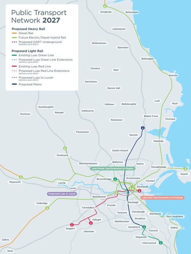
1.       INTRODUCTION
On behalf of the applicant, 1 Wyckham Land Limited, this Statement of Consistency accompanies a
planning application to An Bord Pleanála for a proposed Strategic Housing Development on lands
located at Marmalade Lane, Gort Muire, Dundrum, Dublin 16, in accordance with Section 5 of the
Planning and Development (Housing) and Residential Tenancies Act 2016.

The site is located to the east of Gort Muire, Carmelite Centre, and is accessed from Wyckham Avenue,
off Wyckham Way. The application site includes lands formerly part of/owned by the Gort Muire
Carmelite Centre and is located adjacent to Protected Structures (RPS No. 1453). It comprises an open
field having formerly been used as agricultural lands. The boundaries are delineated by modern post
and rail fencing with some mature trees along the boundaries. There are no built structures on the
site.

The development will comprise a ‘Build to Rent’ (BTR) apartment development consisting of 7 no.
blocks ranging in height up to 9 storeys (and including two levels of basement/undercroft located in
the northern portion of the site). 628 no. apartments are proposed comprising 279 no. 1 -beds 318
no. 2-beds & 31 no. 3-beds.

All residential units provided with associated private balconies/terraces to the north/south/east/west
elevations. The BTR development will also include Resident Support Facilities & Resident Services &
Amenities (total floor area c.3897 sq.m) including reception, parcels/delivery area, store areas, co-
working spaces, residents lounge, games room, cinema/function room, music room, dining area,
meeting room, gym, dog grooming, breakout areas, management offices and showroom. The
development also includes a creche (c.620 sq.m), ‘Grab ‘n go’ retail unit (c.18 sq.m) and café (c.143
sq.m). Provision of 278 no. car parking spaces, 1,354 no. cycle parking spaces and 21 no. motorcycle
spaces.

Vehicular/pedestrian/cyclist accesses including from Wyckham Avenue and including improvement
works to the existing Carmelite Centre access road and entrance.

All associated site development works, open spaces, roof gardens, landscaping, boundary treatments,
plant areas, waste management areas, cycle parking areas, and services provision (including ESB
substations).

The main development statistics relating to the development are summaries below:

 Development Proposal                               Statistics
 No. of apartments                                  628 no. as follows:
                                                    - 279 no. 1 bed (44%)
                                                    - 318 no. 2 bed (51%)
                                                    - 31 no. 3-bed (5%)
 Residential facilities / Mixed Uses                Creche (620 sq.m)
                                                    Grab n go retail (18 sq.m)
                                                    Café (143 sq.m)

                                                    Co-working spaces (877sq.m)
                                                    Reception (105 sq.m)
Games room (243 sqm)
                  Music room (23sq.m)
                  Cinema/ function room (132 sq.m)
                  Meeting room (83 sq.m)
                  Parcel room (68 sq.m)
                  Dog grooming (46 sq.m)
                  Private Dining (135 sq.m)
                  Gym (478 sq.m)
                  Residents lounge (52 sq.m)
                  Shared stores (318 sq.m)
                  Breakout spaces (1104 sq.m)
                  Management offices (154 sq.m)
                  Showroom (79 sq.m)
Site Area         Gross Site Area: 4.0305 ha
                  Net site area: 3.4918 ha

                  Net site area is Gross site area minus the
                  following:
                   - Wyckham Avenue,
                   - Existing Carmelite Centre access road
                       and adjoining areas (within application
                       site)

                  Gross Residential Density: 156 per hectare

                  Net Residential Density: 180 units per
                  hectare
Plot Ratio        1: 1.41 based on the gross area
Site Coverage     26.19 % based on the gross area
Building Height   Up to 9 storeys
Aspect            41% single aspect
                  59% dual aspect
Open Space        Gross open space provision (comprising the
                  public open spaces, communal open spaces
                  (at grade), and pedestrian parades) totals
                  c.24,185 sq.m or 2.42ha (c.19,606.5 sq.m +
                  4,578.58 sq.m). This represents c.69% of the
                  net site area.

                  The net open space provision (i.e. the public
                  and communal open spaces (at grade) minus
                  the pedestrian parades) is c.13,137 sq.m
                  (c.1.3ha) (4,578.58 sq.m + 8,559 sq.m) which
                  represents 37% of the net application site
                  area.
Carparking        278 no. car spaces

                                                                  4
• 26 of these are for GoCar
 Cycle parking                                   1354 no. bicycle spaces
 Motorcycle                                      21 no. motorcycle spaces
 Vehicular Access                                From Wyckham Avenue

This Statement of Consistency demonstrates that the proposal is in accordance with the relevant
national planning policy, guidelines issued under Section 28 of the Planning and Development Act
2000 (as amended), and with local planning policy. It should be read in conjunction with the
accompanying detailed documentation prepared McGill Planning, Scott Tallon Walker Architects,
NMP Landscape Architects, Punch Consulting Engineers, Digital Dimensions, Altemar Ecology, Axis
Consulting Engineers, CMK Horticulture and Arboriculture Ltd, IES Consulting Engineers, Global
Apartment Advisors, Molloy Associate Conservation Architects, Moore Group Archaeological and
Environmental Services.

                                                                                               5
2. NATIONAL & REGIONAL PLANNING POLICY
The key national and regional policies and guidelines (including Section 28 Guidelines) relevant to the
proposed development are as follows:

    •   Ireland 2040 Our Plan - National Planning Framework (2018);
    •   Regional Spatial and Economic Strategy 2019- 2031;
    •   Guidelines for Planning Authorities on Urban Development and Building Heights (2018);
    •   Guidelines for Planning Authorities on Sustainable Urban Housing: Design Standards for New
        Apartments (2018);
    •   Guidelines for Planning Authorities on Sustainable Residential Development in Urban Areas
        (2009), and the accompanying Urban Design Manual;
    •   Delivering Homes, Sustaining Communities (2008) and the accompanying Best Practice
        Guidelines- Quality Housing for Sustainable Communities;
    •   Quality Housing for Sustainable Communities (2007);
    •   Design Manual for Urban Roads and Streets (2019);
    •   Guidelines for Planning Authorities on Childcare Facilities (2001);
    •   Smarter Travel – A New Transport Policy for Ireland (2009-2020);
    •   The Planning System and Flood Risk Management (2009).
    •   Climate Action Plan 2019

PROJECT IRELAND 2040 OUR PLAN - NATIONAL PLANNING FRAMEWORK (2018)
The National Planning Framework (NPF) is the Government’s plan to cater for the extra one million
people that is anticipated to be living in Ireland. The Eastern and Midland Region (including Dublin)
will, by 2040, be a Region of around 2.85 million people, at least half a million more than today.

The NPF Strategy includes the following aims:

    •   Supporting the future growth and success of Dublin as Ireland’s leading global city of scale, by
        better managing Dublin’s growth to ensure that more of it can be accommodated within and
        close to the city.
    •   Enabling significant population and jobs growth in the Dublin metropolitan area, together with
        better management of the trend towards overspill into surrounding counties.
    •   Targeting a greater proportion (40%) of future housing development to be within and close to
        the existing ‘footprint’ of built-up areas.
    •   Making better use of under-utilised land and buildings, including ‘infill’, ‘brownfield’ and
        publicly owned sites and vacant and under-occupied buildings, with higher housing and jobs
        densities, better serviced by existing facilities and public transport.

This major new policy emphasis on renewing and developing existing settlements aims to prevent the
continual expansion and sprawl of our cities. This aim for Compact Growth promotes “Making better
use of under-utilised land and buildings, … with higher housing and jobs densities, better serviced by
existing facilities and public transport.” This approach not only makes better use of land but it can also
have a “transformational difference” to towns and villages bringing new life and footfall to an area
and contributing to the viability of services, shops and public transport, and by increasing the housing
supply, enables more people “to be closer to employment and recreational opportunities, as well as to
walk or cycle more and use the car less” (section 2.6).

                                                                                                         6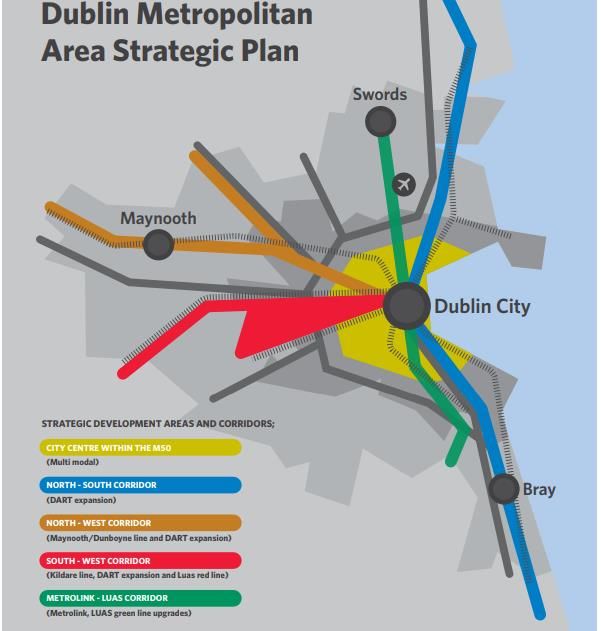
As a result of this new policy approach, and as set out in section 4.5, there is a recognition that infill,
and brownfield development is more challenging to deliver across multiple streams including land
management and integration within existing communities who prefer the status quo to be
maintained. As a result, to enable development a flexible approach to planning policies and standards
needs to be “focusing on design led and performance-based outcomes, rather than specifying
absolute requirements in all cases… planning standards should be flexibly applied in response to well-
designed development proposals that can achieve urban infill and brownfield development objectives
in settlements of all sizes.” In particular Section 4.5 highlights that “general restrictions on building
height or universal standards for car parking or garden size may not be applicable in all
circumstances in urban areas and should be replaced by performance-based criteria appropriate to
general location, e.g. city/town centre, public transport hub, inner suburban, public transport corridor,
outer suburban, town, village etc.” It highlights that there “should also generally be no car parking
requirement for new development in or near the centres of the five cities, and a significantly reduced
requirement in the inner suburbs of all five.”

The NPF projects that 550,000 additional homes will be required by 2040 to meet future demand.
These new homes should be located in places that can support sustainable development and in cities
and larger towns where large scale housing exists. To achieve this housing target, we will need to build
inwards and upwards and apartments will need to become a more prevalent form of housing. The NPF
also states that that “to avoid urban sprawl and the pressure that it puts on both the environment and
infrastructure demands, increased residential densities are required in our urban areas”. Key National
Policy Objectives which relate to this site are set out below:

 National Policy Objective                       Evaluation of Consistency
 National Policy Objective 4                   The proposed development will create a high-
 Ensure the creation of attractive, liveable, quality, attractive and liveable place for residents.
 well designed, high quality urban places
 that are home to diverse and integrated
 communities that enjoy a high quality of life
 and well-being.

 National Policy Objective 11                    The proposal is located within the existing area of
 In     meeting      urban       development     Dundrum, within the metropolitan area of Dublin
 requirements, there will be a presumption in    City.
 favour of development that can encourage
 more people and generate more jobs and          The site is c. 600m from the Ballinteer stores with its
 activity within existing cities, towns and      range of local shops and chemists. In addition to this
 villages, subject to development meeting        neighbourhood centre, the site is c.750m (10
 appropriate planning standards and              minutes’ walk) from the Dundrum Town Centre and
 achieving targeted growth                       1.5km (15 minutes’ walk) from SuperValu shopping
                                                 centre.

                                                 Dundrum village centre has a library, banks, and
                                                 other services, which combined with the Dundrum
                                                 town centre, results in a vibrant area which hosts
                                                 many desirable residential and commercial
                                                 amenities with multiple cafes, bars, restaurants, food
                                                 retailed and leisure facilities such as gyms.

                                                                                                           7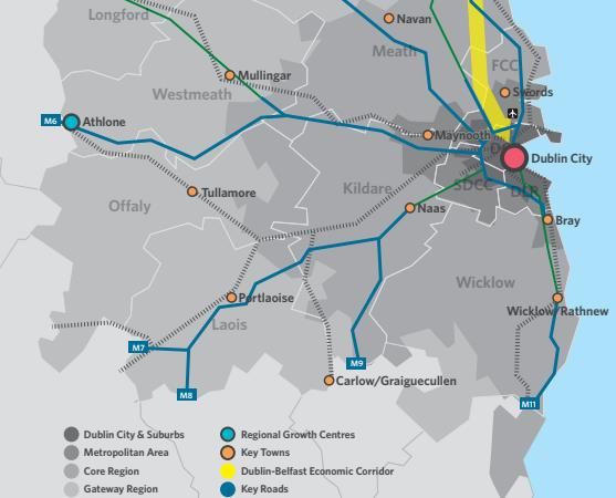
Beacon Hospital and the employment hub of
                                                   Sandyford are just over 1km to the east.

                                                   The site is well connected with public transport
                                                   services. Dublin bus routes 44, 44B and 116 serves
                                                   the site along Sandyford road and routes 14, 14C, 75
                                                   and 175 serving the site along Wyckham Way. The
                                                   site is 750m-950m from Balally Luas station and
                                                   1.4km from Kilmacud station on the Green Luas line.

National Policy Objective 13                       It is clear that there is a strong emphasis towards
In urban areas, planning and related               increased building heights in appropriate locations
standards, including in particular building        within existing urban centres and along public
height and car parking will be based on            transport corridors. As such it is respectfully
performance criteria that seek to achieve          submitted that the proposed building height is in line
well-designed high quality outcomes in             with government guidance and emerging trends for
order to achieve targeted growth. These            sustainable residential developments.
standards will be subject to a range of
tolerance that enables alternative solutions
to be proposed to achieve stated outcomes,
provided public safety is not compromised
and the environment is suitably protected.

National Policy Objective 27                       Walking and cycling are prioritised throughout the
Ensure the integration of safe and                 scheme with minimal vehicular access into the
convenient alternatives to the car into the        scheme and a high quality public realm.
design of our communities, by prioritising
walking and cycling accessibility to both  This design has helped to create a safe pedestrian
existing and proposed developments and     friendly environment with numerous pedestrian and
integrating physical activity facilities for all
                                           cycle routes through the scheme. This will make
ages.                                      walking and cycling attractive with good links into the
                                           wider area with its range of existing facilities and very
                                           good public transport.
National Policy Objective 33               The proposed density is considered appropriate for
Prioritise the provision of new homes at this site which is located within the established
locations that can support sustainable residential area of Dundrum, in close proximity to the
development and at an appropriate scale of Dundrum town centre and Ballinteer Stores.
provision relative to location.

National Policy Objective 35                       The proposed development will provide a high
Increase residential density in settlements,       density residential scheme on former institutional
through a range of measures including              lands within the existing built up area of Dundrum.
reductions in vacancy, reuse of existing
buildings, infill development schemes, area        The proposal will bring this under-utilised site back
or site-based regeneration and increased           into use and will increase the residential density of
building heights.                                  the area.

                                                                                                            8
EVALUATION OF CONSISTENCY
 The subject site is located within the metropolitan area of Dublin City which is identified for
 significant residential growth over the next two decades.

 The proposed development seeks to deliver a significant quantum of residential development at a
 site that is located within a well-established suburban location within walking distance of a
 multitude of services, public transport options and amenities.

 In addition to retail and employment locations, the site is well located with respect to primary and
 secondary schools. Secondary education centres St. Tiernan’s community school and Wesley college
 will have direct pedestrian connection to the site. Ballinteer Secondary school, and St. Benildus
 college are also present at an accessible distance of the site. 8 Primary schools fall within the 5-
 minute drive time catchment of the site.

 Subject to formal agreement with DLRCC Ballawley Park and Playground will be accessible from the
 proposed development providing its residents access to multiple playgrounds and recreational area.
 Marley Park is within 2.4km of the site providing an additional wide range of outdoor recreation
 facilities. In addition, the site is 1.4km from dlr Meadowbrook Leisure (14 minutes’ walk) which has
 a gym, swimming pool, astro pitches.

 The proposed development will provide for a high quality residential scheme through the design
 and the materials and finishes proposed. In addition, the proposed units are in meet the apartment
 size requirement as stated in the Apartment Guidelines.

 Development of these lands is considered to be fully in accordance with the recommendations of
 the NPF.

REBUILDING IRELAND – ACTION PLAN FOR HOUSING AND HOMELESSNESS 2016
Rebuilding Ireland was launched in 2016 with the objective to double the annual level of residential
construction to 25,000 homes and deliver 47,000 units of social housing in the period to 2021. It was
based on 5 no pillars. Pillar 3 – Build More Homes aims to increase the output of private housing to
meet demand at affordable prices.

 EVALUATION OF CONSISTENCY
 The proposed development is consistent with Pillar 3 to build more homes. The proposed
 development provides for 628 no. new build to rent apartment units. The provision of the 628 no.
 residential unit will add to a housing stock of the area and cater to the increasing demand for this
 existing urban area.

REGIONAL SPATIAL AND ECONOMIC STRATEGY 2019-2031
Under the Local Government Reform Act 2014 the Regional Planning Framework has been revised
with the previous Regional Authorities/Assemblies (ten in total) now replaced with three Regional
Assemblies. The Regional Authorities for the Greater Dublin Area – The Dublin Region and the Mid-
East Region - have been replaced by the Eastern and Midland Regional Assembly.

The Regional Spatial and Economic Strategy was adopted on the 28th June 2019 and is a strategic plan
and investment framework to shape the future development of the eastern regional to 2031 and

                                                                                                    9
beyond which is a new concept in Irish Planning tying spatial planning to economic factors. The region
covers nine counties, Longford, Westmeath, Offaly, Laois, Louth, Meath, Kildare, Wicklow, and Dublin.
The vision for the region is to “create a sustainable and competitive Region that supports the health
and wellbeing of our people and places, from urban to rural, with access to quality housing, travel and
employment opportunities for all.”
The RSES will support the implementation of Project Ireland 2040 – the National Planning Framework
(NPF) and National Development Plan (NDP). It addresses employment, retail, housing, transport,
water services, energy and communications, waste management, education, health, sports and
community facilities, environment and heritage, landscape, sustainable development and climate
change. The vision for the RSES is to create a sustainable and competitive region that supports the
health and wellbeing of our people and places, from urban to rural, with access to quality housing,
travel and employment opportunities for all. The RSES identifies that the Dublin Metropolitan Area is
“to realise ambitious compact development targets at least 50% of all new homes within or contiguous
to the existing built up area in Dublin and at least 30% in other metropolitan settlements.”
The RSES also sets out 16 Regional Spatial Objectives which align with the 3 key principles of the RSES
and have been development to ensure that positive strategic environmental outcomes occur. Ten of
which, the most relevant to this site, are set out below.
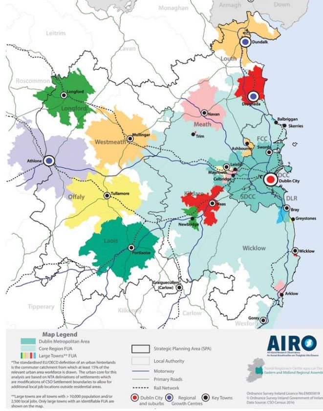
10This document also identifies the public transport network ambitions for 2027 and the settlement
strategy for the region. Dublin city and its suburbs are at the top of this hierarchy in terms of the need
to ensure highly concentrated development in this highly accessible area.
Figure 1 Dublin Metropolitan Area
11Figure 2 Public Transport Network for 2027
In section 4.4 of the RSES identifies that in order to achieve compact growth 50% of housing needs to
be provided within or contiguous to the build-up area of Dublin City and suburbs. To achieve this the
Metropolitan Area Strategic Plan identifies strategic residential and employment corridors along key
public transport corridors, both existing and proposed. It also includes, in RPO 4.3 “support the
consolidation and re-intensification of infill/ brownfield sites to provide high density and people
intensive uses within the existing built up area of Dublin City and suburbs and ensure that the
development of future development areas is co-ordinated with the delivery of key water infrastructure
and public transport projects.”
12Figure 3 Settlement Strategy
13The guiding principles for growth in the Dublin Metropolitan area are set out in section 5.3 and include
• Compact sustainable growth and accelerated housing delivery – To promote sustainable
consolidated growth of the Metropolitan Area, including brownfield and infill development, to
achieve a target to 50% of all new homes within or contiguous to the built-up area of Dublin
City and suburbs, and at least 30% in other settlements. To support a steady supply of sites
and to accelerate housing supply, in order to achieve higher densities in urban built up areas,
supported by improved services and public transport.
• Integrated Transport and Land use – To focus growth along existing and proposed high quality
public transport corridors and nodes on the expanding public transport network and to support
the delivery and integration of ‘BusConnects’, DART expansion and LUAS extension
programmes, and Metro Link, while maintaining the capacity and safety of strategic transport
networks.
• Metropolitan Scale Amenities – To enhance provision of regional parks and strategic Green
Infrastructure, to develop an integrated network of metropolitan scale amenities, and to
develop greenways/blueways along the canals, rivers and coast, as part of the implementation
of the National Transport Authorities’ Cycle Network Plan for the Greater Dublin Area.
14It also identified at RPO 5.3 that “Future development in the Dublin Metropolitan Area shall be planned
and designed in a manner that facilitates sustainable travel patterns, with a particular focus on
increasing the share of active modes (walking and cycling) and public transport use and creating a safe
attractive street environment for pedestrians and cyclists.”
MASP Housing and Regeneration policy objective RPO 5.4 states that “Future development of strategic
residential development areas within the Dublin Metropolitan area shall provide for higher densities
and qualitative standards as set out in the ‘Sustainable Residential Development in Urban Areas’,
‘Sustainable Urban Housing; Design Standards for New Apartments’ Guidelines, and ‘Urban
Development and Building Heights Guidelines for Planning Authorities’”
EVALUATION OF CONSISTENCY
The subject development seeks to provide for residential development on a key urban infill site and
to increase densities, heights and urban consolidation in this inner suburban location. The proposed
development therefore is compliant with the overall policies and objectives of the RSES in this
regard.
Dundrum has access to high quality public transport including excellent high frequency bus services
and the green line Luas. It has excellent potential to promote sustainable mobility and achieve the
vision of ‘walkable’ communities.
This proposed development will open up new links for the community through the Gort Muire lands
creating new public open spaces and pedestrian and cycle connectivity that does not currently exist.
The proposal is for a Build to Rent development which will enhance the tenure mix in this area in
line with the requirements of the RSES.
URBAN DEVELOPMENT & BUILDING HEIGHTS: GUIDELINES FOR PLANNING AUTHORITIES, 2018
The Guidelines set out national planning policy guidelines on building heights in urban areas in
response to specific policy objectives set out in the National Planning Framework and Project Ireland
2040. There is a presumption in favour of high buildings at public transport nodes and state that it is
Government policy to promote increased building height in locations with good public transport
services.
15Under Section 28 (1C) of the Planning and Development Act 2000 (as amended), Planning Authorities
and An Bord Pleanála are required to have regard to the guidelines and apply any specific planning
policy requirements (SPPR’s) of the guidelines in carrying out their function. SPPRs as stated in the
Guidelines, take precedence over any conflicting, policies and objectives of development plans, local
areas plan and strategic development zone planning schemes.
The Guidelines emphasise the policies of the NPF to increase levels of residential development in
urban centres and increase building heights and overall density by both facilitating and encouraging
the development of increased heights and densities by Local Authorities and An Bord Pleanála. It
identifies the need to focus planning policy on “reusing previously developed “brownfield” land,
building up urban infill sites”.
They place significant emphasis on promoting development within the existing urban footprint
utilising the existing sustainable mobility corridors and networks. “In order to optimise the
effectiveness of this investment in terms of improved and more sustainable mobility choices and
enhanced opportunities and choices in access to housing, jobs, community and social infrastructure,
development plans must actively plan for and bring about increased density and height of
development within the footprint of our developing sustainable mobility corridors”. It goes on to
highlight that “the preparation of development plans, local areas plans, and Strategic Development
Zone Planning Schemes and their implementation in the city, metropolitan and wider urban areas must
therefore become more proactive and more flexible in securing compact urban growth through a
combination of both facilitating increased densities and building heights”.
Policy Evaluation of consistency
Section 3.1 Development Management
Principles The proposed development seeks to deliver a significant
residential development at a site that is highly accessible in
In relation to the assessment of individual terms of public transport with the Luas stop at Balally less
planning applications and appeals, it is than 1km walk from the site and the area also served by high
Government policy that building heights frequency bus services.
must be generally increased in appropriate
urban locations. There is therefore a The proposed development is also less than 1km from
presumption in favour of buildings of Dundrum Town Centre the main retail and employment hub
increased height in our town/city cores and in the area. The site also benefits from close proximity to 2
in other urban locations with good public large schools and a variety of other social infrastructure.
transport accessibility. Planning authorities
must apply the following broad principles in Furthermore, we note the following:
considering development proposals for
buildings taller than prevailing building • The proposed development secures the NPF
heights in urban areas in pursuit of these objective of compact urban growth around high
guidelines: quality public transport,
• The development accords with National Policy
• Does the proposal positively assist
Objective (NPO) 33 in delivering an appropriate scale
in securing National Planning
of sustainable residential development at a highly
Framework objectives of focusing
accessible location and that is provided with
development in key urban centres
significant social infrastructure and amenities.
and in particular, fulfilling targets
• The development accords with NPO 35 in achieving
related to brownfield, infill
higher density through increased building height of
development and in particular,
generally 3-9 storeys.
effectively supporting the National
Strategic Objective to deliver
16compact growth in our urban • The development accords with NPO 13 in terms of
centres? increasing building height and reducing car parking
• Is the proposal in line with the to provide a high quality and high amenity residential
requirements of the development development that at the same time achieves
plan in force and which plan has compact urban growth at an accessible location.
taken clear account of the • The development accords with NPO 27 in providing
requirements set out in Chapter 2 of a development that is well served in terms of social
these guidelines? infrastructure and convenience all within walking
• Where the relevant development distance of the new homes, which reduces the need
plan or local area plan pre-dates for the car and which also facilitates alternative
these guidelines, can it be modes of transport (Luas, bus and cycle) to get to the
demonstrated that implementation city centre and local district centres (Dundrum Town
of the pre-existing policies and Centre, Sandyford and Carrickmines) for wider
objectives of the relevant plan or services and employment.
planning scheme does not align
with and support the objectives and The policies and objectives of the DLRCC Development Plan
(2016) as they relate to the subject lands are not considered
policies of the National Planning
to align or efficiently support the objectives and policies of the
Framework? 2018 NPF and related Section 28 Guidelines.
The building height limits set down in the Building Heights
Strategy and density range of 35-50 units per ha under Policy
Section 3.2 Development Management RES5 are considered unduly restrictive and limit the potential
Criteria for increased residential development at this highly accessible
location, which is contrary to the principles of the NPF.
In the event of making a planning
application, the applicant shall demonstrate These policies also conflict with SPPR 1 of the Building Heights
to the satisfaction of the Planning Authority/ Guidelines which states that plans should “not provide for
An Bord Pleanála, that the proposed blanket numerical limitations on building height. “
development satisfies the following criteria:
The site is well connected with public transport services.
At the scale of relevant city/town: Dublin bus routes 44, 44B and 116 serves the site along
-The site is well served by public transport Sandyford road and routes 14, 14C 75 and 175 serving the site
with high capacity, frequent service, and along Wyckham Way. The site is c.900m from Balally Luas
good links to other modes of public station.
transport.
Furthermore, the application site is located within “Corridor-
F (Arklow – Wicklow – Greystones – Bray – Cherrywood –
Dundrum – Dun Laoghaire – Dublin City Centre)”, in the inner
metropolitan area. There are multiple upgrades in this area to
both the DART and through bus connects all of which aim to
create a modal shift to other modes of transport other than
reliance on cars.
It is c. 600m from the Ballinteer stores with its range of local
shops and chemists. In addition to this neighbourhood centre
it is c.750m (10 minutes’ walk) from the Dundrum Town
Centre, with its wide range of shopping facilities, restaurants
and services, 1.5km (15 minutes’ walk) from SuperValu
shopping centre, 1.4km from dlr Meadowbrook Leisure (14
minutes’ walk) which has a gym, swimming pool, astro
pitches.
The site is also within a 15 minute walk of Dundrum village
centre which has a library, banks, and other services, which
17combined with the Dundrum town centre, results in a vibrant
area which hosts many desirable residential and commercial
amenities with multiple cafes, bars, restaurants, food retailed
and leisure facilities such as gyms. Beacon Hospital and the
employment hub of Sandyford is just over 1km to the east.
The site is also well located with respect to primary and
secondary schools. Secondary education centres St. Tiernan’s
community school and Wesley college will have direct
pedestrian connection to the site. Ballinteer Secondary
school, and St. Benildus college are also present at an
accessible distance of the site. 8 Primary schools fall within
the 5-minute drive time catchment of the site.
Ballawley Park and Playground will, subject to DLRCC
agreement, be accessible from the proposed development
providing its residents access to multiple playgrounds and
recreational area. Finally, Marlay Park is within 2.4km of the
site providing an additional wide range of outdoor recreation
facilities.
The proposed development will provide for a high quality
residential scheme through the design and the materials and
finishes proposed. In addition, the proposed units meet the
apartment size requirement as stated in the Apartment
Guidelines.
• It is clear that there is a strong emphasis towards
increased building heights in appropriate locations within
existing urban centres and along public transport
corridors. As such it is respectfully submitted that the
proposed building height is in line with government
guidance and emerging trends for sustainable residential
developments.
At the scale of district/ neighbourhood/ The proposed development responds very positively to its
street; context by fully incorporating the natural elements of the site
- The proposal responds to its overall natural particularly the mature trees and hedgerows into a
and built environment and makes a positive comprehensive landscape and open space design. This
contribution. ensures that future residents will have direct access to a wide
- The proposal is not monolithic and avoids variety of large open spaces for various recreational uses.
long, uninterrupted walls of building.
- The proposal enhances the urban design The development respects the built environment giving the
context for public spaces and key historic buildings within the Carmelite Centre a new context
thoroughfares. and opening them up to the public. In turn this helps create a
- The proposal positively contributes to the unique sense of place and identity for the new development
mix of uses and/ or building/ dwelling that is grounded in the history of the area.
typologies.
At the same time the development reflects the highly
accessible and strategic location of the site. The site has the
opportunity to create an appropriate scale of development
that properly defines this location.
The architectural design is modern and visually interesting
with a variety of designs and varying heights and finishes
proposed. It is an innovative, attractive design appropriate
for this location.
18It is considered that the breaking up of the proposal into 7
blocks, along with the variation in heights from 3 rising at the
southern edge rising up to 9 storeys in the centre of the site
will ensure that this proposed development is not monolithic.
The proposal is largely a car free development which provides
significant communal and public open space. A key design
feature of this proposal is the future potential (subject to
DLRCC agreement) to opening up of Ballawley Park to the
wider community of Dundrum and Ballinteer by providing
new pedestrian links through the development.
The development will significantly increase and improve the
overall mix of residential types within the Dundrum/Ballinteer
area as a whole and will establish a self-contained and self-
sufficient, sustainable new urban community.
At the scale of the site/building: The submitted Sunlight/Daylight Report demonstrates that on
- Maximise access to natural daylight, the 21st of March for the Proposed Scheme, all amenity areas
ventilation and views and minimise receive more than 2 hours of sunlight on over 50% of their
overshadowing and loss of light. area, thus exceeding the BER recommendations.
A Shadow, Daylight & Sunlight Impact Report has been
prepared by Axiseng Consulting Engineers which confirms the
following:
• There is no reduction in the garden spaces of
adjoining residential properties at Parkvale & Wesley
receiving sunlight as a result of the proposed
development, and they will continue to receive 2
hours of sunlight on 21 March, and therefore are
compliant with BRE guidance.
• More than half of all proposed and existing amenities
area situated between development buildings
continue to receive 2 hours of sunlight on 21st March
and therefore is comply with BRE’s 2011 guidance.
• Garden and Open spaces situated outside the
Carmelite Order Building Site continue to receive 2
hours of sunlight on 21 March and therefore the
development is in compliance with the BRE’s 2011
guidance document Site Layout Planning for Daylight
and Sunlight recommendation.
• In relation to daylighting the vast majority of habitable
rooms analysed are in line with guidance for living spaces
having a minimum daylight factor of 1.5%. Less than
2.45% of living rooms do not achieve the minimum ADF
target, with these rooms falling just slightly below the
recommended levels. Furthermore, these rooms are
mainly at lower levels or with balcony overhangs and yet
still receive a good level of daylight.
Specific Assessments: A wind study has been prepared and the general layout and
-Specific impact assessment of the micro- height range is considered not to create any adverse
climatic effects such measures to avoid/ conditions at ground level or within balconies, subject to
mitigate such micro-climatic effects and, standard mitigation at certain locations such as the provision
where appropriate, shall include an
19assessment of the cumulative micro-climatic of canopies near main entrances, and specific landscape
effects where taller buildings are clustered. measures.
-Development locations in proximity to
sensitive bird/bat areas need to consider the An EIAR and AA Screening Report (with all associated surveys)
potential interaction of the building location, has been completed and submitted with the application.
materials, and artificial lighting.
-Relevant environmental assessment The EIAR concludes that the development will not result in
requirements. any significant negative impact on the environment subject to
mitigation measures.
The AA Screening Report concludes that there is no potential
for meaningful connectivity to any other European Sites.
Significant effects on any European sites as a result of the
proposed Project can be ruled out and potential significant
effects on European sites have been excluded at a preliminary
screening stage.
SPPR 3 This proposal is in accordance with the NPF and associated
It is a specific planning policy requirement Section 28 Guidelines, in terms of make the optimal
that where; 1. an applicant for planning residential return of zoned, serviced and highly accessible
permission sets out how a development land which is appropriately located in close proximity to public
proposal complies with the criteria above; transport employment and social infrastructure.
and 2. the assessment of the planning
authority concurs, taking account of the
wider strategic and national policy
parameters set out in the National Planning
Framework and these guidelines; then the
planning authority may approve such
development, even where specific objectives
of the relevant development plan, local area
plan or planning scheme may indicate
otherwise.
EVALUATION OF CONSISTENCY
It is considered that the subject site is an appropriate site for a development with heights up to 9
storeys. The proposal responds to its overall natural and built environment and it makes a positive
contribution to the urban context, creating a new urban signpost within the Dundrum area.
The proposed development is set out in seven residential blocks located along two primary axis
within the site. The materials and finishes of the proposed blocks will be designed to a high
architectural standard. The materials and finishes have also been considered with regard to the
surrounding existing pattern of development and material pallet in the locality. It is considered that
the proposed development is in keeping with the character and building fabric of the area and will
respect the adjoining protected structures.
The proposed development provides for significant new public open spaces within a scheme which
is predominantly car free. It is respectfully submitted that the proposed development has had regard
to the planning policy framework as set out in the building height guidelines and National Planning
Framework. The provision of residential development at this location in blocks up to 9 storeys in
height is supported by the height guidelines which encourages increased density and building
heights. The proposed development complies with such objectives therefore is considered to be in
accordance with the provisions of national policy guidelines.
20GUIDELINES FOR PLANNING AUTHORITIES ON SUSTAINABLE RESIDENTIAL DEVELOPMENT IN URBAN
AREAS, 2009
The guidelines set out the key planning principles to be reflected in development plans and local area
plans, to guide the preparation and assessment of planning applications for residential development
in urban areas.
The Guidelines elaborate a range of high-level aims for successful and sustainable residential
development in urban areas. These are assessed against the proposed scheme as follows:
GUIDANCE EVALUATION OF CONSISTENCY
Prioritise walking, cycling and public The application site will be served by high quality walking
transport, and minimise the need to and cycling links connecting the site to the surrounding
use cars; environs including Dundrum Town Centre and the nearby
bus and Balally Luas stop.
The development can provide (subject to DLRCC approval)
a previously unavailable new connection between
Dundrum/Ballinteer and Ballawley Park and Sandyford
village. This will be in the form of a car-free public street
where pedestrians and cyclists can travel safely through
the heart of the scheme.
There are only 278 no. car parking spaces allocated as part
of this scheme spaces and 21 no. Motorcycle spaces. While
a total of 1,354 no. bicycle parking spaces are provided.
Deliver a quality of life which residents The scheme has been designed to the highest residential
and visitors are entitled to expect, in standard. All units accord with the quantitative and
terms of amenity, safety and qualitative standards sets down in the national apartment
convenience; guidelines and the DLRCC County Development Plan.
Future residents will live in a uniquely safe residential
environment with streets free of cars and a multitude of
access options to social infrastructure, open spaces and
public transport in the area.
Provide a good range of community The development will consist of apartments with the
and support facilities, where and when following residential facilities: gym, creche, café,
they are needed and that are easily residential amenities area, games room, music room,
accessible; cinema/function room, and co-working space .
The development is well located in relation to
existing/planned social infrastructure in the area in
particular Dundrum Town Centre and Ballawley Park, it is a
central location to Dublin, Wicklow/Dublin Mountains to
the south and Dublin Bay to the north east.
Present an attractive, well-maintained The layout of development has been designed to enhance
appearance, with a distinct sense of the accessibility of the site and through the site. All of the
place and a quality public realm that is routes through the development will provide increased
easily maintained; connectivity to the area which is well overlooked. The
21public realm proposed is high quality with a range of
different spaces meeting varying needs throughout the
development.
Are easy to access for all and to find There is one vehicle access into the site off Wyckham
one’s way around; Avenue which leads into the heart of the development.
There are additional pedestrian/ cycle access routes
potentials into and through the site with a central
landscaped area along with other landscaped character
areas ensuring that the layout is logical, direct, interesting
and wayfinding uncomplicated. A pedestrian link
surrounds the development providing an open space
network.
Promote the efficient use of land and The proposal seeks to import best practice
of energy, and minimise greenhouse construction/engineering techniques and use of energy
gas emissions; efficient materials to maximise energy capacity and
minimise impacts of climate change in accordance with
current buildings regulations.
Provide a mix of land uses to minimise The site is zoned for residential development which is
transport demand; proposed. Support services in terms of the gym, creche,
co-working space, cinema/function room, meeting room,
and private dining with high quality outdoor spaces are
also provided. The scheme is within 10 minute walk of
Dundrum Town Centre and has ease of access to a variety
of existing facilities in the Dundrum/ Ballinteer and
Sandyford area.
Promote social integration and provide A range of unit sizes is proposed for the scheme including
accommodation for a diverse range of 1, 2 and 3 bedroom apartments. This mix of residential
household types and age groups; unit types results in the mix in the general area being
significantly improved.
Enhance and protect the green The site comprises of an underutilised greenfield site. The
infrastructure and biodiversity; and proposal will result in a significant improvement in the
green landscaping and biodiversity of the area as the level
of green infrastructure will be increased significantly. It will
provide further connection to Ballawley Park (subject to
DLRCC approval).
Enhance and protect the built and The proposed development does not have any protected
natural heritage. structures on the site, but it is located in close proximity to
a range of protected structures. The proposal has been
designed to ensure a sympathetic composition in relation
to these buildings as well as the more modern surrounding
buildings. An Architectural Heritage Assessment and an
Archaeological Assessment are included within the EIAR.
The layout of the site enhances the visibility of the
neighbouring structures.
The Guidelines support a plan-led approach to the location, scale and nature of major residential
development, as per the Planning and Development Act.
22A sequential approach to the development of land is recommended with zoning to extend outwards
from the centre of an urban area, and undeveloped and infill lands closest to the core and public
transport routes being given preference.
The Guidelines promote urban design to create places of high quality and distinct identity, to provide
connectivity, permeability, safety, legibility and sense of place.
In this regard, the Guidelines are accompanied by a Design Manual (discussed below) which
demonstrates how design principles can be applied in the design and layout of new residential
developments, at a variety of scales of development and in various settings.
To ensure sustainable communities the Guidelines stress that community facilities are also to be
provided for.
EVALUATION OF CONSISTENCY
In relation to schools we note the following located in the immediate area, with even greater
choice in a slightly wider district (not listed below):
1. St Tiernan’s Community School
2. St Attractas Junior National School
3. St Olafs National School
4. Queen of Angels Primary School
5. Taney National School
6. Holy Cross National School
7. Wesley College
8. Gaelscoil Na Fuinseoige
9. Ballinteer Educate Together National School
10. Ballinteer Community School
11. Scoil Naithi
12. Our Lady’s Girls’ National School
13. Na Maighdine Muire Girl
In relation to childcare facilities there are also many crèches and playschools within the area
including:
1. Dundrum Montessori School and Afterschool
2. Handprints Montessori Preschool
3. Rathdown Community Playgroup
4. Clever Clogs Creche and Montessori
5. Care-Well Day Nursey and Montessori School
6. Once Upon a Time-Dundrum
7. Cool Kids Crèche Limited
8. Ballinteer Playschool
9. Absorbent Minds
10. Broadford Montessori Pre School
11. Naionra Dhun Droma
12. Naionra Naithi
13. Hillview Community Resource Centre
2314. Little Willow Academy
15. Little Minnows Creche – Ballinteer
16. Narnia Nursery School
In relation to community centres, healthcare facilities and neighbourhood centre uses we note the
site is within c. 500m of Dundrum Town Centre, which is a retail area, has a variety of community
facilities including gyms, restaurants, shops and other leisure facilities. It is also worth noting the
high quality facilities provided as part of this development such as the gym concierge and media
rooms, games room and hot desk spaces.
In relation to density the subject lands are considered ‘adjacent to Public Transport Corridors’
under the Guidelines given the lands are located within c. 750-950 m of Balally Luas stop and within
300m of bus stops on Wyckham Way and the R826.
The Guidelines recommend minimum net densities of 50 units per hectare at such locations. The
proposed density of the scheme is 180 units per ha net which is consistent with the guidelines and
with similar SHD schemes granted by ABP in recent times.
URBAN DESIGN MANUAL – A BEST PRACTICE GUIDE, 2009
The Urban Design Manual is the accompanying document to the Sustainable Residential Development
in Urban Areas document which provides policy guidance for the creation of successful
neighbourhoods having regard to the 12 point criteria. The proposal complies with the following
design criteria:
1. Context –How does the development respond to its surroundings?
Evaluation of consistency
The development seems to have evolved The site is strategically located beside Wyckham Way
naturally as part of its surroundings. providing access to the M50 Motorway, Sandyford
Road, the R117, Drummartin Road and the Balally Luas
stop and Kilmacud Luas stop (Both Green Line). The
proposed buildings continue the established building
within Wyckham Avenue which comprise of high
density apartments.
The massing of the development is in keeping with the
surrounding buildings. The proposal sits comfortably
within the setting of the surrounding built
development and park land.
Appropriate increases in density respect The proposal reflects the significant increases in
the form of buildings and landscape densities and scale achieved in this area with the
around the site’s edges and the amenity development of the Wyckham by-pass and the
enjoyed by neighbouring users. adjoining apartment blocks, and indeed Dundrum
Form, architecture and landscaping have Shopping Centre itself in the 2000s.
been informed by the development’s
place and time. The proposed development reflects a renewed trend
for higher densities and scale on accessible and well
serviced urban sites throughout Dublin City as
promoted in the NPF and the RSES.
The site is unique in its context being originally within
the grounds of the Gort Muire Carmelite Centre which
24prior to the suburbanisation of the area, had
established a complex of institutional buildings of scale
and prominence in the South Dublin landscape.
The current proposal reflects and elaborates on this
precedent providing a residential development that is
modern not just in terms of design and density but also
in terms of promoting a car free living environment
with significant and safe open spaces for future
residents.
The site is of an appropriate size and landscaping to
facilitate the scale and layout of apartments proposed.
The development positively contributes to The proposal is a striking design and layout which
the character and identity of the reflects the historic institutional character of the lands
neighbourhood. and the principles of large buildings set within a
generous open space setting.
It will remove a vacant, underutilised site and
transform it to a development that will contribute
positively to the neighbourhood.
Appropriate responses are made to the The development has been designed around the
nature of specific boundary conditions. existing institutional buildings, the neighbouring
schools and creating the potential for future links and
access to Ballawley Park and the wider Sandyford area.
This 9 storey building creates a new urban signpost for
the area and a focal point at the centre of the new
public street connecting Ballinteer/Dundrum to
Ballawley and Sandyford (subject to DLRCC approval).
The remainder of the scheme steps down to the south
to 3 storeys nearest the existing residential estates.
There are a number of existing mature trees that will
be retained, which will significantly contribute to the
landscaping of the scheme.
2. Connections – How well connected is the new development
Evaluation of consistency
There are attractive routes in and out for The site is accessed directly off Wyckham Avenue
pedestrians and cyclists. which has existing connections to the existing
pedestrian/cyclist network. The development can
also provide new access points to Ballawley Park
(subject to DLRCC approval), Wesley
Lawns/Greenmount Lane, and to St. Tiernan’s
Community School (subject to Dept of Education
approval).
The development is located in or close to The scheme will be located within c.750m of
a mixed-use centre. Dundrum Town Centre and 500m to the Ballinteer
stores.
The development’s layout makes it easy The site is within 300m of several bus stops and 750
for a bus to serve the scheme. m – 950m from the Green Luas Line (Balally stop).
25The layout links to existing movement Dedicated and safe pedestrian/cyclist permeability
routes and the places people will want to through and around the site is enshrined in the
get to. specific design and layout proposed. A new car-free
public street will run through the centre of the site
creating new connection potential with Ballawley
Park (subject to DLRCC approval) and to the adjoining
school and sports grounds (St Tiernan’s Community
School) (subject to Dept of Education approval). The
development can therefore provide direct
connection between existing suburban areas that are
currently poorly connected.
Appropriate density, dependent on The density accords with national guidelines which
location, helps support efficient public promote higher density development in established
transport. residential areas close to high quality public
transport and local services. The lower levels of
private car parking within this BTR scheme also
enables this development to support the efficient
use and maximise the sustainable use of public
transport.
3. Inclusivity – How easily can people use and access the development?
Evaluation of consistency
New homes meet the aspirations of a The residential estates south of Gort Muire are
range of people and households. predominantly large family houses with a poor
typology mix to meet current/future needs of a
diversifying population. The proposed BTR scheme
will overall improve the mix of 1, 2 and 3 bed units on
offer to the area and will facilitate a wider range of
homeowners including individuals, couples, small
families and empty nesters.
Design and layout enable easy access by The proposal has been designed for ease of access
all. throughout the site in accordance with Part M of the
building regulations.
There is a range of public, communal The scheme will provide a variety of open spaces,
and/or private amenity spaces and public, communal and private amenity spaces for a
facilities for children of different ages, range of different ages including children, adults and
parents and the elderly. the elderly.
Outdoor gym equipment will be provided throughout
along with an identified running route.
Areas defined as public open space that The open spaces will be publicly accessible. Crossings
have either been taken in charge or to these spaces will be denoted by a change in the
privately managed will be clearly defined, landscaping and also through the provision of
accessible and open to all. boundary walls/ fences.
New buildings present a positive aspect to The layout is designed to maximise visual and physical
passers-by, avoiding unnecessary physical fluidity throughout the scheme. From the CGI’s it can
and visual barriers. be seen that the scheme will enhance the
streetscape.
264. Variety – How does the development promote a good mix of activities?
Evaluation of consistency
Activities generated by the development The proposal will provide for a much more
contribute to the quality of life in its sustainable housing mix within the area and will
locality. increase population creating additional demand for
educational, sports and retail services all of which are
provided close to the development.
Uses that attract the most people are in A variety of open spaces are provided throughout the
the most accessible places. scheme and will be easily accessible to residents and
the public.
Neighbouring uses and activities are The area is characterised by residential uses; as such
compatible with each other. the proposed use is compatible with the surrounding
area.
Housing types and tenure add to the A variety of apartments are provided which will
choice available in the area. further improve the range of unit types in the area
available to various household types. Please refer to
the accommodation schedule for more information.
Opportunities have been taken to provide The scheme is within 750m of Dundrum Town Centre,
shops, facilities and services that it is therefore unnecessary to provide additional
complement those already available in shops and services on site.
the neighbourhood.
5. Efficiency - How does the development make appropriate use of resources, including land?
Evaluation of consistency
The proposal looks at the potential of The overall net density of 180 units/ha is considered
higher density, taking into account wholly appropriate for this site given the proximity to
appropriate accessibility by public public transport and social infrastructure.
transport and the objectives of good
design.
Landscaped areas are designed to provide The restriction on parking enables more landscaping.
amenity and biodiversity, protect As a result, significant open space will be provided
buildings and spaces from the elements across the entire scheme incorporating SuDS,
and incorporate sustainable urban promoting biodiversity (through extensive additional
drainage systems. planting and bat friendly lighting for example) and
providing residential amenity.
Buildings, gardens and public spaces are The majority of the apartments across the scheme are
laid out to exploit the best solar dual aspect. All units and open spaces will enjoy
orientation. sufficient sunlight and daylight provision. This is
further demonstrated by the Shadow and Sunlight
Impact Report.
The scheme brings a redundant building There are no buildings on the application site.
or derelict site back into productive use.
Appropriate recycling facilities are Communal recycling facilities are provided in the bin
provided. stores strategically located proximate to each
apartment block.
6. Distinctiveness - How do the proposals create a sense of place?
Evaluation of consistency
The place has recognisable features so The development is designed along two axes with a
that people can describe where they live tall 9 storey building creating the focal point of the
27You can also read