Bersham Conservation Area Assessment and Management Plan - Adopted December 2009
←
→
Page content transcription
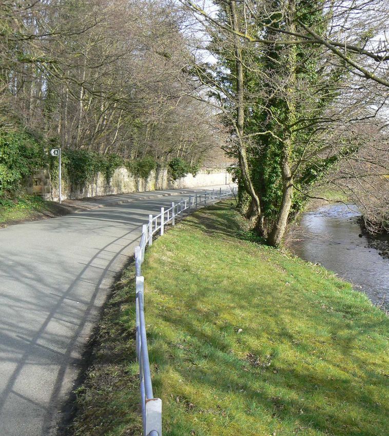
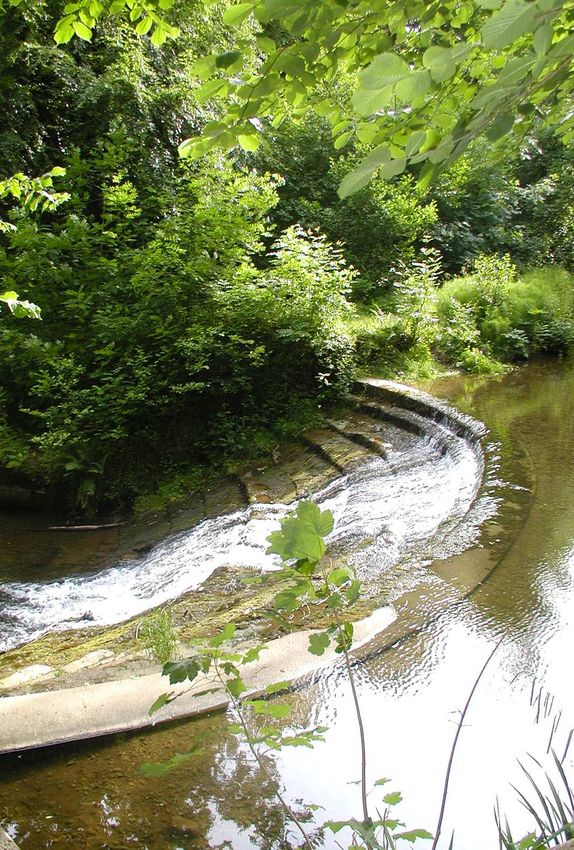
If your browser does not render page correctly, please read the page content below
Bersham
Conservation Area Assessment
and Management Plan

                   Adopted December 2009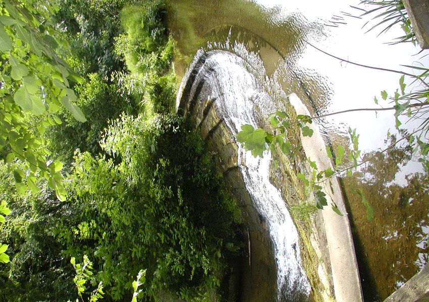
Contact
For more information or advice contact:
Chief Planning Officer
Planning Department
Wrexham County Borough Council
Lambpit Street
Wrexham
LL11 1AR
Telephone: 01978 292019
email: planning@wrexham.gov.uk
www.wrexham.gov.uk/planning

This document is available in welsh and in alternative formats on
request. It is also available on the Council’s website
Contents

Part I - Character Assessment                           1
1.0    Introduction                                     3
2.0    History and Development                          5
3.0    Summary of Special Character                     9
4.0    Character Areas                                  11
5.0    Summary of Negative Features                     24

Part II - Management Plan                               29
6.0    Enhancement Plan                                 28
7.0    Design Guidance                                  30
8.0    Conservation Area Controls                       32
9.0    Sources of Funding                               33

Appendix 1                                              34

Appendix 2                                              35

Appendix 3                                              36

Figures
Figure 1 Bersham Conservation Area                      2
Figure 2 Bersham 1849                                   5
Figure 3 Bersham Conservation Character Areas           9
Figure 4 The Lane from West Boundary to Mill Farm       12
Figure 5 The Area of the West Ironworks Site            15
Figure 6 The East Ironworks                             20
Figure 7 Bunker Hill and Y Ddol                         22
Ariel View of Bersham Conservation Area
Part I
Character Assessment

                    1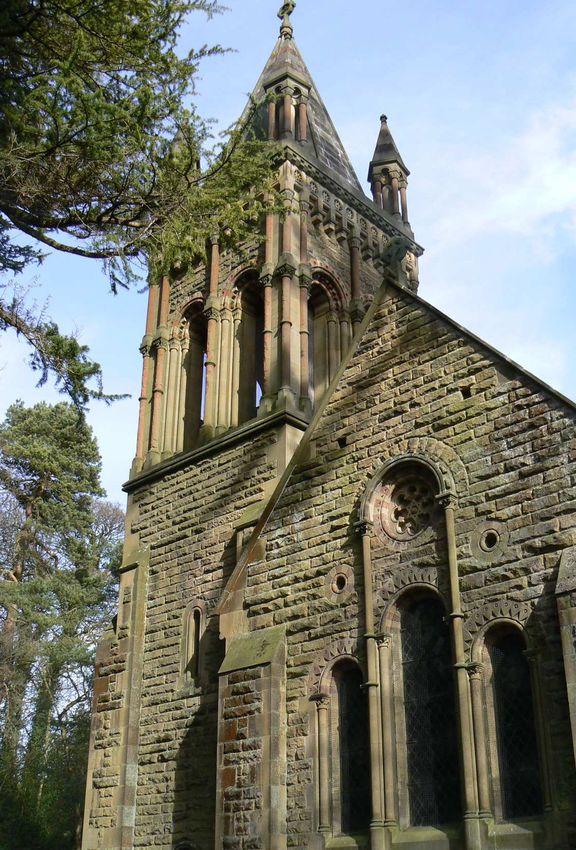
2
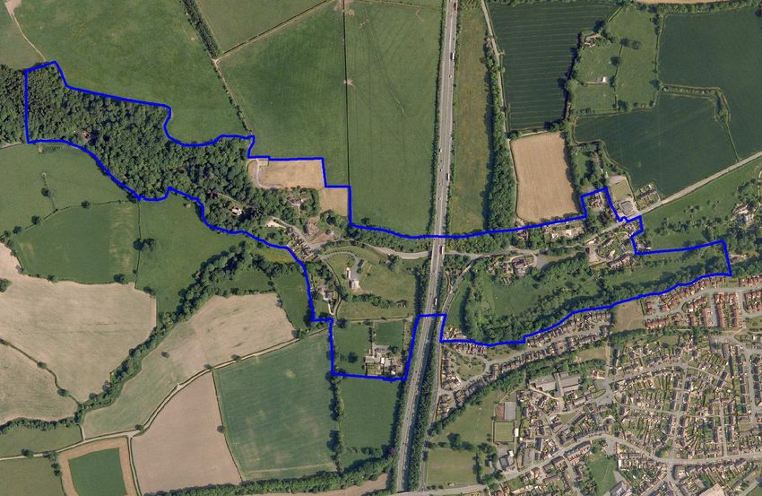
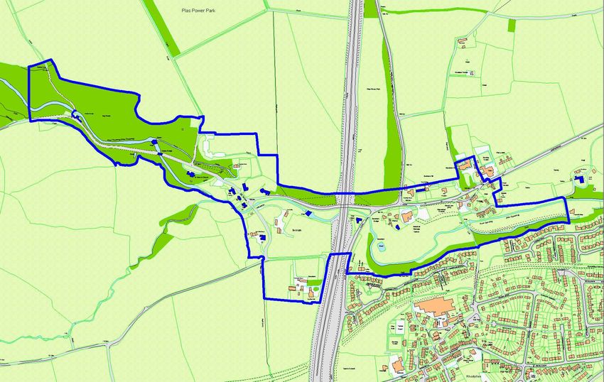
Figure 1 - Bersham Conservation Area
Ordnance Survey (mapping) © Crown copyright. All rights reserved. 100023429. 2010
introduction

                                                                                            1 Introduction
Conservation Area Designation                                       any building, feature or space should not be taken to imply
1.1 Section 69 of the Planning (Listed Buildings and                that it is of no interest.
Conservation Areas) Act 1990 requires Local Authorities to          Planning Context
identify "areas of special architectural or historic interest the
                                                                    1.4 This Statement should be read in conjunction with the
character or appearance of which it is desirable to preserve
                                                                    adopted Wrexham Unitary Development Plan 2005, and
or enhance" for designation as conservation areas.
                                                                    national planning policy guidance, in particular Welsh Office
Purpose                                                             Circular 61/96 Planning and the Historic Environment:
                                                                    Historic Buildings and Conservation Areas.
1.2 The purpose of a Conservation Area Assessment and
Management Plan is:                                                 Location
●     To provide a clear definition of an area's special            1.5 Bersham Conservation Area is situated approximately
      architectural or historic interest                            2.5 miles to the south west of Wrexham town centre and due
                                                                    north of the industrial settlement of Rhostyllen. The
●     To identify ways in which the unique characteristics
                                                                    Conservation Area is located within the wooded part of the
      can be preserved and enhanced through the
                                                                    upper reaches of the Clywedog valley, which runs from
      Enhancement Plan
                                                                    Minera to Wrexham. The influences of both the iron-works
●     To strengthen the justification for designation               and the nearby Plas Power Estate are evident in the
                                                                    development of the village, the architectural styles and
●     To create a clear context for future development in
                                                                    features, which afford Bersham its unique character. The
      accordance with conservation area policies in the
                                                                    majority of the Conservation Area lies within the designated
      development plan
                                                                    flood plain as identified by the Environment Agency.
●     To provide a vehicle for engagement and awareness
      raising                                                       Geology
                                                                    1.6 The geology of the area is a mix of Carboniferous coal
Bersham Conservation Area                                           deposits, sandstone and sand and gravel deposits. The lower
1.3 This Assessment and Management Plan aims to                     Clywedog valley cuts through a terrace of sands and gravels
promote and support developments that are in keeping with,          known as the Wrexham Delta Terrace.
or enhance, the character of the Bersham Conservation Area.         Consultation
It is not an attempt to stifle change. The aim is to strike a       1.7 The Community Councils, Council members and a
balance so that the interests of conservation are given their       range of organisations and groups with an interest in the
full weight against the needs for change and development.           historic environment and the local area were consulted on
Bersham Conservation Area was first designated in August            this document. Statutory bodies such as Cadw were also
1975 and its boundary amended in 2003. This document is             consulted. Public consultation was undertaken during
largely concerned with the reasons for designation, defining        October and November 2009 and included a public display
the qualities that make up its special architectural and            in the Lambpit Street building reception and Bersham Parish
historic interest, character and appearance. The omission of        Hall.
                                                                                                                             3
introduction

4
history and development

   Figure 2: Bersham 1849

  Ordnance Survey (mapping) © Crown copyright. All rights reserved. 100023429. 2010

                                                     2 History and Development
Early History                                                    Wrexham. It covered a much larger area than today,
2.1 Activity in the area can be traced to the Roman period       extending to Adwy'r Clawdd, Nant, Penygelli and
when lead and other minerals were mined in the Esclusham         Coedpoeth. Bersham village itself was formed from two
and Minera Mountains. Offa's Dyke, constructed in the 8th        adjacent groups of cottages known as Pentre Dybenni and
century, located a little way                                    Dol Cuhelyn.
to the west of the                                               Ironworks
Conservation Area, provides
                                                                 2.4 By the 17th century there
evidence of the Anglo Saxon
                                                                 was evidence of the existence
influence in the area. Built
                                                                 of several iron furnaces and
by King Offa of Mercia
                                                                 foundries along the Clywedog
                                                                 Valley. Bersham occupied an
                                                                 ideal location, lying in a central
                                     between 757 and 795, the
                                                                 position between the thriving
                                     dyke marked the political
                                                                 ports of Liverpool and Chester,
                                     frontier between Wales
                                                                 the mineral deposits of North
                                     and Mercia and may have
                                                                 Wales and the rich markets of
                                     acted as a military
                                                                 central England. The topography of the riverbank at
                                     defence. This section of
                                                                 Bersham was ideal for iron production, the natural cliff
                                     the Dyke, which runs
                                                                 formation allowing furnaces to be charged from the top and
                                     from North to South
                                                                 the molten metal to run off below at road level. The fast
Wales, is particularly well preserved. The ditch to the west
                                                                 flowing River Clywedog provided a power supply to drive
side and bank to the east are clearly visible.
                                                                 the water wheels and the surrounding countryside held
2.2 Anglo-Saxon influence is also seen in local place            plentiful supplies of wood to be used as fuel, as names such
names. 'Bers' is a common name for a township and still          as Coedpoeth meaning 'Hot Wood' attest to.
exists in the names of local farms. It is also an English
                                                                 2.5 Bersham's history and layout is closely tied to the
personal name with strong links to Cheshire. 'Ham' is an
                                                                 various ironworks which have existed there since the 17th
English word meaning settlement or manor. 'Esclus' is
                                                                 century. In 1774 John Wilkinson patented a highly
possibly an English corruption of the Welsh 'Ystlys' meaning
                                                                 successful machine for precision boring of cannon. In 1775
side or flank, referring to its position on a hillside.
                                                                 the distinctive octagonal building was built as a cannon
2.3 In medieval times Bersham formed part of the manor           foundry with 4 furnaces to cope with the increased demand
of Esclusham. This was later separated into Esclusham            for guns and cannon. Also in 1775 Wilkinson adapted the
above the dyke and Esclusham below the dyke. Bersham             boring machine to bore cylinders for the Boulton and Watt
then became its own separate township within the parish of       steam engine.

                                                                                                                          5
history and development

2.6 To supply power to turn the                                   2.9 The blast furnace on the west site of the village was
water wheels in his foundries                                     converted to a corn mill in 1829 and worked until 1933. It
Isaac Wilkinson (the father of                                    still contains a cast iron water wheel.
John Wilkinson) diverted the
                                                                  2.10 Esclusham Mill or Middle Mill, later known as the
course of the River Clywedog in
                                                                  Turkey Mill, is located just outside the Conservation Area to
1763 and built a number of weirs
                                                                  the East. It became famous for supplying high quality paper
along its length. The leats taken
                                                                  to prestigious customers. It was the first paper mill in
from the Caeau and East weirs
                                                                  Bersham built in 1801 by Edward Bozeley, who came to
are now dry but their banks are
                                                                  control all three Bersham mills. Laurel Grove, now a listed
still visible in Plas Power Woods
                                                                  building, was built at the same time for Bozeley to live in.
and the meadow leading to
                                                                  Its location close to the works enabled Bozeley to supervise
Papermill Cottage, formerly
                                                                  the mill 24 hours a day.
Turkey Mills.
                                                                  2.11 Bersham Paper Mill or Top Mill was established in
2.7  The many international conflicts of the latter half of the
                                                                  1818 on the site of the East Ironworks and used the same
                                       18th century, in
                                                                  waterwheel as the ironworks. The mill underwent many
                                       particular the American
                                                                  alterations and excavations show that a new mill was built
                                       War of Independence,
                                                                  about 1823. In 1829 this mill was sold to Thomas Fitzhugh
                                       ensured a strong
                                                                  of Plas Power. The 1850's saw fluctuating fortunes for
                                       demand for cannon
                                                                  Bersham Mill, from no activity in 1851, to a return to
                                       which meant the works
                                                                  production in 1856 to being used for the auction of straw and
                                       were extremely
                                                                  crops in 1859. A final attempt to run a paper mill was made
                                       prosperous between
photo courtesy of a                                               in 1863 when the Bersham Paper Company was set up.
                                       1777 and 1795. The
Brymbo Steelworks employee                                        Disputes over the validity of the lease, increasing
                                       physical constraints of
                                                                  competition and a decline in trade meant the company was
the Bersham site and increased competition from rival iron
                                                                  dissolved in 1866. The disused buildings were pulled down
works contributed to the decline of the site. John Wilkinson
                                                                  in 1869 by Thomas Fitzhugh.
turned his attention to his new site in Brymbo, acquired in
1792, until finally the foundry in Bersham closed in 1812.        The School
                                                                  2.12 The Bersham Mill
The Paper and Corn Mills                                          site was redeveloped to
2.8 Bersham retained some industry after the decline of the
                                                                  build the Bersham Boys
ironworks; principally paper and corn mills which re-used
                                                                  National School, designed
redundant ironwork buildings. Two paper mills were located
                                                                  by William Turner of
in the village during the 19th century to meet demand for
                                                                  Wrexham in 1876, which
paper which had increased due to the number of printers and
                                                                  later became the Bersham
publishers located in Wrexham.
                                                                  Junior Mixed County

   6
history and development
Primary School and eventually closed in 1961. The girls' The wall still exists today and is a very strong
school fell into disrepair and was demolished, whilst the characteristic of the area. William Lloyds' daughter, Mary
boys' school was converted in the early 1980's for its Fitzhugh inherited the estate, which was subsequently left to
present use as a Heritage Centre. her son Thomas Lloyd Fitzhugh who, in 1858, enlarged and
remodelled the house under the direction of the architect
The Plas Power Estate John Gibson. Around 1860 they also remodelled the
2.13 Plas Power Park lies directly to the north of the distinctive South Gate lodge and built the bridge and the
Conservation Area. The estate dates back to the middle of distinctive estate cottages of Mill Terrace. The Gate lodge
the 15th century when it was owned by Robert Bellot. In and Mill cottages are extremely picturesque and display the
the 17th century the Power family inherited the estate and decorative bargeboards and diamond lattice windows, which
changed the name to Plas Power. By 1747 it belonged to identify them as once belonging to Plas Power Estate. St
William Lloyd who, in that same year, demolished the Mary's Church, Grade II*, also known as Plas Power
original house and replaced it with a typically Georgian Chapel, was built by Thomas Fitzhugh in 1875, the tower
square mansion of red brick with stone dressings. He also was added later in 1893 in memory of Captain Godfrey
decided to enclose the parkland with a massive stone wall. Fitzhugh.
7history and development 8
summary of special character

 Figure 3: Bersham Conservation Character Areas

                                 The Lane from the west
                                  boundary to Mill Farm

                                                                                                     Bunkers Hill and Y Ddol

                                                                 The Area of the
                                                                West Ironworks Site

                                                                                                         The East Ironworks

 Ordnance Survey (mapping) © Crown copyright. All rights reserved. 100023429. 2010

                                     3 Summary of Special Character
3.1 The special character of the area has been greatly          contribute to the visual diversity of the area and assist in
influenced by the valley landscape setting and the historical   the integration of the built with the natural environment.
and architectural association with John Wilkinson's
ironworks and the Plas Power Estate. A number of factors        The wooded valley sides and banks of
contribute to the special character of the area and these are   the River Clywedog
now outlined below:                                             3.4 Plas Power Wood is a striking landscape feature that
                                                                dominates the
The Iron work buildings and sites                               upper part of the
3.2 The remains of Wilkinson's Ironworks are an                 Conservation
important link with                                             Area. It gives the
the area's industrial                                           site a feeling of
past. The old blast                                             enclosure and
furnace, now known                                              contributes to the
as The Mill, and the                                            setting of a
octagonal foundry,                                              number of
are both particular                                             buildings. It is a
landmark buildings,                                             designated wildlife site that contains ancient woodland
built of hand made                                              managed by the Woodland Trust. The Clywedog Trail runs
bricks in contrast to                                           through the wood, along the path of Wilkinson's wagon
other structures in the area.                                   way, originally used to transport raw materials to the works
The numerous bridges and remains of                             form the mines in Minera.

the river weirs, sluice gates and leats                         The strong
3.3   The weirs situated at various points along the River      architectural
                                       Clywedog contribute
                                       greatly to the           influence of the Plas
                                       character and            Power Estate
                                       distinctiveness of the   3.5 Bersham Lodge, St
                                       area. The differing      Mary's Church, and the Estate
                                       styles and varying       Cottages are landmark
                                       materials used in the    buildings creating a strong
                                       construction of the      sense of place and identity.
                                       bridges and weirs        The distinctive "Estate

                                                                                                                               9
summary of special character
architecture" style, comprising sandstone walling, slate In some places, stone boundary walls are softened by
roofing, heavy cast iron latticed windows and carved natural vegetation with hedges, grass verges and the
decorative barge-boards, is characteristic of the influence of absence of pavements and kerbs creating a distinctly rural
the Plas Power Estate. feel. The hedging consists of a variety of mixed indigenous
species including hawthorn, holly, hazel, yew and sycamore.
Boundary In the Ddôl area, Ruabon red engineering brick walls and
details cast iron railings and gates take precedence.
3.6 Sandstone
boundary walls of
The historic place, street and house
various types with names
differing capping styles 3.7 Various historic place names have survived (e.g.
are a common and Bunkers Hill, Ballistics Bank, The Smithy, Pentre Dybenni
and Y Ddôl).
distinctive feature of
the Conservation Area. Y Ddôl
In particular, the high 3.8 A compact area of high-density building set into the
boundary wall to the steep valley side close to the river, creating a sense of
Plas Power Estate compactness. Very characteristic of the 19th and 20th
dominates long century style industrial housing using terraces, semi-
stretches of the engineering red brick, slate roofs with red ridge tiles, brick
roadside. Elsewhere boundary walls and cast iron gates.
the walls are lower in
height creating a more open feel. There is a long stretch of
historic cast iron park railings along the roadside from
Bersham Lodge to the entrance to Bersham Bank. The
heavily decorated railings and gates surrounding Bersham
Lodge are particularly good examples.
10character areas
4 Character Areas
The Lane from the west boundary to Mill Farm
4.1 The Conservation Area can be sub-divided into 4 to the Estate. The dominant building materials are local
distinct character areas as described below: sandstone and slate.
The Lane from the west boundary to 4.3 From the west the high sandstone wall that surrounds
Plas Power is the dominant feature, running along the
Mill Farm roadside and enclosing the wood beyond.
4.2 The overall character of this part of the Conservation
Area is rural, with Plas 4.4 Further into the Conservation Area the valley
Power wood and the becomes narrow and deep and the trees, hedges, and grass
River Clywedog being verges lining the roadside create a strong feeling of
important landscape enclosure and a sense of arrival.
features. The valley 4.5 Bersham Lodge stands in a small clearing guarding
sides and the dense the former southern
woods on the north side entrance to the Plas
and hedges and trees to Power Estate. The
the south create a very Lodge is listed grade II
strong sense of enclosure and shadow. As a consequence, and has a date stone of
there are no vistas or glimpses of distant hills, surrounding 1833 but its character is
countryside or the adjacent Plas Power Estate. The lane is largely derived from
narrow with grass verges and a cast iron park railing runs remodelling work in
along the whole length c1860. The diamond
on the northern side. latticed windows and scalloped
The influence and bargeboards are architectural features
wealth of the Plas that appear regularly throughout the
Power Estate in the Conservation Area and
middle to late 19th make this building
century is evidenced in instantly recognisable as
the architecture of this an Estate cottage. The
character area. At this lodge is single storeyed,
time Thomas Fitzhugh was remodelling the Estate under displaying tooled,
the guidance of the architect John Gibson in an ornate coursed stonework
gothic style. There are 5 buildings or structures in this characteristic of the
area, all of which are listed and related to the Ironworks or earlier period while the
11character areas
Figure 4: The Lane from the west boundary to Mill Farm The Lane from West Boundary to Mill Farm
Listed Buildings
Important Approach
Significant View
Important Stone Boundary
Significant Wooded Area/Enclosure by trees
Big Wood Important railings
Potential Enhancement Area
Bersham
Lodge
River Clywedog
Caeau Bridge
St Mary’s Church
Ordnance Survey (mapping) © Crown copyright. All rights reserved. 100023429. 2010
rustic detail and applied timber decoration appear to be the and down river in the other. The bridge is listed grade II,
result of later of mid to late 18th
remodelling. The century date, single
roofing slates have been arched and of coursed,
laid in a decorative fish square rubble
scale pattern. The construction. Its
Lodge has group value parapet is formed from
with the heavy and massive ashlar blocks,
decorative cast iron which may have been
bridge, gates and quarried at nearby
railings that stand within its curtilage and contribute to its Minera, stepped out at each end to form terminal piers.
setting. These structures form part of the c1860 Estate
4.8 The weir may have medieval origins but it was used
remodelling work.
extensively in the 18th century as part of the water power
4.6 From here the road bends to follow the course of the system for the west ironworks and then for Bersham corn
river and then straightens up to allow an important view of mill. The sluice gate at top of the weir fed a leat, which
the River Clywedog curving away on its course through the served the Ironworks and corn mill. Although now dry, this
woods. The woods dominate the area and, together with can still be seen running alongside the path of the
the steep banks, hedges, overhanging Clywedog trail. The ornamental steps were created some
trees and grass verges, create a time between 1900 and 1911 perhaps to enhance its
strong rural character. Cast appearance as a feature within Plas Power Estate. The
iron park railings run stonework is slightly curved on plan, with abutment walls
along the entire of coursed and squared stone to either side. Just before the
length of the lane weir, a section of the Estate railings has been repaired and
from the Lodge to appear in stark
the entrance to contrast to those
Bersham Bank. damaged railings
immediately
4.7 Further
adjacent. The
along the lane in
repaired section
a clearing there is
provides a strong
the spectacular
and distinctive
view from Caeau
boundary and gives
Bridge to Caeau
the appearance of
weir in one direction
12character areas
exclusion, order and formality as originally intended by the Heavy wooden gates with open
Estate in this otherwise rural setting. lattice work and cast iron bolts guard
the entry to the Church, which is set
4.9 Beyond the bridge the sense of enclosure continues
in mature grounds with impressive
until we reach the Church. The simple rural boundary to St
specimen trees.
Mary's Church belies the ornate and exotic influences of its
design. Listed grade II*, it was designed by John Gibson 4.10 Beyond the Church the area
in 1875 for Thomas starts to open up with the driveway
Fitzhugh, for the use of to Bersham Bank to the north and the
the Plas Power household small parking area to the south.
and its dependants. The
4.11
pews still bear the names
Hidden in
of the other tenanted estate
the trees in
houses such as Bersham
an elevated
Bank, Bersham Smithy
position
and Mill Farm whose
overlooking
families worshipped here. The church is built in a
the old
Romanesque style, of rock faced rubble with the original
Bersham
zinc covering of the roof
Ironworks
renewed in 2008. The chevron
are Bersham Bank
mouldings and two tone bands
Cottages. Believed to be
which surround window and
of 18th century date, they
door arches are particularly
have been remodelled
distinctive features. The tower
and altered in the
was added in 1895, built in three
Victorian era and in more
stages and containing a bell
recent times. The pebble
chamber in the second stage, it
dashing in particular has altered their appearance, though
is surmounted by pinnacles at
the scalloped bargeboards herald their history as Estate
the four corners and has a short
cottages.
octagonal spire at its centre.
13character areas
The Area of the West Ironworks Site
4.12 The overall character of this area is rural, but in 4.13 To the west, the
contrast to the western elevation of the
previous character grade II listed Mill
area, it is much more forms a strong focal
open and expansive point, signifying a
allowing the definite change in
occasional glimpse of character from the
the countryside unspoilt rural character
beyond. The Smithy of the lane to a built up
set in its own open area. The stone boundary walls of The Mill and Mill
grounds and further up the hill above Ballistics Bank are Farmhouse add to this effect. There is a strong contrast
paddocks with mature hedgerows. The main architectural here between the mellow stone and brickwork of The Old
character is derived from the group of buildings around the Mill and the white painted render of Mill Farmhouse.
Mill farmhouse and the Old Foundry. Ranging in date
4.14 The site of the West
from c 1775 to 1860 a period that saw the expansion and
Iron works has seen many
decline of
changes and rebuilding
Wilkinson's
phases over the centuries.
Ironworks and the
Originally, in the 1780s the
remodelling and
rectangular, two-storey Mill
expansion of Plas
building was constructed as
Power Estate. The
a blast furnace, the remains of which can be seen at the rear
architecture is a
of the building. Then in
1828, after the closure of the
works it was converted into a
corn mill. It has a lower
mixture of 18th
storey built of stone with
century domestic and
rough rubble quoins, which
industrial and high
date to the 1780s, separated
Victorian gothic
from a brick upper storey by
revival, using a
an ashlar string-course. The west elevation has a dentilled
mixture of building
eaves line with a five-window range, displaying decorative
materials; sandstone,
cast iron traceried glazing bars and rusticated stone lintels.
brick, and painted
These decorative details add a delicate character to the
render.
14character areas
Figure 5: The Area of the West Ironworks Site Ordnance Survey (mapping) © Crown copyright.
Dra
in
All rights reserved. 100023429. 2010
Drai n
n
ai
Dr
in
Dra
M
Mill Farm
il T
er
ra
ce
The Smithy
Weir
Bridge Cottages
BershamBridge
The area of the
West Ironworks Site
The White House
Pond
Listed Buildings
Important Approach
Significant View
The Coach House Important Stone Boundary
Significant Wooded Area
/Enclosure by trees
A483
Important railings
Bryntirion Hall
Potential Enhancement Area
Buildings of Visual Interest
building's solid elevations. late 18th century, probably to provide accommodation for
The mill still contains a cast the ironworks accounts office. A small projection designed
iron water wheel with gears to house a cast iron safe in which Wilkinson kept the
and pinions and forms part of copper, silver and leather tokens paid to his workers, can
the Bersham Heritage Centre. still be seen to the left of the extended farmhouse. The
house was again extended and altered in the 19th century
this work probably carried out by the Plas Power Estate.
The slate roof has chimneys marking the gable ends of the
4.15 The immediately
original house, a design feature repeated in many buildings
recognisable octagonal cannon
in the area. Windows are timber casements with dormers
foundry building and the
displaying fretted bargeboards and
building next to it known as the
pendant finials. The entrance has a
fettling shop also form part of
six-panelled door with scalloped
the old Bersham Ironworks.
barrel canopy, carried on decorative
Both structures are listed grade
brackets. The late 18th century
II* and the former ironworks
extension has a plank door and a
site is a Scheduled Ancient
two light casement window to the
Monument. The eight-sided
lower storey; an original upper
brick structure and pyramidal
storey six over six pane sash
roof are landmark features.
window survives, cutting through a
They were built in c1775 as
raised stringcourse.
part of the expansion of the site due to the increased
demand for armaments after the outbreak of the American 4.17 The railings to the front of the Farmhouse contribute
War of Independence. The unusual shape was designed to to its setting and extend around the curtilages of Mill
accommodate a pivotal crane, which could swivel through Terrace, forming a visually cohesive link between these
360 degrees between the furnace and moulds. buildings.
4.16 On the opposite side of 4.18 Mill Terrace is an
the road stands Mill Farm extremely picturesque and
House and Mill Terrace prominent group of
cottages which together create buildings, forming a focal
a strong cohesive group and an point from the eastern
important building line. Mill approach. The terrace
farmhouse was probably built displays the distinctive
in the first half of the 18th century and was extended in the design details of the Plas
15character areas
Power Estate built of random squared rubble with diamond point. There is also an important view to the west from the
lattice windows and scalloped barge-boards. bridge over the field and beyond giving a rare glimpse of
Esclusham Mountain from within the Conservation Area.
4.19 Numbers 2 and 3 form a symmetrically planned pair
with paired advanced 4.23 The road over the bridge
central gables and continues as a narrow lane rising as
entrances recessed in it heads southward. From this point
Gothic arched porches to onwards the lane is enclosed on both
either side. Each gable has sides by a mature hedge. On the
a two light mullion and right the hedge is behind a low stone
transom window to the boundary wall belonging to The
ground floor and single White House, whilst on the left
transom light above. there is a grass verge for the whole
length of the lane which contributes
4.20 No's 4, 5 and 6 are symmetrical in composition with
to the intimate and unspoilt rural
advanced outer gables. No's 4 and 6 are entered from their
character.
sides, their return gables
having stone architraves 4.24 The White House is
and lean-to canopy shown on drawings of the
porches. The entrance to area in 1780 by William
No 5 is to the right of a Westaway Rowe and is
narrow central bay. known to have been
Windows are a occupied in 1829 by his
combination of single, son, who was an engineer
dual and triple lights with latticed glazing. in the Ironworks. It is now
shielded from roadside views by a very high hedge. Large
4.21 The garden to the
sandstone blocks with brick infill on this boundary show
south of Number 6 Mill
the position of the original entrance to the house. The
Terrace forms the
house is built of brick with roughcast render painted white
riverbank. It has an open
under a slate roof with decorative ridge tiles. The hilltop
rural character
position and the formal garden setting of the house reflect
uncluttered by walls and
its status. An impressive sycamore tree stands at the
fences, allowing views to
entrance and the extent of the garden is defined by a
the small field behind.
striking row of mature trees, which includes yew and
4.22 The small Mill Bridge is probably of 19th century Austrian Pine. There is a row of outbuildings within the
date, built of brick with a single arch. The railings on the curtilage of the house, possibly the former coachhouse or
bridge do not reflect its character nor do they blend in with stable, which has white painted walls and slate roofs and
the railings to Mill contributes to the setting of the house.
Terrace. From the bridge
4.25 At the top of the lane a public footpath continues
there are important views
south and from this point there is a view of the former
to the north taking in the
Bersham Colliery slagheap in nearby Rhostyllen. As an
Terrace, Mill Farmhouse
important part of the industrial history of the area, this is a
and the Foundry site,
significant view, which relates the village to its historic
with the end wall of the
context.
Mill being a strong focal
16character areas
4.26 Bryntirion Hall and its associated Coach House stand buildings that used to exist here in the 18th century. The
in an isolated position Smithy has been modernised and the grounds are
overlooking the valley. manicured which gives them a cultivated character in
They are situated within contrast to the rustic rural setting. Cannon balls of various
an attractive open sizes have been found on recent excavations in the grass
setting and within bank behind The Smithy. Previously known as Ballistics
considerable curtilages. Bank it was used to test cannon made at the foundry.
The lane has grass
4.28 In the grounds of
verges on both sides
The Smithy lies the East
and mature hedges.
Weir, constructed around
The area opposite the entrance to Bryntirion Hall allows
1779 by John Wilkinson
fine views north over the Conservation Area, and in
as part of his scheme to
particularly of The Smithy, Old Foundry Buildings and the
use water from the River
East Weir. Bryntirion
Clywedog to provide
Hall is known to have
power to his East
existed in 1823 when
Ironworks. It is one of
it was known simply
the few surviving
as Bryn Tirion which
features of the East
translates as Pleasant
Ironworks, supposedly
Hill, but may have
destroyed by gangs of
earlier origins and
men after an argument
links to the now
between John and
demolished Plas Cadwgan. It has since been remodelled,
William Wilkinson. The
possibly in the 1950's and is of brick construction but
weir has a stone incline with some concrete overlay. The
follows the original 'T' shaped floorplan. The gateposts and
retaining walls are of stone blocks, fixed together with cast
railings at the entrance are particularly grand, built of large
iron bolts.
sandstone blocks. The Coach House has been converted
into a residential dwelling with an extension to the building 4.29 Adjacent to the weir there is an informal lay-by area
and a separate driveway. Its central doorway is set into a regularly used by visitors
small projecting gable with a pitching eye above. who to enjoy the setting.
Decorative barge-boards link the building to others within
4.30 The north side of the
the Conservation Area.
road has a continuous
4.27 The Smithy, so called due to its use during the iron sandstone boundary wall,
work period, stands in its own considerable grounds. The which increases in height
green open site of today belies the extensive ironwork outside the foundry
17character areas
eastwards beyond the A483 fly-over and forms part of the 4.31 Hidden in the shadow of the A483 fly-over and
Plas Power Estate boundary. There is a narrow grass verge surrounded by mature trees are the 17th Century Bridge
at the base of this wall outside the foundry site, which Cottages. The cottages originally comprised five dwellings
softens its appearance but this character changes further associated with the iron works. Mid 19th century
east where the grass verge disappears and is replaced by a remodelling has resulted in dormer casement windows with
wide pavement with heavy latticed glazing bars, influences of the Plas Power
concrete kerb. This Estate. The cottages are
creates a strong urban an excellent example of
character and appearance, vernacular building, of
which is alien to the timber box frame
immediate rural area of construction with brick
the wooded bank beyond infill.
the wall and the riverbank
and green open space
opposite.
18character areas
The East Ironworks
4.32 The character of this part of the Conservation Area is Pleasant views are available from here down river and
predominantly rural, with the river and its meadows and the across the river meadows.
wooded valley sides to the south
4.36 The East Ironworks were
being strong landscape features. The
established during the rapid
archaeological remains of the
expansion of the Wilkinson era
ironworks and 19th century paper
but at its decline the majority
industry are important in shaping the
of the buildings were
form of this area.
demolished and their sites
4.33 The approach to the village from reused. Surviving road gulley
the south downhill along the B5098 gratings carrying the name of
affords an important view across the the Bersham Foundry and historical place names are the
valley to the opposite hillside and its only reminders of the area's industrial past.
backdrop of woodland. At the top of
4.37 A wide meander in the
the hill on the right stands Machine House, its name
River Clywedog encircles the
highlighting its associations
surviving buildings of Pentre
to the Ironworks. The house
Dybenni, the original core of
has been modernised and has
Bersham Village - The
lost much of its original form
Smithy Shop, Squires Cottage
and detail. Probably of brick
and The Heritage Centre.
construction, the property is
The Pentre street sign is still
now pebble-dashed and has
visible on the top right hand corner of the dwelling called
replacement windows throughout. A modern fence has
The Old Smithy Shop. This building probably dates back
been erected to the side of the property.
to the early 18th century, but has been extensively
4.34 Between Machine House and the modern semi- modernised with replacement windows and doors and
detached bungalows, Rustics and whitewashed render walling.
Pantiles, there is an access to a field
4.38 Pentre Dybenni Cottage is probably late 17th century
which allows for views along the
in date and has a slate roof and its walls have been rendered
meadow to the river.
in a similar style to The Old Smithy.
4.35 The single arch span Bersham
4.39 The grade II listed Squires' Cottage, originally known
Bridge over the river close to Bridge
as Ivy Cottage, was once inhabited by Daniel Ivy, a
Cottage is built of large blocks of
manager at Wilkinson's Ironworks. The 17th century
sandstone with sturdy metal railings.
cottage is timber framed, exposed at one gable end with
19character areas
Figure 6: The East Ironworks
Recreation
Ground
og
Bersham wed
r Cly
Bridge Rive
Industrial
Heritage
Centre
The East Ironworks
Listed Buildings
Important Approach
Significant View
Important Stone Boundary
Significant Wooded Area
/Enclosure by trees
Tree Preservation Order
Ordnance Survey (mapping) © Crown copyright. All rights reserved. 100023429. 2010 Buildings of Visual Interest
infill material of whitewashed rubble stone. The thatched running all the way to Turkey Mill. This stretch of the river
roof adds much charm to the and meadows is unspoilt by development.
building. A parallel modern
4.42 The boundary of the Conservation Area continues
extension has been built to the
along the wooded south bank of the river to just short of
rear in 1980, its size, form and
Papermill Cottage, (formerly Turkey Mills) in the east. An
design respecting the character
important view west up river is afforded from the historic
of the original building.
brick and stone bridge near Papermill Cottage . From here
4.40 The Heritage Centre was the boundary turns west into Y Ddôl along the riverbank
originally the Bersham Boys National School. Built in 1875 comprising an important open
it is of dressed sandstone and and unspoilt area. A former
displays classic Victorian course of the river can be seen
Gothic Revival architecture cutting into the bank to the
with pointed arches to north where there are mature
windows and doors and trees beyond the Conservation
buttresses to walls. Area boundary.
Entrances have original doors
and rectangular stone finials
above. The high pitched slate roof has coped gables with
corbelled kneelers. Windows are set back in their reveals
with stone mullions and hood moulds ending in square stops.
A later extension has been constructed to the rear, in a
similar style.
4.41 The Bersham Mill meadow (formerly
called Rolling
Mill Field and
Croft) has been
returned to nature
and is an
inaccessible
wildlife area of
grass and scrub.
To the east there is another impressive and
historic stone weir. Important far- reaching
views up and down river are available at the
bridge next to the weir. The line of the now dry
leat is visible as a low bank on the south side of the river
20character areas
Bunkers Hill and Y Ddôl
4.43 The overall character of this part of the Conservation 1785, the original 13 cottages housed some of the 400
Area is more urban due largely to the strong workforce of Wilkinson's Ironworks.
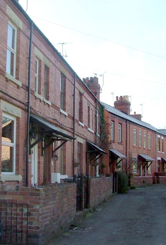
higher-density building layout. The
4.45 Set back from the road behind a line of mature ash
properties are mostly Victorian and
and poplar trees is Bersham Hall. The Hall, now named
Edwardian in style, built of mass
Prospects, has 16th and 17th century origins, evidenced by
produced products such as Ruabon
the discovery of the date 1584 on a staircase and the dates
red engineering bricks and terracotta
1640 and 1698 found
ridge tiles. The urban feeling also
externally. It was rebuilt in
derives from the absence of grass
1890 with Ruabon red brick
verges, with bituminous road
and now exhibits
surfacing and pavements dominating
architectural details of the
the streetscape. The topography
Victorian era. The initials
dictates the settlement pattern with buildings located on
C&M and JE and the date
two stepped levels with Bersham Road passing in between.
1840 can still be seen carved
A feeling of enclosure is created by this landscape form,
into the wall near the entrance. These are probably the
especially in Y Ddôl.
initials of the Edisbury family who lived at Bersham Hall
4.44 Bunkers Hill overlooks the Heritage Centre and around this period.
Pentre Dybenni. A sandstone boundary wall runs the whole
4.46 At the entrance to
length of the road between
Bersham Hall, seemingly
Brambley House and Bersham Hall
acting as its lodge stands
and is an important feature. At a
Bersham Hall Cottage.
point opposite the lane leading down
There is an inscription on
to Y Ddôl there is an historic water
the front, dated G.F. 1906.
trough in the wall, which was
The property has been rendered but is probably of Ruabon
probably for the use of
red brick construction with mock Tudor detail to the front.
travellers and their horses. On
Situated to the rear of the cottage is what was presumably
the hill are the recently built
the stable building, it is also
Brambley House and the New
built of Ruabon red brick
Bungalow. Between the two is
with a slate roof, crested
the site of Bunkers Hill
ridge tiles and decorative
Cottages, named after the first
finials at each end.
major battle in the American
War of Independence. Built in 4.47 Yew Tree House was
once partly used as a Post
21character areas
Figure 7: Bunkers Hill and Y Ddôl
Bunkers Hill and Y Ddôl
Listed Buildings
Bersham Hall
Important Approach
Important Stone Boundary
Chapel Terrace
Significant Wooded Area
/Enclosure by trees
Important Brick Boundary
Ddol
D Tree Preservation Order
s
The Beeches
lla
Brambley House
Vi
ee
Tr
Buildings of Visual Interest
w
Ye
Black Lion(
Recreation PH)
Ground
Weir
lywedog
River C
Industrial
Heritage
Centre
Ordnance Survey (mapping) © Crown copyright. All rights reserved. 100023429. 2010
Office. It has been modernised and extended and now has string course adds detail and character. There is a
concrete roof tiles, replacement doors and windows and decorative timber gable over upper windows, open on
modern gates. number one and infilled on number two. The original doors
have been lost but they retain their tall, narrow shape with
4.48 Further along Bersham Road Penny Cottage stands on
fanlights above. There is an original wrought iron gate with
the right hand side. It is
stone pillars to number two, and red and grey quarry tiles on
dated 1840 but has been
the short path to the doorway, which has a sandstone step.
significantly remodelled and
altered and has a brick wall 4.51 The Black Lion Public House
with timber panels to the was built pre 1840 by William
front boundary on Bersham Thomas as a private
Road. dwelling but by 1851 it
was in use as a
public house. The
4.49 The unobtrusive yellow brick
entrance to Chapel Terrace chimneys with
comprises of a high sandstone polychromatic
wall with cock and hen corbelling and
coping and a wooden decorative pots
panelled gate. The only are unusual for
features of Chapel Terrace the area and are
that can be seen from the signs of later
road are the substantial brick chimneys and a variety of remodelling. The
chimney pots. black painted cill band
and quoins gives
4.50 On the road leading down to Y Ddôl, Yew Tree Villas
definition to windows and
are highly prominent. The
corners. Windows are 16 paned
two Villas are built from
sashes with the top right window displaying a later horn
Ruabon Red Brick, two
detail. The open porch has a fish scale patterned roof,
storeyed to the front and
mirrored in other buildings in the area, a decorative finial
three to the rear due to their
and an open gable, similar to that on Yew Tree Villas. A
positioning on the
Ruabon red brick wall with half bell copings lines the
embankment. Windows are
roadside and links to a footpath, which leads to a bridge
Edwardian timber
over the weir. Steel railings along the remainder of this
casements, with four panes. They have stone cills and
boundary detract from the appearance of the lane.
lintels with a decorative motif on the lintel. A terracotta
22character areas
4.52 Ddôl Terrace is formed from two groups of dwellings, one more ornate than the other. The
terraces were built at different times but similar construction materials and design details provide
visual continuity and a strengthening of design cohesiveness. Substantial brick chimneys display a
decorative band of projecting bricks around the top. Some gateways retain the original cast iron
gates and quarry tiles on the path to the front door.
4.53 Numbers 21 to 24 Ddôl Terrace are of later construction. The original windows
have been replaced with PVCu alternatives. The strong vertical emphasis of the
fenestration line, together with stone window cills and lintels have been retained. The
black brick cornice and doorway porches give a horizontal emphasis, further
emphasised by the Ruabon red brick wall, with half bell terracotta coping stones,
in front of the properties. Numbers 22 and 23 have retained the original fish
scale patterned roof to their porches. Numbers 8 to 11 are of an earlier date
displaying added decoration in their design with motifs on the stone
window lintels, a distinctive brick cornice and a terracotta string-
course. The small private gardens to the front are retained
behind a brick wall which extends to Nos 16 and 16a
(Hillside). A wrought iron gate leads to a modernised
18th century workers cottage. The cottage has
been built to step up the bank, using the
natural topography of the land. The original
building sits in the middle of the group with
later extensions on either side.
23summary of negative features
5 Summary of Negative Features
5.1 A number of factors have been identified as causing Inappropriate Repair and
detriment to the visual quality and character of the area.
These include: Replacement of Boundary Features,
Gates and Railings
The Poor Condition 5.4 The removal or rebuilding of original or traditional
of the Cast Iron boundary walling, removal of hedges, railings and gates and
Park Railings their replacement with modern brick or timber fencing or
galvanised alternatives have had a detrimental impact on the
5.2 Sections of the Estate
character and appearance of the area. A modern post and
railings are missing, rusting
rail fence runs for the whole length of the grassy river bank
or damaged. As an
from the bridge near the entrance to The Smithy to Bridge
important boundary feature
Cottages under the fly-over. This fence is visually intrusive,
lining the approach into the Conservation Area from the
made of galvanised posts and
west, their repair and reinstatement would significantly
rails. Many modern
enhance the appearance of this character area as well as the
replacements can create a
setting of the neighbouring listed buildings.
more urban appearance,
Loss of Original Features inappropriate in the greater
5.3 Traditional materials and architectural details are being part of the Conservation Area,
lost through their removal or replacement with inappropriate whilst poorer quality
modern alternatives. For example, original or traditionally substitutes can diminish the
detailed timber windows and doors have been replaced with special appearance of the area. In some instances, walls
poorly detailed joinery or PVCu alternatives, slate roof have been repaired using a hard cement mortar, rather than a
coverings have been replaced with concrete tiles and softer, traditional lime and sand mortar. Over time this will
original lime finishes or previously exposed masonry have increase the rate of decay of the original masonry.
been covered with hard cement renders or pebble dash.
These are all examples of inappropriate alterations that
The A483 fly-over
5.5 The A483 fly-over is obviously a monumental
slowly erode the character and diminish the quality of the
intrusion into the village and has a negative effect on the
area.
character, appearance and tranquillity of the Conservation
Area. This modern bridge is testament to the sometimes-
brutal necessities of strategic planning. Surprisingly and
thankfully its visual impact is reduced by the fact that
certain views of it are concealed by the curvature of the
road and the trees along the riverbank when approaching
from the west.
24summary of negative features
Highway Treatments
5.6 A number of highway treatments have created an inappropriate urban feel in many parts of
the Conservation area which detract from its rural character, most notably:
● The wide pavement and concrete kerb on the lane opposite the Smithy
● The wide junctions between Bersham Road, Berse Lane and the village lane detract from
the rural character of the village; their dimensions are more akin to a trunk or main road
than a secondary road.
● The duplicated "dead end" road signs outside 2 Y Ddôl.
● Traffic calming measures along Bersham Road.
Extensions and Ancillary Structures
5.7 Later flat roofed extensions and garages do not reflect the quality of the area.
There are also many dilapidated sheds and other ancillary structures that make the
Conservation Area look untidy.
25summary of negative features 26
Part 2
Management Plan

             27
management plan
GENERAL PROPOSALS FOR PRESERVATION AND ENHANCEMENT
6.1
Preservation and Reinstatement of lost Features Traditional architectural details and local materials are
important to the architectural interest and value and
should be retained, repaired or reinstated where lost.
Boundary Details The total demolition or removal of traditional boundary
details will be resisted. The use of traditional methods of
construction and materials including the use of lime
mortar is encouraged in all schemes of repair,
reinstatement or new work.
Grass Verges Future Highway works should seek to retain these
features and where possible reinstate where lost. New
works to be designed in accordance with guidelines as set
out in Section 7.0 of this document.
New Development Development must respect the scale, design, proportions
and materials of surrounding architecture to strengthen the
cohesion of the street. It is crucial that the scale and
diversity of the surrounding architecture is respected and
that an imaginative and high quality design is employed.
Detailed design guidance is provided in Section 7.0 of this
document.
Highway Improvements Highway work should be designed in accordance with
guidelines as set out in Section 7.0 of this document.
Trees Trees which are considered to make a significant
contribution to the character and appearance of the area
have been identified on figures 3-7 of this document. The
unnecessary removal or works that may be considered
detrimental will be resisted. Where removal is essential
then an appropriate re-planting scheme will be
encouraged.
Archaeology Varying levels of archaeological mitigation may be
required in response to development proposals within the
historic core. Early consultation with the Clwyd-Powys
Archaeological Trust in relation to any proposed new
dwelling or extension is encouraged to prevent delay at
the application submission stage.
Street Clutter An Audit of road signage, markings and street furniture
will be undertaken during late 2010 to assess the number
of unnecessary elements as well as those detrimental to
the setting of important buildings and the street-scene in
general.
28management plan
ENHANCEMENT OPPORTUNITIES
6.2
The following have been identified as opportunities for the enhancement of the Conservation Area. The undertaking of
these works is dependent upon the availability of funding or grant assistance:
The Lane from the West Boundary to Mill Farm
ENHANCEMENT OPPORTUNITIES
6.2.1
RESPONSIBLE BODY-
Repair of park railings - This is an important boundary Private land owner
treatment that adds significant character to this area
within the Conservation Area and would benefit from
a comprehensive scheme of repair.
Enhancement of Car parking area - The area of the Private land owner
Church car park to the north and west of Bersham Bank
is one which neither enhances nor detracts from
character of the Conservation Area, but where there
might be some potential for further interpretation
and enhancement.
ENHANCEMENT OPPORTUNITIES
The Area of the West Ironworks Site
RESPONSIBLE BODY
6.2.2
Improvements to Bridge Railings - The appearance of the Transportation and Asset Management Department,
bridge would be enhanced by the replacement of the WCBC
steel railings with ones of more appropriate appearance,
preferably set to a lower level than currently existing to
provide continuity with the boundaries serving
Mill Farm and Mill Terrace.
Enhancement of Roadside lay-by - Whilst it is essential to Transportation and Asset Management Department,
retain an informal appearance, the current churned up WCBC
and muddy surface would benefit from some low-key
landscaping improvements.
Tree Planting between East Weir and fly-over - Private land-Owner
The planting of native tree species within this area would
enhance the appearance of this currently overgrown area
of land whilst at the same time assist in screening of
the fly-over.
29Design Guidance
7 Design Guidance
7.1 The character of the individual buildings and street and eaves detail and ornamentation is essential. Heights
elevations, which together form the Conservation Area, and shapes of roofs
derives from a number of factors to which the following are important; flat
design guidance relates. Within these parameters there is roofs are alien to
scope for high quality architectural invention, provided that local tradition and
this is sympathetic to the existing character in terms of the generally
following: unacceptable.
Chimney-stacks are
Scale important features
7.2 Restoration and re-development must respect of the roof-scape
traditional plot widths and avoid massive repetitive and and should be
unrelieved facades, which typify so many modern designs. retained even if no
longer required. Typically within the Conservation Area,
Proportion stacks are positioned at the gable ends of properties.
7.3 Older Where roofing materials are to be replaced they should
building styles match the colour, size and texture of the original. Roofs
followed should be roofed or re-roofed in traditional materials on a
traditional like for like basis where historically appropriate. If
systems of ventilation is required, this should be achieved by
proportion. In inconspicuous means. Under eaves ventilation would be
most of the acceptable, but visible roof vents would not. Dormers set
buildings within within the buildings eaves are common features within the
the Conservation Bersham Conservation Area.
Area, the relationship between windows, doors, floor
heights and the relationship of solid to void in the design of External Walls
elevations is crucial. Traditional proportions should be 7.6 Any alteration or repair to external walls should
emulated in new development. respect the existing
building materials
Building Line and match them in
7.4 Development will be required to conform to the texture, quality and
historic street pattern. colour. Every
effort should be
Roofs made to retain or
7.5 The roof-line is nearly always a dominant feature of a re-use facing
building and retention of the original shape, pitch, verge
30Design Guidance
brickwork or stonework, which must not be rendered, retained wherever possible as character features of the
pebble-dashed or painted. Re-pointing must be carried out building and the Conservation Area in general.
with a mortar to match the existing in colour, type and
texture and historically would have consisted of lime and Boundary Treatment
sand. Modern hard cement renders prevent the evaporation 7.11 The removal or
of moisture, which can accumulate between the wall and the alteration of boundary
render, causing damp internally and should be replaced with walls or railings will not
a lime alternative. be viewed favourably.
Repair should be carried
Rainwater Goods out using identical
7.7 Rainwater goods should be repaired if original or materials and in the same
reinstated in original materials. Plastic guttering is not style or bond and missing
appropriate to Listed Buildings and buildings in copings replaced to
Conservation Areas. It is not historically correct and it does match the existing. The use of a hard cement mortar to re-
not enhance a building's character. Cast iron guttering can point joints is unacceptable as it increases the rate of
last for a lifetime if properly maintained, repaired and deterioration of sandstone in particular.
installed.
Surfaces
Windows 7.12 The overuse of insensitive macadam finishes should be
7.8 These are important features and should be correctly avoided and the opportunity taken to lay traditional
proportioned, well related to each other and respect the materials, their colour, texture and pattern in sympathy with
existing openings. Any the character of the area and sensitive to adjacent buildings.
repair or replacement Existing areas of setts, stone kerbs and brick and clay
should always match the paviours, etc should be retained and repaired.
original, however,
retention must always be Highway Works
the first consideration. 7.13 Redundant or
This includes not only unnecessary street furniture
structural elements of the such as signs, bins or poles
window but also historic should be removed to reduce
glass and original the effects of street clutter.
window furniture. Particularly important is the method of Any historic features such as
opening, the recessed depth within the reveal and the street signs must be retained
sections of glazing bars. Sash and casement windows would and any new items such as
have been the typical style within this Conservation Area bollards and sign- posts, etc
with windows almost always having a vertical emphasis. must be carefully integrated
Replacement of timber or iron windows in a PVCu within the streetscape and
alternative, no matter what the pattern or finish, is respect adjacent buildings
unacceptable. All windows must have a traditional painted and the area as a whole. The
finish rather than a modern stained alternative. number and size of road
signs must be kept to a minimum and only illuminated where
Doors essential. Backing plates should be grey or black and
7.9 Original door-cases, luminous yellow must be avoided. Where road lines are
doors and door furniture essential they must be of a restricted width within the
should be retained wherever Conservation Area.
possible. Replacements must
match the original in Micro Energy Generation
proportion, style and materials 7.14 Whilst the use of micro energy generation systems is to
and should have a painted be encouraged, they will not be accepted where equipment is
finish. Details such as fixed to building frontages or main or visible elevations
panelling and fanlights are where they would have a negative visual impact upon the
vital elements in determining Conservation Area or where the fabric or setting of a Listed
appropriate replacement door Building is detrimentally affected.
types, which respect the age of
a building. Porches should be
designed within the overall
context and architectural style
of the building and in reference to any appropriate nearby
styles. They should not dominate the front elevation.
Ornamental Features
7.10 Features such as terracotta mouldings, figures,
inscriptions, railings, boundary details, etc. should be
31You can also read