BOUGHTON & DUNKIRK NEIGHBOURHOOD PLAN BACKGROUND DOCUMENT BD10 LANDSCAPE CHARACTER AREAS - Boughton and Dunkirk Neighbourhood Plan
←
→
Page content transcription
If your browser does not render page correctly, please read the page content below
BOUGHTON & DUNKIRK NEIGHBOURHOOD PLAN
BACKGROUND DOCUMENT BD10
LANDSCAPE CHARACTER AREAS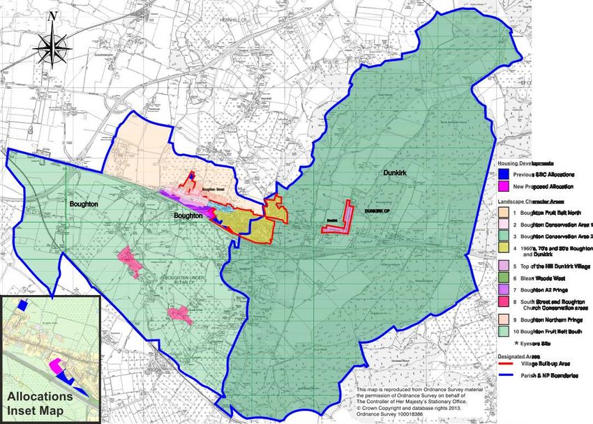
BOUGHTON & DUNKIRK NEIGHBOURHOOD PLAN
BACKGROUND DOCUMENT BD10
                                    A FT
LANDSCAPE CHARACTER AREAS
                               DR
                                           As part of the preparatory work for the
                                           Neighbourhood Plan, the team took a
                                           hard look at the area, seeking to
                                           identify and understand the important
                                           elements of the local landscape -
                                           natural features and the farming scene,
                                           as well as streets and buildings. We
                                           took into account earlier work for the
                                           Local Plan, some of which is included
                                           as Background Document 9.

                                           For purposes of the analysis, ten
                                           “character areas” were identified, as
                                           shown on this map

                           2
CHARACTER AREA 1
BOUGHTON FRUIT BELT NORTH A FT
DR
LANDSCAPE SUMMARY:
This is largely the valley area lying between Boughton and Staplestreet, lying beyond
Area 9, the sandy ridge immediately north of the development fronting The Street. It is
largely undeveloped, except for the complex of buildings around Nash Court, and
intensively farmed. The soil here is generally a mix of sand and loam with some clay.
Much of the land within this area is used for hops and fruit growing, and it also includes
the wide valley which separates the village from Nash Court which is an important part
of the strategic gap between Boughton, Faversham and the A2 dual carriageway; this
area is identified in the local plan studies as Grade 1 and Grade 2 farmland.
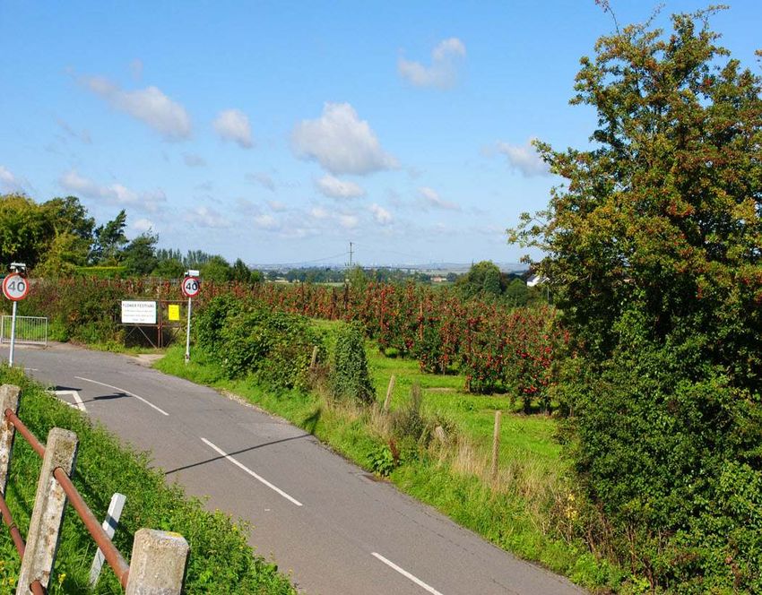
Fruit orchards are prevalent in the eastern part of this area, which has also been
identified in the local plan studies (Technical Paper 6) as an Area of High Landscape
Value – Swale Level, and in addition to its own inherent qualities drew attention to its
importance as the foreground setting of The Blean. The Babtie Report of 2003 judged
this area to be an Area of High Landscape Value due to its:
● Scenic quality comprising gently rolling topography and occasional steep slopes as
well as picturesque villages at Hernhill, Dargate and Staplestreet
● Sense of place retained as an area enclosed between the Blean, the A229 and the
● A2 and generally good landscape condition
● Historic landscape and farming features including shelterbelts and hedgerows, fruit
and hop production and traditional Kentish settlements and building styles.
There are a few oast houses bordering this area, which although converted into homes,
give the area a character that befits the description ‘Garden of England’. There are
several footpaths that cross the fruit belt giving walkers the opportunity to enjoy this
landscape.
3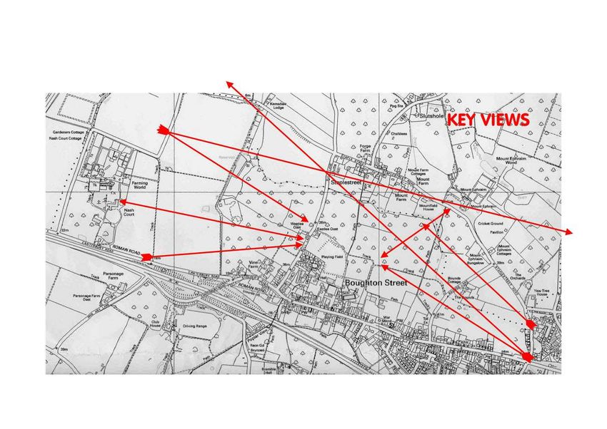
CHARACTER AREA 1
BOUGHTON FRUIT BELT NORTH                  A FT
                                      DR

This is an area of outstanding
views. To the east the wooded
slopes of the Forest of Blean
running generally north-south.
To the north beyond the Parish
boundary stream, the
prominent brick façade of
Mount Ephraim house and
beyond the tower of St
Michael’s church, Hernhill.

There are views to the north
across the Swale estuary to the
Isle of Sheppey and also to the
North Sea coast near
Whitstable.

To the west, across
an open valley is the brick
façade of Nash Court and
further west distant views of
Faversham and the creek-side
marshes.

                                  4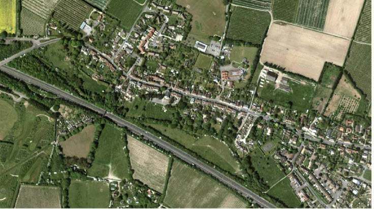
CHARACTER AREA 1
BOUGHTON FRUIT BELT NORTH            A FT
                                DR

                            5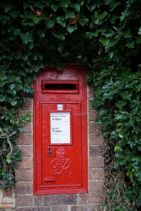
CHARACTER AREA 1
   BOUGHTON FRUIT BELT NORTH                                                              A FT
                                                                                     DR
LANDSCAPE KEY CHARACTERISTICS:
At its most easterly end, abutting the Dunkirk boundary at Staplestreet Road
the land comprises mature orchards of Gala apples with a small sheep-field
to the north of the track, and below an imposing farm-house and converted
oast-house, set on a small hillock. Moving westwards there is to the north of
the track a field of mature 15 year old blackcurrants ( used in the production
of Ribena) and to the south of the track an orchard of mature Bramley apples.
Continuing westward there is to the south of the track an established orchard
of Conference pears planted in 1965 and to the north of the track a field of
young blackcurrants. Further westward beyond a bisecting north-south
footpath a field of young blackcurrant bushes lies to the north, whilst to the
south up to the ridge, horse paddocks drop down to a fallow field on the edge
of which are a range of farm buildings and caravans for seasonal workers
(part of the “Northern Fringe” - Area 9). Further on an orchard of established
cherry trees under netting lies to the north of the track and is fronted by
hives of honeybees situated there to pollenate the fruit.
On westward to a T-junction of tracks an orchard of Victoria plum-trees runs
up to the border of the village recreation ground. North of a point where
the farm track meets the recreation ground perimeter road there is a mixed
field of asparagus and blackcurrant running down to the boundary stream.
Finally, further west across to the other side of Bull Lane a large hop garden
extends westward to Nash House estate and northwards to the stream at
the Boughton-Hernhill boundary.

                                                                                 6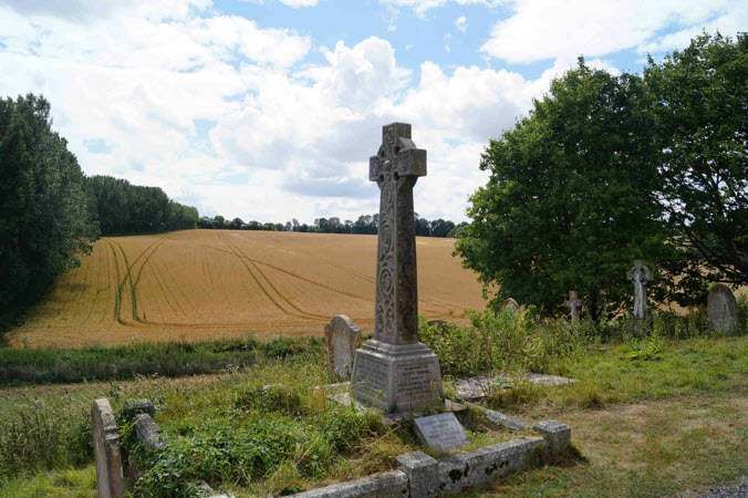
CHARACTER AREA 1
  BOUGHTON FRUIT BELT NORTH                                                                      A FT
                                                                                            DR
Once over the ridge behind Boughton village. there is the sense of being enclosed
in a shallow valley as the land rises very slightly at the edges of this area. Across
and at the boundaries of this ‘valley’ there are important views. To the west is
Nash Court; to the North are the houses on Staple Street and Mount Ephraim
house and gardens, which are a Conservation Area, for which the valley is part of
its setting. To the east are views towards houses in Dunkirk, and distant views of
Blean Woods.

The valley slope west of Bull Lane is an important component of the rural gap
between Faversham and Boughton, as well as the open setting of Boughton on
its western approach, and of Nash Court when looking out from the village.

Bull Lane itself takes on a wholly
rural character north of the
bungalows on its west side and
the junction with The Charltons
on the east side, which is
important in the view from Nash
Court.

There are several public
footpaths that cross this area,
providing long views north across
the orchards. There are several
areas where views of fruit
orchards can be seen. It is
important to retain these views and the orchards as they make an important
contribution to the character of this area.

                                                                                        7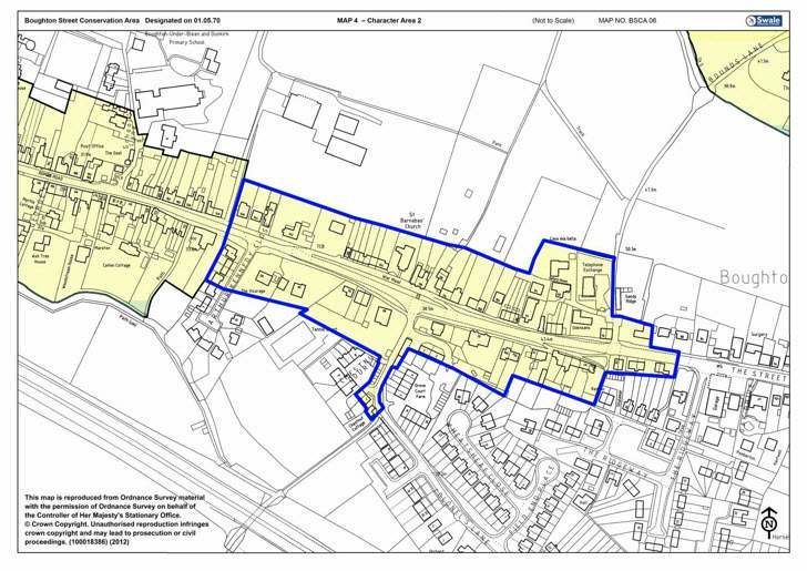
CHARACTER AREA 1
BOUGHTON FRUIT BELT NORTH                                                                                 A FT
                                                                                           DR
BUILT LANDSCAPE SUMMARY:
The two valleys are largely undeveloped, but are important components of the rural gap between Faversham and
Boughton, and of the setting of the Staple Street and Mount Ephraim Conservation Area in the adjoining Hernhill
parish, and also of Nash Court. Scattered individual buildings in open setting, and the complex of buildings that
include Nash Court and the adjacent former Farming World.

BUILT LANDSCAPE KEY CHARACTERISTICS:
There are few buildings within this valley , but some converted Oast houses, important legacies of heritage of the
Area and the complex of buildings that include Nash Court and the former Farming World..

To the south west of this area is the A2 dual carriageway and the busy roundabout, with a weighbridge and vehicle
checking station, a motorway scale “landscape” in its own right, with intrusive lighting, road signs and litter-prone
lay-bys and snack bar,

In the bottom of the valley west of Bull Lane is the former Southern Water site, now used for construction training,
which is reasonably well screened but is another discordant element in a otherwise agricultural landscape. To the
north of this, there are areas used for keeping horses, with a plethora of untidy fences and small buildings

On Bull Lane, a variety of signs and street furniture detract from the landscape

                                                                                      8
CHARACTER AREA 1
BOUGHTON FRUIT BELT NORTH                                                                             A FT
                                                                                       DR
DEVELOPMENT/DESIGN GUIDELINES:

   Conserve the area and its characteristic agricultural activity as part of the rural gap that separates Boughton
   from Faversham.
   Retention of the open nature of this area, including key views as indicated
   Conserve the intimate Landscape Character formed by the small/medium scale field pattern with its strong
   network of shelter belts and hedgerows, together with woodland, orchard and hop cover. Additionally, look
   for opportunities in localised denuded areas to reinstate such features.
   Development limited, in accordance with the Local Plan, to that which will contribute to protecting and
   where possible enhancing the intrinsic value, tranquillity and beauty of the countryside, its buildings and the
   vitality of rural communities.
   Conserve the distinctive landscape character formed at the boundaries with other character areas, such as
   where orchard and pasture meet, or form, the setting to the Blean Woods complex
   Use local and vernacular materials appropriate to the location, including stock bricks, peg tiles and flint
   Use traditional and native species for new hedgerows, mixed woodland and shaws
   As indicated in the recommendations for Area 9, look to maintain the rural character of Bull Lane and
   enhancement through residential allocation at Bull Lane, delivery of which should be controlled by a
   Development Brief that provides for particular, direct, active and well-articulated frontages to the playing
   fields.
   Strengthen the A2 landscaping and seek to reduce the impact of the road and its associated development
   Rationalise and renew street furniture and signs

                                                                                  9
CHARACTER AREA 2
BOUGHTON STREET CONSERVATION AREA 1
A fully illustrated Conservation Area Appraisal
for Boughton Street has been prepared by
Swale Borough Council, which will be added to the
background documents.
Extracts of the analysis are included
here.
The significance and special interest of Boughton Street
Conservation Area can be summarised as follows:
A linear village built on the Roman Watling Street which later
served the pilgrim route between London and Canterbury.
The rich variety of building styles, types, materials and forms
spanning several centuries.
The evidential value of a once vibrant village community with a
multitude of shops, places of worship, farms, schools, commerce
and coaching inns.
The tight-knit street frontages which open out to the east into a
wider more verdant street with some larger houses with more
substantial gardens.
Embankments, both grassy and brick built, often topped by
mature trees.
In order to describe the characteristics that
contribute to the special interest of the
conservation area it has been split into two
character areas. Any subdivision is to some
extent arbitrary but for the purposes of this
appraisal the area between Stockers Hill and the
Queen’s Head Inn is described in Area 1 and the
area between the Queen’s Head Inn and Bounds
Lane is described in Area 2.
10CHARACTER AREA 2
BOUGHTON STREET CONSERVATION AREA 1
LANDSCAPE SUMMARY:
This character area consists of the western part of The
Street from Stockers Hill to the Queen’s Head Inn.
It has a strong sense of place and a distinct identity
derived from the close-knit continuous
building frontages set at the back of pavement
or behind small front gardens.
It is the highway, the old Roman Watling Street,
which provides order, geometry and continuity
to the area. Minor tracks to the north and south
are generally small, frequently unmade and
unadopted, and serve only a handful of
properties.
Traffic noise from the dual carriageway to the
south also affects the ambiance of the place depending
on the time of day and the wind direction. The land slopes
steeply down to a stream that marks the edge of the Conservation Area, and the mixture of wooded areas and
pasture that provides a green buffer as well as forming the setting of the Conservation Area when viewed from
the south. This was recognised in the review of the boundaries of built up areas in the local plan (Technical Paper
3 - Document CD/087), the built up area boundary was drawn more tightly than hitherto “ in order to assist in
safeguarding the countryside from encroachment. “
Within this area it is the buildings that define space and dominate its character and appearance. They date largely
but not exclusively from the sixteenth to the nineteenth centuries and it is the juxtaposition of buildings of
different dates, styles and materials which adds richness, interest and complexity to the area.
11CHARACTER AREA 2
BOUGHTON STREET CONSERVATION AREA 1
BUILT LANDSCAPE SUMMARY:
Buildings are generally low in scale and domestic in character, only occasionally rising to three storeys in larger
properties, and have broad frontages to the street. This creates a rhythm to views along the street which is
articulated through changes in eaves line, architectural details and materials.
The buildings in Area 1 of the Conservation Area are varied in their dates of construction, materials and styles
reflecting the development of the local vernacular, changes in fashion and the growing influence of national styles
and their local adaptation. The buildings fall broadly into three groups. The earlier buildings are of the medieval or
post medieval periods. They are timber framed and appear relatively few in number. However many earlier
buildings are concealed behind later facades which were added for reasons of fashion or taste. The most
prominent of the earlier buildings is Tenterden House (number 209) with its continuous jetty and display of ogee
bracing on the first floor. Many others, such as Vine Farmhouse and number 211, conceal their medieval history
behind later brick elevations. Often it is the steeper roofs that indicate an earlier building behind a later façade.
Much rebuilding, re-facing and new building took place in the Georgian period, the second of the three groups.
Early Georgian examples are identified by their use of heavily detailed eaves cornices, such as the one at number
193, flush box sash windows as at number 159 and gauged brick arches with accentuated keystones at number 119
to 123. As the 18th century progressed classical detailing became more refined and there are many examples of
finer Georgian elevations with taller proportions, elegant door-cases and more refined details. Oak Lodge and 188
The Street exhibits a particularly fine Ionic door-cases but one does not have to look far to see good well
Preserved late Georgian houses and artisans’ cottages. There are less Regency period buildings but the 3
Storey “townhouses” at numbers 197 and 199 stand out because of their height and the architectural restraint in
their tall red brick elevations.
One or two buildings are in urgent need of repair, particularly the former Garden Hotel.
12CHARACTER AREA 2
A FT
DR
BOUGHTON STREET CONSERVATION AREA 1
The third major phase of building in this area is the Victorian period and includes several groups of terraced
houses such as numbers 179 to 185. Victorian houses tend to be taller than the Georgian examples and typically
have ornate or decorative stone dressings to the window and door openings as can be seen at Ebenezer Place
(numbers 202 to 208)or at number 203. Slate became the more common roofing material so roof pitches were
shallower in pitch. The Oast house on school Lane and the former Methodist Church (1844) were built in this
period.
Twentieth century buildings are uncommon in but for a couple of exceptions. Numbers 216 to 220 are a group of
three inter‐war houses; a pair of semi’s and a detached house which are half pebble‐dashed with gabled bay
windows, original front doors and tiled porches. These houses have hardly been altered with only one of the group
having its timber windows replaced, they add another architectural layer to the street and make a positive
contribution to the character of the conservation area. The tile hung building immediately to their west was
designed by Catell Skinner Architects in the 1990’s.
The number of good surviving historic shopfronts is a defining feature of
this Character Area. 18th and 19th century shopfronts, often added to the
fronts of residential properties, provide important evidential value as to
the commerce and economy of Boughton in past centuries. Evidence of a
wider range of shops and activities
historically exists in buildings many of which have been adapted to
accommodate new uses. In the last century the village sustained a
blacksmith, wheelwright, tailor, butcher, miller, a saddler, a private
gas works and a good number of hostelries and coaching inns. The
architectural detailing of shopfronts is often distinct and
characteristic of their respective periods. They are every bit as
important as other historic features such as windows and doors and
they add a richness and variety to the frontages which is important to
the area’s character and appearance.
13CHARACTER AREA 2
BOUGHTON STREET CONSERVATION AREA 1
DEVELOPMENT/DESIGN GUIDELINES:
� The preservation and enhancement of the area’s special interest and its character or appearance.
� The preservation or enhancement of the setting of
the conservation area and other designated
heritage assets, including the open and wooded
landscape between the rear of properties and the A2
� Improvement of “eyesore” sites such as the Garden
Hotel
� Review of the conservation area boundaries, to
include the setting of its western approach, include
areas around the school and rationalise to accord
with plot boundaries
� The safeguarding and better revealing the
significance of archaeology.
� Protection and enhancement of landmarks, views
and vistas within and without the conservation area.
� Safeguarding non-designated heritage assets which make a positive contribution to the significance of
the area.
� Safeguarding alleyways and lanes.
� Safeguarding significant spaces and trees.
� Promotion of high quality design which responds positively to context and the distinct characteristics of
the conservation area
14CHARACTER AREA 3
BOUGHTON STREET CONSERVATION AREA 2
LANDSCAPE SUMMARY:
This character area extends from The Queen's Head Inn to just east of Bounds Lane. This part of the
conservation area is characterised by its distinct grass and brick embankments with raised footways
to either side of the carriageway. From Scarbutts, footpaths, north and south of the Street, are
separated from the carriageway by grass embankments. The greenery of the verges and the
separation of pedestrians from the carriageway contribute to the distinct and rural character of the
Street and create a pleasant contrast to the appearance of area 1.
The Street broadens out in this part of the village and is no longer confined by continuous built up
frontages. Houses are set well back from the carriageway, resulting in a more rural and loose-knit
character. Immediately noticeable are the more generous plot sizes, handsome frontages and the
abundance of mature trees. Gaps between buildings allow the greenery of private gardens to
contribute to the street scene. These,combined with the greenery of the roadside verges,
embankments and highway trees lend a softer and
more verdant character to this part of the village.
A formal row of highway trees outside Grove Court
is a particularly important natural feature.
This more rural character prevails throughout Area
2 where there are stronger links with the wider
landscape outside the village. Unmade and informal
tracks which branch off The Street give access to
surrounding farmland and are an important
Part of Boughton’s history and character.
15CHARACTER AREA 3
BOUGHTON STREET CONSERVATION AREA 2
BUILT LANDSCAPE SUMMARY:
The area hosts some of the village's more significant Georgian houses which are given added stature by being
elevated to a greater or lesser extent above the level of passing traffic. Many buildings stand out in views up and
down The Street as a result of their position, their architectural status and their materials. With few exceptions
buildings are aligned east-west with only isolated examples of buildings with gables fronting the Street. St. Barnabas
Church and the former Congregational Church are notable examples of gable-fronted buildings.
The contrast between the small number of higher status houses and their close proximity to groups of small
artisans’ cottages adds variety and visual interest. Buildings range from the 17th century to the 20th century
and exhibit the full range of local vernacular materials and styles. Residential predominate, although many
buildings were once shops and businesses. Unlike Character Area 1, there is les evidence of the widespread former
commercial uses in the surviving buildings, although one or two houses no doubt served a shops in the past.
Numbers 118 and 120 retain what may well have served as shop-fronts and number 118 was apparently
Boughton’s first telephone exchange. A former oast house survives at number 114 showing the close relationship of
the village to the farmland round about.
Medieval buildings and buildings with early origins are much less apparent in Character Area
2 although the timber framed house at number 63a and 67 is a noticeable exception. This
part of the village is more renowned for its Georgian houses, some set directly onto the
footway and others behind neat garden enclosures with railings and gates. The earlier
Georgian houses typically have asymmetrical elevations and brick plat bands at first floor
level, as can be seen at numbers 108 and 110 or 84 (dated 1720).
There are two significant Georgian houses: Grove Court (number 81)to the south and
Scarbutts number 142) to the north. Scarbutts has the formal symmetry the elaborate Tuscan
door-case with fanlight and the railed front garden that one associates with polite Georgian
houses of the mid-18th century.
16CHARACTER AREA 3
BOUGHTON STREET CONSERVATION AREA 2
Grove Court is a little more antiquated but no less significant. It exhibits the use of mathematical tiles and more
backward looking casement windows. Both have former walled gardens alongside, both now built within,
But clear evidence of the houses’ status. The original extent of Scarbutts garden to the west is reflected in the
raised kerb to the highway, formed granite setts. The raised pavement has created an attractive edge to this part
of the road. The entrance to the house is acknowledged by steps in the raised kerb. Chestnut House is slightly
smaller though no less charming with its Doric door-case and two-storey bow windows.
Boughton was still clearly a fashionable place to build in the Victorian period when small villas, terraced houses
and some artisans’ cottages were added to the housing stock. Slate took the place of Kent peg tiles so roof pitches
became correspondingly shallower. Yellow stock brick, sometimes with red brick dressings became more
commonplace adding another contribution to Boughton’s varied palette of building materials.
Although some of the properties surrounding this area have high garden walls and greenery that hides buildings
and gardens from public view, there are also houses and cottages with frontages directly onto the Street, some
set behind small front gardens. These are bounded to the road or track ways by iron railings, picket fences or low
brick walls, all of which allow a degree of transparency to the street
further adding to the intimate and diverse character of the area.
There are a handful of 20th century residential infill developments but
few contribute positively to the character of the conservation area.
Number 72 is perhaps the exception, built in a Georgian style and
responding positively to local character in its use of railings and garden
walls.
17CHARACTER AREA 3
BOUGHTON STREET CONSERVATION AREA 2
DEVELOPMENT/DESIGN GUIDELINES:
● The preservation and enhancement of the area’s special interest and its character or appearance.
● The preservation or enhancement of the setting of the conservation area and other designated heritage assets.
● Improvement of “eyesore” sites
● The safeguarding and better revealing the significance of archaeology.
● Review of the conservation area boundaries, to rationalise to accord with plot boundaries
● Protection and enhancement of landmarks, views and vistas within and without the conservation area.
● Safeguarding non-designated heritage assets
which make a positive contribution to the
significance of the area.
● Safeguarding alleyways and lanes.
● Safeguarding significant spaces and trees.
● Promotion of high quality design which
responds positively to context and the distinct
characteristics of the conservation area.
18CHARACTER AREA 4
1960'S/ 70’S/ 80’S BOUGHTON AND DUNKIRK
LANDSCAPE SUMMARY:
This area consists largely of a number small estates and closes,
straddling the parish boundaries and reflecting gradual growth
eastwards, out to the bypass on the south side, and into the area of
former clay pits on the north side of the old A2. There is a mix of older
properties and infilling plots along the main road and in the Horselees
and former pottery areas.
LANDSCAPE KEY CHARACTERISTICS:
South of The Street, the land rises gently, so the estates in this area sit
on a low ridge, sloping back down to Colonels Lane and Horselees. North
of The Street, and east of Horselees the developed areas lie down below
the road, in the lee of wooded Boughton Hill. The southern side of the
area is bounded by and dominated by the steep embankment of the A2
dual carriageway bypass, with its discordant modern highway
characteristics, noise and lighting.
19CHARACTER AREA 4
1960'S/ 70’S/ 80’S BOUGHTON AND DUNKIRK
BUILT LANDSCAPE SUMMARY:
This area provides typical 1960's/ 1970’s/ 1980’s housing
with some slight variety in terms of facades. Practically all
residential area, with scout hut, play group buildings and
repair garage the only exceptions. For present day traffic
needs roads are probably too narrow, particularly where
houses lack off road parking facilities.
Houses are generally in good condition with most gardens
well kept. Mature bushes and trees evident in many
properties. Some mature hedges delineating properties
but streets are not tree lined - thus little shade offered.
Some important open green spaces, useful for recreation
as well as for amenity value, some public and some
private, with trees at junctions.
20CHARACTER AREA 4
1960'S/ 70’S/ 80’S BOUGHTON AND DUNKIRK
BUILT LANDSCAPE KEY CHARACTERISTICS:
Mainly Closes/Culs-de-Sac (6) and one through road. Pavements with dropped kerbs. Small front gardens with
paved drives and larger rear gardens. Some grassed areas with mature trees to create green spaces. Evidence
of increased on road parking where houses lack garages or drives. Roads often curved and very narrow in parts.
Mature bushes and trees evident in many properties. Some mature hedges delineating properties but most
streets are not tree lined - thus little shade offered.
Mainly semi-detached brick houses with built in garages and drives, though some older terraced properties in
St. Paul's and St. Peter's roads. All are two storeys with either hung tiling or weatherboarding upper facades. All
houses have tiled roofs. Older properties have chimneys. Windows tend to be metal framed and 3 paned (2
side and one main central) but bow-windows on Highview Rd and St. Paul's. Mixed doors, some with enclosed
porches. Consistent roofscape. There are no real focal points or particular views. Small network of footpaths
link different parts of the estates.
Weatherall Close is newest of these development areas and different in character – 23 chalet bungalows, some
with Juliet balconies, and front doors at the sides of the properties, and “shared space” highway layout, with
off-road parking. Two privately owned and gated orchards with mature fruit trees.
On the north side of the old A2 are the estates fed from the narrow and winding Staple Street Road and Dawes
Road, both of which contain some older properties and clues as to their origin as part of a productive tile and
pottery area in Victorian times. Infilling along these roads, particularly the most recent at Manor House, has
changed the character of these roads from country lanes to a more suburban feel.
Stoney Road is off Dawes Road and has a majority of 1960’s terraced, detached houses and detached and semi
detached bungalows. There is a row of 3 semi detached Victorian houses, originally in yellow brick with slate
roofs. At the end of Stoney Road, which is a dead end, is a detached house of brick, with a Kent peg tiled roof,
which looks to be Victorian but could be a lot older. All properties have off road parking, some with garages.
21CHARACTER AREA 4
1960'S/ 70’S/ 80’S BOUGHTON AND DUNKIRK
There is a large paddock on this road and most houses have front gardens, some with trees, shrubs and
hedges, making a very pleasant road.
Berkeley Close is a 1960s cul- de- sac off Stoney Road. The close consists of detached bungalows, terraced and
semi detached houses. Some are built in brick with white clapboard to the upper part of the houses. Others
are also built in brick but have dark red hanging tiles. Most houses have dark brown clay/concrete roofs. All
houses have front gardens, garages and off road parking. Only one house in the road appears to be Victorian,
which is built in red brick and Kent peg tiles. Next to it is a footpath, which leads to Staple Street Road. There
is another path at the bottom of Berkeley Close that leads to Stoney Road and Dawes Road.
Fernleigh Close is a small 1960s cul- de- sac also off Stoney Road and parallel to Berkeley Close. The close has
detached and semi detached bungalows in a dark brick (a few in red brick) and dark brown clay/concrete roof
tiles. All properties have small front gardens with garages and off road parking.
Background Noise of traffic from A2 dual carriageway from most parts of the area.
DEVELOPMENT/DESIGN GUIDELINES:
● �
Protect and enhance incidental open spaces
● �
Where infilling and subdivision of plots take place, ensure more adequate parking standards
● �
Provide more off-road parking, and better regulate on-street parking to achieve better safety
and less nuisance
● �
Rationalise and renew street furniture
22CHARACTER AREA 5
TOP OF THE HILL DUNKIRK VILLAGE
LANDSCAPE SUMMARY:
The top part of Dunkirk Village is a modest settlement based round the junction of the former A2 and Courtenay
Road, where the land levels off at the top of Boughton Hill. Much of the land is clay which makes drainage an issue
for both the built and natural landscape.
It is comprised in the main of 20th century residential dwellings, and a Victorian Church and school (now closed), a
small number of Victorian red brick cottages and farm buildings. The main road passing through the village is the
old A2 and it still has the feel and scale of a major route, remote from Boughton and the rest of Dunkirk parish ,
and a sense of height with long views afforded from Courtenay Road out over the surrounding landscape and to the
sea to the north. To the east of the village, there is a small but busy trading estate and other commercial premises.
The landscape here is dominated by the Blean Woods and the Grade II listed WWII transmitter tower, which played
an important role in Britain’s defence during WWII, and which extends to 360 feet in height. The mast is associated
with an extensive Chain Home Radar Station, now a Scheduled Monument, originally consisting of 8 transmitter
towers, only one of which survives as a listed building, and a compound which has fallen into neglect. The
Scheduled Ancient Monument is located to the rear of the properties along the western side of Courtenay Road
and the rear of properties along London Road.
Outside the compound a number of other Scheduled Monuments from this period survive including a couple of air
raid shelters and a brick built ammunition store on the edge of Bossenden Wood. There is a converted Bofors
Tower to the West in Clay Pits Wood.
23CHARACTER AREA 5
TOP OF THE HILL DUNKIRK VILLAGE
LANDSCAPE KEY
CHARACTERISTICS:
● Modest–scaled main road hamlet
● Victorian Church, School and mainly 20th
Century residential properties on former
A2
● Listed Transmitter Tower and extensive
Radar Station Scheduled Monument
● Historical associations with Courtenay
Rebellion
● Sense of separation from the rest of the
village and of height, with long open views
to the north out to sea and across to The
Blean Woods to the east.
24CHARACTER AREA 5
TOP OF THE HILL DUNKIRK VILLAGE
BUILT LANDSCAPE SUMMARY:
Courtenay Road is the more extensively developed of the two roads in this LCA. Despite an overall low
density character, there are two distinct sides to the road. On the western side, the dominant style is one
of semi-detached bungalows. Nearly all have uPVC replacement casement windows and doors, and
concrete tiled roofs with chimneys. All have off-street parking, many with garages set behind the
properties, and open front gardens bounded by low walls and hedging.
Behind the houses is the remnants of the WW2 radar station and a tall mast, with a number of
telecommunication aerial. Part of the site is a listed Ancient Monument, and the mast is a prominent
feature seen for some miles around.
At the northern end of the road is a plant nursery, and a football field, supported by the Parish Council.
The eastern side of the road has a mix of dwelling sizes and styles with a dominance of yellow stock brick
as a building material. As with the western side, dwellings are set back from the road behind front
gardens, low walls, hedging and some picket fencing. A small garage court is located behind the housing
mid-way along the road.
London Road is the original A2 London to Dover road. Development here largely fronts the northern side
of the road and comprises a small number of residential properties with long drives and large front
gardens bordered by mature, high hedges and fences. The former Dunkirk Village School, which closed in
2008, is also found here and like the church has now been converted to residential use, with a a small
development of houses on the former schoolyard. Adjacent to them is the
later Courtenay House, a late Victorian mansion now converted into flats.
Much of the rest of the buildings in that area are architecturally
undistinguished, built in the 1930s through until the 1960s but they are
uniformly set well back from the road with spacious and cultivated front
gardens filled with trees and shrubs.
On the South side of London Road lie the new Dunkirk village hall, two well
integrated gypsy pitches, stables and paddocks for some 8-10 horses, and a
church conversion. (Whilst some of the church curtilage is now private
garden, there are a number of graves that people still visit. There is a
memorial stone to the fallen where annual services still take place).
25CHARACTER AREA 5
TOP OF THE HILL DUNKIRK VILLAGE
BUILT LANDSCAPE KEY CHARACTERISTICS:
● Low density residential development
● Long front gardens, off street parking
● Yellow stock brick, pitched roofs predominantly concrete tiled but with slate
● Vegetated boundary treatment.
● Church and School, closed, conversion to residential use
● Tall mast and remnants of radar station.
DEVELOPMENT/DESIGN GUIDELINES
Conserve the relationship of the village with the wider Blean Woods complex.
Development limited, in accordance with the Local Plan, to “development on minor infill and redevelopment
sites within the built up area boundaries where compatible with the settlement's character, amenity, heritage
or biodiversity value. On sites adjacent to a built up area boundary, related to the existing settlement pattern
and the character of the surrounding countryside, modest development will be permitted that meets a
recognised community need that cannot be met elsewhere and reinforces or enhances the settlements
sustainable characteristics”
Use local and vernacular materials appropriate to the location, including stock bricks, peg tiles and flint
26CHARACTER AREA 6
BLEAN WOODS WEST
LANDSCAPE SUMMARY:
Blean Woods West forms part of an extensive band of ancient woodland, formed of mixed coppice with oak standards,
sweet chestnut coppice and conifer plantations known as The Blean, which extends eastwards into adjoining
Canterbury District. The Blean supports one of the largest and most important areas of continuous woodland in the
UK. Ancient trees are found here amongst the enclosed pasture and arable fields which also characterise this Landscape
Character Area. Much of the land is clay which makes drainage an issue for both the built and natural landscape. The
diverse ground flora includes some species indicative of a long history of woodland cover, while the area is also noted
for birdlife, with over 50 species of breeding bird having been recorded, and for its invertebrate interest with nationally
rare species of butterflies such as the heath fritillary. Its international and national significance is recognized by its
designation as an SAC and a National Nature Reserve and by the three SSSI’s which it supports.
The land rises steeply on its western boundary from 40 to 124m. Similarly steep slopes are found at the southern and
northern boundaries; elsewhere the ground is gently sloping and rounded. An outcrop of London clay defines the
area. The soils found here are slowly permeable and seasonally waterlogged. On the steeper peripheral slopes small
areas of more fertile loamy soils overlay the clayey base soils.
The Blean’s westernmost extent falls within the Boughton and Dunkirk Neighbourhood Plan area and contains part
of the Church Woods SSSI as well as three woodland Local Wildlife Sites: Blean Woods South, Blean Woods Harbledown
to Dunkirk, and Blean Wood West and Holly Hill. These sites form the largest blocks of ancient woodland habitat in
Swale Borough and are thus a very important part of the strategic habitat network here. The woods (from North to
South) are Victory Wood, Blean Wood, North Bishopden Wood, Bossenden Wood, Clay Pits Wood, Brotherhood wood,
Fishpond Wood, Court Wood, Denstead Wood, Joan Beech Wood, Goulds Wood and Bower Wood.
The unusual close proximity of The Blean to the sea creates a distinctive sense of place, which is unique within the
context of the Kent landscape. From the high vantage points views extend to Whitstable and Seasalter in the North
East, Sheppey and the Swale to the North and North West. This LCA is bisected by the A2, with all its attendant highway
landscape and intrusion of commercial development at Gate Services and along the old A2 towards Dunkirk village.
27CHARACTER AREA 6
BLEAN WOODS WEST
The few roads are narrow and often enclosed by hedgerows. Much of the rest of the field areas are defined by post
and wire fences or ‘shaves’ of trees, linear plantings of oak, chestnut, hornbeam or conifers. The land that has been
cleared over the centuries is mainly left to pasture for sheep or cattle. These fields are notable for stands of single or
small clusters of mature oak trees to provide shade and shelter for the livestock. The land is mainly clay and slow
draining. In parts towards the east there has been some planting of fruit trees but their yields have not been high.
To the south of the A2, where there are loam soils and better drainage, there is a greater mix of arable land within
woodland settings, as well as cherry and apple orchards and increasing clearances of land to use for horse related
activities.
Winterbourne Quarry is a large scar on the landscape South and East of the area. This was included in the KCC Mineral
Reserves but has not been quarried for many years. This was given planning permission on 16 May 2013 for a single
dwelling and the S106 agreement included the transfer of woodland to The Woodland Trust or a similar body.
Victory Wood
Victory Wood is an excellent example of the high quality Green Infrastructure present in the Neighbourhood Plan Area.
Planted to commemorate the bicentenary of the Battle of Trafalgar, Victory Wood links two areas of ancient woodland.
The Woodland Trust bought the 140 hectare (345 acre) site in 2004, and planted 80 hectares (197 acres) of native broadleaf
trees along its southern boundary. Amongst the new woodland commemorative art work, including a statue of Nelson,
a Footprint of the Victory, and a Trafalgar battle are plan laid out in trees. The site has a good network of paths, including
a surfaced path suitable for wheelchairs and push-chairs, which starts at the car park. There is also an all-access route for
horse riders, pedestrians and off-road push bikes, although only horse riders are permitted to use it during spring and
summer.
28CHARACTER AREA 6
BLEAN WOODS WEST
LANDSCAPE KEY CHARACTERISTICS:
• Ancient woodland, internationally and nationally protected by SAC, NNR and SSSI designations, part of the
most extensive woodland in England.
• A strong sense of place, with a feeling of remoteness partly created by limited vehicular access along quiet
rural lanes.
• Enclosed landscape to the south of the A2
More open landscape west of the woods north of the A2, with long views from higher ground to the north
towards Whitstable, the Swale Estuary and the coast
• Erosion of woodland and pasture character by increasing clearances for the keeping of horses.
BUILT LANDSCAPE SUMMARY:
Buildings here are isolated within the extensive areas of woodland or grouped in sporadic short ribbons of
development along the narrow rural lanes. In contrast to the prevailing landscape character a larger grouping of
mixed land uses is found at the eastern edge of the Neighbourhood Area in the vicinity of the A2 and London Road,
including a number of commercial premises, a static caravan park, a disused lorry park and a large gypsy and
traveller site. South of the A2, the area includes the scattered clusters of development at Dunkirk Road South and
Rhode Common.
Although the majority of buildings found within this LCA are of mixed 20th century styles, adjacent woodland
screening means that they have only a moderate impact on the surrounding landscape. There remain a number of
historic farm buildings, including Victorian farm cottages and are of traditional design and scale, with local
materials, such as red or yellow stock brick and flint,. Traditional mature hedgerow boundary treatments are being
eroded by increasing use of post and wire fencing.
29CHARACTER AREA 6
BLEAN WOODS WEST
BUILT LANDSCAPE KEY CHARACTERISTICS:
● Built development along the old A2 and around Gate Services, but otherwise limited overall to isolated dwellings and
farm buildings, with clusters of development south of the A2
● Extensive network of mature hedging being eroded by increased usage of post and wire fencing, particularly for
internal field boundaries.
● Local Building materials here include red and yellow stock brick, with more limited use of brick and flint, peg tile and
slate roofs, paling or picket fencing and hedgerows. Weatherboarding is not part of the vernacular.
DEVELOPMENT/DESIGN GUIDELINES
The Western Blean woodland character should be conserved and reinforced.
● Conserve the largely undeveloped and heavily wooded character of the landscape which forms part of the wider
Blean Woods complex.
● Development limited, in accordance with the Local Plan, to that which will contribute to protecting and where
possible enhancing the intrinsic value, tranquillity and beauty of the countryside, its buildings and the vitality of rural
communities.
● Resist further woodland clearance - eg for horse related activities and grazing livestock.
● Create stronger ecological networks by linking ancient woodlands through new woodland planting and hedgerow
restoration in appropriate areas, whilst conserving key views over the northern marshes to Whitstable and the sea.
● Conserve the distinct and tranquil landscape character of ancient and semi-ancient woodland complex (including
ditches, streams and ponds, scrub, dry and wet heath), together with its setting of wood pasture, open slopes (inc.
views) and the rural character of the area’s network of narrow winding lanes, enclosed by mature hedgerows.
Additionally look for opportunities that would enable woodland to be created.
● Use local and vernacular materials appropriate to the location, including stock bricks, peg tiles and flint
● Use traditional and native species for new hedgerows, mixed woodland and shaws
30CHARACTER AREA 7
BOUGHTON A2 FRINGE
LANDSCAPE SUMMARY:
This is a long, narrow, heavily planted area, which runs along the northern edge of the A2 and which serves as a
landscape buffer between the dual carriageway to the south and the village and conservation area of Boughton,
located on higher ground immediately to the north. The ever-present traffic noise of the A2 dominates here.
The western half of this long linear LCA borders
the rear gardens of properties along the south
side of The Street. These typically enjoy lengthy
and well planted curtilages which drop
markedly away in level south towards a small
stream, which runs east west along the rear of
these gardens, and marks the northern boundary of
this LCA. Towards the eastern end, properties at Arthur
Kennedy Close, Chestnut Court and Colonels Lane have
smaller gardens. The character of the LCA is more open here with
fields of overgrown grassland with tall grasses and low level self-seeded
trees located on level ground to the rear of Chestnut Court and Colonels Lane and on
land to the south side of the stream alongside the A2.
The topography, together with extensive planting here, creates what would otherwise be a quiet, undeveloped,
rural character to the area if it wasn’t for the presence of the A2 which runs the length of its southern boundary.
Much of the land here is wooded, particularly at the western extent, along the stream and in the form of a dense
tree belt along the A2 margins. Species are mature and include oak, maple, beech and willow.
31CHARACTER AREA 7
BOUGHTON A2 FRINGE
Access to this LCA is limited to a number of unmade narrow tracks
which lead down between residential properties from The Street and
from Colonels Lane. These are public footpaths and currently largely
suitable only for pedestrian use. The Boughton Conservation Area
Appraisal describes these unmade narrow track ways, which survive
mostly at right angles to the Street, as a particularly distinctive feature
of the Conservation Area. These footpaths join with public footpath TR
614 which runs east west alongside the stream through this area. This
path leads to and connects with both the footbridge over the A2 at the
western end with the underpass under the dual carriageway at the
east. It is narrow and somewhat overgrown but clearly well-used,
affording an attractive verdant pedestrian circuit between the eastern
and western ends of Boughton village.
Two small residential allocations are proposed here in the submission
Local Plan at the eastern end of the Character Area in Colonels Lane,
immediately alongside the A2, with cumulative indicative capacity of
21 dwellings. Access to the larger of these sites will necessitate the
demolition of two cottages on Colonels Lane. In proposing residential
development here, the Borough Council has been satisfied that road
traffic noise is not an insurmountable issue.
32CHARACTER AREA 7
BOUGHTON A2 FRINGE
LANDSCAPE KEY CHARACTERISTICS:
● Traffic noise from A2 dominates here, and at the eastern end the A2 bypass
embankment is a dominant feature
● Area serves as an important landscape buffer between Boughton village and
Conservation Area and the A2
● Topography, planting and stream and culvert prevent regular vehicular
access
● Public footpath enhancement and improved maintenance needed to
increase attractiveness as a resource for walkers and dog walkers
● Mixed woodland and small areas of pasture, with opportunities to enhance
biodiversity
● Level open areas to the eastern end offer potential for limited infill
development subject to resolution of access and noise issues.
33CHARACTER AREA 7
BOUGHTON A2 FRINGE
DEVELOPMENT/DESIGN
GUIDELINES
The eastern part of this area falls within the built up area of
Boughton, as defined in the Local Plan inset map, and this area
includes the two areas allocated for residential use, immediately
alongside the A2, with cumulative indicative capacity of 21
dwellings. Access to the larger of these sites will necessitate the
demolition of two cottages on Colonels Lane. In proposing Extract of the Key to
residential development here, the Borough Council is satisfied the Proposals Maps
that road traffic noise is not an insurmountable issue.
Adjacent the larger site, and adjoining the built up area, is a
further area of relatively level land which might be considered
for development provided that a development brief for the two
areas combined could deal adequately with access and noise
issues.
The remainder of this area, both sides of the stream, is a mixture
of woodland and pasture, that forms a green buffer between the
conservation area and the A2 dual carriageway. It should be
protected from development, Public footpath enhanced and
maintenance improved to increase attractiveness as a resource
for walkers, with opportunities to enhance biodiversity
Bearing Fruits 2031 - The Swale Borough Local Plan Proposals Map, December 2014
34CHARACTER AREA 8
SOUTH STREET AND BOUGHTON CHURCH
CONSERVATION AREAS
LANDSCAPE SUMMARY:
These two small Conservation Areas are historic hamlets on South Street, one around
the Medieval church, manor and tithe barn, and the other around the junction with
North Lane. Conservation Area Appraisals are in course of preparation by Swale
Borough Council and these will be added to the background documents when
available.
Both areas sit within Character Area 10 (Boughton Fruit Belt South), so their setting
and surrounding landscape are a gently undulating landscape that steadily climbs
southwards and small to medium-scale orchards and large open arable fields. There
are significant local historical buildings along this ancient pilgrims’ route, including
hall houses, an ancient parish church, old school house, old vicarage, oast houses, Boughton Church
hop huts, and old farm buildings. A light and open route, South Street twists through Conservation Area
various vistas with good views elevations and fairly diverse natural habitats over
quite a short distance. Road boundaries vary, from open to adjacent farm land ,
hedged , old flint walls , old brick walls,
The setting and topography of the two conservation areas are quite different, The
South Street conservation area consists in the main of a loose-knit collection of fine
individual buildings along a lane set in an attractive valley. Boughton Church The
church and its collection of medieval and Georgian dwellings is a focal point for the
district. Views from the hills are rolling and spectacular. The walls throughout the
area add a particular beauty, with the church wall the longest flint wall in the
South Street
diocese. Conservation Area
35CHARACTER AREA 8
SOUTH STREET AND BOUGHTON CHURCH
CONSERVATION AREAS
BOUGHTON CHURCH KEY
CHARACTERISTICS:
• 13th Century Church, imposingly sited on a hill and centrepiece
of a medieval manor house complex including the manor, tithe
barn and associated buildings now all separate dwellings.
• Large and steeply sloping churchyard, with mature trees and
long flint walls
• Long views across the valley to the north
� Former vicarage, schoolhouse and additional farmhouses and
cottages.
BUILT LANDSCAPE SUMMARY:
Grade 1 Church, with stone and flint walls,tower and large
Kent peg tiled roof. Victorian Lych Gate and several hundred
gravestones of varying ages, some of them listed in their own
right.
Medieval, Georgian and Victorian buildings and cottages and
are of traditional design and scale, with local materials, such
as red or yellow stock brick and flint.
36CHARACTER AREA 8
SOUTH STREET AND BOUGHTON CHURCH
CONSERVATION AREAS
SOUTH STREET KEY CHARACTERISTICS:
• A loose-knit collection of fine individual buildings along a lane
set in an attractive valley.
• Setting and surrounding landscape are a gently undulating
landscape that steadily climbs southwards and small to
medium-scale orchards and large open arable fields.
Significant local historical buildings along this ancient pilgrims’
route, including hall houses, and also on North Lane.
BUILT LANDSCAPE SUMMARY:
A mix of Tudor, Georgian and Victorian buildings and cottages
of traditional design and scale, with local materials, such as
timber framing, red or yellow stock brick and flint, set in large
gardens with mature walls and hedgerow boundaries.
� Former pub and post office now converted to dwellings
A few derelict buildings - former village hall and oast house
37CHARACTER AREA 8
SOUTH STREET AND BOUGHTON CHURCH
CONSERVATION AREAS
DEVELOPMENT / DESIGN GUIDELINES:
● The preservation and enhancement of the area’s special interest
and its character or appearance.
● Development limited, in accordance with the Local Plan, to that
which will contribute to protecting and where possible enhancing
the intrinsic value, tranquillity and beauty of the countryside, its
buildings and the vitality of rural communities.
● The preservation or enhancement of the setting of the
conservation area and other designated heritage assets.
● Improvement of “eyesore” sites and restoration of original
features such as postbox and hoppers huts
● The safeguarding and better revealing the significance
ofarchaeology.
● Review of the conservation area boundaries, to rationalise to
reflect the contribution made by other areas and buildings
● Protection and enhancement of landmarks, views and vistas
within and without the conservation area.
● Safeguarding non-designated heritage assets which make a
positive contribution to the significance of the area.
● Safeguarding and proper management of the churchyard and
● its wildlife potential
● Safeguarding significant spaces and trees.
● Promotion of high quality design which responds positively to
context and the distinct characteristics of the conservation rea
38CHARACTER AREA 9
BOUGHTON NORTHERN FRINGE
LANDSCAPE SUMMARY:
Between the Boughton Street Conservation Area and the extensive fruit belts to the north of the village, this LCA comprises
an area of largely open land which enjoys a highly distinct landscape character. Land here slopes gently upwards towards the
ridgeline at its north-eastern end and the access road to the village hall, which arcs around the community playing fields at
the western end of the northern boundary. The ridge, the fruit growing orchards and the access road combine to create a
clear and well- defined boundary between this LCA and Boughton Fruit Belt North (LCA 1). There are significant long and
attractive views of the orchards to the north and to the sea from a number of vantage points which contribute to the open
character of this area.
Despite being located largely to the rear of the properties, including those along The Street and the residential development
of The Charltons on Bull Lane, this LCA has a strong landscape identity in its own right. There are The Charltons, Eastlea Oast
and a small grouping of houses adjacent to the primary school, but the area is dominated by and provides the principal
community facilities for, the village, and it is these land uses in particular which shape its character. The library, village hall
and the Boughton-under-Blean and Dunkirk Methodist Primary School and Magpies pre-school are all located here, alongside
playgrounds and playing fields. Societies based in the Village Hall include the Bowls Club, Boughton Players and the regular
lunch club, and there is a wide range of play equipment to suit all age groups Such facilities create an open and accessible
sense of place, used widely throughout the day and at weekends. This LCA is therefore a focal part of the Neighbourhood
Plan area as a whole, providing important amenities for the residents of both parishes.
The LCA also extends to the east of the primary school grounds to include a large fruit pickers compound, turkey shed farm
buildings, cold store and a paddock, all of which lie on the gently rising ground to the north of Character Area 2 of the
Boughton Street Conservation Area and to the south of the extensive fruit growing enterprises immediately to the north.
These premises are accessed by a narrow lane off The Street, and farm tracks. A public footpath serves also to mark the
eastern boundary of this LCA.
With the exception of the playing fields, this LCA is not covered by the AHLV (Swale level) landscape designation,
which otherwise abuts the village boundary of Boughton on its northern side.
39CHARACTER AREA 9
BOUGHTON NORTHERN FRINGE
LANDSCAPE KEY CHARACTERISTICS:
● Predominantly open landscape between the built up area of the village of Boughton and the intensive
fruit growing area to the north
● Small residential estate at The Charltons
● Clearly defined boundary with fruit belt to the north
● Significant cluster of community facilities here
● Long and attractive views particularly from the ridge over the orchards and fruit growing areas
● Largely outside the AHLV (Swale level) landscape designation
BUILT LANDSCAPE SUMMARY:
The lengthy southern boundary of this LCA is marked by the rear of properties in the Boughton Street Conservation
Area. However, due to the long linear nature of the plots here, and the fact that these buildings lie on lower ground
such buildings do not dominate the built landscape here. Instead the built landscape is weak and largely
characterised by the rather utilitarian municipal built forms of the community buildings and the stark edge provided
by the exposed rear elevations of the dwellings of The Charltons. At the eastern end the fruit pickers mobile homes,
turkey shed farm buildings and cold store are in poor condition and in bulk and massing present as discordant
features which contrast adversely with the built environment of the Conservation Area which they immediately
adjoin. On the north western corner of the LCA however Eastlea Oast provides a welcome though sadly limited
example of vernacular architecture and the materials particularly associated with the fruit growing parts of the
Neighbourhood Plan area.
40You can also read