DYNAMIX policy mix evaluation - Reducing land sealing in Germany
←
→
Page content transcription
If your browser does not render page correctly, please read the page content below
DYNAMIX policy mix
evaluation

Reducing land sealing in Germany

Case study: Reducing land sealing in Germany

AUTHOR(S)

Stephanie Wunder, Ecologic Institute

With contributions by:
Leonardo Mazza and Ana Faria Lopes, IEEP

Project coordination and editing provided by Ecologic Institute.
Front    page     photo:     http://www.allposters.com/-sp/Farm-Near-Maria-Gern-and-Watzmann-
Berchtesgadener-Land-Bavaria-Germany-Europe-Posters_i8938270_.htm

 Manuscript completed in July, 2013
 This document is available on the Internet at: http://dynamix-project.eu/results.

Front page photo: ©

ACKNOWLEDGEMENT & DISCLAIMER

The research leading to these results has received funding from the European Union FP7
ENV.2010.4.2.3-1 grant agreement n° 308674.

Neither the European Commission nor any person acting on behalf of the Commission is responsible for the
use which might be made of the following information. The views expressed in this publication are the sole
responsibility of the author and do not necessarily reflect the views of the European Commission.

Reproduction and translation for non-commercial purposes are authorized, provided the source is
acknowledged and the publisher is given prior notice and sent a copy.

DYNAMIX PROJECT PARTNERS

                                                                                                  Page ii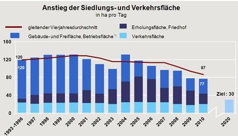
Reducing land sealing in Germany

Table of Contents

1     Resource/Issue                                                                                  5

2     Geographical area of policy mix coverage                                                        6

3     Policy context                                                                                  6

    3.1    Needs assessment: The environmental problem /resource challenge                            6

    3.2    Policy context and policy needs                                                           10

    3.3    Historical performance and projections into the future: Insights on decoupling            10

4     Drivers affecting change: resource use/ environmental issues                                   11

5     Situation/trend prior to introduction of policy mix                                            14

6     Description of policy mix(es)                                                                  14

    6a. Supplementary context questions including elements pertinent to paradigm discussions
    in DYNAMIX                                                                                       15

    6b. Instruments and orientation of policy mix                                                    16

    6c. Evolution of policy mix                                                                      23

7     Evaluation of policy mix: effectiveness (environmental sustainability)                         25

8     Evaluation of policy mix: efficiency (economic sustainability)                                 26

9     Evaluation of policy mix: welfare (social sustainability)                                      27

10    Overall assessment                                                                             28

11    Relevance to the EU and transferability                                                        29

12    Stakeholder contribution                                                                       30

13    References                                                                                     30

                                                                                              Page iii |
Case study: Reducing land sealing in Germany

List of Figures
Figure 1: Increase in German settlement and traffic areas in hectares per day, 1993-2010    7
Figure 2: Number of inhabitants in Germany, 2002-2011                                       8
Figure 3: German cumulative land take versus development of GDP, 2000-2012                 11
Figure 4: Average German living space per capita (m²), 1990-2011                           12
Figure 5: Position of landscape planning in the German planning system                     17
Figure 6: Plan products of landscape planning at the levels of overall spatial planning and
sectoral planning                                                                        17
Figure 7: Main elements of the German policy mix to reduce land take (Federal level)       23
Figure 8: Evolution of the German land policy mix, 1960s-1999                              24
Figure 9: Evolution of the German land policy mix, 2000-2013                               24

   1.

                                                                                       Page iv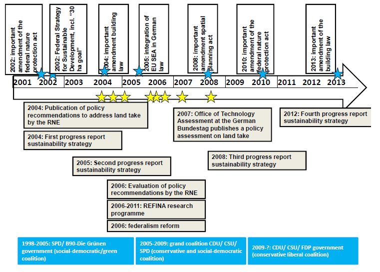
Reducing land sealing in Germany

1 Resource/Issue
Name of resource targeted (or focus of the case study, if the policy mix is broader than the
specific resource(s) we have decided to analyse):
Land is a limited resource and under pressure from increasing demands for agricultural and
forestry products as well as land requirements for settlements and infrastructure. The
sustainable use of land is key to the provision of ecosystem services, be it regulation of water
quality, availability of water resources, provision of food or storage of carbon in soils. Hence,
land is a key resource that needs to be protected.
An important driver that reduces the usability of land is urbanization and the increase of
settlement areas, often referred to as “land take”, defined as the “increase of urban,
commercial or industrial land in a given period” (European Commission 2013)1 or the increase
of settlement areas/artificial surfaces over time, usually at the expense of rural areas (Prokop
et al. 2011).2
This case study analyses land take in Germany and the policies that have been taken to
reduce additional land take.
The German case study will particularly focus on the reasons for the development of the
German key indicator “Increase in settlement and traffic areas in ha per day” (“Anstieg der
Siedlungs- und Verkehrsfläche in ha pro Tag”). Similar to the European definition “Settlement
and traffic areas” in Germany include not only built areas but also related recreational and
open spaces, cemeteries etc. (see Figure 1).
Glossary:

Within this case study different terms are used to describe the sustainability of land use in
Europe and Germany. The following list, taken from Prokop et al 2011 (p.23-25), will provide
an overview of the most important terms.
Most of the definitions described there were derived from the Environmental Assessment of
Soil for Monitoring project (ENVASSO) which published recommendations for the monitoring
of all soil threats including soil sealing. Terms related to urbanization processes were taken
from the European Environment Agencies (EEA) report “Urban Sprawl. The ignored
challenge” (Prokop et al. 2011).3

Artificial Surfaces
The term “artificial surface” is used in the CORINE Land Cover nomenclature and refers to
“continuous and discontinuous urban fabric (housing areas), industrial, commercial and
transport units, road and rail networks, dump sites and extraction sites, but also green urban
areas.

Settlement areas
Settlement areas are also known as “urban land” and “built-up land” and include areas for
housing, industrial and commercial activities, areas for health care, education, and nursing
infrastructure, traffic areas (streets and railways), cemeteries, recreational areas (parks and
sports grounds), and dumps sites. In local land use plans this category usually corresponds to
all land uses beyond agriculture, nature, forests, and water courses. Artificial surfaces and

                                                                                        Page 5 |
Case study: Reducing land sealing in Germany
settlement areas refer to the same structures, whereas settlement areas are defined by
spatial planners and artificial surfaces are measured by means of remote sensing.
Sealed soils
Sealed soils can be defined as the destruction or covering of soils by buildings, constructions
and layers of completely or partly impermeable artificial material (asphalt, concrete, etc.). It is
the most intense form of land take and is essentially an irreversible process. Sealed land is a
subset of the above mentioned category; i.e. land consumed by development of settlements,
infrastructure, and commercial and industrial areas. An indicator of the intensity of land take is
the proportion of the total built-up land area which is sealed.
Land take
Land take is also known as "urbanisation", "increase of artificial surfaces" and represents an
increase of settlement areas (or artificial surfaces) over time, usually at the expense of rural
areas. This process can result in an increase of scattered settlements in rural regions or in an
expansion of urban areas around an urban nucleus (urban sprawl). A clear distinction is
usually difficult to make.
Land use intensity
Land use intensity refers to the amount of artificial surface per capita. Low land use intensity
refers to a high amount of artificial surface per capita. Influencing factors for low land use
intensities are above all the amount of second homes, the dominance of small disperse
settlement structures and large touristic infrastructures. High land use intensity refers to a
small amount of artificial surface per capita, being mainly the result of very compact
settlement structures and high population density.
2 Geographical area of policy mix coverage
Country name, and region or city if appropriate (if policy mix is applied regionally or locally):
The case study analyses the policy mix that has been put in place to achieve a reduction in
additional land take in Germany. It focuses on the policies in place at the federal level, but
also gives illustrative examples from the states, regional and municipal levels (i.e. examples
from the “Bundesländer”, “Kreise”, “regionaler Planungsverbände”, “Gemeinden” etc.).
3 Policy context
3.1 Needs assessment: The environmental problem /resource
challenge
What is the environmental problem/concern (consider both quantity and quality), e.g. soil
erosion, excessive use of non-renewable or renewable resources and the crossing of
environmental thresholds/tipping points for impact, resource scarcity concerns?
Who is the target group affected that have been, are or will be beneficiaries of the policy
response?
Page 6Reducing land sealing in Germany
Germany covers an area of 357,111 km2. According to Prokop et al (2011) the amount of
artificial surface per capita is about 10 % below the EU average with 365 m² per inhabitant.
This can be explained with the high density of urban agglomerations: With 81.8 million
inhabitants (Nov. 2009), i.e. 229 inhabitants per km2, Germany is one of the most densely
populated countries in the EU (Prokop et al. 2011).4 Only Malta, the Netherlands, Belgium,
and the United Kingdom have higher population densities.
In recent years trends as regards land take in Germany were unsustainable: in 2011, each
day, 81 ha were lost to settlement and traffic areas (Bundesregierung 2013)5 (see Figure 1).
Approximately 43-50 % of the area lost was sealed (Bundesregierung 2012).6 In 2006 the
amount of sealed surface per capita in Germany amounted to 249 m² which is about 10 %
above the EU average (Prokop et al. 2011).7 This means that although the artificial surface
per capita is below the EU average, artificial surface is sealed to more intensively than in
other EU countries, resulting in a higher amount of sealed surface per capita.
Figure 1: Increase in German settlement and traffic areas in hectares per day, 1993-
2010
Increase in settlement and traffic areas
(in ha per day)
Four-year moving average Recreational space and cemeteries
Building and open space, commercial Transport
and industrial space (excl. open pit
operations)
Goal:
30
Source: Statistisches Bundesamt. 2011a. Statistik zum Flächenverbrauch. Wiesbaden accessed on 23.07.2013 at
http://www.netzwerk-laendlicher-raum.de/themen/flaechen/verbrauch/)
While the numbers in Figure 1 show that the additional land take per day is slowing down
(from more than 120 ha per day in 1993 to 81 ha a day in 2011), the actual overall land take
is nevertheless increasing (see Figure 3) and remains on a high leveli. A reversal of the trend
is not in sight. On the contrary, after a decrease of building permissions during the economic
recession in 2009, the economic recovery in 2011 lead again to an increase in the number of
building permissions and most projects are likely to be completed in the coming years
(Bundesregierung 2013).8
i
Between 1992 and 2007 settlement and traffic areas grew from 40305 km² to 46789 km² which equates an increase by 16,1%
(BfN 2008, p.4).
Page 7 |Case study: Reducing land sealing in Germany
Hence it is increasingly unlikely that the so called “30 hectare goal” (i.e. to restrict daily new
land take to 30 hectare per day by 2020) that has been nationally set by the government in
2002 within the Strategy for Sustainable Development will be achieved (Bundesregierung
2002, BfN 2009, Jörissen and Coenen 2007).9,10,11
The land take trend in Germany is even more unsustainable if one takes into account that
Germany´s population has been declining since the turn of the century (2002/2003) . These
two trends combined mean that overall the artificial surface/sealed surface per capita has
been rising every year since 2002 (see Figure 2).
Figure 2: Number of inhabitants in Germany, 2002-2011
Number of inhabitants (2002-2011)
83000000
82500000
82000000
81500000
81000000
80500000
80000000
Source: Statistisches Bundesamt. 2013b. Bevölkerung und Erwerbstätigkeit - Vorläufige Ergebnisse der
Bevölkerungsfortschreibung auf Grundlage des Zensus 2011, page 11 (accessed on 23.07.2013 at
http://de.statista.com/statistik/daten/studie/1217/umfrage/Zahl-der-Einwohner-in-Deutschland/)
Are there any economic or social problems related to the issue and environmental problems –
e.g. is there important price volatility, (risk of) unavailability of resources for the economy or
society?
The negative environmental consequences of land take are manifold as it affects the
ecosystem services provided by soils, particularly:
provision of food and raw materials: soil underpins 90 % of all human food, fibre, and
fuel and is essential for water and ecosystem health (EEA 2011);12
storage of carbon in soils, thereby contributing to a potential slowing of climate
change: according to the EEA (2011) Europe's soils store about 73 to 79 billion tonnes
of carbon;
archive for both natural and cultural history;
support of human settlements, infrastructure and recreation;
element of cultural heritage through the maintenance of landscapes;
regulation of water quality/ filtering;
water retention;
pollutant degradation;
nutrient cycling;
provision of habitats for flora and fauna;
genetic reserve.
Page 8Reducing land sealing in Germany
More specifically, soil sealing is a strong intervention in soil biology including soil organisms,
as it reduces the groundwater recharge rate, severely reduces evaporation and it is a barrier
for water infiltration, which can lead to excess overland flows during heavy rain events and
flooding. Increasing levels of soil sealing and building areas close to rivers have led to severe
flooding in Germany, e.g. in 2002 and 2013. Even after sealed soils are restored they can
barely gain back their former production capacity and other soil functions (Jörissen and
Coenen 2007).13
Particularly in urban areas soil sealing also results in a changed local climate (warming up,
reduced air humidity, development of dust/ particulate matter (Jörissen and Coenen 2007).14
Additionally, the agglomeration of transport infrastructure causes noise and CO2 emissions
from cars, trucks, etc. and the fragmentation of habitats, which is a major reason for the loss
of biodiversity. In 2001 only 15 % of the total area of Germany was unfragmented areas of a
size above 100 km² (from Jaeger 2001, cited in Jörissen and Coenen 2007).15 Together with
a lack of wildlife corridors this leads to a pressure on species and their populations, either in
terms of a critical size or a lack of genetic exchange that can lead to the extinction of species
(from Akademie für Technikfolgenabschätzung Baden-Württemberg, cited in Jörissen and
Coenen 2007).16
It also needs to be considered that beyond the area that German statistics include as
transport infrastructure, there are additional negative impacts beyond the core sealed area
(e.g. noise barriers, drainage systems that affect hydrologic balance of the surrounding area
as well as agricultural growing restrictions close to transport infrastructure).
Land take in Germany has largely been at the expense of agricultural areas (from 191 028 ha
in 2000 to 186 771 in 2011) (Statistisches Bundesamt 2013a)17 thereby limiting their
production capacity. Moreover, new buildings in Germany are disproportionally, often situated
on very productive agricultural soils, for historic reasons as past settlements have often been
founded close to suitable arable land (Jörissen and Coenen 2007).18
Moreover, land take has also negative social and economic aspects:
Many areas in Germany are affected by urban sprawl. The spatial segregation
between rural and urban areas often leads to the depopulation of town centres (with
the exception of large towns). As the majority of people that migrate to suburban areas
are young, wealthy families with kids this often leads to an unbalanced social structure
and decreasing tax revenues for the cities (Jörissen and Coenen 2007).19
The building of new infrastructure goes hand in hand with rising maintenance costs,
which need to be paid by the wider public independently of the extend they use the
infrastructure (Jörissen and Coenen 2007).20
Land take challenges inter-generational fairness (i.e. reduces the land use flexibility of
future generations).
Increased competition for land for different uses including for agriculture (food, feed
and energy production including the growing degree of organic agriculture that has
additional land requirements), forestry, settlements, mining, recreation etc. lead to
social tensions between land users (Bundesregierung 2012).21 Moreover, Germany
already „imports“ land from areas outside Europe (SERI 2011),22 as more than half of
Europe’s agricultural and forestry products are produced outside the EU (UBA
2012),23 even if exports of domestically produced products are taken into account.
This means that if, in order to increase food sovereignty, these products were
produced in Germany, the competition for land would be even higher.
Page 9 |Case study: Reducing land sealing in Germany
3.2 Policy context and policy needs
What policy challenge(s) did the problem pose and what policy challenges does it still pose?
What is the policy context related to the policy mix being evaluated? What policies have been
put in place to address the issues, what policies are currently in place and which ones are
already foreseen for future introduction (e.g. to address past, existing and future objectives)?
What sort of policy response did (and does) the problem call for?
Problems arising from land take have been addressed as early as the 1920s by a growing
and increasingly complex range of policy instruments (see chapter 5).
It is therefore difficult to define when the “policy mix” addressing land take in Germany was
established. Moreover, there was a constant but not linear development of spatial planning
instruments and policies and most experts agree that the current available mix is not following
an overall concept with one clear goal but it is a mix of instruments that address land take to
varying degrees. Lastly, there are important differences between the Länder (and regions,
municipalities etc.) level and the federal level as they have different competences but also
different instruments, which pose limitations to a clear delineation of a policy mix.
Chapter 6 will outline the policy mix and its elements that are considered to be most relevant
for the reduction of German land take. As one of the important policy mix components – the
Federal Nature Conservation Act (BNatSchG) - was adopted in 1976 this is considered to be
the starting point of the policy mix that is more closely analysed within the following chapters.
As efforts to improve land use policies are still ongoing, no “end date” for the policy mix has
been set, but the analysis of instruments and effects ends where the last data is available
(2011/2012) .
3.3 Historical performance and projections into the future:
Insights on decoupling
What has been the trend vs. GDP (or other economic performance metrics, such as sectoral
growth) and what type of decoupling has been achieved?
The comparison between the economic development expressed as GDP and the
development of land take show that trends for have both (steadily) increased over the last 10
years (see Figure 3). A similar development can also be observed for the indicator “GDP per
capita”, which was constantly growing from 23.419 Euro per person in 1991 up to 28.973
Euro in 2010 (Statistisches Bundesamt 2012).24 One could therefore argue that economic
development and land take are coupled to a certain extent, particularly as times of economic
recession lead to a slight decrease in additional land takeii. However, causality has not been
scientifically established.
ii
For example, in the year 2000, the area for settlement and transport in Germany increased daily by 131 ha; from 2000 to 2002,
this daily growth declined to 105 ha mainly due to the economic situation (Bundesregierung 2004 in Malburg-Graf et al 2007).
Page 10Reducing land sealing in Germany
Figure 3: German cumulative land take versus development of GDP, 2000-2012
Land take vs. GDP Cemeteries
50000 2900000
Transportation
45000 2800000
40000 2700000
35000 Recreational facilities
Land take in km2
2600000
GDP in Mio. €
30000
2500000
25000 Commercial and industrial
2400000 space (excl. open pit
20000 operations)
2300000 Buildings and open space
15000
10000 2200000
5000 2100000 GDP in Millions of Euro
0 2000000
2000 2002 2004 2006 2008 2010 2012
Source: Statistisches Bundesamt. 2010. FS 3 Land- und Forstwirtschaft, Fischerei, R. 5.1 Bodenfläche nach Art
der tatsächlichen Nutzung 2009, Wiesbaden (accessed on 23.07.2013 at http://www.umweltbundesamt-daten-zur-
umwelt.de/umweltdaten/public/document/downloadImage.do?ident=21306)
Another close correlation can be seen between building investments and land take: The four
year moving average (see Figure 1) shows a continuous slowdown of (additional) land take
from 129 ha per day in the year 2000 to 87 ha per day in 2010. This corresponds with building
investments which decreased by 15,8 % over the same time period (Bundesregierung
2012).25 Hence, in the case of land sealing for Germany relative decoupling was achieved, at
best.
4 Drivers affecting change: resource use/
environmental issues
What are the drivers affecting resource use (driving demand for the resource and leading to
resource overuse) or other environmental impacts?
There are two main drivers for land take in Germany:
1. Increased living space per capita: Although Germany’s population is decreasing -
which should in theory lead to a reduction of (additional) land take - the living space
per capita is constantly increasing (see Figure 4). The biennial surveys about
environmental awareness in Germany (BMU 2013)26 show that while the
environmental awareness in Germany is generally high (in 2012 environmental
concerns ranked second place after concerns about the economic development/jobs)
neither environmental concerns nor the awareness of the connection between
dwelling forms and environmental impacts do affect the personal preferences as
regards housing (and more specifically the preference for single family houses and
increased living space).
Page 11 |Case study: Reducing land sealing in Germany
Figure 4: Average German living space per capita (m²), 1990-2011
Living space per capita (1990-2011)
44
Living space per capita (m2)
43
42
41
40
39
38
37
36
35
34
2006
1990
1991
1992
1993
1994
1995
1996
1997
1998
1999
2000
2001
2002
2003
2004
2005
2007
2008
2009
2010
2011
Source: Statistisches Bundesamt 2011b: Gebäude und Wohnungen and Statistisches Bundesamt: GENESIS-
Online (2012) (accessed on 23.07.2013 at http://www.statistik.sachsen-
anhalt.de/apps/StrukturKompass/indikator/zeitreihe/139)
2. Economic incentives, particularly the competition of municipalities for residential and
business taxes. While municipalities have to balance economic requirements with
environmental requirements, in praxis (short term) economic regional interest often
outweighs environmental interests that are mainly supraregional or even national/
internationaliii (BfN 2009).27 Other economic reasons for additional land take are cost
saving opportunities in architecture (low rise buildings), especially in business parks.
Furthermore, increased costs are likely if brownfields are (re)developed (including
decontamination).
The policy mix has been less effective than it would have been otherwise partly due to some
policies in place that have had and that continue to have a negative influence on the
achievement of the goal. Among them are the following instruments:
a. Land acquisition tax (Grunderwerbssteuer)
Land acquisition taxes need to be paid when land is bought. Varying between the states they
makes up 3,5 % up to 5,5 % of the “taxable base” (“Steuerbemessungsgrundlage”), which is
often based on but not equal to the price paid for the land. The tax revenues go to the states
which partly pass them on to the municipalities.
As the tax in its current mechanisms indirectly privileges the building of new houses (as
opposed to the renovation or rehabilitation of old buildings) there are many reform
suggestions, including its abolition.
iii
Many studies though have shown that an overall cost benefits short- medium and long term often lead to less positive or often
even negative total balance of fiscal advantages (BfN 2008, p.6).
Page 12Reducing land sealing in Germany
b. Land tax (Grundsteuer).
The land tax in Germany is one of the oldest German taxes (introduced 1938) and relates to
the property of land and buildings. Tax revenues belong to the state. Similarly to the land
acquisition tax, the calculation base is very complex. Both however have in common that they
are not targeted towards the reduction of land take. The land tax is criticized due to its
outdated calculation basis. There are calls for revising it in order to ensure it discourages
developing on greenfields by making it more expensive than the redevelopment of formerly
used sites in the inner-city zone (Malburg-Graf et al. 2007).28
c. Municipal finance system
A further aspect, which leads to even more complexity, is the municipal finance system. The
income of a municipality consists mainly of a series of taxes like the land tax, the land
acquisition tax and the trade tax (Gewerbesteuer). This economic mixture aggravates the
problem of excessive use of unbuilt land for settlement and transport: the more inhabitants
and business companies a municipality gains the more income it receives. Some taxes, like
the land tax and the trade tax, are direct taxes to the municipalities. Other taxes, like the land
acquisition tax, are reallocated by the federal states via a municipal financial equalization
system (“kommunaler Finanzausgleich”) (Malburg-Graf et al. 2007).29
d. Grants
Most experts and studies come to the conclusion that carefully directed financial support of
the inner development of a city can be an important measure. There is no consensus
however whether taxes on land use and sealing as indirect negative incentives are more or
less efficient than grants, which could act as direct positive incentives (Malburg-Graf et al.
2007).30 A grant with a negative impact on land take was the federal subvention for private
homebuilders (First home buyer allowance/“Eigenheimzulage”), which had been in place
(though with different conditions) since 1949. It was abolished in 2005. However, the
abolishment only had little impact on additional land take (Malburg-Graf et al. 2007, Jörissen
and Coenen 2007)31,32 but lead to large savings of the federal government as the yearly costs
for this grant went up to 11,4 billion € (2004).
Another payment that is discussed to have negative influence on land use as it also finances
suburbanization and commuters between rural and urban areas is the commuter tax relief
payment (“Entfernungspauschlae”/ “Pendlerpauschale”). It is still in place.
Land take has also been a secondary effect of national and EU grants that have stimulated
the building industry, particularly in East Germany after the reunification: Building on
greenfield sites was encouraged by the available funding systems and resulted in
uncontrolled sprawl (Prokop et al. 2011).33
Positive impacts to reduce land take can be traced back to public investments in the
housing sector that helped to support land recycling, the development of inner cities and
adaptation of urban areas to the challenges of demographic change andiv.
Moreover, the progress report of the German Sustainability Strategy (Bundesregierung
2012)34 points out that the massive growth of renewable energy plants (biomass, photovoltaic
and wind) was a driver of land take in the last years.
iv
“Wohnungspolitik“, „Städtebauförderung, programms like “Stadtumbau Ost”, „KfW-Programm
Altbausanierung“
Page 13 |Case study: Reducing land sealing in Germany
5 Situation/trend prior to introduction of policy mix
Information on the baseline situation before the policy mix was introduced.
As the current policy mix originates in many decades of experiences with spatial planning
instruments and landscape planning instruments the following paragraphs will briefly outline
this genesis/historic context:
First attempts to establish spatial planning go back to the 1920s (e.g.
“Siedlungsverband Ruhrkohlenbezirk”, which can roughly be translated as “Syndicate
of Municipalities of the Ruhr Coal Mining District”) and have been triggered by the
growth of urban areas and development of industrial agglomerations (Blotevogel
2003).35 Efforts focused on the conservation of natural areas (mainly for recreation),
but were limited to the regional level.
This initial phase was then followed by a NS-connoted spatial planning since 1933
with the establishment of a federal institution for spatial planning in 1933 (“Stelle für
Siedlungsplanung“, renamed “Reichsstelle für Raumordnung“ in 1934).
After the Second World War spatial planning mainly addressed Germany’s
reconstruction. In 1949 Germany’s constitution provided the federal level with the
legislative power (“Rahmenvorschriften”) to define spatial planning and nature
conservation framework legislation for the Bundesländer.
In 1965 the federal regional planning act (“Raumordnungsgesetz des Bundes” (ROG))
was adopted (amended many times ever since, the last time in 2008). Spatial planning
between 1965 and 1972 was characterised by a high degree of formality, high
complexity, an increase in a scientific approach, less flexibility and a low level of public
involvement. In 1975 the first (and only) Federal Planning Programme
(“Bundesraumordnungsprogramm”) was adopted. However, as there was a lot of
resistance from the states and the need to agree on the smallest common
denominator the Federal Planning Programme that emerged from the process was
rather week and largely ineffective (Blotevogel 2003).36
After the mid 70s until the 80s spatial planning was progressively devolved to the
lower/ local and municipal levels including a stronger emphasis and consideration for
environmental issues and public participation (Blotevogel 2003).37 In 1976 the Federal
Nature Conservation Act (BNatSchG) was adopted (“Bundesnaturschutzgesetz”
(BNatSchG)). The BNatSchG established the German landscape planning system, the
impact regulation/ compensation instruments (“Eingriffsregelung”) and other
instruments. The federal state was now moving more into the position of an „enabling
state” that was expected to create suitable framework conditions for more independent
regional developments (Blotevogel 2003).38
After 1990 spatial planning was faced with new challenges, namely the German
reunification and the integration into the EU which lead to a renaissance of spatial
planning. Moreover, ecological issues and sustainability requirements were
strengthened in the general orientation („Leitbild der nachhaltigen Raumentwicklung”)
(Blotevogel 2003).39
6 Description of policy mix(es)
This section presents the main policy mix that will be the focus of this ex-post assessment.
Lifecycle focus of the policy mix: Land use
Page 14Reducing land sealing in Germany
Sector(s) covered: Several sectors (influenced by land take)
Scale of application of policy mix: National level mostly
Implementing body: Not available
Objective of policy mix: Achieve a reduction in additional land-take in Germany. A
national target, the so called “30 hectare goal” (i.e. to restrict daily new land take to 30
hectare per day by 2020) has been national set by the government in 2002 within the Strategy
for Sustainable Development.
This chapter section will describe the policy mix to reduce additional land take in Germany in
place between 1976 and today. What is here described as a policy mix is a complex package
of interrelated instruments that targets the reduction of land to variable degrees rather than a
mix that was coherently designed and put in place in one go.
The components of the policy mix have been clustered in different categories (see Figure 7)
which will be further explained in chapter 6b. Chapter 10 (overall assessment) will additionally
summarize the role and impact of the different instruments.
6a. Supplementary context questions including elements
pertinent to paradigm discussions in DYNAMIX
Timeline for the different phases of the policy cycle (i.e. rationale and objective-setting;
appraisal; implementation and monitoring).
Description of the government in power during each of the three following policy phases:
rationale and objective-setting; appraisal; and implementation and monitoring.
Does the mix contain policies that are unusual or not typical of the country/ies or regional/
local administration that implemented it?
Names of resource efficiency concepts, terms, models, ranking/classification systems,
accounting methods etc. used or relied upon in each of the three phases of the policy cycle:
rationale and objective-setting; appraisal; and implementation and monitoring, and how they
were used (e.g.: ‘waste hierarchy’ – used in objective-setting to link policy objectives to more
desirable uses for waste).
While the following chapter 6b will go into more detail with regard to the single elements of the
mix, it needs to be said beforehand that the German planning system is a very complex one.
This is due to the number of instruments but even more due to the (fiscal, planning, policy etc)
interlinkages between the federal, state, regional and the local/municipal levelv. This case
study won’t be able to describe these links in detail, particularly since the distribution of
competences differs across sectors and policy areas and also changed over time (e.g. reform
of federalism/“Förderalismusreform” in 2006).
v
See concepts local planning autonomy (”kommunale Planungshoheit”), federal legal guidelines restricting state legislation
(“Rahmengesetzgebung des Bundes”) etc.
Page 15 |Case study: Reducing land sealing in Germany
The complexity of interactions between different levels also impacts decision making, e.g.
between the lower house (Bundestag) and the upper house of the German parliament
(Bundesrat) and the cooperation between state and federal level.
Still, the formation of a government be it on the state or federal level had and has an
influence: while environmental and social policies rank highest in the political agenda of the
Green Party (Bündnis 90/ Die Grünen), the social-democrats and the left party (Die Linke.),
the conservative Christian Democrats (CDU/CSU) and the liberal centre/ centre right FDP
(The Free Democratic Party) tend to be more economically oriented.
However, important changes in the building codes/ legislation tend to be agreed in broader
coalitions, as e.g. the amendment of the building code in 2013 that aimed at improving
efficiency in the use of land (Bundestag 2013).40
What is also special to the German case is that there are many instruments where Germany
(be it on the federal or state level) was and partly is a pioneer in testing and implementing
these (landscape planning system, compensation system/ “Eingriffsregelung”; currently:
trading certificates for land, circular land use management) which often lead/has lead to
international interest.
6b. Instruments and orientation of policy mix
Instruments in the mix and whether one type of tool (i.e. regulatory, economic, information) is
dominant.
For each instrument, what is its aim? What requirements does it place on relevant players (for
example, phasing out a certain substance, meeting minimum recycling targets, etc.)? What
reporting requirements exist?
Regulatory and planning instruments
In Germany there are four planning levels: the municipal, the regional, the federal state
(“Bundesländer”) and the federal level. The spatial planning act (“Raumordnungsgesetz”)
provides the framework for spatial order and planning. The federal states make this
framework operational through a federal state planning. Each federal state consists of several
planning regions, which work out regional plans with guidelines on the regional planning
structure. These guidelines are to be taken into consideration on the municipal level (Malburg-
Graf et al. 2007).41
In parallel to the overall spatial planning process, landscape planning comprehensively
addresses environmental issues. Figure 5 and Figure 6 illustrate the position of landscape
planning within the overall spatial planning system. For both spatial planning and landscape
planning each respective higher level plan forms the functional orientation framework for the
subordinate planning level.
Page 16Reducing land sealing in Germany
Figure 5: Position of landscape planning in the German planning system
Abbreviations: SEA:
Strategic Environmental Assessment, HDA: Habitats Directive Assessment, EIA: Environmental Impact
Assessment, IMR: Impact Mitigation Regulation
Source: Haaren, Christina v.; Galler, Carolin & Ott, Stefan 2008. Landscape planning. The basis of sustainable
landscape development. Published by the Bundesamt für Naturschutz Deutschland, Bonn; download at
http://www.umwelt.unihannover.de/haaren.html?&no_cache=1&tx_tkinstpersonen_pi1[showUid]=75&tx_tkinstpers
onen_pi1[publikationen]=1
Figure 6: Plan products of landscape planning at the levels of overall spatial planning
and sectoral planning
Page 17 |Case study: Reducing land sealing in Germany
Source: Haaren, Christina v.; Galler, Carolin & Ott, Stefan 2008. Landscape planning. The basis of sustainable
landscape development. Published by the Bundesamt für Naturschutz Deutschland, Bonn; download at
http://www.umwelt.unihannover.de/haaren.html?&no_cache=1&tx_tkinstpersonen_pi1[showUid]=75&tx_tkinstpers
onen_pi1[publikationen]=1
Landscape planning has been established as a central planning instrument of prevention
oriented nature conservation since 1976. Its core objectives and tasks are described in the
Federal Nature Conservation Actvi (§9)vii (BNatSchG 2010).42 According to §9, landscape
planning is supposed to specify the overall objectives of environmental and nature protection
for the different regional levels. The plans provide extensive information about the natural
conditions and should develop adequate measures to realize these objectives and formulate
requirements for other environmentally relevant planning decisions.
Hence information on soils, geology, bodies of water, air and climate, fauna and flora can be
used to inform planning processes, e.g. to guide the location of traffic and settlement areas
and other projects (or even prevent/reduce these developments). For example in many
regions landscape planning instruments/plans define suitable areas for wind power parks
“Eignungsgebiete”).
Landscape planning is not legally binding at the first stage of its development but becomes
binding through integration in other planning (see also Figure 5 and Figure 6). Exceptions are
the German state of North Rhine-Westphalia and the city states (“Stadtstaaten”) Berlin,
Bremen and Hamburg where landscape planning becomes directly legally binding.
Despite the regulations provided by the higher planning levels, the local level still has
considerable power in Germany: Germany’s constitution (“Grundgesetz”) and the spatial
planning act, guarantee local planning autonomy (“kommunale Planungshoheit”). The
building law (“Baugesetzbuch”) regulates land use planning on the local level.
The current version of this legal framework contains a soil conservation article and a powerful
link to the nature conservation act (BNatSchG 2010),43 which requires the legally binding
compensation of environmental impacts in the case of building measures
(Eingriffsregelung”) (Malburg-Graf et al. 2007).44 The Impact Mitigation Regulation (IMR)
(“Eingriffsregelung”) follows the principle to avoid and minimize environmental impacts and to
compensate those which are not avoidable (residual impacts).
After the adoption of the “Europarechtsanpassungsgesetz Bau” (which roughly translates
as “law to implement EU rules in the building law”) in 2004 the building law implemented the
requirements for the strategic environmental assessment as outlined in the EU directive
2001/42/EC (Strategic Environmental Assessment Directive).
The 2004 amendment also included the new opportunity to temporarily limit the permission
of building plans (“Baurecht auf Zeit”).
In 2013 the building law was again amended in order to reduce land takeviii
(Bundesgesetzblatt 2013).45 It intends to further strengthen the requirement for new building
vi
Since 2002 the Federal Nature Conservation Act also contains more instruments to improve sustainable land use and reduce
the pressure on habitats, e.g. through provisions on wildlife corridors, green belts etc (“Biotopverbund”).
vii
After its amendments in 2002 and 2010 the Federal Nature Conservation Act was again strengthened to reduce land take,
protect habitats and support land recycling.
viii
„Gesetz zur Stärkung der Innenentwicklung in den Städten und Gemeinden und weiteren Fortentwicklung des
Städtebaurechts“, June 11, 2013. Bundesgesetzblatt Jahrgang 2013, Teil 1, Nr. 29, ausgegeben zu Juni
Page 18Reducing land sealing in Germany
developments to take place within existing settlements, e.g. by requiring a written justification
if agricultural and forestry areas are to be converted.
In terms of soil protection – which is closely related to the environmental impacts of land take
– the Federal Soil Protection Act of 1998 is part of the policy mix, too. It intends to protect
all soil functions. However, while it also contains provisions to protect the soil from erosion
and sealing, its main practical application relates to the protection against harmful changes to
soil and on rehabilitation of contaminated sites.
A current legislative proposal that might be adopted at the end of 2013 is the adoption of the
Federal Compensation Ordinance (“Bundeskompensationsflächenverordnung”) that is
meant to set new requirements to protect agricultural land, reducing land take, improving the
implementation of land recycling (reuse of abandoned, vacant, or underused properties for
redevelopment or repurposing) and the establishment of wildlife corridors etc.
Also not yet decided but planned is the amendment of the Federal Transport Infrastructure
Plan (“Bundesverkehrswegeplan”) that will be adjusted to include a limitation on land takeix.
Strategies
Since 2002 the Federal Government of Germany has a “30 hectare goal” by 2020, meaning
that land take in Germany should be reduced to 30 ha per day by 2020. The “30 ha goal” is a
non-binding political intention, as laid down in the Federal Strategy for Sustainable
Development, that defines the decrease of the settlement area per day as one of 21
sustainability indicators (Bundesregierung 2002).46 It serves as a symbol of sustainable land
use in the future and not only as a quantitative aim (Malburg-Graf et al. 2007).47 It also
doesn’t have a qualitative dimension, e.g. which areas should be particularly protected etc.
However, the sustainability strategy reiterates the commonly used spatial planning concept of
“inner-development before outer-development” („Innenentwicklung vor
Außenentwicklung“), and gives it a quantitative target relation (3:1) (Bundesregierung 2002).48
The Federal Strategy for Sustainable Development is frequently assessed in progress reports
(2004, 2005, 2008 and 2012). The progress reports also outline the achievements so far and
the need for action.
Partly inspired by the federal initiative and concept several municipalities, states and majors
declared that they want to reduce land take to zero hectare by 2050 (RNE 2013).49 For
example in 2006 Baden-Württemberg adopted a goal of “zero net growth” to be achieved
“in the long term”x. Since 2013 Thüringen emphasized its will to achieve “no net land take” by
2020 and established a “land coalition” (“Bündnis für Flächenschutz”)xi.
Voluntary/ cooperation instruments
An important and successful voluntary instrument is cooperative municipal and regional
area management (Jörissen and Coenen 2007, Malburg-Graf et al. 2007, Ulmer et al.
2007).50,51,52
ix
Ronald Pofalla 2013 in Agra Europe 16/13, 15 April 2013, p.14 „Regierung bekräftigt das 30 ha Ziel“.
x
title: „Flächen gewinnen in Baden-Württemberg – Flächenmobilisierung in der Innenentwicklung“, see http://www2.um.baden-
wuerttemberg.de/servlet/is/35961/Abschlussbericht_Flaechen_gewinnen.pdf?command=downloadContent&filename=Abschlus
sbericht_Flaechen_gewinnen.pdf
xi
See Agra Europe 13/13, March 25, p.17 „Thüringer Bündnis für Flächenschutz nimmt Arbeit auf“ and Thüringer Ministerium für
Landwirtschaft Forsten Umwelt und Naturschutz. 2013
Page 19 |Case study: Reducing land sealing in Germany
Besides “traditional” forms of cooperation (association of local authorities, communes and
regions)xii which are also foreseen in the building law, the 1998 amendment of the building
law and spatial planning act of 1998xiii institutionalized new instruments of voluntary
cooperation, e.g. urban development contracts, regional development conceptsxiv, etc
(Jörissen and Coenen 2007).53
These forms of cooperation can directly impact land take if e.g. building and business areas
or “commonly planned areas for compensation measures” (“Kompensationsflächenpools”) are
planned, or simply measures that are taken to share data/ information (Jörissen and
Coenen 2007).54
Also considered very useful, but only available in a few regions are building area cadastrals
(Baulandkataster) which provide an overview about available building potentials. There are
ongoing discussions on whether or not such a building area cadastral could be established at
the federal level (Bundesregierung 2012).55
A rather new concept that can be part of regional area management is “circular flow land
use management” (“Flächenkreislaufwirtschaft”). This approach developed by the German
Institute of Urban Affairs (Difu) since 2003, and tested in five German regionsxv is a problem
solving approach and overall strategy/ planning paradigm for land use (Bundesamt für
Bauwesen und Raumordnung 2006, cited in Malburg-Graf et al. 2007).56 It transfers the
concept of a circular economy to the use and management of land (Difu 2013)57 and follows
the objective to integrate derelict land into a qualified inner development of urban areas.
It includes “land recycling” activities but even goes beyond specific recycling instruments as it
requires an integrated approach of different policies and instruments that all aim to reduce
additional land take (Malburg-Graf et al. 2007, RNE 2004).58,59 It assures that all (potential)
options and phases of land use (planning, use, abandonment, temporary use, permanent
(re)use, renaturation etc.) are considered in land use management and policies (Difu 2013).60
A successful implementation requires a policy mix of current and new legal, planning,
economic and communication instruments as well as cooperation between actors and
governance levels (Difu 2013, Malburg-Graf et al. 2007).61,62
Moreover, cooperation between other levels (federal, state, regional, municipality) is
important, too. In June 2008, the heads of state governments (“Regierungschefs der Länder“)
established a working group „sustainability“, that also prepared measures to reduce land take
(LABO 2010).63 However, there is still a big need for exchange particularly between the
federal level and the state level (PBNE 2012).64
xii
„Gemeindeverbände, Regionalverbände, Zweckverbände“
xiii
BauROG - Einführungserlaß zum Bau- und Raumordnungsgesetz 1998
Vorschriften mit Bezug zum allgemeinen und besonderen Städtebaurecht. 18. August 1997. BGBl. I S. 2081
xiv
„städtebauliche Verträge, Städtenetze, regionale Entwicklungskonzepte, vertragliche Vereinbarungen zur Vorbereitung und
Verwirklichung von Raumordnungsplänen, Möglichkeit zur Erstellung regionaler Flächennutzungspläne“ (Jörissen/ Coenen
2007). Many best practice examples are outlined in LABO 2010.
xv
e.g. Freiberg in Middle Saxony, seehttp://www.circuse.eu/index.php?option=com_content&view=article&id=92%3Amiddle-
saxony-de-&catid=26&Itemid=31
Page 20Reducing land sealing in Germany
Information based instruments
The lack of knowledge about the environmental and economic impacts of land take is
often considered a fundamental barrier that impacts the public acceptance of land saving
policies and hence enforceability of measures (Jörissen and Coenen 2007, RNE 2004).65,66
This need has been increasingly addressed in the last years, through the publication of
various handbooks, guidelines, manuals for different target groups.
Several regions have also created web based information and communication tools,
including:
North Rhine-Westphalia has set up the “Land alliance” (“Allianz für die Fläche”),
intending to increase exchange of best practice to reduce land take, to bring together
different actors, to promote a regional certificates/labels for land saving
municipalitiesxvi (“Zertifizierungssystem für Flächen sparende Kommunen”) etc.xvii
Comparable initiatives have been taken e.g. in Bavaria (“Bündnis zum
Flächensparen”), with a particular focus on awareness raisingxviii and
Baden-Württemberg ("Flächenmanagement-Plattform”) including a land recycling
award and other measuresxix.
Moreover, informative planning tools, such as “follow-up cost calculators” (e.g.
“Folgekostenrechner für Kommunen” used in Hamburgxx) have been developed that intend to
help take informed decisions about new building projects and their (often hidden) costs.
However, there is still a certain demand for information based instruments such as the
amendment of land use statistics and indicators to include qualitative aspects of land take/
land use.
On the federal level an information and communication platform is currently developed
(working title “InfoPlattform Fläche”xxi).
Economic/ Fiscal instruments
Different studies have shown that many experts see big potential to reduce land take via
economic and fiscal instruments, but consider a change of current instruments difficult due to
a lack of social acceptance (BfN 2009, Jörissen and Coenen 2007, Malburg-Graf et al.
2007).67,68,69 Reforms would be very complex and would have to be handled with care
because of the interactions between various economic measures and other sustainability
goals (Malburg-Graf et al. 2007).70
Given that the current economic instruments are rather contributing to the cause then to the
solution of the current land take dimensions (see chapter on drivers), most instruments are
xvi
Intended to be a motivating factor for municipalities aiming to decrease land take, as well as a communication tool for
successful municipalities.
xvii
http://www.allianz-fuer-die-flaeche.de
xviii
http://www.stmug.bayern.de/umwelt/boden/flaechensparen/index.htm
xix
http://www2.mvi.baden-wuerttemberg.de/servlet/is/103764/
xx
the calculator has been developed by the German research project REFINA, for further information see
http://refina.segeberg.de/index.phtml?NavID=1862.84&La=1
xxi
The development of the “InfoPlattform Fläche” is currently subject of a German research and development project
("Entwicklung und Erprobung einer wissens- und erfahrungsbasierten Kommunikationsplattform als Maßnahme zur Förderung
des Know-how-Transfers zum kommunalen Flächenmanagement“, UFOPLAN 2013, F+E Vorhaben 3713 16 102, AZ 91
054/89).
Page 21 |Case study: Reducing land sealing in Germany
subject of reform discussions. However, an economic instrument that intends to directly
address the reduction of land take – even if still in the pilot phase – is the introduction of
tradable planning permits (land certificates):
Tradable planning permits have been often discussed as a potential/promising instrument. In
Germany, a lot of research has been underway on this issue for years now (for example,
under the REFINA research program), including a currently running pilot projectxxii that goes
back to an agreement of the 2009 coalition agreement between CDU/CSU and FDP. Over the
course of 4 years 40 municipalities will take part in the pilot project (Prokop et al. 2011).71 The
idea of tradable planning permits stems from the concept of tradable CO 2 rights, more
accurately the cap and trade system. If the mechanism is applied to the field of land use
planning, the communal development plans are only legally valid if they are backed by
planning permits, which have to be held by the communes (Loehr 2012),72 e.g. in compliance
with the “30 ha goal”.
However, whereas economists are convinced of the optimal goal achieving potential, the
instrument of permits is often contested from a judicial point of view. Critics point to the
difficulties in allocating the contingents and the conflict with the local planning autonomy or
challenge whether a permit solution would lead to a real change of consciousness because of
the possibility of using land for settlement purposes up to a certain target (Malburg-Graf et al.
2007, Jörissen and Coenen 2007).73,74 The implementation is also likely to lead to high
administrative costs.
Research
Particularly since the late nineties there are many research activities in Germany that address
the challenge of reducing land take. Examples include:
The research programme „REFINA“ („research to reduce land take and promote
sustainable land management“/“Forschung für die Reduzierung der
Flächeninanspruchnahme und ein nachhaltiges Flächenmanagement“) supported by
the Federal Ministry for Research and Education (BMBF). It was established in 2004
and is part of the Federal Strategy for Sustainable Development. The funding budget
amounts to 22 mio Euro (Prokop et al. 2011).75 Until 2013 more than 100 projects
have been supported under this program (RNE 2013).76 Projects developed innovative
concepts for reducing the rate of land take, particularly inner development and reuse
of brownfields. Activities included the development of best practice examples,
dissemination, the experimental development of a computer-gamexxiii to improve
awareness rising, etc.
The research programme “experimental urban development („Experimenteller
Wohnungs- und Städtebau“ (ExWoSt)) and pilot projects for regional development
(„Aktionsprogramm „Modellvorhaben der Raumordnung“ (MORO)), that followed the
paradigm „dense-urban-green” („kompakt - urban - grün“) had a positive impact on
land take reduction targets. The programmes were supported by the Federal Ministry
of Transport, Building and Urban Development (BMVBS).
Research programmes also exist on the state level, e.g. a regional development
program in Schleswig Holstein („Gebietsentwicklungsplanung für den Lebens- und
Wirtschaftsraum Rendburg“) or „MELAP“ in Baden-Württemberg („Modellvorhaben zur
Eindämmung des Landschaftsverbrauchs durch Stärkung des innerörtlichen
xxii
“Projekt Forum – Handel mit Flächenzertifikaten”, http://www.ufz.de/index.php?de=21103
xxiii
project “Spiel-Fläche”, http://www.refina-info.de/de/projekte/anzeige.phtml?id=3131
Page 22You can also read