Review Article A Geophysical Review of the Seabed Methane Seepage Features and Their Relationship with Gas Hydrate Systems - Hindawi.com

Page created by Esther Ellis
 
CONTINUE READING
Review Article A Geophysical Review of the Seabed Methane Seepage Features and Their Relationship with Gas Hydrate Systems - Hindawi.com
Hindawi
Geofluids
Volume 2021, Article ID 9953026, 26 pages
https://doi.org/10.1155/2021/9953026

Review Article
A Geophysical Review of the Seabed Methane Seepage Features
and Their Relationship with Gas Hydrate Systems

          Jinxiu Yang ,1,2 Mingyue Lu,2 Zhiguang Yao,3,4 Min Wang,1,2 Shuangfang Lu,1,2 Ning Qi,2
          and Ying Xia2
          1
            Key Laboratory of Deep Oil and Gas, China University of Petroleum (East China), Qingdao 266580, China
          2
            School of Geosciences, China University of Petroleum (East China), Qingdao 266580, China
          3
            Engineering Technology Research Company Limited, China National Petroleum Corporation, Tianjin 300451, China
          4
            Key Laboratory of Offshore Engineering, China National Petroleum Corporation, Tianjin 300451, China

          Correspondence should be addressed to Jinxiu Yang; yangjinxiu@upc.edu.cn

          Received 12 March 2021; Revised 8 July 2021; Accepted 6 September 2021; Published 12 October 2021

          Academic Editor: Wei Zhang

          Copyright © 2021 Jinxiu Yang et al. This is an open access article distributed under the Creative Commons Attribution License,
          which permits unrestricted use, distribution, and reproduction in any medium, provided the original work is properly cited.

          Seabed methane seepage has gained attention from all over the world in recent years as an important source of greenhouse gas
          emission, and gas hydrates are also regarded as a key factor affecting climate change or even global warming due to their
          shallow burial and poor stability. However, the relationship between seabed methane seepage and gas hydrate systems is
          not clear although they often coexist in continental margins. It is of significance to clarify their relationship and better
          understand the contribution of gas hydrate systems or the deeper hydrocarbon reservoirs for methane flux leaking to the
          seawater or even the atmosphere by natural seepages at the seabed. In this paper, a geophysical examination of the global
          seabed methane seepage events has been conducted, and nearby gas hydrate stability zone and relevant fluid migration
          pathways have been interpreted or modelled using seismic data, multibeam data, or underwater photos. Results show that
          seabed methane seepage sites are often manifested as methane flares, pockmarks, deep-water corals, authigenic carbonates,
          and gas hydrate pingoes at the seabed, most of which are closely related to vertical fluid migration structures like faults,
          gas chimneys, mud volcanoes, and unconformity surfaces or are located in the landward limit of gas hydrate stability zone
          (LLGHSZ) where hydrate dissociation may have released a great volume of methane. Based on a comprehensive analysis of
          these features, three major types of seabed methane seepage are classified according to their spatial relationship with the
          location of LLGHSZ, deeper than the LLGHSZ (A), around the LLGHSZ (B), and shallower than LLGHSZ (C). These
          three seabed methane seepage types can be further divided into five subtypes considering whether the gas source of seabed
          methane seepage is from the gas hydrate systems or not. We propose subtype B2 represents the most important seabed
          methane seepage type due to the high density of seepage sites and large volume of released methane from massive focused
          vigorous methane seepage sites around the LLGHSZ. Based on the classification result of this research, more measures
          should be taken for subtype B2 seabed methane seepage to predict or even prevent ocean warming or climate change.

1. Introduction                                                       and fluids involve hydrocarbon gas especially methane,
                                                                      water, and even sediments [1]. Seabed seepage features are
In recent years, seabed methane seepage has gained attention          often manifested as methane flares, pockmarks, deep-water
from all over the world as an important source of green-              corals, authigenic carbonate, and gas hydrate pingoes at the
house gas emission which may affect climate change or even             seabed, which are often related to vertical or subvertical fluid
global warming (Figure 1) [1–4]. Seabed methane seepage               migration conduits [1, 5]. According to Talukder [1], there
features, also termed as “cold seeps,” refer to the seeping or        are three elements for seabed methane seepage including
venting features of fluids at the seabed. Seeping often indi-          source, plumbing system, and seabed methane seepage
cates slow fluid fluxes, venting indicates fast vigorous fluxes,         structures. Seabed methane seepage is commonly used as
Review Article A Geophysical Review of the Seabed Methane Seepage Features and Their Relationship with Gas Hydrate Systems - Hindawi.com
2                                                                                                                         Geofluids

            Gas hydrate
            Cold seeps
                                                                 (a)

            Coral reef
                                                                 (b)

Figure 1: (a) Global distribution of marine gas hydrates and cold seeps (modified from Klauda and Sandler [6]; German et al. [7]). (b)
Global distribution of deep-water reef-forming corals (from Roberts et al. [8]).

an indicator of subsurface gas reservoirs or gas hydrate sys-              Gas hydrate systems are often regarded as an important
tems, which presents the leakage of methane from the shal-             methane sink because of the large amounts of methane they
low lithosphere to the hydrosphere and atmosphere.                     captured, often occurring in shallow sediments at water
However, most case studies on seabed methane seepage at                depths greater than a few hundred meters, and the base of
present often focus on description of the seepage features,            gas hydrate stability zone varies in different research areas
and only a few studies investigated the source of methane              with different latitudes controlled by the pressure and tem-
and the migration history from the source to the seabed                perature conditions (Figure 1(a)) [9, 10]. Gas hydrates are
seepage sites.                                                         sensitive to environmental variations like sea level change,
Review Article A Geophysical Review of the Seabed Methane Seepage Features and Their Relationship with Gas Hydrate Systems - Hindawi.com
Geofluids                                                                                                                      3

seabed temperature change (also called ocean warming), sea-      ever, seabed manifestations and related fluid conduits
bed bottom currents, salinity change of seawater, and ice        provide clues for methane source information, such as the
sheet fluctuations, all of which can change the pressure and      source depth, its relationship with the gas hydrate systems,
temperature conditions of gas hydrate stability, therefore       and possible roles in material cycling, which is the objective
causing gas hydrate dissociation and probably subsequent         of this study.
methane seepage at the seabed [3, 4, 11–15]. For example,             In this paper, we mainly focus on the methane source of
NASA scientists observed millions of seabed methane seeps        the seabed methane seepage and discuss its relationship with
in the Arctic region and it was proposed that the postglacial    the gas hydrate systems by analysing their spatial relation-
climate warming and deglaciation caused the dissociation of      ship. Global case studies from Niger Delta, offshore Maurita-
gas hydrates, therefore leading to the seabed methane release    nia, and South China Sea and other multilatitude regions are
[16, 17]. Similar phenomena have also been observed in US        discussed in this paper, which are featured by different geo-
Atlantic margin [18–20], offshore Svalbard [21–23], and           logical conditions. For example, Niger Delta is located on the
Spitsbergen continental margin [21], where the seabed            passive continental margin on the west coast of central
methane seepage features are all interpreted to be due to        Africa, and the structural units of the Niger Delta can be
the dissociation of gas hydrates.                                divided into three domains, the extension domain, the trans-
    However, not all seabed methane seepage features are         lation domain, and the compression domain, featured by
related to gas hydrate systems and some may be from the          growth faults, mud diapirs, shale diapirs, and folding-
deeper gas reservoirs [24]. Due to the proper temperature        thrusting features [33, 34]. Offshore Mauritania is located
and pressure conditions for gas hydrate formation at the sea-    on the West African passive continental margin, with lim-
bed, gas hydrate outcrops are often observed at the seabed       ited faulting and fracturing development [10, 35, 36]. The
methane seepage sites, but this does not mean the gas source     South China Sea is a large marginal sea characterized by
is directly from the gas hydrate systems. Therefore, it is       continental rifting and seafloor spreading, with high heat
important to analyse the gas source of seabed methane seep-      flow value [37, 38]. Additionally, large-scale gas chimneys
age and its relationship with the gas hydrate systems, which     are common in South China Sea with faults and fractures
can help better understand the potential contribution of gas     existing in the interior of the gas chimneys. In these offshore
hydrate systems or the deeper gas reservoirs for methane         study areas, gas hydrate systems are often developed, with
leaking to the seawater or even the atmosphere. In this          focused fluid migration providing gas source for hydrate for-
paper, we investigate the seabed methane seepage case stud-      mation which may also have caused the seabed methane
ies all over the world, the relevant fluid migration pathways     seepage features.
and gas source are analysed, and its relationship with the gas
hydrate systems is used to classify the types of seabed meth-    2.2. Gas Hydrate Stability Zone (GHSZ). Marine gas hydrates
ane seepage.                                                     occur worldwide on continental active and passive margins,
                                                                 marginal seas, and island slopes, and the gas hydrate stability
2. Geological Conditions                                         zone (GHSZ) is mainly determined by factors including sea-
                                                                 bed temperature, seabed depth, geothermal gradient, gas
2.1. Seabed Methane Seepage. Seabed methane seepage rep-         composition, and pore water salinity, with temperature and
resents the transfer of methane from the geosphere to hydro-     pressure being the primary factors affecting the phase equi-
sphere, biosphere, or even atmosphere, which is regarded as      librium of gas hydrates [20, 39, 40]. Gas hydrates play dual
a process of the Earth’s carbon recycling [25, 26]. Seabed       roles in upward methane migration during geological
methane seepage features can occur globally at different geo-     periods, which can act as time-variable sources or sinks for
logical settings including active margins (e.g., convergent      methane [41, 42]. On the one hand, methane can be cap-
margin, accretionary margin, erosive margins, and trans-         tured in the GHSZ by forming gas hydrates during upward
form margins) and passive margins [25, 27]. Seepage fluid         migration. On the other hand, hydrate dissociation will
composition often includes water, free gas (especially meth-     release a great volume of methane which escapes to the shal-
ane), and some sediments, and they transfer from different        lower sediments or even the seawater by seabed methane
sources upwards to the seafloor by different forcing mecha-        seepage.
nisms such as sediment compaction, methane overpressure               In seismic data, the base of GHSZ is often indicated by
caused by gas hydrate dissociation, biogeochemical reac-         bottom simulating reflection (BSR), which is normally char-
tions, biological activities, overpressure, and facies changes   acterized by strong amplitude, negative polarity, and cross-
[25, 26, 28]. Apart from seabed seepage manifestations           cutting chronostratigraphic reflections. In high-resolution
(e.g., pockmarks, deep-water corals, and authigenic carbon-      seismic data, BSR is often featured as aligned amplitude ter-
ate crusts on mounds or pavements), fluid conduit features        minations [43–45]. Due to the shallow burial and weak sta-
(such as slope failures, faults, mud volcanoes, scars, scarps,   bility of the gas hydrate system, the gas hydrate stability
and bulges) also play a big role in facilitating fluid escape     conditions are easy to be affected by ocean currents, sedi-
and seabed methane seepage formation [29, 30]. The magni-        mentation, diapirism, and other environmental changes,
tude of seabed methane seepage is difficult to determine           resulting in the formation and decomposition of natural
because the seepage features, including bubble size, velocity,   gas hydrates [46–48]. The methane captured and stored in
and concentration, often show significant temporal variabil-      the gas hydrate systems is therefore prone to escape to the
ity on time scales from seconds to decades [31, 32]. How-        seawater or even atmosphere through seabed seepage
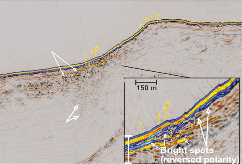
Review Article A Geophysical Review of the Seabed Methane Seepage Features and Their Relationship with Gas Hydrate Systems - Hindawi.com
4                                                                                                                     Geofluids

features. As a result, it is necessary to better understand the   alies transported from underneath by folding or faulting.
spatial relationship between seabed methane seepage and the       The results are dependent on several assumptions including
gas hydrate systems, as well as related fluid migration            velocities of seawater and sediments, as well as gas composi-
conduits.                                                         tion. Changes in these parameters would lead to different
    However, the gas hydrate occurrence is not always indi-       RGG values, which represent the uncertainties of this
cated by an obvious BSR in seismic data, and gas hydrates         modelling. With the numerical modelling, the GHSZ range
may exist without BSR such as in Site 994 of ODP Leg 164          can be predicted which can help characterize the spatial rela-
[10]. When it exists, the BSR often decreases as the seabed       tionship between gas hydrate systems and the seabed meth-
shallows until it intersects with the seabed, where it is known   ane seepage features, therefore evaluating the role of gas
as the landward limit of gas hydrate stability zone (LLGHSZ)      hydrate systems in forming seabed methane seepage.
representing the shallowest water depth of GHSZ. Due to
limited methane supply and the anaerobic oxidation of             3. Characterization of Seabed Methane
methane (AOM) at shallow depth, both BSR and LLGHSZ                  Seepage Manifestations
are rarely visible in the vicinity of the theoretical LLGHSZ
in seismic data in many gas hydrate occurrence areas [4,          Seabed methane seepage is often characterized by seabed
35, 48–50]. In areas without BSR development, it is difficult       manifestations such as methane flares, pockmarks, carbon-
to recognize the GHSZ which may hinder judging whether            ate crusts on mounds or pavements, coral reefs, mud volca-
the methane source for the seabed methane seepage is              noes, hydrate pingoes, and chemosynthetic biological
related with the gas hydrate systems or not. In these circum-     communities [1, 4, 12, 52, 53]. The size and density of these
stances, the BSR can be numerically modelled in MATLAB            seabed manifestations reflect the volume of methane trans-
software by assuming a proper gas composition and a rea-          ferred from geosphere to hydrosphere or even the atmo-
sonable salinity for the modelled gas hydrate systems             sphere, whose presence also indicates the existence of
(Figure 2). The temperature distribution is calculated by a       underlying hydrocarbon reservoirs or gas hydrate systems
two-dimensional steady-state heat conduction model, with          [1, 53]. The gas source of methane seepage at the seabed
related equation discretized in space using finite differences      can be from shallow biogenic gas and deep thermogenic
and solved directly using MATLAB’s MLDIVIDE function.             gas or from gas hydrate dissociation [25]. However, gas
The upper boundary condition is determined by fixing the           hydrate outcrops are often observed at the seabed methane
temperature at the seabed to the seawater temperature at          seepage sites regardless of their gas sources, which are
the depth of the local seabed surface (retrieved from the         mainly determined by the proper temperature and pressure
World Ocean Database; Figure 2). The lower boundary con-          conditions at the seabed. Therefore, we propose that the
dition is applied by fixing the geothermal gradient to a uni-      presence of gas hydrate outcrops does not indicate that the
form value at 5 km below the seabed. This boundary                gas source of seabed methane seepage is directly from the
geothermal gradient is therefore referred to as the regional      gas hydrate systems. In this section, the detailed characteris-
geothermal gradient (RGG). The depth of the seabed is cal-        tics of main seabed methane seepage features are introduced,
culated from the TWT time, which is converted to depth            including pockmarks and carbonates, deep-water corals, and
using a water velocity of 1.5 km s-1. A pressure profile is        mud volcanoes. Related fluid migration conduits are inter-
obtained by assuming a constant hydrostatic pressure gradi-       preted, as well as nearby gas hydrate systems. Based on a
ent of 10.09 MPa km-1. Then, the depth of the BSR can be          combined analysis of these factors, the specific gas source
determined using the hydrate stability curve which is suit-       of seabed methane seepage can be determined which help
able for the studied gas hydrate system.                          accurately evaluate the role of different gas sources in affect-
    For example, the gas hydrate stability curve for pure         ing the carbon cycling by seabed methane seepage.
methane with a salinity of 35 wt. % given by Moridis [51]
is used to predict the BSR locations in two seismic profiles       3.1. Pockmarks and Carbonates. Pockmarks are crater-like
from Niger Delta and Qiongdongnan Basin of South China            depressions developed in fine marine or lacustrine sediments
Sea (Figure 3). The depth of the BSR is determined by             in various geological environments, probably due to over-
hydrate stability conditions and can be calculated by numer-      pressure discharge of subsurface fluids at the seabed
ical modelling through assuming proper controlling param-         [54–56]. As the result of fluid migration through sediments
eters. Regional geothermal gradient (RGG) is considered as a      and expulsion at the seabed, pockmarks were often inter-
calibration parameter in this context, and an optimal fit          preted to overlie hydrocarbon reservoirs or gas hydrate sys-
between the modelled and observed BSR was obtained by             tems (including gas hydrates and underlying free gas zone)
adjusting the RGG value in the geothermal gradient range          which are the possible fluid sources [1, 53]. Limited data
of the study area. Results show that optimal fit between the       has been known about the process of fluid venting which
modelled and observed BSR can be obtained by setting a            formed and maintained the pockmarks, but several mecha-
RGG value of 4.2°C/hm for the seismic profile from Niger           nisms have been raised as drivers of fluid migration includ-
Delta and by setting a RGG value of 3.5°C/hm for the seis-        ing migration from overpressured hydrocarbon reservoirs
mic profile from Qiongdongnan Basin (Figure 3). For both           along vertical conduits like faults, fractures, and gas chim-
seismic profiles, the BSRs at the crest of the anticlines          neys, sediment compaction, overpressure dissipation via
(Figure 3(a)) or above the focused cluster of faults              focused vertical fluid migration conduits or salt/mud diapirs,
(Figure 3(b)) are vaulted, probably due to the thermal anom-      gas hydrate dissociation, and related methane seepage
Review Article A Geophysical Review of the Seabed Methane Seepage Features and Their Relationship with Gas Hydrate Systems - Hindawi.com
Geofluids                                                                                                                                              5

               0                                                             0

              500

             1000                                                          500
 Depth (m)

             1500

                                                              Depth (m)
                                                                          1000
             2000

                    30   31   32      33     34    35    36
                              Salinity (psu)

                                                                          1500

                                                                          2000

                                                                                 0                          10                         20      30
                                                                                                                     Temperature (degrees°C)
                              (a)                                                                                          (b)
                                                  22°N

                                                  20°N
                                                                                 Hainan

                                                  18°N

                                                  16°N
                                                                                                                       a
                                                                                                                 a   Se
                                                              Vietnam                                         in
                                                  14°N                                                      Ch
                                                                                                        h
                                                                                                     ut
                                                                                                   So
                                                  12°N
                                                          106°E           108°E 110°E 112°E 114°E 116°E
                                                                                     (c)

Figure 2: Data used in numerical modelling of the BSR. (a) Scatter plot of the sea water salinity with varying seabed depths in the northern
South China Sea. (b) Scatter plot of the sea water temperature with varying seabed depths in the northern South China Sea. (c) Location map
of the data points.

around the LLGHSZ. Pockmarks occur in both random and                                      fluid migration conduits since the gas source is directly from
nonrandom distribution patterns, probably controlled by                                    in situ hydrate dissociation.
both the distribution of subsurface fluid conduits and the                                      In global case studies, there are different kinds of pock-
overpressured fluid source [53]. However, at the LLGHSZ                                     marks. For example, giant pockmarks formed in the Faroe
where gas hydrate dissociation often occurs, pockmarks                                     Shetland Basin due to a sudden expulsion of a methane res-
may occur in linear patterns without obvious subsurface                                    ervoir which is deeper than the GHSZ, probably driven by
Review Article A Geophysical Review of the Seabed Methane Seepage Features and Their Relationship with Gas Hydrate Systems - Hindawi.com
6                                                                                                                            Geofluids

                                                                                         Pockmark

                3400
                                                                                              Observed BSR

                3600   Seabed

                3800                                                                                 Modelled BSR
     TWT (ms)

                4000
                                                 Fold                                                       Fold

                4200

                       Fault
                4400

                                                                                                    Fault
                4600

                        3 km                  Fault

                                                                   (a)

                                   Pockmark
                                                        Pockmark
                1500                                                      Pockmark            Seabed

                1600
                                                                                     Observed BSR
     TWT (ms)

                1700
                                                                              HAAs
                1800

                1900                                           Modelled BSR

                2000                                                                 Faults

                       3 km

                                                                   (b)

Figure 3: Numerical modelling results showing the observed BSR (yellow line) and the modelled BSR (blue line). (a) A seismic profile from
Niger Delta showing faults and seabed pockmark. (b) A seismic profile from Qiongdongnan Basin showing faults and seabed pockmarks.

natural reservoir overpressure [57]. The overpressure was                around the LLGHSZ. Gas hydrate dissociation due to differ-
interpreted to be mainly trigger by tectonic compression                 ential sediment loading and global warming was proposed to
because other causes are too gradual and modest, which                   be responsible for the formation of these pockmarks, which
opened the vertical conduits by exploiting the weakness in               caused pore fluid overpressure and vertical fluid migration
the seal. Figure 4 shows the relationship between pockmarks              [19]. Within the GHSZ scope, there are few pockmark
and gas hydrate systems in the U.S. Atlantic continental                 occurrence at the seabed compared to the huge amount of
margin, and there are two types of pockmarks considering                 pockmarks around the LLGHSZ. The fluid source for these
their relationship with the gas hydrate systems [18, 19].                pockmark formation could be from both gas hydrate sys-
The pockmarks much shallower than the LLGHSZ are                         tems and deeper hydrocarbon reservoirs, which can be
caused by the overpressure of the shallow gas reservoir, irrel-          deduced by the vertical distribution of fluid migration con-
evant to the gas hydrate systems (Figure 4(a)). In                       duits [58, 59]. As shown in Figure 4(c), these two pockmarks
Figure 4(b), more than 5000 pockmarks were observed in a                 were formed as a result of overpressure dissipation, and the
1100 km stretch along the strike of the U.S. Atlantic conti-             overpressure was probably caused by the continuous accu-
nental margin, and most of the pockmarks are located                     mulation of free gas below the base of gas hydrate stability
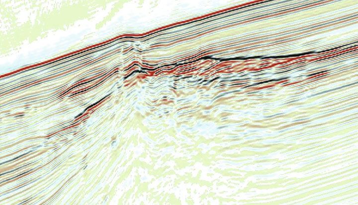
Review Article A Geophysical Review of the Seabed Methane Seepage Features and Their Relationship with Gas Hydrate Systems - Hindawi.com
Geofluids                                                                                                                                      7

               0
                                  Pockmark                                                                                          5 km
                                           s
             500

                                                                                                C
             1000   Zone of high chimney probability
  TWT (ms)

                                                                                                            Pockmark
                                                                                                                     s
             1500
                                                                                                            GHSZ

             2000
                                                                                                        Free Gas
                                                                   Zone of high chimney
             2500
                                                                   probability (Eocence and
                                                                   Cretaeous strata)

                                                                          (a)
                                                                           Seafloor
                                                                                                    Inactive Poc
                                                                                                                kmarks
                                                                         ~10 m
                                                                                                                                   300 m

                                                                                      Gas hydrate zone
                                                       Site 1073

                                                                                                                         Chimney
                         Base of
                         Pleistocene
                                                                                  Free gas
                                                                                             zone

                ~300 m
                                                                           ~100 m

                                           (b)                                                                 (c)

Figure 4: (a) Schematic diagram showing pockmarks, related gas chimneys, and nearby gas hydrate stability zone (modified from Brothers
et al. [19]). Pockmarks in the updip of the GHSZ are interpreted to be due to the overpressure of the shallow gas reservoir, which is irrelevant
to the gas hydrate system. Additionally, the pockmarks within the GHSZ scope were caused by the overpressure of the free gas zone which
triggered the formation of gas chimneys and pockmarks. (b) 3D view of seismic data showing the landward limit of GHSZ and nearby
numerous pockmarks which were the result of gas hydrate dissociation due to the seaward retreat of the GHSZ during global warming
or sea level change (modified from Brothers et al. [19]). (c) Seismic data showing the inactive pockmarks, gas chimneys, and the free gas
zone below the base of the gas hydrate stability zone (modified from Plaza-Faverola et al. [60]).

zone [60]. The pockmarks became inactive shortly after                          with sediments and bacterial mats first and complete block-
transient initial expulsion, which may be reactivated when                      age by carbonate precipitation which builds up a carbonate
the free gas accumulates again and generates required over-                     crust [1, 67]. Additionally, authigenic carbonates are often
pressure [57, 60]. Besides the present pockmarks, there are                     regarded as associated with the gas hydrate systems [68,
also paleopockmarks which are buried pockmarks indicating                       69]. A case study from the southern summit of the Hydrate
the fluid escape features in the geological past [61]                            Ridge of the Cascadia margin shows that the carbonate for-
(Figures 5(c) and 5(d)).                                                        mation may be related to the dynamic formation and disso-
    Authigenic carbonates often extensively coexist with                        ciation of gas hydrates due to its fragile stability [41].
methane seepage features in different geological settings,                       However, the relationship of gas hydrates and carbonates is
representing the removal of methane and inhibiting its emis-                    in substance related to the fluid source, and it was proposed
sion to the sea water or even the atmosphere [62–64]. It is                     that prolific methane seepage will lead to increased AOM
commonly believed that the biological process of anaerobic                      efficiency [63]. For example, researchers found that 10 m
oxidation of methane (AOM) couple to sulphate reduction                         high ridges of methane-derived authigenic carbonate rocks
(SR) is mediated by anaerobic methanotrophs and                                 developed within a large pockmark in mid-Norway [70]
sulphate-reducing bacteria in anaerobic environments, with                      (Figures 5(a) and 5(b)). The amount of authigenic carbon-
authigenic carbonates being the main by-product of the                          ates is comprehensively determined by the methane supply
AOM-SR process [63–66]. According to previous studies,                          and the rate of AOM and the duration time [71]. Not all
the formation of carbonates will eventually seal the seeping                    pockmarks are accompanied by authigenic carbonates. For
feature, which is characterized by partial seepage clogged                      example, in the northern Carnarvon basin offshore
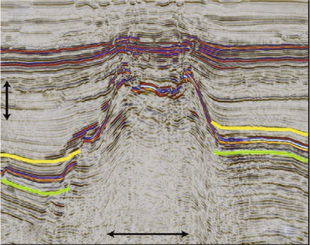
Review Article A Geophysical Review of the Seabed Methane Seepage Features and Their Relationship with Gas Hydrate Systems - Hindawi.com
8                                                                                                                               Geofluids

                                                                                                                       N

                                                                                             o        ⁎

                                                                                                                    100 m

                                            (a)                                                     (b)

                                   NNW-SSE Faults                                         Paleo-pockmarks
                                                                              West                                  East

                                                                              200 ms

                                                        Paleo-Pockmarks
                                                                               1 km                         Pipes
                                     1 km
                                                                          N

                                                  (c)                                         (d)

                                Carbonate
                                reef mounds

                                                                              200 ms

                                                                          N                 2 km               East
                                                                              West
                                                         2.5 km

                                                  (e)                                         (f)

Figure 5: (a) Photo of carbonates at the seabed observed by ROV located within a large pockmark as shown in (b) (modified from Hovland
et al. [70]). (b) A large pockmark with carbonates developed within it in mid-Norway (modified from Hovland et al. [70]). (c) Plan view map
showing the linear distribution of paleopockmarks in Exmouth Plateau, Northern Carnarvon Basin (modified from Velayatham et al. [61]).
(d) A seismic profile showing the paleopockmarks in Exmouth Plateau, Northern Carnarvon Basin (modified from Velayatham et al. [61]).
(e) Plan view map showing the carbonates in Exmouth Plateau, Northern Carnarvon Basin (modified from Velayatham et al. [61]). (f)
Seismic profile showing the positive relief of carbonates in Exmouth Plateau, Northern Carnarvon Basin (modified from Velayatham
et al. [61]).

northwest Australia, the pockmarks in the east are not                        the gas hydrate system. Compilation shows that 62.2% pock-
accompanied by carbonate rocks, while the pockmarks in                        marks are accompanied by authigenic carbonates, and the
the west are accompanied by carbonate rocks [61]                              preponderance of pockmarks coexists with the gas hydrate
(Figures 5(c)–5(f)).                                                          systems or around the LLGHSZ. According to previous
    In Table 1, we supplement the pockmark compilation of                     studies, the pockmark density and total number of pock-
Panieri et al. [53] by referring to more published global case                marks are the largest around the LLGHSZ which has been
studies, displaying information on water depth, pockmark                      observed in Arctic continental shelves [72, 73], US Atlantic
formation mechanism including relevant fluid pathways                          margin [18–20], and the West Spitsbergen continental mar-
and gas source, nearby carbonates, and relationship with                      gin [21].
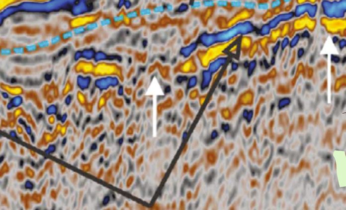
Review Article A Geophysical Review of the Seabed Methane Seepage Features and Their Relationship with Gas Hydrate Systems - Hindawi.com
Geofluids                                                                                                                          9

Table 1: Compilation of pockmark and carbonate locations around the world showing formation mechanisms and relationship with the gas
hydrate systems (modified from Panieri et al. [53]).

                                                                                                      Relationship with
                            Water
Pockmark location                               Formation mechanisms                   Carbonates      the gas hydrate References
                            depth
                                                                                                            system
Arctic Ocean (Vestnesa           Fluid pathways: faults, chimneys, and fractures  Carbonates of   Deeper than the    [60, 74,
                            1200 m
Ridge)                           Gas source: deep reservoir and shallow free gas various shapes        LLGHSZ           75]
                                     Fluid pathways: tectonic controls (faults)
Arctic Ocean (Spitsbergen   110-                                                                   Shallower than
                                 Gas source: thermogenic gas from the organic-       No report                         [76]
fjords)                    130 m                                                                      the GHSZ
                                                     rich shales
                                      Fluid pathways: gas pressure and faults
                            200-                                                    Authigenic     Gas hydrates at
Barents Sea                            Gas source: thermogenic gas, hydrate                                         [77–80]
                          1270 m                                                    carbonates     different depths
                                                    dissociation
                             <          Fluid pathways: faults and fractures                       Shallower than
Bering Sea (Alaska)                                                                  No report                         [81]
                           200 m    Gas source: biogenic and thermogenic gas                          the GHSZ
Norwegian Sea (Troll                 Fluid pathways: gas hydrate dissociation       Authigenic     Shallower than
                           300 m                                                                                       [82]
region)                                       Gas source: gas hydrate               carbonates        the GHSZ
Norwegian Sea                     Fluid pathways: overpressure, chimneys, and                      Shallower than
                            300-
(continental shelf and                                fractures                  Carbonate ridges     the GHSZ         [83]
                           800 m
slope)                                 Gas source: gas reservoir and free gas                     Around LLGHSZ
                                                                                                  Around LLGHSZ
Norwegian Sea (Nyegga       500-       Fluid pathways: chimneys and faults        Carbonates of
                                                                                                  Deeper than the      [84]
region)                   1500 m       Gas source: gas reservoir and free gas     various shapes
                                                                                                       LLGHSZ
                                                                                                  Around LLGHSZ
                            400-     Fluid pathways: gas hydrate dissociation
NE Atlantic margin                                                                   No report    Deeper than the      [85]
                          1500 m              Gas source: gas hydrate
                                                                                                       LLGHSZ
Strait between Norway and 100-         Fluid pathways: clay diapir and faults       Carbonate      Shallower than
                                                                                                                       [86]
Denmark (Skagerrak)       200 m     Gas source: biogenic and thermogenic gas         cemented         the GHSZ
                                  Fluid pathways: fault formation inside iceberg    Authigenic
                            130-                                                                   Shallower than
Canada (Pacific margin)                             ploughmarks                      carbonates,                     [87, 88]
                          250 m                                                                       the GHSZ
                                           Gas source: hydrocarbon gas           carbonate ridges
                                    Fluid pathways: degradation of subseabed
North Sea, UK sector        100-                                                                   Shallower than
                                                   permafrost ice                    No report                         [89]
(Witch Ground Basin)      150 m                                                                       the GHSZ
                                    Gas source: biogenic and thermogenic gas
Atlantic Ocean (Belfast                      Fluid pathways: structure                             Shallower than
                           30 m                                                      No report                         [90]
Bay, Maine)                      Gas source: biogenic natural gas and pore water                      the GHSZ
                                                                                      Biogenic
Pacific Ocean (Big Sur,      900-             Fluid pathways: no report                            Deeper than the
                                                                                     carbonate                         [91]
California)               1200 m                Gas source: free gas                                   LLGHSZ
                                                                                     fragments
                                                                                                   Shallower than
                            100-               Fluid pathways: fault                Carbonate
Gulf of Mexico                                                                                        the GHSZ         [92]
                           500 m            Gas source: thermogenic gas               buildups
                                                                                                  Around LLGHSZ
                                     Fluid pathways: faults and salt diapirism                    Around LLGHSZ
Atlantic Ocean (Santos      400-
                                     Gas source: salt diapirs and hydrocarbon        No report    Deeper than the   [52, 93]
Basin)                     900 m
                                                      province                                         LLGHSZ
                                   Fluid pathways: faults, overpressure, hydrate
                           1100-                                                 Carbonate rock Deeper than the
SW Africa (Niger Delta)                             dissociation                                                       [94]
                          1250 m                                                        crust          LLGHSZ
                                          Gas source: hydrate dissociation
SW Africa (Congo deep-           Fluid pathways: faults, chimneys, and fractures                  Deeper than the
                          3160 m                                                 Carbonate crusts                      [95]
sea channel)                                   Gas source: no report                                   LLGHSZ
                                     Fluid pathways: fault zones, salt diapirs,
SW Africa (Northern                                                               Carbonates of   Deeper than the
                          3100 m                  polygonal faults                                                 [96, 97]
Congo Fan)                                                                        various shapes       LLGHSZ
                                              Gas source: biogenic gas
South China Sea (N          600-      Fluid pathways: listric faults, chimneys      Carbonate     Deeper than the
                                                                                                                       [98]
Zhongjiannan Basin)       1400 m        Gas source: hydrocarbon-rich fluids            cements          LLGHSZ
South China Sea (Xisha                    Fluid pathways: faults, chimney                         Deeper than the
                           700 m                                                     No report                         [99]
Uplift)                                      Gas source: deep reservoir                                LLGHSZ
Review Article A Geophysical Review of the Seabed Methane Seepage Features and Their Relationship with Gas Hydrate Systems - Hindawi.com
10                                                                                                                             Geofluids

                                                          Table 1: Continued.

                                                                                                             Relationship with
                             Water
Pockmark location                                 Formation mechanisms                      Carbonates        the gas hydrate References
                             depth
                                                                                                                   system
                              300-      Fluid pathways: faults, chimney, and diapir         Authigenic        Shallower than
E Atlantic (Gulf of Cadiz)                                                                                                      [100]
                             400 m      Gas source: biogenic and thermogenic gas            carbonates          the GHSZ
Central Mediterranean
                              110-                 Fluid pathways: faults                   Authigenic        Shallower than
(Zannone Giant                                                                                                                  [101]
                             130 m               Fluid pathways: no report                  carbonates          the GHSZ
Pockmark)
                                       Fluid pathways: episodic dissociation of gas-
W Mediterranean Sea                                                                                          Around LLGHSZ
                              500-     hydrate-rich sediments, tectonic and climate/
(TASYO field, Gulf of                                                                      Carbonate crusts   Deeper than the    [102]
                             2000 m                oceanographic factors
Cadiz)                                                                                                          LLGHSZ
                                                 Gas source: petrogenic gas
SW Mediterranean Sea          200-       Fluid pathways: faults, sediment lithology                           Shallower than
                                                                                             No report                          [103]
(Gulf of Cadiz)              400 m       Gas source: biogenic and thermogenic gas                               the GHSZ
E Mediterranean Sea           20-            Fluid pathways: faults, earthquake                               Shallower than
                                                                                             No report                          [104]
(Patras Gulf, Greece)        80 m                  Gas source: no report                                        the GHSZ
E Mediterranean Sea                    Fluid pathways: gas venting and groundwater
                              20-                                                                             Shallower than
(Patras and Corinth gulfs,                                 seepage                           No report                          [105]
                             40 m                                                                               the GHSZ
Greece)                                       Gas source: underground water
E Mediterranean Sea                                Fluid pathways: faults                                    Shallower than
                             70 m                                                         Buried carbonate                      [106]
(Iskenderun Bay)                                   Gas source: no report                                        the GHSZ
NW Black Sea (Dnepr                              Fluid pathways: no report                   Carbonate       Shallower than
                             90 m                                                                                               [107]
paleodelta)                                         Gas source: free gas                     cemented           the GHSZ
                              100-        Fluid pathways: local subsidence, faults                             Hydrates at
E Black Sea                                                                                  No report                          [108]
                             2000 m               Gas source: shallow gas                                    different depths
                                        Fluid pathways: deep-seated faults, collapse
                              20-                                                                             Shallower than
Western Indian margin                     structures, dissociation of gas hydrates           No report                          [109]
                             260 m                                                                              the GHSZ
                                                Gas source: thermogenic gas
                                                                                             Crusts of
NW Shelf of Australia
                              50-     Fluid pathways: preexisting fractures and dykes        cemented         Shallower than
(Yampi Shelf and Timor                                                                                                          [110]
                             100 m                Gas source: no report                      bioclastic         the GHSZ
Sea region)
                                                                                              material
Northwest Australia           20-            Fluid pathways: faults, overpressure          Carbonate reef     Shallower than
                                                                                                                                 [61]
(Exmouth Plateau)            95 m                    Gas source: no report                    mounds            the GHSZ
                                      Fluid pathways: faults and diapir, coarse-grained
South China Sea               10-                                                                             Shallower than
                                             sediments, unconformity, fractures              No report                          [111]
(Yinggehai Basin)            50 m                                                                               the GHSZ
                                         Gas source: hydrocarbons in the sediments
South China Sea (SW of        600-         Fluid pathways: gas chimney and faults           Authigenic       Deeper than the
                                                                                                                                [112]
Qiongdongnan Basin)          1600 m         Gas source: free gas, thermogenic gas           carbonates          LLGHSZ
Western margin of the                  Fluid pathways: extensional fault, the thermal
                              900-                                                         Carbonate reef    Deeper than the
South China Sea                              subsidence fault, and uplifting fault                                              [113]
                             1100 m                                                           mounds            LLGHSZ
(Zhongjiannan Basin)                         Gas source: deep reservoir, free gas
South China Sea (northern     1600-   The fractures in the seepage pathways provided        Authigenic       Deeper than the
                                                                                                                                [114]
Qiongdongnan Basin)          1800 m          direct evidence of vertical fluid flow           carbonates          LLGHSZ
Northeast Atlantic            900-           Fluid pathways: faults, overpressure                            Deeper than the
                                                                                             No report                          [115]
(northern Rockall Trough)    1000 m                 Gas source: pore water                                      LLGHSZ

3.2. Deep-Water Corals. Deep-water corals, also known as               0 to 13.6°C [118]. Till now, deep-water corals have been dis-
cold-water corals, were first described in the 18th century             covered at many locations all over the world (Figure 1(b);
[116], but until the late 20th century were the deep-water             Table 2), such as off mid-Norway [118], North Sea [119],
corals generally delineated with the development of sub-               South China Sea [120], Mediterranean Sea [121], Atlantic
mersibles [117]. They often live without light in relatively           Ocean [122, 123], and offshore Mauritania [124]. Most stud-
nutrient-rich seawater and are independent of symbiotic                ies of deep-water corals focused on their biology and role in
algae. Deep-water corals commonly occur at water depth                 global climate change, while limited has been done about
ranging from 39 to over 2000 m, which cover the latitude               their formation mechanisms. Hovland and Thomsen [118]
ranging from 70°N to 60°S, with temperature ranging from               proposed that the deep-water corals in off mid-Norway are
Geofluids                                                                                                                              11

Table 2: Compilation of deep-water coral locations around the world showing information on water depth, size, coral types, relationship
with the gas hydrate system, and related fluid seepage.

                                                                                      Relationship
Deep-water coral       Water                                                                              Related fluid
                                          Size                      Types               with gas                            References
location               depth                                                                                seepage
                                                                                     hydrate system
Norway (northern,       39-       Height: 45 m, width:                               Shallower than
                                                                  L. pertusa                           Hydrocarbon seeps      [140]
mid, southwest)        400 m            >100 m                                         the GHSZ
                                                                                                            Gas seeps
                                                                                                           Authigenic
New Zealand             756-                                   Desmophyllum,          Deeper than
                                      Coral ridge                                                          carbonates      [141, 142]
(Hikurangi Margin)     1120 m                                   Caryophyllia          the LLGHSZ
                                                                                                         Chemosynthetic
                                                                                                              fauna
                                                                                                        “Invasions” of the
Gulf of Cádiz
                        800-                                     L. pertusa           Deeper than            warmer
(Guadalquivir                          No report                                                                             [143]
                       1100 m                                    M. oculata           the LLGHSZ          Mediterranean
Diapiric Ridge)
                                                                                                              fauna
                                                                                                       Active hydrocarbon
                                 Height and width: 1.5-
Gulf of Mexico (De      434-                                                            Around               seepage
                                  2 m, length: 3-4 m,             L. pertusa                                                 [144]
Soto Slope)            530 m                                                            LLGHSZ          Carbonate knolls
                                   diameter: >1.5 m
                                                                                                            and ridges
                                                                                     Shallower than
                        39-         Height: 2-33 m,                                     the GHSZ
Norwegian coast                                                   L. pertusa                             Iceberg plough       [145]
                       550 m      diameter: 50-500 m                                     Around
                                                                                         LLGHSZ
Canada (Jordan          154-                                                         Gas hydrates at     Hydrodynamic
                                       No report                  L. pertusa                                                  [146]
basin)                 1400 m                                                        different depths        regime
                                   Height: 100-140 m,
NE Atlantic             798-                                     L. pertusa           Deeper than
                                  width: 650 m, length:                                                    Carbonates         [147]
(Porcupine Seabight)   942 m                                     M. oculata           the LLGHSZ
                                         1.3 km
Irish margin (Rockall 100-                                                          Gas hydrates at
                                       No report                  No report                                 Hiatuses          [123]
Bank)                 1000 m                                                        different depths
SE U.S. (Blake         640-                                                           Deeper than
                                     Height: 146 m                L. pertusa                               No report          [148]
Plateau)              869 m                                                          the LLGHSZ
SE U.S. (Straits of    490-                                                             Around           Strong bottom
                                    Height: 15-23 m              Octocorallia                                                 [148]
Florida)              550 m                                                             LLGHSZ              currents
SE U.S. (eastern Gulf                                                                 Deeper than
                      780 m          Height: 140 m                No report                                No report          [148]
of Mexico)                                                                           the LLGHSZ
                                                                                    Shallower than
Gulf of Mexico
                        315-                                                           the GHSZ
(upper continental                     No report                  L. pertusa                               Gas seeps          [149]
                       535 m                                                            Around
slope)
                                                                                        LLGHSZ
Uruguayan (outer      167-                                                          Shallower than
                                     Height: ~35 m                No report                                Gas seeps          [122]
shelf and slope)     326 m                                                             the GHSZ
                      982-                                Corallium, Paragorgia, D. Deeper than
SW Australia                           No report                                                           No report          [150]
                    2395 m                                         dianthus          the LLGHSZ
New Zealand (region 200-                                   Oculina, M. oculata, O. Gas hydrates at       Strong bottom
                                       No report                                                                              [151]
seamounts)          2850 m                                          virgosa         different depths         currents
                                                             Anthomastus spp.
Bay of Biscay           880-                                      L. pertusa          Deeper than        Strong bottom
                                       No report                                                                            [152, 153]
(Whittard Canyon)      3300 m                                     Octocorals         the LLGHSZ             currents
                                                                Primnoa spp.
                     800-                                                             Deeper than        Strong bottom
Mid-Atlantic Ridge                     No report                  Octocorals                                                  [154]
                    2400 m                                                           the LLGHSZ             currents
Central              100-                                                           Gas hydrates at
                                     Height:
12                                                                                                                                 Geofluids

                                                             Table 2: Continued.

                                                                                           Relationship
Deep-water coral       Water                                                                                   Related fluid
                                          Size                         Types                 with gas                              References
location               depth                                                                                     seepage
                                                                                          hydrate system
                                                               L. pertusa, M. oculata,
                                                               Solenosmilia variabilis,
                                                                   Desmophyllum
Off southwest Ireland 200-        Height: 200 m, width:                                    Gas hydrates at
                                                                   Coral mound                               Bottom currents         [156]
(Porcupine Basin)    2000 m       1 km, length: 5 km                                      different depths
                                                                                              Around
Southern Rockall        500-     Height: 350 m, width:                                        LLGHSZ
                                                                   Coral mound                               Bottom currents         [157]
Trough                 1200 m            2 km                                               Deeper than
                                                                                           the LLGHSZ
                                                                                          Shallower than
Agdenes morainic        150-                                                                 the GHSZ
                                     Width: 100 m                    L. pertusa                               Gas chimneys           [158]
ridge                  500 m                                                                  Around
                                                                                              LLGHSZ
                        233-     Height: 45 km, length:                                   Shallower than
Sula Ridge                                                           L. pertusa                               Gas chimneys           [159]
                       330 m             13 km                                               the GHSZ
Off mid-Norway (east                                                                       Shallower than
                       280 m           No report                     L. pertusa                                 Gas seeps            [158]
Draugen field)                                                                                the GHSZ
Norwegian                       The largest: height: 15 m,
                        300-                                                              Shallower than
Concession Block                 length: 700 m, width:               L. pertusa                               Gas chimneys           [158]
                       330 m                                                                the GHSZ
(island Træna)                           150 m
Off mid-Norway
                        310-       The largest: height:                                   Shallower than
(Kristin hydrocarbon                                                 No report                                  No report             [70]
                       385 m       3.5 m, length: 90 m                                      the GHSZ
field)
Between Norway and
                                                                                          Shallower than
UK (Langeled           280 m           No report                     L. pertusa                                 No report            [158]
                                                                                            the GHSZ
pipeline)
                        200- Height: 20 m, width: 150-                                    Shallower than
Vestera° lsgrunnen                                                   No report                               Bottom currents         [158]
                       270 m          200 m                                                 the GHSZ
                                                                                          Shallower than    Gas seeps, bacterial
West Skogsøy           200 m           No report                  Floholman reefs                                                    [158]
                                                                                            the GHSZ               mats
                        300-      Width: 3 km, length:                                    Shallower than        Gas seeps,
Storegga slope                                                       L. pertusa                                                      [158]
                       400 m            35 km                                               the GHSZ            pockmarks
Swedish and
                        75-      Width: 200 m, length:                                    Shallower than
Norwegian (eastern                                                   L. pertusa                                 No report            [158]
                       160 m            1.2 km                                              the GHSZ
coast of Kattegat)
                        275-                                         L. pertusa           Gas hydrates at
Bill Bailey bank                      Height: 30 m                                                             No report             [158]
                       1020 m                                        M. oculata           different depths
                                                                                              Around
NW Porcupine Bank  500-           The largest: height:                                       LLGHSZ
                                                                     L. pertusa                                No report             [158]
(Rockall Bank)    1200 m          100 m, length: 5 km                                       Deeper than
                                                                                           the LLGHSZ
Northernmost            900-                                                                Deeper than
                              Height: 5 m, width: 75 m               L. pertusa                                Gas seeps             [115]
Rockall Trough         1060 m                                                              the LLGHSZ
Campos Basin off         570-                                                                Deeper than Hydrocarbons from
                               Covers about 600 km2                  L. pertusa                                                       [52]
Brazil                 850 m                                                               the LLGHSZ          sediments
                        400-    Height: 60 m, width:                                          Around      Salt diapirs or salt
Gulf of Mexico                                                       L. pertusa                                                      [158]
                       600 m           1.2 km                                                LLGHSZ              stocks
                               Height: 160 m, width:                                        Deeper than       Gas seeps,
Blake Ridge            700 m                                         No report                                                       [158]
                                       800 m                                               the LLGHSZ          pockmark
Canada (east            1900-  Height: 200 m, width:                                        Deeper than
                                                                     No report                                 No report             [158]
Newfoundland)          2100 m           2 km                                               the LLGHSZ
South of the Charlie                                                                        Deeper than
                       1340 m      Diameter:
Geofluids                                                                                                                        13

                                                           Table 2: Continued.

                                                                                     Relationship
Deep-water coral       Water                                                                            Related fluid
                                         Size                        Types             with gas                         References
location               depth                                                                              seepage
                                                                                    hydrate system
                               Height: 30 m, width: 200-                             Shallower than Gas seeps, chimney,
Lower Congo Basin      400 m                                       No report                                            [158, 160]
                                        400 m                                          the GHSZ          salt diapir

related to hydrocarbon seeps, on which the bacteria and               systems and offers insights into diagenetic processes like
other microorganisms thrived and provided the deep-water              mineral dissolution and transformation, degradation of
corals with substantial food source. Deep-water corals were           organic material, and high pressure-temperature reactions
observed at the edge of pockmarks in Santos Basin with coral          [129–131]. The geometry and size of the mud volcanoes
rubble filling the surrounding sediments of the pockmarks,             are variable in different areas, often circular or subcircular
and it was proposed that the pockmark-related seabed                  in plane view. The height may range from several meters
hydrocarbon seepage may have fertilized the water by                  to hundreds of meters due to the emission scale, which is
increasing the concentration of nutrients which was favor-            mainly controlled by tectonic activity, rapid sediment load-
able for sustaining the corals [52]. Strong currents and low          ing, the presence of thick fine-grained sediments, and
sediment supply are also regarded as favorable conditions             enriched hydrocarbon accumulation [55, 132]. It was pro-
for the deep-water coral and associated benthic fauna.                posed that compression and rapid sedimentation are mainly
     Recent studies show that the formation of deep-water             responsible for the initiation and maintenance of mud volca-
corals is controlled by two major factors, one is suitable hard       noes, while weak argillaceous sediments under compression
substratum for coral colonization such as authigenic carbon-          are prone to experience mineral alteration and dehydration
ates and the other one is nutrient supply provided by                 processes, therefore causing brittle deformation such as
dynamic bottom current, seabed methane seepage, or gas                faulting [130]. Additionally, the preexistence of fault zones
hydrate systems [120, 125]. As a result, methane seepage fea-         may also act as favorable condition for the formation of
tures at the seabed often sustain a certain density of benthic        mud volcanoes [133]. Different from mud volcano, there is
life which is comparatively flourished compared to sur-                another similar feature called mud diapir which has risen
rounding areas [53, 126]. In seabed methane seepage areas,            from the deep sediments into shallower sediments [129]
the process of methane anaerobic oxidation at the subsurface          (Figure 7). When it reaches and pierces the seabed, mud vol-
forms authigenic carbonates, and released methane feeds the           cano will occur.
microorganisms which can act as food for the deep-water                   Many mud volcanoes in marine environments are asso-
corals, both favorable for the formation of deep-water corals         ciated with gas hydrate systems [129] (Figure 7). The pres-
(Figure 6(a)). Additionally, gas hydrate systems may help             ence of mud volcanoes is capable of changing the stability
fertilize the deep-water corals as well [120, 127]. A case study      conditions of gas hydrates and causing an upvaulted BSR,
from Porcupine Basin shows that methane released from gas             and the fluid migration associated with the mud volcanoes
hydrate dissociation, which is glacially controlled as a result       can supply methane for the formation of gas hydrates and
of global warming, may have played a big role in the forma-           underlying free gas zones [134, 135]. Additionally, gas
tion of deep-water coral reefs [127].                                 hydrate dissociation in response to sea level change, global
     Table 2 is the compilation of published data on deep-            warming, or local elevated heat flow may lead to the over-
water corals showing information on water depth, coral size,          pressure of the pore fluid and deformation of the sedimen-
relationship with gas hydrate system, and related fluid seep-          tary overburden, which eventually cause the expulsion of
age. Results show that most of the deep-water corals occur at         mud volcanoes [136, 137]. In these processes, fluid migra-
a depth of 200-1000 m, and their locations rely largely on            tion plays a key role in both gas hydrate formation and
hard substratum. According to the case studies in Table 2,            mud volcano formation.
42.5% of the deep-water corals are related to obvious fluid                In addition to these seabed methane seepage manifes-
seepage features and 70% of the deep-water corals are                 tations we introduced above, gas hydrate pingoes are also
located within the GHSZ scope and nearby LLGHSZ area.                 commonly observed at seabed methane seepage sites
Generally, case studies of the pockmarks, authigenic carbon-          [138, 139]. Gas hydrate pingoes, also known as gas
ates, and deep-water corals from all over the world indicate a        hydrate mounds, are the result of gas hydrate growth at
genetic link, with seabed methane seepage playing a key role          the very shallow subsurface sediments. Adequate gas sup-
in the formation of carbonates and deep-water corals.                 ply along faults, gas chimneys, and other fluid migration
                                                                      conduits will maintain the continuous formation of gas
3.3. Mud Volcanoes. Compared to other seabed methane                  hydrates, triggering the overlying sediments to swell and
seepage manifestations, submarine mud volcanoes are rela-             therefore causing gas hydrate pingoes. Generally, the for-
tively anonymous, mysterious, and seldomly discussed,                 mation of gas hydrate pingoes also depends on fluid
which are topographically expressed seabed edifice due to              migration which represents the plumbing system connect-
mud and fluid eruption [129]. The presence of mud volca-               ing the deep hydrocarbon fluids and shallower gas
noes often indicates deep petroleum assets or gas hydrate             hydrate reservoirs.
14                                                                                                                               Geofluids

                                                 Sea-level

                                                                     Coral reef

                                                                      Carbonates

                     ed
                 Seab                                        AOM

                        High methane flux

                                                             Gas hydrate
                                                             dissocation

                                                    (a)                                                       (b)

                                                   (c)                                             (d)

                                           (e)                                                     (f)

Figure 6: (a) Schematic diagram showing the formation mechanism of deep-water corals at a seabed methane seepage site. Authigenic
carbonates were formed by anaerobic oxidation methane (AOM) which provided hard substratum for corals (modified from Deng et al.
[120]). (b, c) Fragments of large sediments with white arrows indicating deep-water corals and red arrows indicating authigenic
carbonates. (d) Large carbonate rocks at seabed methane seepage site in northern South China Sea (modified from Feng and Chen
[128]). (e, f) Large carbonates and mussels suggesting that methane seepage in this area is sustainable (modified from Feng and Chen [128]).

4. Relevant Fluid Migration Conduits                                          may have reactivated preexisting fractures or have triggered
                                                                              new fractures, therefore facilitating fluid migration [3, 12].
The detailed characterization of the seabed methane seepage                   The gas source of fluid migration could be from overpres-
features shows that seabed methane seepage is often related                   sured hydrocarbon reservoirs or gas hydrate systems, which
to subsurface focused fluid migration conduits such as faults                  can be deduced from the vertical extension of the fluid
(Figure 3), gas chimneys (Figures 4, 5, and 8), unconfor-                     migration conduits. A seismic profile from Niger Delta
mities (Figure 9), mud volcanoes or diapirs (Figure 7), and                   shows that the gas chimney extends deeply into the deep
permeable sandstone layers. The stress change associated                      stratum, and we propose that the gas source for the seabed
with factors like tectonic events or rapid sediment loading                   methane seepage is probably from the deep hydrocarbon
Geofluids                                                                                                                          15

                                                 Pockmark

                                    d
                               Seabe

                                                 R
                                               BS
                                                                                FGZ
                                                      Faults

                                                                                               200 ms
                                        FGZ
                                                      Mud diapir

                                                                                                        1000 m

Figure 7: A seismic profile from offshore Mauritania area showing a pockmark above a mud diapir structure. The diapir structure and the
overlying related faults provide an advantageous migration channel for the overpressured fluids, which formed pockmarks at the seabed.
FGZ: free gas zone which is underlying the base of GHSZ.

                   2500                                                                                  Seabed methane seepage

                               Seabed
                                                               BSR

                   3000
        TWT (ms)

                   3500                                              Fluid migration pathway

                                        2 km

Figure 8: A seismic profile from Niger Delta, showing the seabed methane seepage feature and related underlying gas chimney. The gas
chimney acted as fluid migration conduit, transporting the deeper fluids (free gas, water, etc.) upward through the GHSZ to the seabed.

reservoir, rather than the shallower gas hydrate systems               ing from the seabed of the West Spitsbergen continental
(Figure 8). However, another seismic profile from Niger                 margin, and it was proposed that the gas source is from
Delta shows that the unconformity and faults may act as                hydrate dissociation with released methane migrated along
fluid conduits which have transported methane from the                  the base of GHSZ updip to the seabed [21].
free gas zone (FGZ) underlying the BSR or from gas reser-
voirs at the deep laterally to the updip, eventually forming           5. Discussions
seabed methane seepage at the seabed (Figure 9). Besides,
the base of GHSZ, as well as permeable sandstone layers,               On the basis of above characterization of the seabed meth-
can also act as fluid migration conduits which play roles in            ane seepage features and related fluid migration conduits,
forming the seabed methane seepage features by supplying               we divide the seabed methane seepage features into three
fluid source (Figure 4(b)). According to Westbrook et al.,              types according to its spatial relationship with the landward
hundreds of gas bubble plumes have been observed emanat-               limit of gas hydrate stability zone (LLGHSZ), deeper than
16                                                                                                                                        Geofluids

                                                               Seabed methane seepage

                                                                                                                           Seabed

                3000

                                                                                        BSR
     TWT (ms)

                       Fluid migration pathway

                3500

                                                                                                                    2 km
                                                                      Faults

Figure 9: A seismic profile from Niger Delta, showing the unconformity surface and faults which acted as fluid migration conduits. The free
gas underlying below the BSR migrated along the unconformity surface or fault to the seabed, forming methane seepage features.

                                                 Table 3: Relationship of GHSZ and seabed methane seepage.

Spatial relationship of
seabed methane seepage                    Related fluid migration pathways                              Source of methane                         Code
and the GHSZ
                                                                                    Methane source is irrelevant to the gas hydrate system
                                     Fault/gas chimney/diapirism/mud volcano/                                                                    A1
Deeper than LLGHSZ                                                                             and is from deeper gas reservoirs
                                     unconformity surface/permeable sandstone
A                                                                                   Methane source is from the gas hydrate system, like gas
                                                   layer/pockmark                                                                                A2
                                                                                      hydrate decomposition or underlying free gas zone
                                                                                    Methane source is independent of the hydrate system,
                                                                                     transported vertically along fluid migration conduits        B1
                                      The fluid migration conduits may be not              such as faults or gas chimney to the seabed
Around LLGHSZ
                                     obvious, and small-scale vertical faults/gas
B                                                                                   Methane source is from the gas hydrate decomposition,
                                          chimneys/pockmarks may exist
                                                                                    or methane was transported along the base of hydrate         B2
                                                                                             stability zone laterally to the seabed
                                     Fault/gas chimney/diapirism/mud volcano/       Methane seepage sites are out of the gas hydrate stability
Shallower than LLGHSZ
                                     unconformity surface/permeable sandstone        zone, and methane source is independent of the gas          C1
C
                                                   layer/pockmark                                        hydrate system

the LLGHSZ (A), around the LLGHSZ (B), and shallower                             A2, B1, B2, and C1 (Table 3), which will be explained
than LLGHSZ (C). In plane view, the LLGHSZ is a linear                           in the following sections.
feature in theory, but it often exists as a narrow zone due
to the dynamic shift of the LLGHSZ in response to geo-                           5.1. Deeper Than LLGHSZ (A). Seabed methane seepage dee-
logical events such as glacial unloading, sea level change,                      per than LLGHSZ is defined as type A in this paper, which is
and global warming [12]. These three types of seabed                             located in the range of GHSZ, but deeper than the landward
methane seepage can be further divided into five subtypes                         boundary of the gas hydrate stability zone (Figures 3, 4(c), 7,
based on the gas source of seabed methane seepage, A1,                           8, and 9). Considering the gas source, type A of seabed
Geofluids                                                                                                                                                                                                                                                                                                                                                               17

                                         (a)                                                                                                                                                                                                              (b)
                                                                                                                                                                                                                            Seafloor

                                                           1490

                                               TWT (ms)
                                                                                                                                         BSR                                                                                                                            1200
                                                           1620                                                                                                                                                                                                         1300
                                                                                                                                                                                                                                                                        1400
                 Deeper than LLGHSZ                        1760
                                                                                                                 1000 m                                                                                                                                                 1500
                                                                                                                                                              Disturbed reflectivity
                                                                                                                                                                                                                                                                        1600
                                                                                                                                        Costa Rica (G.J. Crutchley et al., 2014)
                                                                                                                                                                                                                                                                        1700
                                         (c)
                                                                                                                                                                                                                                                                        1800

                                                                                                                                                                                                                                                              TWT(ms)
                                                                                                                                                                                 Gas Seepage                                                                            1900
                                                                                                                                                                                                                                                                                                                                                                BSR
                                                                       1400
                                                                                                                                                                                                                                                                        2000
                                                                                     Seafloor
                                                                                                                                          s                                                                                                                             2100
                                                                       1500                                          sed          free ga
                                                                                                               Diffu                                                                                                                                                    2200
                                                     TWT (ms)

                                                                                                                                                                                                               Free
                                                                                                                                                                                                                            Gas
                                                                                                                                                                                                                                                                        2300
                                                                       1600          BSR
                                                                                                                                                                                                                                                                        2400
                                                                                                                       Gas Hydrate
                                                                                                                                                                                                                                                                        2500
                                                                       1700                                                                                          F2
                                                                                                                                                                                                                                                                        2600
                                                                                                          on                                                                       F3               F4
                                                                                                     oriz                                     F1
                                                                                                    h                     as
                                                                       1800                   Gas              Fre
                                                                                                                  eG                                                                                                          F5                                                                   Northern South China Sea (Lun Li et al., 2015)

                                                                                                                           Krishna-Godavari offshore basin(S. Gullapalli et al., 2019)
                                         (d)                                                                                                                                                                   (e)

                                                                                                                                                                                                                            400
                                                                                                                                                                                                                                                                                                                 ft of GHSZ
                                                                                                                                                                                                                                                                                                   Seasonal shi
                                                                                                                                                                                                                            470
                                                                                                                                                                                                                                               Upper limit

                                                                                                                                                                                                    TWT (ms)
                                                                                                                                                                                            750                                                of GHSZ

                                                                                                                                                                                                                 TWT (ms)
                                                                                                                                                                                                                                               (warm season)                                                                                        Seasonal methane
                                                                                                                                                                                                                            540
                                                                                                                                                                                                                                                                                                                                                    capacitor
                                                                                                                                                                                                                                                                                                                                             78°35' N
                                                                                                                                                                                                                                                                                                                                                           MASOX
                                                                                                                                                                                                                            610

                                                                                                                                                                                                                                                                                                                           9° 30' E
                                                                                                                                                                                                                                                  GHSZ
                   Around LLGHSZ

                                                                                                                                                                                                                                                                                                                                  9° 20' E
                                                                                         The northern US Atlantic margin(A. Skarke et al., 2014)                                                                                               Offshore Svalbard (Bénédicte Ferré et al., 2020)
                                         (f)

                                                                                                                                                                                                                                                                                                    Sea-level
                                                                                                                                      0
                                                                                                                                    400
                                                                                                                                    800                   SMT(1.3mbsf)
                                                                                                                                   1200                                            Dissc           SMT (3.0mbsf)
                                                                                                                       TWT (ms)

                                                                                                                                                                                           ociati                    Sulphate reduction
                                                                                                                                                                                                  ng h                                  zoneSMT (6.5m               Seafloor
                                                                                                                                   1600                                                                ydra                                              bsf)
                                                                                                                                                     Hydrate-free zone                                      te zo
                                                                                                                                   2000                                                                           ne
                                                                                                                                                                                                                                    Stable hyd                SMT (14mb
                                                                                                                                   2400                                                                                                        rate zone                 sf)
                                                                                                                                                        Active flare                                                                                         BSR (300m
                                                                                                                                   2800
                                                                                                                                                        Difusive methane flux                                                                                          bsf)
                                                                                                                                   3200
                                                                                                                                                        Methane migration pathway
                                                                                                                                   3600
                                                                                                                                                                                    Upper slope of the Rio Grande(Marcelo Ketzer et al., 2020)
                                         (g)                                                                                                                                                                                                     (h)

                                                                       25                                                                                                                                                          20 mbsl
                                                                                                                                                                                                                                                                                      Permafrost
                                                                                                                                                                      gas flares
                                                                                                                                                                                                                                                       TWT (ms)

                                                                                                                                                                                                                                                                  670
                                                            TWT (ms)

                                                                       35                                                                                                                                                                                                      Gas hydrate
                                                                                                                                                                                                                                                                               stability zone
                                                                                                                                                                                                                                                                                                                Pe

                                                                                                                                              acoustic                                  acoustic
                                                                                                                                                                                                                                                                                                                rm

                                                                                                    MIS 1
                                                                                                                                                                                                                                                                                                                     afr

                                                                       45                      MIS 4-MIS 2                                    turbidity                                 turbidity
                                                                                                                                                                                                                                                                                                                      os

                                                                                                                                                                                                                                  Continuous
                                                                                                                                                                                                                                                                                                                       t

                                                                                                 ?-MIS5d
                 Shallower than LLGHSZ

                                                                                                                                                                 discontinuous                                                    permafrost
                                                                       55                    PLF                                                                  permafrost

                                                                                                            South Kara Sea shelf (Alexey Portnov et al., 2013)                                                                                                                  microbial gas
                                                                                                                                                                                                                                                                                released from gas hydrate
                                                                                                                                                                                                                                                                                released CH4                           Gas hydrate stability zone
                                                                                                                                                                                                                                                                                           Mediterranean Sea(Sukru Merey et al., 2018)
                                         (I)                                        80                                                                                                                                                           (j)                                50
                                                                                                        A                                           A                                                                   A Seafloor
                                                                                    85         E                                                                                                                                                                                       60
                                                                                                                                    E                            B           E                                                  H                                                                        porkmark
                                                                                    90                                                                                                                                                                                                 70
                                                                                                                            G
                                                                                                                                                    D
                                                                                    95                                                                                                                                                                                                 80
                                                                                                                                        D
                                                                                                                                                                                                                                                                           TWT (ms)

                                                                                   100                                                                                       C
                                                                                                                                                                                                                                                                                       90
                                                                        TWT (ms)

                                                                                   105                                                                       D                             F
                                                                                                                                                                                                                                                                                      100
                                                                                   110                                                                                                                                                                                                                            Gas chimney
                                                                                                                                                                                                                                                                                      110
                                                                                   115                                                                                                                                                                                                                  Paleo chennel
                                                                                                                                                                                                                                                                                      120
                                                                                   120
                                                                                         0          0.05        0.10                0.15           0.20       0.25        0.30      0.35        0.40                 0.45           0.50                                              130
                                                                                                                                      Southern Baltic Sea (Jakub Idczak et al.,2020)
                                                                                                                                                                                                                                                                                Yellow Sea Basin of China (Xiaoyu Liu et al., 2019)

Figure 10: Compilation diagram showing different types of seabed methane seepage based on global case studies. (a) Seabed methane
seepage in Costa Rica located at deeper than the LLGHSZ, with gas migrated along gas chimneys from gas reservoirs deeper than the gas
hydrate systems to the seabed, defined as subtype A1 (modified from Crutchley et al. [58]). (b) Seabed methane seepage in northern
South China Sea located at deeper than the LLGHSZ, with gas migrated along faults from gas reservoirs deeper than the gas hydrate
systems to the seabed, defined as subtype A1 (modified from Li et al. [59]). (c) Seabed methane seepage in offshore Krishna-Godavari
Basin located at deeper than the LLGHSZ, with gas migrated along faults from the gas hydrate systems to the seabed, defined as subtype
A2 (modified from Gullapalli et al. [161]). (d–f) Seabed methane seepage features at around the LLGHSZ in the northern U.S. Atlantic
margin, offshore Svalbard, and upper slope of the Rio Grande, defined as subtype B2. The gas sources of these methane seepage sites
were all from the gas hydrate system, especially due to the gas hydrate dissociation caused by the dynamic shift of the GHSZ (modified
after Skarke et al. [20]; Ferré et al. [15]; Ketzer et al. [4]). (g–j) Seabed methane seepage features at shallower than the LLGHSZ in the
South Kara Sea shelf, permafrost of Mediterranean Sea, southern Baltic Sea, and Yellow Sea Basin of China, defined as subtype C1. The
gas sources of these seabed methane seepage sites are irrelevant to the gas hydrate system, can be from thermogenic methane from the
deep, microbial methane generated in shallow sediments, or newly released from frozen soil melting (modified from Portnov et al. [163];
Merey and Longinos [164]; Liu et al. [24]; Idczak et al. [165]).
18                                                                                                                                                    Geofluids

                                                                    CMP
                            10300                 10400   10500        10600                10700                         10800

                                             V.E.=~6
                              300 m                                                                                  GHSZ at 2°
                                                                                                                     (depth 370 m)
                                                                                  Shallow scattered
                                                                                 gas pockets within
                    500                                                          hydrate retreat area Gas seepages

                          GHSZ at 3°
                          (depth 410 m)
          TWT(ms)

                                             /km
                                             °C

                                                                                                    78°40'N
                    600
                                           60

                                                                                                                      500 m
                                       m
                                    C/k
                              60°
                                                                          Gas in marine

                                                                                                    78°35'N
                                                                         hemipelagic beds

                    700
                                                                                                              9° E   9° 10'E      9° 20'E   9° 30'E

Figure 11: A seismic profile from offshore Svalbard, showing seabed methane seepage features at around the LLGHSZ. The LLGHSZ shifted
seawards due to seasonal temperature change from 370 m at 2°C to 410 m at 3°C, and related gas hydrate dissociation caused the formation
of seabed methane seepage, belonging to subtype B2 (modified from Sarkar et al. [162]).

methane seepage can be further divided into two subtypes,             hydrate systems, transported vertically along fluid migration
A1 and A2. The methane source of A1 subtype is irrelevant             conduits such as faults or gas chimney to the seabed. Sub-
to the gas hydrate systems and is probably from deeper gas            type B1 has rarely been observed, and most of the seabed
reservoirs, while methane source of A2 subtype is from the            methane seepage at the LLGHSZ is closely related to the
gas hydrate system, either from gas hydrate decomposition             gas hydrate systems, either from gas hydrate decomposition
or underlying free gas zone. For example, the gas source of           or methane transported laterally along the base of hydrate
seabed methane seepage in a case study from Costa Rica                stability zone to the seabed which is defined as subtype B2.
was interpreted to be from the gas reservoir which is located         The gas hydrate stability zone is a wedge-shaped zone with
at deeper depth than the gas hydrate system, defined as A1             the BSR shallowing updip as the seabed depth decreases
subtype [58] (Figure 10(a)). Similar seabed methane seepage           and eventually intersecting the seabed, and the intersection
features were also observed in the South China Sea where              location is recognized as the landward limit of the GHSZ
faults act as fluid migration conduits transporting gas from           (LLGHSZ) [47]. On the U.S. Atlantic continental margin,
the gas reservoir deeper than the gas hydrate systems to              Skarke et al. [20] observed 570 previously undiscovered gas
the seabed, also defined as A1 subtype [59] (Figure 10(b)).            plumes at water depth ranging from 50 to 1700 mbsl, of
In offshore Krishna-Godavari Basin, the gas source of meth-            which about 440 are located near the present LLGHSZ
ane seepage was interpreted to be transported along faults            (Figure 10(d)). It was proposed that these seabed methane
from the gas hydrate systems and the underlying free gas              seepage features were caused by hydrate dissociation as a
zone to the seabed, defined as A2 subtype [161]                        result of dynamic shift of the GHSZ due to the seabed water
(Figure 10(c)). For both subtypes, the vertical fluid migra-           temperature changes, therefore defined as B2 subtype in this
tion along focused conduits provided gas source for the for-          paper [20, 162] (Figures 11 and 12). Similar phenomena
mation of seabed methane seepage feature, which was                   have also been observed in offshore Svalbard (Figure 10(e))
probably driven by overpressure associated with tectonic              and upper slope of the Rio Grande (Figure 10(f)), where
compression or continuous accumulation of fluids [18, 19].             the gas sources of seabed methane seepage were from gas
                                                                      hydrate dissociation [4, 15]. Many seabed pockmarks and
5.2. Around LLGHSZ (B). Seabed methane seepage located                gas plumes distributed along the linear LLGHSZ zone are
nearby the LLGHSZ is defined as type B in this paper, which            caused by the periodic formation and decomposition of gas
is located at the landward boundary of the gas hydrate stabil-        hydrate, probably due to the weak stability of gas hydrates
ity zone (Figures 4(b), 11, 12, and 10(d)–10(f)). The methane         and the variable environmental conditions at the seabed
source of subtype B1 is defined as independent of the                  [20, 21, 72]. However, we cannot rule out another possibility
You can also read